general zoning district regulations land ordinance/zoning_sec_4_17...general zoning district...
TRANSCRIPT

Zoning District Regulations
Adopted 08-28-06 38
SECTION 4 GENERAL ZONING DISTRICT REGULATIONS 401 Purpose
Zoning Districts are established in the Zoning Regulations to promote compatible land use patterns and to establish site development regulations appropriate to the purposes and specific nature of each district.
402 Establishment and Designation of Districts
Planning Board Recommendations
It shall be a purpose of the Planning Board to recommend the boundaries of the various original districts and appropriate regulations to be enforced therein. The Planning Board shall make a preliminary report and hold public hearings thereon before submitting its final report, and the City Council shall not hold its public hearings or take action until it has received the final report of the Planning Board. The following base districts and overlay districts are hereby established.
BASE ZONING DISTRICTS
DISTRICT NAMES
R-1 Urban Residential Single-Family District R-2 Urban Residential Mixed-Density District R-3 Urban Residential Multi-Family District R/CC Carter Lake Club Special Residential District RM Mobile Home Residential District C/L Locust Street Mixed Use Corridor District C-1 Limited Commercial/Office District C-2 General Commercial District T-C Town Center C/A Abbott Drive Corridor District BP Business Park District M-1 Limited Industrial District M-2 General Industrial District
SPECIAL AND OVERLAY DISTRICTS
MU Mixed Use District
PUD Planned Unit Development Overlay District W Water-Oriented Development Overlay District FP/FW Floodplain Overlay District
403 Application of Districts A base district designation shall apply to each lot or site within the city and its planning jurisdiction. A site
must be in one base district.
Zoning District Regulations
Adopted 08-28-06 39
Overlay districts may be applied to any lot or site or any portion thereof, in addition to a base district designation. Special districts may stand alone as a base district.
404 Hierarchy
References in the Zoning Ordinance to less intensive or more intensively urbanized districts shall be deemed to refer to those agricultural, residential, commercial, and industrial base zoning districts established in Section 402, and shall represent a progression from the R-1 Urban Residential Single-Family District as the least intensive to the M-2 General Industrial District as the most intensive.
405 Development Regulations
For each Zoning District, permitted uses are set forth in the Use Matrix. Individual sections describe the purpose and specific development regulations for each zoning district. Supplemental Regulations may affect specific land uses or development regulations in each zoning district. The applicable Supplemental Regulations are noted in Use Matrix.
406 Zoning Map
a. Adoption of Zoning Map Boundaries of zoning districts established by this Zoning Regulations shall be shown on the Zoning Map maintained by the City Clerk. This map shall bear the signature of the Mayor attested by the City Clerk under the certification that this is the Official Zoning Map referred to by this Ordinance. This map, together with all legends, references, symbols, boundaries, and other information, shall be adopted as a part of, and concurrent with these Regulations. Said Zoning Map shall be on file with the City Clerk and shall be readily accessible to the public at Carter Lake City Hall. b. Changes to the Zoning Map The city council may from time to time adopt a new official zoning map which shall supersede the prior official zoning map, in the event that the official zoning map becomes damaged or destroyed; or for purposes of clarity due to a number of boundary changes, or to correct drafting errors or omissions; provided, however, that any such adoption shall not have the effect of amending the original zoning ordinance or any subsequent amendment thereof.
407 Interpretation of District Boundaries The following rules shall apply in determining the boundaries of any zoning district shown on the Zoning Map. a. Where district boundaries are indicated as approximately following lot lines, such lot lines shall be considered the district boundaries. b. Where district boundaries are indicated as within street or alley, railroad, streams or creeks, or other identifiable rights-of-way, the centerline of such rights-of-way shall be deemed the district boundary. c. Where a district boundary divides a property, the location of the boundary shall be determined by the use of the scale appearing on the Zoning Map.
Zoning District Regulations
Adopted 08-28-06 40
d. Where district boundaries are indicated as approximately following corporate limits, such corporate limits shall be considered the district boundaries. e. Where district boundaries are indicated as approximately following section lines, quarter section lines, or quarter-quarter section lines, such lines shall be considered the district boundaries. f. Boundaries not capable of being determined as set forth in 407, a through e, shall be as dimensioned on the official Zoning Map or if not dimensioned shall be determined by the scale shown on the map.
408 Vacation of Streets and Alleys
Whenever a public street or alley is vacated, the zoning district adjoining each side of such right-of-way shall be extended out to the former centerline.
409 Required Conformance
Except as specified in this chapter, no building or structure shall be erected, converted, enlarged, reconstructed or structurally altered, nor shall any building or land be used, which does not comply with all of the district regulations established by this title for the district in which the building or land is located.
410 Required Frontage
Except as otherwise provided, no lot shall contain any building used in whole or in part for residence purposes unless such lot abuts for at least twenty feet on at least one public street or right-of-way, or unless it has an exclusive unobstructed private easement of access or right-of-way of at least twenty feet wide to a street; and there shall be not more than one single-family dwelling for such frontage or easement, except that a common easement of access at least fifty feet wide may be provided for two or more such single-family dwellings or for one or more two-family or multiple dwellings.
411 Use Matrix: Levels of Permitted Uses
Within zoning districts in Carter Lake, different uses are permitted with different conditions. These are displayed in the Use Matrix. Levels of permission include: a. Uses which are permitted by right. These uses are permitted subject to issuance of a building permit by the Building inspector, subject only to compliance with all regulations of this Ordinance. Uses permitted by right might be subject to supplemental regulations contained in this Ordinance. These uses are indicated in the Use Matrix by a “P” in the applicable cell. b. Conditional uses. These uses are subject to approval of a Conditional Use Permit by Planning Board, following the procedure set forth in Section 2903. These uses are indicated in the Use Matrix by a “C” in the applicable cell. c. Site plan approval. Some use types require a site plan approval by the Building inspector, based on specific criteria for review. This procedure is set forth in Section 2902. These uses are indicated in the Use Matrix by an asterisk (*) following the citing of a specific use type.

Zoning District Regulations
Adopted 08-28-06 41
412 Guide to Site Development Regulators
The regulators set forth in the tables in Sections 5 through 24 establish the limits and requirements for most development in the City of Carter Lake and its extra-territorial jurisdiction. This section is intended to provide guidance for applying the regulators contained in these tables.
a. Site area per housing unit. This indicates the gross land area per unit within a residential development. For example, a 20-lot subdivision on a three-acre (130,680 square foot tract) will have a site area per unit of 6,534 square feet. Site area per unit, which measures gross density, may differ from minimum lot size. In planned or water-oriented developments, for example, the site area per unit may be larger than minimum lot size, permitting the clustering of lots in exchange for common open space. In multi-family development, the site area per unit will usually be smaller than minimum lot size, because the lot is the legal parcel on which a multiple-unit building is built. b. Minimum lot area. This indicates the minimum size of a legally described and recorded parcel upon which development can take place. As noted above, minimum lot area and site area per unit may not be the same. c. Minimum lot width. This is the required minimum distance connecting at points along opposite side lot lines, measured at the required front yard setback. For example, the lot width of an irregular lot in a district requiring a 25-foot front yard setback is determined by:
1. Locating the points along each side lot line at a distance of 25 feet back from the front property line. 2. Drawing a line connecting these two points. 3. Measuring the length of this line. The length is the lot width.
d. Minimum yards. These define the required setbacks of buildings from front, side, and rear property lines. While the yard requirements apply to a majority of development, the Ordinance provides for a number of exceptions. Some of these include:
1. Planned developments. Front yard setbacks can be varied within Planned Unit Developments, which are reviewed and approved by the City Council after a recommendation from the Planning Board. 2. Major streets. The Maintenance Supervisor may require greater than normal setbacks along segments of the city’s major street system, as defined in the comprehensive plan. 3. Flexibility provided by Supplemental Development Regulations. Section 24 establishes supplemental regulations, many of which provide flexibility or variations in setback regulations for specific contexts. 4. Maximum setbacks. Some specific zoning districts provide maximum as well as minimum setbacks. These setbacks establish “build-to” lines that may be necessary to protect the appearance and character of special urban districts.
e. Maximum height. Height normally measures the vertical distance from the established grade to the highest point of a building. However, as established by the definition of height, the point of measurement may vary for different types of buildings and roof slopes.

Zoning District Regulations
Adopted 08-28-06 42
f. Maximum building coverage. This measures the percentage of a site that may be covered by the footprint of buildings. Thus, a 20,000 square foot building on a 40,000 square foot site has a building coverage of 50%. This is a method of regulating the scale of buildings in an area. g. Maximum Impervious Coverage. This measures the percentage of a site that may be covered by buildings and other surfaces and development features which prevent the penetration of water into the ground (such as driveways, porches, parking lots, and other features). Limits on impervious coverage help control the velocity and quantity of storm water runoff and provide for groundwater recharge. h. Floor area ratio. Just as site area per unit controls the density of residential development, floor area ratio (FAR) controls the density of non-residential development. FAR is the ratio of gross floor area of a building to total site area. Thus, in an area with a maximum permitted FAR of 1.0, a 40,000 square foot building may be located on a 40,000 square foot site. Naturally, because of coverage ratios, landscaping, and parking requirements, such a building will be multi-story. i. Maximum percentage of total parking in street yard. This controls the maximum amount of parking that can be located in the area between a building facade and the street. When applied in certain zoning districts, it is intended to reduce the number of cars seen from the street, encourage site planning which locates parking in rear and side yards, and produce a stronger relationship between buildings and streets. For example, a project with 100 parking stalls and a 50% limit on the amount of parking located in street yards must locate 50 of its stalls in rear or side yards without street exposure. j. Minimum Depth of Landscaping Adjacent to Street Right-of-Ways. This establishes the depth of landscaping that must be provided on private property adjacent and in from the street property line. Thus, if the required minimum depth is fifteen feet, a project must landscape the first fifteen feet of its site back from the street property line. All landscaping must be done in accordance with Section 25 establishing landscaping standards. k. Minimum buffer yard requirements. This establishes the depth of a buffer yard that must be provided by intensive land uses adjacent to primarily residential land uses in residential zoning districts. All landscaping must be done in accordance with Section 25, establishing landscaping standards. l. Supplemental use regulations. Certain permitted uses require satisfaction of specific requirements in order to function successfully in their urban or rural contexts. These supplemental requirements are set forth in Section 23. These requirements are cross-referenced in the “Supplementary Regulations” column of the Use Matrix. m. Dwelling unit. One or more rooms, designed, occupied or intended for occupancy as a separate living quarter, with cooking, sleeping, and sanitary facilities provided within the dwelling unit for the exclusive use of a single family, as defined in this section, maintaining a household.
413 Sidewalks
Construction of sidewalks upon any street or court within the city limits of the City of Carter Lake where new construction, residential or non-residential, commences. Said sidewalks shall conform to the standard set forth under this document, with said sidewalks being placed as allowed by law, and size of which not being less than four (4) feet in width. The building inspector is hereby authorized to require the installation of a sidewalk before granting a permit to develop the property either on a residential or non-residential basis. Anyone wishing a waiver of this provision may petition the council for a specific waiver, and upon hearing, the council shall decide by a three-fourths (3/4) vote to grant a waiver. Failure to obtain three-fourths (3/4) vote of the council at the request for a waiver shall result in the required installation of said sidewalk.
Zoning District Regulations
Adopted 08-28-06 43
414 Pole Buildings
No pole buildings shall be erected on any lot in Carter Lake without regard to the zoning of said lot. “Pole Building” is defined as a structure with wooden or metal poles as main supports, without a continuing permanent foundation, with studs, which are greater than 16 inches off of center, and with siding made of metal and/or wood material.
Table 4-1: Use Matrix: Agricultural and Residential Types
Use Types
R-1 R-2 R-3 R/
CC RM C/L C-1 C-2 TC C/A BP M-1 M-2 Addl
Reg Agricultural Uses Horticulture P P P P P Crop Production Animal Production Commercial Feedlots Livestock Sales
Residential Uses Single-Family Detached
P P P P P
Single-Family Attached
P P P P
Duplex P P P Townhouse P P C Multiple-Family* P C Manufactured Housing Residential
P P P P P
Mobile Home Park* P Mobile Home Subdivision*
P
Retirement Residential*
C C P P P C
P Permitted by right or by right subject to supplemental regulations C Permitted by Conditional Use Permit * Use Permitted after Site Plan Approval Blank Use not permitted in zoning district, unless established as a lawful nonconforming use

Zoning District Regulations
Adopted 08-28-06 44
Use Matrix: Civic Use Types
Use Types
R-1 R-2 R-3 R/CC RM C/L C-1 C-2 TC C/A BP M-1 M-2 Addl Reg
Civic Uses Administration P P P P P P P P Clubs (Recreational)* C C C C C P P P C P C P P Clubs (Social)* C C C C C P P P P P P P P College/Univ* P P P P P P P Convalescent Services
C P C P P P C
Cultural Services C C P C C P P P P P P P Day Care (Limited) P P P P P P P P P C C C C Day Care (General) * C C P C C P P P P P P C C Elder Home C C P C C P Emergency Residential
C C P C C P P P P
Family Home C C P C C P P Group Care Facility* P P P P P P Group Home C P P P P P P Guidance Services P P P P P P C C Health Care P P P P P P C C Hospitals* C C C C P P P C C Maintenance Facility* C C C P P Park and Recreation P P P P P P P P P P P P P Postal Facilities C P P P P P P P Primary Education* P P P P P P P P C Public Assembly* C C C P P C Religious Assembly* P P P P P P P P P C Safety Services P P P P P P P P P P P P P Secondary Educ* C C P C P C C C C Utilities* C C C C C C C C C P P P
P Permitted by right or by right subject to supplemental regulations C Permitted by Conditional Use Permit * Use Permitted after Site Plan Approval Blank Use not permitted in zoning district, unless established as a lawful nonconforming use
Zoning District Regulations
Adopted 08-28-06 45
Use Matrix: Office and Commercial Use Types
Use Types
R-1 R-2 R-3 R/CC RM C/L C-1 C-2 TC C/A BP M-1 M-2 Addl Reg
Office Uses Corporate Offices* C P P P P P P P P General Offices C P P P P P P P P Financial Offices* C P P P P P P P P Medical Offices* C P P P P P P P C
Commercial Uses Ag Sales/Service* C P P Auto Services* C C C P P Body Repair* C P P Equipment Repair* C P P Bed and Breakfast P P P P P * * Business Support Services
P P P P P P P P
Business/Trade School C C P P P P P P Campground* * * Cocktail Lounge C C C C C C C C Commercial Rec* (Indoor)
C C P P P P
P P
Commercial Rec* (Outdoor)
P P P
Communication Service
P P P P P P P P
Construction Sale/Service*
C C P P
Consumer Service P P P P P P P Convenience Storage* P P Food Sales (Convenience)*
C C C C C P P
Food Sales (Limited) P P P P P P P P P Permitted by right or by right subject to supplemental regulations C Permitted by Conditional Use Permit * Use Permitted after Site Plan Approval Blank Use not permitted in zoning district, unless established as a lawful nonconforming use * * Missouri River corridor

Zoning District Regulations
Adopted 08-28-06 46
Use Matrix: Commercial (continued) and Parking Use Types
Use Types
R-1 R-2 R-3 R/CC RM C/L C-1 C-2 TC C/A BP M-1 M-2 Addl Reg
Commercial Uses Food Sales (General) P P P C P P P P Food Sales (Super markets)*
C C C C C C P P
Funeral Service C P P P P P P Kennels* P P Laundry Services P P Liquor Sales C C C C C C C C Lodging* P P P P P P C C Personal Improvement P P P P P P P P Personal Services P P P P P P P P Pet Services P P P P P P P P Research Services P P P P P P P P Restaurants (Drive-in)* C C P P C C C Restaurants (General)* P P P P P P C C Restricted Business Retail Services (Limited)
P P P P P C
Retail Services (Large)* C C C C C C P P Retail Services (Mass)* C C C C P P Stables* Surplus Sales* C C Trade Services C C C P P Veh. Storage (Short-term)*
C C
Veterinary Services C C C C C C C C
Parking Uses Off-Street Parking* C C C C C C P P Parking Structure* C C C C C C P P
P Permitted by right or by right subject to supplemental regulations C Permitted by Conditional Use Permit * Use Permitted after Site Plan Approval Blank Use not permitted in zoning district, unless established as a lawful nonconforming use
Zoning District Regulations
Adopted 08-28-06 47
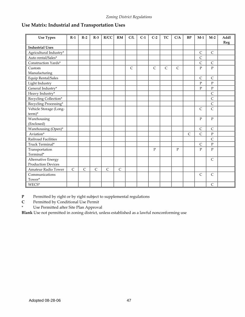
Use Matrix: Industrial and Transportation Uses
Use Types
R-1 R-2 R-3 R/CC RM C/L C-1 C-2 TC C/A BP M-1 M-2 Addl Reg
Industrial Uses Agricultural Industry* C C Auto rental/Sales* C Construction Yards* C C Custom Manufacturing
C C C C P P
Equip Rental/Sales C C Light Industry P P General Industry* P P Heavy Industry* C Recycling Collection* C Recycling Processing* C Vehicle Storage (Long-term)*
C C
Warehousing (Enclosed)
P P
Warehousing (Open)* C C Aviation* C C P Railroad Facilities C Truck Terminal* C P Transportation Terminal*
P P P P
Alternative Energy Production Devices
C
Amateur Radio Tower C C C C C Communications Tower*
C C
WECS* C
P Permitted by right or by right subject to supplemental regulations C Permitted by Conditional Use Permit * Use Permitted after Site Plan Approval Blank Use not permitted in zoning district, unless established as a lawful nonconforming use
Zoning District Regulations
Adopted 08-28-06 48
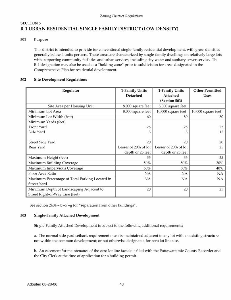
SECTION 5 R-1 URBAN RESIDENTIAL SINGLE-FAMILY DISTRICT (LOW-DENSITY)
501 Purpose
This district is intended to provide for conventional single-family residential development, with gross densities generally below 4 units per acre. These areas are characterized by single-family dwellings on relatively large lots with supporting community facilities and urban services, including city water and sanitary sewer service. The R-1 designation may also be used as a “holding zone” prior to subdivision for areas designated in the Comprehensive Plan for residential development.
502 Site Development Regulations
Regulator 1-Family Units
Detached 1-Family Units
Attached (Section 503)
Other Permitted Uses
Site Area per Housing Unit 8,000 square feet 5,000 square feet Minimum Lot Area 8,000 square feet 10,000 square feet 10,000 square feet Minimum Lot Width (feet) 60 80 80 Minimum Yards (feet) Front Yard Side Yard Street Side Yard Rear Yard
25
5
20 Lesser of 20% of lot
depth or 25 feet
25
5
20 Lesser of 20% of lot
depth or 25 feet
25 15
20 25
Maximum Height (feet) 35 35 35 Maximum Building Coverage 50% 50% 30% Maximum Impervious Coverage 60% 60% 40% Floor Area Ratio NA NA NA Maximum Percentage of Total Parking Located in Street Yard
NA NA NA
Minimum Depth of Landscaping Adjacent to Street Right-of-Way Line (feet)
20 20 25
See section 2404 – b –5 –g for “separation from other buildings”.
503 Single-Family Attached Development
Single-Family Attached Development is subject to the following additional requirements:
a. The normal side yard setback requirement must be maintained adjacent to any lot with an existing structure not within the common development; or not otherwise designated for zero lot line use. b. An easement for maintenance of the zero lot line facade is filed with the Pottawattamie County Recorder and the City Clerk at the time of application for a building permit.

Zoning District Regulations
Adopted 08-28-06 49
SECTION 6 R-2 URBAN RESIDENTIAL MIXED DENSITY DISTRICT 601 Purpose
This district is intended to provide for moderate density residential development, with gross densities generally between 4 and 12 units per acre. These developments are characterized by single-family dwellings on moderately sized lots along with low-density multi-unit residential structures such as duplexes and townhouses. It provides regulations to encourage innovative forms of housing development. It adapts to both established and developing neighborhoods, as well as transitions between single-family and multi-family areas.
602 Site Development Regulations
Regulator 1-Family
Detached
1-Family Attached (Section
604)
Duplex Town-house
(Section 603)
Other Permitted Uses
Site Area per Housing Unit (square feet) In Conventional Development In Planned Developments
6,000 5,000
5,000 5,000
3,000 3,000
3,000 2,500
Minimum Lot Area In Conventional Development In Planned Developments
6,000 4,000
5,000 4,000
6,000 6,000
3,000 2,500
6,000 6,000
Minimum Lot Width (feet) In Conventional Development In Planned Developments
60 45
50 40
75 65
35 25
60 60
Minimum Yards (feet) (Section 605) Front Yard Side Yard on detached sides Street Side Yard Rear Yard
25 5 15 25
25 10 15 25
25 10 15 25
25 10 15 25
25 10 15 25
Maximum Height (feet) 35 35 35 35 35 Maximum Building Coverage 45% 45% 45% 45% 45% Maximum Impervious Coverage 55% 55% 55% 55% 55% Floor Area Ratio NA NA NA NA 0.50 Maximum Percentage of Total Parking Located in Street Yard
NA NA NA NA 50%
Minimum Depth of Landscaping Adjacent to Street Right-of-Way Line (feet)
20 20
20 20 20
603 Townhouse Development
No more than four units may be attached in a single townhouse structure within an R-2 District.

Zoning District Regulations
Adopted 08-28-06 50
604 1-Family Attached Development
Within a common development, one interior side yard may be equal to zero for single-family detached residential use if: a. The normal side yard setback requirement must be maintained adjacent to any lot with an existing structure not within the common development; or not otherwise designated for zero lot line use. b. An easement for maintenance of the zero lot line facade is filed with the Pottawattamie County Recorder and the City Clerk at the time of application for a building permit.
605 Flexible Yard Setbacks in Planned Districts
The Planning Board and City Council may vary required minimum setbacks in planned districts. However, the setback from the front facade of a garage to any public or private street right-of-way (including the boundary of sidewalks) must be at least 20 feet.

Zoning District Regulations
Adopted 08-28-06 51
SECTION 7 R-3 URBAN RESIDENTIAL MULTI-FAMILY DISTRICT 701 Purpose
This district is intended to provide for low and medium density multi-family residential development, with gross densities generally between 12 and 24 units per acre. These developments often are characterized by low-rise buildings in multiple structure configurations, with an emphasis on open space, convenient parking, and, in many cases, common community facilities such as clubhouses and swimming pools. This district is also appropriate for larger townhouse complexes, while still accommodating lower density forms of development.
702 Site Development Regulations
Regulator 1-Family Detached
1-Family Attached
Duplex Town-house
Multi-Family
Other Permitted
Uses Site Area per Housing Unit (sq ft) Conventional Development Planned Developments
6,000 5,000
6,000 5,000
3,000 3,000
2,500 2,000
2,000 1,500
Minimum Lot Area Conventional Development Planned Developments
6,000 4,000
5,000 4,000
6,000 6,000
3,000 2,500
10,000
1.0 acre
6,000 6,000
Minimum Lot Width (feet) Conventional Development Planned Developments
60 45
45 40
75 65
35 25
100 150
60 60
Minimum Yards (feet) (Section 704) Front Yard Side Yard on detached side Street Side Yard Rear Yard
25 * 7 15 25
25 * 7 15 25
25
* 10 15 25
25
* 15 15 25
30 25 25 25
25 10 15 25
Maximum Height (feet) 35 35 35 35 35 35 Maximum Building Coverage 55% 55% 55% 55% 55% 45% Maximum Impervious Coverage 65% 65% 65% 65% 65% 55% Floor Area Ratio NA NA NA NA 0.50 0.50 Maximum Percentage of Total Parking Located in Street Yard
NA NA NA NA 50% 50%
Minimum Depth of Landscaping Adjacent to Street Right-of-Way Line (feet)
20 20
20 20 20 20
* 5 ft for one story. 5 ft for each additional story. 1 F. Multifamily Setback requirements adjacent to R1 & R2 No requirements. Setback requirements curb vs. no curb. No requirements.
Performance Point Requirements In order to receive a permit to proceed with development, project must attain a minimum of 30 performance points, achieved as indicated in the tables in Section 1403 of this document.

Zoning District Regulations
Adopted 08-28-06 52
703 1-Family Attached Development
Within a common development, one interior side yard may be equal to zero for single-family detached residential use if:
a. The normal side yard setback requirement must be maintained adjacent to any lot with an existing structure not within the common development; or not otherwise designated for zero lot line use. b. An easement for maintenance of the zero lot line facade is filed with the Pottawattamie County Recorder and the City Clerk at the time of application for a building permit.
704 Flexible Yard Setbacks in Planned Districts
The Planning Board and City Council may vary required minimum setbacks in planned districts. However, the setback from the front facade of a garage to any public or private street right-of-way (including the boundary of sidewalks) must be at least 20 feet.
705 Additional Requirements
a. Parking areas, accessory buildings, and garages must be at least 10 feet from a side or rear lot line. A greater separation from residential zoning districts may be required by Section 26. b. Swimming pools must be at least 5 feet from a side or rear lot line.
Zoning District Regulations
Adopted 08-28-06 53
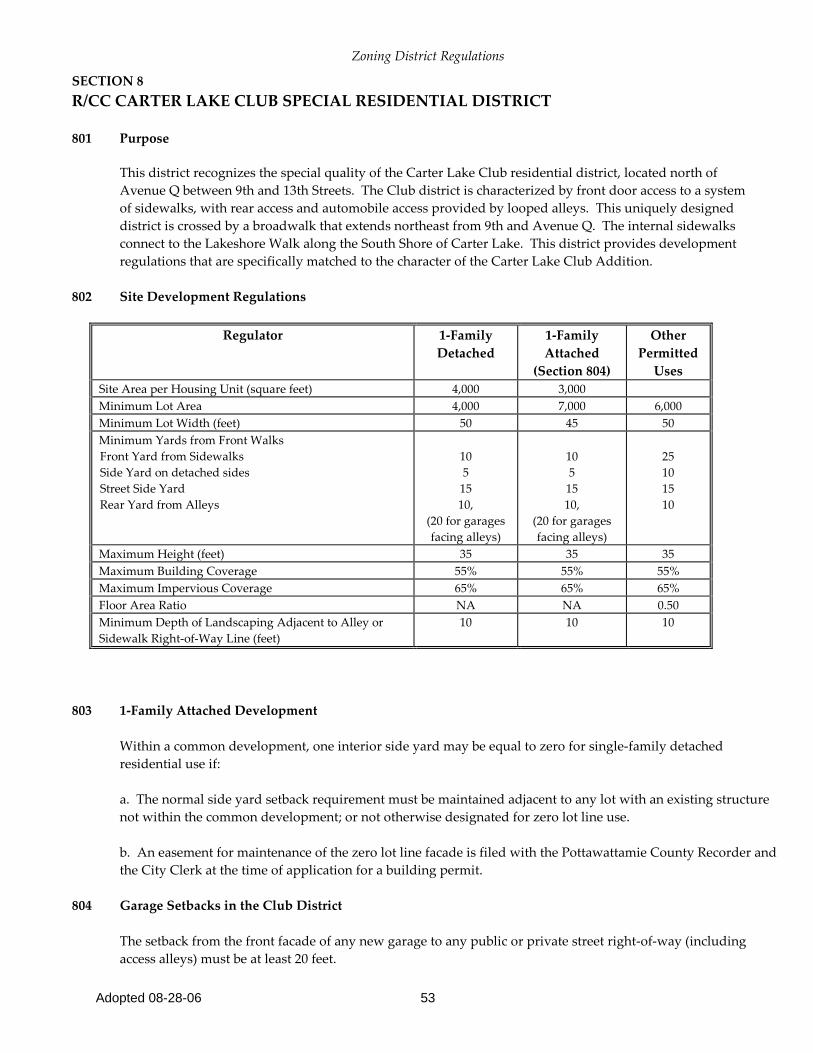
SECTION 8 R/CC CARTER LAKE CLUB SPECIAL RESIDENTIAL DISTRICT
801 Purpose
This district recognizes the special quality of the Carter Lake Club residential district, located north of Avenue Q between 9th and 13th Streets. The Club district is characterized by front door access to a system of sidewalks, with rear access and automobile access provided by looped alleys. This uniquely designed district is crossed by a broadwalk that extends northeast from 9th and Avenue Q. The internal sidewalks connect to the Lakeshore Walk along the South Shore of Carter Lake. This district provides development regulations that are specifically matched to the character of the Carter Lake Club Addition.
802 Site Development Regulations
Regulator 1-Family
Detached
1-Family Attached
(Section 804)
Other Permitted
Uses Site Area per Housing Unit (square feet) 4,000 3,000 Minimum Lot Area 4,000 7,000 6,000 Minimum Lot Width (feet) 50 45 50 Minimum Yards from Front Walks Front Yard from Sidewalks Side Yard on detached sides Street Side Yard Rear Yard from Alleys
10 5
15 10,
(20 for garages facing alleys)
10 5
15 10,
(20 for garages facing alleys)
25 10 15 10
Maximum Height (feet) 35 35 35 Maximum Building Coverage 55% 55% 55% Maximum Impervious Coverage 65% 65% 65% Floor Area Ratio NA NA 0.50 Minimum Depth of Landscaping Adjacent to Alley or Sidewalk Right-of-Way Line (feet)
10 10
10
803 1-Family Attached Development
Within a common development, one interior side yard may be equal to zero for single-family detached residential use if: a. The normal side yard setback requirement must be maintained adjacent to any lot with an existing structure not within the common development; or not otherwise designated for zero lot line use. b. An easement for maintenance of the zero lot line facade is filed with the Pottawattamie County Recorder and the City Clerk at the time of application for a building permit.
804 Garage Setbacks in the Club District
The setback from the front facade of any new garage to any public or private street right-of-way (including access alleys) must be at least 20 feet.

Zoning District Regulations
Adopted 08-28-06 54
SECTION 9 RM MOBILE HOME RESIDENTIAL DISTRICT 901 Purpose
It is recognized that mobile home development, properly planned, can provide important opportunities for affordable housing. This District designation provides opportunities for mobile home development within planned parks or subdivisions, along with the supporting services necessary to create quality residential neighborhoods. The purpose of this chapter is to provide for municipal regulation of mobile homes and mobile home parks in furtherance of the public health, safety, morals and welfare.
902 Site Development Regulations
* Private Street ** Public Street
903 Flexible Yard Setbacks in Planned Districts
The Planning Board and City Council may vary required minimum setbacks in planned districts. However, the setback from the front facade of a garage to any public or private street right-of-way including the boundary of sidewalks) must be at least 20 feet.
904 Additional Requirements
a. Parking areas, accessory buildings, and garages must be at least 10 feet from a side or rear lot line. A greater separation from residential zoning districts may be required by Section 26.
Regulator 1 Family Detached
Other Permitted
Uses Site Area per Housing Unit (square feet) In Conventional Development
6,000
Minimum Lot Area In Conventional Development
6,000
6,000
Minimum Lot Width (feet) In Conventional Development
60
60
Minimum Yards (feet) Front Yard Side Yard Street Side Yard Rear Yard
25 5
15 25
25 10 15 25
Maximum Height (feet) 35 35 Maximum Building Coverage 45% 45% Maximum Impervious Coverage 60% 60% Floor Area Ratio NA 0.50 Maximum Percentage of Total Parking Located in Street Yard NA 50% Minimum Depth of Landscaping Adjacent to Street Right-of-
Way Line (feet) 20 * 35**
20 * 35 *
Zoning District Regulations
Adopted 08-28-06 55
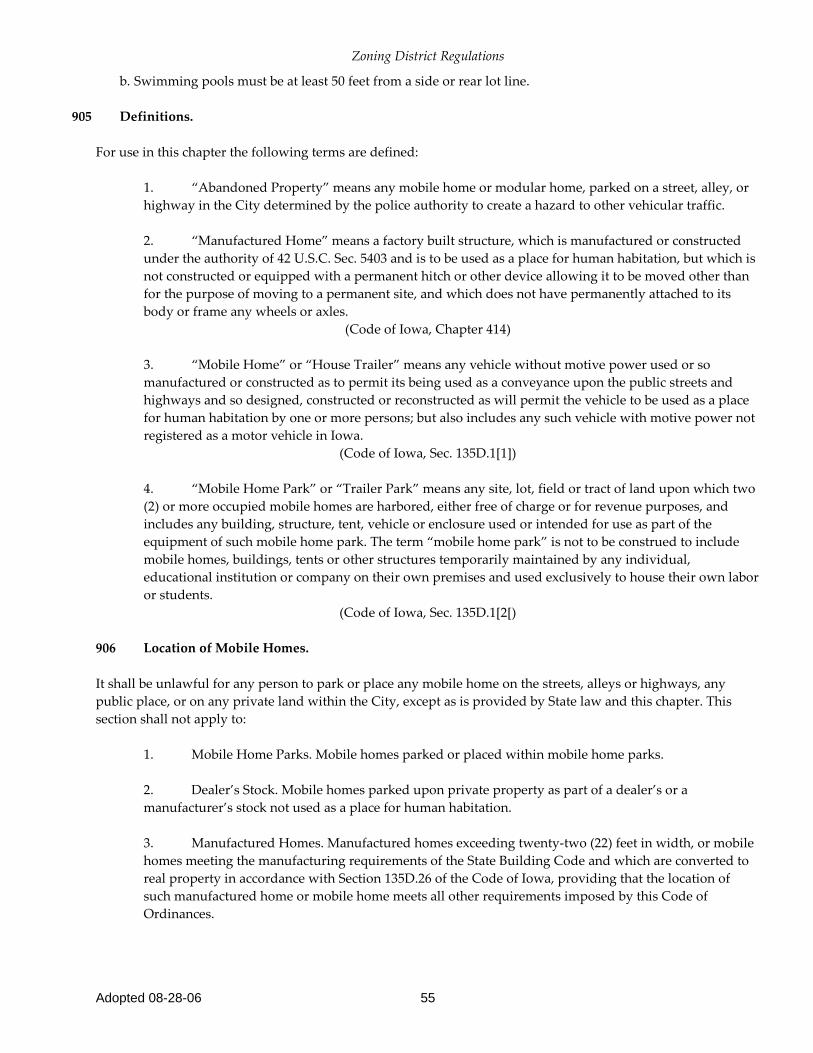
b. Swimming pools must be at least 50 feet from a side or rear lot line.
905 Definitions.
For use in this chapter the following terms are defined: 1. “Abandoned Property” means any mobile home or modular home, parked on a street, alley, or
highway in the City determined by the police authority to create a hazard to other vehicular traffic. 2. “Manufactured Home” means a factory built structure, which is manufactured or constructed
under the authority of 42 U.S.C. Sec. 5403 and is to be used as a place for human habitation, but which is not constructed or equipped with a permanent hitch or other device allowing it to be moved other than for the purpose of moving to a permanent site, and which does not have permanently attached to its body or frame any wheels or axles.
(Code of Iowa, Chapter 414) 3. “Mobile Home” or “House Trailer” means any vehicle without motive power used or so
manufactured or constructed as to permit its being used as a conveyance upon the public streets and highways and so designed, constructed or reconstructed as will permit the vehicle to be used as a place for human habitation by one or more persons; but also includes any such vehicle with motive power not registered as a motor vehicle in Iowa.
(Code of Iowa, Sec. 135D.1[1]) 4. “Mobile Home Park” or “Trailer Park” means any site, lot, field or tract of land upon which two
(2) or more occupied mobile homes are harbored, either free of charge or for revenue purposes, and includes any building, structure, tent, vehicle or enclosure used or intended for use as part of the equipment of such mobile home park. The term “mobile home park” is not to be construed to include mobile homes, buildings, tents or other structures temporarily maintained by any individual, educational institution or company on their own premises and used exclusively to house their own labor or students.
(Code of Iowa, Sec. 135D.1[2[) 906 Location of Mobile Homes. It shall be unlawful for any person to park or place any mobile home on the streets, alleys or highways, any public place, or on any private land within the City, except as is provided by State law and this chapter. This section shall not apply to: 1. Mobile Home Parks. Mobile homes parked or placed within mobile home parks. 2. Dealer’s Stock. Mobile homes parked upon private property as part of a dealer’s or a
manufacturer’s stock not used as a place for human habitation. 3. Manufactured Homes. Manufactured homes exceeding twenty-two (22) feet in width, or mobile
homes meeting the manufacturing requirements of the State Building Code and which are converted to real property in accordance with Section 135D.26 of the Code of Iowa, providing that the location of such manufactured home or mobile home meets all other requirements imposed by this Code of Ordinances.
Zoning District Regulations
Adopted 08-28-06 56
907 Special Permits. The Council, upon application of a mobile home owner, may issue special permits for the location of mobile homes outside mobile home parks. The Council shall issue such special permits only when it appears that location within local mobile home parks is impracticable and public health, safety and welfare interests will not be seriously affected by granting the permit. Special permits shall not be granted for periods in excess of fourteen (14) days except in the case of a bona fide owner of a lot or lots who is in the process of building a permanent home on the premises, in which case, the owner may occupy the lot(s) with a mobile home for use as a temporary home for a period not to exceed six (6) months. Not more than one mobile home shall be permitted to be located on the same premises outside of mobile home parks. At expiration, permits may be renewed for a like period of time upon submitting to the Council a new application, together with the reasons for requesting the extension. 908 Application for Special Permit. Application for a special permit shall be accompanied by an inspection fee of one dollar ($1.00). The application shall contain: 1. Description of Mobile Home. A description of the applicant’s mobile home. 2. Property Description. A property description of the place where the mobile home will be
located. 3. Property Owner. The name of the owner of the premises upon which the mobile home will be
located together with the written approval from the owner of the premises where the mobile home will be located.
4. Sanitation Facilities. Information on sanitation facilities of the mobile home and those available
at the place of location. 5. Mobile Home Park. A statement concerning the practicability of location within a local mobile
home park. 6. Duration of Permit. A statement of the desired duration of the special permit. 909 Emergency and Temporary Parking. Nonresidents of the City may park a travel trailer or motor home on any street, alley, highway or other public place within the corporate limits of the City subject to a permit being issued by the City and to any other and further prohibitions, regulations or limitations imposed by the traffic and parking regulations pertaining to streets, alleys or highways. 910 Storage Fees and Costs. The owner of any mobile home or modular home placed or left in a street, alley, highway or other public place within the City shall be responsible for the costs of towing and storage for said mobile home or modular home. The charge for storage of said mobile home or modular home shall be the sum of fifty dollars ($50.00) per day.
Zoning District Regulations
Adopted 08-28-06 57
911 Auction Sale. All mobile homes or modular homes impounded by the police department shall be sold pursuant to Section 321.89 and subsequent sections of the Code of Iowa. 912 Authority to Take Possession of Abandoned Property. A police authority may take into custody any abandoned mobile home or modular home and shall remove, preserve, store and dispose of said abandoned property. 913 Trailer Park Permit Required. It is unlawful for any person to construct within the limits of the City any trailer park unless such person shall first obtain a permit therefore. 914 Permit Application. Any person desiring to construct a trailer park shall first file with the Clerk/Treasurer written application in duplicate on a form furnished by the City for a trailer park permit. Applications shall be accompanied by a plat and other documents showing the following information:
1. The name and address of the applicant; 2. A legal description of the trailer park area, and extent of area to be used for trailer park purposes; 3. The location and legal description of the trailer park; 4. Location and site of trailer lots; 5. Location, number and type of service buildings; 6. Plans and specifications of all other buildings and improvements constructed or to be constructed within the trailer park; 7. Method and plan of 8. Public water supply taps and facilities; 9. Method and plan of garbage disposal; 10. Plan of electric lighting including the location of exterior park lights and the electric facilities provided for trailers; 11. Incinerator and burning space; 12. Children’s play area; 13. Drainage facilities; and 14. Fire protection facilities.
Zoning District Regulations
Adopted 08-28-06 58
All accompanying plans and specifications, as set out in this section, shall also be filed in duplicate. 915 Inspection of Plans. The health department, building, plumbing and electrical inspectors, planning and zoning commissions, and fire chief shall inspect the proposed plans. If it is found that the proposed trailer park will be in compliance with all provisions of this chapter and all other applicable ordinances or statutes, such report shall be made to the Council, which shall approve the application and issue the permit. 916 Location Within City Restricted. No trailer park shall be located within the limits of the City except in a commercial or industrial zone, as designated by City ordinance. 917 Water and Sewer Connection. No trailer park shall be located in the City unless it has City water available to it, and unless it is connected with the City’s sanitary sewer system, if available, or proper sanitary facilities if sewer connection is not so available. 918 Location in Regard to Setback and Other Buildings. No occupied trailer or service building shall be located within the City limits within the recognized setback line for the zoning districts in which such trailer is located, nor less than ten feet from any other building. No trailer shall be located nearer than fifteen (15) feet to any public street or highway. 919 Conformance With Other Ordinances. Nothing in this chapter shall be deemed or construed to repeal, abrogate or modify any zoning ordinance or any provisions thereof in effect in the City. 920 Site Drainage and Grade. Each park shall be located on a well-drained site, properly graded to ensure rapid drainage and freedom from stagnant pools of water. 921 Entrance and Exit. Each park shall have a surfaced entrance and exit, the entrance and exit, or either of them, being not less than eighteen feet in width and plainly marked in the daytime and adequately lighted at night. 922 Lot Size. Each park shall be divided into lots for each trailer, each lot having an area not less than twenty-eight hundred square feet with a minimum width of forty feet and minimum depth of seventy (70) feet. 923 Driveways. All trailer lots shall face or abut upon a driveway of not less than twenty feet in width which shall have unobstructed access to a public street, alley or highway. All driveways shall be all-weather surfaced, well
Zoning District Regulations
Adopted 08-28-06 59
marked in the daytime and lighted at night, with twenty-five watt lamps at intervals of one hundred feet located approximately fifteen feet from the ground, or equivalent lighting. 924 Service Buildings Required. Each park shall provide service buildings to house toilet facilities, bathing facilities, laundry facilities, and other sanitary facilities as more particularly prescribed in Sections 123.22 through 123.31. 925 Outlet on Lot. Every trailer lot shall be furnished with an electric service outlet. Such outlet shall be equipped with an externally operated switch or fuse of not less than thirty amperes capacity and a heavy-duty outlet receptacle. 926 Water Supply for Park. An adequate water supply obtained from the water system of the City must, at all times, be furnished to each trailer park in sufficient quantities to meet all requirements of the park. The water supply shall be connected to the individual trailer or be furnished from faucets conveniently located in the trailer park. A cold water supply shall be located on all lots in a trailer park. 927 Drinking Water System. No common drinking vessels shall be permitted, nor shall any drinking water faucets be placed in any toilet room or water closet compartment. 928 Hot Water Provided. An abundant supply of hot water shall be provided at all times for bathing, washing, and laundry facilities. 929 Condition of Service Buildings. All service buildings and the grounds of the park shall be maintained in a clean, sightly condition and kept free of any condition that will menace the health of any occupant or the public, or constitute a nuisance. 930 Laundry Facilities. The laundry facilities shall be provided in the ratio of one washing machine for every twenty trailer lots. Dryers shall be provided sufficient to accommodate the laundry of the trailer occupants. The service building housing the laundry facilities shall be a permanent structure complying with all applicable ordinances and statutes regulating buildings, electrical installations and plumbing and sanitation systems. 931 Waste System. All waste from showers, toilets, laundries, faucets and lavatories shall be wasted into a sewer system extended from and connected with the City sewer system if available, otherwise an adequate sanitary disposal system. All trailer lots in a trailer park shall be equipped with a sanitary sewer drain for direct connection with a trailer in such lot.

Zoning District Regulations
Adopted 08-28-06 60
932 Connection With City Required. All sanitary facilities in any trailer which are not connected with the City sewer system by means of rigid connections shall be sealed and their use is declared unlawful. 933 Waste Water Disposal. In no case shall any wastewater be thrown or discharged upon the surface of the ground or disposed of by any means other than provided in this chapter. 934 Garbage Receptacles. Metal or plastic garbage receptacles shall be provided on the basis of one receptacle for every four trailer lots, and shall be located not farther than fifty feet from any trailer lot. The cans shall be tightly covered and shall be kept in sanitary condition. Garbage and rubbish shall be collected and disposed of by the City garbage collection service. Sufficient receptacles shall be provided to prevent littering the ground with rubbish and debris. 935 Fire Extinguisher Requirements. Each service building shall be equipped with not less than one ten-pound ABC extinguisher on each floor or level of the buildings. 936 Playing Space. Adequate playing space shall be provided for the children. 937 Permit Not Transferable. The permit shall not be transferable from one location to another. 938 Additions to Trailer. No additions shall be built onto any trailer, which shall leave a clearance of less than ten clear feet between the addition and the next trailer. No fences or enclosures shall be constructed without application made to the Building Inspector and a permit issued for such construction. The necessary permit shall be secured before building such structure, which must comply with statutes of the State and ordinances of the City pertaining to housing. 939 Change of Plan. Any change to be made in a trailer park plan after a permit to construct a trailer park has been obtained shall be filed with the Clerk/Treasurer and the approval thereof secured from the Council. 940 Enclosed or Buried Drain and Sewer Pipes. The connections consisting of all pipes, fittings and appurtenances from the drain outlets of the mobile home to the inlet of the corresponding sewer riser pipe of the sewage system serving the mobile home park shall be completely enclosed underneath the mobile home, or if located outside the mobile home, the pipes, fittings and appurtenances shall be buried beneath the ground.
Zoning District Regulations
Adopted 08-28-06 61
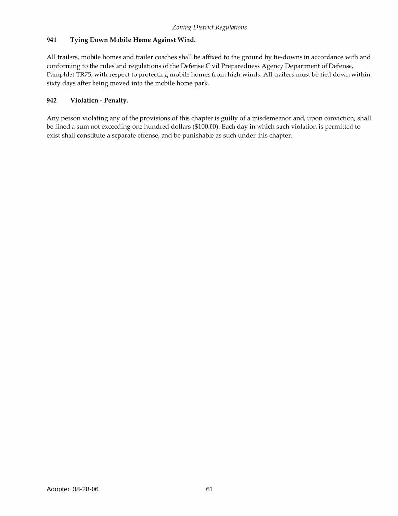
941 Tying Down Mobile Home Against Wind. All trailers, mobile homes and trailer coaches shall be affixed to the ground by tie-downs in accordance with and conforming to the rules and regulations of the Defense Civil Preparedness Agency Department of Defense, Pamphlet TR75, with respect to protecting mobile homes from high winds. All trailers must be tied down within sixty days after being moved into the mobile home park. 942 Violation - Penalty. Any person violating any of the provisions of this chapter is guilty of a misdemeanor and, upon conviction, shall be fined a sum not exceeding one hundred dollars ($100.00). Each day in which such violation is permitted to exist shall constitute a separate offense, and be punishable as such under this chapter.
Zoning District Regulations
Adopted 08-28-06 62
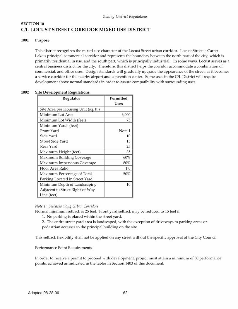
SECTION 10 C/L LOCUST STREET CORRIDOR MIXED USE DISTRICT 1001 Purpose
This district recognizes the mixed-use character of the Locust Street urban corridor. Locust Street is Carter Lake’s principal commercial corridor and represents the boundary between the north part of the city, which is primarily residential in use, and the south part, which is principally industrial. In some ways, Locust serves as a central business district for the city. Therefore, this district helps the corridor accommodate a combination of commercial, and office uses. Design standards will gradually upgrade the appearance of the street, as it becomes a service corridor for the nearby airport and convention center. Some uses in the C/L District will require development above normal standards in order to assure compatibility with surrounding uses.
1002 Site Development Regulations
Regulator Permitted Uses
Site Area per Housing Unit (sq. ft.) Minimum Lot Area 6,000 Minimum Lot Width (feet) 75 Minimum Yards (feet) Front Yard Side Yard Street Side Yard Rear Yard
Note 1
10 15 25
Maximum Height (feet) 35 Maximum Building Coverage 60% Maximum Impervious Coverage 80% Floor Area Ratio 1.0 Maximum Percentage of Total Parking Located in Street Yard
50%
Minimum Depth of Landscaping Adjacent to Street Right-of-Way Line (feet)
10
Note 1: Setbacks along Urban Corridors Normal minimum setback is 25 feet. Front yard setback may be reduced to 15 feet if:
1. No parking is placed within the street yard. 2. The entire street yard area is landscaped, with the exception of driveways to parking areas or pedestrian accesses to the principal building on the site.
This setback flexibility shall not be applied on any street without the specific approval of the City Council. Performance Point Requirements In order to receive a permit to proceed with development, project must attain a minimum of 30 performance points, achieved as indicated in the tables in Section 1403 of this document.

Zoning District Regulations
Adopted 08-28-06 63
1003 Special Regulations and Standards
a. Architectural details, including materials, textures, patterns, colors, and design features used on any facade facing a street or easily seen by the public shall be included in the plans and approved by the planning board. b. All service and loading areas shall be entirely screened from view. c. All buildings and developments shall include a direct, clear, and safe pedestrian connection from adjacent public sidewalks to the entrances of buildings within the development.

Zoning District Regulations
Adopted 08-28-06 64
SECTION 11 C-1 LIMITED COMMERCIAL DISTRICT
1101 Purpose
The C-1 Limited Commercial District is intended for neighborhood shopping facilities serving the needs of residents of a surrounding residential area. Allowed commercial and office uses are generally compatible with nearby residential areas in scale and intensity. Site development regulations are intended to ensure compatibility in size, scale, and site characteristics with these residential environments. C-1 districts are generally most appropriate at intersections of collector and/or arterial streets, at the edge of residential areas, in planned commercial areas in newly developing residential districts, or at other locations where local commercial services are required.
1102 Site Development Regulations for C-1 Districts
Regulator Permitted Uses
Site Area per Housing Unit (sq. ft.) NA Minimum Lot Area 6,000 Minimum Lot Width (feet) 60 Minimum Yards (feet) Front Yard (Note 1) Side Yard Street Side Yard Rear Yard
15
7 15
Less of 15% of lot depth or 20 feet
Maximum Height (feet) 35 Maximum Building Coverage 60% Maximum Impervious Coverage 80% Floor Area Ratio (Note 2) 0.5 Maximum Percentage of Total Parking Located in Street Yard
75%
Minimum Depth of Landscaping Adjacent to Street Right-of-Way Line (feet)
10
Note 1: Flexible Yard Setbacks in Planned Districts The Planning Board and City Council may vary required minimum setbacks in planned districts. However, the setback from the front facade of a garage to any public or private street right-of-way (including the boundary of sidewalks) must be at least 20 feet. Note 2: Flexible Floor Area Ratios in Planned Districts The Planning Board and City Council may increase the maximum Floor Area Ratio for a development in a planned district. Performance Point Requirements In order to receive a permit to proceed with development, project must attain a minimum of 30 performance points, achieved as indicated in the tables in Section 1403 of this document.

Zoning District Regulations
Adopted 08-28-06 65
1103 Special Regulations and Standards
a. Architectural details, including materials, textures, patterns, colors, and design features used on any façade facing a street or easiest seen by the public shall be included in the plans and approved by the Planning Board. b. All service and loading areas shall be entirely screened from view. c. All buildings and developments shall include a direct, clear, and safe pedestrian connection from adjacent public sidewalks to the entrances of buildings within the development.
Zoning District Regulations
Adopted 08-28-06 66
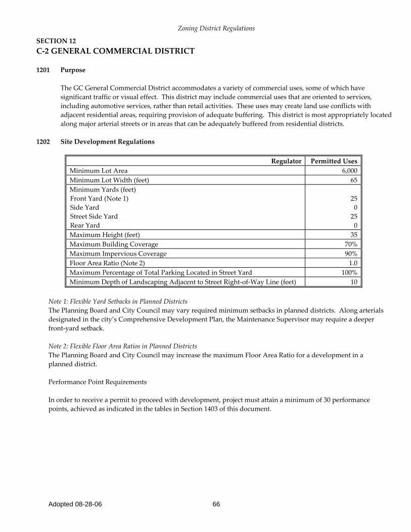
SECTION 12 C-2 GENERAL COMMERCIAL DISTRICT
1201 Purpose
The GC General Commercial District accommodates a variety of commercial uses, some of which have significant traffic or visual effect. This district may include commercial uses that are oriented to services, including automotive services, rather than retail activities. These uses may create land use conflicts with adjacent residential areas, requiring provision of adequate buffering. This district is most appropriately located along major arterial streets or in areas that can be adequately buffered from residential districts.
1202 Site Development Regulations
Regulator Permitted Uses
Minimum Lot Area 6,000 Minimum Lot Width (feet) 65 Minimum Yards (feet) Front Yard (Note 1) Side Yard Street Side Yard Rear Yard
25
0 25
0 Maximum Height (feet) 35 Maximum Building Coverage 70% Maximum Impervious Coverage 90% Floor Area Ratio (Note 2) 1.0 Maximum Percentage of Total Parking Located in Street Yard 100% Minimum Depth of Landscaping Adjacent to Street Right-of-Way Line (feet) 10
Note 1: Flexible Yard Setbacks in Planned Districts The Planning Board and City Council may vary required minimum setbacks in planned districts. Along arterials designated in the city’s Comprehensive Development Plan, the Maintenance Supervisor may require a deeper front-yard setback. Note 2: Flexible Floor Area Ratios in Planned Districts The Planning Board and City Council may increase the maximum Floor Area Ratio for a development in a planned district. Performance Point Requirements In order to receive a permit to proceed with development, project must attain a minimum of 30 performance points, achieved as indicated in the tables in Section 1403 of this document.

Zoning District Regulations
Adopted 08-28-06 67
1203 Special Regulations and Standards
a. Architectural details, including materials, textures, patterns, colors, and design features used on any façade facing a street or easiest seen by the public shall be included in the plans and approved by the planning board. b. All service and loading areas shall be entirely screened from view. c. All buildings and developments shall include a direct, clear, and safe pedestrian connection from adjacent public sidewalks to the entrances of buildings within the development.
Zoning District Regulations
Adopted 08-28-06 68
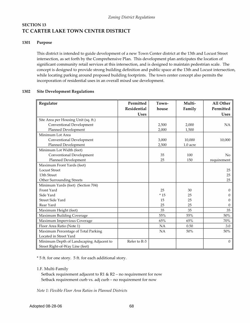
SECTION 13 TC CARTER LAKE TOWN CENTER DISTRICT
1301 Purpose
This district is intended to guide development of a new Town Center district at the 13th and Locust Street intersection, as set forth by the Comprehensive Plan. This development plan anticipates the location of significant community retail services at this intersection, and is designed to maintain pedestrian scale. The concept is designed to provide strong building definition and public space at the 13th and Locust intersection, while locating parking around proposed building footprints. The town center concept also permits the incorporation of residential uses in an overall mixed use development.
1302 Site Development Regulations
Regulator Permitted
Residential Uses
Town-house
Multi-Family
All Other Permitted
Uses Site Area per Housing Unit (sq. ft.) Conventional Development Planned Development
2,500 2,000
2,000 1,500
NA
Minimum Lot Area Conventional Development Planned Development
3,000 2,500
10,000
1.0 acre
10,000
Minimum Lot Width (feet) Conventional Development Planned Development
35 25
100 150
No
requirement Maximum Front Yards (feet) Locust Street 13th Street Other Surrounding Streets
25 25 25
Minimum Yards (feet) (Section 704) Front Yard Side Yard Street Side Yard Rear Yard
25
* 15 15 25
30 25 25 25
0 0 0 0
Maximum Height (feet) 35 35 35 Maximum Building Coverage 55% 55% 50% Maximum Impervious Coverage 65% 65% 70% Floor Area Ratio (Note 1) NA 0.50 3.0 Maximum Percentage of Total Parking Located in Street Yard
NA 50% 50%
Minimum Depth of Landscaping Adjacent to Street Right-of-Way Line (feet)
Refer to R-3 0
* 5 ft. for one story. 5 ft. for each additional story. 1.F. Multi-Family Setback requirement adjacent to R1 & R2 – no requirement for now Setback requirement curb vs. adj curb – no requirement for now Note 1: Flexible Floor Area Ratios in Planned Districts
Zoning District Regulations
Adopted 08-28-06 69
The Planning Board and City Council may increase the maximum Floor Area Ratio for a development in a planned district. Performance Point Requirements In order to receive a permit to proceed with development, project must attain a minimum of 30 performance points, achieved as indicated in the tables in Section 1403 of this document.
1303 Special Regulations and Standards
a. Architectural details, including materials, textures, patterns, colors, and design features used on any façade facing a street or easiest seen by the public shall be included in the plans and approved by the planning board. b. All buildings and developments shall include a direct, clear, and safe pedestrian connection from adjacent public sidewalks to the entrances of buildings within the development. In addition, all buildings in a planned development shall have paths that provide safe and defined pedestrian access to all other buildings in the development. c. Non-residential buildings shall be designed to create the appearance of multiple-tenants, storefronts, and entrances. d. Street orientation includes a consistent building setback, entrances and windows facing the street, and parking areas located to the rear or side of buildings. e. All service and loading areas shall be entirely screened from view.

Zoning District Regulations
Adopted 08-28-06 70
SECTION 14 C/A ABBOTT DRIVE CORRIDOR COMMERCIAL DISTRICT
1401 Purpose
The C/A district addresses development along the Abbott Drive corridor. This strategic corridor is undergoing significant development with commercial and visitor services uses, a demand created by the growth of Eppley Airfield and the development of Omaha’s Qwest Center. The district regulations includes standards appropriate to this type of development and provides special performance based zoning to assure that development in this highly visible corridor exceeds minimum standards.
1402 Site Development Regulations
Regulator Permitted Uses
Minimum Lot Area 8,000 Minimum Lot Width (feet) 80 Minimum Yards (feet) Front Yard (Note 1) Side Yard Street Side Yard Rear Yard
25
0 0 0
Maximum Height (feet) 60 unless reduced by airport approach standards
Maximum Building Coverage 70% Maximum Impervious Coverage 85% Floor Area Ratio (Note 2) 3.0 Maximum Percentage of Total Parking Oriented to Abbott Drive 75% Minimum Depth of Landscaping Adjacent to Street Right-of-Way Line (feet) 15
Note 1: Flexible Yard Setbacks in Planned Districts The Planning Board and City Council may vary required minimum setbacks in planned districts. Along arterials designated in the city’s Comprehensive Development Plan, the Maintenance Supervisor may require a deeper front-yard setback.
Note 2: Flexible Floor Area Ratios in Planned Districts The Planning Board and City Council may increase the maximum Floor Area Ratio for a development in a planned district.
Performance Point Requirements In order to receive a permit to proceed with development, project must attain a minimum of 30 performance points, achieved as indicated in the tables in Section 1403 of this document.

Zoning District Regulations
Adopted 08-28-06 71
1403 Performance Points System for projects in the C/A District (and all zoning districts located south of Ave. K –
R-3, C/L, C-1, C-2, TC, C/A, BP, M-1, M-2) a. Purpose
The Performance Point Evaluation System is designed to ensure that projects in the highly visible Abbott Drive corridor provide an impression of high quality design and amenity. This approach reinforces the major private investments that have been made in the design of the public right-of-way along Abbott Drive. The system requires attainment of a specified number of Performance Points in order for a project to receive a permit to proceed. It further provides a variety of optional design features and enhancements to permit a developer considerable flexibility in choosing appropriate enhancements. b. Application The Performance Point Evaluation System applies to all projects proposed within the C/A District. c. Performance Point Requirements In order to receive a permit to proceed with development, projects must attain a minimum of 30 performance points, achieved as indicated in the following tables. d. Project Evaluation
1. Projects shall be evaluated by the Building inspector, who shall maintain a written record of the evaluation.
2. Administrative evaluations by the Building inspector that result in the denial of a project’s approval may be appealed to the Planning Board. Further appeals of the decision of the Planning Board may be taken to the City Council.
e. Evaluation Standards
Landscaped Areas 1. Base Standard: All projects must provide landscaping consistent with the Minimum Depth and Buffer yard Standards established by their base districts and by the Landscaping Ordinance. 2. Performance Points: Projects earn one point for each foot of landscaping provided back from the street property line in addition to the minimum required standards.
Parking Lot Landscaping 1. Base Standard: All parking lots accommodating 20 or more cars shall provide interior landscaping equal to 5% of the paved area of the parking lot.

Zoning District Regulations
Adopted 08-28-06 72
2. Performance Points: Projects earn points based on the following table: Points Action 0 Project meets minimum standards 5 Project provides 1.25 times the base standard for interior landscaping. 10 Project provides 1.50 times the base standard for interior landscaping. 15 Project provides 2.00 times the base standard for interior landscaping.
Trees
1. Base Standard: All projects must provide one tree of an approved species for each 500 square feet of required landscaping as provided by the Landscaped Area Standards (1403.e1).
2. Performance Points: Projects earn points based on the following table:
Points Action
0 Project meets minimum standards.
5 Project provides 1.25 times the base standard for tree planting. 10 Project provides 1.5 times the base standard for tree planting.
15 Project provides 1.75 times the base standard for tree planting. 20 Project provides 2 times the base standard for tree planting.
Signage
1. Base Standard: Projects must meet the sign requirement set forth in the sign ordinance.
2. Performance Points: Projects earn points based on the following table:
Points Action 0 Total sign area = 80% to 100% of permitted sign area. 5 Total sign area = 70% to 80% of permitted sign area. 10 Total sign area = 60% to 70% of permitted sign area. 15 Total sign area = 50% to 60% of permitted sign area. 20 Total sign area = Less than 50% of permitted sign area.
3. Projects that provide all signage as monument or ground signs earn an additional ten points. All such signs must be located outside of vision clearance zones.
Parking in Street Yard Facing Abbott Drive 1. Base Standard: Projects must meet requirements indicated in the Development Regulations for individual
districts and the parking ordinance.

Zoning District Regulations
Adopted 08-28-06 73
2. Performance Points: Projects earn points based on the following table: Points Action 0 Meets minimum standards. 5 Reduces the amount of street yard parking by 10% below district requirements. 10 Reduces the amount of street yard parking by 20% below district requirements. 15 Reduces the amount of street yard parking by 30% below district requirements. 20 Reduces the amount of street yard parking by 40% below district requirements.
Impervious Coverage
1. Base Standard: Projects must meet requirements indicated in the Development Regulations for individual districts.
2. Performance Points: Projects earn points based on the following table:
Points Action 0 Meets minimum standards 5 Reduces impervious coverage by 10% below district requirements 10 Reduces impervious coverage by 20% below district requirements 15 Reduces impervious coverage by 30% below district requirements 20 Reduces impervious coverage by 40% below district requirements
Building Articulation
1. Base Standard: No requirement
2. Performance Points: Projects earn points based on the following table: Points Action 5 Building provides a minimum offset of 5 feet for every 100 feet of length of the facade
parallel to the corridor’s major street. 10 Building provides a minimum offset of 5 feet for every 75 feet of length of the facade
parallel to corridor’s major street. 15 Building provides a minimum offset of 5 feet for every 50 feet of length of the facade
parallel to corridor’s major street. Building Materials 1. Base Standard: No requirement
Zoning District Regulations
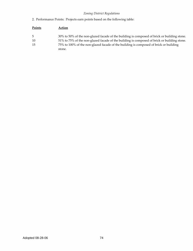
Adopted 08-28-06 74
2. Performance Points: Projects earn points based on the following table: Points Action 5 30% to 50% of the non-glazed facade of the building is composed of brick or building stone. 10 51% to 75% of the non-glazed facade of the building is composed of brick or building stone. 15 75% to 100% of the non-glazed facade of the building is composed of brick or building
stone.

Zoning District Regulations
Adopted 08-28-06 75
SECTION 15 BP BUSINESS PARK DISTRICT
1501 Purpose
The BP Business Park district is intended to promote the development of planned business parks that accommodate office, and commercial uses. These facilities serve a more regional audience, but may provide services to local residents. They are characterized by extensive landscaping, abundant parking facilities, and good visual and pedestrian relationships among buildings. BP zoning is appropriate to existing developments such as Owen Parkway and other proposed development along the Missouri Riverfront.
1502 Site Development Regulations
Regulator Permitted Uses Minimum Lot Area (square feet) 20,000 Minimum Lot Width (feet) 100 Minimum Yards (feet) Front Yard (Note 1) Side Yard Street Side Yard Rear Yard
30 10 25 30
Maximum Height (feet) “unless reduced by airport approach standard” 60 Maximum Building Coverage 50% Maximum Impervious Coverage 70% Floor Area Ratio (Note 2) 2.0 Maximum Percentage of Total Parking Located in Street Yard 50% Minimum Depth of Landscaping Adjacent to Street Right-of-Way Line (feet) 20
Note 1: Flexible Yard Setbacks in Planned Districts The Planning Board and City Council may vary required minimum setbacks in planned districts. Note 2: Flexible Floor Area Ratios in Planned Districts The Planning Board and City Council may increase the maximum Floor Area Ratio for a development in a planned district. Performance Point Requirements
In order to receive a permit to proceed with development, project must attain a minimum of 30 performance points, achieved as indicated in the tables in Section 1403 of this document.
Zoning District Regulations
Adopted 08-28-06 76
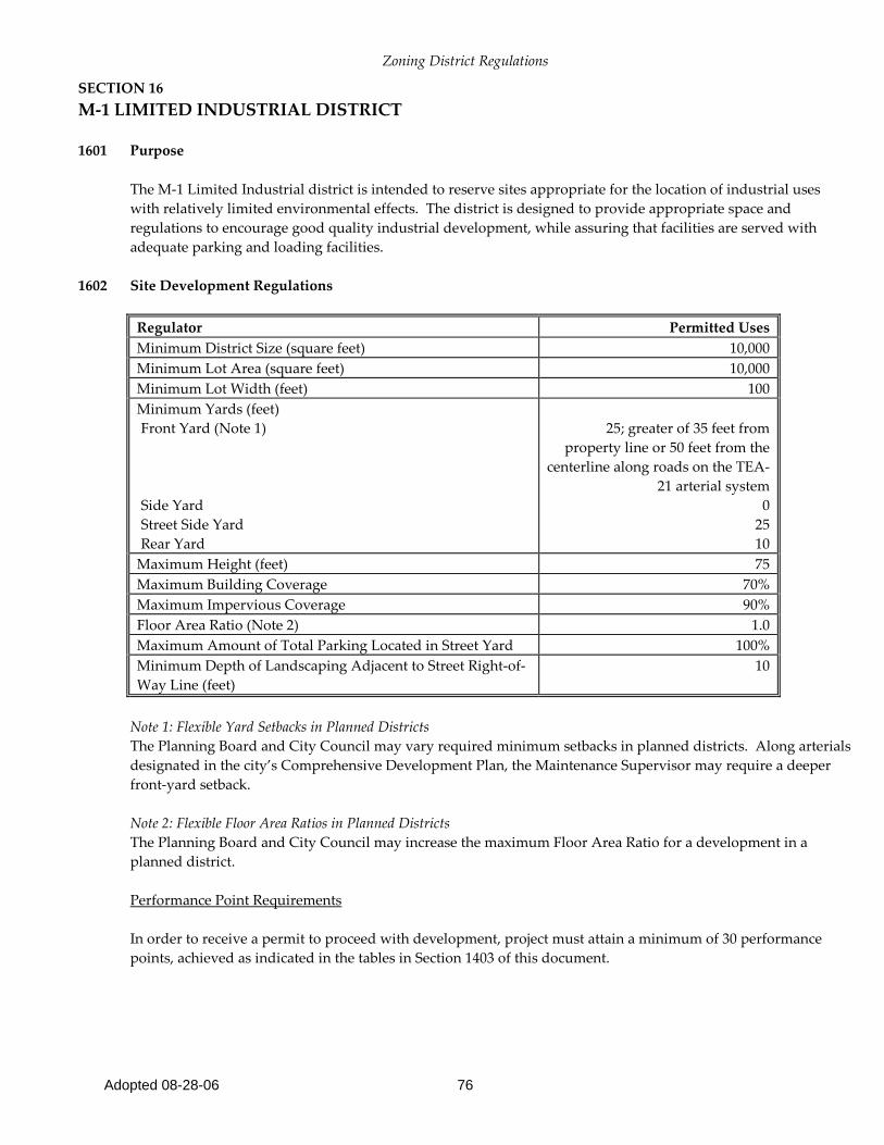
SECTION 16 M-1 LIMITED INDUSTRIAL DISTRICT
1601 Purpose
The M-1 Limited Industrial district is intended to reserve sites appropriate for the location of industrial uses with relatively limited environmental effects. The district is designed to provide appropriate space and regulations to encourage good quality industrial development, while assuring that facilities are served with adequate parking and loading facilities.
1602 Site Development Regulations
Regulator Permitted Uses Minimum District Size (square feet) 10,000 Minimum Lot Area (square feet) 10,000 Minimum Lot Width (feet) 100 Minimum Yards (feet) Front Yard (Note 1) Side Yard Street Side Yard Rear Yard
25; greater of 35 feet from
property line or 50 feet from the centerline along roads on the TEA-
21 arterial system 0
25 10
Maximum Height (feet) 75 Maximum Building Coverage 70% Maximum Impervious Coverage 90% Floor Area Ratio (Note 2) 1.0 Maximum Amount of Total Parking Located in Street Yard 100% Minimum Depth of Landscaping Adjacent to Street Right-of-Way Line (feet)
10
Note 1: Flexible Yard Setbacks in Planned Districts The Planning Board and City Council may vary required minimum setbacks in planned districts. Along arterials designated in the city’s Comprehensive Development Plan, the Maintenance Supervisor may require a deeper front-yard setback. Note 2: Flexible Floor Area Ratios in Planned Districts The Planning Board and City Council may increase the maximum Floor Area Ratio for a development in a planned district. Performance Point Requirements In order to receive a permit to proceed with development, project must attain a minimum of 30 performance points, achieved as indicated in the tables in Section 1403 of this document.

Zoning District Regulations
Adopted 08-28-06 77
SECTION 17 M-2 GENERAL INDUSTRIAL DISTRICT
1701 Purpose
The M-2 General Industrial district is intended to accommodate a wide variety of industrial uses, some of which may have significant external effects. These uses may have operating characteristics that create conflicts with lower-intensity surrounding land uses. The district provides the reservation of land for these activities and includes buffering requirements to reduce incompatibility.
1702 Site Development Regulations
Regulator Permitted Uses Minimum Lot Area 1 acre Minimum Lot Width (feet) 100 Minimum Yards (feet) Front Yard (Note 1) Side Yard Street Side Yard Rear Yard
25; greater of 35 feet from
property line or 50 feet from the centerline along roads on
the TEA-21 arterial system 0
25 10
Maximum Height (feet) 75 Maximum Building Coverage 80% Maximum Impervious Coverage 90% Floor Area Ratio (Note 2) 1.0 Maximum Percentage of Total Parking Located in Street Yard 100% Minimum Depth of Landscaping Adjacent to Street Right-of-Way Line (feet)
10
Note 1: Flexible Yard Setbacks in Planned Districts The Planning Board and City Council may vary required minimum setbacks in planned districts. Along arterials designated in the city’s Comprehensive Development Plan, the Maintenance Supervisor may require a deeper front-yard setback. Note 2: Flexible Floor Area Ratios in Planned Districts The Planning Board and City Council may increase the maximum Floor Area Ratio for a development in a planned district. Performance Point Requirements In order to receive a permit to proceed with development, project must attain a minimum of 30 performance points, achieved as indicated in the tables in Section 1403 of this document.