geochemistry model of chloride springs origin near sea ... · belerang (sample number 2, 200-300),...
TRANSCRIPT

Proceedings World Geothermal Congress 2015
Melbourne, Australia, 19-25 April 2015
1
Geochemistry Model of Chloride Springs Origin near Sea Coastal Area: Case Study from
Rajabasa Geothermal Field
Wildan Mussofan1, Tom Powell2, Lukman Sutrisno1, Mauliate A. Sihotang1
1Supreme Energy, Equity Tower SCBD LOT 9, Jakarta, Indonesia; 2Independent Consultant, Hamilton, New Zealand
[email protected], [email protected]
Keywords: Hot springs, sea water, Rajabasa, conceptual model
ABSTRACT
The purpose of this paper is to evaluate the likelihood of outflow of geothermal water to shoreline hot springs at Rajabasa and the
implications of this outflow to conceptual models. Two different models have been proposed to explain the chemistry of the
Gunung Botak shoreline hot spring; a mixed seawater – geothermal water and purely steam – heated seawater. The steam – heated
seawater model is based solely upon a similarity in Cl/B ratios between the springs and seawater, which are much higher than in the
usual liquid geothermal system. Hot springs distant from the shoreline show high Cl/B ratio, however, suggesting that this is a
characteristic of the system. The model for a mixed seawater – geothermal water origin proposes an elaborate model of boiling,
seawater mixing and repeated boiling, which is testable by modelling fumarole gas chemistry. It was found that the majority of the
gas chemistry of the inland Way Merak and seaside Gunung Botak fumaroles can be matched with a boiling-mixing-boiling model,
but with surpluses of hydrogen and ammonia at Gunung Botak. The hydrogen surplus appears to be due to regeneration after first
boiling, whereas the ammonia surplus remains unexplained. In any case, the modelling supports the existence of a geothermal
component in the Gunung Botak hot springs, consistent with the expectation of shoreline hot springs at an on-shore liquid
geothermal system. This information refines the conceptual model of a liquid dominated system which has upflow just north of the
high elevation Pangkul fumaroles then flows to the southward to the Way Merak fumaroles and Gunung Botak hotsprings and
fumaroles.
1. INTRODUCTION
The Rajabasa geothermal field is located on the southern tip of Sumatera island Indonesia, where fumaroles and hot springs
indicates occurrence of a high temperature geothermal system. It is bounded by the sea coast both in the west and southern part.
The proximity to the sea complicates the geochemistry of thermal manifestations due to mixing processes. Some hot springs in
Rajabasa discharge on the sea-coast show mixing with seawater.
The isotopes of steam from inland fumaroles suggest an on-shore magma-meteoric system at Rajabasa but unequivocal reservoir
water hot springs are absent. Analogous seaside geothermal systems, such as at Tiwi, Philippines (Sugiaman et al., 2004) or Lihir,
PNG (White et al., 2004), show vigorous seaside hot springs, as expected due to the transition pressure regimes between fresh water
and seawater. Shoreline hot springs do occur in the southern prospect but their origin has been controversial.
Their origin is important, however, because they are the only waters which might contain a component of reservoir water. Besides
the obvious reservoir information a reservoir water component might contain, the existence of a reservoir water outflow would
presumably also suggest the potential for seawater recharge to a liquid system during exploitation. In volcanic arc geothermal
systems, mature chloride springs are commonly found on lower elevation as outflow discharge (Figure 1). Based on geochemistry
data of thermal water and type of manifestations, Rajabasa thermal manifestations plotted over a general conceptual model show
Gunung Botak, Kunjir, Merpati hot springs are located at outflows near the coastal area and Pangkul and Cugung fumaroles are
most likely over an upflow and the Way Merak fumaroles are in between.
Figure 1: Schematic cross section of volcanic arc geothermal system (SKM, 2011) and supposition of thermal manifestation
in Rajabasa geothermal field.

Mussofan et al.
2
2. RAJABASA HOT SPRINGS
Rajabasa thermal manifestations discharge at north and southern flanks of Mount Rajabasa (Figure 2). Manifestations on southern
flank are more impressive, with several areas of fumaroles, steam vents, steaming ground, kaipohan and hot springs with
temperatures ranging from 34 to 1010C. The northern manifestations consist of warm and hot spring (some with bubbles) with
temperature range 33-570C.
Figure 2: Thermal manifestation location on Rajabasa geothermal field. Pangkul, Cugung, and Way Merak are the main
fumaroles on the southern flank of Rajabasa, Gunung Botak hot springs have the highest Cl content (7159 ppm),
1000C temperature and are located near sea coastal area, as are Merpati and Kunjir.
Other than the chloride-rich shoreline hot springs, the majority of hot and warm springs at Rajabasa are alkali-bicarbonate-sulphate
waters, indicative of meteoric water which has absorbed fumarolic gas and steam. A table of represenative prospect hot spring
chemistry is included as Table 1. The distribution of major anion chemistry is shown in a ternary diagram in Figure 3.
Table 1: Selected Rajabasa hot spring analyses. All of element value in ppm (mg/kg) and below detection limit are in red
font.
Sample Name Lab
Number Date
Sample Label
Elev. m
Temp °C
pH Li Na K Ca Mg
Gunung Botak RB-1 18-Aug-94 1-94 0 100 6.03 2.9 3265 248 198 125
Way Merak RB-4 18-Sep-94 3-94 50 59 2.10 0.1 16 12 17 9.6
Gunung Botak RB-1 1987 1-87 0 100 6.00 2.8 3444 231 155 153
Gunung Botak RB-1 1981 1-81 0 98 6.90 7.5 3413 251 224 226
Way Merak RB-3 1981 3-81 50 85 3.45 0.13 11 3.4 - 2.93
Kunjir WP041 19-Apr-12 10-12 10 65 7.65 0.14 292 32 158 22
Gunung Botak WP043 19-Apr-12 1-12 0 98 7.04 3.8 3529 290 219 162
Gunung Botak WP043 19-Apr-12 1-12a 0 98 7.18 3.6 4508 314 248 249
Merpati WP040 19-Apr-12 11-12 0 56 7.93 1.3 1698 112 170 167
Seawater SW 28 8.00 0.1 10561 380 400 1272

Mussofan et al.
3
Table 1 (continue): Selected Rajabasa hot spring analyses. All of element value in ppm (mg/kg) and below detection limit
are in red font.
Sample Name Lab
Number Date
Sample Label
SiO2 B Cl F SO4 HCO3 Br Cl/B
Gunung Botak RB-1 18-Aug-94 1-94 199 4.6 5602 - 380 2 - 1218
Way Merak RB-4 18-Sep-94 3-94 208 0.21 3 - 690 - - 14
Gunung Botak RB-1 1987 1-87 178 2.1 5569 12.2 373 3 - 2652
Gunung Botak RB-1 1981 1-81 143 3.85 6730 - 498 52 - 1748
Way Merak RB-3 1981 3-81 94 - 11 - 91 - - -
Kunjir WP041 19-Apr-12 10-12 164 0.7 475 - 19 489 2.0 679
Gunung Botak WP043 19-Apr-12 1-12 177 4.5 6046 - 483 20 22 1344
Gunung Botak WP043 19-Apr-12 1-12a 160 4.4 7159 - 662 20 30 1627
Merpati WP040 19-Apr-12 11-12 73 1.7 3224 - 374 221 12.7 1896
Seawater SW 3 4.6 18980 1.4 2649 142 65 4126
Figure 3: Major anion ternary of Rajabasa hot spring waters. Water analyses are identified by hot spring number and year
of sampling. The legend gives sample number and spring elevation in meters.
Not surprisingly, the shoreline springs plot close to the major anion chemistry of seawater (SW) and the steam-heated waters plot
close to the sulphate (SO4) corner of the ternary. The slightly acidic pH of most of the steam-heated waters results in very low
bicarbonate (HCO3) content.
Some of the steam-heated waters show appreciable chloride content (i.e., Way Simpur and 1981 samples from Way Merak &
Gunung Cugung). The elevation of these springs precludes this being a seawater component, so it likely represents either a
component of a deep reservoir water or a component of condensate from HCl-bearing superheated magmatic steam. In that
reservoir water springs are usually only found at the lowest elevations, the proportionately higher chloride at Way Simpur and
Gunung Cugung supports the magmatic steam origin. An important aspect of this is that there appears to be a source of chloride
water in the prospect other than seawater.
The springs show significant variability in Cl/B ratio, as shown in a Cl-Li-B ternary diagram in Figure 4. The Cl/B ratios of the
springs, as indicated by linear trends radiating from the lithium corner, show a general decrease with increasing elevation. The
shoreline springs (Gunung Botak, Kunjir & Merpati) plot close to seawater, but with a trend toward lower Cl/B (i.e., toward the
boron corner). The ratio at Kunjir (sample number 10) at 680 is considerably lower than the seawater value of 4100. The low-
elevation Kalianda spring (sample number 5) shows a slightly lower Cl/B (~350), which is similar to the Cl/B trend of Way
Belerang (sample number 2, 200-300), at higher elevation. The higher elevation Way Simpur (sample number 6, 80-130) and the
hot spring associated with the southern Gunung Cugung fumarole (sample number 4, 60), show still lower Cl/B ratios.
10%
20%
30%
40%
50%
60%
70%
80%
90%
Steam Heated Waters
Cl
HCO3SO4
1-94
6-94
5-94
2-943-94
9-94
1-87
6-874-87
4-81
1-81
5-81
2-81
3-816-08
6-12
10-12
1-12 1-12a
11-12SW
1 - Gunung Botak (0m)2 -Way Belerang (150m)3 -Way Merak (50m)
4 - Gunung Cugung (420m)5 -Kalianda (2m)6 -Way Simpur (290m)9 - Pungkul (500m)10 - Kunjir (10m)
11 - Merpati (0m)SW - Seawater

Mussofan et al.
4
Figure 4: Cl-Li-B ternary of Rajabasa hot spring waters. Water analyses are identified by hot spring number and year of
sampling. The legend gives sample number and spring elevation in meters.
It is significant to note that all these springs, with the exception of the hot spring associated with the Way Merak fumarole (sample
number 3, Cl/B 14) show Cl/B ratios greater than the average igneous rocks plotted on the diagram. The Cl/B ratios of these rocks
fall on trends between the dashed lines on the diagram. It is apparent, then, that the Cl/B ratios of the Rajabasa hot springs at high
elevation are higher than derived from volcanic rocks, and higher than the ratio of 50 often described as typical for liquid
dominated geothermal systems. Therefore, based upon a comparison of the chemistry of shoreline and inland hot springs, it is
apparent that a component of chloride water, which is unlikely to be seawater but with relatively high Cl/B ratio, exists in the hot
springs in both the northern and southern parts of the prospect.
2.1 Gunung Botak
Gunung Botak is located on the southern coast and consists of boiling springs and steaming ground on a reef-like apron in the
intertidal area (Figure 5). Boiling springs and some steam emerge from about 8 points on a reef in an area of about 40 x 20m. The
maximum measured temperature was 98°C in 2012 survey and 100°C in 1994. The total flow of hot spring water at the surface
appears quite small (0.1 – 0.5 L/s estimated visually in 2012) but there may be a larger flow subsurface. Two springs spout
vigorously. Weak steam emissions occur along the sea wall.
Figure 5: Sketch and photos of thermal manifestations at Gunung Botak (SKM, 2012).
2.1.1 Model I, Mixed Seawater – Geothermal Water (2008)
The first hot springs origin model was developed in 2008, concludes that discharge at the boiling Gunung Botak hot spring, which
is the hottest and most impressive of the shoreline hot springs, is the result of a hot geothermal reservoir water mixed with seawater.
This conclusion is supported by apparently linear mixing relationships between many chemical constituents in three historic
10%
20%
30%
40%
50%
60%
70%
80%
90%
Granite
Diorite
BasaltUltramafic
LimestoneSandstoneShale
Seawater
Cl
100 B100 Li
1-94
6-94
5-94
2-94
3-94
1-87
4-87
1-81
5-81
2-81
6-08
10-121-12
1-12a11-12
SW1 - Gunung Botak (0m)
2 -Way Belerang (150m)3 -Way Merak (50m)4 - Gunung Cugung (420m)5 -Kalianda (2m)
6 -Way Simpur (290m)9 - Pungkul (500m)
10 - Kunjir (10m)11 - Merpati (0m)

Mussofan et al.
5
samples (1981, 1987 & 1994). No un-mixed discharge of this spring was found in the 2008 geochemical survey, so no sample was
collected. One was collected during the 2012 survey, however, but it is not included in this model.
The 2008 model proposes a chloride-enthalpy model of an initial 275°C reservoir water, which boils and cools to 200°C at Way
Merak, then mixes with 5-10% seawater and boils again at Gunung Botak (Figure 6). The very low gas content of Gunung Botak
steam (0.08 wt%) would seem to fit with a model of secondary boiling of a previously boiled and degassed thermal water.
Figure 6: Chloride-Enthalpy diagram showing boiling and mixing model for the Gunung Botak hot springs, from modeling
(GeothermEx, 2008). The model is based upon the 1981, 1987 and 1994 samples, since no hot spring discharge was
observed in 2008.
The model concludes that the spring water represents 11-17% local seawater mixed with a geothermal water of approximately 4000
ppm Cl. Geothermometer temperatures for the derived geothermal component range from 213°C (Na/K Fournier) to 155°C
(chalcedony-adiabatic) and include a number of geothermometers, including K2/Mg (186°C), Na-K-Ca (208°C), anhydrite
saturation (190°C) and calcite saturation (170°C). It is suggested that the geothermal water is outflow of boiled reservoir water
from beneath the Way Merak fumaroles, which has subsequently mixed with seawater and boiled again at the Gunung Botak
spring. They propose an original 275°C reservoir water (the gas geothermometer temperature suggested for Way Merak) with
about 3000 ppm Cl. This model is broadly consistent with stable isotope compositions of steam and hot spring water.
2.1.2 Model II, Steam – Heated Seawater (2012)
The second model, developed in 2012, concluded that the coastal hot spring waters at Gunung Botak, Merpati and Kunjir represent
steam-heated seawater, without a component of geothermal water. This model is based almost entirely on the high Cl/B ratio
observed in the hot springs. Seawater has very low boron content relative to chloride and thus has a very high Cl/B weight ratio
(1258). Geothermal waters typically contain greater boron content and show ratios close to 50. Mixing calculations performed for
the 2012 model for Gunung Botak samples suggest that it is 19% cold seawater and 81% geothermal water of seawater origin. The
Cl/B ratio of the geothermal water component is reported to be around 300, which is considered too high for geothermal water and
suggests a mixed groundwater-heated seawater origin. A similar origin is proposed for the Merpati (Cl/B 290) and Kunjir (Cl/B
196) hot springs.
The second model ignores the possibility that the Rajabasa reservoir water might be anomalously low in boron due to other
processes. For example, Giggenbach (in Giggenbach & Goguel, 1989) proposes that Cl/B ratio in geothermal waters may reflect
the ratio in the magmatic vapour absorbed into upflow of the system rather than the average ratio in reservoir rocks.
Given the controversy as to the origin of the seaside hot springs, and their importance to the conceptual model of the system, the
chemical characteristics of the springs have been re-examined.
2.2 Boiling – Gas Depletion Model
In order to test the 2008 model, a secondary boiling model for the Way Merak fumarole has been constructed to see if the Gunung
Botak fumarole steam can be explained as outflow from Way Merak. This model is presented in Figure 7, with model parameters
presented in Table 2.
The initial temperature of the geothermal liquid at Way Merak is set a 235°C, which is close to the median gas geothermometer
temperature (236°C). The initial 235°C reservoir liquid contains the CO2 concentration in equilibrium with the CO2 gas
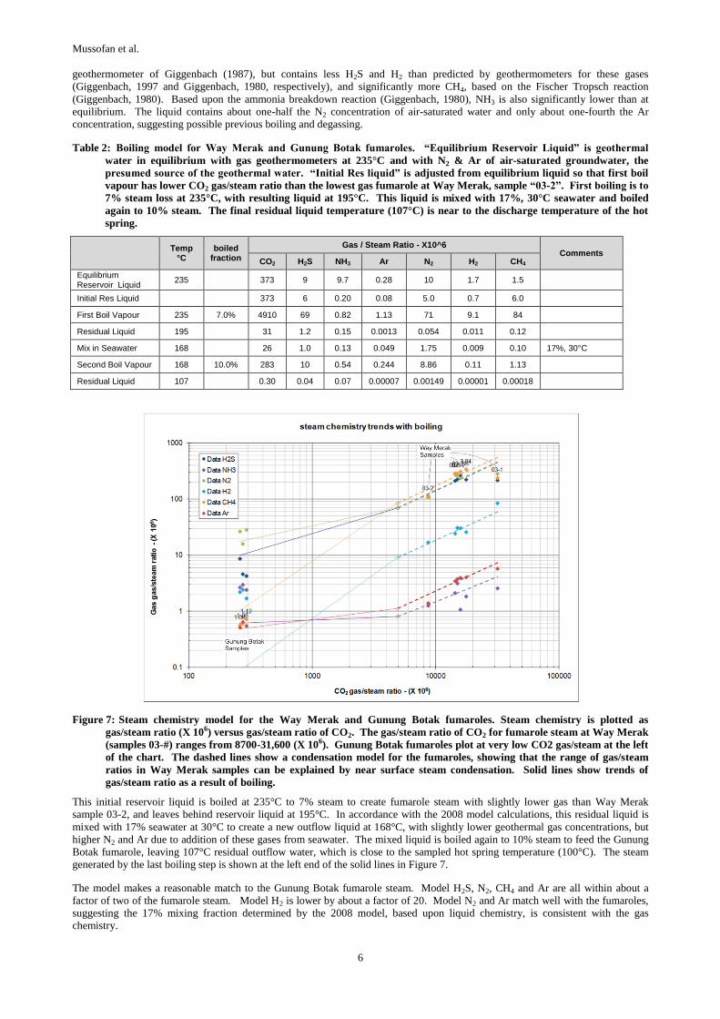
Mussofan et al.
6
geothermometer of Giggenbach (1987), but contains less H2S and H2 than predicted by geothermometers for these gases
(Giggenbach, 1997 and Giggenbach, 1980, respectively), and significantly more CH4, based on the Fischer Tropsch reaction
(Giggenbach, 1980). Based upon the ammonia breakdown reaction (Giggenbach, 1980), NH3 is also significantly lower than at
equilibrium. The liquid contains about one-half the N2 concentration of air-saturated water and only about one-fourth the Ar
concentration, suggesting possible previous boiling and degassing.
Table 2: Boiling model for Way Merak and Gunung Botak fumaroles. “Equilibrium Reservoir Liquid” is geothermal
water in equilibrium with gas geothermometers at 235°C and with N2 & Ar of air-saturated groundwater, the
presumed source of the geothermal water. “Initial Res liquid” is adjusted from equilibrium liquid so that first boil
vapour has lower CO2 gas/steam ratio than the lowest gas fumarole at Way Merak, sample “03-2”. First boiling is to
7% steam loss at 235°C, with resulting liquid at 195°C. This liquid is mixed with 17%, 30°C seawater and boiled
again to 10% steam. The final residual liquid temperature (107°C) is near to the discharge temperature of the hot
spring.
Temp
°C boiled
fraction
Gas / Steam Ratio - X10^6 Comments
CO2 H2S NH3 Ar N2 H2 CH4
Equilibrium Reservoir Liquid
235 373 9 9.7 0.28 10 1.7 1.5
Initial Res Liquid 373 6 0.20 0.08 5.0 0.7 6.0
First Boil Vapour 235 7.0% 4910 69 0.82 1.13 71 9.1 84
Residual Liquid 195 31 1.2 0.15 0.0013 0.054 0.011 0.12
Mix in Seawater 168 26 1.0 0.13 0.049 1.75 0.009 0.10 17%, 30°C
Second Boil Vapour 168 10.0% 283 10 0.54 0.244 8.86 0.11 1.13
Residual Liquid 107 0.30 0.04 0.07 0.00007 0.00149 0.00001 0.00018
Figure 7: Steam chemistry model for the Way Merak and Gunung Botak fumaroles. Steam chemistry is plotted as
gas/steam ratio (X 106) versus gas/steam ratio of CO2. The gas/steam ratio of CO2 for fumarole steam at Way Merak
(samples 03-#) ranges from 8700-31,600 (X 106). Gunung Botak fumaroles plot at very low CO2 gas/steam at the left
of the chart. The dashed lines show a condensation model for the fumaroles, showing that the range of gas/steam
ratios in Way Merak samples can be explained by near surface steam condensation. Solid lines show trends of
gas/steam ratio as a result of boiling.
This initial reservoir liquid is boiled at 235°C to 7% steam to create fumarole steam with slightly lower gas than Way Merak
sample 03-2, and leaves behind reservoir liquid at 195°C. In accordance with the 2008 model calculations, this residual liquid is
mixed with 17% seawater at 30°C to create a new outflow liquid at 168°C, with slightly lower geothermal gas concentrations, but
higher N2 and Ar due to addition of these gases from seawater. The mixed liquid is boiled again to 10% steam to feed the Gunung
Botak fumarole, leaving 107°C residual outflow water, which is close to the sampled hot spring temperature (100°C). The steam
generated by the last boiling step is shown at the left end of the solid lines in Figure 7.
The model makes a reasonable match to the Gunung Botak fumarole steam. Model H2S, N2, CH4 and Ar are all within about a
factor of two of the fumarole steam. Model H2 is lower by about a factor of 20. Model N2 and Ar match well with the fumaroles,
suggesting the 17% mixing fraction determined by the 2008 model, based upon liquid chemistry, is consistent with the gas
chemistry.

Mussofan et al.
7
The high H2 in the fumarole relative to the model may be due to regeneration of H2 in the outflow aquifer after first boiling.
Reservoir water in equilibrium with H2 at 195°C would contain H2 with a gas/steam ratio of 0.48 (X 10-6), which when mixed with
17% seawater and boiled to 10% steam would create steam with about 4.0 (X10-6), which is about twice what the Gunung Botak
fumaroles contain. It appears that H2 re-equilibration increased the H2 in the boiled liquid but did not go to completion.
It is not clear why the Gunung Botak fumaroles contain a factor of four more NH3 than the model. Although lower temperature
would favour the generation of NH3 from H2 and N2 by the reverse “ammonia breakdown” geothermometer reaction, equilibration
of this geothermometer appears to occur only at very high temperature (i.e. >300°C). Addition of organic NH3 is unlikely because
there is no similar enhancement of CH4 which would also form breakdown of organic material. Possibly, the high NH3 in the steam
may be due to reduction of natural nitric oxides introduced by the seawater mixing fraction.
In conclusion, the fumarole chemistry at Way Merak and Gunung Botak can be modelled as a geothermal outflow, as proposed by
the geothermal outflow model (2008).
3. CONCEPTUAL MODEL
The consistency of the gas depletion geochemical model with the boiling and seawater mixing model proposed in 2008 supports a
conceptual model for a liquid system at Rajabasa with the outflow from the system to the coastline. The outflow boils at Way
Merak and continues to flow to Gunung Botak (Figure 8). The intermediate seawater mixing step in the geochemical model for
Gunung Botak requires that the geothermal water enter the seawater pressure regime, so that it can mix with seawater. At the
195°C temperature of the geothermal water prior to mixing, the minimum depth of this mixing would be about 150m, although it is
possible that mixing and boiling occur concurrently at shallow depth. Even with shallow mixing, the implication is that geothermal
water is held to a depth below 150m up to the Gunung Botak springs, which places the geothermal aquifer below the Ghyben-
Herzburg surface and into the seawater pressure regime. Indications that the geothermal water crosses into the seawater pressure
regime supports the suggestion that much of the geothermal outflow may flow below the seabed beyond the coastline. This is
consistent with the continuation of the shallow conductor beyond the coastline observed in MT geophysics (Figure 8).
Figure 8: Conceptual model of a liquid geothermal system at Rajabasa.
REFERENCES
GeothermEx: Assessment of the Geothermal System at Rajabasa Sumatera, Indonesia; Internal Report to Supreme Energy
Rajabasa, (2008).
Giggenbach, W. F.: Geothermal Gas Equilibria; Geochem Cosmochem Acta, 44, (1980), 2021-2032.
Giggenbach, W.F.: Redox Processes Governing the Chemistry of Fumarolic Gas Discharges from White Island, New Zealand;
Applied Geochemistry, 2, (1987), 143-161.
Giggenbach, W.F.: The Origin and Evolution of Fluids in Magmatic-hydrothermal Systems, in Geochemistry of Hydrothermal Ore
Deposits, 3rd edition, H.L. Barnes ed., John Wiley & Sons, NY, June 1997.
Giggenbach, W.F., and Goguel, R.L.: Collection and Analysis of Geothermal and Volcanic Water and Gas Discharges; NZ DSIR
Chemistry Division report 2401, (1989).
SKM: The Chemistry of Geothermal Fluids; Internal Notes to Supreme Energy, (2011).
SKM: Review of Resource & Conceptual Model, Rajabasa Geothermal Field; Internal Report to Supreme Energy Rajabasa, (2012).
SKM: Surface Heat Loss from Rajabasa Geothermal Field; Internal Report to Supreme Energy Rajabasa, (2012).
Sugiaman F., Sunio E., Molling P., Stimac J.: Geochemical Response to Production of The Tiwi Geothermal Field, Philippines,
Geothermics, 33, (2004), 57-86.
White, S.P., Creighton A.L., Bixley, P.F., Kissling, W.M.: Modelling The Dewatering and Depressurization of the Lihir Open-pit
Gold Mine, Papua New Guinea, Geothermics, 33, (2004), 443-456.