geodetic and seismological analysis of the january 26th, 2014 cephalonia island earthquake sequence
TRANSCRIPT

Geodetic and seismological analysis of the January 26,2014 Cephalonia Island earthquake sequence.
D. Anastasiou1, G. Chouliaras2, X. Papanikolaou1, A. Marinou1,V. Zacharis1, J. Galanis1, G. Drakatos2, D. Paradissis1.
(1)Dionysos Satellite Observatory, National Technical University of Athenshttp://dionysos.survey.ntua.gr
(2)Institute of Geodynamics, National Observatory of Athenshttp://www.gein.noa.gr/en/

Tectonic Setting Seismicity Seismological Analysis Geodetic Network GPS Data analysis - Results Velocity Field Conclusions
Table of Contents
Tectonic Setting
Seismicity
Seismological Analysis
Geodetic Network
GPS Data analysis - Results
Velocity Field
Conclusions
2 / 22
AbstractOn January 26, 2014 a strong earthquake of magnitude Mw=5.8 occurred on Cephalonia
Island followed by a similar magnitude earthquake Mw=5.7 one week later on February 3,
2014. Extensive structural damages, landslides and many damages on the islandâĂŹs main
roads, harbour and airport caused mainly on the western and central part of the island.
The first event located 2km eastern of Lixouri town and was followed five hours later by a
strong aftershock of magnitude Mw=5.3. The second strong earthquake located in the
north part of Paliki eninsula (North-East Cephalonia). Geodetic data of six permanent
GNSS stations were available and analysed in this study both in pro and post seismic
terms, using 30sec and 1Hz data where available. The time series analysis shows the effect
of each event at nearby stations. Seismological data are used to determine the focal
mechanisms of the earthquake sequence and an attempt to investigate the homogeneity of
the mechanisms and the stress field of the area is presented in the study. Geodetic analysis
and seismological results are used to understand the mechanism of the events.

Tectonic Setting Seismicity Seismological Analysis Geodetic Network GPS Data analysis - Results Velocity Field Conclusions
Tectonic SettingCephalonia Island is located at the Ionian Sea
(Western Greece) and constitutes one of the most
active zones of shallow seismicity in the Eastern
Mediterranean area
All four types of plate boundary occur:
• Collision• Subduction• Transform• Spreading
[Sachpazi et. al., 2000] 3 / 22

Tectonic Setting Seismicity Seismological Analysis Geodetic Network GPS Data analysis - Results Velocity Field Conclusions
Seismicity in Greece
Seismicity in Greece from 1964 to 2015 with M>4 Region of Cephalonia Island
4 / 22

Tectonic Setting Seismicity Seismological Analysis Geodetic Network GPS Data analysis - Results Velocity Field Conclusions
Cephalonia Earthquakes 1953
The consequence of the complicated tectonicsetting is the production of extremely highseismicity and large, catastrophic earthquakes
The largest earthquake
August 12, 1953, M=7.3
one of the most destructive earthquakes in the
recent Greek history
5 / 22

Tectonic Setting Seismicity Seismological Analysis Geodetic Network GPS Data analysis - Results Velocity Field Conclusions
Disaster images
6 / 22

Tectonic Setting Seismicity Seismological Analysis Geodetic Network GPS Data analysis - Results Velocity Field Conclusions
Historical Focal Mechanisms1953 - 2013
Cephalonia focal Mechanisms from1953 to 201366 EventsM = 3.5 - 7
7 / 22

Tectonic Setting Seismicity Seismological Analysis Geodetic Network GPS Data analysis - Results Velocity Field Conclusions
2014 Earthquake Sequence
NOA-IG seismological stations1and focal mechanisms2of the 2014 seismic sequence
1http://www.gein.noa.gr/en/networks/other-networks/portable-seismic-network2http://bbnet.gein.noa.gr/HL/seismicity/moment-tensors
8 / 22

Tectonic Setting Seismicity Seismological Analysis Geodetic Network GPS Data analysis - Results Velocity Field Conclusions
Geodetic Network
l
StationName
Location Dist(km)
Inst Data
VLSM Valsamata,Cephalonia
18 NOA 30-s RINEX
KIPO Kipouria,Caphalonia
7 NOA 30-s RINEX; no dataduring the eq sequence
PONT Ponti,Lefkada
44 NOA 30-s RINEX
SPAN Spanochori,Lefkada
63 NOA 30-s RINEX
KEFA Lixouri,Cephalonia
7 Tree-Comp.CO
30-s and 1-s RINEX
LEUK Leukada 70 Tree-Comp.CO
30-s and 1-s RINEX;available only during thefirst eq
9 / 22

Tectonic Setting Seismicity Seismological Analysis Geodetic Network GPS Data analysis - Results Velocity Field Conclusions
Processing30s dataAll available data areroutinely processed viaBernese GNSS Softwarev5.2 [1].Each sub-network isprocessed twice:
• just a few hours afterthe end of day usingultra-rapid productsand
• after a time lag of 20days using finalproducts
Processing OptionsWe strive to keep our processing options and models in closeaccordance to the IGS1 analysis centers.
• Reference frame : follow IGS realization ⇒ currentlyIGb08 via three no-net-translation conditions imposedon a set of selected stations.
• Double-difference approach, ambiguities resolved tointegers (when possible); algorithm depends onbaseline length.
• Tropospheric mapping function : VMF1• Ionospheric information is either extracted from
CODE2 models, or from NTUA’s ultra-rapid solution.• Absolute antenna calibration model (current IGS .atx).• Sampling rate 30seconds, cut-off angle 7◦, iterative
residual check.
1Hz data• BKG Ntrip Client
(BNC)• Undifferenced 1Hz
carrier phase data• Broadcast corrections
for satellite orbits• Broadcast corrections
for satellite clocks
1International GNSS Service2Center for Orbit Determination in Europe
10 / 22

Tectonic Setting Seismicity Seismological Analysis Geodetic Network GPS Data analysis - Results Velocity Field Conclusions
Time SeriesDaily 30s data
11 / 22

Tectonic Setting Seismicity Seismological Analysis Geodetic Network GPS Data analysis - Results Velocity Field Conclusions
Time SeriesDaily 30s data
12 / 22

Tectonic Setting Seismicity Seismological Analysis Geodetic Network GPS Data analysis - Results Velocity Field Conclusions
January 26th, 2014Displacement of GPS Stations
Jun 26th
Station Solution dNorth dEast dUp(mm)
KEFAdailya -54.7 26.2 32.22-perb -47.8 21.7 24.5PPPc -47.0 25.0 -
VLSM dailya -7.8 -18.6 -9.82-perb -7.6 -19.6 -8.4
Table: co-seismic displacements for stations KEFA and VLSM
aDD, 30sec daily solutionbseperate the day of the event, prior to and after the earthquakecPPP-BNG 13 / 22

Tectonic Setting Seismicity Seismological Analysis Geodetic Network GPS Data analysis - Results Velocity Field Conclusions
January 26th, 20141Hz PPP Data Analysis - Station KEFA
Earthquake event: 13:55:42 (GPS Time)
seismic wave recorded: 13:56:05 (GPS Time) 23s delay
14 / 22
Tectonic Setting Seismicity Seismological Analysis Geodetic Network GPS Data analysis - Results Velocity Field Conclusions
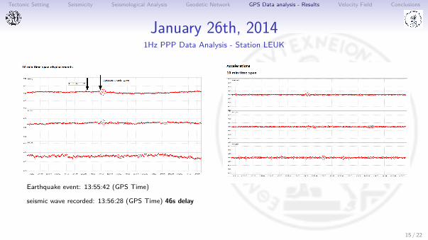
January 26th, 20141Hz PPP Data Analysis - Station LEUK
Earthquake event: 13:55:42 (GPS Time)
seismic wave recorded: 13:56:28 (GPS Time) 46s delay
15 / 22

Tectonic Setting Seismicity Seismological Analysis Geodetic Network GPS Data analysis - Results Velocity Field Conclusions
February 3rd, 2014Displacement of GPS Stations
Feb 3rd
Station Solution dNorth dEast dUp(mm)
KEFA dailya -91.0 31.0 33.0PPPb 200.0 0 80.0
VLSM dailya -9.0 -10.0 2.0
Table: co-seismic displacements for stations KEFA and VLSM
aDD, 30sec daily solutionbPPP-BNG
16 / 22
Tectonic Setting Seismicity Seismological Analysis Geodetic Network GPS Data analysis - Results Velocity Field Conclusions
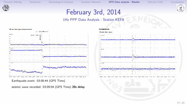
February 3rd, 20141Hz PPP Data Analysis - Station KEFA
Earthquake event: 03:08:44 (GPS Time)
seismic wave recorded: 03:09:04 (GPS Time) 20s delay
17 / 22

Tectonic Setting Seismicity Seismological Analysis Geodetic Network GPS Data analysis - Results Velocity Field Conclusions
Earthquake sequenceTotal Displacements for Both Earthquakes
Jan 26 - Feb 03
Station Solution dNorth dEast dUp(mm)
KEFA daily -147.0 60.0 65.0VLSM daily -17.0 -28.0 -8.0KIPO daily 70.0 -10.0 56.0
Table: co-seismic displacements for stations KEFA, VLSM and KIPO
18 / 22

Tectonic Setting Seismicity Seismological Analysis Geodetic Network GPS Data analysis - Results Velocity Field Conclusions
Velocity Field
CODE VN σVN VE σVE VU σVU
(mm/yr)KEFA -4.2 3.0 -6.19 2.0 2.48 3.0VLSM -6.77 4.0 -6.42 4.0 -0.54 4.0KIPO -1.99 3.0 -5.46 -2.0 1.39 2.0PONT -3.24 3.0 -3.2 5.0 -2.27 4.0SPAN -6.8 0.0 -2.5 0.0 -1.05 0.0LEUK -7.97 0.0 -2.86 0.0 -0.68 1.0
Table: Tectonic Velocities w.r.t. fixed Europe
19 / 22

Tectonic Setting Seismicity Seismological Analysis Geodetic Network GPS Data analysis - Results Velocity Field Conclusions
Conclusions I• Permanent displacements are only observed at stations KEFA, VLSM and KIPO.• Despite the significant seismic influence at stations KEFA, VLSM and KIPO, no
change of the tectonic movement can be observed.• The opposing movement in direction between KIPO and KEFA indicate that the
activated fault zone possibly lays between these two sites (Ganas et al., 2015).• Kinematic behavior of the stations is not affected.• Vertical offsets vary between -2 and 3 cm. Station KEFA and KIPO are uplifted, while
for VLSM a downshift of approximately 2 cm is evident.• PPP and DD approach result in the same conclusions for the offsets induced by the
first earthquake; this is not the case for the second earthquake.• Co-seismic displacements of GPS stations are in agreement with the focal mechanisms
of the earthquakes.• Stress field of the region, as shown by the analysis of the focal mechanisms of
historical earthquakes, is consistent with the velocity field derived from GPS data.
20 / 22

Tectonic Setting Seismicity Seismological Analysis Geodetic Network GPS Data analysis - Results Velocity Field Conclusions
Thank you very much for your attention !
21 / 22

Tectonic Setting Seismicity Seismological Analysis Geodetic Network GPS Data analysis - Results Velocity Field Conclusions
References I
Dach R., Hugentobler U., Fridez P., Meindl M.Bernese GPS Software Version 5.0Astronomical Institute, University of Bern, 2007.
Lekkas E., Mavroudis A., Karali K.Earthwuakes (Mw 6.0) of 26 Jan and 3 Feb 2014 a geodynamic episode in the evolution of Kefalonia island2014
Merryman Boncori J.P., Papoutsis I., Pezzo G., Tolomei C., Atzori S., Ganas A., Karastathis V., Salvi S., Kontoes C., Antonioli A.The February 2014 Cephalonia Earthquake (Greece): 3D Deformation Field and Source Modeling from Multiple SAR TechniquesSeismological Research Letters, Vol.86(1), 2015
P. RebischungIGb08: an update on IGS08IGSMAIL [6663] http://igscb.jpl.nasa.gov/pipermail/igsmail/2012/007853.html, 2012
Sachpazi, M. Hirn A., ClÃľment C., Haslinger F., Laigle M., Kissling E., Charvis P., Hello Y., LÃľpine J.-C., Sapin M.,Ansorge J.Hellenic subduction and Cephalonia Transform: local earthquakes and plate transport and strain.Tectonophysics, 319, 301-319, 2000.
Sakkas V., Lagios E.Fault modelling of the early-2014 ∼ M6 Earthquakes in Cephalonia Island (W. Greece) based on GPS measurementsTectonophysics, Volumes 644âĂŞ645,184-196, 2015, Pages 184-196
22 / 22