geoelectric and physiochemical evaluation of abuad ... · geoelectric and physiochemical evaluation...
TRANSCRIPT
International Journal of Scientific & Engineering Research, Volume 6, Issue 11, November-2015 1450 ISSN 2229-5518
IJSER © 2015 http://www.ijser.org
Geoelectric and Physiochemical Evaluation of ABUAD Groundwater Potential, Southwestern Nigeria
1* Ogundana, A.K , 2 Okunade A., 3 Aladesanmi A. O., 4Olutomilola O.O
,Department of Geology, Afe Babalola University, Ado-Ekiti.
ABSTRACT
A geoelectric and physiochemical evaluation of ABUAD groundwater potential was carried out to determine the quality of water in the boreholes in the school. A total of fourteen boreholes were investigated namely; borehole 1-14. Vertical electrical sounding (VES) using schlumberger electrode configuration was carried out to evaluate the groundwater potential of each of the boreholes (VES 1-14). Physiochemical tests were also carried out on the 14 boreholes to determine the quality of the water being produced. The electrical sounding conducted revealed that the study area has low to medium groundwater potential with clayey-sand, weathered and fractured basements constituting the aquiferous zones with an average depth range of 20-40m from the surface. Results of the physiochemical parameters revealed temperature ranges from 24.0-27.0 with average value of 24.00C. pH, TDS and EC revealed ranges of 6.3-7.7, 51.9-82.01mg/l, and 76.0-110.2μs/cm with the average values of 6.9, 68.7mg/l and 92.4μs/cm respectively. These parameters are well within WHO and NSDWO acceptable limits, however, the hydrochemical parameters need to be analysed. KEYWORDS: Geoelectric, Physiochemical, hydrochemical, Aquiferous unit.
I. INTRODUCTION
Groundwater exploration reports around Ado-Ekiti suggest low fracture in most part of this state capital. This results in low yield in most of the boreholes own by private individual and public.
Several workers such as Dutcher and Garret (1965), Clerk (1985), Olorunfemi and Olorunniwo (1985), Olorunfemi (1990), Olayinka and Olorunfemi (1992)Olorunfemi and Olayinka (1992), Olorunfemi and Fasuyi (1993), Oladipo et al, (2005) Olayinka and Weller (1993), Rehil and Birk (2010), Ojo et al, (2011), Talabi (2013) have carried research in various aspect of groundwater exploration/investigation, evaluation and structural delineation using geophysical methods in several location within the basement complex terrain around the world.
Afe Babalola University, Ado-Ekiti, is not just faced with the challenge of inadequate water supply to meet her ever increasing demand for potable water, the quality and sustainability of its groundwater potential is equally of great concern, hence the need to evaluate the existing borehole and establish the physio-chemical parameters of the groundwater. This study therefore aims at assessing the groundwater potential and the physio-chemical parameters of some of the existing wells within the University.
II. LOCATION AND GEOLOGY OF THE STUDY AREA 2.1 Location
Afe Babalola University is located in Ado-Ekiti along Ijan road, opposite The Federal Polytechnics. The study area is located within the University campus. The terain is gently undulating, with topographic elevation ranging from 345m to 370m above sea level. Ado Ekiti is underlain by crystalline rocks made of Older granite, Migmatite and Charnockites, with little or no fracture in most location and shallow overburden.
IJSER
International Journal of Scientific & Engineering Research, Volume 6, Issue 11, November-2015 1451 ISSN 2229-5518
IJSER © 2015 http://www.ijser.org
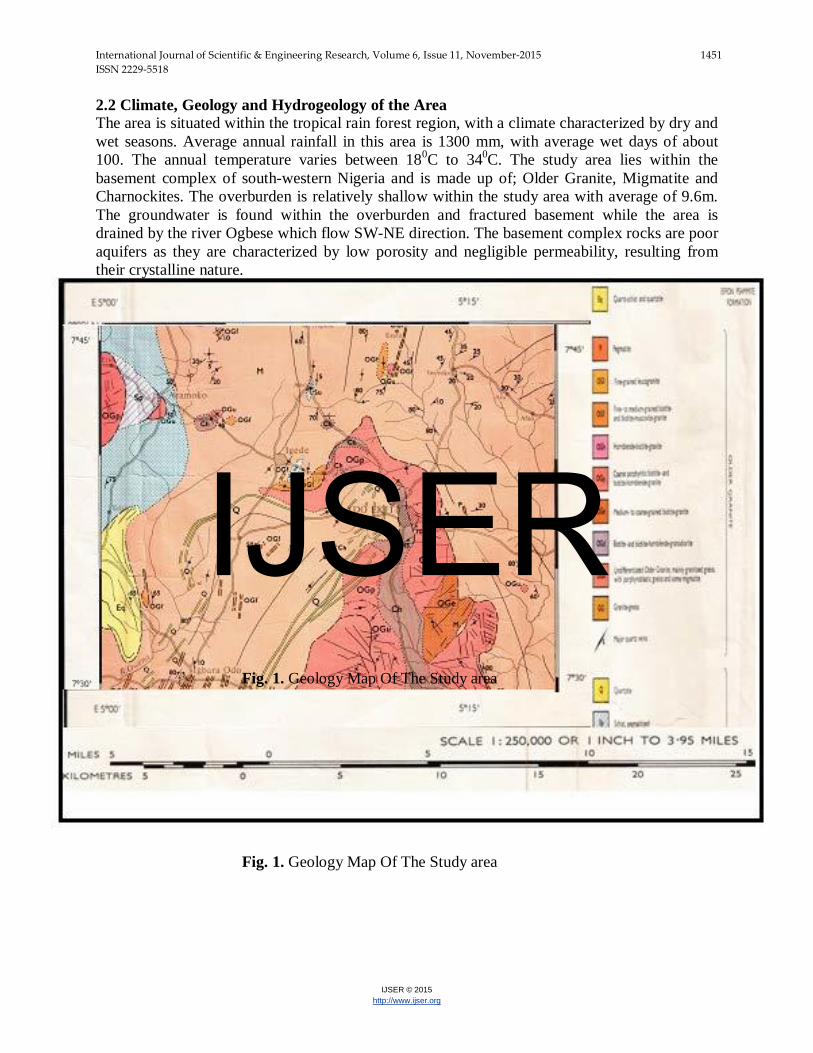
2.2 Climate, Geology and Hydrogeology of the Area The area is situated within the tropical rain forest region, with a climate characterized by dry and wet seasons. Average annual rainfall in this area is 1300 mm, with average wet days of about 100. The annual temperature varies between 180C to 340C. The study area lies within the basement complex of south-western Nigeria and is made up of; Older Granite, Migmatite and Charnockites. The overburden is relatively shallow within the study area with average of 9.6m. The groundwater is found within the overburden and fractured basement while the area is drained by the river Ogbese which flow SW-NE direction. The basement complex rocks are poor aquifers as they are characterized by low porosity and negligible permeability, resulting from their crystalline nature.
Fig. 1. Geology Map Of The Study area Fig. 1. Geology Map Of The Study area
IJSER
International Journal of Scientific & Engineering Research, Volume 6, Issue 11, November-2015 1452 ISSN 2229-5518
IJSER © 2015 http://www.ijser.org
III. Methodology, Data acquisition and Interpretation A reconnaissance survey of study area was carried out for site familiarization, planning and careful selection of wells for the study. A total of fourteen boreholes were investigated namely; boreholes 1 – 14. Corresponding vertical electrical soundings were conducted on each of the boreholes (VES 1 – 14). In situ physio-chemical alalysis parameters of the borehole water were taking. Physico-chemical parameters such as pH, temperature, electrical conductivity (EC), total dissolved (TDS) solids were determined on the field using portable multitestre meter. Water samples were taken for physiochemical analysis.
Resistivity sounding was adopted in resolving resistivity variation with depth, thus sounding helped in delineating the various subsurface lithological units, aquiferous layers and their hydrogeological significance.
IV. RESULTS AND DISCUSSIONS
4.1 RESULTS
A total of fourteen boreholes were investigated namely; boreholes 1 – 14. Corresponding vertical electrical soundings were conducted on each of the boreholes (VES 1 – 14). In situ physio-chemical alalysis parameters of the borehole water were taking.
4.1.1 SOUNDING SECTION
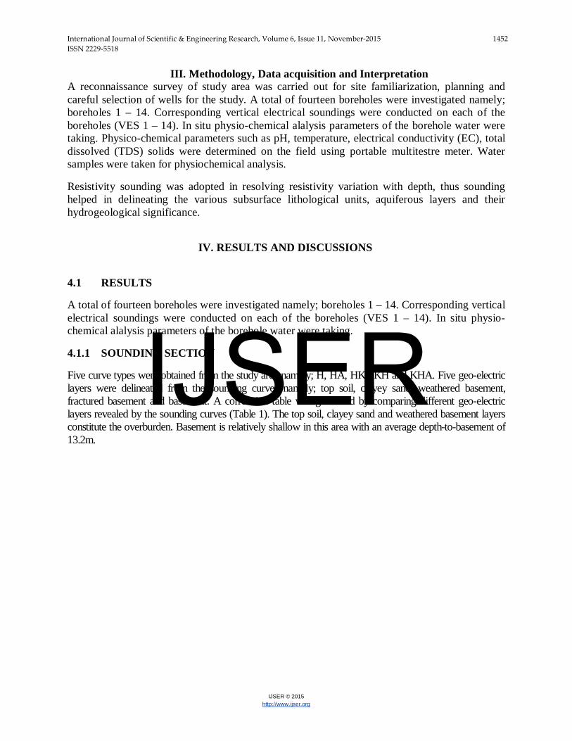
Five curve types were obtained from the study area namely; H, HA, HK, KH and KHA. Five geo-electric layers were delineated from the sounding curves namely; top soil, clayey sand, weathered basement, fractured basement and basement. A correlation table was generated by comparing different geo-electric layers revealed by the sounding curves (Table 1). The top soil, clayey sand and weathered basement layers constitute the overburden. Basement is relatively shallow in this area with an average depth-to-basement of 13.2m.
IJSER
International Journal of Scientific & Engineering Research, Volume 6, Issue 11, November-2015 1453 ISSN 2229-5518
IJSER © 2015 http://www.ijser.org
Fig. 2. Typical Geoelectric curves from the study area
IJSER

International Journal of Scientific & Engineering Research, Volume 6, Issue 11, November-2015 1454 ISSN 2229-5518
IJSER © 2015 http://www.ijser.org
Table 1a: Correlation Table
VES POINT 1 2 3 4 5 6 7
CURVE TYPE HA HA HA HA HK HA KHA
LITHOLOGY
TOP SOIL TOP 0.0 0.0 0.0 0.0 0.0 0.0 0.0
BASE 1.0 1.0 1.0 3.0 2.0 1.0 1.0
THICKNESS 1.0 1.0 1.0 3.0 2.0 1.0 1.0
Ωm 123 139 140 70 170 46 32
CLAYEY SAND
TOP 1.0 1.0 1.0 3.0 2.0 1.0 -
BASE 16.0 23.0 13.0 11.0 6.0 6.0 -
THICKNESS 15.0 22.0 12.0 8.0 4.0 5.0 -
Ωm 49 72 49 65 16 56 -
WEATHERED BASEMENT
TOP - 23.0 - - 6.0 6.0 1.0
BASE - - - - 19.0 - 4.0
THICKNESS - - - - 13.0 - 3.0
Ωm - 181 - - 339 114 217
FRACTURED BASEMENT
TOP - - - - 19.0 - 4.0
BASE - - - - - - 14.0
THICKNESS - - - - - - 10.0
Ωm - - - - 42 - 13
BASEMENT TOP 16.0 - 13.0 11.0 - - 14.0
Ωm 256 - 450 1042 - - 489
IJSER
International Journal of Scientific & Engineering Research, Volume 6, Issue 11, November-2015 1455 ISSN 2229-5518
IJSER © 2015 http://www.ijser.org
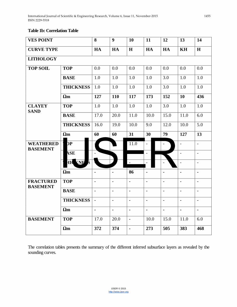
Table 1b: Correlation Table
VES POINT 8 9 10 11 12 13 14
CURVE TYPE HA HA H HA HA KH H
LITHOLOGY
TOP SOIL TOP 0.0 0.0 0.0 0.0 0.0 0.0 0.0
BASE 1.0 1.0 1.0 1.0 3.0 1.0 1.0
THICKNESS 1.0 1.0 1.0 1.0 3.0 1.0 1.0
Ωm 127 110 117 173 152 10 436
CLAYEY SAND
TOP 1.0 1.0 1.0 1.0 3.0 1.0 1.0
BASE 17.0 20.0 11.0 10.0 15.0 11.0 6.0
THICKNESS 16.0 19.0 10.0 9.0 12.0 10.0 5.0
Ωm 60 60 31 30 79 127 13
WEATHERED BASEMENT
TOP - - 11.0 - - - -
BASE - - - - - - -
THICKNESS - - - - - - -
Ωm - - 86 - - - -
FRACTURED BASEMENT
TOP - - - - - - -
BASE - - - - - - -
THICKNESS - - - - - - -
Ωm - - - - - - -
BASEMENT TOP 17.0 20.0 - 10.0 15.0 11.0 6.0
Ωm 372 374 - 273 505 383 468
The correlation tables presents the summary of the different inferred subsurface layers as revealed by the sounding curves.
IJSER
International Journal of Scientific & Engineering Research, Volume 6, Issue 11, November-2015 1456 ISSN 2229-5518
IJSER © 2015 http://www.ijser.org
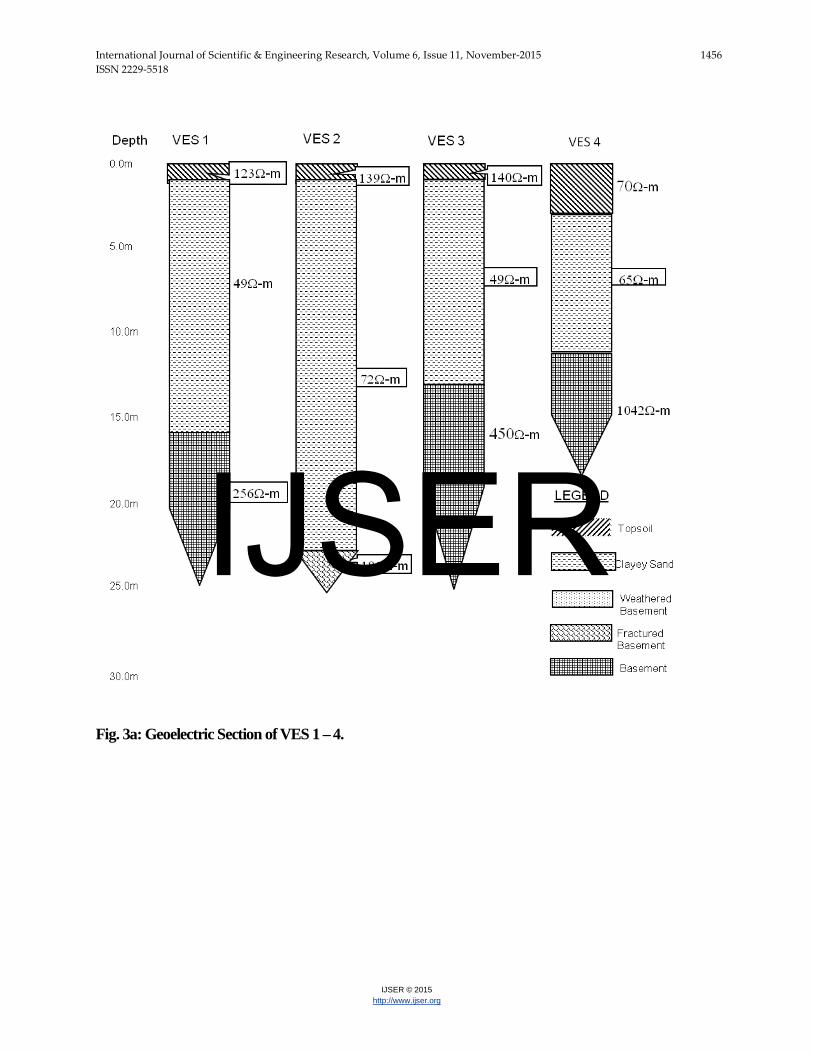
Fig. 3a: Geoelectric Section of VES 1 – 4.
IJSER
International Journal of Scientific & Engineering Research, Volume 6, Issue 11, November-2015 1457 ISSN 2229-5518
IJSER © 2015 http://www.ijser.org
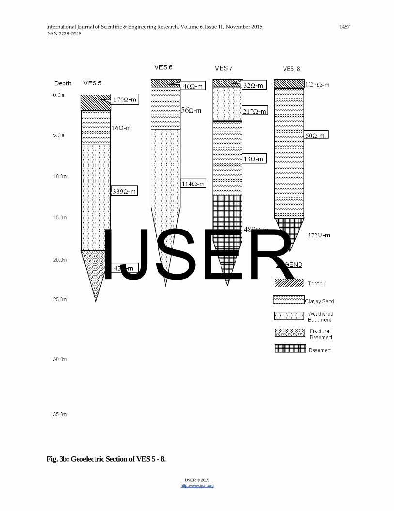
Fig. 3b: Geoelectric Section of VES 5 - 8.
IJSER
International Journal of Scientific & Engineering Research, Volume 6, Issue 11, November-2015 1458 ISSN 2229-5518
IJSER © 2015 http://www.ijser.org
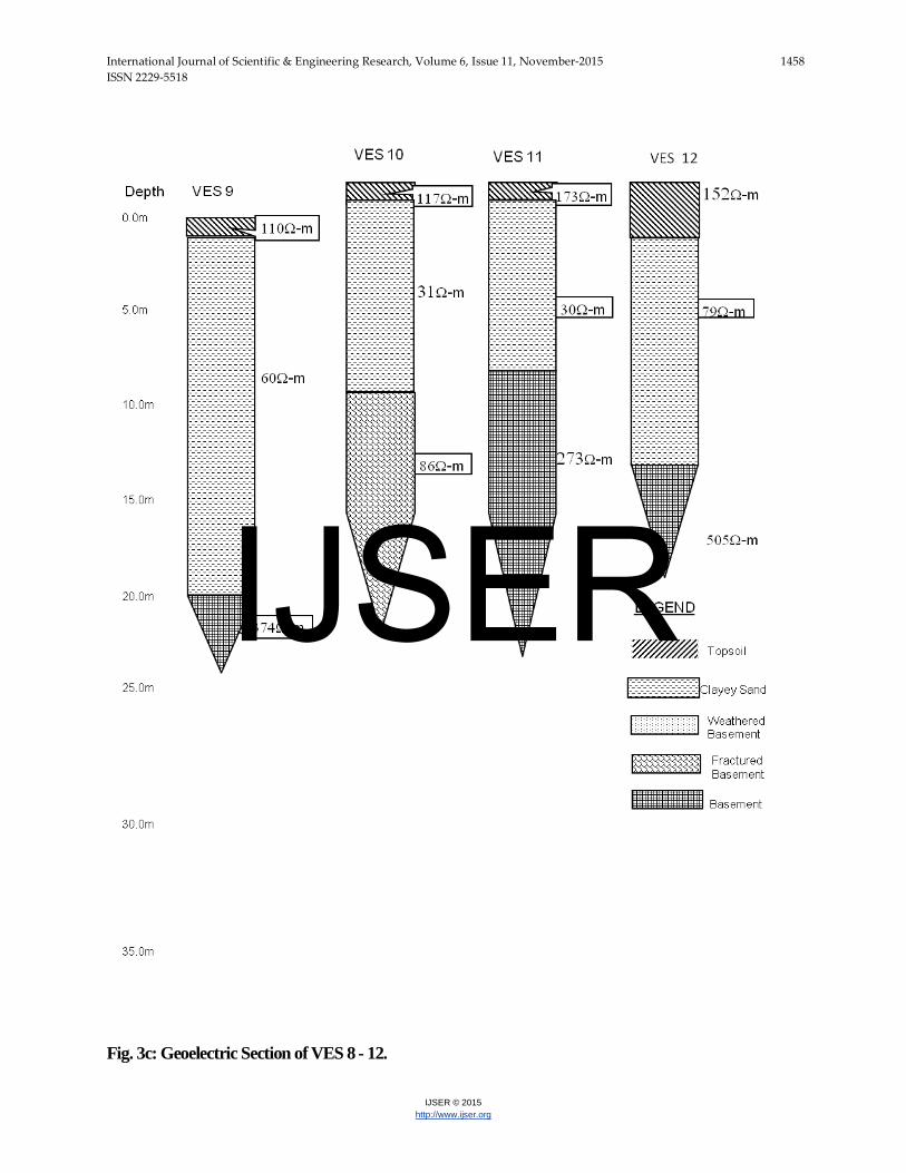
Fig. 3c: Geoelectric Section of VES 8 - 12.
IJSER
International Journal of Scientific & Engineering Research, Volume 6, Issue 11, November-2015 1459 ISSN 2229-5518
IJSER © 2015 http://www.ijser.org
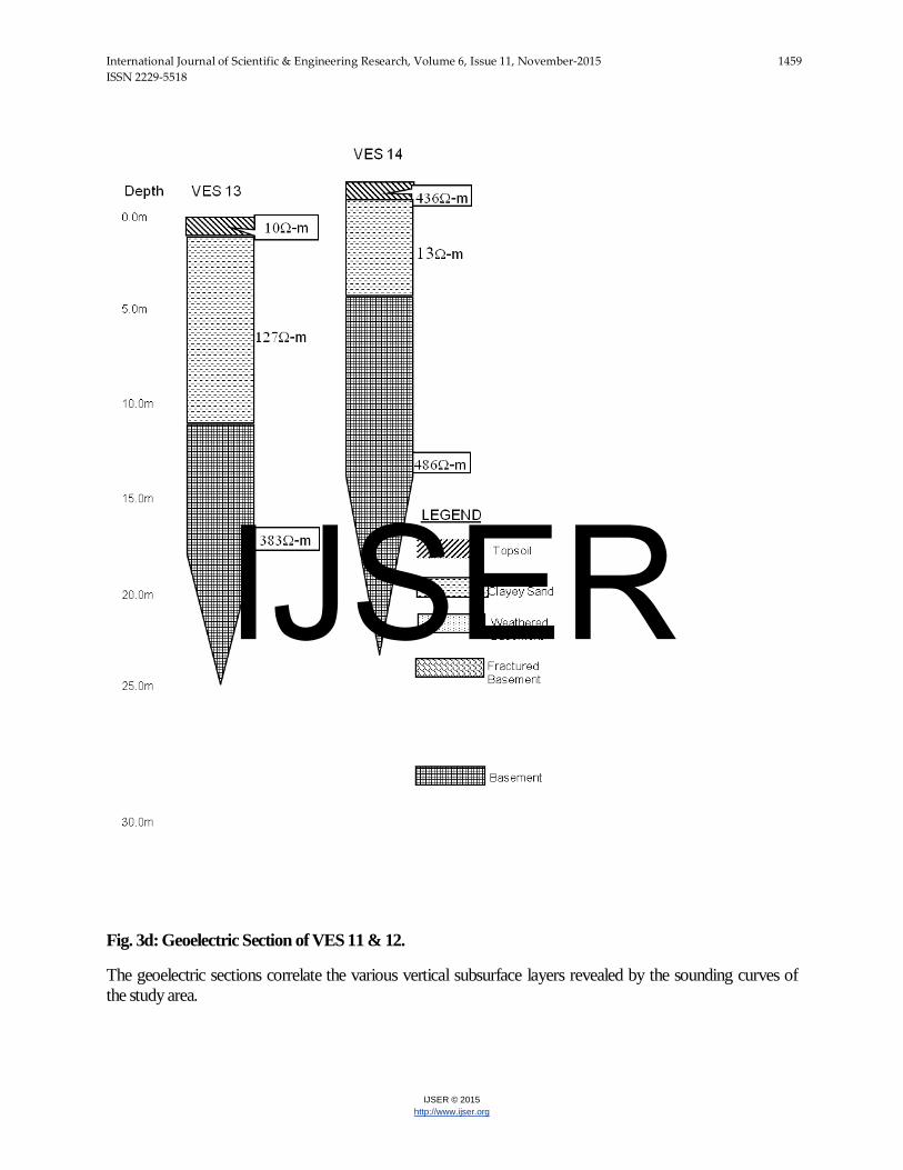
Fig. 3d: Geoelectric Section of VES 11 & 12.
The geoelectric sections correlate the various vertical subsurface layers revealed by the sounding curves of the study area.
IJSER
International Journal of Scientific & Engineering Research, Volume 6, Issue 11, November-2015 1460 ISSN 2229-5518
IJSER © 2015 http://www.ijser.org
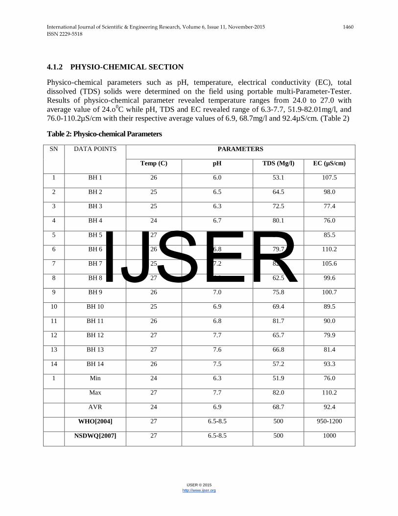
4.1.2 PHYSIO-CHEMICAL SECTION
Physico-chemical parameters such as pH, temperature, electrical conductivity (EC), total dissolved (TDS) solids were determined on the field using portable multi-Parameter-Tester. Results of physico-chemical parameter revealed temperature ranges from 24.0 to 27.0 with average value of 24.o0C while pH, TDS and EC revealed range of 6.3-7.7, 51.9-82.01mg/l, and 76.0-110.2µS/cm with their respective average values of 6.9, 68.7mg/l and 92.4µS/cm. (Table 2)
Table 2: Physico-chemical Parameters
SN DATA POINTS PARAMETERS
Temp (C) pH TDS (Mg/l) EC (µS/cm)
1 BH 1 26 6.0 53.1 107.5
2 BH 2 25 6.5 64.5 98.0
3 BH 3 25 6.3 72.5 77.4
4 BH 4 24 6.7 80.1 76.0
5 BH 5 27 7.0 51.9 85.5
6 BH 6 26 6.8 79.7 110.2
7 BH 7 25 7.2 82.0 105.6
8 BH 8 27 6.9 62.5 99.6
9 BH 9 26 7.0 75.8 100.7
10 BH 10 25 6.9 69.4 89.5
11 BH 11 26 6.8 81.7 90.0
12 BH 12 27 7.7 65.7 79.9
13 BH 13 27 7.6 66.8 81.4
14 BH 14 26 7.5 57.2 93.3
1 Min 24 6.3 51.9 76.0
Max 27 7.7 82.0 110.2
AVR 24 6.9 68.7 92.4
WHO[2004] 27 6.5-8.5 500 950-1200
NSDWQ[2007] 27 6.5-8.5 500 1000
IJSER
International Journal of Scientific & Engineering Research, Volume 6, Issue 11, November-2015 1461 ISSN 2229-5518
IJSER © 2015 http://www.ijser.org
4.2 DISCUSION Fourteen boreholes were investigated. The top soils are generally thin (within 0.4 – 3.1m, with the average of 2.5m) in most parts and the average apparent resistivity value is 131Ω-m while the clayey sand layers are relatively thick (within 4.0 – 22.1 m, with an average of 11.3m). The clayey sand average apparent resistivity value is very low (54Ω-m) across the study area. The combination of the top soil, clayey sand and weathered basement zones constitute the overburden units within the study area with an average thickness of 11.5m. The overburden materials and the fractured basement constitute the aquiferous units within the study area with low to medium groundwater potential (clayey sand units have low water yield and prone to caving, while fractured basement zones have medium groundwater potential). The physio-chemical parameters obtained from the boreholes are all within both WHO and NSDWO acceptable limits (Table 4.2) 4.3 RECOMMENDATIONS Given the thick and unconsolidated nature of the overburden material in the study area, proper completion should be ensured in order to avoid caving and other formation problems. Air drilling should be discouraged and adequate, right mixture of drilling mud should be applied to secure the hole wall while flushing should be continuous throughout drilling in such formation. Casing should be done immediately while drilled holes should be lined and properly grouted. Timers should be installed on low yield wells and regulated/programmed for 5 minutes flow and 10 minutes recharge as the case may be. Productive wells should be properly maintained and monitored for optimal performance. Hydrochemical analysis of water samples from the boreholes should be conducted since the aquiferous layers are porous and susceptible to pollution. 4.4 CONCLUSION
Afe Babalola University Ado-Ekiti has low to medium groundwater potential with clayey sand, weathered and fractured basements constituting the aquiferous zones within an average depth range of 20 – 40m from the surface. The physio-chemical parameters of the wells within the study area are within WHO and NSDWO acceptable limits, however, the hydrochemical parameters need to be analysed.
References
Clerk L (1985). Groundwater Abstraction from Basement Complex Areas of Africa. J. Eng. Geol., London 18: 25-34.
Dutcher, L.C. and Garrett. A.A., 1963, Geologic and hydrologic features of the San Bernardino area , Califonia: U.S.Geological survey Water-Supply Paper 1419, 114p.
Oladipo, A. A., Oluyemi, E. A., Tubosun, I. A., Fasisi, M. K. and Ibitoye, F. I, Chemical Examination of Ikogosi Warm Spring in South Western Nigeria. Journal of Applied Sciences, 2005, 5 (1): 75-79
IJSER
International Journal of Scientific & Engineering Research, Volume 6, Issue 11, November-2015 1462 ISSN 2229-5518
IJSER © 2015 http://www.ijser.org
Olayinka A. I. and Weller A. 1997. The inversion of geoelectrical data for hydrogeological applications in crystalline basement areas of Nigeria. Journ. of Applied Geosciences, Vol. 37, Issue 2, June 1997, pp 103 – 105.
Olayinka AI, Olorunfemi MO (1992). Determination of geoelectrical Characteristic in Okene Area and implication for boreholes setting. J. Min. Geol., 28: 403 - 412.
Ojo, J.S., Olorunfemi, M.O. and Falebita, D.E, An Appraisal of the Geologic Structure beneath the Ikogosi Warm Spring in South- Western Nigeria Using Integrated Surface Geophysical Methods. Earth Sciences Research Journal. 2011, 15(1):27-34.
Olorunfemi MO, Fasuyi SA (1993). Aqufier types and geoelectric/hydrogeologic characteristics of part of central basement terrain of Nigeria (Niger State). J. Africa Earth Sci., 16(3): 309-317.
Olorunfemi M. D. & Olayinka A. I. (1992): Alteration of Geoelectric in Okene are and Implication for Borehole Sitting. Journal of Mining and Geology, pp. 403-411.
Olorunfemi M. O. (1990): The Hydrogeological Implication of Topographic Variation with Overburden Thickness in Basement Complex. Area of South Western Nigeria. Journal of Mining and Geology. Vol 26, No. 1.
Olorunfemi M. O. & Oloruniwo M. A. (1985): Geoelectric Parameters and Aquifer Characteristics of Some Part of South Western Nigeria. Journal of Mining and Geology.
Olorunfemi MO, Olorunniwo MA (1985). Parameters and aquifer characteristics of some parts of SW. Nigeria Geologic Applica E. Hydrogeological, XX Part 1, pp. 99-109.
Rehrl, C. and Birk, S. 2010, Hydrogeological Characterisation and Modelling of Spring Catchments in a Changing Environment. Austrian Journal of Earth Sciences Volume 103 Issue 2, p106-117 Vienna.
Talabi, A. O., 2013, Hydrogeochemistry and Stable Isotopes (δ18O and δ2H) Assessment of
Ikogosi Spring Waters. American Journal of Water Resources, 2013, Vol. 1, No. 3, 25-33.
IJSER