geographical characteristics and the components at risk of tornado in rural bangladesh a case study...
DESCRIPTION
Tornado, Bangladesh, Rezwan Siddiqui, Brammhanbariahttp://www.omicsgroup.org/journals/Geographical-Characteristics-and-the-Components-at-Risk-of-Tornado-in-Rural-Bangladesh-A-Case-Study-of-Brahmanbaria-Tornado-2167-0587.1000111.pdfTRANSCRIPT
7/18/2019 Geographical Characteristics and the Components at Risk of Tornado in Rural Bangladesh a Case Study of Brahm…
http://slidepdf.com/reader/full/geographical-characteristics-and-the-components-at-risk-of-tornado-in-rural 1/4
Taslima Hossain.
and Environment, University of Dhaka. E-mail: [email protected]
Md Rezwan Siddiqui, Department of Geography
Department of Geography and Environment, University of Dhaka
Research Article Open Access
Volume 3 • Issue 2 • 1000111J Geogr Nat Disast
ISSN: 2167-0587 JGND, an open access journal
Open AccessCase Report
Geography & Natural DisastersSiddiqui and Hossain, J Geogr Nat Disast 2013, 3:2
http://dx.doi.org/10.4172/2167-0587.1000111
*Corresponding authors:
Received July 23, 2013; Accepted August 29, 2013; Published September 04,
2013
Citation: Siddiqui MR, Hossain T (2013) Geographical Characteristics and the
Components at Risk of Tornado in Rural Bangladesh: A Case Study of Brahmanaria
Tornado. J Geogr Nat Disast 3: 111. doi:10.4172/2167-0587.1000111
Copyright: © 2013 Siddiqui MR, et al. This is an open-access article distributedunder the terms of the Creative Commons Attribution License, which permits
unrestricted use, distribution, and reproduction in any medium, provided the
original author and source are credited.
Geographical Characteristics and the Components at Risk of Tornado in
Rural Bangladesh: A Case Study of Brahmanaria TornadoMdRezwan Siddiqui* and Taslima Hossain*
Abstract
On 22 March 2013, a tornado swept over the Brahmanaria and Akhura Sadar Upazila (sub-district) of Brahmanaria
district in Chittagong Division of Bangladesh and caused 35 deaths. There were also high levels of property damages.
The aim of this paper is to present the geographical characteristics of Brahmanaria tornado and the detail of damages
it has done. Through this we will assess the components at risk of tornado in the context of rural Bangladesh. Research
shows that, though small in nature and size, Brahmanaria tornado was very much catastrophic – mainly due to the lack
of awareness about this natural phenomenon. This tornado lasts for about 15 minutes and traveled a distance of 12
kilometer with an area of inuence of 1 square kilometer of area. Poor and unplanned construction of houses and other
infrastructures was also responsible for 35 deaths, as these constructions were unable to give any kind of protection
during tornado. From this research, it has been seen that human life, poultry and livestock are mostly at risk of tornadoesin case of rural Bangladesh. Inhabitants of this region are completely unaware of the life and property saving measures
necessary to take during tornado. This tornado caused high level of human death and casualties and it will take a long
time for the affected to overcome the losses.
Keywords: ornado; Risk; Characteristics; Bangladesh; Brahmanaria
Objective
Key objective o this research is to understand the geographical
characteristics o a tornado in Bangladesh. In Bangladesh, there are
several tornadoes in different parts o the country. But or the lack o
proper source o data and identification system, they remain unnoticed
most o the time. Te country has no tornado warning system, nor any
tracking or measurement system o tornado. As a result, no effort canbe taken to assess the elements at risk o tornado or the country, or
the lack o proper data.
A tornado database was developed by Jonathon Finch in 1996
which was highly generalized and lack o detail inormation about each
tornado in Bangladesh. So, a research like this is hoped to develop a
new way to learn about the tornado in context o Bangladesh [1].
Introduction
Many parts o Bangladesh are regarded as high risk zone or tornado.
During 1961-1996 local newspapers reported 10,766 tornado deaths.
During the thirty five-year period, twenty o 199 tornadoes killed more
than 100 people and seven o them killed more than 500 people [1]. Onan average 179 people dies every year tornado in Bangladesh [2]; most
o which become unnoticed because o highly localized in nature.
A violent tornado swept over the eastern part o Bangladesh in
Brahmanbaria Sadar Upazila (sub-district) and AkhauraUpazila (sub-
district) o Brahmanaria Districts on 22nd March 2013. Te incident
occurred around 17:10 hours in local time (GM +6) and lasts or 15
minutes [3].
Te most significant eature o this tornado is there was no past
record o any tornadoes in Brahmanaria or surrounding areas [1,3].
As a result people o this area didn’t know about the characteristics o
the tornado and the necessary measure to save their lie and properties.
Te target o this research is to find out the geographicalcharacteristics o the tornado in Bangladesh also point out the elements
at risk o tornado in the perspective o rural Bangladesh.
Methodology
Te research has done with the combination o two methods.
An immediate field visit and survey to the tornado affected villages
was done on 26 March, 2013 by the researcher and his team. Several
interviews were taken to understand experience o the affected people,
to find out the elements at risks and also the nature o damages done
by the tornado.
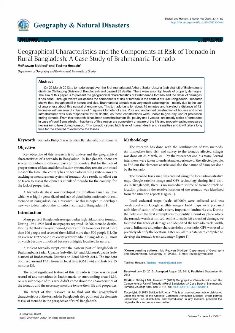
Te tornado track map was created using the local administrativemap, Google satellite image and GPS technology during field visit.
As in Bangladesh, there is no immediate source o tornado track or
location primarily the relative location o the tornado was identified
rom the situation reports (Figure 1).
Local cadastral maps (scale 1:50000) were collected and was
overlapped with Google satellite images. Field maps were prepared
with identification o roads, rivers, important landmarks etc. During
the field visit the first attempt was to identiy a point or place where
the tornado was first noticed. As the tornado lef a track o damage, we
ollowed this track o damage and identified the tornado track, width,
area o influence and other characteristics o tornado. GPS was used to
precisely identiy the location. Later on, all this data were compiled todevelop the tornado track and map (Figure 1).
7/18/2019 Geographical Characteristics and the Components at Risk of Tornado in Rural Bangladesh a Case Study of Brahm…
http://slidepdf.com/reader/full/geographical-characteristics-and-the-components-at-risk-of-tornado-in-rural 2/4
Citation: Siddiqui MR, Hossain T (2013) Geographical Characteristics and the Components at Risk of Tornado in Rural Bangladesh: A Case Study
of Brahmanaria Tornado. J Geogr Nat Disast 3: 111. doi:10.4172/2167-0587.1000111
Page 2 of 4
Volume 3 • Issue 2 • 1000111J Geogr Nat Disast
ISSN: 2167-0587 JGND, an open access journal
Newspaper reports, situation reports by the government anddifferent NGO’s were collected and analysed to get the actual figure odamages and relie acilities done afer the tornado. From the analysiso damage data, and the field survey the elements at risks o tornadowere identified.
Results and Discussion
Geographical coverage
Te tornado travels a distance o more than 12 kilometer. Tetornado begins at Ram rail Village o Ram rail Union and ended atAhmedabad Village o North Akhaura Union. Te identified villages
over which tornado traveled are listed in able 1. Among them Dublais damaged most severely ollowed by Fulbaria and Chinnari amongthirteen villages o six unions reported to be visited by this tornado.
As observed rom the field survey, the average radius o thetornado on earth surace was sixty to eighty meter. It affected an area oseventeen square kilometer [3], o which around one square kilometerarea was heavily damaged. Anything within this area was devastated.Almost ninety percent o the causalities occurred within this area oinfluence o the tornado.
Meteorological condition
Te regional meteorological condition o affected area on thetornado day (22 March, 2013) and during the tornado is in able 2. It
was definitely very high temperature on that day o tornado occurrence.At noon the average temperature o that area is more than 35°C and itcreates the perect triggering actor or tornado.
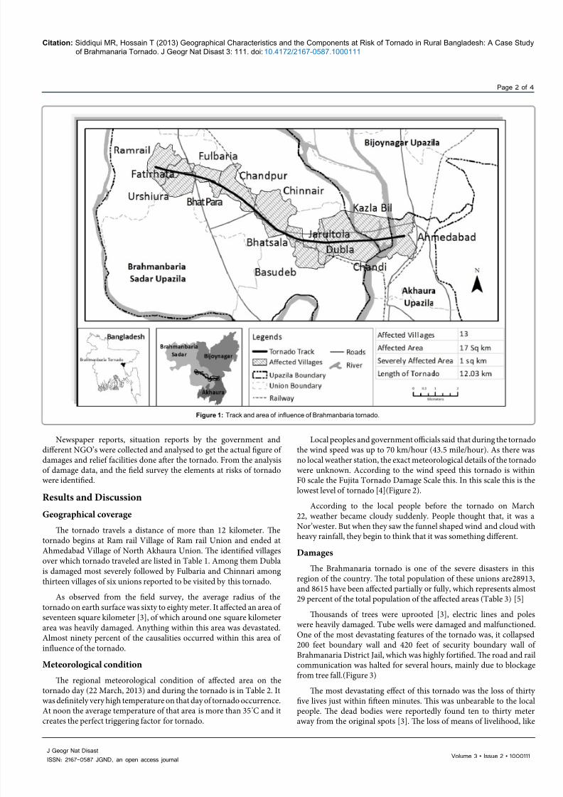
Local peoples and government officials said that during the tornadothe wind speed was up to 70 km/hour (43.5 mile/hour). As there wasno local weather station, the exact meteorological details o the tornadowere unknown. According to the wind speed this tornado is withinF0 scale the Fujita ornado Damage Scale this. In this scale this is thelowest level o tornado [4](Figure 2).
According to the local people beore the tornado on March22, weather became cloudy suddenly. People thought that, it was aNor’wester. But when they saw the unnel shaped wind and cloud withheavy rainall, they begin to think that it was something different.
Damages
Te Brahmanaria tornado is one o the severe disasters in thisregion o the country. Te total population o these unions are28913,and 8615 have been affected partially or ully, which represents almost29 percent o the total population o the affected areas (able 3) [5]
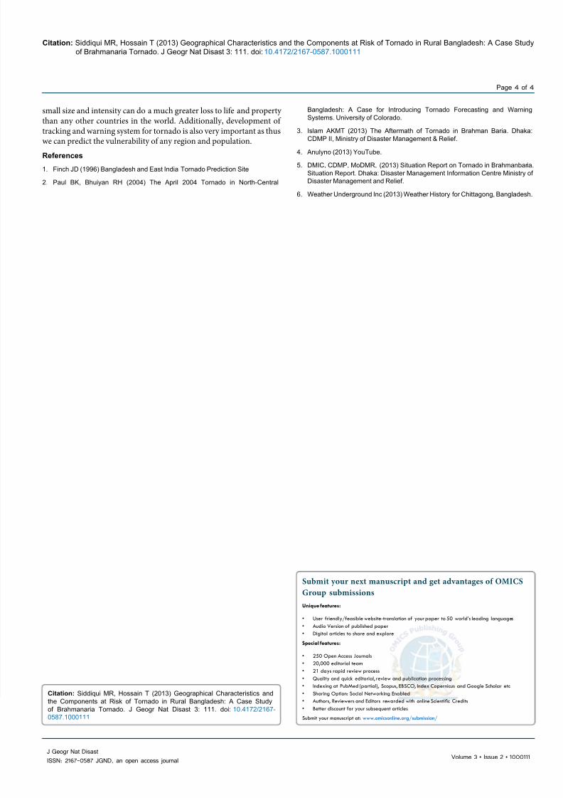
Tousands o trees were uprooted [3], electric lines and poleswere heavily damaged. ube wells were damaged and malunctioned.One o the most devastating eatures o the tornado was, it collapsed200 eet boundary wall and 420 eet o security boundary wall oBrahmanaria District Jail, which was highly ortified. Te road and railcommunication was halted or several hours, mainly due to blockagerom tree all.(Figure 3)
Te most devastating effect o this tornado was the loss o thirty
five lives just within fifeen minutes. Tis was unbearable to the localpeople. Te dead bodies were reportedly ound ten to thirty meteraway rom the original spots [3]. Te loss o means o livelihood, like
Figure 1: Track and area of inuence of Brahmanbaria tornado.

7/18/2019 Geographical Characteristics and the Components at Risk of Tornado in Rural Bangladesh a Case Study of Brahm…
http://slidepdf.com/reader/full/geographical-characteristics-and-the-components-at-risk-of-tornado-in-rural 3/4
Citation: Siddiqui MR, Hossain T (2013) Geographical Characteristics and the Components at Risk of Tornado in Rural Bangladesh: A Case Study
of Brahmanaria Tornado. J Geogr Nat Disast 3: 111. doi:10.4172/2167-0587.1000111
Page 3 of 4
Volume 3 • Issue 2 • 1000111J Geogr Nat Disast
ISSN: 2167-0587 JGND, an open access journal
crops and livestock or poultry brought urther havoc to their miseries.
Tese created a long lasting economic problem or the affected people.
Almost 1300 livestock and poultry died in this tornado, which are amajor source o income o people living in those villages.
In this area, the tin made houses were abandoned which was
completely destroyed. Te roos were blown away, wall collapsed;home urniture and utensils were flown away to a urther distance. Tebrick built buildings were not spared. Most o the brick built houses
within the tornado track collapsed partially or ully, causing casualties.Te reason behind this is mainly poor construction.
Elements at risks
Te Brahmanaria tornado caused heavy atal damages to human and
animal lie considering its small geographic nature and less intensity.
Tis is because o the completely unawareness o the population about
the tornado and the necessary measures to save lie rom tornado. I
those populations were aware o this natural hazard, such devastating
atalities would never happen. Tis kind o unawareness about tornado
is very much common in rural Bangladesh. So, human lie is top
element at risk o tornado in rural Bangladesh [6].
Loss o more than a thousand household livestock and poultry
is a massive economic loss or a rural area in Bangladesh. Peoples
livelihood and nutrition supply are dependent on these. So, these are
another most highly risked element or tornado in rural Bangladesh.
Te houses were mainly teen shaded with wood and tin wall. Tere
were many brick built houses also. But all these houses were poorly
contrasted. Even the brick built houses were devastated by the tornado
–as they were not tornado resilient in any way. Moreover there were
no underground chambers o houses to take shelter during tornado. So
taking shelter within the houses did not help anyone rom not getting
injured or killed.
Electricity supply was great hampered by the tornado, as the polls
were weak not tornado resistant.
From the field interviews and surveys, we can list ollowing items
as at risk o tornado:
1. People without awareness about what to do during tornado.
Especially women and children
2. Livestock and poultry are heavily at risks
3. All types o houses and other structures like mosques, schools
etc.; as those are very poorly constructed.
4. Electricity, telephone and water services are also vulnerable.
Conclusion
Tere is a need o an extensive research to find out the adaptation
strategies or tornado in the context o rural Bangladesh. Bangladeshis a densely populated country and or this reason any tornado with
Brahmanbaria District, Chittagong Division, Bangladesh
Upazila Union Village(s)
Brahmanbaria Sadar
Ramrail Ramrail
Sultanpur Fatirhata, Urshiura
Machihata Fulbaria, Chandpur, Chinnari
BashudebBhatsala, Basudeb, Jarultola, Dubla,
Chandi
Bijoynagar Pattan KazlaBil
Akhaura North Akhaura Ahmedabad
( Field Survey, 2013), (DMIC, CDMP, MoDMR, 2013)
Table 1: Affected villages of Brahmanbaria Tornado.
Time (BDT)Tempera
ture
Heat
IndexHumidity Pressure
Wind Wind
SpeedDirection
Average of
26.0 °C 32.45 °C 83% 1007.29 hPa 13.7 km/hthe Day (22
March, 2013)
16:50:00 hours 28.0 °C 31.9 °C 79% 1005 hPa SW 14.8 km/h17:50:00 hours 28.0 °C 32.7 °C 84% 1006 hPa South 13.0 km/h
Source: (Weather Underground, Inc., 2013)
Table 2: Meteorological condition of the affected area on 22nd March, 2013.
Figure 2: The Brahmanbaria Tornado. Source: YouTube video [4].
Figure 3: Damages done by the Brahmanbaria tornado.
Sector of Damage Number
Deaths 35
Injured 388
Affected FamiliesHeavily 1,326
Partially 402
Destroyed HousesFully 2,635
Partially 752
Affected PeoplesFully 6,630
Partially 1,985
Affected Crops (Acre)Fully 173
Partially 1,112
Affected Educational
Institutions 6
Affected Religious Institutions 5
Affected Road (km) 2.25
Livestock Death 299
Poultry Death 910
(DMIC, CDMP, MoDMR, 2013)(Islam, 2013)
Table 3: Damages done by Brahmanbaria Tornado.
7/18/2019 Geographical Characteristics and the Components at Risk of Tornado in Rural Bangladesh a Case Study of Brahm…
http://slidepdf.com/reader/full/geographical-characteristics-and-the-components-at-risk-of-tornado-in-rural 4/4
Citation: Siddiqui MR, Hossain T (2013) Geographical Characteristics and the Components at Risk of Tornado in Rural Bangladesh: A Case Study
of Brahmanaria Tornado. J Geogr Nat Disast 3: 111. doi:10.4172/2167-0587.1000111
Page 4 of 4
Volume 3 • Issue 2 • 1000111J Geogr Nat Disast
ISSN: 2167-0587 JGND, an open access journal
small size and intensity can do a much greater loss to lie and propertythan any other countries in the world. Additionally, development otracking and warning system or tornado is also very important as thus
we can predict the vulnerability o any region and population.
References
1. Finch JD (1996) Bangladesh and East India Tornado Prediction Site
2. Paul BK, Bhuiyan RH (2004) The April 2004 Tornado in North-Central
Bangladesh: A Case for Introducing Tornado Forecasting and Warning
Systems. University of Colorado.
3. Islam AKMT (2013) The Aftermath of Tornado in Brahman Baria. Dhaka:
CDMP II, Ministry of Disaster Management & Relief.
4. Anulyno (2013) YouTube.
5. DMIC, CDMP, MoDMR, (2013) Situation Report on Tornado in Brahmanbaria.
Situation Report. Dhaka: Disaster Management Information Centre Ministry of
Disaster Management and Relief.
6. Weather Underground Inc (2013) Weather History for Chittagong, Bangladesh.
Submit your next manuscript and get advantages of OMICS
Group submissions
Unique features:
• User friendly/feasible website-translation of your paper to 50 world’s leading languages
• Audio Version of published paper
• Digital articles to share and explore
Special features:
• 250 Open Access Journals
• 20,000 editorial team
• 21 days rapid review process
• Quality and quick editorial, review and publication processing
• Indexing at PubMed (partial), Scopus, EBSCO, Index Copernicus and Google Scholar etc
• Sharing Option: Social Networking Enabled
• Authors, Reviewers and Editors rewarded with online Scientic Credits
• Better discount for your subsequent articles
Submit your manuscript at: www.omicsonline.org/submission/
Citation: Siddiqui MR, Hossain T (2013) Geographical Characteristics and
the Components at Risk of Tornado in Rural Bangladesh: A Case Studyof Brahmanaria Tornado. J Geogr Nat Disast 3: 111. doi:10.4172/2167-
0587.1000111