geographix 2017.1 release notes
TRANSCRIPT
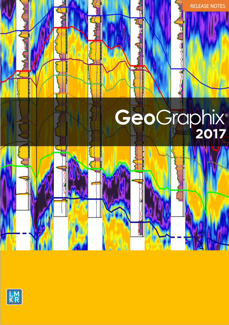
RELEASE NOTES
© 2001 - 2017 Landmark Graphics Corporation. All Rights Reserved.
This publication has been provided pursuant to an agreement containing restrictions on its use. The publication is also protected by Federal copyright law. No part of this publication may be copied or distributed, transmitted, transcribed, stored in a retrieval system, or translated into any human or computer language, in any form or by any means, electronic, magnetic, manual, or otherwise, or
disclosed to third parties without the express written permission of:
Landmark Graphics Corporation Building 1, Suite 200, 2101 CityWest, Houston, Texas 77042, USA
P.O. Box 42806, Houston, Texas 77242, USA Phone: 713-839-2000
Help desk: 713-839-2200 FAX: 713-839-2401
Internet: www.lgc.com
AND
LMKR Holdings Corporate Headquarters
Unit No. B1501, Latifa Tower, Sheikh Zayed Road,
Dubai, UAE, P.O.Box 62163. Phone: +971 4 372 7900
FAX: +971 4 358 6386 Internet: www.lmkr.com
Trademark Notice
DecisionSpace, Discovery, GeoGraphix (stylized), GeoGraphix Exploration System, GeoLink, GES, GESXplorer, GMAplus, IsoMap, LeaseMap, LogM, OpenWorks, OpenWorks Well File, PRIZM,
SeisVision, Xsection are trademarks, registered trademarks or service marks of Landmark Graphics Corporation.
All other trademarks are the property of their respective owners.
Note
The information contained in this document is subject to change without notice and should not be construed as a commitment by LMKR. LMKR assumes no responsibility for any error that may appear in this manual. Some states or jurisdictions do not allow disclaimer of expressed or implied warranties in
certain transactions; therefore, this statement may not apply to you.
GeoGraphix® 2017.1 Release Notes i
Contents
GeoGraphix® and Discovery™ on OpenWorks® 2017.1 ................................................................................ 1
New Features at a Glance ......................................................................................................................... 4
System Requirements ............................................................................................................................... 6
GeoGraphix Workstation and Laptops .................................................................................................. 6
GeoGraphix Project Server .................................................................................................................... 8
Compatibility Matrix ............................................................................................................................... 12
New Features .......................................................................................................................................... 13
GVERSE Geomodeling ......................................................................................................................... 13
smartSECTION ..................................................................................................................................... 14
PRIZM .................................................................................................................................................. 19
DepthRegistration ............................................................................................................................... 22
QueryBuilder ....................................................................................................................................... 22
WellBase ............................................................................................................................................. 22
GeoAtlas .............................................................................................................................................. 22
Field Planner ....................................................................................................................................... 23
Lease Planner ...................................................................................................................................... 24
Fixed Issues ............................................................................................................................................. 25
PRIZM .................................................................................................................................................. 25
XSection .............................................................................................................................................. 25
DepthRegistration ............................................................................................................................... 25
smartSECTION ..................................................................................................................................... 26
SeisVision ............................................................................................................................................ 26
GeoAtlas .............................................................................................................................................. 26
QueryBuilder ....................................................................................................................................... 26
WellBase ............................................................................................................................................. 27
Architecture ........................................................................................................................................ 27
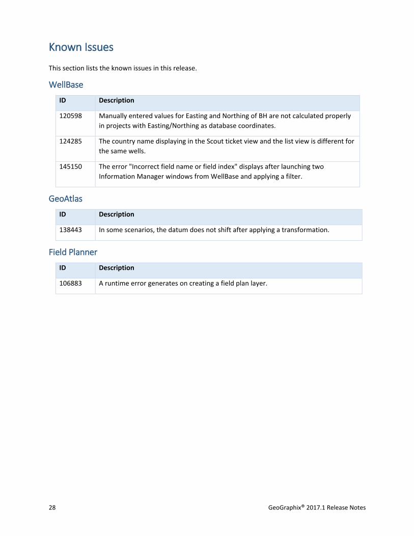
Known Issues ........................................................................................................................................... 28
WellBase ............................................................................................................................................. 28
GeoAtlas .............................................................................................................................................. 28
Field Planner ....................................................................................................................................... 28

ii GeoGraphix® 2017.1 Release Notes
Third Party Applications .......................................................................................................................... 29
International Trademark Compliance ..................................................................................................... 30
Definitions ........................................................................................................................................... 31
Contacting LMKR Support ....................................................................................................................... 32
GeoGraphix® 2017.1 Release Notes 1
GeoGraphix® and Discovery™ on OpenWorks® 2017.1 LMKR is pleased to announce the release of the GeoGraphix® and Discovery™ on OpenWorks® 2017.1
software.
This release includes major Geology upgrades, and also brings many new features and performance
improvements, which are highlighted in the New Features section of this document. The Fixed Issues
section highlights the customer bugs fixed in this release. The Known Issues section lists the unfixed
issues in this release.
This document also provides important information regarding the system requirements and valuable
resources that will allow you to get the most out of the GeoGraphix 2017.1 release.
Note: The GeoGraphix 2017.1 release is a license-control release that requires a license file. The LMKR
License Management Tool (LMT) must be installed to configure the license. Download the latest LMT
from the LMKR Support Portal - Downloads page (http://support.lmkr.com/). See the “LMKR Licensing”
section of the Installation Guide for Release 2017.1 for more information.
Note: If working in a network environment, in order for all computers to work together on shared
projects, ALL computers (clients and servers) must be updated to the same version of the software. It is
intentional that computers with different versions of GeoGraphix software cannot and should not be
connected with each other.
GeoGraphix 2017.1 is an integrated product suite that incorporates shared data management and
geological, petrophysical, and geophysical interpretation software. It utilizes a Sybase (GXDB) database
in GeoGraphix Discovery mode, or accesses the OpenWorks®/SeisWorks® (Oracle) database in Discovery
on OpenWorks mode.
The GeoGraphix software consists of the following:
Pro 3D
Enables interpreters to get the most from their data by quickly creating powerful and informative base maps, fence diagrams and seismic backdrops. Using the Pro 3D window you can show IsoMap® structural surfaces, cultural layers, wells, seismic data, cross sections and fence diagrams in the 3D Scene.
Field Planning
The advanced field planning tool is designed to reduce the time required for efficient field
development. It provides the ability to create, save, analyze and manage multiple field plan
scenarios before committing them to the database. Designed for horizontal well plans, the Field
Planner includes determination of the optimum location and orientation of wells. These proposed
wells can all be visualized by creating a layer for display in GeoAtlas™.
Data Manager™ includes ProjectExplorer™, Coordinate System Manager™, WellBase™, SeisBase™,
QueryBuilder™, LandNet™, LeaseMap™, and ZoneManager™.
The GeoGraphix and Discovery on OpenWorks project and data management engine
2 GeoGraphix® 2017.1 Release Notes
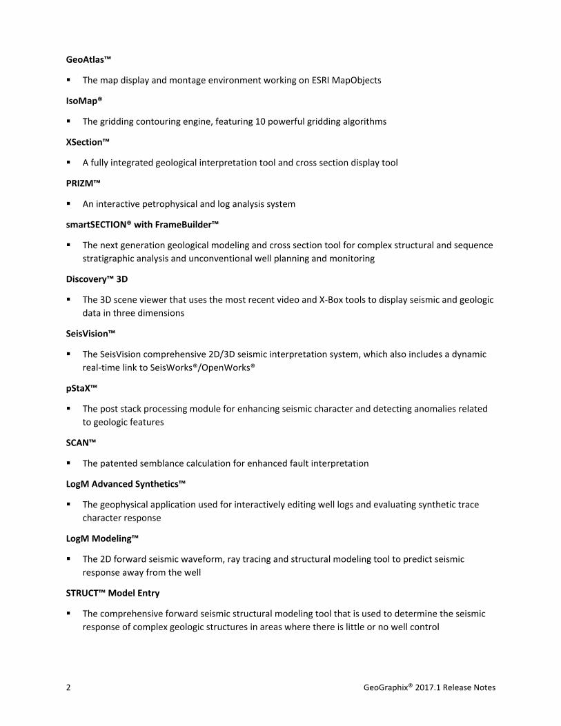
GeoAtlas™
The map display and montage environment working on ESRI MapObjects
IsoMap®
The gridding contouring engine, featuring 10 powerful gridding algorithms
XSection™
A fully integrated geological interpretation tool and cross section display tool
PRIZM™
An interactive petrophysical and log analysis system
smartSECTION® with FrameBuilder™
The next generation geological modeling and cross section tool for complex structural and sequence
stratigraphic analysis and unconventional well planning and monitoring
Discovery™ 3D
The 3D scene viewer that uses the most recent video and X-Box tools to display seismic and geologic
data in three dimensions
SeisVision™
The SeisVision comprehensive 2D/3D seismic interpretation system, which also includes a dynamic
real-time link to SeisWorks®/OpenWorks®
pStaX™
The post stack processing module for enhancing seismic character and detecting anomalies related
to geologic features
SCAN™
The patented semblance calculation for enhanced fault interpretation
LogM Advanced Synthetics™
The geophysical application used for interactively editing well logs and evaluating synthetic trace
character response
LogM Modeling™
The 2D forward seismic waveform, ray tracing and structural modeling tool to predict seismic
response away from the well
STRUCT™ Model Entry
The comprehensive forward seismic structural modeling tool that is used to determine the seismic
response of complex geologic structures in areas where there is little or no well control
GeoGraphix® 2017.1 Release Notes 3
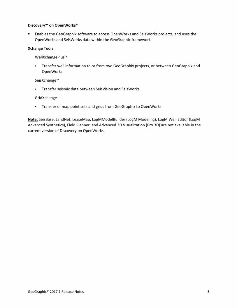
Discovery™ on OpenWorks®
Enables the GeoGraphix software to access OpenWorks and SeisWorks projects, and uses the
OpenWorks and SeisWorks data within the GeoGraphix framework
Xchange Tools
WellXchangePlus™
Transfer well information to or from two GeoGraphix projects, or between GeoGraphix and
OpenWorks
SeisXchange™
Transfer seismic data between SeisVision and SeisWorks
GridXchange
Transfer of map point sets and grids from GeoGraphix to OpenWorks
Note: SeisBase, LandNet, LeaseMap, LogMModelBuilder (LogM Modeling), LogM Well Editor (LogM
Advanced Synthetics), Field Planner, and Advanced 3D Visualization (Pro 3D) are not available in the
current version of Discovery on OpenWorks.
4 GeoGraphix® 2017.1 Release Notes
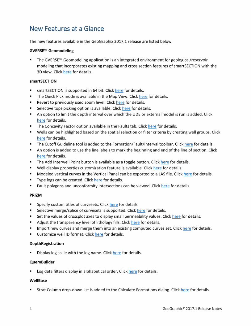
New Features at a Glance
The new features available in the GeoGraphix 2017.1 release are listed below.
GVERSE™ Geomodeling
The GVERSE™ Geomodeling application is an integrated environment for geological/reservoir
modeling that incorporates existing mapping and cross section features of smartSECTION with the
3D view. Click here for details.
smartSECTION
smartSECTION is supported in 64 bit. Click here for details.
The Quick Pick mode is available in the Map View. Click here for details.
Revert to previously used zoom level. Click here for details.
Selective tops picking option is available. Click here for details.
An option to limit the depth interval over which the UDE or external model is run is added. Click
here for details.
The Concavity Factor option available in the Faults tab. Click here for details.
Wells can be highlighted based on the spatial selection or filter criteria by creating well groups. Click
here for details.
The Cutoff Guideline tool is added to the Formation/Fault/Interval toolbar. Click here for details.
An option is added to use the line labels to mark the beginning and end of the line of section. Click
here for details.
The Add Interwell Point button is available as a toggle button. Click here for details.
Well display properties customization feature is available. Click here for details.
Modeled vertical curves in the Vertical Panel can be exported to a LAS file. Click here for details.
Type logs can be created. Click here for details.
Fault polygons and unconformity intersections can be viewed. Click here for details.
PRIZM
Specify custom titles of curvesets. Click here for details.
Selective merge/splice of curvesets is supported. Click here for details.
Set the values of crossplot axes to display small permeability values. Click here for details.
Adjust the transparency level of lithology fills. Click here for details.
Import new curves and merge them into an existing computed curves set. Click here for details.
Customize well ID format. Click here for details.
DepthRegistration
Display log scale with the log name. Click here for details.
QueryBuilder
Log data filters display in alphabetical order. Click here for details.
WellBase
Strat Column drop-down list is added to the Calculate Formations dialog. Click here for details.
GeoGraphix® 2017.1 Release Notes 5
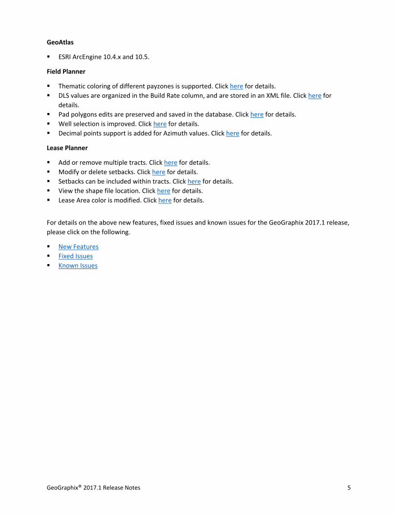
GeoAtlas
ESRI ArcEngine 10.4.x and 10.5.
Field Planner
Thematic coloring of different payzones is supported. Click here for details.
DLS values are organized in the Build Rate column, and are stored in an XML file. Click here for
details.
Pad polygons edits are preserved and saved in the database. Click here for details.
Well selection is improved. Click here for details.
Decimal points support is added for Azimuth values. Click here for details.
Lease Planner
Add or remove multiple tracts. Click here for details.
Modify or delete setbacks. Click here for details.
Setbacks can be included within tracts. Click here for details.
View the shape file location. Click here for details.
Lease Area color is modified. Click here for details.
For details on the above new features, fixed issues and known issues for the GeoGraphix 2017.1 release,
please click on the following.
New Features
Fixed Issues
Known Issues
6 GeoGraphix® 2017.1 Release Notes
System Requirements
In the following sections, you will find hardware and software system requirements for this release of
GeoGraphix and Discovery on OpenWorks:
GeoGraphix Workstation
GeoGraphix Project Server
System requirements can vary considerably, depending on your computing environment and software
objectives. Please contact your Sales Representative or Customer Support if you have questions or need
more information about system requirements.
Important Notes:
The GeoGraphix 2017.1 release is a license-control release that requires a license file. The LMKR
License Management Tool (LMT) must be installed to configure the license. Download the latest
LMT from the LMKR Support Portal - Downloads page (http://support.lmkr.com/). See the “LMKR
Licensing” section of the Installation Guide for Release 2017.1 for more information.
Discovery on OpenWorks is compatible with OpenWorks for Windows 5000.10.3.02 and SeisWorks
5000.10.
Please also refer to the GeoGraphix Customer Support Portal (http://support.lmkr.com) for up-to-
date information on system requirements for all GeoGraphix products.
GeoGraphix Workstation and Laptops
The requirements for GeoGraphix Workstation and Laptops are as follows:
Software and Hardware Requirements
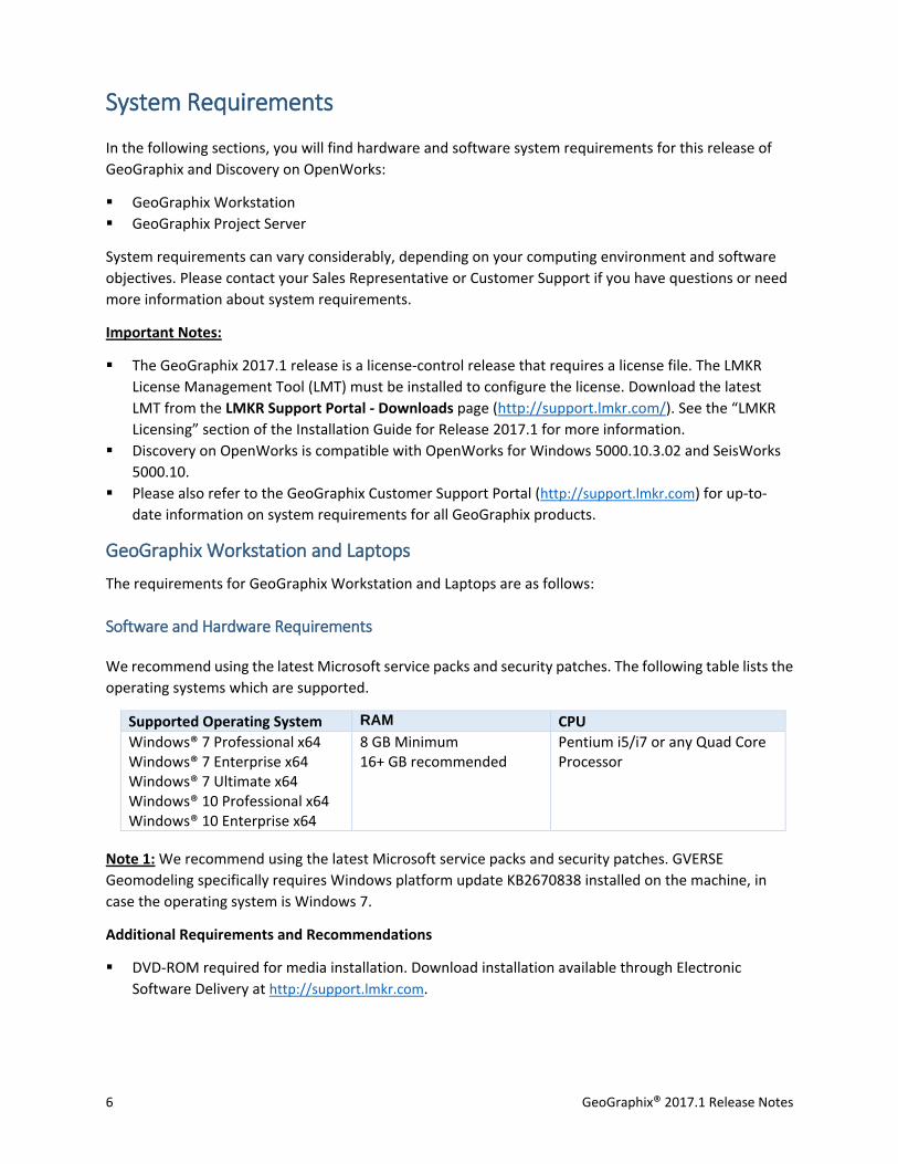
We recommend using the latest Microsoft service packs and security patches. The following table lists the
operating systems which are supported.
Supported Operating System RAM CPU
Windows® 7 Professional x64 Windows® 7 Enterprise x64 Windows® 7 Ultimate x64 Windows® 10 Professional x64 Windows® 10 Enterprise x64
8 GB Minimum 16+ GB recommended
Pentium i5/i7 or any Quad Core Processor
Note 1: We recommend using the latest Microsoft service packs and security patches. GVERSE
Geomodeling specifically requires Windows platform update KB2670838 installed on the machine, in
case the operating system is Windows 7.
Additional Requirements and Recommendations
DVD-ROM required for media installation. Download installation available through Electronic
Software Delivery at http://support.lmkr.com.
GeoGraphix® 2017.1 Release Notes 7
DCOM/Firewalls configuration is required to allow remote access. This is necessary when working
with shared projects on the network.
Microsoft .NET 4.5.1 runtime required.
Graphics Hardware Requirements
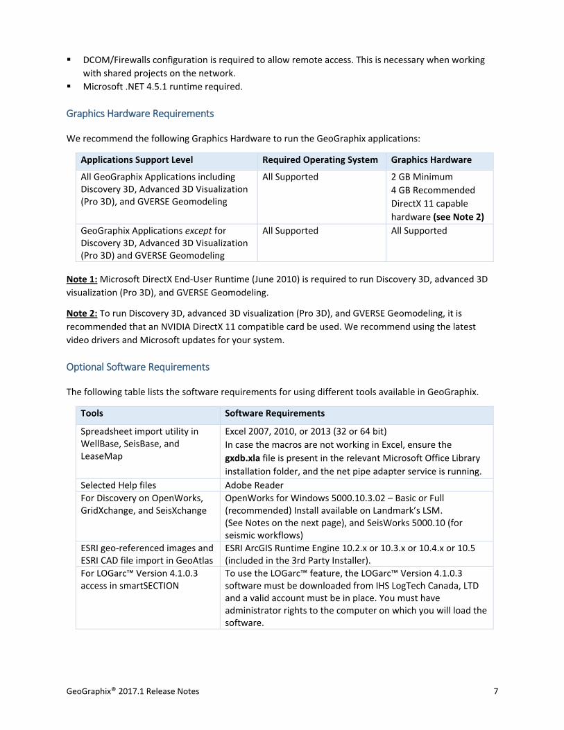
We recommend the following Graphics Hardware to run the GeoGraphix applications:
Applications Support Level Required Operating System Graphics Hardware
All GeoGraphix Applications including Discovery 3D, Advanced 3D Visualization (Pro 3D), and GVERSE Geomodeling
All Supported 2 GB Minimum
4 GB Recommended
DirectX 11 capable
hardware (see Note 2)
GeoGraphix Applications except for Discovery 3D, Advanced 3D Visualization (Pro 3D) and GVERSE Geomodeling
All Supported All Supported
Note 1: Microsoft DirectX End-User Runtime (June 2010) is required to run Discovery 3D, advanced 3D
visualization (Pro 3D), and GVERSE Geomodeling.
Note 2: To run Discovery 3D, advanced 3D visualization (Pro 3D), and GVERSE Geomodeling, it is
recommended that an NVIDIA DirectX 11 compatible card be used. We recommend using the latest
video drivers and Microsoft updates for your system.
Optional Software Requirements
The following table lists the software requirements for using different tools available in GeoGraphix.
Tools Software Requirements
Spreadsheet import utility in WellBase, SeisBase, and LeaseMap
Excel 2007, 2010, or 2013 (32 or 64 bit)
In case the macros are not working in Excel, ensure the
gxdb.xla file is present in the relevant Microsoft Office Library
installation folder, and the net pipe adapter service is running.
Selected Help files Adobe Reader
For Discovery on OpenWorks, GridXchange, and SeisXchange
OpenWorks for Windows 5000.10.3.02 – Basic or Full (recommended) Install available on Landmark’s LSM. (See Notes on the next page), and SeisWorks 5000.10 (for seismic workflows)
ESRI geo-referenced images and ESRI CAD file import in GeoAtlas
ESRI ArcGIS Runtime Engine 10.2.x or 10.3.x or 10.4.x or 10.5 (included in the 3rd Party Installer).
For LOGarc™ Version 4.1.0.3 access in smartSECTION
To use the LOGarc™ feature, the LOGarc™ Version 4.1.0.3 software must be downloaded from IHS LogTech Canada, LTD and a valid account must be in place. You must have administrator rights to the computer on which you will load the software.
8 GeoGraphix® 2017.1 Release Notes
Notes for Discovery on OpenWorks: The OpenWorks Full installation requires Hummingbird Exceed.
The Oracle client installation in use with the OpenWorks Full installation requires that the
“Administrator” option be selected. The “Administrator” option type includes the SQL Plus and the
Oracle Database Utilities components, which are needed to run Discovery on OpenWorks, as part of the
total OpenWorks package.
Note: Hummingbird Exceed is not required for the OpenWorks Basic installation. If the OpenWorks Basic
installation is used, the Oracle client installation can use the “Administrator” option, which will include
all of the needed components. Or, the Oracle client installation for the OpenWorks Basic installation can
use the “Custom” installation type. However, the following components must be installed with the
“Custom” installation type:
Oracle Database Utilities
SQL*Plus
Oracle JDBC/THIN Interfaces
Oracle Net
GeoGraphix Project Server
The requirements for GeoGraphix Project Server are as follows:
Software and Hardware Requirements
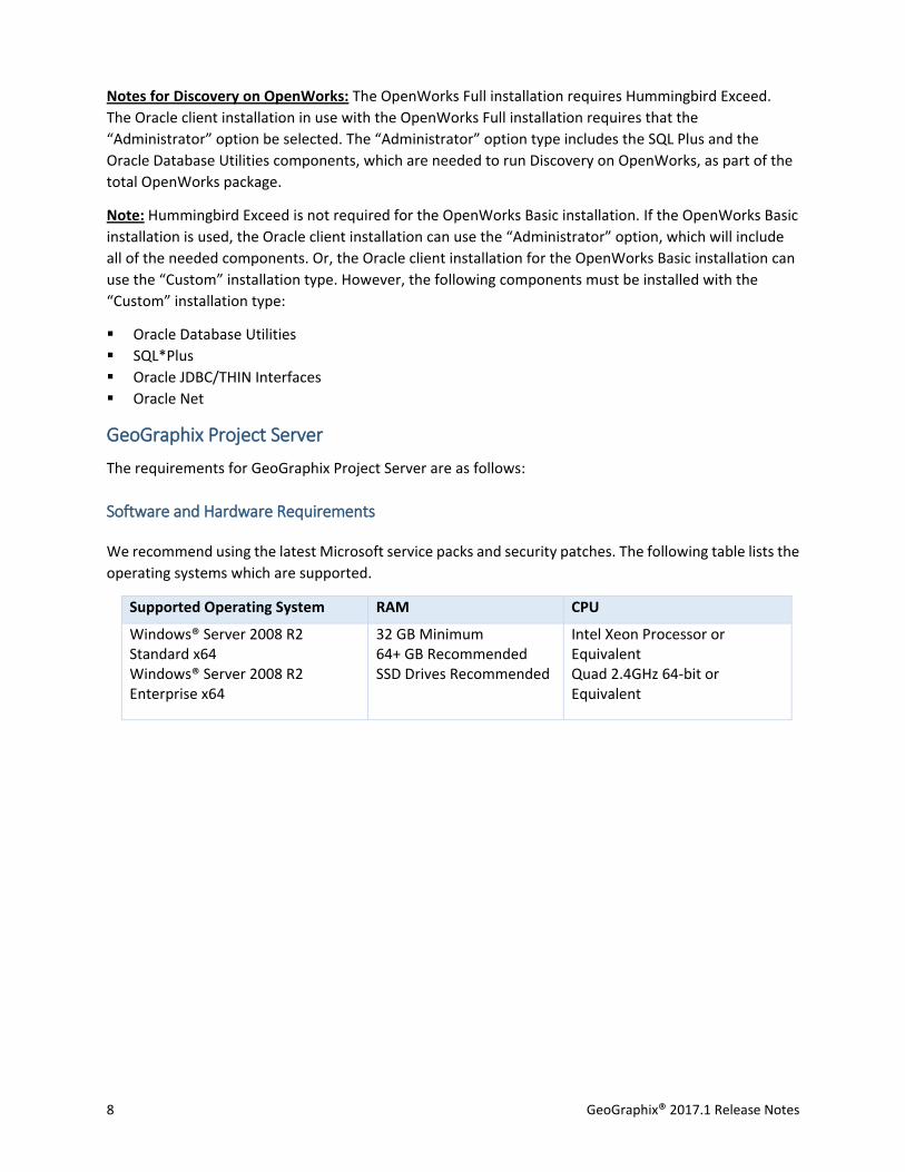
We recommend using the latest Microsoft service packs and security patches. The following table lists the
operating systems which are supported.
Supported Operating System RAM CPU
Windows® Server 2008 R2 Standard x64 Windows® Server 2008 R2 Enterprise x64
32 GB Minimum 64+ GB Recommended SSD Drives Recommended
Intel Xeon Processor or Equivalent Quad 2.4GHz 64-bit or Equivalent
GeoGraphix® 2017.1 Release Notes 9
Additional Requirements and Recommendations
DVD-ROM is required for media installation.
DCOM/Firewalls configuration is required to allow remote access. This is necessary when working
with shared projects on the network. For DCOM configuration recommendations, refer to the white
papers on the LMKR Support Portal.
Server performance is subject to a large number of variables. It is impossible to give specific
recommendations here, but these are some guiding principles to use. In general, multi-user performance
of a GeoGraphix project server is best when the server is dedicated to GeoGraphix and not shared with
other applications, especially database applications or intensive file-system applications. In addition,
consideration should be made for the number of GeoGraphix users and the size and number of
concurrently accessed projects. At some point, having multiple project servers becomes a better solution
than having all users on one server. Generally, somewhere between 10 and 20 users is when a second
server might be suggested.
Networking
Networking performance depends on the number of users trying to access a server simultaneously, as
well as the bandwidth requirements for those users. Recommendations for server bandwidth typically
specify server connectivity at a higher bandwidth than an individual user. For instance, users running at
100 Mbit should be accessing a server running on a 1-Gbit backbone. If users are at 1 Gbit, consider
running multiple 1-Gbit connections or a single higher-bandwidth connection on the server.
Database Cache
A large database cache is an important factor to consider when dealing with multiple users accessing large
databases. The database engine is capable of addressing a practically unlimited amount of cache memory.
The best way to size the memory is to estimate the memory requirements for other running applications
and allow the database cache to dynamically allocate any remaining free memory. The engine will only
allocate what it needs when using dynamic allocation up to the maximum specified.
It is highly recommended that you let the database engine use as much cache memory as it requires on
the host server. Increasing database cache memory is the quickest and most effective way to improve
database- related performance on large network projects.
On a workstation, it might be appropriate to reserve 1 to 2 GB for the OS and file system cache and 2 to 4
GB for other running applications. On a dedicated project server, not much memory needs to be reserved
for other applications. The ideal maximum varies by the project size, the number of users, and other load
considerations. But as a general rule, the higher you can set the maximum, the better.
Storage
A great deal of GeoGraphix’s access patterns on a server deal with file I/O. Database access, raster images,
and seismic data are examples of files that benefit substantially from a fast disk sub-system. Server
environments also place a high importance on data integrity and reliability. At a minimum, consider using
a RAID 5 (stripe-set with parity) array. As the size of disks increase, you may also want to consider a hot
10 GeoGraphix® 2017.1 Release Notes
swap drive and/or RAID 6 (striped with dual parity). Using a controller card with its own cache can also
help improve performance.
Network Attached Storage (NAS), Storage Area Networks (SAN), and Other Non-Windows Storage
Solutions
There are two typical methods used for accessing external storage devices from a project server: iSCSI and
CIFS.
iSCSI allocates a block of storage on the external device and makes it appear to be a physical disk on
the project server. This has the advantage of a 100% compliant file system. However, since the
external device sees the allocation as one big file, it can make backing up and restoring of individual
files using the external device's capabilities more difficult. Standard backup and restore procedures
from the server will still work.
Using CIFS for external storage devices depends greatly on the vendor’s implementation of the CIFS
protocol used by the Windows platform. In general, a 100% compliant implementation of CIFS for a
performant system is required. In particular, vendor's implementation of the "File Change/Notify"
functionality has been problematic. Devices based on Windows Storage Server should be 100%
compatible since it shares its components with Windows. Implementations based on UNIX/Linux are
where problems occur due to the fact that the kernel level support is not present. Due to these
uncertainties with CIFS implementations LMKR does not technically support CIFS.
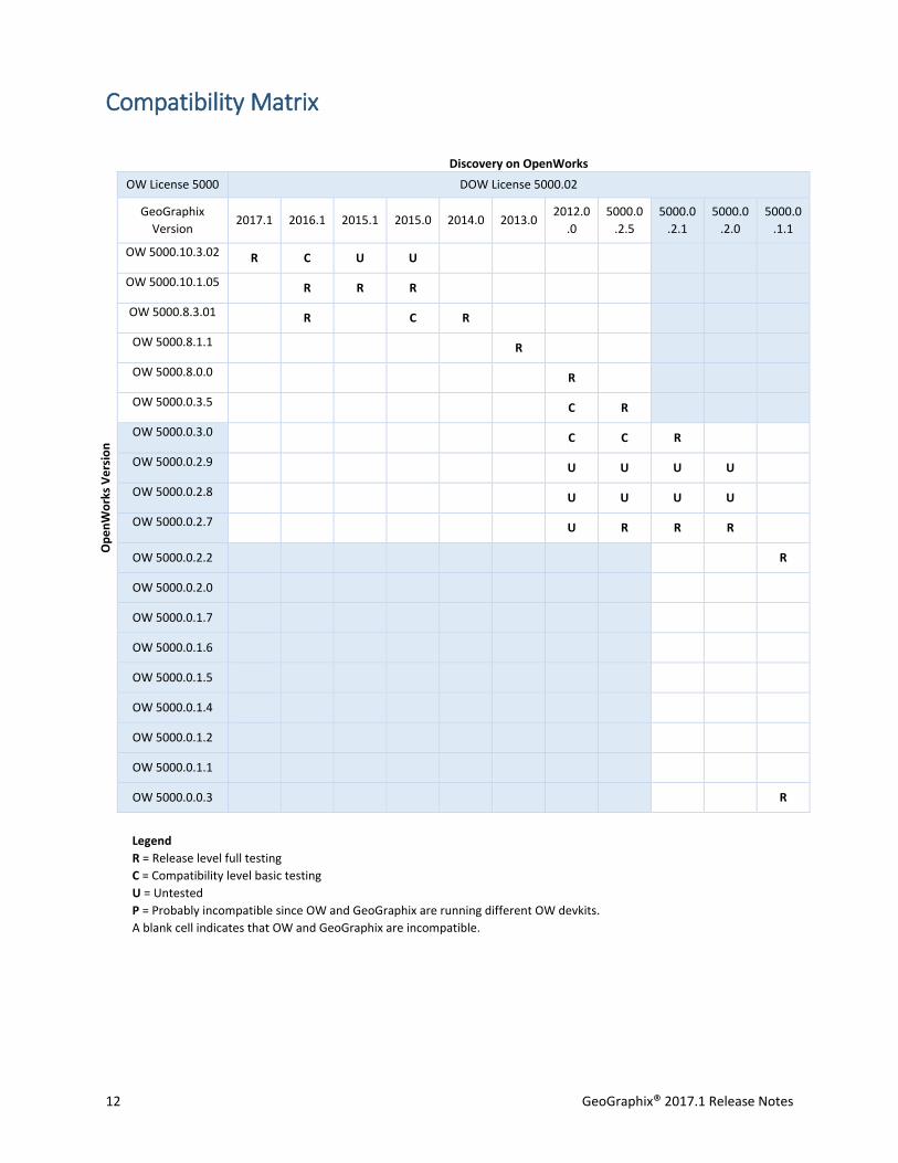
Compatibility with OpenWorks Software
The Discovery™ on OpenWorks® (DOW) software directly links a GeoGraphix application to the data in an
OpenWorks® project, and provides a shared project environment for interpretation applications.
Landmark Software has delivered the OpenWorks and DOW software for Release 5000 and will continue
to provide updates and enhancements to these products. When planning your uptake of Release 5000
and verifying your workflow, you should consider version compatibility between the OpenWorks software
and the Discovery on OpenWorks software.
In the compatibility table below, the table indicates the level of compatibility of previous releases and of
upcoming scheduled and planned releases. This table will be updated as new releases are planned. The
objective is to provide closely coupled compatible versions of the software to allow you to more easily
take up current releases.
LMKR performs full release testing for those combinations indicated as Release, R, in the table, but may
not exercise full release testing on other version combinations. For these iterative releases, LMKR
performs compatibility testing between the OpenWorks and DOW software (indicated as Compatibility,
C, in the table). See the table below for the level of testing for each version combination. Although LMKR
does not anticipate any integration issue, in these cases it is recommended that customers also verify
compatibility in their own environment.
LMKR supports the versions listed as Release in the table. However, while LMKR has completed
compatibility testing, LMKR/GeoGraphix Support may not be able to fully support the versions listed as
Compatibility in the table. When customers request support for a Compatibility environment,
GeoGraphix® 2017.1 Release Notes 11
LMKR/GeoGraphix Support works on a best effort basis to troubleshoot any issues, and if an issue needs
additional attention, LMKR/GeoGraphix Support reports such issues to LMKR Research & Development.
The LMKR/GeoGraphix Support Team cannot guarantee any resolution service levels associated with
issues from a compatibility environment.
Combinations which have not been tested, either in the full release or in a compatibility environment, are
indicated by U (untested). P indicates the indicated versions are probably incompatible, as the OpenWorks
version has a newer development kit (devkit) than that of the indicated DOW version. Blank cells in the
table indicate that OpenWorks and GeoGraphix are incompatible and will not operate together.
For the most current version of this information and an overview of suggested compatibility test paths,
please refer to the LMKR Technical Support Solution Document KBA-65218-F9D7D5.
12 GeoGraphix® 2017.1 Release Notes
Compatibility Matrix
Discovery on OpenWorks
OW License 5000 DOW License 5000.02
GeoGraphix
Version 2017.1 2016.1 2015.1 2015.0 2014.0 2013.0
2012.0
.0
5000.0
.2.5
5000.0
.2.1
5000.0
.2.0
5000.0
.1.1
Op
en
Wo
rks
Ve
rsio
n
OW 5000.10.3.02 R C U U
OW 5000.10.1.05 R R R
OW 5000.8.3.01 R C R
OW 5000.8.1.1 R
OW 5000.8.0.0 R
OW 5000.0.3.5 C R
OW 5000.0.3.0 C C R
OW 5000.0.2.9 U U U U
OW 5000.0.2.8 U U U U
OW 5000.0.2.7 U R R R
OW 5000.0.2.2 R
OW 5000.0.2.0
OW 5000.0.1.7
OW 5000.0.1.6
OW 5000.0.1.5
OW 5000.0.1.4
OW 5000.0.1.2
OW 5000.0.1.1
OW 5000.0.0.3 R
Legend
R = Release level full testing
C = Compatibility level basic testing
U = Untested
P = Probably incompatible since OW and GeoGraphix are running different OW devkits.
A blank cell indicates that OW and GeoGraphix are incompatible.
GeoGraphix® 2017.1 Release Notes 13
New Features
This section contains a brief description of the exciting new features included in the 2017.1 release.
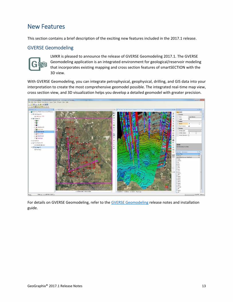
GVERSE Geomodeling
LMKR is pleased to announce the release of GVERSE Geomodeling 2017.1. The GVERSE
Geomodeling application is an integrated environment for geological/reservoir modeling
that incorporates existing mapping and cross section features of smartSECTION with the
3D view.
With GVERSE Geomodeling, you can integrate petrophysical, geophysical, drilling, and GIS data into your
interpretation to create the most comprehensive geomodel possible. The integrated real-time map view,
cross section view, and 3D visualization helps you develop a detailed geomodel with greater precision.
For details on GVERSE Geomodeling, refer to the GVERSE Geomodeling release notes and installation
guide.
14 GeoGraphix® 2017.1 Release Notes
smartSECTION
This section introduces the updates made in smartSECTION.
smartSECTION 64 bit smartSECTION is supported in 64 bit to enable users to work seamlessly with larger projects.
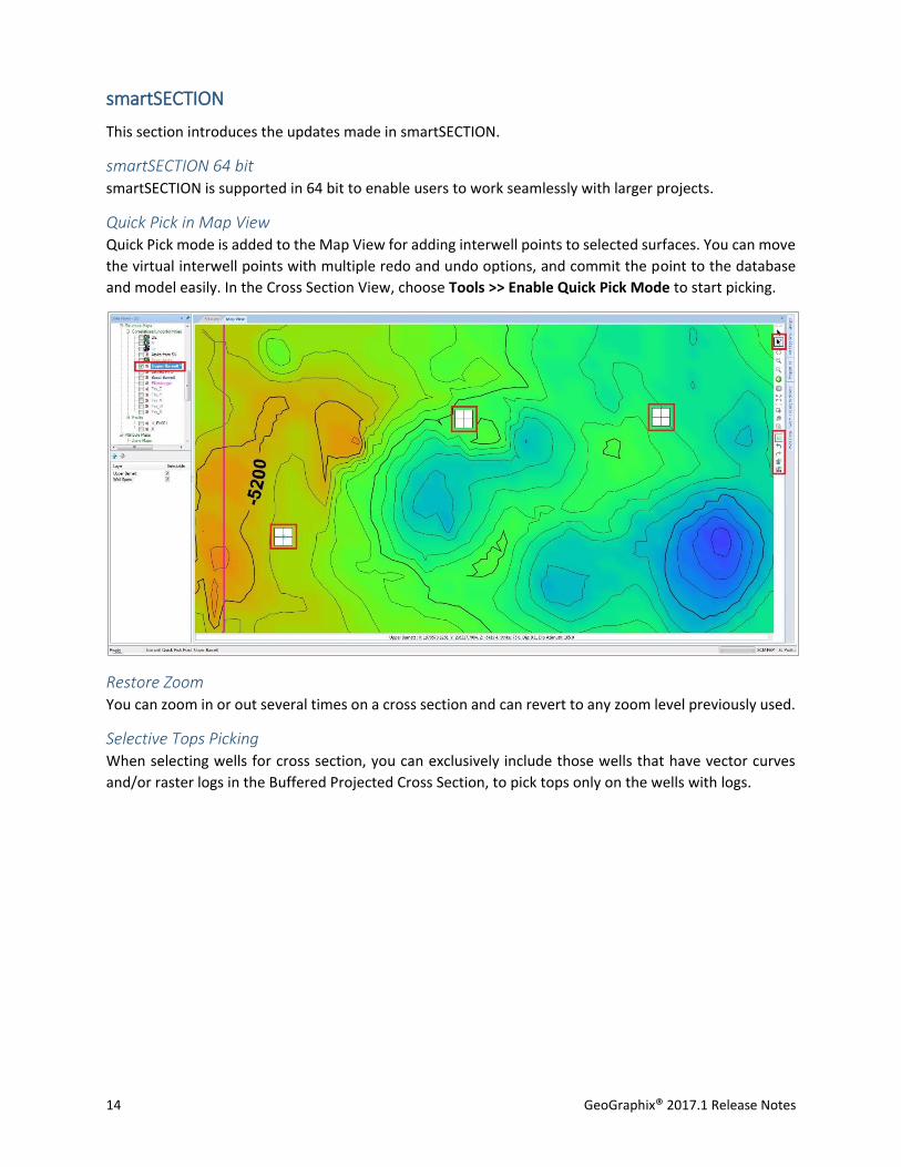
Quick Pick in Map View Quick Pick mode is added to the Map View for adding interwell points to selected surfaces. You can move
the virtual interwell points with multiple redo and undo options, and commit the point to the database
and model easily. In the Cross Section View, choose Tools >> Enable Quick Pick Mode to start picking.
Restore Zoom You can zoom in or out several times on a cross section and can revert to any zoom level previously used.
Selective Tops Picking When selecting wells for cross section, you can exclusively include those wells that have vector curves
and/or raster logs in the Buffered Projected Cross Section, to pick tops only on the wells with logs.
GeoGraphix® 2017.1 Release Notes 15
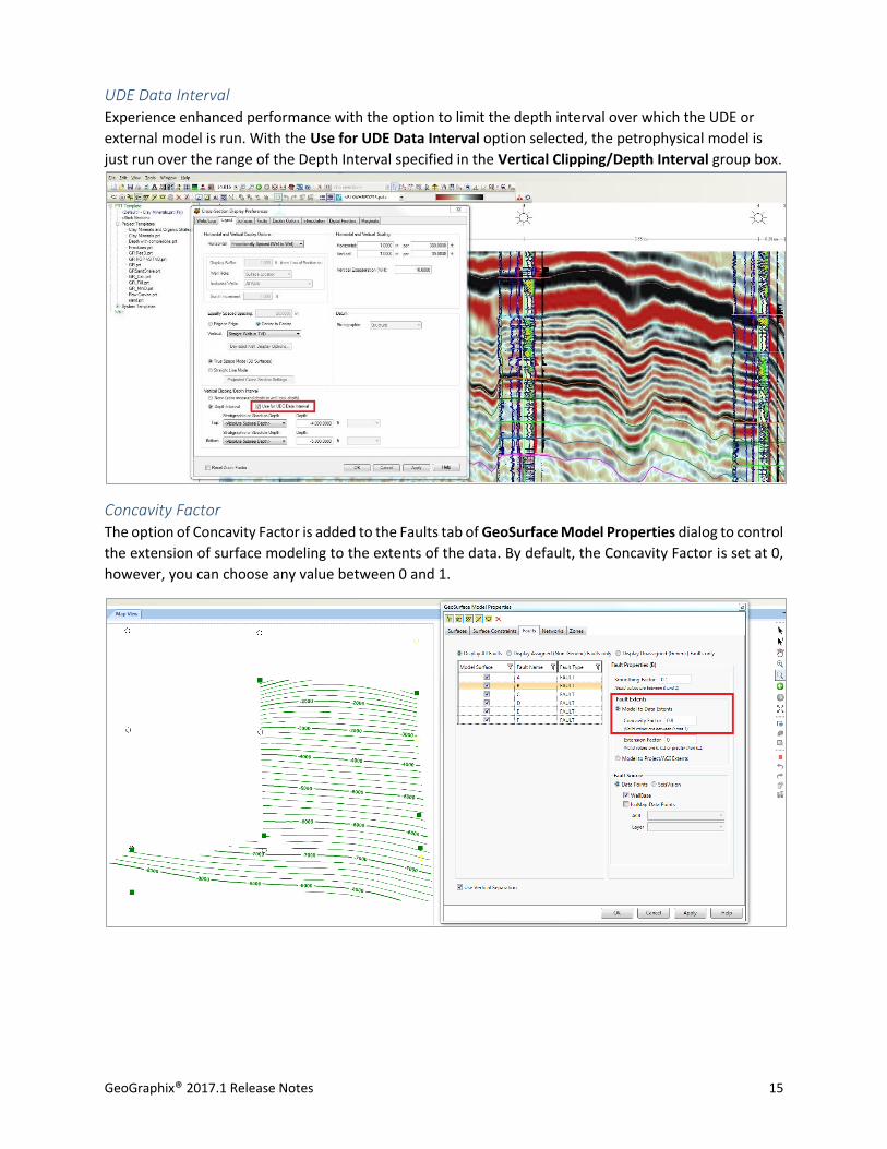
UDE Data Interval Experience enhanced performance with the option to limit the depth interval over which the UDE or
external model is run. With the Use for UDE Data Interval option selected, the petrophysical model is
just run over the range of the Depth Interval specified in the Vertical Clipping/Depth Interval group box.
Concavity Factor The option of Concavity Factor is added to the Faults tab of GeoSurface Model Properties dialog to control
the extension of surface modeling to the extents of the data. By default, the Concavity Factor is set at 0,
however, you can choose any value between 0 and 1.
16 GeoGraphix® 2017.1 Release Notes
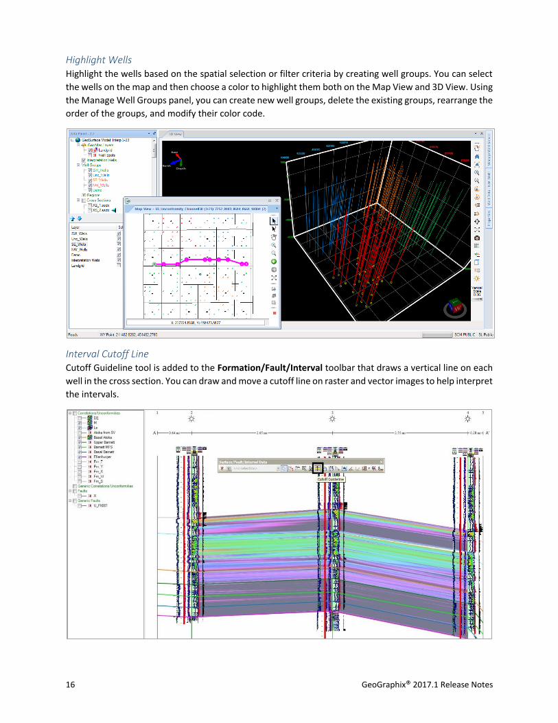
Highlight Wells Highlight the wells based on the spatial selection or filter criteria by creating well groups. You can select
the wells on the map and then choose a color to highlight them both on the Map View and 3D View. Using
the Manage Well Groups panel, you can create new well groups, delete the existing groups, rearrange the
order of the groups, and modify their color code.
Interval Cutoff Line Cutoff Guideline tool is added to the Formation/Fault/Interval toolbar that draws a vertical line on each
well in the cross section. You can draw and move a cutoff line on raster and vector images to help interpret
the intervals.
GeoGraphix® 2017.1 Release Notes 17
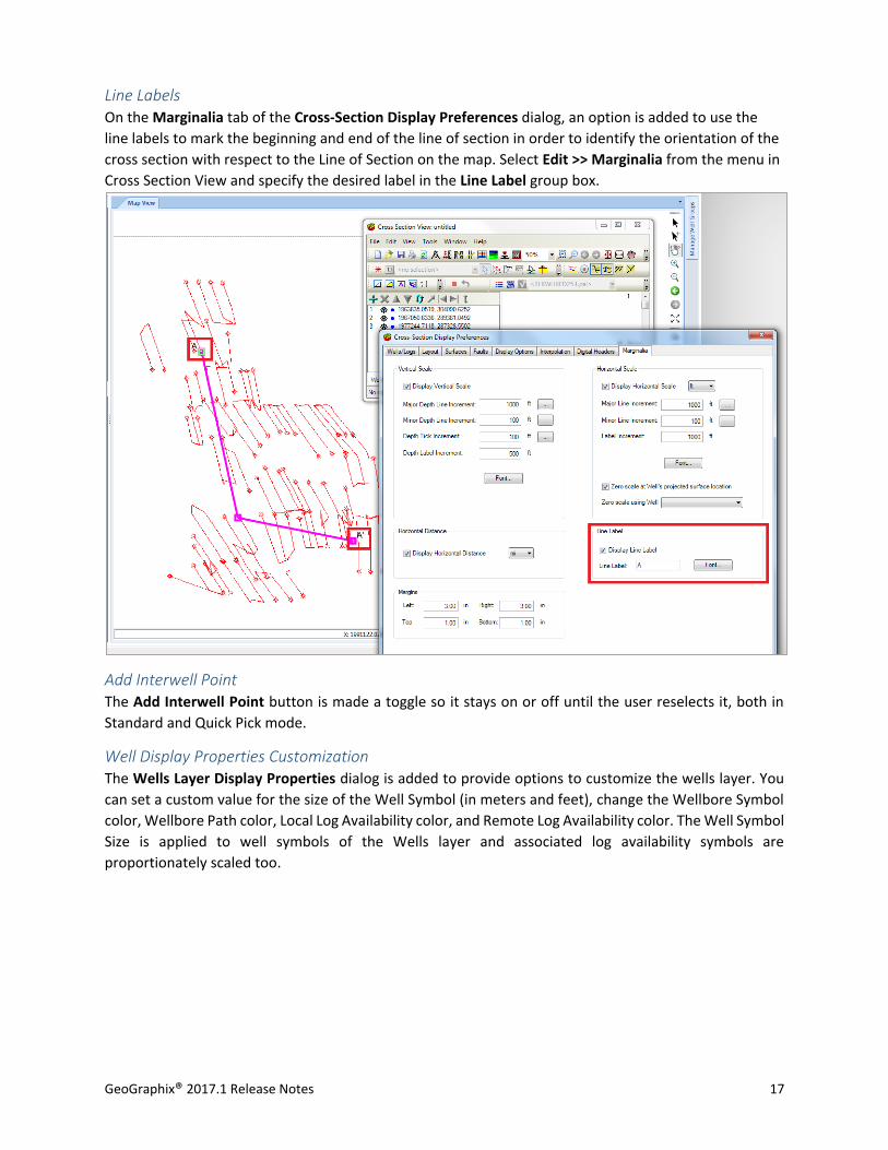
Line Labels On the Marginalia tab of the Cross-Section Display Preferences dialog, an option is added to use the
line labels to mark the beginning and end of the line of section in order to identify the orientation of the
cross section with respect to the Line of Section on the map. Select Edit >> Marginalia from the menu in
Cross Section View and specify the desired label in the Line Label group box.
Add Interwell Point The Add Interwell Point button is made a toggle so it stays on or off until the user reselects it, both in
Standard and Quick Pick mode.
Well Display Properties Customization The Wells Layer Display Properties dialog is added to provide options to customize the wells layer. You
can set a custom value for the size of the Well Symbol (in meters and feet), change the Wellbore Symbol
color, Wellbore Path color, Local Log Availability color, and Remote Log Availability color. The Well Symbol
Size is applied to well symbols of the Wells layer and associated log availability symbols are
proportionately scaled too.

18 GeoGraphix® 2017.1 Release Notes
Vertical Curve Export to LAS Export the modeled vertical curves in the Vertical Panel to a LAS file to use the curve in other applications.
The smartSTRAT Options dialog provides options to export all curves or only the first encountered curves
with their depths in MD or TVD. To use this option, select Tools >> smartSTRAT Tool from the cross section
view menu bar, and then click Options button >> Vertical Panel tab.
Type Log Create a Type Log to quickly and effectively correlate or pick formation tops in a cross section. Choose
Tools >> Type Log >> New to create a new type log. You can save, flip, resize, or hide the type log or drag
the formation tops to the desired position required for correlation.
GeoGraphix® 2017.1 Release Notes 19
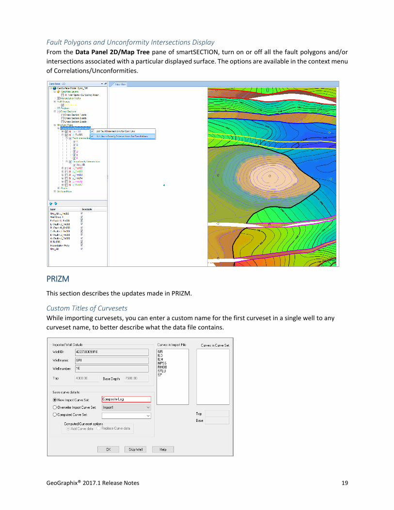
Fault Polygons and Unconformity Intersections Display From the Data Panel 2D/Map Tree pane of smartSECTION, turn on or off all the fault polygons and/or
intersections associated with a particular displayed surface. The options are available in the context menu
of Correlations/Unconformities.
PRIZM
This section describes the updates made in PRIZM.
Custom Titles of Curvesets While importing curvesets, you can enter a custom name for the first curveset in a single well to any
curveset name, to better describe what the data file contains.
20 GeoGraphix® 2017.1 Release Notes
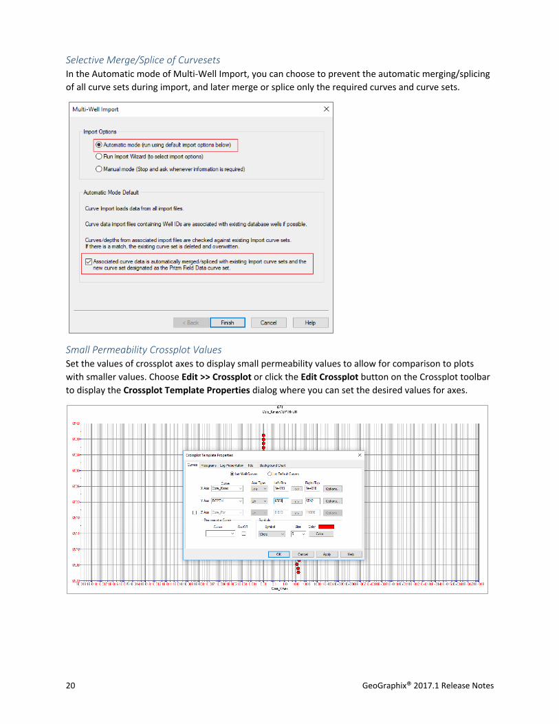
Selective Merge/Splice of Curvesets In the Automatic mode of Multi-Well Import, you can choose to prevent the automatic merging/splicing
of all curve sets during import, and later merge or splice only the required curves and curve sets.
Small Permeability Crossplot Values Set the values of crossplot axes to display small permeability values to allow for comparison to plots
with smaller values. Choose Edit >> Crossplot or click the Edit Crossplot button on the Crossplot toolbar
to display the Crossplot Template Properties dialog where you can set the desired values for axes.

GeoGraphix® 2017.1 Release Notes 21
Lithology Fill Transparency Adjust the transparency level of the lithology fill to view what is behind the fills on the presentation log.
Choose Edit >> Area Fills, or click the Edit Areas button on the Log toolbar, to access the Log
Template Properties dialog where you can specify the area fill transparency settings.
Import and Merge Curves Import new curves and merge them into an existing computed curves set instead of replacing them, and
use the new curves in petrophysical analysis. From the Existing Curve Data for File dialog, choose the
Add Curve data option to add and merge the curve set data with the existing computed curve set data.
Customization of Well ID Format While importing curves, you can choose to strip-out the dashes (-) in a Well ID in order to get the API in
an LAS file that contains dashes to match the wells in WellBase without dashes.
22 GeoGraphix® 2017.1 Release Notes
DepthRegistration
This section describes the updates made in DepthRegistration.
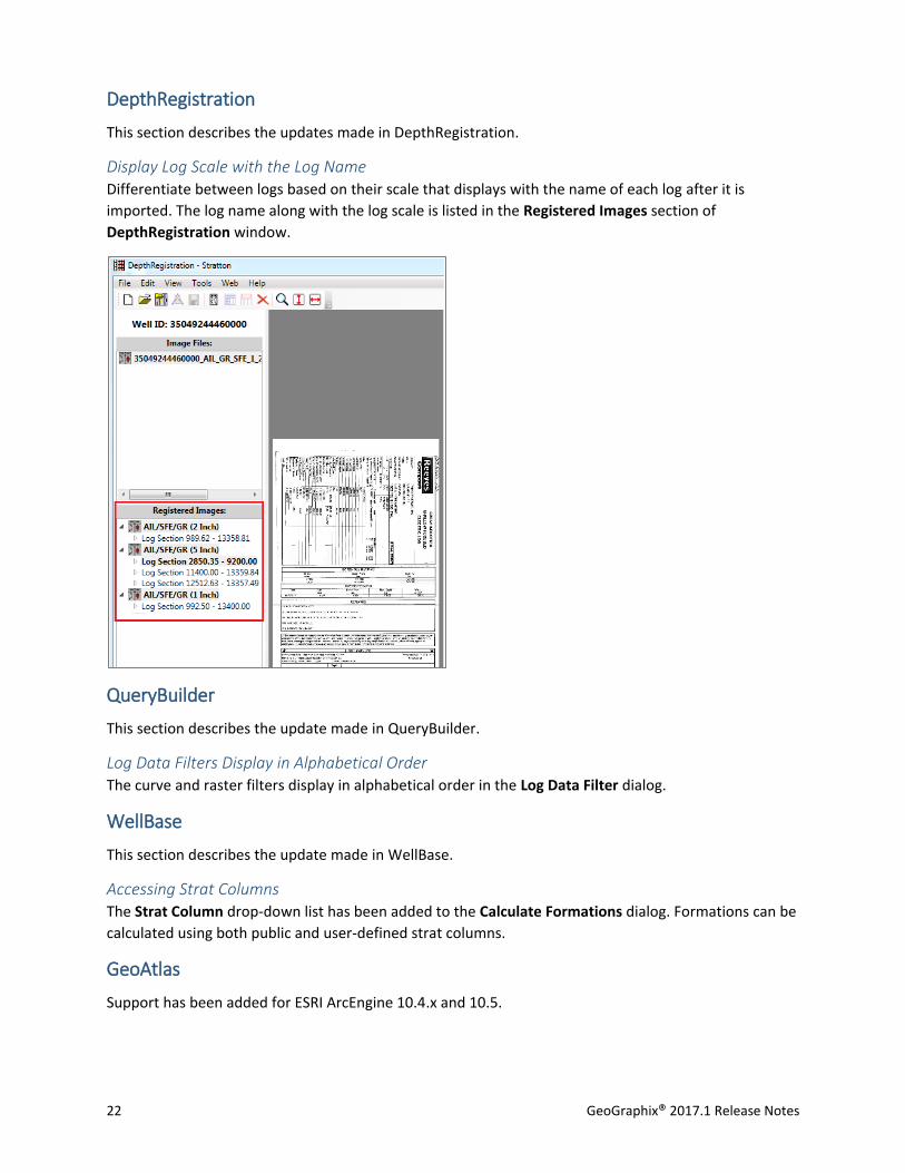
Display Log Scale with the Log Name Differentiate between logs based on their scale that displays with the name of each log after it is
imported. The log name along with the log scale is listed in the Registered Images section of
DepthRegistration window.
QueryBuilder
This section describes the update made in QueryBuilder.
Log Data Filters Display in Alphabetical Order The curve and raster filters display in alphabetical order in the Log Data Filter dialog.
WellBase
This section describes the update made in WellBase.
Accessing Strat Columns The Strat Column drop-down list has been added to the Calculate Formations dialog. Formations can be
calculated using both public and user-defined strat columns.
GeoAtlas
Support has been added for ESRI ArcEngine 10.4.x and 10.5.
GeoGraphix® 2017.1 Release Notes 23
Field Planner
This section describes the updates made in Field Planner.
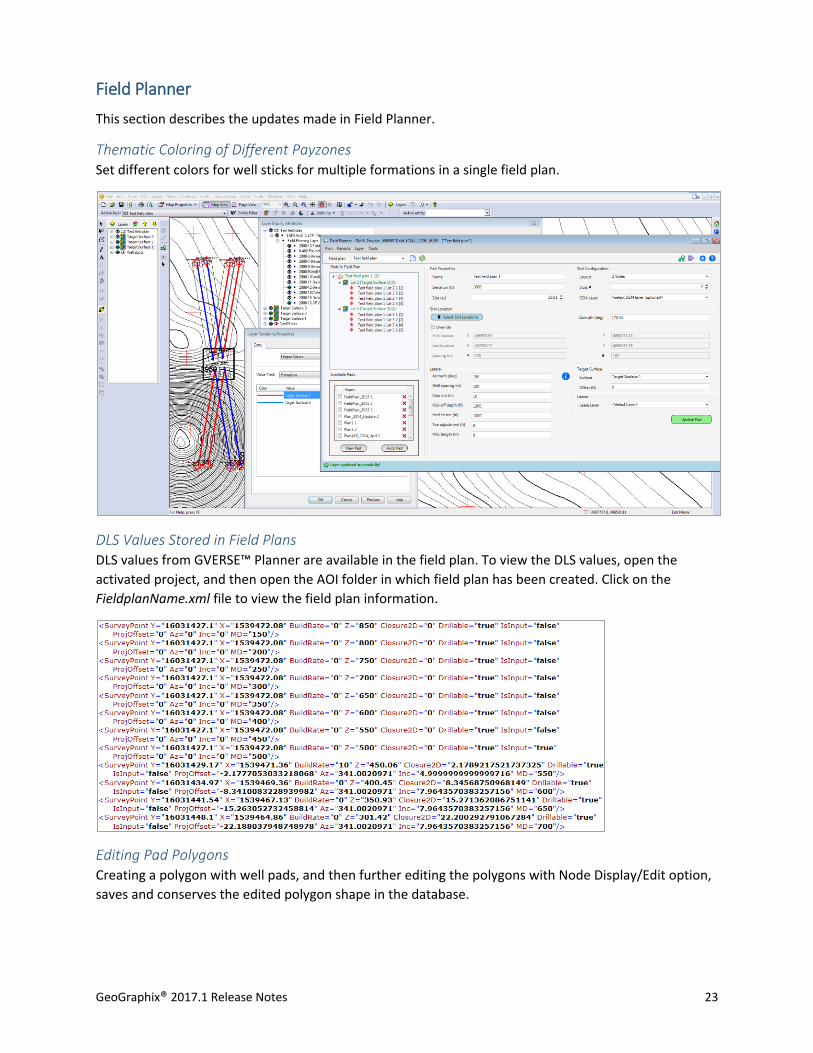
Thematic Coloring of Different Payzones Set different colors for well sticks for multiple formations in a single field plan.
DLS Values Stored in Field Plans DLS values from GVERSE™ Planner are available in the field plan. To view the DLS values, open the
activated project, and then open the AOI folder in which field plan has been created. Click on the
FieldplanName.xml file to view the field plan information.
Editing Pad Polygons Creating a polygon with well pads, and then further editing the polygons with Node Display/Edit option,
saves and conserves the edited polygon shape in the database.
24 GeoGraphix® 2017.1 Release Notes
Well Selection Improved Select wells by simply clicking on them. Previously, wells could only be selected using the context menu.
Decimal Points for Azimuth Values Azimuth values can be specified up two decimal places.
Lease Planner
This section describes the updates made in Lease Planner.
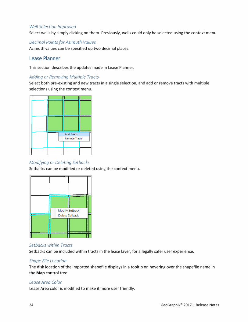
Adding or Removing Multiple Tracts Select both pre-existing and new tracts in a single selection, and add or remove tracts with multiple
selections using the context menu.
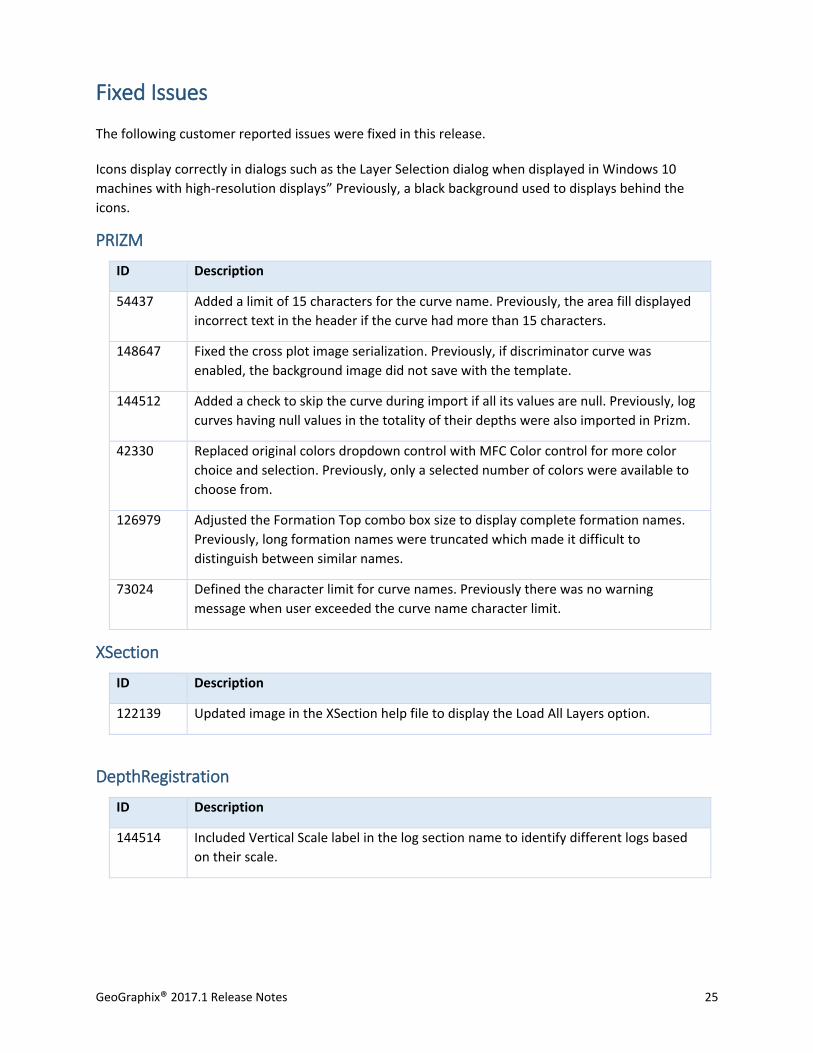
Modifying or Deleting Setbacks Setbacks can be modified or deleted using the context menu.
Setbacks within Tracts Setbacks can be included within tracts in the lease layer, for a legally safer user experience.
Shape File Location The disk location of the imported shapefile displays in a tooltip on hovering over the shapefile name in
the Map control tree.
Lease Area Color Lease Area color is modified to make it more user friendly.
GeoGraphix® 2017.1 Release Notes 25
Fixed Issues
The following customer reported issues were fixed in this release.
Icons display correctly in dialogs such as the Layer Selection dialog when displayed in Windows 10
machines with high-resolution displays” Previously, a black background used to displays behind the
icons.
PRIZM
ID Description
54437 Added a limit of 15 characters for the curve name. Previously, the area fill displayed
incorrect text in the header if the curve had more than 15 characters.
148647 Fixed the cross plot image serialization. Previously, if discriminator curve was
enabled, the background image did not save with the template.
144512 Added a check to skip the curve during import if all its values are null. Previously, log
curves having null values in the totality of their depths were also imported in Prizm.
42330 Replaced original colors dropdown control with MFC Color control for more color
choice and selection. Previously, only a selected number of colors were available to
choose from.
126979 Adjusted the Formation Top combo box size to display complete formation names.
Previously, long formation names were truncated which made it difficult to
distinguish between similar names.
73024 Defined the character limit for curve names. Previously there was no warning
message when user exceeded the curve name character limit.
XSection
ID Description
122139 Updated image in the XSection help file to display the Load All Layers option.
DepthRegistration
ID Description
144514 Included Vertical Scale label in the log section name to identify different logs based
on their scale.
26 GeoGraphix® 2017.1 Release Notes
smartSECTION
ID Description
12539 Type Log functionality that was previously available in XSection is now implemented
in smartSECTION.
141275 Object is properly disposed and velocity model related files no longer pile up on the
disk. Previously, TMP files were created on opening cross sections but were not
deleted on closing them.
27713 Added the ability to limit the data interval over which UDE or PEM is run. Previously,
the depth interval over which a UDE or PEM was executed was not honored and the
results were incorrect.
129869 Improved deviated templates rendering code to prevent overlapping of regions in
deviated wells due to the stretching and squeezing of template bitmaps.
144496 Shipped correct version of Xceed DLLS with installer. TGS connectivity for data
downloads was not working for 2016.1 release.
129868 Improved PRT Templates rendering code. Previously, noise was observed for
templates having lithology fills in deviated wells cross sections.
SeisVision
ID Description
147910 Re-adding wells and formations in an interpretation with hidden wells no longer
results in application crash on save.
147913 Re-adding all wells and formations after saving an interpretation no longer results in
application crash on saving the interpretation again.
GeoAtlas
ID Description
125821 Volume calculations for boundary and clipping polygons are calculated correctly.
QueryBuilder
ID Description
2345 The results in the query builder are sorted in descending order.
GeoGraphix® 2017.1 Release Notes 27
WellBase
ID Description
145235 The performance of WellBase and ZoneManager is improved for projects with
protected well data.
142035 The borehole latitude and longitude values are saved correctly after applying a
transformation.
133511 The formation calculation performance is significantly improved.
132767 The transform coordinate feature works correctly for projects with Easting &
Northing as database coordinates.
129628 Quick filters take less time while activated in WellBase.
127083 The data export using an ASCII 4 file is faster.
126824 Locating a well using the Find tool is much faster.
122889 Performance scrolling through WellBase is improved.
119634 The data for county fields for Texas displays accurately after importing IHS 297 into a
new project.
Architecture
ID Description
133968 Icons display correctly in dialogs such as the Layer Selection dialog, when displayed
on Windows 10 machines with high-resolution displays. Previously, a black
background used to display behind the icons in some dialogs.
28 GeoGraphix® 2017.1 Release Notes
Known Issues
This section lists the known issues in this release.
WellBase
ID Description
120598 Manually entered values for Easting and Northing of BH are not calculated properly
in projects with Easting/Northing as database coordinates.
124285 The country name displaying in the Scout ticket view and the list view is different for
the same wells.
145150 The error "Incorrect field name or field index" displays after launching two
Information Manager windows from WellBase and applying a filter.
GeoAtlas
ID Description
138443 In some scenarios, the datum does not shift after applying a transformation.
Field Planner
ID Description
106883 A runtime error generates on creating a field plan layer.
GeoGraphix® 2017.1 Release Notes 29
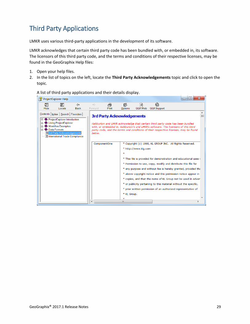
Third Party Applications
LMKR uses various third-party applications in the development of its software.
LMKR acknowledges that certain third party code has been bundled with, or embedded in, its software.
The licensors of this third party code, and the terms and conditions of their respective licenses, may be
found in the GeoGraphix Help files:
1. Open your help files.
2. In the list of topics on the left, locate the Third Party Acknowledgements topic and click to open the
topic.
A list of third party applications and their details display.
30 GeoGraphix® 2017.1 Release Notes
International Trademark Compliance
This application is manufactured or designed using U.S. origin technology and is therefore subject to the
export control laws of the United States. Any use or further disposition of such items is subject to U.S.
law. Exports from the United States and any re-export thereafter may require a formal export license
authorization from the government. If there are doubts about the requirements of the applicable law, it
is recommended that the buyer obtain qualified legal advice. These items cannot be used in the design,
production, use, or storage of chemical, biological, or nuclear weapons, or missiles of any kind.
The ECCNs provided here represent LMKR's opinion of the correct classification for the product today
(based on the original software and/or original hardware). Classifications are subject to change. If you
have any questions or need assistance please contact us at [email protected].
Under the U.S. Export Administration Regulations (EAR), the U.S. Government assigns your organization
or client, as exporter/importer of record, responsibility for determining the correct authorization for the
item at the time of export/import. Restrictions may apply to shipments based on the products, the
customer, or the country of destination, and an export license may be required by the Department of
Commerce prior to shipment. The U.S. Bureau of Industry and Security provides a website to assist you
with determining the need for a license and with information regarding where to obtain help.
The URL is: http://www.bis.doc.gov.
GeoGraphix® 2017.1 Release Notes 31
Definitions
CCATS (Commodity Classification Automated Tracking System) - the tracking number assigned by the
U.S. Bureau of Industry and Security (BIS) to products formally reviewed and classified by the
government. The CCATS provides information concerning export/re-export authorizations, available
exceptions, and conditions.
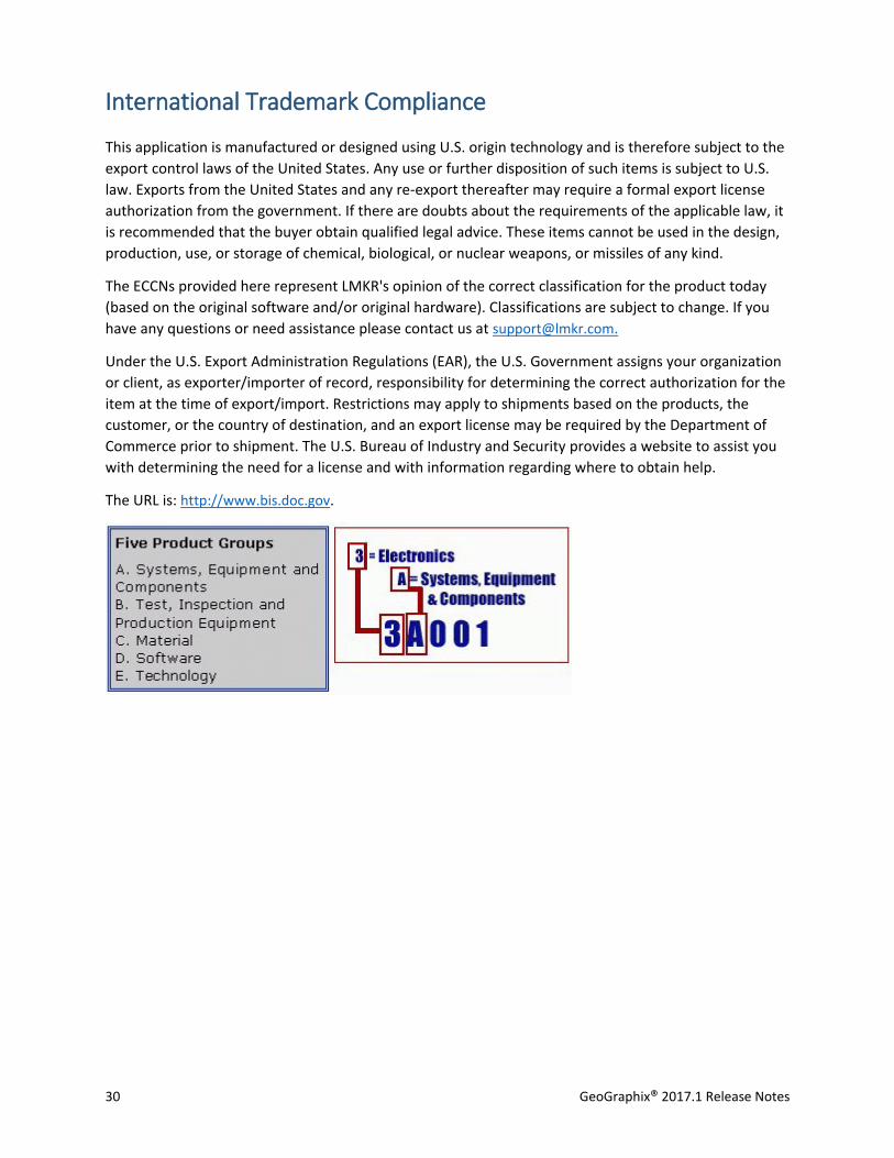
ECCN - Export Control Classification Number - The ECCN is an alpha-numeric code, e.g., 3A001, that
describes a particular item or type of item, and shows the controls placed on that item. The CCL
(Commerce Control List) is divided into ten broad categories, and each category is further subdivided
into five product groups. The CCL is available on the EAR Website.
The ECCN number, License Type, and the CCATS Numbers for this product are included in the table
below. Also included is the date the table was last updated.
Product/Component/R5000 ECCN Number License CCATS Number Last Updated On
GeoGraphix -- - - -
LMKR License Manager 5D002C.1 ENC G055172 6/19/2007
32 GeoGraphix® 2017.1 Release Notes
Contacting LMKR Support
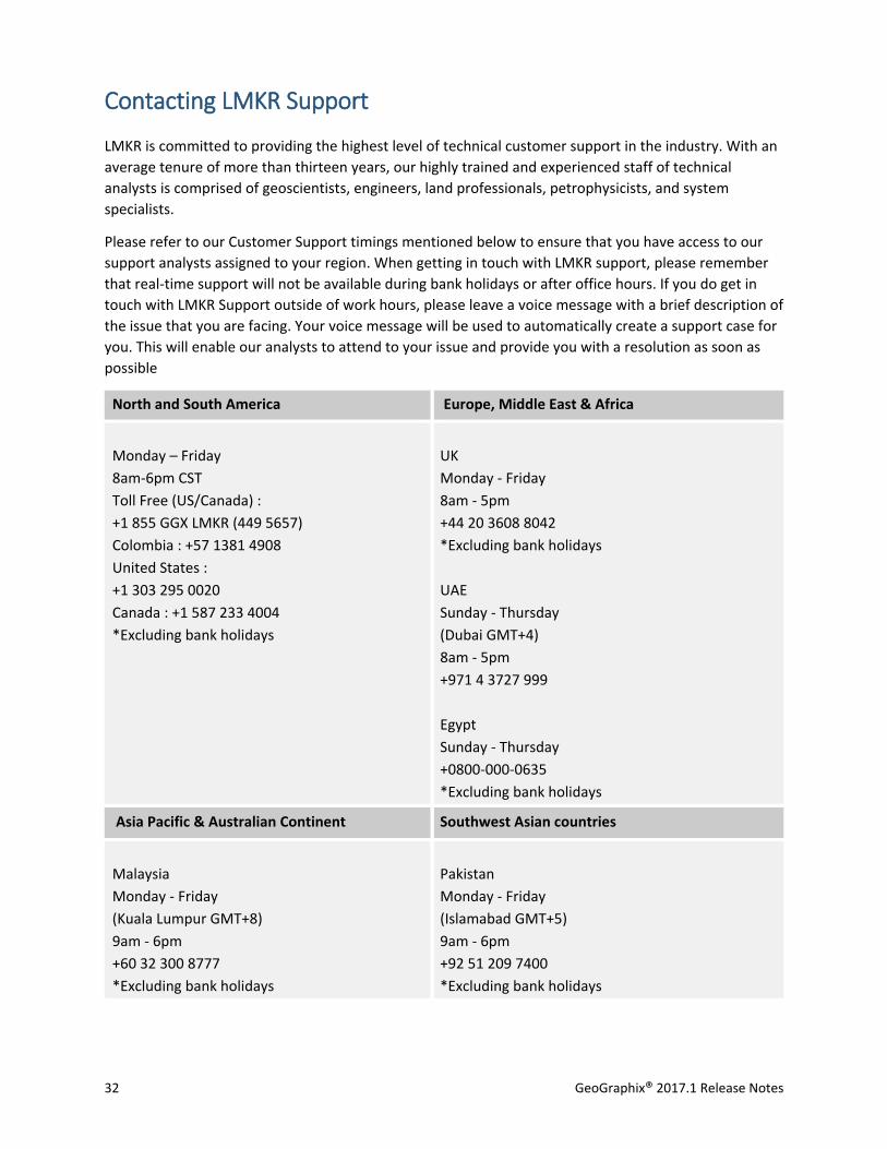
LMKR is committed to providing the highest level of technical customer support in the industry. With an
average tenure of more than thirteen years, our highly trained and experienced staff of technical
analysts is comprised of geoscientists, engineers, land professionals, petrophysicists, and system
specialists.
Please refer to our Customer Support timings mentioned below to ensure that you have access to our
support analysts assigned to your region. When getting in touch with LMKR support, please remember
that real-time support will not be available during bank holidays or after office hours. If you do get in
touch with LMKR Support outside of work hours, please leave a voice message with a brief description of
the issue that you are facing. Your voice message will be used to automatically create a support case for
you. This will enable our analysts to attend to your issue and provide you with a resolution as soon as
possible
North and South America Europe, Middle East & Africa
Monday – Friday
8am-6pm CST
Toll Free (US/Canada) :
+1 855 GGX LMKR (449 5657)
Colombia : +57 1381 4908
United States :
+1 303 295 0020
Canada : +1 587 233 4004
*Excluding bank holidays
UK
Monday - Friday
8am - 5pm
+44 20 3608 8042
*Excluding bank holidays
UAE
Sunday - Thursday
(Dubai GMT+4)
8am - 5pm
+971 4 3727 999
Egypt
Sunday - Thursday
+0800-000-0635
*Excluding bank holidays
Asia Pacific & Australian Continent Southwest Asian countries
Malaysia
Monday - Friday
(Kuala Lumpur GMT+8)
9am - 6pm
+60 32 300 8777
*Excluding bank holidays
Pakistan
Monday - Friday
(Islamabad GMT+5)
9am - 6pm
+92 51 209 7400
*Excluding bank holidays
GeoGraphix® 2017.1 Release Notes 33
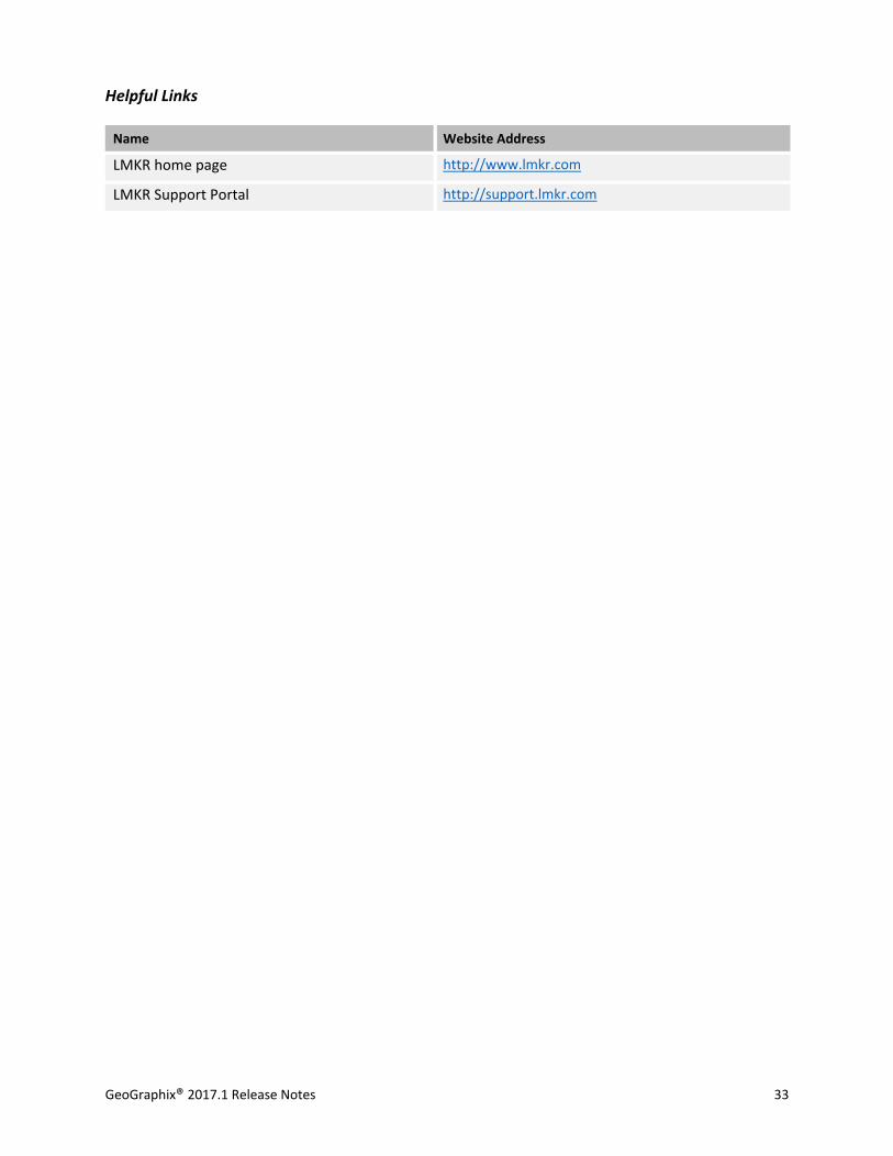
Helpful Links
Name Website Address
LMKR home page http://www.lmkr.com
LMKR Support Portal http://support.lmkr.com