geography subject overview the appleton school
TRANSCRIPT

The Appleton School. Geography Subject Overview.
1 | P a g e
Geography Subject Overview The Appleton School.

The Appleton School. Geography Subject Overview.
2 | P a g e
Subject: Geography
Curriculum Intent (Covering Year 7 to 13)
Vision.
As a department we would like our students to experience a sense of awe and wonder as we explore the
geography of the world and UK. As we move through the geographical journey, students will develop
knowledge and understanding of the processes and interactions that shape the world and closer to home the
UK. We shall promote diversity through the students’ studies developing cultural awareness and respect of
different communities, including our own British values. We shall encourage our students to be active global
citizens through their development of an understanding of the importance of sustainability and the future of
the world. Throughout this process we shall be developing and revisiting geographical skills that students can
then use in later life.

The Appleton School. Geography Subject Overview.
3 | P a g e
What are your aims, linked to the curriculum (National Curriculum and Specification criteria)
The vision and aims of the Geography Department at the Appleton School has been influenced by the purpose and aims of the National
Curriculum (DfE 2013) and the AQA Specifications that we follow at GCSE and A Level, which highlight areas that we feel are particularly
important in the 21st Century. These aims are:
1. Encouraging awe and wonder - “curiosity and fascination about the world” (DfE 2013)
2. Exploring processes and interactions – “understand the processes that give rise to key physical and human geographical features of the
world” (DfE 2013)
3. Developing a sense of personal responsibility - “Students are also encouraged to understand their role in society” (AQA 2016)
4. Increasing locational knowledge of the world - “develop contextual knowledge of the location of globally significant places” (DfE 2013)
5. Developing and mastery of essential geographical skills - “competent in the geographical skills” (DfE 2013)
6. Considering the sustainability of our futures. - “challenge of sustainable resources” (AQA 2016)
How is the curriculum delivered?
The Geography curriculum is divided into themed modules of work which are generally completed within a half term (At Key Stage Three). The
aims are then incorporated into each themed topic.
How is the curriculum assessed?
Assessments are completed after every module testing the key knowledge and skills that have been developed through the unit. At Key Stage
Three our level descriptors provide a clear route of progression for students. At Key Stage Four and Key Stage Five we use the examination
board grade boundaries along with assessments designed using exampro. All of the assessment data is used to inform future teaching and
learning. As well as these end of module assessments, we also have mini assessments where students are given feedback on how to develop
specific knowledge or skills and required to then respond by working on the question again or an extended stretch and challenge question. At
key points in the year determined by the school, year examinations will take place. These examinations will test knowledge and skills across
modules and are again assessed using our own mark schemes (Key Stage Three) or examination mark schemes and grade boundaries (Key
Stage Four and Key Stage Five). This data is recorded on the school MIS (SIMS).

The Appleton School. Geography Subject Overview.
4 | P a g e
How is the curriculum enriched (through speakers/visits/clubs) to generate a love of learning?
The Geography curriculum has been designed so that there are different opportunities for students to learn and explore the subject outside
the classroom.
At Key Stage Four the Head of Department runs the Duke of Edinburgh’s Award, providing students in Years 10 and 11 the opportunity to visit
the local countryside and develop a sense that geography really matters (Miller 2020 – GA Presidential theme) when walking through it.
The Head of department is a member of Geographical Association (GA) and the Royal Geographical Society (RGS) and as such we take the
opportunity to organise lecture afternoons for the Key Stage Four and Key Stage Five students where we show the Monday night lectures to
widen students’ knowledge of the world.
The RGS Geography Ambassadors are also invited into school when they are available to encourage students to think about studying
Geography at university.
What skills and knowledge do students bring with them from Key Stage Two to Year 7?
Locational Knowledge
• Locate the world’s countries, using maps to focus on Europe (including the location of Russia) and North and South America,
concentrating on their environmental regions, key physical and human characteristics, countries, and major cities.
• Name and locate counties and cities of the United Kingdom, geographical regions and their identifying human and physical
characteristics, key topographical features (including hills, mountains, coasts and rivers), and land-use patterns; and understand how
some of these aspects have changed over time
• Identify the position and significance of latitude, longitude, Equator, Northern Hemisphere, Southern Hemisphere, the Tropics of
Cancer and Capricorn, Arctic and Antarctic Circle, the Prime/Greenwich Meridian and time zones (including day and night)
Place knowledge
• Understand geographical similarities and differences through the study of human and physical geography of a region of the United
Kingdom, a region in a European country, and a region within North or South America
The Appleton School. Geography Subject Overview.
5 | P a g e
Human and physical geography
• Describe and understand key aspects of: physical geography, including: climate zones, biomes and vegetation belts, rivers, mountains,
volcanoes and earthquakes, and the water cycle. human geography, including: types of settlement and land use, economic activity
including trade links, and the distribution of natural resources including energy, food, minerals and water
Geographical skills and fieldwork
• Use maps, atlases, globes and digital/computer mapping to locate countries and describe features studied
• Use the eight points of a compass, four and six-figure grid references, symbols and key (including the use of Ordnance Survey maps) to
build their knowledge of the United Kingdom and the wider world
• Use fieldwork to observe, measure, record and present the human and physical features in the local area using a range of methods,
including sketch maps, plans and graphs, and digital technologies.
We use a baseline assessment test at the start of Year 7 to test the range of geographical skills and knowledge that the students are coming
into our department with and make suitable adjustments to our teaching as a result in term 1 in the module “What is a geographer?”
What skills and knowledge do students bring with them from Year 7 to Year 8?
Contextual world knowledge
• Locate and name the world’s continents and oceans
• Locate and name countries in Europe, North and South America
• Begin to identify human and physical features of localities – Holderness, Southampton, Helvellyn, Seaford, Scarborough
• Identify human and physical features of a locality – Teesside
• Identify human and physical features of a locality – Scarborough
• Understand the growth of manufacturing in China
• Weather and climate of the UK
• Locate Russia and its surrounding countries
• Identify key features of Russia’s physical landscape, climate, environments, population distribution, economy,
• Identify human and physical features of a locality – River Tees
• Locate the world’s major river basins

The Appleton School. Geography Subject Overview.
6 | P a g e
Competence in geographical enquiry and skills
• Locate and describe places using latitude and longitude
• Demonstrate ability to use Ordnance Survey map skills, scale, grid references, height, direction, with aerial photos
• Compare an OS map with an aerial photo to analyse the location of an oil refinery
• Communicate views about the need to use natural resources sustainably
• Use new geographical terminology
• Use statistical data to draw a graph to show how the UK economy has evolved
• Decision making – locating a factory
• Comparing an OS map with an aerial photo to identify location factors for a car plant
• Use new geographical terminology – economy
• Use the synoptic code, weather charts and satellites to analyse weather patterns
• Interpret and draw climate graphs for the UK
• Interpret climate maps for the UK and world
• Use new geographical terminology – weather and climate
• Interpret and draw climate graphs for Russia
• Interpret climate maps for Russia
• Use atlas maps and photos to investigate Russia
• Use GiS/Google Earth to investigate Russia
• Geographical enquiry – using range of geographical data
• Comparing an OS map with an aerial photo to identify river features, and how people use rivers
• Use an OS map to draw a cross-section of a river valley
• Use ArcGIS to investigate the long profile of the River Tees
What skills and knowledge do students bring with them from Year 8 to Year 9?
Contextual world knowledge
• Understand global patterns of development, locating countries in different states of development
• Identify development priorities for Bolivia
• Consider the state of development in Nepal

The Appleton School. Geography Subject Overview.
7 | P a g e
• Identify regional inequality in the UK
• Understand the global distribution of population, and location of the world’s major cities
• Impact of population change in Southampton 1801 to present
• Population control strategies in Russia and China
• Identify human and physical features of a locality – Holderness coast
• Locate Asia and its countries
• Identify key features of Asia ’s physical landscape, climate, environments, population distribution, economy
• Understand aspects of the human geography of India and China, Nepal
• Locate the global distribution of volcanoes, earthquakes, mountain belts and plate boundaries
• Locate and investigate natural disasters in Guatemala, Turkey, Nepal
• Global patterns of climate change and greenhouse gas emissions
• Antarctica the frozen continent
• Consequences of climate change in the UK
Competence in geographical enquiry and skills
• Use Development Compass Rose to classify indicators of development
• Interpret statistics, Dollar Street website and choropleth maps to investigate patterns of development at different scales
• Communicate understanding of development and use new terminology
• Interpret statistics, graphs models population density map, population pyramids to investigate population
• Consider decisions people make to change
• Identify the latitude and longitude of cities
• Compare OS maps of different scales
• Use a range of historical data
• Identify change comparing 1890 OS maps with current OS map
• Comparing an OS map with aerial and ground level photos to identify coastal features, and how people try to manage the coast
• Consider different viewpoints and justify decisions about coastal management
• Interpret climate maps for Asia
The Appleton School. Geography Subject Overview.
8 | P a g e
• Use atlas maps and photos to investigate Asia
• Interpret statistics, graphs, population density map, population pyramids to investigate population change
• Consider different points of view and decisions people make to change
• Apply understanding of migration and urbanization to analyse a range of geographical information about Karnataka
• Interpret atlas maps, eye witness accounts, scientific evidence, public information material to investigate plate tectonics
• Investigate controversial issues
• Consider a range of evidence of climate change
• Consider and critically reflect on different viewpoints detecting bias
• Use a wide range of geographical data in this unit and those throughout the book marked with cc symbol to identify and classify the
causes and consequences of climate change
• Use of GiS to identify flood risk in the UK
• Class debate presenting three options for the future
• Consider future actions as a geographer
What skills and knowledge do students bring with them from Year 9 to Year 10?
• Natural hazards pose major risks to people and property.
• Earthquakes and volcanic eruptions are the result of physical processes.
• The effects of, and responses to, a tectonic hazard vary between areas of contrasting levels of wealth.
• Management can reduce the effects of a tectonic hazard
• Global atmospheric circulation helps to determine patterns of weather and climate.
• Tropical storms (hurricanes, cyclones, typhoons) develop as a result of particular physical conditions.
• Tropical storms have significant effects on people and the environment.
• The UK is affected by a number of weather hazards.
• Extreme weather events in the UK have impacts on human activity.
• Climate change is the result of natural and human factors and has a range of effects.
• Managing climate change involves both mitigation (reducing causes) and adaptation (responding to change).
• The UK has a range of diverse landscapes.
• The coast is shaped by a number of physical processes.

The Appleton School. Geography Subject Overview.
9 | P a g e
• Distinctive coastal landforms are the result of rock type, structure and physical processes.
• Different management strategies can be used to protect coastlines from the effects of physical processes.
• The shape of river valleys changes as rivers flow downstream.
• Distinctive fluvial landforms result from different physical processes.
• Different management strategies can be used to protect river landscapes from the effects of flooding.
• Use and interpret OS maps at a range of scales, including 1:50 000 and 1:25 000 and other maps appropriate to the topic
• Use and understand coordinates – four and six-figure grid references
• Use and understand scale, distance and direction – measure straight and curved line distances using a variety of scales
• Use and understand gradient, contour and spot height
• Identify basic landscape features and describe their characteristics from map evidence
• Identify major relief features on maps and relate cross-sectional drawings to relief features
• Draw inferences about the physical and human landscape by interpretation of map evidence, including patterns of relief, drainage,
settlement, communication and land-use
• Interpret cross sections and transects of physical and human landscapes
• Describe the physical features as they are shown on large scale maps of two of the following landscapes – coastlines, fluvial landscapes
• Infer human activity from map evidence, including tourism
What skills and knowledge do students bring with them from Year 10 to Year 11?
• Numerical and statistical information
• Ecosystems exist at a range of scales and involve the interaction between biotic and abiotic components.
• Tropical rainforest ecosystems have a range of distinctive characteristics.
• Deforestation has economic and environmental impacts.
• Tropical rainforests need to be managed to be sustainable.
• Hot desert ecosystems have a range of distinctive characteristics.
• Development of hot desert environments creates opportunities and challenges.
• Areas on the fringe of hot deserts are at risk of desertification.
• A growing percentage of the world’s population lives in urban areas.
• Urban growth creates opportunities and challenges for cities in LICs and NEEs.

The Appleton School. Geography Subject Overview.
10 | P a g e
• Urban change in cities in the UK leads to a variety of social, economic and environmental opportunities and challenges.
• Urban sustainability requires management of resources and transport.
• Use and understand coordinates – latitude and longitude
• Recognise and describe distributions and patterns of both human and physical features
• Maps based on global and other scales may be used and students may be asked to identify and describe significant features of the
physical and human landscape on them, e.g. population distribution, population movements, transport networks, settlement layout,
relief and drainage
• Be able to compare maps
• Sketch maps: draw, label, understand and interpret
• Photographs: use and interpret ground, aerial and satellite photographs
• Describe human and physical landscapes (landforms, natural vegetation, land-use and settlement) and geographical phenomena from
photographs
• Draw sketches from photographs
• Label and annotate diagrams, maps, graphs, sketches and photographs.
• Select and construct appropriate graphs and charts to present data, using appropriate scales – line charts, bar charts, pie charts,
pictograms, histograms with equal class intervals, divided bar, scattergraphs, and population pyramids
• Suggest an appropriate form of graphical representation for the data provided
• Complete a variety of graphs and maps – choropleth, isoline, dot maps, desire lines, proportional symbols and flow lines
• Use and understand gradient, contour and value on isoline maps
• Plot information on graphs when axes and scales are provided
• Interpret and extract information from different types of maps, graphs and charts, including population pyramids, choropleth maps,
flow-line maps, dispersion graphs.
What skills and knowledge do students bring with them from Key Stage Four to Year 12?
• All of the above plus…
• Analyse the inter-relationship between physical and human factors on maps and establish associations between observed patterns on
thematic maps.

The Appleton School. Geography Subject Overview.
11 | P a g e
• There are global variations in economic development and quality of life.
• Various strategies exist for reducing the global development gap.
• Some LICs and NEEs are experiencing rapid economic development which leads to significant social, environmental and cultural change.
• Major changes in the economy of the UK have affected, and will continue to affect, employment patterns and regional growth.
• Food, water and energy are fundamental to human development.
• The changing demand and provision of resources in the UK create opportunities and challenges.
• Demand for energy resources is rising globally but supply can be insecure, which may lead to conflict.
• Different strategies can be used to increase energy supply.
• Be able to compare maps
• Sketch maps: draw, label, understand and interpret
• Photographs: use and interpret ground, aerial and satellite photographs
• Describe human and physical landscapes (landforms, natural vegetation, land-use and settlement) and geographical phenomena from
photographs
• Draw sketches from photographs
• Label and annotate diagrams, maps, graphs, sketches and photographs.
• Demonstrate an understanding of number, area and scales, and the quantitative relationships between units
• Design fieldwork data collection sheets and collect data with an understanding of accuracy, sample size and procedures, control groups
and reliability
• Understand and correctly use proportion and ratio, magnitude and frequency
• Draw informed conclusions from numerical data.
• Use appropriate measures of central tendency, spread and cumulative frequency (median, mean, range, quartiles and inter-quartile
range, mode and modal class)
• Calculate percentage increase or decrease and understand the use of percentiles
• Describe relationships in bivariate data: sketch trend lines through scatter plots, draw estimated lines of best fit, make predictions,
interpolate and extrapolate trends
• Be able to identify weaknesses in selective statistical presentation of data.
• Use of qualitative and quantitative data from both primary and secondary sources to obtain, illustrate, communicate, interpret, analyse
and evaluate geographical information.

The Appleton School. Geography Subject Overview.
12 | P a g e
• Identify questions and sequences of enquiry
• Write descriptively, analytically and critically
• Communicate their ideas effectively
• Develop an extended written argument
• Draw well-evidenced and informed conclusions about geographical questions and issues.
What skills and knowledge do students bring with them from Year 12 to Year 13?
• Concept of systems based approach to geography.
• Skills and Knowledge from Water and Carbon, coastal landscapes and Hazards modules.
• Independence work from NEA

The Appleton School. Geography Subject Overview.
13 | P a g e

The Appleton School. Geography Subject Overview.
14 | P a g e
What will students study?
Term 1 Term 2 Term 3 Term 4 Term 5 Term 6
Year 7 Unit: What is a Geographer? In this module we shall explore what it means to be a geographer. We shall investigate the difference between physical and human geography and learn about the countries of Europe and North and South America. We shall understand how we locate places in the world including latitude and longitude and grid references. We shall also develop our map skills. Prior learning to be revisited. Location of Continents Countries in N&S America, Asia Latitude and Longitude. 4 and 6 Fig Grid references. How will learning from this unit be developed in the next unit? Using Lat and Long to locate biomes.
Unit: How do we use our planet as a natural resource?
In this unit we shall
investigate the different
elements that make up
our planet and how rocks
are formed and used in
our everyday lives. We
study the world’s biomes
and look at the features
of rainforests. We study
how the world uses
natural resources like oil
and gas and understand
the difference between
renewable and non-
renewable resources. Prior learning to be revisited. Climate zones Biomes Water cycle Natural resources How will learning from this unit be developed in the next unit? Trading of oil and gas. Climate in weather module
Unit: What is an
economy, from local to
global?
In this unit we shall
investigate economic
activities and what they
are like at different
scales, from local to
global. We shall explore
how jobs can be arranged
into groups or sectors
and how these have
changed over time. We
explore what trade is and
how it has become
global, and how the UK
economy has developed
and how our links with
the world have grown. Prior learning to be revisited. Economic activity and trade inks How will learning from this unit be developed in the next unit? Different jobs linked to weather and climate. Trade links to Rivers module.
Unit: What is weather
and climate?
In this module we shall
learn the difference
between weather and
climate, and the
elements that make up
the two. We shall learn
how to record and
present weather data.
We shall also consider
the different climate
zones of the world. Prior learning to be revisited. Climate Zones How will learning from this unit be developed in the next unit? Weather and climate of Russia Climate graphs
Unit: The geography of
Russia.
We learn where Russia is located and explore the physical and human geography of Russia, such as the weather and climate of Russia and how this affects where the population is distributed. We conclude the unit by investigating the global connections Russia has Prior learning to be revisited. Mapping skills. Mountains Latitude and Longitude How will learning from this unit be developed in the next unit? Linking rivers in Russia to work on rivers.
Unit: Why are rivers
important?
We begin by studying the
water cycle and how
rivers are formed. We
explore how erosion
transportation and
deposition create
different landforms along
the river. We learn how
to recognise these
landforms from O/S
maps. We conclude by
discussing how rivers are
important for people. Prior learning to be revisited. O/S Maps Rivers Water cycle How will learning from this unit be developed in the next unit? Location of cities – link back to importance of rivers.

The Appleton School. Geography Subject Overview.
15 | P a g e
Year 8 Unit: One planet, many
people. How are
populations changing?
In this unit we explore the distribution and density of populations globally and how this has changed over time. We investigate how countries like Russia and China try to modify their population characteristics. Migration and the affect this has, on areas such as the countryside and cities is also investigated. Prior learning to be revisited. Human features (city etc) Russia Unit How will learning from this unit be developed in the next unit? Population DTM and development
Unit: What is
Development?
We learn what the term development means and how it is measured across the globe. We explore inequalities across the globe and understand how actions by individual governments and communities can help encourage development Prior learning to be revisited. Use of Maps Locating Continents How will learning from this unit be developed in the next unit? Considering why some countries can afford coastal management and others not.
Unit: What happens
when the land meets
the sea?
We shall develop an
understanding of how
erosion deposition
and transportation
create and change
coastal landforms
over time. We discuss
how the coast is used
by people and how
this leads to different
coastal management
strategies. We
continue to practice
our map skills by
identifying different
coastal landforms. Prior learning to be revisited. Physical Geography – Sea Ocean Development How will learning from this unit be developed in the next unit? Coastal nature of Asia
Unit: Diverse and dynamic:
How is Asia being
transformed.
We investigate the diverse
physical and human
geography of Asia and how
this leads to Asia being
considered a continent of
change. We consider how
Asia is connected with the
rest of the world. Prior learning to be revisited. Continents of the world Population Weather and Climate Trade How will learning from this unit be developed in the next unit? Examples of Natural hazards in Asia
Unit: Can we ever know
enough about
earthquakes and
volcanoes to live safely?
We shall study the theory
of plate tectonics and
explore how earthquakes
and volcanoes are linked
to plate tectonics, and
how they are hazards for
people living nearby. We
shall discover how
scientists attempt to
predict, manage and
prevent these hazards. Prior learning to be revisited. Physical Geography Population Distribution / density Development How will learning from this unit be developed in the next unit?
Unit: What is the future
for the planet? A
geographer’s view.
In this unit we shall investigate the topic of climate change, and explore why it is a controversial topic. We shall look at the evidence for climate change, and the physical and human causes of climate change through history. We shall discuss the possible consequences of climate change for our lives in the future. Prior learning to be revisited. Population distribution and density Coasts Weather/climate How will learning from this unit be developed in the next unit? Glaciation - linked to climate change

The Appleton School. Geography Subject Overview.
16 | P a g e
Year 9 Unit 12. What are the opportunities and challenges facing Africa? This unit introduces the challenges and opportunities facing Africa. It starts with the danger of the single story, encouraging pupils to challenge stereotypical views of this diverse continent. Pupils will explore the physical geography and colonial history of Africa to give them a grounding upon which to build when studying the development of African countries.
Prior Learning to be revisited.
KS2 Knowledge of Africa.
Climate zones
Map Skills
Population
How will learning from this unit be developed in the next unit? It will not, but will knowledge will be used at GCSE level.
How does Ice change the World?
This unit further progresses pupil understanding of the processes of erosion, deposition and transportation.
Prior Learning to be revisited.
It builds on previous physical geography Units 6 and 9, but now applied to a glacial context
How will learning from this unit be developed in the next unit? It will not, but knowledge will be revisited when GCSE students discuss climate change
Natural hazards.
Natural hazards pose major risks to people and property. Earthquakes and volcanic eruptions are the result of physical processes. The effects of, and responses to, a tectonic hazard vary between areas of contrasting levels of wealth. Management can reduce the effects of a tectonic hazard.
Prior learning to be revisited.
Year 8 Earthquakes and volcanoes work.
How will learning from this unit be developed in the next unit?
Discussion on Tropical storms
Weather hazards.
Global atmospheric circulation helps to determine patterns of weather and climate. Tropical storms (hurricanes, cyclones, typhoons) develop as a result of particular physical conditions. Tropical storms have significant effects on people and the environment.
Revision and interleaving of Year 9
Exam Week - Jan: Prior learning to be revisited. Natural hazards Module How will learning from this unit be developed in the next unit? Builds on concept of weather.
River Landscapes in the UK.
The UK has a range of diverse landscapes. The shape of river valleys changes as rivers flow downstream. Distinctive fluvial landforms result from different physical processes. Different management strategies can be used to protect river landscapes from the effects of flooding.
Revision and interleaving of Year 7 rivers module
Exam Week - May
Fieldwork Rivers: Prior learning to be revisited. Rivers module in Year 7
Urban issues and challenges.
A growing percentage of the world’s population lives in urban areas. Urban growth creates opportunities and challenges for cities in LICs and NEEs. Requires management of resources and transport.
Prior learning to be revisited. Population unit Year 8 How will learning from this unit be developed in the next unit? Cities and issues faced.
Paper Three Pre-release.
2018 Pre -release
Prior learning to be revisited. How will learning from this unit be developed in the next unit? More a case of developing enquiry skills for future modules.

The Appleton School. Geography Subject Overview.
17 | P a g e

The Appleton School. Geography Subject Overview.
18 | P a g e
Year 10 Unit: Ecosystems
Ecosystems exist at a range of scales and involve the interaction between biotic and abiotic components.
Tropical Rainforests.
Tropical rainforest ecosystems have a range of distinctive characteristics. Deforestation has economic and environmental impacts. Tropical rainforests need to be managed to be sustainable.
Prior learning to be revisited. Natural resources Year 7 Weather and Climate How will learning from this unit be developed in the next unit? Adaptations
Unit: Coastal Landscapes in the UK.
The coast is shaped by a number of physical processes. Distinctive coastal landforms are the result of rock type, structure and physical processes. Different management strategies can be used to protect coastlines from the effects of physical processes Prior learning to be revisited. Year 8 coasts work. Hot deserts. Hot desert ecosystems. Development of hot deserts. Explore opportunities and challenges and the risk of desertification.
Revision and interleaving of Year 9 and 10 topics
Prior learning to be revisited. Adaptations Asia How will learning from this unit be developed in the next unit? Population distributions.
Unit: Urban issues and challenges UK. Urban change in cities in the UK leads to a variety of social, economic and environmental opportunities and challenges. Urban sustainability Revision and interleaving of Year 9 and 10 topics Exam Week - March: Prior learning to be revisited. Graphical skills Population module How will learning from this unit be developed in the next unit? Jobs in cities.
Unit: Changing Economic World.
There are global variations in economic development and quality of life. Various strategies exist for reducing the global development gap. Environmental and cultural change.
Prior learning to be revisited. Issues in different levels of development. How will learning from this unit be developed in the next unit? Economic activity in LICs and HICs
Unit: Changing Economic World.
Some LICs and NEEs are experiencing rapid economic development which leads to significant social. Prior learning to be revisited. Development How will learning from this unit be developed in the next unit? Future development needs in LICs and HICs
Fieldwork - Human.
Revision and interleaving of Year 9 and 10 topics
Unit: Changing Economic World.
Major changes in the economy of the UK have affected, and will continue to affect,
Revision and interleaving of Year 9 and 10 topics
Prior learning to be revisited. Development UK Cities Economy Year 8
Exam Week - June
The Appleton School. Geography Subject Overview.
19 | P a g e
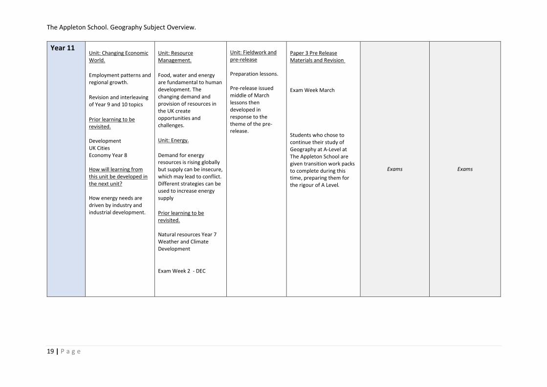
Year 11 Unit: Changing Economic World.
Employment patterns and regional growth.
Revision and interleaving of Year 9 and 10 topics
Prior learning to be revisited. Development UK Cities Economy Year 8 How will learning from this unit be developed in the next unit? How energy needs are driven by industry and industrial development.
Unit: Resource Management.
Food, water and energy are fundamental to human development. The changing demand and provision of resources in the UK create opportunities and challenges.
Unit: Energy.
Demand for energy resources is rising globally but supply can be insecure, which may lead to conflict. Different strategies can be used to increase energy supply
Prior learning to be revisited. Natural resources Year 7 Weather and Climate Development
Exam Week 2 - DEC
Unit: Fieldwork and pre-release Preparation lessons. Pre-release issued middle of March lessons then developed in response to the theme of the pre-release.
Paper 3 Pre Release Materials and Revision
Exam Week March
Students who chose to continue their study of Geography at A-Level at The Appleton School are given transition work packs to complete during this time, preparing them for the rigour of A Level.
Exams Exams

The Appleton School. Geography Subject Overview.
20 | P a g e

The Appleton School. Geography Subject Overview.
21 | P a g e
Year 12 Unit: 3.1.1 Water and carbon cycles The major stores of water and carbon at or near the Earth’s surface and the dynamic cyclical relationships associated with them. These are major elements in the natural environment and understanding them is fundamental to many aspects of physical geography. Prior learning to be revisited. Key Stage Three water cycle How will learning from this unit be developed in the next unit? Systems approach used throughout A-Level
Unit: 3.1.1 Water and carbon cycles The major stores of water and carbon at or near the Earth’s surface and the dynamic cyclical relationships associated with them. These are major elements in the natural environment and understanding them is fundamental to many aspects of physical geography. Prior learning to be revisited. Key Stage Three water cycle How will learning from this unit be developed in the next unit? Systems approach used throughout A-Level
Unit: 3.1.3 Coastal systems and landscapes Coastal zones, which are dynamic environments in which landscapes develop by the interaction of winds, waves, currents and terrestrial and marine sediments. The operation and outcomes of fundamental geomorphological processes and their association with distinctive landscapes are readily observable. Prior learning to be revisited. Key Stage Three coasts and GCSE Coasts How will learning from this unit be developed in the next unit? Systems approach used throughout A-Level
Unit: 3.1.3 Coastal systems and landscapes Coastal zones, which are dynamic environments in which landscapes develop by the interaction of winds, waves, currents and terrestrial and marine sediments. The operation and outcomes of fundamental geomorphological processes and their association with distinctive landscapes are readily observable. Prior learning to be revisited. Key Stage Three coasts and GCSE Coasts How will learning from this unit be developed in the next unit? Systems approach used throughout A-Level
Unit: Hazards Lithosphere and the atmosphere, which intermittently but regularly present natural hazards to human populations, often in dramatic and sometimes catastrophic fashion. By exploring the origin and nature of these hazards and the various ways in which people respond to them, students are able to engage with many dimensions of the relationships between people and the environments they occupy Prior learning to be revisited. Key Stage Three and Four Tectonics. How will learning from this unit be developed in the next unit? Systems approach used throughout A-Level
Unit: NEA The independent investigation Prior learning to be revisited. Whole of unit covered so far as well as fieldwork in GCSE How will learning from this unit be developed in the next unit? Independence and study skills.

The Appleton School. Geography Subject Overview.
22 | P a g e
Year 13 Unit: 3.2.1 Global systems and global governance Globalisation – the economic, political and social changes associated with technological and other driving forces which have been a key feature of global economy and society in recent decades. Prior learning to be revisited. Globalisation at GCSE How will learning from this unit be developed in the next unit? Links of globalisation to how places have changed.
Unit: Population and the Environment Explore the relationships between key aspects of physical geography and population numbers, population health and well-being, levels of economic development and the role and impact of the natural environment. Prior learning to be revisited. Global Governance How will learning from this unit be developed in the next unit? N/A
Unit: Changing Places People's engagement with places, their experience of them and the qualities they ascribe to them, all of which are of fundamental importance in their lives. Prior learning to be revisited. Global Systems Urban Issues at GCSE How will learning from this unit be developed in the next unit? Consider the relationship between health and places
Unit: Revision of areas of weakness and completion of NEA
Exams Exams
The Appleton School. Geography Subject Overview.
23 | P a g e
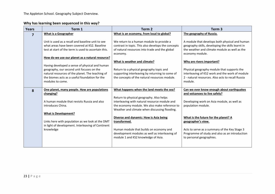
Why has learning been sequenced in this way?
Years Term 1 Term 2 Term 3
7 What is a Geographer Unit is used as a recall and baseline unit to see what areas have been covered at KS2. Baseline test at start of the term is used to ascertain this. How do we use our planet as a natural resource? Having developed a sense of physical and human geography, our second unit focuses on the natural resources of the planet. The teaching of the biomes acts as a useful foundation for the modules to come.
What is an economy, from local to global? We return to a human module to provide a contrast in topic. This also develops the concepts of natural resources into trade and the global economy. What is weather and climate? Return to a physical geography topic and supporting interleaving by returning to some of the concepts of the natural resources module.
The geography of Russia. A module that develops both physical and human geography skills, developing the skills learnt in the weather and climate module as well as the economy module. Why are rivers important? Physical geography module that supports the interleaving of KS2 work and the work of module 2 - natural resources. Also acts to recall Russia module.
8 One planet, many people. How are populations changing? A human module that revisits Russia and also introduces China. What is Development? Links here with population as we look at the DMT in light of development. Interleaving of Continent knowledge
What happens when the land meets the sea? Return to physical geography. Also helps interleaving with natural resource module and the economy module. We also make reference to Weather and climate when discussing flooding. Diverse and dynamic: How is Asia being transformed. Human module that builds on economy and development modules as well as interleaving of module 1 and KS2 knowledge of Asia.
Can we ever know enough about earthquakes and volcanoes to live safely? Developing work on Asia module, as well as population module. What is the future for the planet? A geographer’s view. Acts to serve as a summary of the Key Stage 3 Programme of study and also as an introduction to personal geographies.

The Appleton School. Geography Subject Overview.
24 | P a g e
9 What are the opportunities and challenges facing Africa? To explore the continent in readiness for the Africa GCSE case studies. How does Ice change the World? Completion of Key Stage Three and also provides a content for climate change work next term
Tectonic Hazards Develops on the module taught in Year 8 and acts as a transition module for the GCSE course. Weather in the UK Opportunity to conduct fieldwork in the school grounds on windspeed. Extreme Weather Continue with the physical geography theme – looking at extreme weather – often linked to local storm and flooding at this point in the year Climate Change Links with weather and climate and also helpful to recall Year 9 work.
River Landscapes Recall of Year 7 work and building on this. Opportunity to visit local rivers Physical Fieldwork At this point in the year as it recalls the work in yr 9 and allows time to produce a NEA style piece of work for assessment and to build skills for A Level. DME – Paper 3 End of Year DME exercise to develop skills needed for Year 11 Paper 3 work.
10 Ecosystems Linking to weather and climate modules and also the work we completed in Year 7. Possible local visit to a woodland. Coastal Landscapes in the UK Develops on the module taught in Year 8 and acts as a transition module for the GCSE course. Tropical Rainforests Linking back to Climate change and also weather and climate and ecosystems. Hot Deserts Contrast to Tropical rainforests, while also revisiting key concepts in that module.
Urban Issues and challenges First human geography module. Links back to work completed in Year 8 so helps with interleaving. Also links back to the topics of coasts and ecosystems.
Changing Economic World. Links back to the economy module in Year 7 and the development module of Year 8. We also revisit the issues covered in the last module as we link urban issues with levels of development. Human Geography Fieldwork. End the year with another opportunity to complete fieldwork – Human geography fieldwork looking at Chelmsford.

The Appleton School. Geography Subject Overview.
25 | P a g e
11 Changing Economic World.
Continue to work on Economic world.
Resource Management Linking back to many of the topics at GCSE as well as Key Stage Three. Also helps to develop the geographical skills such as mapping and analysing maps as well. Energy Follows on from the resource management section.
Paper 3 Pre-Release Needed here as Pre-Release is available at the end of March. Fieldwork Recap Time to recall fieldwork information and to prepare for exams. Revision
12 Water and Carbon Cycles Start as it helps to develop the central theme and concept of a systems approach to geography.
Coastal Systems and Landscapes Builds on systems approach to geography
Hazards A good time to have this unit as we can then draw on the concepts taught in previous modules such as concept of lived experience and who decides to make decisions. NEA Introduction lessons and then students research their own topics and collect data during the summer months.
13 Global Systems and Global Governance One of the harder topics on the spec and needs to be understood through examples, and coasts and water and carbon act as a good feed into the module in that regard. Also acts as a good module to signpost in later modules. Population and the Environment Ideal to have this here as it acts as a good recall of coasts and water and carbon as well as developing on ideas from Global systems.
Population and the Environment Ideal to have this here as it acts as a good recall of coasts and water and carbon as well as developing on ideas from Global systems. Changing Places Ideal to have after Population and environment so we can develop concepts taught there into examples of the nature or place.
Exams
The Appleton School. Geography Subject Overview.
26 | P a g e
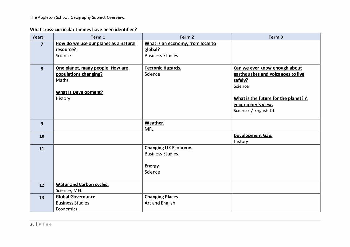
What cross-curricular themes have been identified?
Years Term 1 Term 2 Term 3
7 How do we use our planet as a natural resource? Science
What is an economy, from local to global? Business Studies
8 One planet, many people. How are populations changing? Maths What is Development? History
Tectonic Hazards. Science
Can we ever know enough about earthquakes and volcanoes to live safely? Science What is the future for the planet? A geographer’s view. Science / English Lit
9 Weather. MFL
10 Development Gap. History
11
Changing UK Economy. Business Studies. Energy Science
12 Water and Carbon cycles. Science, MFL
13 Global Governance Business Studies Economics.
Changing Places Art and English
The Appleton School. Geography Subject Overview.
27 | P a g e
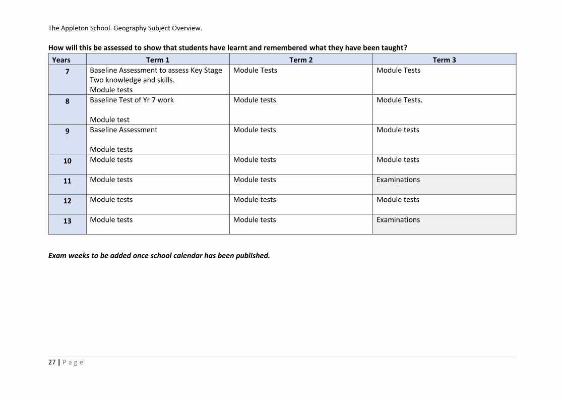
How will this be assessed to show that students have learnt and remembered what they have been taught?
Years Term 1 Term 2 Term 3
7 Baseline Assessment to assess Key Stage Two knowledge and skills. Module tests
Module Tests
Module Tests
8 Baseline Test of Yr 7 work Module test
Module tests Module Tests.
9 Baseline Assessment Module tests
Module tests Module tests
10 Module tests
Module tests Module tests
11 Module tests
Module tests
Examinations
12 Module tests
Module tests Module tests
13 Module tests
Module tests
Examinations
Exam weeks to be added once school calendar has been published.

The Appleton School. Geography Subject Overview.
28 | P a g e
Extra-curricular opportunities during the year.
Years Term 1 Term 2 Term 3
7 GA World Wise Local Quiz Fair Trade Fortnight. World Book Day
RGS Geographer of the Year Competition.
8 GA World Wise Local Quiz Fair Trade Fortnight. World Book Day.
RGS Geographer of the Year Competition.
9 GA World Wise Local Quiz Fair Trade Fortnight. RGS Geographer of the Year Competition.
10 GA World Wise Local Quiz Fair Trade Fortnight. RGS Geographer of the Year Competition.
11 GA World Wise Local Quiz Examination webinars
Fair Trade Fortnight. Examination webinars Revision days.
12 GA East London Branch Lectures (Queen Mary University of London.) RGS Monday Night lectures
GA East London Branch Lectures (Queen Mary University of London.) Hazards Day RGS Monday Night lectures
RGS Geographer of the Year Competition. RGS Monday Night lectures
13 GA East London Branch Lectures (Queen Mary University of London.) RGS Monday Night lectures Examination webinars
GA East London Branch Lectures (Queen Mary University of London.) Revision workshops. RGS Monday Night lectures

The Appleton School. Geography Subject Overview.
29 | P a g e
What will students be expected to know and remember?
Skills.
Years Term 1 Term 2 Term 3
7 • Locate and describe places using latitude and longitude.
• Demonstrate ability to use Ordnance Survey map skills, scale, grid references, height, direction, with aerial photos
• Compare an OS map with an aerial photo to
analyse the location of an oil refinery
• Communicate views about the need to use
natural resources sustainably
• Use new geographical terminology
• Use statistical data to draw a graph to show how the UK economy has evolved
• Decision making – locating a factory • Comparing an OS map with an aerial photo to
identify location factors for a car plant
• Use new geographical terminology – economy
• Use the synoptic code, weather charts and
satellites to analyse weather patterns
• Interpret and draw climate graphs for the UK • Interpret climate maps for the UK and world • Use new geographical terminology – weather and
climate
• • Interpret and draw climate graphs for Russia • Interpret climate maps for Russia • Use atlas maps and photos to investigate Russia • Use GiS/Google Earth to investigate Russia • Geographical enquiry – using range of
geographical data. • Comparing an OS map with an aerial photo to
identify river features, and how people use rivers • Use an OS map to draw a cross-section of a river
valley • Use ArcGIS to investigate the long profile of the
River Tees
8 • Use Development Compass Rose to classify indicators of development
• Interpret statistics, Dollar Street website and choropleth maps to investigate patterns of
development at different scales
• Communicate understanding of development and use new
• Interpret statistics, graphs models population density map, population
pyramids to investigate population
• Consider decisions people make to change • Identify the latitude and longitude of cities • Compare OS maps of different scales • Use a range of historical data • Identify change comparing 1890 OS maps
with current OS map
• Comparing an OS map with aerial and ground
level photos to identify coastal features, and
how people try to manage the coast
• Consider different viewpoints and justify decisions about coastal management
• Interpret climate maps for Asia • Use atlas maps and photos to investigate
Asia • Interpret statistics, graphs, population
density map, population pyramids to investigate population change
• Consider different points of view and decisions people make to change
• Apply understanding of migration and urbanization to analyse a range of geographical information about Karnataka
• Interpret atlas maps, eye witness accounts,
scientific evidence, public information material to investigate plate tectonics
• Investigate controversial issues • Consider a range of evidence of climate
change • Consider and critically reflect on different
viewpoints detecting bias • Use a wide range of geographical data in this
unit and those throughout the book marked with cc symbol to identify and classify the causes and consequences of climate change
• Use of GiS to identify flood risk in the UK • Class debate presenting three options for the
future • Consider future actions as a geographer

The Appleton School. Geography Subject Overview.
30 | P a g e
9 • use and interpret OS maps at a range of scales, including 1:50 000 and 1:25 000 and other maps appropriate to the topic
• use and understand coordinates – four and six-figure grid references
• use and understand scale, distance and direction – measure straight and curved line distances using a variety of scales
• identify basic landscape features and describe their characteristics from map evidence
• identify major relief features on maps and relate cross-sectional drawings to relief features
• use and understand gradient, contour and spot height
• draw inferences about the physical and human landscape by interpretation of map evidence, including patterns of relief, drainage, settlement, communication and land-use
• interpret cross sections and transects of physical and human landscapes
• describe the physical features as they are shown on large scale maps of two of the following landscapes – coastlines, fluvial landscapes
• infer human activity from map evidence, including tourism

The Appleton School. Geography Subject Overview.
31 | P a g e
10 • use and understand coordinates – latitude and longitude
• recognise and describe distributions and patterns of both human and physical features
• be able to compare maps
• sketch maps: draw, label, understand and interpret
• photographs: use and interpret ground, aerial and satellite photographs
• draw sketches from photographs
• label and annotate diagrams, maps, graphs, sketches and photographs.
• suggest an appropriate form of graphical representation for the data provided
• complete a variety of graphs and maps – choropleth, isoline, dot maps, desire lines, proportional symbols and flow lines
• use and understand gradient, contour and value on isoline maps
• plot information on graphs when axes and scales are provided
• interpret and extract information from different types of maps, graphs and charts, including population pyramids, choropleth maps, flow-line maps, dispersion graphs.
• describe human and physical landscapes (landforms, natural vegetation, land-use and settlement) and geographical phenomena from photographs
• select and construct appropriate graphs and charts to present data, using appropriate scales – line charts, bar charts, pie charts, pictograms, histograms with equal class intervals, divided bar, scattergraphs, and population pyramids
• maps based on global and other scales may be used and students may be asked to identify and describe significant features of the physical and human landscape on them, e.g. population distribution, population movements, transport networks, settlement layout, relief and drainage
• design fieldwork data collection sheets and collect data with an understanding of accuracy, sample size and procedures, control groups and reliability
• understand and correctly use proportion and ratio, magnitude and frequency
• draw informed conclusions from numerical data

The Appleton School. Geography Subject Overview.
32 | P a g e
11 • sketch maps: draw, label, understand and interpret
• photographs: use and interpret ground, aerial and satellite photographs
• describe human and physical landscapes (landforms, natural vegetation, land-use and settlement) and geographical phenomena from photographs
• draw sketches from photographs
• label and annotate diagrams, maps, graphs, sketches and photographs.
• demonstrate an understanding of number, area and scales, and the quantitative relationships between units
• use appropriate measures of central tendency, spread and cumulative frequency (median, mean, range, quartiles and inter-quartile range, mode and modal class)
• calculate percentage increase or decrease and understand the use of percentiles
• describe relationships in bivariate
• Use of qualitative and quantitative data from both primary and secondary sources to obtain, illustrate, communicate, interpret, analyse and evaluate geographical information.
• identify questions and sequences of enquiry
• write descriptively, analytically and critically
• communicate their ideas effectively
• develop an extended written argument
• draw well-evidenced and informed conclusions about geographical questions and issues.
• data: sketch trend lines through scatter plots, draw estimated lines of best fit, make predictions, interpolate and extrapolate trends
• be able to identify weaknesses in selective statistical presentation of data.

The Appleton School. Geography Subject Overview.
33 | P a g e
12 • Use and annotation of illustrative and visual material
• Numeracy – use of number, measure and measurement
• Cartographic skills
• Line graphs – simple, comparative, compound and divergent.
• Bar graphs – simple, comparative, compound and divergent.
• Scatter graphs, and the use of best fit line.
• Pie charts and proportional divided circles.
• Triangular graphs.
• Graphs with logarithmic scales.
• Dispersion diagrams.
• Measures of central tendency – mean, mode, median.
• Measures of dispersion – range, inter-quartile range and standard deviation.
• Inferential and relational statistical techniques to include Spearman’s rank correlation and Chi-square test and the application of significance tests.
• Numeracy – use of number, measure and measurement
• Cartographic skills
• Line graphs – simple, comparative, compound and divergent.
• Bar graphs – simple, comparative, compound and divergent.
• Scatter graphs, and the use of best fit line.
• Pie charts and proportional divided circles.
• Graphs with logarithmic scales.
• Dispersion diagrams.
• Measures of central tendency – mean, mode, median.
• Measures of dispersion – range, inter-quartile range and standard deviation.
• Inferential and relational statistical techniques to include Spearman’s rank correlation and Chi-square test and the application of significance tests.
• Numeracy – use of number, measure and measurement
• Questionnaire and interview techniques
• Cartographic skills
• Line graphs – simple, comparative, compound and divergent.
• Bar graphs – simple, comparative, compound and divergent.
• Scatter graphs, and the use of best fit line.
• Pie charts and proportional divided circles.
• Triangular graphs.
• Graphs with logarithmic scales.
• Dispersion diagrams.
• Measures of central tendency – mean, mode, median.
• Measures of dispersion – range, inter-quartile range and standard deviation.
• Inferential and relational statistical techniques to include Spearman’s rank correlation and Chi-square test and the application of significance tests.

The Appleton School. Geography Subject Overview.
34 | P a g e
13 • Numeracy – use of number, measure and measurement
• Cartographic skills
• Line graphs – simple, comparative, compound and divergent.
• Bar graphs – simple, comparative, compound and divergent.
• Scatter graphs, and the use of best fit line.
• Pie charts and proportional divided circles.
• Triangular graphs.
• Graphs with logarithmic scales.
• Dispersion diagrams.
• Measures of central tendency – mean, mode, median.
• Measures of dispersion – range, inter-quartile range and standard deviation.
• Inferential and relational statistical techniques to include Spearman’s rank correlation and Chi-square test and the application of significance tests.
• Literacy – use of factual text and discursive/creative material and coding techniques when analysing text
• Questionnaire and interview techniques.
• Cartographic skills
• Line graphs – simple, comparative, compound and divergent.
• • Bar graphs – simple, comparative, compound and divergent.
• • Scatter graphs, and the use of best fit line.
• • Pie charts and proportional divided circles.
• Measures of central tendency – mean, mode, median.
• Measures of dispersion – range, inter-quartile range and standard deviation.
• Inferential and relational statistical techniques to include Spearman’s rank correlation and Chi-square test and the application of significance tests.
The Appleton School. Geography Subject Overview.
35 | P a g e
Knowledge?
Years Term 1 Term 2 Term 3
7 • Locate and name the world’s continents and oceans
• Locate and name countries in Europe, North and South America
• Begin to identify human and physical
features of localities – Holderness,
Southampton, Helvellyn, Seaford,
Scarborough • Identify human and physical features
of a locality - Teesside
• Identify human and physical features of a locality – Scarborough
• Understand the growth of manufacturing in China
• Weather and climate of the UK
• Locate Russia and its surrounding countries
• Identify key features of Russia’s
physical landscape, climate, environments, population distribution, economy,
• Identify human and physical features of a locality – River Tees
• Locate the world’s major river basins
8 • Understand global patterns of
development, locating countries in different states of development
• Identify development priorities for Bolivia
• Consider the state of development in Nepal
• Identify regional inequality in the UK • Understand the global distribution of
population, and location of the world’s major cities
• Impact of population change in Southampton 1801 to present
• Population control strategies in Russia and China
• Identify human and physical features of a locality – Holderness coast
• Locate Asia and its countries • Identify key features of Asia ’s
physical landscape, climate,
environments, population distribution, economy
• Understand aspects of the human geography of India and China, Nepal
• Locate the global distribution of
volcanoes, earthquakes, mountain belts and plate boundaries
• Locate and investigate natural disasters in Guatemala, Turkey, Nepal
• Global patterns of climate change and greenhouse gas emissions
• Antarctica the frozen continent • Consequences of climate change in
the UK

The Appleton School. Geography Subject Overview.
36 | P a g e
9 • Natural hazards pose major risks to people and property.
• Earthquakes and volcanic eruptions are the result of physical processes.
• The effects of, and responses to, a tectonic hazard vary between areas of contrasting levels of wealth.
• Management can reduce the effects of a tectonic hazard
• The UK has a range of diverse landscapes.
• The coast is shaped by a number of physical processes.
• Distinctive coastal landforms are the result of rock type, structure and physical processes.
• Different management strategies can be used to protect coastlines from the effects of physical processes.
• Global atmospheric circulation helps to determine patterns of weather and climate.
• Tropical storms (hurricanes, cyclones, typhoons) develop as a result of particular physical conditions.
• Tropical storms have significant effects on people and the environment.
• The UK is affected by a number of weather hazards.
• Extreme weather events in the UK have impacts on human activity.
• Climate change is the result of natural and human factors, and has a range of effects.
• Managing climate change involves both mitigation (reducing causes) and adaptation (responding to change).
• The shape of river valleys changes as rivers flow downstream.
• Distinctive fluvial landforms result from different physical processes.
• Different management strategies can be used to protect river landscapes from the effects of flooding.
The Appleton School. Geography Subject Overview.
37 | P a g e
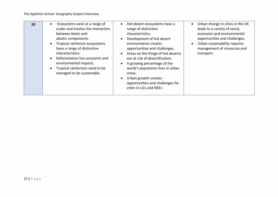
10 • Ecosystems exist at a range of scales and involve the interaction between biotic and abiotic components.
• Tropical rainforest ecosystems have a range of distinctive characteristics.
• Deforestation has economic and environmental impacts.
• Tropical rainforests need to be managed to be sustainable.
• Hot desert ecosystems have a range of distinctive characteristics.
• Development of hot desert environments creates opportunities and challenges.
• Areas on the fringe of hot deserts are at risk of desertification.
• A growing percentage of the world’s population lives in urban areas.
• Urban growth creates opportunities and challenges for cities in LICs and NEEs.
• Urban change in cities in the UK leads to a variety of social, economic and environmental opportunities and challenges.
• Urban sustainability requires management of resources and transport.

The Appleton School. Geography Subject Overview.
38 | P a g e
11 • analyse the inter-relationship between physical and human factors on maps and establish associations between observed patterns on thematic maps.
• There are global variations in economic development and quality of life.
• Various strategies exist for reducing the global development gap.
• Some LICs and NEEs are experiencing rapid economic development which leads to significant social, environmental and cultural change.
• Major changes in the economy of the UK have affected, and will continue to affect, employment patterns and regional growth.
• Food, water and energy are fundamental to human development.
• The changing demand and provision of resources in the UK create opportunities and challenges.
• Demand for energy resources is rising globally but supply can be insecure, which may lead to conflict.
• Different strategies can be used to increase energy supply.

The Appleton School. Geography Subject Overview.
39 | P a g e
12 • Global distribution and size of major stores of water
• Processes driving change in the magnitude of these stores over time and space
• Drainage basins as open systems
• Runoff variation and the flood hydrograph.
• Changes in the water cycle over time to include natural variation
• Global distribution, and size of major stores of carbon
• Processes driving change in the magnitude of these stores over time and space
• Changes in the carbon cycle over time, to include natural variation
• The carbon budget and the impact of the carbon cycle upon land, ocean and atmosphere, including global climate.
• The key role of the carbon and water stores and cycles in supporting life on Earth with particular reference to climate
• Human interventions in the carbon cycle designed to influence carbon transfers and mitigate the impacts of climate change.
• Sources of energy in coastal environments:
• Sediment sources, cells and budgets.
• Geomorphological processes:
• Distinctively coastal processes:
• Origin and development of landforms and landscapes of coastal erosion
• Origin and development of landforms and landscapes of coastal deposition
• Estuarine mudflat/saltmarsh environments and associated landscapes
• Coastlines of emergence and submergence.
• Eustatic, isostatic and tectonic sea level change
• Coastlines of emergence and submergence
• Recent and predicted climatic change and potential impact on coasts.
• The relationship between process, time, landforms and landscapes in coastal settings Coasts as natural systems
• Systems and processes
• Coastal landscape development
• Coastal management
• Case study(ies) of coastal environment(s) at a local scale to illustrate and analyse fundamental coastal processes
• Case study of a contrasting coastal landscape beyond the UK to illustrate and analyse how it presents risks and opportunities for human occupation and development and evaluate human responses of resilience, mitigation and adaptation.
• The concept of hazard in a geographical context
• Earth structure and internal energy sources
• Destructive, constructive and conservative plate margins. Characteristic processes:
• Magma plumes and their relationship to plate movement.
• The nature of vulcanicity and its relation to plate tectonics:
• Impacts and risk management
• Impacts and human responses as evidenced by a recent volcanic event.
• The nature of seismicity and its relation to plate tectonics
• Impacts and risk management
• Impacts and human responses as evidenced by a recent event.
• The nature of tropical storms and their underlying causes. Forms of storm hazard:
• Impacts and hazard management
• Impacts and human responses as evidenced by two recent tropical storms in contrasting areas of the world.
• Nature of wildfires
• Impact and human responses as evidenced by a recent wild fire event.
• Case study of a multi-hazardous environment beyond the UK
• Case study at a local scale of a specified place in a hazardous setting

The Appleton School. Geography Subject Overview.
40 | P a g e
13 • Dimensions of globalisation
• Factors in globalisation
• Form and nature of economic, political, social and environmental interdependence in the contemporary world.
• Issues associated with interdependence • Global features and trends in the volume
and pattern of international trade and investment associated with globalisation.
• Trading relationships and patterns
• Differential access to markets
• The nature and role of transnational corporations (TNCs)
• World trade in at least one food commodity or one manufacturing product
• Analysis and assessment of the geographical consequences of global systems
• The emergence and developing role of norms, laws and institutions
• Issues associated with attempts at global governance
• The concept of the ‘global commons’.
• An outline of the contemporary geography, including climate, of Antarctica
• Critical appraisal of the developing governance of Antarctica
• The role of NGOs in monitoring threats and enhancing protection of Antarctica.
• Analysis and assessment of the geographical consequences of global governance
• Globalisation critique
• Global and regional patterns of food production and consumption.
• Characteristics and distribution of two major climatic types to exemplify relationships between climate and human activities and numbers
• Characteristics and distribution of two key zonal soils
• Strategies to ensure food security.
• Global patterns of health, mortality and morbidity
• The relationship between environment variables e.g. climate, topography (drainage) and incidence of disease.
• The global prevalence, distribution, seasonal incidence of one specified biologically transmitted disease
• The global prevalence and distribution of one specified non-communicable disease
• Role of international agencies and NGOs in promoting health and combating disease at the global scale
• Factors in natural population change
• International migration:
• Population growth dynamics
• Population, resources and pollution model:
• Health impacts of global environmental change:
• Prospects for the global population
• Case study of a country/society experiencing specific patterns of overall population change – increase or decline
• Case study of a specified local area to illustrate and analyse the relationship between place and health
• The concept of place and the importance of place in human life and experience
• Insider and outsider perspectives on place. Categories of place:
• Factors contributing to the character of places:
• Changing places – relationships, connections, meaning and representation
• The impact of relationships and connections on people and place with a particular focus on: changing demographic and cultural characteristics
• The importance of the meanings and representations attached to places by people with a particular focus on people's lived experience of place in the past and at present.
• Local place study exploring the developing character of a place local to the home or study centre.
• Contrasting place study exploring the developing character of a contrasting and distant place.
The Appleton School. Geography Subject Overview.
41 | P a g e
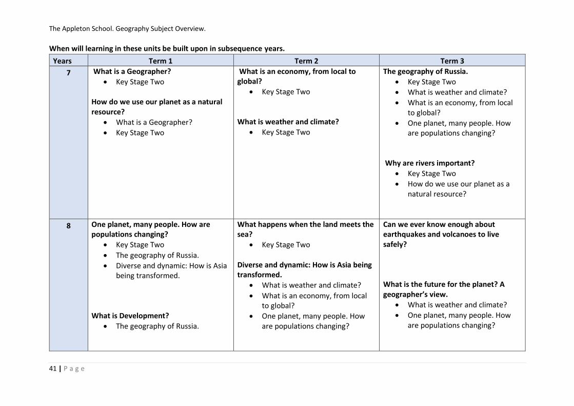
When will learning in these units be built upon in subsequence years.
Years Term 1 Term 2 Term 3
7 What is a Geographer?
• Key Stage Two How do we use our planet as a natural resource?
• What is a Geographer?
• Key Stage Two
What is an economy, from local to global?
• Key Stage Two What is weather and climate?
• Key Stage Two
The geography of Russia.
• Key Stage Two
• What is weather and climate?
• What is an economy, from local to global?
• One planet, many people. How are populations changing?
Why are rivers important?
• Key Stage Two
• How do we use our planet as a natural resource?
8 One planet, many people. How are populations changing?
• Key Stage Two
• The geography of Russia.
• Diverse and dynamic: How is Asia being transformed.
What is Development?
• The geography of Russia.
What happens when the land meets the sea?
• Key Stage Two Diverse and dynamic: How is Asia being transformed.
• What is weather and climate?
• What is an economy, from local to global?
• One planet, many people. How are populations changing?
Can we ever know enough about earthquakes and volcanoes to live safely? What is the future for the planet? A geographer’s view.
• What is weather and climate?
• One planet, many people. How are populations changing?

The Appleton School. Geography Subject Overview.
42 | P a g e
9 Africa
• What is development Ice.
• Climate change Natural Hazards
• What is weather and climate?
• Why are rivers important?
• Can we ever know enough about earthquakes and volcanoes to live safely?
• What is Development?
Weather in the UK
• What is weather and climate? Extreme Weather
• What is weather and climate? Climate Change
• What is weather and climate?
• What is the future for the planet? A geographer’s view.
River Landscapes
• Why are rivers important? Physical Fieldwork
• River Landscapes
• Why are rivers important?
• Coastal Landscapes in the UK
• What happens when the land meets the sea?
DME – Paper 3

The Appleton School. Geography Subject Overview.
43 | P a g e
10 Ecosystems
• How do we use our planet as a natural resource?
• Weather in the UK
• What is weather and climate? Tropical Rainforests
• How do we use our planet as a natural resource?
• What is Development? Hot Deserts
• How do we use our planet as a natural resource?
• What is Development?
Coastal Landscapes in the UK
• What happens when the land meets the sea?
Urban Issues and challenges
• What is Development?
• One planet, many people. How are populations changing?
• Extreme Weather
• Natural Hazards
• Tropical Rainforests
• Ecosystems
Changing Economic World.
• How do we use our planet as a natural resource?
• What is Development?
• What is an economy, from local to global?
Human Geography Fieldwork.
• Urban Issues and challenges
• One planet, many people. How are populations changing?
• What is an economy, from local to global?
The Appleton School. Geography Subject Overview.
44 | P a g e
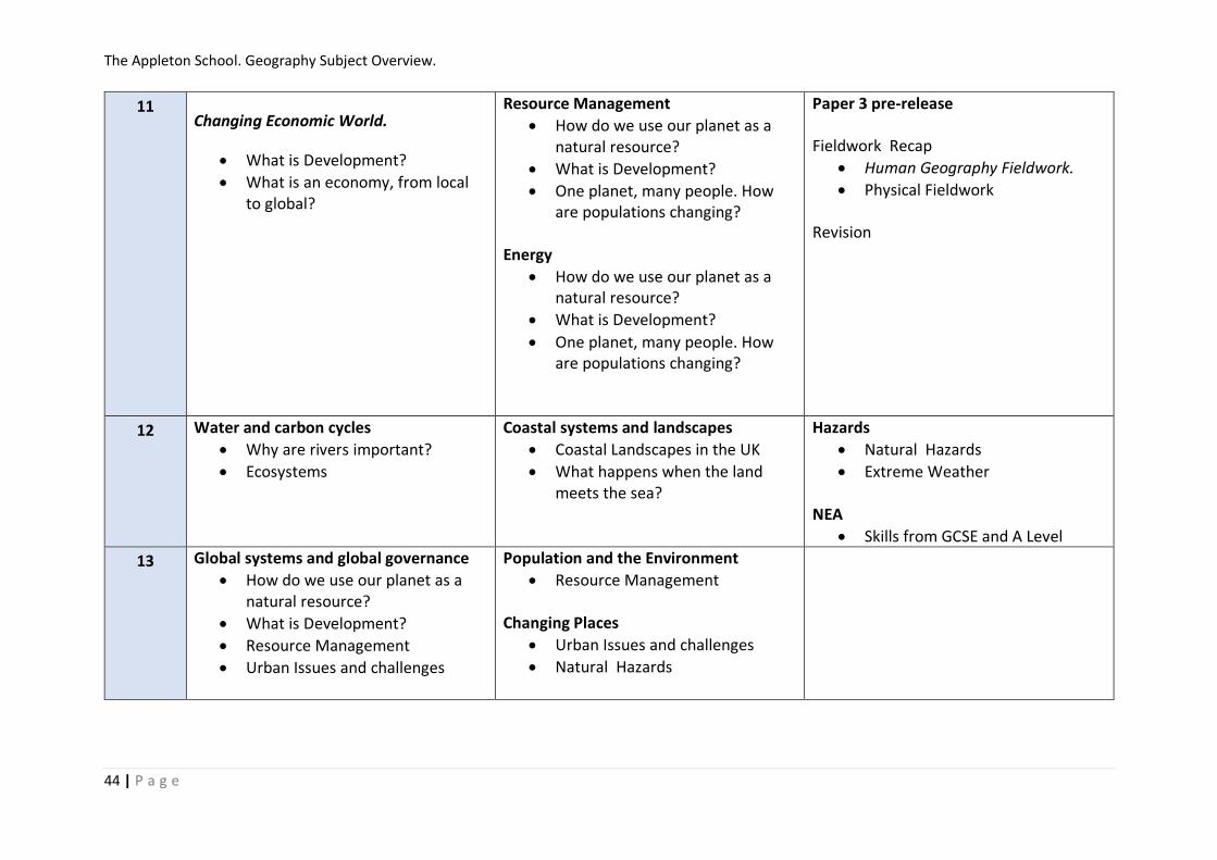
11 Changing Economic World.
• What is Development?
• What is an economy, from local to global?
Resource Management
• How do we use our planet as a natural resource?
• What is Development?
• One planet, many people. How are populations changing?
Energy
• How do we use our planet as a natural resource?
• What is Development?
• One planet, many people. How are populations changing?
Paper 3 pre-release Fieldwork Recap
• Human Geography Fieldwork.
• Physical Fieldwork Revision
12 Water and carbon cycles
• Why are rivers important?
• Ecosystems
Coastal systems and landscapes
• Coastal Landscapes in the UK
• What happens when the land meets the sea?
Hazards
• Natural Hazards
• Extreme Weather NEA
• Skills from GCSE and A Level
13 Global systems and global governance
• How do we use our planet as a natural resource?
• What is Development?
• Resource Management
• Urban Issues and challenges
Population and the Environment
• Resource Management Changing Places
• Urban Issues and challenges
• Natural Hazards