geogrid reinforced granular pad foundation resting … · geogrid reinforced granular pad...
TRANSCRIPT

CASE STUDY
Geogrid Reinforced Granular Pad Foundation Resting on Looseand Soft Soils, Hamilton Harbour, Ontario
C. Alston1 • D. K. Lowry2 • A. Lister3
Received: 21 April 2015 / Accepted: 1 June 2015 / Published online: 7 July 2015
� Springer International Publishing AG 2015
Abstract The waterfront quays in Hamilton Harbour
have been constructed by placing upfill within a perimeter
steel sheet pile bulkhead. The fill materials are believed to
consist of dredged material loosely placed on the original
harbour bed, within the enclosure. The quayside had been
used for general dock activities, including stockpiling
discharged ships’ cargoes. Recently, two 31 m diameter
liquid storage tanks have been constructed on the site; the
stored liquid applies a load of 120 kPa to the ground sur-
face. Based on borehole data developed in an initial
geotechnical investigation of the site, it was recommended
that the tank loadings be supported on either stone columns
or end bearing pile foundations. The cost of these foun-
dation systems was prohibitive to the development. Addi-
tional fieldwork consisting of three soundings with a
Marchetti flat plate dilatometer was carried out to better
define the geotechnical properties of the soil profile. Using
these data, a foundation design was prepared which con-
sisted of construction of a geogrid reinforced granular pad.
Post construction monitoring of settlement of the tank
foundation shows that settlement of the foundation has
been within tolerable limits.
Keywords Soft soils � In situ testing by flat dilatometer �Settlement � Foundation design with geogrid reinforcement
Introduction
The site development consisted of the design and con-
struction of two 31 m diameter liquid storage tanks at the
Emerald Street Slip, which lies on the south side of
Hamilton Harbour, Ontario, Canada (Fig. 1). At this loca-
tion the land has been reclaimed from the Harbour by
construction of a steel sheet pile bulkhead enclosure which
was then infilled on the landward side to provide a level
surface for cargo handling and storage. It is believed that
the infill used to raise the grade in the slip area consisted of
harbour bed dredged material, which was loosely placed on
the harbour bed within the perimeter bulkhead.
In the vicinity of the development site, various buildings
and storage tanks have been constructed. However, the
study site is situated on a previously undeveloped area of
the Slip. Anecdotal evidence indicates that some of the
current development site had been used previously for
storage of unloaded ships cargoes consisting of construc-
tion aggregates in conical piles, which were more than
10 m high. The perimeter of such storage stockpiles was
believed to lie between the north and south limits of the
development site, which resulted in the soil profile beneath
the southerly portion of the site area having experienced
consolidation under such applied loads.
A previous geotechnical investigation of the site area
was undertaken prior to undertaking the described inves-
tigation and design works. That study consisted of
advancing six conventional sampled boreholes to depths of
up to 26 m. Sampling and in situ testing was carried out in
those boreholes by the standard penetration test method.
The results of that test program illustrated the following
typical soil profile:
• Ground surface to 0.5 m; pavement structure.
& C. Alston
1 Alston Geotechnical Consultants Inc., 102 Senator Reesor’s
Drive, Markham, ON L3P 3E5, Canada
2 Armtec, 370 Speedvale Avenue West, Guelph N1H 7M7,
Canada
3 TenCate Mirafi, 2113 Keith Close, Burlington,
ON L7M 3H8, Canada
123
Int. J. of Geosynth. and Ground Eng. (2015) 1:21
DOI 10.1007/s40891-015-0022-6

• 0.5 to 7–12 m; Fill, mostly consisting of silt to sand
with zones of silty clay. The layer is considered in two
sections, with an approximate 2 m thick upper sub-unit
of loose to compact sand and gravel with some ash
lying on very loose to loose silt to silty sand. The soil
condition was interpreted from standard penetration test
N values of 8–55 blows/300 mm recorded in the upper
sub-unit of the fill, and N values of 1–5 blows/300 mm
in the lower portion of the layer.
• 7–12 to 24 m; soft to firm becoming stiff silty clay, soil
consistency represented by N values of 1–34 blows/
300 mm, more commonly in the range of 3–15 blows/
300 mm;
• 24–26 m, dense to very dense clayey silt and sand,
condition represented by an N value of more than 50
blows/300 mm;
• 26 m shale bedrock.
In one of the boreholes, a 4 m thick layer of compressed
peat was found to be sandwiched between the base of the fill
and the underlying sequence of mineral soil deposits;
N values of 7 and 8 blows/300 mm were measured in this
Fig. 1 Site plan, Emerald
Street Slip Hamilton Harbour
Fig. 2 Exploration location
plan
21 Page 2 of 11 Int. J. of Geosynth. and Ground Eng. (2015) 1:21
123

soil lens. A plan showing the locations of geotechnical
explorations is given in Fig. 2. A copy of a log sheet for a
representative borehole is given in Fig. 3. On the basis of the
determined soil profile and interpreted soil condition data
from the sampled borehole investigation, the original
geotechnical engineer concluded that the soil profile
underlying the site could not support the tank loads and that
each of the two storage tanks should be founded on an array
of end bearing piles which would be embedded in the very
dense basal soil stratum or on bedrock. An alternative rec-
ommendation was given that the condition of the underlying
soils could be improved sufficiently to support the tanks by
installation of a set of stone columns. The estimated cost
of providing such a foundation was approximately
$500,000.00, above the cost of a conventional shallow
foundation, which compromised the financial viability of the
project. Therefore, the owner determined that an indepen-
dent review of the subsurface data be carried out with a view
to developing a design which provides foundation support at
shallow depth in the soil profile.
Some details of this case study were previously pre-
sented by Alston et al. [1].
Geotechnical Investigation of In Situ Soil Properties
It is well known that steel storage tanks are settlement
tolerant [2–4]. Also, as noted in Sect. 1, anecdotal evidence
indicated that previously, the southerly portion of the site
had been loaded with stockpiles of aggregate materials to a
height of up to about 10 m. Thus, past performance of the
ground in the general area of the site had shown that the
subsurface profile was able to sustain significant surface
Fig. 3 Borehole log
Int. J. of Geosynth. and Ground Eng. (2015) 1:21 Page 3 of 11 21
123

loadings without experiencing a catastrophic shear failure.
On this basis, an additional geotechnical investigation of
the site [5] was undertaken to better define the in situ
properties of the soil profile. The second phase of
geotechnical work was designed to complement the avail-
able borehole data with a more sophisticated program of
in situ testing. This work unit consisted of advancing three
soundings using a Marchetti flat plate dilatometer (DMT)
to provide interpreted measures of in situ soil properties
[6]. A picture of a dilatometer blade is shown in Fig. 4 [7]
and a diagrammatic illustration of the test arrangement is
shown in Fig. 5 [7]. The soundings were advanced under
the northerly part of the development site in which the
anecdotal evidence indicated that no previous significant
loading had been applied to the site area, as well as in the
more central and southern portions of the site which are
believed to have been previously subject to significant
loading by aggregate stockpiles. The results of the north-
erly sounding (DMT 102) and the southerly sounding
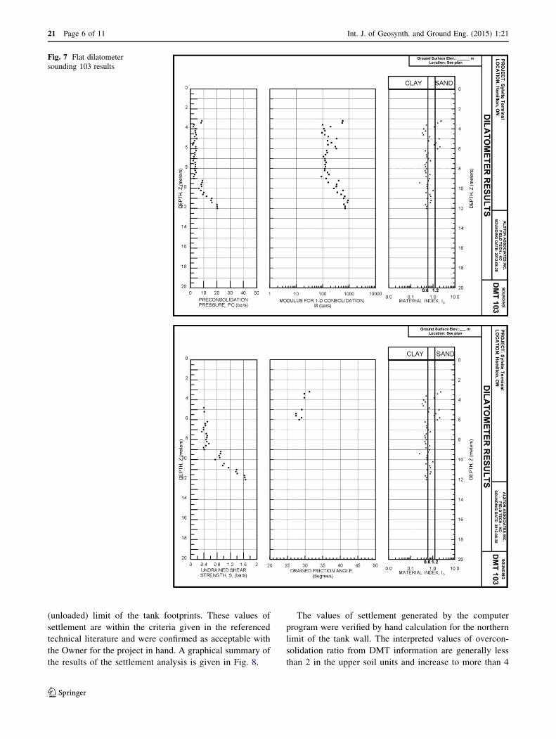
(DMT 103) are given in Figs. 6 and 7, respectively. Ref-
erence to the results of the soundings illustrates the inter-
preted behavioural character of the overlying fill materials
as well as the inferred engineering properties of the various
soil materials which were contacted in the soundings.
Reference to the reported in situ test results also illustrates
the beneficial effect of previous loading of the site by
stockpiled aggregates on soil parameters such as undrained
shear strength and constrained modulus. Summaries of the
soil parameters selected for stability analysis and settle-
ment predictions are shown in Table 1.
Published literature [8, 9] shows that good confidence
can be placed on the results of DMT soundings with regard
to settlement predictions.
Geotechnical Design
The results of the subsurface investigations of the site showed
that the geotechnical design of surface supported structures
would be primarily controlled by the properties of the rela-
tivelyweak surficial layer of fill and the upper soft to firm zone
of the underlying silty clay soil deposit. These soil layers could
be expected to experience significant consolidation as a result
of load application. The shear strength characteristics of the
respective soil layers limit the intensity of foundation load
which can be applied to these layers to a modest level, unless
the soil materials were to be improved or mechanical appur-
tenances designed to increase tensile strengthwere included in
foundation design.
In order to assess the feasibility of adopting a design
based on a tank base resting on grade and shallow foun-
dations to support the tank wall loads, an estimate of
Fig. 4 Illustration of test blade Marchetti flat plate dilatometer
Fig. 5 Illustration of field arrangement Marchetti flat plate
dilatometer
21 Page 4 of 11 Int. J. of Geosynth. and Ground Eng. (2015) 1:21
123

probable settlement was made to determine if this could
meet the project’s operational criteria. Analysis was carried
out using the GEO5 program ‘‘Settlement’’, verified by
hand calculations. The analysis of the probable consoli-
dation settlement of loaded tank foundations was carried
out using the values of constrained (deformation) modulus
of the soil materials which were interpreted from the DMT
results. The analysis gave estimated settlements of about
55 mm at the south (probably preloaded) limit of the tanks,
130 mm at the tank centre and about 80 mm at the northern
Fig. 6 Flat dilatometer
sounding 102 results
Int. J. of Geosynth. and Ground Eng. (2015) 1:21 Page 5 of 11 21
123
(unloaded) limit of the tank footprints. These values of
settlement are within the criteria given in the referenced
technical literature and were confirmed as acceptable with
the Owner for the project in hand. A graphical summary of
the results of the settlement analysis is given in Fig. 8.
The values of settlement generated by the computer
program were verified by hand calculation for the northern
limit of the tank wall. The interpreted values of overcon-
solidation ratio from DMT information are generally less
than 2 in the upper soil units and increase to more than 4
Fig. 7 Flat dilatometer
sounding 103 results
21 Page 6 of 11 Int. J. of Geosynth. and Ground Eng. (2015) 1:21
123

below a depth of 8.5 m; on that basis it was expected that
little consolidation would occur below that depth. The
estimated settlement at the check position was as shown in
Table 2.
This gives an accumulated consolidation settlement of
72 mm, which is comparable with, but less conservative
than, the computed value of 80 mm.
The settlement criteria being met, the design challenge
was to include tensile reinforcement in the design which
would upgrade the support characteristics of the underlying
relatively weak soils to secure the foundations against
shear failure in the foundation soils with adequate factors
of safety, to meet contemporary standards.
The borehole and sounding data show that the near
surface fill materials underlying the site consist of a variety
of dominantly granular material (sand, gravel, ash, cinders
present in varying proportions). The results of grain size
distribution tests carried out on samples of the upper sub-
unit of the fill show that these materials could be selec-
tively excavated and mostly re-used and engineered to
provide a granular pad with consistent soil properties to
support tank foundations, provided that the pad is suitably
reinforced. Analysis showed that inclusion of geosynthetic
reinforcement in the engineered granular fill pad would add
sufficient tensile strength to the fill pad to improve the
design factors of safety with respect to both local and
global stability, to satisfy conventional foundation design
criteria. The selected reinforcement consisted of including
two layers of polyester geogrid each with an ultimate
tensile strength of 68 kN/m in the primary direction (Mirafi
5XT) in the engineered fill pad; the main direction of the
selected uniaxial geogrid was to be laid radially towards
the centre of the tank, and perpendicular to the tank wall.
The lower level of geogrid was positioned at the base of the
fill pad and the second layer 300 mm above the base. The
design thickness of the engineered granular base is 1.5 m.
The adopted analytical method to assess global stability
was based on the assumption that a beneficial horizontal
reinforcement force can be included in a simplified Bishop
analysis [10–12]. A summary of the results of the global
stability analyses which show that the critical failure sur-
face, with respect to global stability, is given in Fig. 9. This
figure also illustrates the differences in the properties of the
soil profile between the south and north sides of the tanks.
The factor of safety of the critical failure surface with
respect to global stability for the selected foundation design
was determined to be 1.54.
The beneficial effect of the geogrid reinforcement on
increasing the bearing capacity of the granular pad with
regard to the perimeter wall foundations was evaluated
using methodology given by FHWA [13]. This was ade-
quate to meet design criteria.
Construction of the Foundation
Construction of the foundation consisted of removing the
existing site surface layer of asphaltic concrete pavement
as well as the immediately underlying zones of the upper
fill layer to a depth of 1.5 m below the base of the tank
foundation. The excavation phase was followed by dense
compaction of the material exposed in the base of the
excavation to its maximum practical density, which was
carried out using a smooth drum roller with a static load of
10 tonnes under full time engineering control. Satisfactory
compaction of the base was assured by visual engineering
inspection and in situ testing with a hand operated static
penetrometer. The base layer of geogrid reinforcement was
laid in a radial pattern on the floor of the excavation
beneath the footprint of the tanks and extending outside the
footprint of the wall footing for a width of 3 m. A plan of
the layout of the geogrid sheets is given in Fig. 10, and an
image of the emplaced geogrid is given in Fig. 11. A
300 mm thick layer of the local, excavated granular fill
adjudged suitable by the Engineer’s on-site representative
was laid on the base geogrid and compacted to 100 % of
the material’s standard Proctor maximum dry density. The
second layer of the geogrid was laid on the emplaced lift of
compacted fill to the same pattern and dimensions as the
lower sheets of reinforcement. Above the reinforcement,
the grade was raised to the design elevations using local
suitable granular fill which was compacted to 100 % of
material’s standard Proctor maximum dry density.
Construction of the reinforced concrete tank wall
foundations and tank base proceeded on top of the geogrid
reinforced, densely compacted pad of engineered fill.
Table 1 Geotechnical properties of soil units
Soil unit Approximate
depth range
(south) (m)
Approximate
depth range
(north) (m)
Angle of
internal
friction (�)
Undrained shear
strength (south)
(kPa)
Undrained shear
strength (north)
(kPa)
Constrained
modulus
(south) (MPa)
Constrained
modulus
(north) (MPa)
Silty clay fill – 0–4 – – 20 – 4.5
Silt and sand fill 0–9 4–5.5 27 – – 20 20
Firm silty clay – 5.5–10 – – 28 – 10
Stiff silty clay 9? 10? – 70 70 10 10
Int. J. of Geosynth. and Ground Eng. (2015) 1:21 Page 7 of 11 21
123

Performance
Reference to the results of the settlement analysis indicates
that the predicted consolidation settlement of the support-
ing soil profile at the southern limit of the tank wall
foundation was approximately 55 mm, and about 85 mm at
the northern limit. The difference between the two esti-
mated settlement values is attributed to the result of the
effects of previous loading of the site by aggregate stock-
piles. Actual settlement values were measured on the
Fig. 8 Results of settlement
analysis
Table 2 Estimated settlement
in design calculationsDepth range Average increase
in vertical stress (kPa)
Constrained
modulus (MPa)
Consolidation
settlement (mm)
0–4 60 4.5 53
4–5.5 55 20.0 4
5.5–8.5 50 10.0 15
21 Page 8 of 11 Int. J. of Geosynth. and Ground Eng. (2015) 1:21
123

foundation wall of one of the tanks and those results are
given in Table 3.
The measured values show settlements of about 70 and
80 % of the theoretical predictions for the north and south
sides of the tank, respectively. The underlying soils consist
of loose (fill) or soft to firm (silty clay) materials and some
ongoing creep settlement is expected. The actual settlement
of the wall foundations falls within a reasonable proximity
of the predicted values.
The cost premium of the adopted reinforced soil pad
foundation system constructed on the site compared with a
conventional footing foundation under the tank walls and a
granular base beneath the tank floor was about $200,000.00
for the two tank foundations. The estimated cost premium of
a foundation comprising either a system of end bearing piles
or stone columns was more than $500,000.00 above the cost
of a footing foundation. Thus, the selection of the reinforced
pad foundation resulted in a cost saving of about 60 %
compared to the initially recommended foundation system.
An image of the completed tanks are given in Fig. 12.
Fig. 9 Global stability analysis
Fig. 10 Plan view of geogrid layout
Int. J. of Geosynth. and Ground Eng. (2015) 1:21 Page 9 of 11 21
123

Conclusions
(1) Characterization of strength and deformation
parameters of the supporting soil strata by an
in situ test method (Marchetti flat dilatometer) has
resulted in good characterization of the soil
properties.
(2) Construction of an engineered pad of reinforced
granular fill above layers of relatively weak, com-
pressible fill and native soils resulted in the foundation
experiencing only moderate differential settlement,
which is well within tolerable limits.
(3) Design carried out using conventional limit equilib-
rium methods which account for the beneficial effect
Table 3 Settlement of
perimeter ring beam foundationTime from first load application Predicted settlement Measured settlement
North side
(mm)
South side
(mm)
North side
(mm)
South side
(mm)
1 week – – 9 9
1 month – – 25 23
1 year 80 50 54 41
Fig. 11 Geogrid reinforcement on excavation base
Fig. 12 Completed tanks
21 Page 10 of 11 Int. J. of Geosynth. and Ground Eng. (2015) 1:21
123
of geosynthetic reinforcement, and using conven-
tional one dimensional consolidation theory are
shown to adequately describe the site and result in
a foundation performance which is satisfactory in
service.
(4) The adoption of a foundation design utilizing the
tensile strength of geogrid reinforcement enabled a
cost savings of about $300,000.00 on a previously
estimated cost premium of about $500,000.00 for a
foundation supported by either end bearing piles or
stone columns.
Acknowledgments The authors wish to thank the facility owner,
Sylvite, and their General Contractor, Barclay Construction who
supported the development of a non-traditional approach to founda-
tion design and construction for the project. Barclay Construction
particularly assisted and cooperated with the design team in all
aspects of making this project successful.
References
1. Alston C., Lowry D.K., Lister A. (2015) Design and performance
of geogrid reinforced foundation for storage tanks resting on
loose, thick fill, Hamilton Harbour, Ontario. In: IFAI geosyn-
thetics conference, Portland, Oregon
2. US Army Corps of Engineers (1999) Engineering and design,
settlement analysis, Table 2–3, Engineering Manual 1110-1-1904
3. Rosenberg P, Journeaux NL (1992) Settlement limitations for
cylindrical steel storage tanks. Can Geotech J 19:232–238
4. Akhaven AA (2009) Settlement criteria for steel oil storage tanks.
EJGE 13:1–9
5. Alston Associates Inc. (2012) Geotechnical investigation study,
proposed tank developments. Sylvite Group of Companies,
Emerald Street Slip, Hamilton
6. Marchetti S (1980) In situ tests by flat dilatometer. J ASCE
106(GT3):299–321
7. Marchetti S (2015) Personal communication, illustrations of Flat
Plate Dilatometer
8. Technical Committee TC16 (2001) The DMT in soil investiga-
tions. A report by ISSMGE TC16
9. Mondaco P, Totani G, Celebrese M (2006) DMT—predicted
versus observed settlements: a review of the available experience.
In: Proceedings on 2nd international conference on the flat
dilatometer, Washington, pp. 244–252
10. Holtz RD (1990) Design and construction of geosynthetically
reinforced embankments on very soft soils. State of the art report,
performance of reinforced soil structures. British Geotechnical
Society, p. 391–402
11. Holtz RD, Christopher BR, Berg RR (1998) Geosynthetic design
and construction guidelines, FHWA HI-95-038
12. Jones CJFP (1996) Earth reinforcement and soil structures.
Thomas Telford, London
13. Abu-Farsakh, MY and Chen Q (2008) Use of reinforced soil
foundations (RSF) to support shallow foundation. Report No.
FHWA/LA. 08/424, Louisiana Transportation Research Centre,
Baton Rouge, LA, USA
Int. J. of Geosynth. and Ground Eng. (2015) 1:21 Page 11 of 11 21
123