geohydrological assessment and groundwater flow modelling
TRANSCRIPT

Technical Report: 2010-04-05 GHYD
Document version 5.1 – Final
Geohydrological Assessment and Groundwater Flow Modelling for Potential Groundwater Use at the
Proposed Development At and Adjacent to Klein Kariba, Bela Bela, LIMPOPO
Prepared for: AJK Projects
February 2011
Compiled by:
R Crosby

Directors (Executive Committee): SJ Pretorius, JA Myburgh, JJP Vivier, THG Ngoepe, JH Botha, H Pretorius, SM Haasbroek
(Board Members): R Crosby, FN de Jager, AS Potgieter, CJH Potgieter, CJ Vivier
Technical report: 2010-04-05 GHYD
Geohydrological Assessment and Groundwater Flow Modelling for Potential Groundwater Use at the
Proposed Development At and Adjacent to Klein Kariba, Bela Bela, LIMPOPO
07 February 2011
Conducted on behalf of:
Compiled by:
R Crosby
Project team:
R Crosby (BSc. Honours Geohydrology) Pr. Sci. Nat
LIMPOPO PROVINCE: 120 Marshall Street, POLOKWANE
P. O. Box 2526, PIETERSBERG, 0700
Tel: +27-15-291 1577 Fax: +27-15-291 1577
www.ages-group.com

AGES -i-
REPORT DISTRIBUTION LIST
Name Institution
AJ Kruger AJK Projects
W de Wet Klein Kariba Resort
E Grobler AGES Limpopo
DOCUMENT HISTORY
Report no Date Version Status
AS-R-2010-03-15 15 March 2010 1.0 Draft Model Report
2010-04-05 GHYD 19 April 2010 2.0 Draft
AS-R-2010-03-15 18 June 2010 3.0 Draft Model Report
AS-R-2010-03-15 5 July 2010 4.0 Final Model Report
2010-04-05-GHYD 6 July 2010 4.1 Final Report
2010-04-05-GHYD 22 November 2010 4.2 FINAL REPORT
2010-04-05-GHYD 07February 2011 5.1 FINAL REPORT
Amendments – v4.2 Updated Development Plan
V5.1 Concerns raised by Water Users at the Public Meeting – 22 November 2010

AGES -ii-
Although Africa Geo-Environmental Services (Pty) Ltd exercises due care and diligence in rendering services and preparing documents, Africa Geo-Environmental Services (Pty) Ltd accepts no liability,
and the client, by receiving this document, indemnifies Africa Geo-Environmental Services (Pty) Ltd and
its directors, managers, agents and employees against all actions, claims, demands, losses, liabilities,
costs, damages and expenses arising from or in connection with services rendered, directly or indirectly
by Africa Geo-Environmental Services (Pty) Ltd and by the use of the information contained in this
document.
This document contains confidential and proprietary information of Africa Geo-Environmental Services (Pty) Ltd and is protected by copyright in favour of Africa Geo-Environmental Services (Pty) Ltd and
may not be reproduced, or used without the written consent of Africa Geo-Environmental Services (Pty)
Ltd, which has been obtained beforehand. This document is prepared exclusively for AJK Projects and
is subject to all confidentiality, copyright and trade secrets, rules, intellectual property law and practices
of South Africa.

Klein Kariba Water Supply: Geohydrological Assessment, and Groundwater Flow Modelling
AGES -iii-
Notations and terms
Advection is the process by which solutes are transported by the bulk motion of the flowing
groundwater.
Anisotropic is an indication of some physical property varying with direction.
Cone of depression is a depression in the groundwater table or potentiometric surface that has the
shape of an inverted cone and develops around a borehole from which water is being withdrawn. It
defines the area of influence of a borehole.
A confined aquifer is a formation in which the groundwater is isolated from the atmosphere at the point
of discharge by impermeable geologic formations; confined groundwater is generally subject to
pressure greater than atmospheric.
The darcy flux, is the flow rate per unit area (m/d) in the aquifer and is controlled by the hydraulic
conductivity and the piezometric gradient.
Dispersion is the measure of spreading and mixing of chemical constituents in groundwater caused by
diffusion and mixing due to microscopic variations in velocities within and between pores.
Drawdown is the distance between the static water level and the surface of the cone of depression.
Effective porosity is the percentage of the bulk volume of a rock or soil that is occupied by interstices
that are connected.
Groundwater table is the surface between the zone of saturation and the zone of aeration; the surface
of an unconfined aquifer.
A fault is a fracture or a zone of fractures along which there has been displacement.
Hydrodynamic dispersion comprises of processes namely mechanical dispersion and molecular
diffusion.
Hydraulic conductivity (K) is the volume of water that will move through a porous medium in unit time
under a unit hydraulic gradient through a unit area measured perpendicular to the area [L/T]. Hydraulic
conductivity is a function of the permeability and the fluid’s density and viscosity.
Hydraulic gradient is the rate of change in the total head per unit distance of flow in a given direction.
Heterogeneous indicates non-uniformity in a structure.
Karstic topography is a type of topography that is formed on limestone, gypsum, and other rocks by
dissolution, and is characterised by sinkholes, caves and underground drainage.
Mechanical dispersion is the process whereby the initially close group of pollutants are spread in a
longitudinal as well as a transverse direction because of velocity distributions.
Molecular diffusion is the dispersion of a chemical caused by the kinetic activity of the ionic or molecular
constituents.
Observation borehole is a borehole drilled in a selected location for the purpose of observing
parameters such as water levels.
Permeability is related to hydraulic conductivity, but is independent of the fluid density and viscosity and
has the dimensions L2. Hydraulic conductivity is therefore used in all the calculations.
Klein Kariba Water Supply: Geohydrological Assessment, and Groundwater Flow Modelling
AGES -iv-
Piezometric head (φ) is the sum of the elevation and pressure head. An unconfined aquifer has a water
table and a confined aquifer has a piezometric surface, which represents a pressure head. The
piezometric head is also referred to as the hydraulic head.
Porosity is the percentage of the bulk volume of a rock or soil that is occupied by interstices, whether
isolated or connected.
Pumping tests are conducted to determine aquifer or borehole characteristics.
Recharge is the addition of water to the zone of saturation; also, the amount of water added.
Sandstone is a sedimentary rock composed of abundant rounded or angular fragments of sand set in a
fine-grained matrix (silt or clay) and more or less firmly united by a cementing material.
Shale is a fine-grained sedimentary rock formed by the consolidation of clay, silt or mud. It is
characterised by finely laminated structure and is sufficiently indurated so that it will not fall apart on
wetting.
Specific storage (S0), of a saturated confined aquifer is the volume of water that a unit volume of aquifer
releases from storage under a unit decline in hydraulic head. In the case of an unconfined (phreatic,
watertable) aquifer, specific yield is the water that is released or drained from storage per unit decline in
the watertable.
Static water level is the level of water in a borehole that is not being affected by withdrawal of
groundwater.
Storativity is the two-dimensional form of the specific storage and is defined as the specific storage
multiplied by the saturated aquifer thickness.
Total dissolved solids (TDS) is a term that expresses the quantity of dissolved material in a sample of
water.
Transmissivity (T) is the two-dimensional form of hydraulic conductivity and is defined as the hydraulic
conductivity multiplied by the saturated thickness.
An unconfined, watertable or phreatic aquifer are different terms used for the same aquifer type, which
is bounded from below by an impermeable layer. The upper boundary is the watertable, which is in
contact with the atmosphere so that the system is open.
Vadose zone is the zone containing water under pressure less than that of the atmosphere, including
soil water, intermediate vadose water, and capillary water. This zone is limited above by the land
surface and below by the surface of the zone of saturation, that is, the water table.
Water table is the surface between the vadose zone and the groundwater, that surface of a body of
unconfined groundwater at which the pressure is equal to that of the atmosphere.

Klein Kariba Water Supply: Geohydrological Assessment, and Groundwater Flow Modelling
AGES -v-
LIST OF ABBREVIATIONS
Abbreviation Description
SWL Static Water Level
EC Electrical Conductivity
EIA Environmental Impact Assessment
TDS Total Dissolved Solids
m metre
km Kilometre
mg/ℓ milligram per litre
mS/m milli-Siemens per meter
m3/d Cubic meters per day

Klein Kariba Water Supply: Geohydrological Assessment, and Groundwater Flow Modelling
AGES -vi-
Table of Contents
1 INTRODUCTION .................................................................................................. 1
1.1 BACKGROUND............................................................................................................ 1
1.2 OBJECTIVES .............................................................................................................. 1
1.3 TERMS OF REFERENCE .............................................................................................. 1
1.4 SCOPE OF WORK ....................................................................................................... 1
1.5 STUDY AREA ............................................................................................................. 2
1.6 SOURCES OF INFORMATION ........................................................................................ 3
2 SITE DESCRIPTION ............................................................................................ 4
2.1 GEOGRAPHICAL SETTING ............................................................................................ 4
2.2 TOPOGRAPHICAL SETTING .......................................................................................... 4
2.3 GEOLOGICAL SETTING ................................................................................................ 4
2.4 GEOHYDROLOGICAL SETTING ..................................................................................... 5
2.5 CLIMATIC SETTING ..................................................................................................... 5
2.5.1 Rainfall ............................................................................................................................... 5
2.5.2 Evaporation ....................................................................................................................... 5
2.6 HYDRO CENSUS .................................................................................................... 6
2.6.1 Data review ........................................................................................................................ 6
2.6.2 Field visit ............................................................................................................................ 6
3 RESOURCE EVALUATION ............................................................................... 11
3.1 EXISTING INFORMATION ............................................................................................ 11
3.2 REGIONAL WATER QUALITY ...................................................................................... 12
4 REGIONAL GROUNDWATER POTENTIAL ..................................................... 13
4.1 GENERAL ................................................................................................................ 13
4.2 SCALE OF THE ABSTRACTION .................................................................................... 13
4.3 WATER DEMAND ...................................................................................................... 14
4.4 GROUNDWATER MODEL ........................................................................................... 14
4.5 MODEL SCENARIOS .................................................................................................. 15
4.6 HYDRAULIC PARAMETERS ........................................................................................ 16
4.7 MODELLING RESULTS ............................................................................................... 16
4.7.1 Scenario 1 ....................................................................................................................... 16
4.7.2 Scenario 2 ....................................................................................................................... 17
4.7.3 Scenario 3 ....................................................................................................................... 17
4.7.4 Scenario 4 ....................................................................................................................... 17
4.7.5 Scenario 5 ....................................................................................................................... 18
4.7.6 Scenario 6 ....................................................................................................................... 18

Klein Kariba Water Supply: Geohydrological Assessment, and Groundwater Flow Modelling
AGES -vii-
4.8 GROUNDWATER POTENTIAL ...................................................................................... 18
5 CONTAMINATION RISK ASSESSMENT .......................................................... 20
5.1 POSSIBLE SOURCES OF CONTAMINATION ................................................................... 20
5.2 RISK ASSESSMENT .................................................................................................. 20
6 CONCLUSIONS ................................................................................................. 21
7 RECOMMENDATIONS ...................................................................................... 24
7.1 GROUNDWATER DEVELOPMENT ................................................................................ 24
7.1.1 Existing Boreholes ........................................................................................................... 24
7.1.2 New Boreholes ................................................................................................................ 24
7.1.3 Return Waste Water ........................................................................................................ 25
7.2 WATER QUALITY ...................................................................................................... 25
7.3 ON SITE SANITATION ................................................................................................ 25
7.4 MONITORING AND MANAGEMENT .............................................................................. 25
8 REFERENCES ................................................................................................... 26

Klein Kariba Water Supply: Geohydrological Assessment, and Groundwater Flow Modelling
AGES -viii-
List of Figures
Figure 1: Summary of Borehole Census Results ............................................................................. 8
Figure 2: Regional Geological Setting .............................................................................................. 9
Figure 3: Rainfall Data for station 0589594 .................................................................................... 10
Figure 4: Groundwater Fingerprint ................................................................................................. 12
List of Tables
Table 1: Summary of the Proposed Development Area ..................................................................... 2
Table 2: Hydrocensus Summary ......................................................................................................... 7
Table 3: Borehole Utilisation Recommendations .............................................................................. 11
Table 4: Summary of the scale of Abstraction .................................................................................. 13
Table 5: Hydraulic zones in the calibrated model ............................................................................. 16

Klein Kariba Water Supply: Geohydrological Assessment, and Groundwater Flow Modelling
AGES -1-
1 INTRODUCTION
1.1 Background
AGES was appointed to compile a geohydrological assessment to support the
sustainable abstraction and use of groundwater for the proposed development on and
adjacent to the existing Klein Kariba Resort. An existing geohydrological assessment
compiled on portion of the proposed study area was available, but since both the extent
and the scope of the proposed development had been redefined, additional groundwater
is now required to support the proposed development.
1.2 Objectives
The objective of the geohydrological study is
• to determine the regional groundwater potential, and
• to evaluate the impact of groundwater abstraction by the proposed development on both the regional groundwater, and on neighbouring groundwater users and resources
1.3 Terms of Reference
AGES was appointed to conduct the geohydrological investigation and resource
evaluation, which includes a detailed numerical model to support the sustainable
utilisation of groundwater based on a cost proposal submitted on 3rd November 2009, and
accepted by Messrs AJK projects in correspondence received on 5th November 2009.
1.4 Scope of Work
The scope of work is summarised as the following:
• Evaluate the existing geo-hydrological study completed on portion of the property (Appendix A)
• Conduct a detailed hydro-census in a 2km radius around the development, and on neighbouring properties
• Develop a detailed numerical groundwater model to determine the groundwater potential for the area
o The scope of work for this phase includes groundwater flow modelling in Modflow Pro (software program), and is done by simulating the current geohydrological status around the area of investigation, which includes variable parameters such as aquifer Transmissivity, groundwater recharge and losses through abstraction and evapotranspiration.
o The planned groundwater abstraction for the proposed development is then included in the model and run as a separate scenario to determine the
Klein Kariba Water Supply: Geohydrological Assessment, and Groundwater Flow Modelling
AGES -2-
influence of the planned abstraction on both the regional aquifer, and on local water users.
o Results of the numerical model are presented as an attached report (appendix B), and motivate the sustainability of the groundwater abstraction.
• To make management recommendations regarding groundwater use, and the sustainable utilisation of the groundwater resource
• To compile a geohydrological report to support the water use license application
1.5 Study Area
In addition to the proposed development on portions 1, 2, 3, and 4 of the cadastral farm
Valentia 449-KR covering an area of approximately 1km2, current facilities and
infrastructure at the existing resort are to be upgraded. The total study area is thus
defined by the extent of the groundwater model boundary (see appendix B), and is
approximately 138km2 in extent.
Due to the relationship between the proposed development, and the Klein Kariba Resort,
the area of the resort (portion 87 of Buiskop 464-KR) of some 5.3km2 is included in the
investigation for the development of proposed boreholes. Table 1 presents a summary of
the areas included in the proposed development.
Table 1: Summary of the Proposed Development Area
The study area falls within the quaternary catchment A23G. Natural vegetation covers the majority of the study area, with the development of wildlife smallholdings along the northern boundary. To the south and west of the study area, a number of small scale agricultural activities are noted, with isolated incidence of irrigation.
Farm Portion Area (ha) Area (m2)
Valentia 449-KR 1 36.4648 364648
Valentia 449-KR 2 21.4133 214133
Valentia 449-KR 3 21.4133 214133
Valentia 449-KR 4 21.4133 214133
Buiskop 464-KR 87 528.6936 5286936
TOTAL 629.3983 6293983

Klein Kariba Water Supply: Geohydrological Assessment, and Groundwater Flow Modelling
AGES -3-
1.6 Sources of information
The following sources of information were used during the investigation:
Geohydrological map: 2326 PIETERSBURG; scale 1 : 500 000 Geological maps: 2428 NYLSTROOM, scale 1 : 250 000 Topocadastral map: 2428 CD; scale 1 : 50 000 Preliminary site map: Supplied in digital format by Messrs AJK Projects
Groundwater Harvest Potential of the Republic of South Africa Map
Alan Seymour and Paul Seward (1996), scale 1:3 000 000
Satellite Data Google Earth ™ satellite data
Digital Terrain Model (DTM) data obtained from GISCOE
Rainfall data South African Weather Services
Hydrocensus Information Information on groundwater verified during a hydrocensus
Geohydrological Report Kruidenier, JHB (2008) Geohydrological and Sanitation Risk
Assessment Study for the Proposed Resort on Portion 1 of
the Farm Valencia 449-KR. (G2007/149)
Groundwater Modelling Report Smit, JJ (2010) Klein Kariba Water Supply: Groundwater
Flow Modelling Report (AS-R-2010-03-15)
Klein Kariba Water Supply: Geohydrological Assessment, and Groundwater Flow Modelling
AGES -4-
2 SITE DESCRIPTION
2.1 Geographical setting
The area of investigation is located roughly five kilometres northeast of the town of Bela
Bela in the Limpopo Province. The approximate coordinates of the Klein Kariba Resort
are:
• Latitude: S -24.837663°
• Longitude: E 028.331313°
The area of the proposed new development is neighbouring on the northern boundary of
the existing holiday resort, and is topographically and hydraulically up-gradient from the
holiday resort. Any groundwater abstraction or pollution by the proposed development will
impact the groundwater use at the resort (Figure 1), (Unpublished AGES report AS-R-
2010-03-15 attached as appendix B).
2.2 Topographical setting
See the unpublished AGES report AS-R-2010-03-15 attached as appendix B.
The regional topography of the area is characterised by prominent outcrops of sandstone
to the north, and flat areas to the south (known as the Springbok Flats). Local topography
is characterised by the steep topographical changes created by the contact between the
quartzite outcrops to the north of the study area, and the valley flanking the southern
portions. The contact of the sandstone outcrops are incise by the drainage features from
the higher lying areas to the north, and forms valleys that fan out to the flat lying areas to
the south. Klein Kariba holiday resort is developed along one of these valleys. Most of the
valleys are associated with linear geological structures that intersect the sandstone.
A prominent hill, knows as Buyskop, is located to the south of the entrance to Klein
Kariba.
2.3 Geological setting
See the unpublished AGES report AS-R-2010-03-15 attached as appendix B.
The prominent sandstone outcrops to the north are part of the Waterberg Group
sediments, and more specifically the Swaershoek Formation. The formation consists of
various sedimentary lithologies including predominantly medium to coarse grained
sandstone, pebble sandstone and conglomerate. Finer grained sedimentary rocks like
shale and siltstone also occur in this formation.
The flat lying areas to the south are underlain by sandstone from the Clarens Formation
of the Karoo Super Group, which is described as fine grained red to cream coloured
sandstone. Buyskop, located in this formation, includes a layer of diabase sill as part of

Klein Kariba Water Supply: Geohydrological Assessment, and Groundwater Flow Modelling
AGES -5-
the lithostratigraphic sequence.
A regionally significant fault, the Zebediela Fault that extents for many kilometres defines
the contact between the Waterberg Group, and the Karoo Super Group. The location of
the fault was confirmed by a preliminary geophysical investigation on 18th February 2010
using resistivity, electro-magnetic and magnetic survey equipment. Graphical results are
included in appendix D.
Further south the Clarens Formation is bound by the overlying Letaba Formation of the
Karoo Super Group by an inferred faulted contact. This formation is described as volcanic
and sedimentary rocks (Figure 2).
2.4 Geohydrological setting
The area of investigation falls in quaternary catchment A23G. According to the
hydrogeological map (2326 Polokwane) the underlying aquifer is described as a
Fractured Type Aquifer underlying the Waterberg sandstone and an Inter-granular and
Fractured Type aquifer underlying the Clarens and Letaba Formations. In and around the
area of investigation a borehole yield median of between 0.5 and 2.0 ℓ/s can be expected
based on existing borehole data with a calculated Transmissivity of 7m2/day. The Letaba
Formation can yield in excess of 5.0 ℓ/s further to the south according to the
hydrogeological map. (Unpublished AGES report AS-R-2010-03-15 attached as appendix
B)
The Zebediela Fault (Appendix D) is deemed to be a significant geohydrological feature,
with Transmissivity an order of magnitude greater than the surrounding lithology
(calibrated model results yield a Transmissivity of some 200m2/day). Borehole yields of
greater than 5 ℓ/sec can be expected.
2.5 Climatic setting
See the unpublished AGES report AS-R-2010-03-15 attached as appendix B.
2.5.1 Rainfall
Rainfall data was obtained for the rainfall station 0589594 for the period 1903 to 2009.
The area is located in the summer rainfall region, where most of the precipitation occurs
in the form of thunder showers during the summer months. The data yielded an average
rainfall of 581 mm/a, but the annual rainfall is very erratic, with annual figures ranging
from less than 300 mm to over 1 000 mm (Figure 3).
2.5.2 Evaporation
According to the WR90 data contained on the GRDM software, the region experiences
evaporation figures between 1 700 and 1 800 mm/a.

Klein Kariba Water Supply: Geohydrological Assessment, and Groundwater Flow Modelling
AGES -6-
2.6 HYDRO CENSUS
2.6.1 Data review
On a local scale, based on existing information on the National Groundwater Data Base
(NGDB), No community boreholes were identified within a 2km radius around the
property.
Based on the existing geohydrological report (appendix A), 10 existing boreholes located
north of the proposed study area are noted.
2.6.2 Field visit
In the period 12th – 15th January 2010, a hydrocensus was conducted by Messrs AGES in
the vicinity of the Klein Kariba Resort to verify existing boreholes, and to identify
groundwater users in a 2km radius around the proposed development.
At a public participation meeting on 22 November 2010 a number of water users in the
area voiced their concern that groundwater would be adversely affected to the southwest
of Klein Kariba. The concerns were based on shallow water levels, and very good water
quality reported from boreholes in the area. A follow-up hydrocensus was thus conducted
on 03 December 2010 to verify that borehole locations on selected neighbouring
properties were correctly identified.
A total of 63 boreholes and one active spring were identified during the field visits. Forty
(40) of the boreholes are currently in use, primarily for domestic application. The spring is
deemed to be perennial, and is used by the Klein Kariba as the primary water supply for
the resort’s water needs. In the past dry season, the water flow from the spring did show
a decline, and additional boreholes were developed to supply the resort with water (see
unpublished GEO-LOGIC report attached as appendix A). It is noted that borehole BH50,
and BH51, are equivalent to Borehole BH02, and BH01 defined and tested by Geo-Logic.
Table 2 below presents a summary of the existing boreholes identified in the vicinity of the
Klein Kariba Resort, and deemed important as part of the evaluation of the impact on the
regional groundwater due to proposed groundwater abstraction on the property.
The depth to regional groundwater system varies from artesian borehole north of the
study area, to water levels in excess of 50m south of Klein Kariba. The existence of non-
perennial springs associated with ferocrete indicates that the water table north of the
study area is perched and intersects the ground surface, especially after rainfall events.
The local groundwater gradient is from the north-west towards the south. See the
unpublished AGES report AS-R-2010-03-15 attached as appendix B.

Klein Kariba Water Supply: Geohydrological Assessment, and Groundwater Flow Modelling
AGES -7-
Table 2: Hydrocensus Summary
Water use Ref Property Description Latitude Longitude Borehole Status
Borehole
Dept (m)
Pump Dept
(m)
Static
Water Level
Measured
(m)
Static
Water Level
Confirmed
by Owner
(m) Equipment Estimated Daily Abstraction Comments Water Quality
BH01 Buisfontein 451-KR -24.82400 28.33437 In Use - 0 - E-Sub 1.42 m3/day 40 mm pipe used. Borehole close to retention dam; Water used for domestic use; Septic tanks
Dam 1 Buisfontein 451-KR -24.82347 28.33327Situated within a perennial stream; Damage to dam wal; No overflow. Water retention dam and game watering
point
BH02 Buisfontein 451-KR -24.82807 28.32466 In Use 100 20 E-Sub 2400l per hour - 2 x week Domestic use and small vegetable garden; Septic tank Sample L701
BH03 Buisfontein 451-KR -24.82235 28.32371 In Use 150 120 16 E-Sub 5000l per day Domestic use and garden; primary borehole
BH04 Buisfontein 451-KR -24.82236 28.32371 Not in use 67 18 Not Equiped Boreholes never been dry
BH05 Buisfontein 451-KR -24.82299 28.32042 In Use 180 155 12 E-Sub 5000l - 2 x week Domestic use and garden; primary borehole; septic tank at house
BH06 Buisfontein 451-KR -24.82311 28.32320 In Use 85 65 20 E-Sub 5000l - 1 x week Domestic use and garden; back-up borehole; septic tank at house
Dam 2 Buisfontein 451-KR -24.82312 28.32330 Retention dam; Non-perennial; gravel wall with overflow
BH07 Buiskop 464-KR -24.84328 28.34079 In Use 100 85 35 E-SubBoreholes BH07 and 8 together 12 000l per
week on full capacity
Drilled in 1996; Used for garden and domestic use at different overnight accomodation facilities; borehole never
been drySample L696
BH08 Buiskop 464-KR -24.84300 28.34062 In Use 100 85 35 E-Sub
BH09 Buiskop 464-KR -24.84339 28.34191 In Use 100 85 35 E-Sub 15 000l per hour once a week Stongest borehole, used at school and garden
BH10 Buiskop 464-KR -24.82410 28.34322 In Use 100 85 35 E-Sub Used primary for school Photo of reservoir included - 5000l
BH11 Buiskop 464-KR -24.84284 28.34437 Not in use 100 - - - Not Equiped Drilled for Agricultural school not yet established
Dam 3 Buiskop 464-KR -24.83309 28.34722 Old quarry; game watering point
Dam 4 Buiskop 464-KR -24.83286 28.34872 Artificial wetland/retention dam; fed by fountain
Dam 5 Buiskop 464-KR -24.83286 28.34871 Old quarry; game watering point
Dam 6 Buiskop 464-KR -24.83286 28.34871 Old quarry; game watering point; fontain seeping directly into dam; flowing through out the year Sample L700
BH12 Bospoort 450-KR -24.84425 28.28939 In Use 90 10.4 E-sub Approximately 13 500 per day Automatic pump at reservoirs/water tanks; 3 permanent houses and 6 weekend residences Sample L697
BH13 Bospoort 450-KR -24.81262 28.29258 In Use 80 6.35 Generator Unknown Only used to fill up game watering point; not used during the rainy season
Dam 7 Bospoort 450-KR -24.84315 28.28829 Game watering point; Fed by BH13 during the dry season
BH14 Bospoort 450-KR -24.81136 28.27635 Not in use 80 3.92 Not Equiped Old borehole, Available for back-up in future
BH15 Bospoort 450-KR -24.80512 28.29713 Not in use 30 17.8 Not Equiped Borehole previously connected to mono-pump
Dam 8 Bospoort 450-KR -24.84315 28.28829 Retention and game watering dam
BH16 Bospoort 450-KR -24.84481 28.29270 In Use 90 - E-SubPart of water provision for farm joined with
BH12
Dam 9 or Weir Bospoort 450-KR -24.84466 28.29458 Retention dam and game watering point; Feeds into lower dam; stocked with bass etc.
Dam 10 Bospoort 450-KR -24.84466 28.29458 Retention dam and game watering point, stocked with fish; fishing and power boats used on dam
Water Treatment
tanksBospoort 450-KR -24.84630 28.29567 3 x 5000l tanks; chlorine added before used for domestic purposes
BH17 Buiskop 464-KR -24.86079 28.31278 In Use 70 E-Sub 285l per dayWas previously used to provide water for pigs, but currently only used for domestic use at office; the current
owners is looking to sell property; Used for back-up
BH18 Buiskop 464-KR -24.86072 28.31454 Not in use 80 17.85 Not Equiped Was previously used for pigs; currently filled with sand
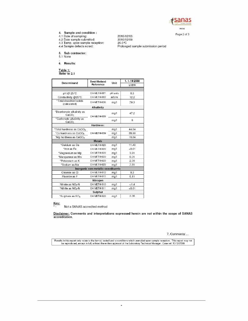
BH19 Buiskop 464-KR -24.85941 28.31550 In Use 110 6.95 E-Sub 2500l per day Used for domestic and irrigation vegetables in tunnes, approximately 1 ha under drip irrigation sample L1219
BH20 Buiskop 464-KR -24.85896 28.32147 Not in use 18 2 Not Equiped Previously used for the irrigation of crop; Overlfowed during the 2002 floods
BH21 Buisfontein 451-KR -24.83189 28.34294 In Use 45 2.7 E-Sub 1200l per day Used for domestic purposes Not submitted
BH22 Buiskop 464-KR -24.85075 28.31122 In Use E-SubUsed for domestic purposes for 2 households
and the irrigation of 10 ha of grazing fields
Tank re-filled automatically; Waterfall along north-western border of site; Water also used to provide water to
game
BH23 Buiskop 464-KR -24.85105 28.31148 Not in use Deeper than 50 m 11.25 Not Equiped Borehole will be used as a back-up in the future
BH24 Buiskop 464-KR -24.85105 28.34683 In Use 96 27.9 E-Sub Max. Capacity at Marula is 800 beds, swimming pool and restaurant facilities
Dam 11 Buisfontein 451-KR -24.81173 28.33915Build by the Italian prisoners; cement dam with overflow; still in good condition; used as a retention dam and as
a game watering point
BH25 Buisfontein 451-KR -24.80933 28.33870 In Use 90 6.75 E-SubAll boreholes are combind for domestic and the irrigation of gardens at different overnight facilities, lodge and
restaurant; Automatic re-fill of tanks; 2 x 30 000l and 2 x 20 000l tanks; Very strong flow
BH26 Buisfontein 451-KR -24.80750 28.32922 In Use 28.1 Primary borehole
Dam 12 Buisfontein 451-KR -24.81218 28.32255 Used for Game watering
Dam 13 Buisfontein 451-KR -24.81655 28.32749 Retention dam, Stocked with fish and used as a game watering point, concrete dam wall with overflow.
BH27 Buisfontein 451-KR -24.82379 28.32394 In Use 130 14.35 E-Sub Approximately 1 500l per day Used for Domestic and garden purposes at smallholding; Various new trees planted at and along the household
BH28 Buisfontein 451-KR -24.82412 28.32591 In Use 12.85 E-Sub Approximately 1 200l per day Used for Domestic and garden purposes at smallholding
BH29 Buisfontein 451-KR -24.82664 28.34218 In Use 8.42 E-Sub Approximately 1800l per dayWas previously used for the irrigation of 0.5 ha sitrus trees; Currently in the process of new owners that will not
be utilized the farm for agricultural purposes
BH30 Buisfontein 451-KR -24.85616 28.33352 Not in use 150 12.75 Not equiped Was previously drilled to be used for the irrigation of crops
BH31 Buisfontein 451-KR -24.85387 28.32674 Not in use 12 Not equipedWas previously used for the irrigation of crops, is currently still sealed, was not able to determine a static water
level
BH32 Buisfontein 451-KR -24.85279 28.32679 Not in use 17 Not equipedWas previously used for the irrigation of crops, is currently still sealed, was not able to determine a static water
level
BH33 Buisfontein 451-KR -24.85294 28.32670 Not in use 16.35 8.35 Not equiped Was previously used for crop cultivation
BH34 Buisfontein 451-KR -24.85294 28.32670 Not in use Not equipedWas previously used for the irrigation of crops, is currently still sealed, was not able to determine a static water
level
BH35 Buisfontein 451-KR -24.85295 28.32660 Not in use 6 No Water Not equiped Was previously used for crop cultivation
BH36 Buisfontein 451-KR -24.85314 28.32671 Not in use Not equipedWas previously used for the irrigation of crops, is currently still sealed, was not able to determine a static water
level
BH37 Buisfontein 451-KR -24.85429 28.32421 In Use 21 9.85 E-Sub Approximately 2 500l per day Used for Domestic purposes and watering for cattle
BH38 Buisfontein 451-KR -24.85422 28.32401 Not in use Not equipedWas previously used for the irrigation of crops, is currently still sealed, was not able to determine a static water
level
BH39 Buisfontein 451-KR -24.85435 28.32396 Not in use 11 8.87 Not equiped Was previously used for crop cultivation
BH40 Tweefontein 463-KR -24.82900 28.35564 In Use 120 12.5 E-Sub All the boreholes together BH40, 41, 42 and 43 delivers approximately 180 000l per week during the dry season; with each plant requiring approximately 180l per dayNo Photo
BH41 Tweefontein 463-KR -24.82828 28.35632 In Use 140 8.03 E-Sub No Photo
BH42 Tweefontein 463-KR -24.81741 28.35123 In Use 60 5.1 E-Sub 3rd photo
BH43 Tweefontein 463-KR -24.82075 28.35108 In Use 60 4.75 E-Sub 4th photo
BH44 Tweefontein 463-KR -24.82639 28.35855 Not in use 120 2.65 Not equiped 1st photo
BH45 Tweefontein 463-KR -24.81615 28.35020 In Use 60 2.3 E-Sub Approximately 2000l per day Water used for Domestic purposes; 2nd photo
Sewage Treatment
PlantKlein Kariba -24.85105 28.33077 In Use
Photos taken in 8 compass directions; the water from the sewage plant will be re-used for the irrigation of the
mini-gholf course; In peak times the excess water will be pumped to the evaporation Dam 14
BH46 Buiskop 464-KR -24.85290 28.33202 In Use 80 E-Sub 126 000l per day Used for domestic use for approximately 140 staff members living permanently at Klein Kariba Sample L699
Dam 14 Buiskop 464-KR -24.85184 28.33279Evaporation dam for treated sewage during peak periods, less than 70m from domestic water resource BH46;
Alternative must be investigated
BH47 Buiskop 464-KR -24.84888 28.33352 In Use 80 7.85 E-Sub 82 500l per day for both BH47 and 48 Back-up resource - Used for domestic and garden purposes, approximately 55 units with gardens
BH48 Buiskop 464-KR -24.84594 28.33151 In Use 80 53.9 E-Sub In combination with BH47 Primary resource - Used for domestic and garden purposes, approximately 55 units with gardens
Dam 15 Buiskop 464-KR -24.84809 28.32934 Retention dam for Spring water and perennial stream
Spring 1 Buiskop 464-KR -24.83744 28.32926 In Use Mono-pump 414 000l per day
The spring is the main water resource of Klein Kariba; The water does not have a good taste and must be
treated before use (Cl); This resource almost went dry during the previous dry season in 2007-2008, an
alternative or back-upsource were therefore investigated, it was decided on BH50; These resources BH50 and
Spring 1 supplies water to approximately 276 units with gardens.
Sample L695
BH49 Buiskop 464-KR -24.83498 28.33038 In Use 50 10.92 E-Sub 30 000l per dayThis borehole provides water for approximately 25 tent units with between 6-12 children per tent during peak
periods
BH50 Valencia 449-KR -24.82916 28.32217 In Use 250 19.85 E-Sub In combination with Spring 1 This borehole will be lost to Klein Kariba if the development is to take place
BH51 Valencia 449-KR -24.83008 28.31643 In Use 65 39.9 E-Sub Water for approximately 250 people This borehole will be lost to Klein Kariba if the development is to take place Sample L698
Main Tank Buiskop 464-KR -24.83331 28.33173 1 x 350 000l steel tank which will be used for both Spring 1 and BH50.
Dam 16 Buiskop 464-KR -24.83653 28.33202 Retention dam above waterval and restaurant
BH52 Buiskop 464-KR -24.856333 28.317917 Not in use 36 Mono-pump 0 Piet Lubbe 2 - estimated at >50 000L/hr, previous used for irrigation
BH53 Buiskop 464-KR -24.854817 28.315967 Not in use 38 Not equiped 0 Piet Lubbe 1 - borehole from old homestead, very good WQ, >50 years V. GOOD
BH54 Buiskop 464-KR -24.856750 28.317767 Not in use Not equiped 0 Piet Lubbe 3 - under the fig tree, sealed
BH55 Buiskop 464-KR -24.852883 28.321133 In Use 23.8 E-Sub 2500 l/day DR Wessels - low yielding, but dependant on the water
BH56 Buiskop 464-KR -24.854550 28.324000 Not in use 7.5 Not equiped 0 Anton - drilled 02/03/1983, previously used for irrigation
BH57 Buiskop 464-KR -24.866167 28.323100 Not in use closed Windpump 0 Ronvil 1 - very old windpump
BH58 Buiskop 464-KR -24.864483 28.321450 In Use obstructed E-Sub 15 000l/day Ronvil 2
BH59 Buiskop 464-KR -24.868317 28.322300 Destroyed 0
BH60 Buiskop 464-KR -24.864017 28.315200 In Use E-Sub 2 500 l/day Domestic water use - Humpreys Pig Farming
BH61 Buiskop 464-KR -24.868083 28.315333 In Use 10.84 E-Sub 2 500 l/day Steve Horen - Domestic and garden use
BH62 Buiskop 464-KR -24.868350 28.314717 In Use obstructed E-Sub 10 000 l/day Ice making in the summer months
BH63 Buiskop 464-KR -24.876333 28.316217 In Use 8.9 E-Sub 2 500 l/day Cattle watering with new domestic dwelling planned
Klein Kariba Water Supply: Geohydrological Assessment, and Groundwater Flow Modelling
AGES -8-
Figure 1: Summary of Borehole Census Results

Klein Kariba Water Supply: Geohydrological Assessment, and Groundwater Flow Modelling
AGES -9-
Figure 2: Regional Geological Setting

Klein Kariba Water Supply: Geohydrological Assessment, and Groundwater Flow
AGES
Figure 3: Rainfall Data for station 0589594
Klein Kariba Water Supply: Geohydrological Assessment, and Groundwater Flow Modelling
-10-
ata for station 0589594

Klein Kariba Water Supply: Geohydrological Assessment, and Groundwater Flow Modelling
Africa Geo-Environmental Services (Pty) Ltd. 11
3 RESOURCE EVALUATION
3.1 Existing Information
In 2008 a geohydrological investigation was completed where a number of boreholes
were identified, and tested to provide water for a proposed development on portion 1 of
Valencia 449-KR. (See unpublished Geo-Logic report G2007/149 attached as appendix
A).
Although both the area and the scope of the development are redefined, the two
boreholes (BH01, and BH02) were successfully tested, and recommended for
groundwater abstraction. Based on the current water levels (comparable with the initial
findings), the yield tests are deemed valid, and thus the boreholes were not re-tested as
part of this investigation.
Utilization recommendations are made with the aim of providing a sustainable water
supply, even during prolonged periods when the annual rainfall is below average.
It should be noted that the boreholes evaluated are existing boreholes, and Messrs
AGES can take no liability for borehole stability during long-term use. Borehole stability is
related to the correct installation of sufficient, suitable casing to ensure that zones of
weathering and fracturing are adequately protected for sidewall failure. Lower pumping
yields over longer pumping schedules reduces the water level fluctuations in the
borehole, and may reduce the chance of sidewall collapse in unstable boreholes.
During the current study, and in this report, the existing boreholes are re-numbered as
follows:
• BH01 (static water level was 32.7m) is now – BH51 (water level 39.9m)
• BH02 (static water level was 12.3m) is now – BH50 (water level 19.8m)
It is noted that when the boreholes were initially tested in 2008, they were not in use, but
were equipped based on the recommendations and have been in use since.
The following table is an extract from report G2007/149 and summaries the utilisation
recommendations for the two boreholes located on Valencia.
Table 3: Borehole Utilisation Recommendations
Borehole
Number
Previous
Borehole
Number
(G2007/149) Latitude Longitude
Rec
Abstraction
Rate (l/sec)
Duty Cycle
(hr/day)
Max Daily
Abstraction
(m3/day)
Dynamic
Water
Level
Water Level
(mbdl)
BH 51 BH01 24.83008 28.31643 1.4 24 121 53Was 32.7m,
now 39.9m
BH 50 BH02 24.82916 28.32217 1.2 24 104 47Was 12.3m,
now 19.8m
TOTAL 225

Klein Kariba Water Supply: Geohydrological Assessment, and Groundwater Flow Modelling
Africa Geo-Environmental Services (Pty) Ltd. 12
3.2 Regional Water Quality
Six regional water samples were collected during the initial investigation:
• Sample 1 – (L695) - The spring water currently used by Klein Kariba
• Sample 2 – (L696) - BH07 at Emmarentia Resort (east of the development)
• Sample 3 – (L697) - BH12 Bospoort Smallholdings (west of the development)
• Sample 4 – (L698) - BH51 Valencia portion 1 (development area)
• Sample 5 – (L699) - BH46 Borehole on the Zebediela Fault
• Sample 6 – (L701) - BH02 Valencia Smallholdings
A seventh water sample was collected for background water quality based on the
concerns raised by water users on the Bospoort Smallholdings southwest of Klein Kariba.
• Sample 7 – (L1219) - BH19 Bospoort Smallholdings (southwest of the development)
The results of the water quality assessment (attached as appendix C) are plotted on a
Stiff Diagram (Figure 4) presenting a simplified plot to illustrate the possible relationship of
the water on site.
Figure 4: Groundwater Fingerprint
Based on the water quality results, the following is noted:
• The water sampled at BH46, along the Zebediela Fault has a different groundwater fingerprint
o The local geological setting thus has a significant influence on the groundwater quality
• The water in all cases is deemed to be of Good Quality (class 1), and suitable for domestic use
• The groundwater (with the exception of BH46) has a low pH, and may be aggressive (corrosive) to geysers, metal pipes, and cement
0.00
0.50
1.00
1.50
2.00
2.50
3.00
3.50
K Mg Ca Na --- Cl HCO3 SO4
meq
/l
Groundwater Fingerprint
1
2
3
4
5
6

Klein Kariba Water Supply: Geohydrological Assessment, and Groundwater Flow Modelling
Africa Geo-Environmental Services (Pty) Ltd. 13
The chemical character of the groundwater samples is deemed to be consistent with the
local geology of the area, with Magnesium and Calcium being the prominent cations
present in the water.
BH19 (sample 7) and BH12 (sample 3), both collected on the Bospoort Smallholdings
southwest of Klein Kariba have the same fingerprint, and a very similar water chemistry
composition (see appendix C). The results of the water quality analysis do support
comments by local water users that the water is indeed of a very good quality (Ideal water
quality for domestic use). The TDS of groundwater collected at BH19 is less than 80mg/ℓ,
total hardness less than 45mg/ℓ, and a nitrate concentration falling below the minimum
detection limits of the laboratory.
4 REGIONAL GROUNDWATER POTENTIAL
4.1 General
To ensure the sustainability of a groundwater resource, one needs to gain an
understanding of regional flow patterns, groundwater - surface water interactions and
variations in groundwater quantity in time and space.
4.2 Scale of the Abstraction
Based on the requirements of the Department of Water Affairs, the initial regional
assessment is required to determine the necessary information required to assess a new
water use license application. Study area parameters are summarised in Table 4 below.
Table 4: Summary of the scale of Abstraction
Available Groundwater (m3/day) based on various models
Study AreaDWA Category of
Abstraction
Area (m2) Factor 6293983
Resource Potential (m) 0.037 638.0 127%
Resource Potential (m) 0.050 862.2 94%
Harvest Potential (m3/km/a) 10000 172.4 469%
Harvest Potential (m3/km/a) 15000 258.7 313%
GA 75 129.3 626%
GRA 11 (recharge - m) 0.022 379.4 213%
Wet Season Exploitation (m3/m
2/a) 0.0273848 472.2 171%
Dry Season Exploitation (m3/m
2/a) 0.0249116 429.6 188%
Comments Easy to justifyBased on a total water
demand of 809m3/day

Klein Kariba Water Supply: Geohydrological Assessment, and Groundwater Flow Modelling
Africa Geo-Environmental Services (Pty) Ltd. 14
Size of the Property = 6 293 983 m2
Recharge = various (based on different models)
Existing Water Use = 326 m3/day (at the existing resort)
New Use = 111 m3/day (437 m3/day after upgrade at the existing resort
= 372 m3/day (at the new development)
Scale of Abstraction = with all recharge scenarios >100%
Category C
Since with all recharge scenarios the abstraction ratio exceeds 100% (category C), a
detailed geohydrological study is required. A numerical model was initiated based on the
high abstraction ratio for a development that requires water for primary domestic
application.
4.3 Water Demand
A joint water demand is used for the study based on the relationship between the
proposed development and the existing Klein Kariba Resort (currently two of the water
supply boreholes for Klein Kariba are located on the proposed development area).
The water demand for the existing resort (including planned future expansion) is
calculated at 437 648 ℓ/day (existing use is estimated at 326 012 ℓ/day), and the proposed
development has an estimated water demand of some 371 815 ℓ/day. These volumes are
combined to define the joint water demand (in the order of 809m3/day) which is used as
the maximum water demand for the study.
4.4 Groundwater Model
A conceptual groundwater model was developed to determine and predict the regional
groundwater flow based on an understanding of the regional geological and
geohydrological setting. A numerical groundwater model was then developed. Using
measured groundwater levels, and existing groundwater abstraction values, the model
was calibrated to reflect and geohydrological conditions on site.
Based on the results of the calibrated numerical model, various abstraction scenarios
are simulated, and the influence on the regional geohydrology is calculated, and used to
predict the sustainability of the proposed abstraction. It is noted that when assumptions
are made in the model, or where reference values are used, a conservative approach is
followed, hence the groundwater sustainability is underestimated rather than
overestimated resulting in a high degree of assurance.
The groundwater model was developed, and initially five abstraction scenarios were

Klein Kariba Water Supply: Geohydrological Assessment, and Groundwater Flow Modelling
Africa Geo-Environmental Services (Pty) Ltd. 15
successfully simulated based on a total additional expected abstraction of 4.3ℓ/sec
(375m3/day) at the new development. A sixth scenario was then simulated based on the
total water demand (809m3/day) of not only the new development, but also the proposed
upgrades at the existing resort. Details of the modelling process are reported fully in the
unpublished AGES report AS-R-2010-03-15 attached as appendix B.
4.5 Model Scenarios
The following five model scenarios were initially simulated:
1. Scenario 1: The pumping of BH50 and BH51 at the maximum recommended rate
(24h cycle) by GeoLogic (Kruidenier, 2008). BH50 pumps at 104m3/d and BH51 at
121m3/d.
2. Scenario 2: The pumping of BH50 and BH51 at the reduced 12h rate
recommended by GeoLogic (Kruidenier, 2008) BH50 pumps at 73m3/d and BH51
at 86m3/d.
3. Scenario 3: The development of a deep production borehole on the Zebediela
Fault near the Klein Kariba entrance to augment the supply to the proposed
development. This borehole will augment supply with 216m3/d to supply the total
water demand from groundwater alone.
4. Scenario 4: The total volume of 375m3/d is abstracted from the proposed new
borehole on the Zebediela Fault.
5. Scenario 5: The initial total water demand for both Klein Kariba and the proposed
development was 701m3/d. Klein Kariba currently depends on the water from
Spring 1 to a large extent for their water demand. Should the spring dry up due to
extended periods of below average groundwater recharge, Klein Kariba would
experience severe water shortages. Therefore this scenario models the total
demand of 701m3/day from a proposed well field on the Zebediela Fault.
6. A sixth scenario was simulated based on the revised combined water demand of
the proposed development and the upgrading of the existing facilities. A total
water abstraction of 809m3/day was simulated from a proposed well field on the
Zebediela Fault.

Klein Kariba Water Supply: Geohydrological Assessment, and Groundwater Flow Modelling
Africa Geo-Environmental Services (Pty) Ltd. 16
4.6 Hydraulic Parameters
The hydraulic zones and the parameters used in the numerical model are summarised in
Table 5 below.
Table 5: Hydraulic zones in the calibrated model
No
Hydraulic
zone Layer
Horizontal
Conductivity
Kx,y (m/d)
Saturated
Thickness
(m)
Transmissivity
(m²/d)
Recharge
(% of
MAP)
Recharge
(mm/year)
Recharge
(m/d)
1
Waterberg
plateau 1 0.028 250 7 3% 0.075 4.7671E-5
2
Waterberg
outcrop 1 0.028 250 7 2.5% 0.0625 3.9726E-5
3
Waterberg
valley 1 0.08 250 20 2.5% 0.0625 3.9726E-5
4
Schrikkloof
formation 1 0.08 250 20 2.5% 8.75 3.9726E-5
5
Clarens
formation 1 0.16 250 40 2.5% 14.5 3.9726E-5
6
Letaba
formation 1 0.16 250 40 2.5% 45 3.9726E-5
4.7 Modelling results
4.7.1 Scenario 1
From the results of the transient modelling (simulated for a period of 25 years) for
scenario 1, it can be seen that the modelled effect at the springs is a drawdown in
hydraulic head of between 1.0 and 1.5 m after 25 years. During the first five years very
little impact should be experienced, but after 25 years a slight reduction in the spring flow
might be expected as a result of the pumping of boreholes BH50 and 51 at the maximum
recommended rate.
The water balance indicates that all of the boreholes combined (including the proposed
abstraction of scenario 1) would total a volume of 394m3/d. It is noted that the spring
outflow used by Klein Kariba is not included as borehole use in the model. The
conservative recharge estimates used totals a groundwater recharge volume of
5,556m3/d. The total water balance factoring in all of the in and outflows indicates a

Klein Kariba Water Supply: Geohydrological Assessment, and Groundwater Flow Modelling
Africa Geo-Environmental Services (Pty) Ltd. 17
positive water balance exists after 25 years with the total inflows exceeding the total
outflows by 28m3/d.
4.7.2 Scenario 2
From the results of the transient scenario (simulated for a period of 25 years), it can be
seen that the springs could be impacted by a decrease in the water table of around 1.0 m
after 25 years. The impact expected after 25 years of pumping would be a drawdown of
less than one metre. Similar to scenario 1, the first five years will see very little impact on
the hydraulic head at the springs.
Compared to the total groundwater abstraction in scenario 1 of 568m3/d, during scenario
2 the abstraction would reduce to 328m3/d. This is a reduction of 66m3/d just by
decreasing the proposed pumping rates of BH50 and 51. The total water balance reflects
a positive balance of 28m3/d, which is similar to scenario 1. This can be ascribed to the
balance of the groundwater abstraction that is now being lost through drains (springs) to
reach the same equilibrium.
4.7.3 Scenario 3
The transient results for scenario 3 indicate a slight increase in the effect that would be
realised at the springs when compared to scenario 2. The final impact that is modelled is
a drawdown in hydraulic head at the springs of 1.0 m after 25 years of pumping.
Scenario 3 assumes that the total water demand for the proposed development (375m3/d)
will be abstracted from groundwater, bringing the total volume of groundwater abstraction
for the modelled area to 544m3/d. This has the effect that less water is available to
escape through drains and other outflows. The total water balance after 25 years
indicates that the total inflows exceed the total outflows by 27m3/d.
4.7.4 Scenario 4
The impact on the hydraulic heads near the springs would be less than 0.5 m after an
estimated 25 years. This scenario is deemed to be sustainable based on the conservative
variables used in the model calibration.
According to the water balance for scenario 4 the total groundwater abstraction is
569m3/d which is 25m3/d more than in scenario 3 since the 25m3/d that is currently being
abstracted from BH51 (used in the calibrated model) is included in the total volume of

Klein Kariba Water Supply: Geohydrological Assessment, and Groundwater Flow Modelling
Africa Geo-Environmental Services (Pty) Ltd. 18
groundwater abstraction for BH51 as per the yield recommendations used in scenarios 2
and 3. The water balance indicates that a positive water balance exists after 25 years
with the total inflows exceeding the total outflows by 26m3/d.
4.7.5 Scenario 5
Although the abstraction is almost doubled compared to scenario 4, the impact on the
hydraulic heads near the springs would be less than 0.8 m after an estimated 25 years.
This scenario is thus deemed to be sustainable based on the conservative variables used
in the model calibration.
The total groundwater abstraction from wells increased from 569 m3/d in scenario 4 to
894m3/d in scenario 5. Even after this significant increase the water balance remains
positive with total inflows exceeding outflows by 26m3/day.
4.7.6 Scenario 6
Groundwater abstraction of some 809m3/day is simulated from a proposed well field
developed on the Zebediela Fault. This water is used as the primary water source for not
only the upgrading of the existing resort, but also as the primary water supply to the
proposed new development.
Based on the model, after 25 years, BH19, located on the Bospoort smallholdings will
show a 4.2 meter loss in water level due to the proposed abstraction along the Zebediela
fault. A borehole located on Dr Wessels’ smallholding (BH55), will show a water level
drop of some 4.8m, while the borehole (BH53), on Mr Lubbe’s property will show a water
level drop of some 4.6m after 25 years (transient flow).
Based on the results of the model, the hot water spring at Bela Bela Forever Resorts will
experience less than 0.5m of head loss after 25 years due to the proposed abstraction at
the Klein Kariba Resort.
4.8 Groundwater Potential
The results from the numerical model are positive for the abstraction of groundwater for
water supply to both the proposed development and the existing resort.
The various scenarios do however indicate that the abstraction of groundwater should be
focused along the Zebidelia Fault to the south of the site, rather than from boreholes

Klein Kariba Water Supply: Geohydrological Assessment, and Groundwater Flow Modelling
Africa Geo-Environmental Services (Pty) Ltd. 19
located to the north of the site, close to the springs as abstraction from these boreholes in
the north will have the greatest impact on the springs.
The abstraction of 809m3/day, deemed to be the total water requirement of both the
proposed development and the resort is thus deemed to be sustainable with a positive
water balance.

Klein Kariba Water Supply: Geohydrological Assessment, and Groundwater Flow Modelling
Africa Geo-Environmental Services (Pty) Ltd. 20
5 CONTAMINATION RISK ASSESSMENT
5.1 Possible sources of contamination
The possible groundwater contamination sources on the site are limited to the disposal of
on-site sanitation effluent, and the temporary storage of solid waste.
5.2 Risk Assessment
The risk of contamination to the local aquifer was determined during the previous
geohydrological assessment (see report G2007/149 attached as appendix A).
The following extracts from the report summarise the findings:
• The aquifer is classed as a minor aquifer region and can be described as a moderately yielding aquifer system of variable water quality
• A moderate tendency or likelihood does exist for contamination to reach a specific position in the groundwater system after introduction at some location above the uppermost aquifer
• The aquifer is rated to have a medium susceptibility to contamination
• The GQM index of the area is rated at 4, with medium protection level needed
• The hydraulic flow time for water to reach the groundwater table is approximately 2 days. This is not regarded as enough for the attenuation of bacteria and viruses, thus the use of French drains or simplistic septic tanks cannot be recommended.

Klein Kariba Water Supply: Geohydrological Assessment, and Groundwater Flow Modelling
Africa Geo-Environmental Services (Pty) Ltd. 21
6 CONCLUSIONS
• The total study area is defined by the extent of the groundwater model boundary, and is approximately 138km2 in extent.
• The proposed development is restricted to portion 1, 2, 3, and 4 of the cadastral farm Valentia 449-KR covering an area of approximately 1km2.
• The existing water demand will increase at the existing resort due to the upgrading of the facilities.
• Due to the relationship between the proposed development, and the Klein Kariba Resort, the area of the resort (portion 87 of Buiskop 464-KR) of some 5.3km2 is included in the investigation for the development of proposed boreholes.
• The study area falls within the Limpopo Catchment Management Area (CMA), within Quaternary Catchment Area (QCA) A23G.
• Natural vegetation covers the majority of the study area, with the development of wildlife smallholdings to the north of the area. Small scale agriculture, with isolated incidence of irrigation is noted to the south west of the area.
• The area is located in the summer rainfall region. The data yielded an average rainfall of 581 mm/a, but the annual rainfall is very erratic, with annual figures ranging from less than 300 mm to over 1 000 mm.
• The region experiences evaporation figures between 1 700 and 1 800 mm/a
• The prominent sandstone outcrops to the north is predominantly medium to coarse grained sandstone, pebble sandstone and conglomerate from the Swaershoek Formation of the Waterberg Group sediments. Finer grained sedimentary rocks like shale and siltstone also occur in this formation.
• The flat lying areas to the south are fine grained red to cream coloured sandstone of the Clarens Formation of the Karoo Super Group.
• A regionally significant fault, the Zebediela Fault that extents for many kilometres defines the contact between the Waterberg Group, and the Karoo Super Group.
• Further south the Clarens Formation is bound by the overlying by volcanic and sedimentary rocks of the Letaba Formation of the Karoo Super Group.
• The underlying aquifer is described as a Fractured Type Aquifer underlying the Waterberg sandstone and an Intergranular and Fractured Type aquifer underlying the Clarens and Letaba Formations.
• In and around the area of investigation a borehole yield median of between 0.5 and 2.0 L/s can be expected based on existing borehole data.
• According to the hydrogeological map, the Letaba Formation further to the south can yield in excess of 5.0 L/s.
• The Zebediela Fault is deemed to be a significant geohydrological feature, with Transmissivity an order of magnitude greater than the surrounding lithology. Borehole yields of greater than 5 ℓ/sec can be expected
• A numerical model was initiated based on the high abstraction ratio (abstraction/recharge > 100%) for a development that requires water for primary domestic application.
• Based on the relationship between the proposed development and the existing Klein Kariba Resort (currently two of the water supply boreholes for Klein Kariba are located on the proposed development area), the water demand for the existing

Klein Kariba Water Supply: Geohydrological Assessment, and Groundwater Flow Modelling
Africa Geo-Environmental Services (Pty) Ltd. 22
Resort is calculated at 437 648 ℓ/day (including planned future expansion), and the proposed development 371 815 ℓ/day are combined to define the joint water demand of 809m3/day.
• The following six model scenarios were simulated:
a. Scenario 1: The pumping of BH50 and BH51 at the maximum recommended rate (24h
cycle) by GeoLogic (Kruidenier, 2008). BH50 pumps at 104m3/d and BH51 at 121m3/d.
b. Scenario 2: The pumping of BH50 and BH51 at the reduced 12h rate recommended by
GeoLogic (Kruidenier, 2008) BH50 pumps at 73m3/d and BH51 at 86m3/d.
c. Scenario 3: The development of a deep production borehole on the Zebediela Fault near
the Klein Kariba entrance to augment the supply to the proposed development. This
borehole will augment supply with 216m3/d to supply the total water demand from
groundwater alone.
d. Scenario 4: The total volume of 375m3/d is abstracted from the proposed new borehole on
the Zebediela Fault.
e. Scenario 5: The total water demand for both Klein Kariba and the proposed development is
701m3/d. Klein Kariba currently depends on the water from Spring 1 to a large extent for
their water demand. Should the spring dry up due to extended periods of below average
groundwater recharge, Klein Kariba would experience severe water shortages. Therefore
this scenario models the total demand of 701m3/day from a proposed well field on the
Zebediela Fault.
f. Scenario 6: The revised combined water demand of the proposed development and the
upgrading of the existing facilities with a total water abstraction of 809m3/day was
simulated from a proposed well field on the Zebediela Fault.
• Although the two existing boreholes (previously tested) located on the development area are deemed suitable for groundwater abstraction to a daily maximum of 225m3, the greater impact on the springs (1m – 1.5m over a 25 year period) should limit the utilisation of these boreholes in preference to proposed boreholes along the Zebediela fault where the impact on the springs is far less (less than 0.8m over 25 years)
• The abstraction of 809m3/day, deemed to be the total water requirement of both the proposed development and the resort is deemed to be sustainable with a positive water balance
• The local groundwater gradient is from the north-west towards the south.
• The water sampled at BH46, along the Zebediela Fault has a different groundwater fingerprint, confirming that the groundwater reflects the different geological setting
• The water in all cases is deemed to be of Good Quality (class 1), and suitable for domestic use

Klein Kariba Water Supply: Geohydrological Assessment, and Groundwater Flow Modelling
Africa Geo-Environmental Services (Pty) Ltd. 23
• The groundwater (with the exception of BH46) has a low pH, and may be aggressive (corrosive) to geysers, metal pipes, and cement
• The chemical character of the groundwater samples is deemed to be consistent with the local geology of the area, with Magnesium and Calcium being the prominent cations present in the water
• Results of analysis of groundwater collected on the Bospoort Smallholdings southwest of Klein Kariba supports comments by local water users that the water is indeed of a very good quality (Ideal water quality for domestic use). The TDS of groundwater collected at BH19 is less than 80mg/ℓ, total hardness less than 45mg/ℓ, and a nitrate concentration falling below the minimum detection limits of the laboratory.
• The aquifer is classed as a minor aquifer region and can be described as a moderately yielding aquifer system of variable water quality
• A moderate tendency or likelihood does exist for contamination to reach a specific position in the groundwater system after introduction at some location above the uppermost aquifer
• The aquifer is rated to have a medium susceptibility to contamination
• The GQM index of the area is rated at 4, with medium protection level needed
• The hydraulic flow time for water to reach the groundwater table is approximately 2 days. This is not regarded as enough for the attenuation of bacteria and viruses, thus the use of French drains or simplistic septic tanks cannot be recommended.

Klein Kariba Water Supply: Geohydrological Assessment, and Groundwater Flow Modelling
Africa Geo-Environmental Services (Pty) Ltd. 24
7 RECOMMENDATIONS
7.1 Groundwater Development
7.1.1 Existing Boreholes
• The existing boreholes should be numbered in the field according to the specifications of DWA in Limpopo, so that information can be entered on the National Groundwater Database, and that data can be managed on a regional basis.
• The existing boreholes BH50, and BH51 should only be used as a water supply for a limited period of no more than 5 years, while further groundwater development along the Zebediela fault takes place.
• Groundwater abstraction from borehole BH49 which currently abstracts 30m3/d (peak season) should be stopped. Borehole BH49 should be developed as a monitoring borehole for critical groundwater water level management near to spring 2. The information on the water level can be used to manage the abstraction from boreholes BH50, and BH51 to protect the springs.
• Water levels of water supply boreholes should be measured on a quarterly basis and archived for trend analysis.
• Water abstraction should be licensed with the DWA - (21a-taking water from a resource)
• Existing boreholes on the Klein Kariba Resort should be tested to confirm the aquifer properties, and to determine the sustainable groundwater yield
• Existing boreholes on the Klein Kariba Resort should be maintained as standby emergency water supply to the resort
• Although seasonal, the existing spring, and well point abstraction will continue to be an important water supply to the resort
7.1.2 New Boreholes
• All new boreholes should be numbered in the field according to the specifications of DWA in Limpopo, so that information can be entered on the National Groundwater Database, and that data can be managed on a regional basis.
• Valencia 449-KR
o No additional boreholes should be developed on the proposed development area, with management and restricted abstraction for the two existing boreholes.
• Klein Kariba Resort
o A detailed geophysical investigation should be initiated to determine the orientation and inclination of the Zebediela Fault
o Suitable drilling positions for exploration drilling should be targeted along the Zebediela Fault
o A borehole well-field should be developed along the Zebediela Fault to a cumulative maximum of 810m3/day (provision should be made for a standby borehole)
o The well field should target both deep water strikes, and more shallow water strikes.

Klein Kariba Water Supply: Geohydrological Assessment, and Groundwater Flow Modelling
Africa Geo-Environmental Services (Pty) Ltd. 25
� Should the fault be targeted at depth, there is a high possibility that heated water will be encountered, this in turn may supplement other recreational water demands at the resort
� Should the fault be targeted at more shallow depths, the potential groundwater yield from the well-field will meet the full water demand of 809m3/day.
7.1.3 Return Waste Water
• Treated water from sanitation systems may be used for the irrigation of gardens. Irrigation with waste or water containing waste should meet strict discharge requirements, and be licensed with the DWA (21e-irrigation with water containing waste as a controlled activity)
7.2 Water Quality
• It is recommended that water with low pH be treated with lime to elevate the pH to approximately 7.
o The sodium and calcium concentrations are sufficiently low so as not to have a negative effect on water salinity.
o The taste of the water will improve from slightly sour to a more palatable taste
• Mixing water from the proposed Zebediela well-field will also have a positive effect on water quality of groundwater abstracted from the Waterberg Sandstones.
7.3 On Site Sanitation
• A well head protection area (WHPA) is established to protect a borehole or spring from contact with pathogenic micro-organisms and chemical contaminants which can emanate from a source (e.g. septic system, etc). It is designed to protect the borehole or spring from chemical contaminants that may migrate to the borehole and typically includes a major portion of the recharge area or the capture zone (radius of 200m). It is therefore recommended that:
1. No waste storage facility to be located within 200 m from any borehole or spring.
2. No irrigation of water containing waste takes place within a 200 m radius from any borehole or spring.
3. On-site sanitation systems that do not rely on seepage for the disposal of liquids must be used.
7.4 Monitoring and Management
• Groundwater levels (rest and pump levels) must be monitored on a quarterly basis. Should the water level drop to within 2 metres of the pump intake during regular pumping, the pumping rate should be reduced. Results of recorded abstraction rates, abstraction volumes, and water levels may then be re-evaluated.
• Totalling flow meters must be installed on all production boreholes in order to monitor monthly abstraction volumes.
• An annual assessment of the groundwater quality, both microbial and macro-chemical, should be conducted to ensure that the water is potable, and suitable for domestic use.

Klein Kariba Water Supply: Geohydrological Assessment, and Groundwater Flow Modelling
Africa Geo-Environmental Services (Pty) Ltd. 26
8 REFERENCES
MIDGLEY, D C, PITMAN, W V and MIDDLETON, B J, 1994.
Surface water resources of South Africa 1990, Book of Maps. Water Research
Commission report number 298/1.2/94.
DEPARTMENT OF WATER AFFAIRS AND FORESTRY
Groundwater Resource Directed measures version 2.5.
VAN TONDER, G, KUNSTMANN, K, AND XU, Y (2000)
FC Method. Version 2. Institute of Groundwater Studies. University of Free State,
Bloemfontein.
KRUIDENIER, JHB (2008)
Geohydrological and Sanitation Risk Assessment Study for the Proposed Resort on
Portion 1 of the Farm Valencia 449-KR. (G2007/149)
SMIT, JJ (2010)
Klein Kariba Water Supply: Groundwater Flow Modelling Report (AS-R-2010-03-15)

-
Appendix A
Geohydrological Report
G 2007/149
-
Appendix B
Groundwater Modelling Report
AS-R-2010-03-15
-
Appendix C
Water Quality
Results

-

-

-

-
-

-

-
Appendix D
Geophysical Survey
Results

-
0.0
20.0
40.0
60.0
80.0
100.0
120.0
140.0
160.0
180.0
200.0
220.0
28400
28500
28600
28700
0 100 200 300 400 500
RE
S V
AL
UE
S (
in O
hm
per m
etr
e)
MA
G V
AL
UE
S (
in n
an
oT
esl
a)
DISTANCE (in metres)
MAGNETIC AND RESISTIVITY SURVEYS
Klein Kariba Line 1-S
Magnetic Data Resistivity Data
F
a
u
l
t
0.0
20.0
40.0
60.0
28600
0 100 200 300
RE
S V
AL
UE
S (
in O
hm
per m
etr
e)
MA
G V
AL
UE
S (
in n
an
oT
esl
a)
DISTANCE (in metres)
MAGNETIC AND RESISTIVITY SURVEYS
Klein Kariba Line 2-S
Magnetic Data Resistivity Data
F
a
u
l
t