geologi(;al survey department - bgs resources...
TRANSCRIPT

ANNUAL REPORT
of the
GEOLOGI(;AL SURVEY DEPARTMENT
For the year ended 31st December, 1961

5
GENERAL
(a) INTRODUCTION
THE year 1961 was an important year in the history of the Geological Survey Department for from 1st April, 1961 the recurrent expend
Iture of the Geological Survey became part of normal budget expenditure nnd with this Territorial acceptance of financial responsibility for re(Jurrent expenses the Geological Survey Department is now an integral part of normal Government services in the Bechuanaland Protectorate. Prior to this the Geological Survey, which was established on 1st April, 1948, had been financed with regard to both capital and recurrent expendIture by grants made under the Colonial Development and Welfare Act, In 1956 the transition from a wholly grant-aided development scheme to a Territorial responsibility commenced" when the Bechuanaland Protectorate Government began making a local contribution towards the J'ccurrent expenses of the Geological Survey. This contribution was gradually increased during the ensuing financial years until in 1961 the Bcchuanaland Protectorate Government became fully responsible for the recurrent expenditure of the Department. The recurrent costs of the development of underground water supply in the Bechuanaland Protectornte by drilling, which is controlled by the Geological Survey, was also borne by budget expenditure during 1961. Capital expenditure, however, for both this work and normal Geological Survey activities will continue to be borne by grants from Colonial Development and Welfare Funds until 31st March, 1963 when this expenditure will probably also become It
normal budget commitment, The work of the Geological Survey is directed along three main lines.
'1'hese can be summarised as Ca) geological mapping; Cb) mineral survey which includes field and laboratory examination of mineral occurrences, Hurvey of the potential coalfield areas of the Territory, rendering assistIlnce to operating mines and furthering the interest of mining and protipecting organizations in the Territory's mineral potential; and (c) the development of underground water supplies and general hydrogeological t:mrvey, In underground water development work the Geological Survey controls the Government Drilling Branch and is thus responsible for all Government water borehole drilling throughout the Territory, whether undertakim by contract or by Departmental methods, The actual role pla.yed by the Geological Survey in underground water development work is the siting of boreholes, following geological and geophysical ~urveys, and the drilling of the selected sites to the stage where productive boreholes can be passed to the Public Works Department who 1l1'C responsible for equipping ano. maintenance of pumping units.
The Geological Su~vcy Department has its headquarters at Lobatsi in the south-eastern portion of the Territory, These headquarters are provided with a mineralogical and chemical laboratory, drawing office facilities, a library and a small museum, The headquarters of the Drilling Branch Section are at Gaberones, 50 miles north of Lobutsi, where control of the Drilling Branch is under a Drill Superintendent who is directly responsible for the operation of this Branch to the DIrector of Geological Survey,

7
t.he initial results of the examination of the nickel occurrence there proved to be disappointing, but the company has been carrying out I'egional geochemical surveys following the discovery of other mmeral oecurrences there during the course of their earlier work. The GeoloJ{lcal Survey collaborated with Rhodesian Selection Trust Exploration III carrying out further work on the brine deposits present in the Sua p!ln section of the Makarikari.
(2) In the Batawana Tribal Territory, the grantee, Johannesburg Consolidated Investment Company, continued exploration work in certain Hulectcd areas.
(3) The B,P. Milling Corporation, holders of a Crown Grant conrOtTing prospecting and mining rights for manganese over the Bamalete 'l'ribal Territory, went into liquidation during the first half of the y(~ar. Following negotiations with the Chief and Tribe, a new Crown Cit'ant was issued during the year to the Bamalete Manganese Company which commenced operations at the Ootse mine in July.
(4) A Crown Grant awarding a petroleum exploration licence was negotiated by the Standard Vacuum Oil Company of South Africa Limited and three geologists of the company were active in certain HI'eas of the Territory for part of the year.
(5) De Beers Prospecting (Rhodesian Areas) Limited, with the Anglo American Corporation of South Africa as technical advisers, eontinued diamond prospecting operations over a large area of the Northern CrO\'v'n Lands and the Central (Ghanzi) Crown Lands.
(6) Cro\\'n Grants have been awarded to De Beers Prospecting (Rhodesian Areas) Limited for diamond prospecting rights over the Illtngwakctse, the Barolong, the Bakgatla and the Bamangwato Tribal 'I'(~rritories respectively. The Anglo American Corporation of South Africa, acting as their technical advisers, had commenced prospecting operations in the Barolong and the Bakgatla Tribal Territories respect~ ivuly by the end of the year.
(7) A short term Crown GraJlt was issued to a group of private Illdividuals for diamond prospecting rights over the Bamalete Tribal 'l'erritory.
(8) Onc short term Crown Grant issued for prospecting rights over a restricted area of the Southern Crown Lands lapsed during the yt!lll' and negotiations were in progress for diamond prospecting rights over the Bakwena Tribal Territory.
While lW new ·notable mineral occurrences were located, prospecting work continued at a steady pace throughout 1961. Certain of the Kmntees still have large areas to cover and the tempo of prospecting I'divity should be maintained throughout 1962.
With the completion of the new chemical laboratory block, and the appointment of a Chemist early in the year, there has been an 11l!:l'ease in the amount of work carried out in this sphere of DepartIlH'ntal activities. Much assistance was rendered to operating mines and 11 \! merous routine assays, largely determinations on manganese ore, w{~l'e undertaken, As mentioned above the output from the drawing orliec section was seriously curtailed following the resignation of the {ieo\ogical Draughtsman.
During 1961 underground water development work continued as in

8
previous years and during the year all drilling was carried out Departmentally and no contract work was undertaken. The total footage drilled by the Drilling Branch was 20,227 feet, of which 14,063 feet were drilled in productive bore holes. The yield developed overall was 84,170 g.p.h. A total of 104 boreholcs, including 5 boreholes drilled purely for brine testing purposes, were completed during 1961 as again~t 114 boreholes comp18ted during 1960. When allowance is made for boreholes abandoned for technical or other reasons and the brine testing boreholes are excluded the success ratio over all areas in the Protectorate during 1961 was 71 per cent. The slight reduction in footage and the reduced number of successful boreholes completed during 1961 compared with 1960 (64 compared with 90 in 1960) was largely due to a shortage of drilling staff, but was also due to the fact that much of the drilling undertaken in 1961 was in difficult ground-water areas with hard rock formations and the fact that one drilling rig was occupied throughout the year on deep test borehole drilling for Lobatsi water supply. In addition, a larger number of boreholes drilled in earlier programmes required cleaning prior to the installation of pumping equipment than in previous years (14 compared with 5 in 1960). During 1961 work continued to follow the lines set out for priorities for development of underground water supplies for the three year, 1960/63, period. Certain modifications were made to this programme during the year. Attempts were made, within the limitations imposed by lack of funds and staff, to carry out more detailed hydrogeological research work in certain selected areas of the Territory. As part of this work a systematic water sampling programme has been initiated.
Two geophysicists from the Geophysical Division of the Directorate of Overseas Geological Surveys carried out research geophysical studies in selected areas of the Territory during the year. The Geological Survey undertook a number of special investigations in the form of engineering geological surveys for projected dam sites in connection with the proposed transfer of the capital of the Bechuanaland Protectorate from Mafeking in the Cape Province to Gaberones.
The new chemical laboratory block which was started in 1960 was completed in March. Alterations were then carried out to the old office block to enlarge the drawing office and to provide a new enlarged optical laboratory, Alterations were also carried out in the library.
The Director and Mr. C. M. H. Jennings represented the Department at the first Inter-African Hydrology conference, held under the auspices of C.C.T.A., in Nairobi during January. The Geological Survey was represented at the Fourth Annual Congress of the Geological Society of South Africa, held in Johannesburg in April, by the Deputy Director and Mr. 1. Gerrard. The Director was an official delegate at thE' Southern Regional Geological Committee meeting of C.C.T.A., held in Pretoria during September. The Director also accompanied a special post-confere.nce excursion organized by the Geological Survey Department in South Afrka to the Richtcrsv8ld area of the Cape Province. The Deputy Director att.ended the Arid Zone Hydrology Conference, held in Athens in October under the auspices of the Scientific Hydrology Section of the International Union of Geodesy and Geophysics, as a. member of the United Kingdom delegation.

9
Dr. S. H. Shaw, Director of Overseas Geological Surveys and Geo~ logical Adviser to the Secretary of State, visited Geological Survey headquarters at Lobatsi during May. During Dr. Shaw's visit the geo M
physical team from the Geophysical Division of the Overseas Geological Hurveys, who were then working in th€' area south of Ghanzi in the tlorthMwestern Protectorate, were visited in the field. The visit to Ghanzi Wns made by air and the return by road across the central Kalahari. Dr. Shaw also visited the Moshaneng asbestos mine and the Kgwakgwe manganese mine in the Bangwaketse Tribal Territory. Discussions were held in Lobatsi with Dr. Shaw on general Geological Survey work Hnd organization. Dr. Shaw also held discussions at the Secretariat in Mufeking with the Resident Commissioner, Mr. R. P. Fawcus, on Geological Survey activities.
Mr. B. B. Braine, Parliamentary Under-Secretary of State for Commonwealth Relatione, visited Geological Survey headquarters at Lobatsi with the Resident Commissioner, Mr. R. P. Fawcus, during the course of a tour he made of the Bechuanaland Protectorate in August.
During 1961 numerous visits were again paid to Survey headquarters by representatives of mining companies and prospecting organhmtions who wished to examine geological maps and plans of various H!'cas and also to discuss the posf:libility of obtaining prospecting and rnlning rights over selected areas in the Protectorate,
(c) ORGANIZATION AND STAFF
The new constitution for the Bechuanaland Protectorate, under which an Executive Council, a Lf'gislutive Council and a separate African Council were established, came into effect on the 2nd May, 1961. With the adoption of the :new constitution new arrangements for the machinery of Government were introduced and a full Memher system adopted for t.he conduct of Government business, Under these new arrangementf; the Director of Geological Survey is now .formally responsible for the ndministration of the Department to the Member for Natural Resources und Industries.
There were no changes in the form of the est.ablishment of the Geological Survey during the ye~r. With the appointment of a Chemist In February, and a Geologist in September, the professional staff of the Department was brought up to full strength. Vacancies, however, «xisted for various periods of the year in certain field technical posts, III n,q,rticular there was a shortage of Drill Foremen throughout the perIod.
Mr. D. Green, Geologist, was absent on overseas leave from FebI'uary until July. Mr. M, T. Jones, Geologist, was absent on overseaR J""ve from April until September.
Mr. L. D. Lekalake was appointed to the vacant post of Chemist Itnd assumed duty in February.
Mr, R, Mason was appointed to the remaining vacant post of Geologist and assumed duty in the Protectorate during October.
Mr. J. H. Webb, Geological Draughtsman, resigned in August and this post was still vacant at the end of the year. Mr. E. C. Mare, formerly Drill Foreman on the establishment of the Drilling Branch

23
reconnaissance survey in the south-western Kgalagadi district. The opportunity was taken to re-examine outcrop areas at Mpathutlwa and Mabua a Sehubi pans between Tshabong and Tsane in this Kalahari l'egion.
At Mpathutlwa pan, some 65 miles north of Tshabong, Dwyka Series Lillite is exposed on the north-eastern side of the pan. The ill-sorted pebble assemblage includes quartzite, some banded ironstone, chert, jasper itnd jaspilitc in a calcareous matrix. Five miles north of Mpathutlwa at Mabua a Sehubi pan, a relatively extensive outcrop area is present consisting of reddish shales which are occasionally calcareous and interbedded red, fine-grained quartzites with a single limestone band. The Hediments have a near vertical dip with a general northerly strike and have been intruded by diabase. The correlation of this isolated outcrop of pre-Karroo System rocks presents great difficulties though a Lower Matsap Beds age can be very tentatively suggested.
IV UNDERGROUND WATER DEVELOPMENT
(a) GEOLOGICAL SURVEY ACTIVITIES
(i) Geneml During 1961 the Geological Survey continued to be responsible for
all Government water borehole drilling in the Territory. All drilling during 1961 was carried out by the Drilling Branch Section of the Geological Survey and no contract work was undertaken. Work has continued to follow the allocation of priorities decided on for the development of underground water supplies during the 1960/63 period, though certain modifications to this programme became necessary during the year in view of the fact that over the first 15-month period numerous boreholes had to be drilled outside the priority allocations. In the course of underground water developm8nt work geological and geophysical surveys prior to drilling were carried out in the Batawana, Bamangwato, Bakgatla, Bakwena, Bangwaketse and Bamalete Tribal Territories, and the Ghanzi District. Surveys have also been carried out for various Government camps and institutions, notably in connection with the Lobatsi township water supply.
During the year under review 95 boreholes (not including 5 boreholes drilled for brine testing purposes) were drilled on sites selected by geological and geophysical methods by officers of the Geological Survey in various areas of the Protectorate. Of these 7 boreholes had .to be l~batldoned for technical reasons. Of the remaining 88 sites, 64 boreholes were successful, representing a success ratio of 73% over all areas in the Protectorate. The success ratio shows a slight decrease com~ pared with the success ratio achieved during 1960, la.rgely due to the fact that a considerable amount of drilling was carried out in difficult ground-water areas in both the northern and north-western Protectorate.
An apPointment was made to the post of Scientific Assistant in July. 'J'his officer will be employed on detailed geophysical surveys in difficult ground-water areas. Much of the period since his appointment has been sf/ent on training in the various geophysical techniques employed by the Geological Survey, but a start was made during the last quarter of the year on detailed surveys in selected areas.
24
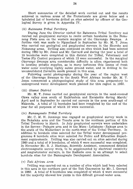
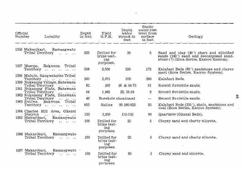
Short summaries of the detailed work carried out and the results achieved in various areas of the Protectorate are given below and a tabulated list of boreholes drilled on sites selected by officers of the Geological Survey is given in Appendix IV.
(ii) Batawana Tribal Territory During June the Director visited the Batawana Tribal Territory and
carried out geophysical surveys to resite certain boreholes in the Noka~ neng Flats area on the western margins of the Okavango Swamps. A further visit was made to Ngamiland in September by Mr. M, T. Janes who carried out geological and geophysical surveys in the Shorobe and Nokaneng areas. Drilling also continued on sites which had been selected during 1960 by Mr. Jones and Mr. Gerrard and during the year a total of 18 boreholes were completed in this district for Tribal, Veterinary and Tsetse Fly Control purposes of which 13 were successful. In the marginal Okavango Swamps area considerable difficulty is often experienced both in locating potable supplies, as in many instances thin lenses of fresh water occur overlying highly saline ground water, and in drilling in the un consolidated fluviatile sands present in this area.
Following aerial photography during the year of the region west of the Okavango Swamps to the South West African border Mr. M. T. Jones commenced a photogeological study of this a.rea preparatory to underground water development work planned for this region in 1962.
(iii) Ghanzi District Mr. M. T. Jones carried out geophysical surveys in the sand-covered
Okwa valley area south of Kalkfontein and Karakobis during March/ April and in September he carried out surveys in the area south-east of Makunda. A total of 11 boreholeR had been completed by the end of the year for all purposes of which 10 were successful.
(iv) Bamangwato Tribal Territory Mr. C. M. H. Jennings was engaged on geophysical survey work in
the Bokalaka area and the Tonota area in the northern portion of this Tribal Territory in March. In July geophysical surveys were undertaken in the Serowe - Palapye area and in the Musu - Letlakane M Rakops area to the south of the Makarikari in the north-west of the Tribal Territory. In addition to borehole sites selected for the Tribal water development programme 6 "borehole sites were selected for Police and Education Department requirements. Drilling was also carried out on sites selected during 1960 and a total of 9 boreholes, of which 6 were successful was completed. In November Mr. R. J. Hastings, Scientific Assistant, commenced detailed electromagnetic survey work, to be supplemented by electrical reSistivity and magnetometer surveys, in the Radisele area in an attempt to select borehole sites for the Bamangwato Development Association.
(v) Tati Af1'ican Area Drilling was carried out on a number of sites which had been selected
in this area in the northern part of the Tati Concession by Mr. I. Gerrard in 1960. A total of 6 boreholes was completed of which 4 were successful but the majority showed low yields in this difficult ground-water area.

25
(vI) Bakwena Tribal Territory
Mr. M. T. Jones carried out geophysical surveys in this district during March and again in November. The Director carried out a survey of the western Kalahari region of this Tribal Territory during June and selected It number of test sites. During the year 4 boreholes were drilled of which :.I were ::mcccssful. In one case, at Dutlwe in the central Kalahari area, 11 fre,h water supply was encountered at a depth of 620 feet in the Ecca Bories (Karroo System) below upper saline ground waters, but it Ull
fOl,tunately did not prove possible to seal off these upper saline supplies to prevent contamination of the deep aquifer.
(vii) Bakgatla Tribal Territory A limited amount of geophysical survey work was carried out in this
'{1l'ibal Territory during the first quarter of the year by Mr. P. T. Wilson, Mr. M. T. Jones and Mr. C. M. H. Jennings. Drilling, however, was only ta~rried out in one locality during 1961.
(viii) Bamalete Tribal Territory A detailed magnctometer survey of the Nuane river valley near Ootse
In the southern part of the Tribal Territory, which was commenced by Mr. R. N. Crockett during December, 1960, was completed early in the year. Following the magnetometer work detailed electrical resistivity l:iurveys were carried out in selected areas, both by Mr. Crockett and Mr. C. M. H. Jcnnin.e;~, preparatory to further test drilling to establish Whether sufficiently high yielding boreholes could be developed in this urea for Lobatsi township water supply. '1'hree test boreholes were drilled, but only one sh0wed an appreciable yield. Owing to the lack of a suitable lest pump this borehole could not be tested to capacity and work in this Urea has been suspended temporarily pending an exhaustive pump test to establish the borehole's correct yield.
(Ix) Bangwaketse Tribal Territory Further work was undertal{cn by Mr. P. T. Wilson in the Ranaka
und Kanye areas. Surveys were also carried out in November by Mr. M. T. J ones and Mr. R. Mason in the Molopo river area.
(x) Lobatsi District One drilling rig was occupied for most of the year drilling relatively
deep boreholcs in hard rock formatioos on Lobatsi Estates farm for the l.lobatsi townRhip water supply. Relatively high yielding boreholcs have been developed, the aquifers being formed by horizons in the Smelterskop Ilnd Magaliesberg Stages of the Pretoria Series (Transvaal System). 'l'hree boreholes penetrating these sediments showed yields in excess of 1,000 g.p.h. At the end of the year test boreholes were sited to intersect the main Magaliesberg quartzite horizon at depth and one borehole which had reached a depth of 545 feet in the Smelter,kop Stage had already developed a strong supply of ground water. A total of 2,669 feet Was completed on Lobatsi Estates during the year.
During October and November the Scientific Assistant carried out dotailed electromagnetic surveys, supplemented by electrical reSistivity work and magnetomcter traverses over selected anomalies, on an area

26
of Lobatsi Estates in an attempt to locate the exact trace of fault plane:-l between the Dolomite Series and Pretoria Series (Transvaal System). A number of anomalies were recorded, but further work will be necessary before test drilling can commence,
(b) DRILLING BRANCH ACTIVITIES
From 1st April, 1961, the recurrent expenses of the Drilling Branch Section have been borne by normal budget expenditure. Capital expendi. turc is stU! provided for by funds provided by Colonial Development and Welfare Scheme D.4609.
Staff shortages have hampered progress throughout the year. Onc post of Senior Driller has remained vacant throughout the period. Vacancies for Drill Foremen have existed for varying periods. Two posts wer{! vacant for nearly six months of the year and onc post has been vacant throughout.
The number of boreholes eompleted during 1961 and the total footage drilled shows a decrease compared with the progress made during 1960 (20,277 feet in 104 boreholes compared with 24,704 feet in 114 horeholcx drilled during 1960). This has been largely due to the shortage of staff referred to above, but progress has also been affected by a numbel' of other factors. During 1961 a greater number of borehole~.i completed in earlier programmes, but not yet equipped, required cleaning prio!' to the installation of pumping equipment. A total of 14 boreholes was cleaned during 1961 compared with only 5 boreholes eleaned during 1960. A considerable amount of drilling has been carried out in hard rock formations such as the Ghanzi Beds and Pretoria Series quartzites which has slowed down progress, In addition Ol1e drilling rig was in operation throughout the year on Lobatsi Estates drilling relatively deep test boreholes and one rig was occupied for two months drilling boreholes for brine testing purposes, The number of successful boreholes developed during 1961 shows a marked decre.ase compared with 1960 but in this connection it should be noted that the average depth of successful boreholes drilled during 1961 is well in eXceSs of the average depth in 1960.
During the year both the Drill Superintendent, Mr. A. H. T. Kneen, llnd the Assistant Drill Superintcn(~.ent, Mr, E. M. F. Owen, visited the Republic of South Africa to view the latest developments and new drilling techniques introduced by Air and Hydraulically operated drilling machines. The Assistant Drill Superintendent attended a 3 w day course on the operation of one of these drilling rigs,
During 1960 all drilling was carried out by the Drilling Braneh Section and no contract work was undertaken, Government operated rigs drilled 104 borehole~ (64 succ:essful) during 1961 as against 114 (90 sueeessful) during 1960. Five of the bore holes drilled during 1961. were for brine testing purposes and 9 were either abandoned for technical reasons or drilled purely for the purpose of fishing operations, se that out of 89 completed boreholes 64 were successful. In addition 14 bOl'eholes were cleaned or deepened and 8 remained uncompleted at the cnd of the year. The total footage drilled was 20,227 feet, of which 14,083 feet were drilled in productive boreholes. The yield developed overall was 84,170 gallons per hour. On the average 8 rigs were manned
1
·1:.·.·.· .. 1
I 11
·1·.·
. I

27
for the first six months of the year and 9 rigs during the second half. J n addition to the normal drilling, reaming of borchales for the insertion ut' casing was carried out as follows: To 16 M inch diameter, 93 feet; to 12-inch diameter, 298 feet; to 10-inch diameter, 937 feet; and to 8-inch diameter, 3,773 feet.
The statistical results of the work completed by the Drilling Branch during 1961 are tabulated in Appendix IH.
(c) GENERAL HYDRO GEOLOGICAL RESEARCH WORK
For many years the Geological Survey has been concerned by the hlCk of data on fundamental hydrogeologiCal problems and has stressed the need for research into various aspects of the underground water .'tH:lOurCes of the Territory, particularly research into safe pumping I'Iltcs, underground water reserves and recharge possibilities. A hydroM noological research scheme was suggested to the Economic Survey Mis~Ion in 1959 and received their support, but funds have unfortunately Hot yet been obtained for this work. It has, however, become essential to commence this work, but lacking staff and funds it has only been possible to proceed on an 'ad hoc' basis in certain restricted areas. Mr. e, M. H. Jennings undertook a detailed study of the western groundwater basin in the Lobatsi area and prepared a report on the groundwnter reserves and recharge possibilities. Also in connection with this Work Mr. R. N. Crockett carried out accurate levelling of all boreholes' "t present in use in the Lobatsi. area as well as accurate rest level mea,mrements. Monthly records of rest level fluctuations, extraction rates find rainfall have been recorded for several ye~rs at boreholes in two different ground-water basins on Lobatsi Estates and near Lobatsi township respectively, and hydrographs have been prepared. These uln..tistics are being studied to allow safe pumping rates to be calculated for these basins.
An observation borehole was drilled during the ye:?~r near the Lone 'free borehole in the central Kalahari area. In this area a number of Important supplies have been devGlopecl from the Cave SandstonE; (Stormborg Series, Karroo System), but the source of recharge of these aquii"tJl'8 in this central Kalahari region is not known and there appears to he " strong possibility that these ground waters are strictly fossil. It 111 therefore considered important to obtain statistics regarding fluctuat.Ions in static water rest levels and the composition of the ground water 111 this formation. The drilling of the observation borehole is the first "lop which has been taken by the Geological Survey in this work. It IH intended to equip this borehole with a 3-month automatic rest level I'ocorder and funds are being sought for this purpose.
Following the appointment of a Chemist it has proved possible to Increase the number of water samples analysed annually in the DepartfIIcnt's laboratory. A systematic water sampling campaign has been InlUated in conjuIlction with the regional geological mapping programme. Af:I part of this work all wells and boreholes located during quarterdegree sheet mapping are being marked in accurately on the relevant quurter-degree sheets, measurements of rest levels are being recorded Hlld water samples collected for analyses.

35
Annexure to His Honour's Address to the 12th and Final Session of the Joint Advisory Council. Progress Report for C,D, & W, Schemes D,2639A to D and D,4609, Underground Water Development - Drilling Branch. Progress Report for C,D, & W, Scheme" D,2894A and D.4303, Geological Survey. Mining in Bechuanaland and Underground Water Development (P7'C-7)ared tor the Annual Colonial Report), Notes on the Distribution of Rocks of Transvaal System Age in the Bechuanaland ProtectoratE: (Paper presented at the Southern Regional Geological CommUtee meeting of C,C,T,A, held in Pretoria, September, 1961) , An Appraisal of-Underground Water Development in the Bechuanaland Protectorate and Suggested Points for ConsidBration in Future Underground Water Development Programmes.
By 0, J, VAN STRATEN,'
Report on Experimental Evaporation of Brines from the Sua Pan, Makarikari Region. Foundation Geology of the Site of the Proposed Notwani Dam North of the Confluence of the Notwani and Metsemashwane Rivers.
By D, GREEN,'
The Mamabu!e Coal Area (Prepared a" Mineral Re80"rce8 Report No 2 of the Geological Survey), Explanatory Notice to Accompany a Map of the Coal Deposits in the Bechuanaland Protectorate (Prepared tor the Map of the Coal Deposit" of Africa), A Geological Reconnaissance of the Cc:;unt.ry around the Eastern Margin of the Makarikari Pan. Notes on Some Sedimentary Rocks from Lw Eastern Margin of the Makarikari Pan.
I)y p, T, WILSON,'
Rcport on Water Boreholes for the Ranaka Cattle Improvement Scheme, Report on Underground Water Development on the Molopo Farms Settlement, Report on Underground Water Development Scheme in the Barolong 'rribal Territory.
IN C, M, H. JENNINGS,'
Note on a Geophysical Survey at Khale, 1961. Report on Boreholes Sited in Bokalaka and Tonota Areas, February, 1961. Short Report on Boreholes Sited at Mahalapye, Preliminary Report on the Geology of the Okwa Valley West of Tswane Borehole (Prepared in collaboration with Mr, R, N, Crockett) , Brief Report on a Salt Deposit at Tswantsha Pan. Report on Plane Table Survey carried out at Moshaneng Asbestos Mine.

36
Report on Boreholes Sited in the Serowc·Palapye and North-west-Nil Bamangwato Areas. Report on a Survey of the Ground-Water Potential of the Wesb~l'n Lobatsi Ground-Water Basin,
By M. T. JONES: Report on the Underground Water Development Scheme for the Sout.h" Western Section of the Ghanzi District. Report on Geophysical Investigations carried out on Farm No. 12:1, Ghanzi District. Interim Report on the Gcology of the Mochudi Quarter-Degree Slw('l (No. 2426A). Report on Borehole Sites Sekctcd in Ngamihnd and in the Ghanzl District .. - September to October, 1961. A Note on the Manganese Occurrence nt Black Blll Quarry, Ootsc.
By r. GERRARD:
A Note on Certain Magnetomrter Traverses in the South-Eastern Ka· lahari. The Geology of the Foley Area. Note on a Seismic Apparatus. Preliminary Geological Investigation of the Notwani River Earth· Dam Site at Gaberones.
By R. N. CROCKETT:
Preliminary Report upon a Magnetometer Survey of the Nyanc Spl'uiL Valley at Ootse l Bamalete Trib::t.l Territory. A Note to Accompany a Set of Plans shOWing Topographic and Othn Data Relevant to Boreholes in the Lobatsi Township Area. Prcliminary Report on the Geology of the Okwa Valley West of TSWal](~ Borehole (Prepared in Collaboration wUh Mr. C. M. H. Jennings). Report on Geological Investigations at Notwani with Special Refel'" enCe to the Proposed New Dam Scheme below the Notwani and MeU;(!" mashwane River Confluence. A Note to Rc"assess the Possibility of a Transvaal System Age fOl'
the 8h ushong Series.
By R. J. HASTINGS:
A Report on an Electromagnetic Survey on the Farm Woodlands Lobatsi Estates.
Lobatsi l
23,-d May, 1962. C.BOOCOCK
Director of Geological Sm'vey,

APPENDIX ill
STATISTICS OF DRILLING BRANCH ACTIVITIES
Development of Underground Water Supplies. Statistics of Drilling carried out by the Drilling Branch Section of the Geological Survey.
No. of Footage Water No. of No. of boreholes Total drilled in developed
Area or District completed successful uncompleted footage successful in gallons boreholes boreholes or abandoned drilled boreholes per hour
Bamangwa to Tribal Territory 4 1 1 526 100 2,000 Batlokwa Tribal Territory 2 1 282 28 420 Bakgatla Tribal Territory 2 1 320 200 1,070 Bakwena Tribal Territory 3 2 4 1,396 458 3.340 Bangwaketse Tribal Territory' 5 3 1 1.254 851 2,275 Batawana Tribal Territor~; 10 6 2 1,504 908 4,500 ... Bamalete Tribal Territory 1 28 0
Tati African Area .. 6 4 800 500 3,420 Ghanzi Cattle Export Route 2 2 403 403 960 Ghanzi District ........... ' 9 8 Northern Crown Lands Cattle Export
3 2,695 2,132 6,445
Route ...... 6 6 842 842 7,570 Northern Crown Lands
Education' arid 3 350
Government (Police, Township Supplies) . . . . . . . . 16 16 3 5,145 4,925 38,140
Government (Veterinary, Tsetse Fly Control, Agricultural Departments) 15 11 3 3,259 2,373 12,620
Boreholes drilled for brine testing purposes ............ 5 723
Private boreholes for Mission or Farmers on repayment 6 3 700 343 1,410
95 64 17 2O,22J ___ 14,0§L __ 84,170

TABLE OF BOREHOLES
Boreholes Drilled on Sites Selected by Officers 01 the Geological Survey
Official Number Locality
1233 Lephala la Maepakgopo, Batlokwa Tribal Territory
1285 Metsemashwane, Bamalete Tribal Territory
1286 Khale, Gaberones Block (Mission BOTeholc) ..
1287 Tantebane, Tati Concession (Drilled on repayment) _. . .
1288 Ranaka, Bangwaketse Tribal Territory ..
1289 Marathadibe, Batlokwa Tribal Territory ..
1290 Ghanzi Township ..
1291 Hainaveld, Batawana Tribal Territory
1292 Morwa, Bakgatla Tribal Territory
1293 Farm No. 53, Ghanzi District 1294 Tantebane, Tati Concession
(Drilled on repayment) .. . . 1297 Kalkfontein, Ghanzi District
1298 Khale, Gaberones Block (Mission BOTehole) ..
Depth in feet
250
108
330
100
130
254 170
211
117
150
96 131
122
Yield G.P.H.
420
Blank
Blank
Blank
80
Blank 3,600
Saline
Blank
3,200
Blank 360
350
Depth water
struck in feet
242 to 250
32 &84
80 & 120
208
78
50, 92, 127
20
Static water rest
level in feet
175
18
49
187
53
33
12
Geology
Diabase (110 ') and grani te.
Alluvium (10 ') and felsite (Dominion Reef System) decomposed to 30 feet.
Gaberones type granite, decomposed to 50 feet. ...
Basement Complex granitic gneiss.
Felsite (Dominion Reef System).
Granite, decomposed to 110 feet. Kalahari Beds (20 ') and quartzite and shale (Ghanzi Beds).
Kalahari Beds (40 ') and quartzite and shale (Ghanzi Beds).
Sand and alluvium (20 ') and Basement Complex granite and schist. Ghanzi Beds quartzite and shale.
Basement Complex granitic gneiss. Kalahari Beds (20') and siltstone, shale and quartzite (Ghanzi Beds).
Diabase, decomposed to 20 feet.
f-'

Official Number Locality
1299 Hainaveld, Batawana Tribal Territory
1300 Ootse, Bamalete Tribal Territory (Test Borehole)
1301 Ranaka, Bangwaketsi Tribal Territory .' ....
1302 Okwa Valley, Ghanzi District 1303 Morwa, Bakgatla Tribal
Territory ..
1304 Ootse, Bamalete Tribal Territory (Test Borehole)
1305 Tantebane, Tati Concession (Drilled on repayment) _.
1306 Hainaveld, Batawana Tribal Territory
1307 Hainaveld, Batawana Tribal Territory ..
1309 Gogong, Lobatsi Block
1310 Khale, Gaberones Block (Mission Borehole) ,.
1311 Kanye, Bangwaketse Tribal Territory .. .. .. .. ..
1312 Hainaveld, Batawana Tribal Territory .. .'
1313 Marobela, Bamangwato Tribal Territory
Depth in feet
300
222
100 88
200
208
120
126
123 202
101
210 150
120
Yield G.P.H.
1,300
Depth water
struck in feet
145 & 295
370 88
Blank Borehole abandoned
750 120,160,188
Static water rest level from
surface in feet
104
55
87
Geology
Kalahari Beds (70 ') and quartzite (Ghanzi Beds). '
AlluviUm and sand (40 ') and shale (Undifferentiated Waterberg/Loskop System).
Felsite (Dominion Reef System). Ghanzi Beds quartzite.
Alluvium and sand (50 ') granite (decomposed to 80 feet) and metasediments. ...
650 68 68 Sand (20 ') and shale (Undifferentiated '" \Vaterberg/Loskop System).
60 65
900 111 & 118
7
102
Basement Complex granitic gneiss and schist.
Kalahari Beds (20 ') and quartzitic sandstone (Ghanzi Beds).
Borehole abandoned temporarily Quartzite and shale (Ghanzi Beds). 160 129 & 175 118 Decomposed felsite (Dominion Reef
System) and fault rock.
700 46
Blank 500 139 to 145
Blank 42 (30 g.p.h.)
4
101
42
Gaberones type granite (44 ') and diabase.
Diabase. Kalahari Beds (10 ') and quartzite and shale (Ghanzi Beds).
Grey granite, decomposed to 40 feet.

Official Number Locality
1314 Nshakashokwe, Bamangwato Tribal Territory ..
1315 Okwa Valley, GhanziDistrict
1316 Ootse, Bamalete Tribal Territory (Test Borehole)
1317 Shorobe, Batawana Tribal Territory
1318 Nkange, Bamangwato Tribal Territory
1319 Rainaveld, Batawana Tribal Territory
1320 Toteng Area, Batawana Tribal Territory
1321 Okwa Valley, GhanziDistrict
1322 Makaleng, Tati African Area 1323 Shorobe, Batwana Tribal
Territory .. 1324 Shorobe, Batawana Tribal
Territory 1325 Lobatsi Estates, Lobatsi
Block ..
1326 Lobatsi Estates, Lobatsi Block ..
1327 Gasita, Bangwaketse Tribal Territory
1328 Masingwaneng, Tati African Area
Depth in feet
100 300
483
130
114
309
100 249
150
95
127
383
466
201
150
Yield G.P.R.
Depth water
struck in feet
2,000 40 & 75 Blank 172
(20 g.p.h.)
2,400 142
500
Blank
Blank (45 g.p.h.)
700 1,000
3,000
1,350
Saline
4,200
3,600
800
Blank
103
172
84 170-200
80 & 122
42-95
93
105
105 & 190
161 & 183
Static water rest level from
surface in feet
17 168
97
89
145
Geology
Decomposed grey granite (95 ') and diabase. Kalahari Beds (30 ') and quartzite (Ghanzi Beds).
Sand (40 ') and shale (Undifferentiated Waterberg/Loskop System) with diabase.
Calcrete and fiuviatile sands.
Grani te, decomposed to 50 feet.
Quartzi te (140 '), diabase (170 ') and ... quartzite (Ghanzi Beds). c.o
78 Recent fiuviatile sands. 135 Kalahari Beds (10 ') quartzite, siltstone
and shale (Ghanzi Beds). 75 Granite, decomposed to 120 feet.
33 Recent fiuviatile sands and calcrete.
74 Recent fiuviatile sands.
42 Alluvium (40') and shale and quartzite (Pretoria Series, Transvaal System).
45
22
Alluvium (10 ') and shale and quartzite (Pretoria Series, Transvaal System).
Kalahari Beds (180 ') and quartzitic sandstone (Matsap-Waterberg System ?).
Granite decomposed to 80 feet.

Official Number Locality
1329 Debeeti Quarantine Camp, Bamangwato Tribal Territory
1330 Ghanzi Township 1331 Lobatsi Estates, Lobatsi
Block " " ,. " " " 1332 Setateng, Batawana Tribal
Territory .. 1333 Mambo, Tati African Area 1334 Cattle Route, Northern
Crown Lands . . . . . . 1335 Cattle Route, Northern
Crown Lands .. 1336 Cattle Route, Northern
Crown Lands . . . . . . . . 1337 Makaleng, Tati African Area
1338 Okwa Valley, GhanziDistrict
1839 Molepolole, Bakwena Tribal Territory ..
1340 Sekakungwe, Tati African Area .' " ....... .
1341 Letlhakeng, Bakwena Tribal Territory ..
1342 Lone Tree, Central Crown Lands .'
1343 Gambule, Tati African Area
Depth in feet
302
32
435
150 150
154
112
120 100
300
200
100
309
510
150
Yield G.P.H.
Depth water
struck in feet
1,600 190
Borehole abandoned
4,200 150
600 106 & 133 240 70
1,500 124
1,400 101
1,250 107 120 71
215 175-228
540 175
60 52
840 ZlO
750 465
Blank
Static water rest level from
surface in feet
167
121
103 28
118
80
87 40
160
38
46
36
394
Geology
Kalahari Beds (60 ') Cave Sandstone (Stormberg Series) (190 ') shale and coal CEcca Series, Karroo System). Ghanzi Beds quartzite.
Sand (10 ') and shale and quartzite (Pretoria Series, Transvaal System). Recent fiuviatile sands. Diabase (140 ') and grey granite.
Calcrete, silcrete and fiuviatile sands.
Calcrete and sand.
Calcrete and sand. Amphibolite and granite (Basement Complex). Kalahari Beds (40 ') and quartzite (Ghanzi Beds).
Siltstone and shale (Undifferentiated WaterbergfLoskop System).
Granite, decomposed to 70 feet.
Kalahari Beds (30 ') sandstone and shale (Ecca Series, Karroo System).
Kalahari Beds (250 ') and Cave Sandstone (Stormberg Series, Karroo System). Decomposed granite (80 ') and granite and 2.:!::phixli:e (B2....~:::r::e=.: Co:::::::.plex,'_
".
""

Official Number Locality
1344 Phuduhudu, Crown Lands ..
1345 Cattle Route, Northern Crown Lands
1346 Cattle Route, Northern Crown Lands
1347 Nokaneng Flats, Batawana Tribal Territory
1348 Nokaneng Flats, Batawana Tribal Territory .. .. ..
1349 Kachikau, Northern Crown Lands (site not selected by Department)
1350 Nokaneng, Batawana Tribal Territory ..
1351 Lephepe, Crown Lands
1352 Lobatsi Estates, Lobatsi Block ..
1353 Karakobis, Ghanzi District
1354 Cattle Route, Northern Crown Lands
1355 Makarikari, Bamangwato Tribal Territory
Depth in feet
550
192
148
134
55
94
190 659
333
350
116
190
Yield G.P.H.
720
1,420
920
420
2,200
Saline
Depth water
struck in feet
515-520
117-192
95
22 & 118
18, 42-55
71
Borehole abandoned 150 86
4,000 210
480 108, 175-350
1,080 85
Drilled for 30 brine test-
ing purposes.
Static water rest level from
surface in feet
460
102
64
15
12
55
70
133
60
63
5
Geology
Kalahari Beds (200 '), Cave Sandstone (Stormberg Series) (510 '), shale (Ecca Series, Karroo System).
Kalahari Beds (90 ') and basalt (Stormberg Series, Karroo System).
Soil (20 ') sandstone (95 ') and basalt (Stormberg Series, Karroo System).
Recent fiuviatile sands.
Recent fiuviatile sands.
Kalahari Beds (40 ') and decomposed basalt (Stormberg Series, Karroo System).
Recent fiuviatile sands. Sand (5 '), basalt and tuff (Stormberg Series, Karroo System).
Shale and quartzite (Pretoria Series, Transvaal System). Kalahari Beds (10 ') quartzite and siltstone (Ghanzi Beds).
Kalahari Beds (60 ') basalt (Stormberg Series, Karroo System).
Clay (40 ') silcrete, sand and chert (170 ') and sandstone (Ecca Series, Karroo System).
... OR
Official Number Locality
1356 Makarikari, Bamangwato Tribal Terri tory
1357 Masope, Bakwena Tribal Territory
1358 Mabule, Bangwaketse Tribal Territory
1360 Nokaneng Village, Batawana Tribal Territory
1361 Nokaneng Flats, Batawana Tribal Territory ..
1362 Nokaneng Flats, Batawana Tribal Territory . . . .
1363 Dutlwe, Bakwena Tribal Territory
1364 Charles Hill Area, Ghanzi District
1365 Makarikari, Bamangwato Tribal Territory
1366 Makarikari, Bamangwato Tribal Territory
1367 Makarikari, Bamangwato Tribal Terri tory
,"'c'-""""' ·"(·\VA")6""f0i;,,;",,",,4~kl.C<·;''c.'_1&,"~",,,,"''''~~)
Depth in feet
233
258
395
82
54
48
653
150
100
100
100
Yield G.P.H.
Drilled for brine test-
ing purposes.
2.500
2,075
500
1,440
Depth water
struck in feet
30
230
370
58 & 68-75
22, 35-54
Borehole abandoned
Saline 95-180-620
3,500 115-135
Drilled for 25 brine test-
ing purposes.
Drilled for 20 brine test-
ing purposes.
Drilled for 30 brine test-
ing purposes.
Static water rest level from
surface in feet
5
172
260
51
9
95
90
5
5
5
Geology
Sand and clay (40 ') chert and silicified sands (140 ') sand and decomposed sand-stone (?) (Ecca Series, Karroo System).
Kalahari Beds (80 ') sandstone and clayey marl (Ecca Series, Karroo System).
Kalahari Beds.
Recent fluviatile sands.
Recent ftuviatile sands.
"" Recent ftuviatile sands. '" Kalahari Beds (250'), shale, sandstone and coal (Ecca Series, Karroo System).
Quartzite (Ghanzi Beds).
Clayey sand and cherty silcrete.
Clayey sand and cherty silcrete.
Clayey sand and silcrete.
Official Number Locality
1368 D.C.'s Office, Lobatsi Block
1369 Basutos, Northern Crown Lands ..
1370 Basutos, Northern Crown Lands ..
1371 Palapye, Bamangwato Tribal Territory
1372 Letlakane, Bamangwato Tribal Territory
1373 T.T.C. Serowe, Bamangwato Tribal Teritory
1374 Nokaneng, Batawana Tribal Territory
1375 Xaxa, Batawana Tribal Territory
1376 Karakobis, Ghanzi District
1377 Nokaneng, Batawana Tribal Territory
1378 T.T.C. Serowe, Bamangwato Tribal Territory
1379 Lobatsi Estates, Lobatsi Block ..
1381 North-west of Toteng, Batawana Tribal Territory ..
Depth in feet
175
108
150
200
120
202
112
126 200
117
202
507
121
Yield G.P.H.
Depth water
struck in feet
3,550 76
Saline 102
Saline 130-140
1,200 42, 77 & 153
480 62-93
1,600 157 & 175
Borehole abandoned
Saline 116 1,500 165
90
2,000
4,700
Saline
64 &91
155 & 170-180
130 & 378
Static water rest level from
surface in feet
47
80
100
34
39
107
65 120
60
89
89
Geology
Alluvium and dolomite, decomposed to 136 feet (Dolomite Series, Transvaal System).
Kalahari Beds.
Kalahari Beds.
Kalahari Beds (30') and micaceous siltstone and quartzite (Undifferentiated Waterberg/Loskop System).
Kalahari Beds (30 ') and basalt (Storm- ~ berg Series, Karroo System).
Basalt (157 ') and Cave Sandstone (Stormberg Series, Karroo System).
Recent fiuviatile sands.
Recent fiuviatile sands. Kalahari Beds (70 ') quartzite and shale (Ghanzi Beds).
Recent fiuviatile sands.
Basalt (148') and Cave Sandstone (Stormberg Series, Karroo System).
Shale, siltstone and quartzite (Pretoria Series, Transvaal System).
Recent fiuviatile sands.

Static Depth water rest
Official Depth Yield water level from Number Locality in feet G.P.H. struck in surface Geology
feet in feet
1382 Setateng, Batawana Tribal Territory .. ff7 900 77 68 Recent fluviatile sands.
(brackish) 1383 Sehitwa Area, Batawana
Tribal Territory 100 Saline Kalahari Beds. 1384 Karakobis, Ghanzi District 352 200 280-290 270 Kalahari Beds (80 ') and quartzite and shal e
1385 Tshidilamolomo, Bangwa-(Ghanzi Beds). ...
00
ketse Tribal Territory .. 326 120 212 95 Kalahari Beds (90 ') and quartzite and diabase (Basement Complex).
1388 Near Charles Hill, Ghanzi District 400 90 170 & 347 160 Kalahari Beds (30') and quartzite and
siltstone (Ghanzi Beds). 1390 Thamaga, Bakwena Tribal
Territory 81 Borehole abandoned Gaberones type granite, decomposed to 64 feet.