geologic resources inventory report - nature.nps.gov · • wind and water erosion. ... geologic...
TRANSCRIPT
National Park Service U.S. Department of the Interior Natural Resource Stewardship and Science
Haleakalā National Park Geologic Resources Inventory Report
Natural Resource Report NPS/NRSS/GRD/NRR—2011/453
ON THE COVER Description of image/photo used on front cover National Park Service photograph courtesy xxxxx (Team Awesome NP) (or other credit line) THIS PAGE Description of image/photo used on front cover National Park Service photograph courtesy xxxxx (Team Awesome NP) (or other credit line)
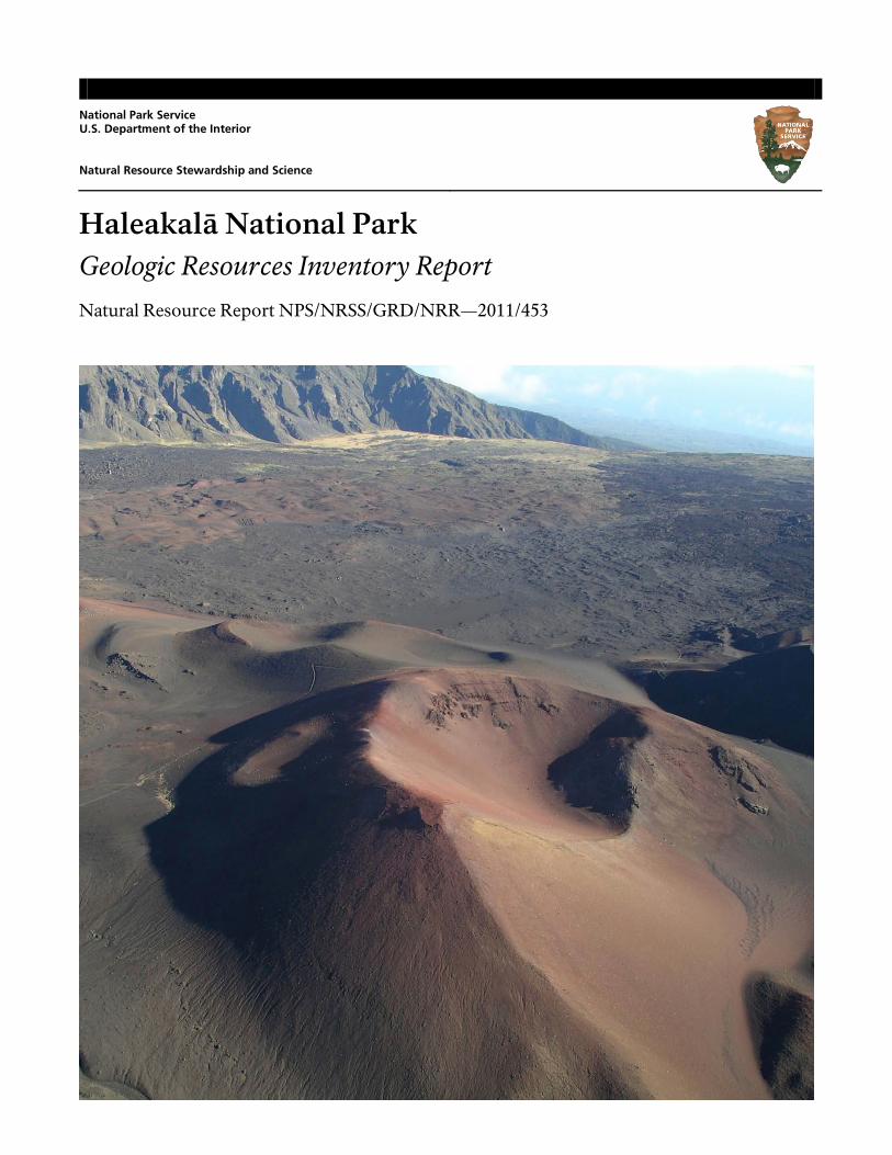
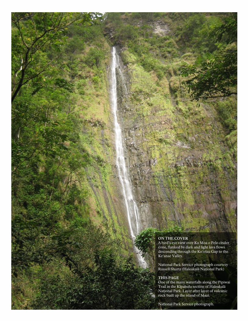
ON THE COVER A bird’s eye view over Ka Moa o Pele cinder cone, flanked by dark and light lava flows descending through the Ko‘olau Gap to the Ke‘anae Valley. National Park Service photograph courtesy Russell Shurtz (Haleakalā National Park) THIS PAGE One of the many waterfalls along the Pipiwai Trail in the Kīpahulu section of Haleakalā National Park. Layer after layer of volcanic rock built up the island of Maui. National Park Service photograph.

Haleakalā National Park Geologic Resources Inventory Report
Natural Resource Report NPS/NRSS/GRD/NRR—2011/453
National Park Service Geologic Resources Division PO Box 25287 Denver, CO 80225
September 2011
U.S. Department of the Interior National Park Service Natural Resource Stewardship and Science Fort Collins, Colorado
ii NPS Geologic Resources Division
The National Park Service, Natural Resource Stewardship and Science office in Fort Collins, Colorado publishes a range of reports that address natural resource topics of interest and applicability to a broad audience in the National Park Service and others in natural resource management, including scientists, conservation and environmental constituencies, and the public.
The Natural Resource Report Series is used to disseminate high-priority, current natural resource management information with managerial application. The series targets a general, diverse audience, and may contain NPS policy considerations or address sensitive issues of management applicability.
All manuscripts in the series receive the appropriate level of peer review to ensure that the information is scientifically credible, technically accurate, appropriately written for the intended audience, and designed and published in a professional manner. This report received informal peer review by subject-matter experts who were not directly involved in the collection, analysis, or reporting of the data.
Views, statements, findings, conclusions, recommendations, and data in this report do not necessarily reflect views and policies of the National Park Service, U.S. Department of the Interior. Mention of trade names or commercial products does not constitute endorsement or recommendation for use by the U.S. Government.
Printed copies of this report are produced in a limited quantity and they are only available as long as the supply lasts. This report is available from the Geologic Resources Inventory website (http://www.nature.nps.gov/geology/inventory/ gre_publications.cfm) and the Natural Resource Publications Management website (http://www.nature.nps.gov/publications/nrpm/).
Please cite this publication as:
Thornberry-Ehrlich, T. 2011. Haleakalā National Park: geologic resources inventory report. Natural Resource Report NPS/ NRSS/GRD/NRR—2011/453. National Park Service, Ft. Collins, Colorado.
NPS 162/110519, September 2011
HALE Geologic Resources Inventory Report iii
Contents
List of Figures ................................................................................................................ iv
Executive Summary ....................................................................................................... v
Acknowledgements ...................................................................................................... vi Credits ........................................................................................................................................................................ vi
Introduction ................................................................................................................... 1 Purpose of the Geologic Resources Inventory ............................................................................................................... 1 Park Setting ................................................................................................................................................................. 1
Geologic Issues .............................................................................................................. 7 Wind and Water Erosion and Mass Wasting ................................................................................................................. 7 Coastal Erosion and Relative Sea Level Rise ................................................................................................................... 7 Volcanic Activity and Hazards ....................................................................................................................................... 8 Seismic Activity and Tsunamis ...................................................................................................................................... 9
Geologic Features and Processes ................................................................................ 13 Haleakalā Volcano ..................................................................................................................................................... 13 Paleomagnetic Record ................................................................................................................................................ 14 Pleistocene Glaciation ................................................................................................................................................ 14 Geology and Early Settlement .................................................................................................................................... 14 Geology and Biology Connections .............................................................................................................................. 15 Martian Comparisons ................................................................................................................................................. 16 Geothermal Resource Potential .................................................................................................................................. 16
Geologic History .......................................................................................................... 21 Pre-Quaternary History of the Pacific Basin ................................................................................................................. 21 Evolution of the Hawaiian-Emperor Seamount Chain .................................................................................................. 21
Geologic Map Data ...................................................................................................... 31 Geologic Maps ........................................................................................................................................................... 31 Source Maps .............................................................................................................................................................. 31 Geologic GIS Data ...................................................................................................................................................... 31 Geologic Map Overview ............................................................................................................................................. 32 Map Unit Properties Table .......................................................................................................................................... 32 Use Constraints .......................................................................................................................................................... 32
Geologic Map Overview Graphic ................................................................................ 33
Map Unit Properties Table .......................................................................................... 35
Glossary ........................................................................................................................ 39
Literature Cited ............................................................................................................ 41
Additional References ................................................................................................. 46 Geology of National Park Service Areas ...................................................................................................................... 46 Resource Management/Legislation Documents ........................................................................................................... 46 Geological Survey Websites ........................................................................................................................................ 46 Other Geology/Resource Management Tools .............................................................................................................. 46
Appendix: Scoping Session Participants .................................................................... 47
Attachment 1: Geologic Resources Inventory Products CD
iv NPS Geologic Resources Division
List of Figures
Figure 1. Panoramic view of the Island of Maui ............................................................................................................ 3 Figure 2. Maps of Haleakalā National Park ................................................................................................................... 4 Figure 3. Summit view ................................................................................................................................................. 5 Figure 4. Relief imagery of the northern Pacific Ocean basin ......................................................................................... 5 Figure 5. Landslides on Maui ...................................................................................................................................... 10 Figure 6. The hydrologic cycle of Maui ....................................................................................................................... 11 Figure 7. Earthquake hazard zones for the major Hawaiian Islands.............................................................................. 11 Figure 8. Photograph of the crater at Haleakalā Volcano ............................................................................................ 17 Figure 9. Generalized geology map of Maui ............................................................................................................... 18 Figure 10. Map of the Loa and Kea Trend volcanoes ................................................................................................... 18 Figure 11. Silversword ................................................................................................................................................ 19 Figure 12. Geologic time scale.................................................................................................................................... 25 Figure 13. Cenozoic time scale of events affecting the Hawaiian Islands ...................................................................... 26 Figure 14. Plates in the past ....................................................................................................................................... 26 Figure 15. Map of the current tectonic plates ............................................................................................................. 27 Figure 16. Tectonic setting of the Pacific Plate ............................................................................................................ 27 Figure 17. Simplified stages of Hawaiian hotspot island volcanism .............................................................................. 28 Figure 18. Ages of shield-stage volcanism .................................................................................................................. 28 Figure 19. Bathymetric map of Maui .......................................................................................................................... 29 Figure 20. Lava flow distribution of the Hāna Volcanics .............................................................................................. 29
HALE Geologic Resources Inventory Report v
Executive Summary
This report accompanies the digital geologic map data for Haleakalā National Park in Hawaii, produced by the Geologic Resources Division in collaboration with its partners. It contains information relevant to resource management and scientific research. This document incorporates preexisting geologic information and does not include new data or additional fieldwork. Haleakalā means “House of the Sun” in Hawaiian. The landscape at Haleakalā National Park, on the island of Maui, may have contributed to early Hawaiians reverence of this place. The geology of the park forms the foundation for rare ecosystems and provides many research opportunities. The park strives to protect and preserve the unique environment of Haleakalā, while educating and providing access to more than one million visitors each year. Understanding geology contributes to the management of the scenic, natural, and cultural resources of the park. Geology influences groundwater flow and affects climate, weather, hydrology, and topography, which in turn affect coral reefs and other submarine habitats. Geology had a strong influence in the history at the park. Geologic issues of particular significance for resource management at Haleakalā National Park were identified during a scoping meeting in March 2003 and include:
• Wind and water erosion. The prevailing force driving erosion on Haleakalā Volcano changes with geographical location. The leeward (south and west) sides of the volcano, as well as higher elevations, are subject to wind-driven erosion. High precipitation rates and moisture carve the windward (north and east) sides of the volcano. Changes in native vegetation and anthropogenic developments increase the amount of fine-grained, unconsolidated sediment available to prevailing winds and flowing water. Increased sediment loads may degrade the riparian environments and streams at Haleakalā. Fine particles often are deposited in the coastal waters near the park. This increased sedimentation and turbidity affect the submarine environment as well.
• Coastal Erosion and Relative Sea Level Rise. Coastal erosion and relative sea level rise affect the shoreline at the park, potentially leading to loss of natural and cultural resources. Coastal erosion is a function of numerous factors. Relative sea level rise is locally lower on Maui than on the Island of Hawai‘i. This difference is a function of volcanic activity, weathering, and crustal loading.
• Volcanic Activity and Hazards. Haleakalā Volcano crowns Haleakalā National Park. This volcano is considered potentially active, having erupted frequently during the past thousands of years. The most recent eruption was about 400 years ago. Volcanic hazards include lava flow inundation, pyroclastic ejecta, noxious gases (including “vog”), and lava tube collapse.
• Seismic Activity and Tsunamis. Seismic activity is a concern throughout the Pacific basin. Earthquakes occur as a result of magma movement accompanying volcanism, as well as crustal stresses arising from areas of structural weakness and crustal loading by the volcanic mass. Earthquakes can cause fatalities, ground rupture, trigger tsunamis, localized deformation and damage to roads, buildings, and homes. The coastal areas of Haleakalā are especially susceptible to inundation during tsunamis.
The scenic and cultural resources of the park are closely linked to its geologic features and processes. This theme is a potential interpretive topic. Haleakalā Volcano itself is the primary geologic feature of the park. The eroded crater area provides an opportunity to study the volcanic evolution of a Hawaiian Island. Other features and processes of interest at Haleakalā National Park include a remarkable record of paleomagnetism, possible glaciations during the Pleistocene, comparison with Martian features and processes, and connections between biology and early Hawaiian history. Knowledge of the physical properties of the different geologic units mapped at Haleakalā National Park contributes to understanding and managing the natural and cultural resources throughout the park. The Map Unit Properties Table highlights the geologic issues, features, and processes associated with each map unit as well as the geologic history and connections to park stories for each geologic unit. In addition to their physical properties, the rock units at Haleakalā National Park contain information related to volcanic island evolution and the geologic history of the Hawaiian-Emperor seamount chain in the Pacific Ocean basin. The glossary contains explanations of many technical terms used in this report, including terms used in the Map Unit Properties Table. A geologic timescale is provided as figures 12 and 13.
vi NPS Geologic Resources Division
Acknowledgements
The Geologic Resources Inventory (GRI) is one of 12 inventories funded by the National Park Service Inventory and Monitoring Program. The GRI is administered by the Geologic Resources Division of the Natural Resource Stewardship and Science Directorate. The Geologic Resources Division relies heavily on partnerships with institutions such as the U.S. Geological Survey, Colorado State University, state geologic surveys, local museums, and universities in developing GRI products. Special thanks to: Dave Sherrod (U.S. Geological Survey) reviewed the Hawaii Volcanoes National Park report. Applicable comments and suggestions from that report were incorporated here. Stephen Anderson (Haleakalā National Park) coordinated park review of the report. Russell Shurtz (Haleakalā National Park) provided photos of the park used in the report.
Credits
Author
Trista L. Thornberry-Ehrlich (Colorado State University)
Review
Frank Trusdell (U.S. Geological Survey) Matt Brown (Haleakalā National Park) Elizabeth Gordon (Haleakalā National Park) Philip Reiker (NPS Geologic Resources Division)
Editing
Steve Hoffman (Write Science Right)
Digital Geologic Data Production
Greg Mack (NPS Pacific West Region) Ron Karpilo (Colorado State University)
Digital Geologic Data Overview Layout Design
Derek Witt (Colorado State University) Philip Reiker (NPS Geologic Resources Division)
HALE Geologic Resources Inventory Report 1
Introduction
The following section briefly describes the National Park Service Geologic Resources Inventory and the regional geologic setting of Haleakalā National Park. Purpose of the Geologic Resources Inventory
The Geologic Resources Inventory (GRI) is one of 12 inventories funded by the National Park Service (NPS) Inventory and Monitoring Program. The GRI, administered by the Geologic Resources Division of the Natural Resource Stewardship and Science Directorate, is designed to provide and enhance baseline information available to park managers. The GRI team relies heavily on partnerships with institutions such as the U.S. Geological Survey, Colorado State University, state geologic surveys, local museums, and universities in developing GRI products. The goals of the GRI are to increase understanding of the geologic processes at work in parks and to provide sound geologic information for use in park decision making. Sound park stewardship requires an understanding of the natural resources and their role in the ecosystem. Park ecosystems are fundamentally shaped by geology. The compilation and use of natural resource information by park managers is called for in section 204 of the National Parks Omnibus Management Act of 1998 and in NPS-75, Natural Resources Inventory and Monitoring Guideline. To realize these goals, the GRI team is systematically conducting a scoping meeting for each of the 270 identified natural area parks and providing a park-specific digital geologic map and geologic report. These products support the stewardship of park resources and are designed for nongeoscientists. Scoping meetings bring together park staff and geologic experts to review available geologic maps and discuss specific geologic issues, features, and processes. The GRI mapping team converts the geologic maps identified for park use at the scoping meeting into digital geologic data in accordance with their Geographic Information Systems (GIS) Data Model. These digital data sets bring an interactive dimension to traditional paper maps. The digital data sets provide geologic data for use in park GIS and facilitate the incorporation of geologic considerations into a wide range of resource management applications. The newest maps contain interactive help files. This geologic report assists park managers in the use of the map and provides an overview of park geology and geologic resource management issues. For additional information regarding the content of this report and current GRI contact information please refer to the Geologic Resources Inventory website (http://www.nature.nps.gov/geology/inventory/).
Park Setting
Regional Information
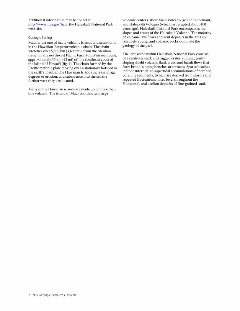
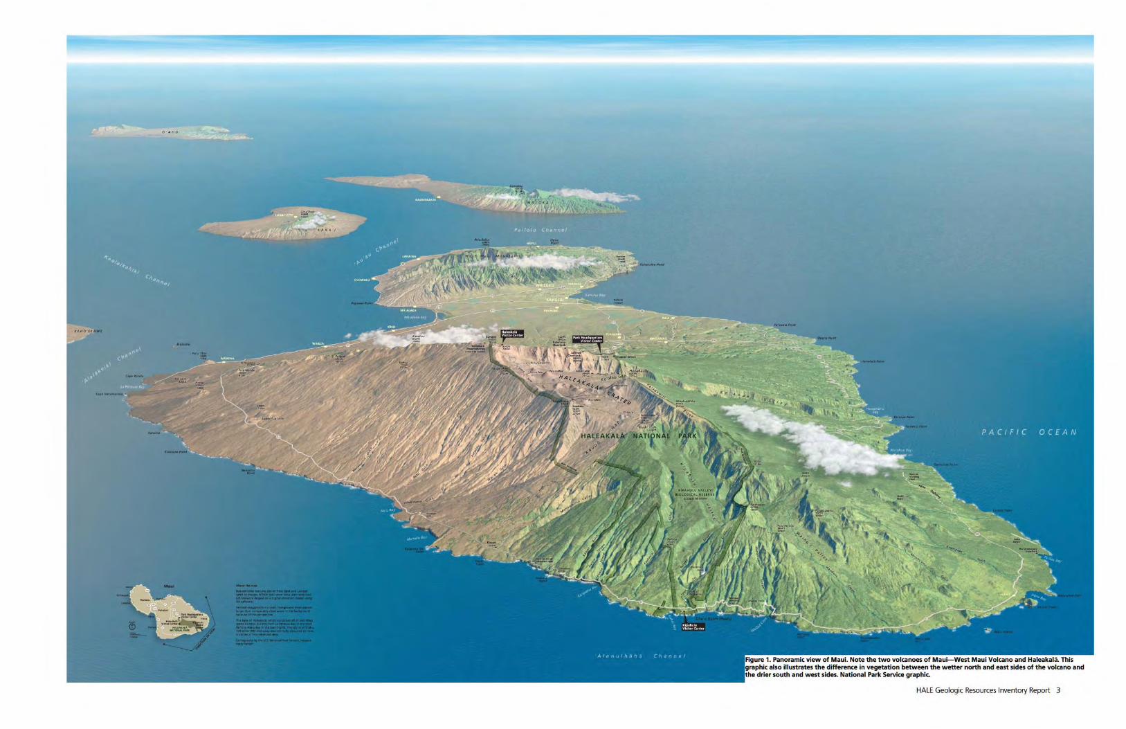
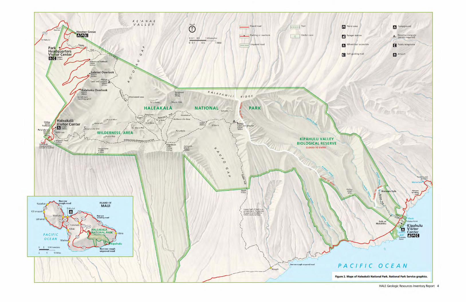
Haleakalā National Park encompasses 134 sq km (33,223 ac) of the southeastern side of the island of Maui (figs. 1 and 2). The island of Maui covers an area of about 1,884 sq km (727 sq mi) and is the second largest and second youngest of the seven main Hawaiian Islands. The Island of Hawai‘i lies southeast of Maui, separated by the 48-km-wide (30-mi) ‘Alenuihāhā Channel, and is the youngest landmass of the Hawaiian island chain. Haleakalā National Park preserves diverse ecosystems, including tropical rainforest on the windward north and eastern slopes, arid desert on the leeward western slopes, and subalpine to alpine environments at higher elevation. Each ecosystem hosts collections of flora and fauna uniquely suited to that area; ancient Hawaiians found ways to use every environment as they inhabited the island. The island contains two primary volcanic masses, Haleakalā (East Maui Volcano) and the West Maui Volcano. The highest point is the Pu‘u‘ula‘ula summit atop Haleakalā Volcano at with an elevation of 3,055 m (10,023 ft). The two volcanic centers are connected by a broad, sweeping lowland between them (figs. 1 and 3).
Cultural History and Establishment of Haleakalā National Park
The earliest human inhabitants took advantage of the varied environment, and evidence of their presence dots the landscape at Haleakalā National Park. As early as C.E. 1200, Hawaiians were using areas at the summit of Haleakalā Volcano (Carson and Mintmier 2006). These early inhabitants left archaeological features on the landscape, such as dry-stone shelters, workshops for tool making, heiau and shrines, and rock art. Ritual sites were an integral part of an advanced religious society. Facets of this religion were defined in the kapu (laws of conduct). In old Hawaii, kapu governed all aspects of society. After 1819, Hawaiians discontinued the kapu system and old religions of Hawaii. Haleakalā National Park strives to preserve and protect the cultural resources within the park and support the perpetuation of related cultural practices, as appropriate. Haleakalā National Park was established on August 1, 1916, originally as part of Hawaii National Park. It was separated and renamed on September 13, 1960, with subsequent boundary changes. Its wilderness was designated on October 20, 1976, and the park was designated a Biosphere Reserve in 1980. It preserves a variety of landforms, from seashores to the volcanic summits, while protecting native Hawaiian ecosystems and cultural sites.
2 NPS Geologic Resources Division
Additional information may be found at http://www.nps.gov/hale, the Haleakalā National Park web site.
Geologic Setting
Maui is just one of many volcanic islands and seamounts in the Hawaiian-Emperor volcanic chain. The chain stretches over 5,800 km (3,600 mi), from the Aleutian trench in the northwest Pacific basin to Lō‘ihi seamount, approximately 35 km (22 mi) off the southeast coast of the Island of Hawai‘i (fig. 4). The chain formed by the Pacific tectonic plate moving over a stationary hotspot in the earth’s mantle. The Hawaiian Islands increase in age, degrees of erosion, and subsidence into the sea the further west they are located. Many of the Hawaiian islands are made up of more than one volcano. The island of Maui contains two large
volcanic centers: West Maui Volcano (which is dormant) and Haleakalā Volcano (which last erupted about 400 years ago). Haleakalā National Park encompasses the slopes and crater of the Haleakalā Volcano. The majority of volcanic lava flows and vent deposits in the area are relatively young, and volcanic rocks dominate the geology of the park. The landscape within Haleakalā National Park consists of a relatively stark and rugged crater, summit, gently sloping shield volcanic flank areas, and basalt flows that form broad, sloping benches or terraces. Sparse beaches include intertidal to supertidal accumulations of perched coralline sediments, (which are derived from storms and repeated fluctuations in sea level throughout the Holocene), and aeolian deposits of fine-grained sand.
HALE Geologic Resources Inventory Report 5
Figure 3. Summit view. Photograph from near the summit of Haleakalā Volcano, looking towards West Maui Volcano across a broad saddle. Photograph by Trista L. Thornberry-Ehrlich (Colorado State University).
Figure 4. Relief imagery of the northern Pacific Ocean basin. The Hawaiian-Emperor volcanic chain and other relatively shallow areas are visible as lighter blue areas. The inset box labels the major Hawaiian Islands and National Park Service areas (smaller areas represented by red stars). KALA: Kalaupapa National Historical Park (NHP); HALE: Haleakalā National Park (NP); PUHE: Pu‘ukoholā Heiau National Historic Site (NHS); PUHO: Pu‘uhonua o Hōnaunau NHP; KAHO: Kaloko-Honokōhau NHP; HAVO: Hawai‘i Volcanoes NP. The arrow indicates present motion of the Pacific plate at 95 mm/year (3.74 inches/year). Compiled by Philip Reiker (NPS Geologic Resources Division) from Natural Earth imagery, with information from Eakins et al. (2003). Map of Hawaiian Islands from the Hawaiian Multibeam Bathymetry Synthesis project, available online: http://www.soest.hawaii.edu/HMRG/Multibeam/index.php accessed September 19, 2011, annotated by Jason Kenworthy (NPS Geologic Resources Division).

HALE Geologic Resources Inventory Report 7
Geologic Issues
The Geologic Resources Division held a Geologic Resources Inventory scoping session for Haleakalā National Park on March 20-21, 2003, to discuss geologic resources, address the status of geologic mapping, and assess resource management issues and needs. This section synthesizes the scoping results, in particular those issues that may require attention from resource managers. Contact the Geologic Resources Division for technical assistance. The primary resource management emphasis at Haleakalā National Park is the preservation and protection of the incredible variety of ecosystems on the volcano’s flanks. Management goals include reducing the impact of park activities on the environment, while providing educational visitor access and cultural resource preservation. Hawaii is the only state in the U.S. that is subject to earthquakes, volcanism, tsunamis and hurricanes. The dynamic geomorphic processes at work on the Hawaiian landscape, including coastal erosion, sea level rise, seasonal high waves, and stream erosion (Richmond et al. 2001), increases the utility of knowledge of the physical world underlying the park’s ecosystems. Rutherford and Kaye (2006) provide an overview of resource management issues facing Haleakalā National Park, including a comprehensive list of original sources. The reader is encouraged to obtain this resource for reference.
Wind and Water Erosion and Mass Wasting
Wind erosion is a major resource management concern at Haleakalā National Park. Wind erosion transports a consistent supply of fine-grained sediment to park lands. Erosion can also lead to increased sedimentation and turbidity within the offshore submarine environment, which can block sunlight, required by the living reefs (Rutherford and Kaye 2006). In the arid portions of the park (high elevation areas and the leeward flanks), land use practices can increase the amount of sediment available to prevailing winds. Once disturbed, stabilizing vegetation is slow to reestablish itself. On the windward, moisture-laden side of the island, flowing water is the primary erosive force. Erosion there has been exacerbated by anthropogenic changes to the landscape, including introduction of feral ungulates and invasive plant species (Rutherford and Kaye 2006). Here, erosion is a significant issue, because scoured stream banks lead to degraded riparian habitats. Increases in sediment load and turbidity in the marine environment adversely affect ecosystem productivity, soil health, and aquatic flora and fauna (Rutherford and Kaye 2006). Steep slopes within the park are prone to mass wasting. Mass wasting refers to the dislodging and downslope movement of soil and rock material. Mass wasting at Haleakalā National Park is manifested as landslides (fig. 5), mud flows, or soil creep. Mass wasting tends to result
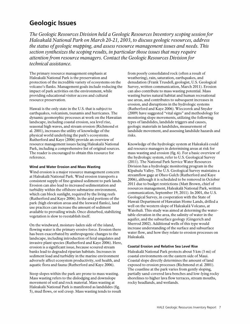
from poorly consolidated rock (often a result of weathering), rain, saturation, earthquakes, and denudation (Frank Trusdell, geologist, U.S. Geological Survey, written communication, March 2011). Erosion can also contribute to mass wasting potential. Mass wasting buries natural habitat and human recreational use areas, and contributes to subsequent increases in erosion, and disruptions in the hydrologic systems (Rutherford and Kaye 2006). Wieczorek and Snyder (2009) have suggested “vital signs” and methodology for monitoring slope movements, utilizing the following: types of landslides, landslide triggers and causes, geologic materials in landslides, measurement of landslide movement, and assessing landslide hazards and risks. Knowledge of the hydrologic system at Haleakalā could aid resource managers in determining areas at risk for mass wasting and erosion (fig. 6). For a basic overview of the hydrologic system, refer to U.S. Geological Survey (2011). The National Park Service Water Resources Division has a hydrologic monitoring program in the Kīpahulu Valley. The U.S. Geological Survey maintains a streamflow gage at Oheo Gulch (Rutherford and Kaye 2006), although it is scheduled to be removed in October 2011 due to budget restrictions (Matt Brown, chief of resources management, Haleakalā National Park, written communication, September 19, 2011). In 2001, the U.S. Geological Survey, in cooperation with the State of Hawaii Department of Hawaiian Home Lands, drilled a well on the western slope of Haleakalā Volcano, at Waiohuli. This study was aimed at determing the water-table elevation in the area, the salinity of water in the aquifer, and the subsurface geology (Gingerich and Sherrod 2002). Additional wells of this type would increase understanding of the surface and subsurface water flow, and how they relate to erosion processes on Haleakalā.
Coastal Erosion and Relative Sea Level Rise
Haleakalā National Park protects about 5 km (3 mi) of coastal environments on the eastern side of Maui. Coastal slope directly determines the amount of land exposed to erosion processes (Richmond et al. 2001). The coastline at the park varies from gently sloping, partially sand-covered lava benches and low-lying rocky shorelines to higher lava flow terraces, stream mouths, rocky headlands, and wetlands.

8 NPS Geologic Resources Division
Coastal erosion can lead to instability of lava benches, inundation, damage to shallow coral reefs, and increased sediment load in the near shore, all of which can impact natural and cultural resources. Average erosion rates in Hawaii are approximately 15-30 cm/yr (0.5-1 ft/yr) (Richmond et al. 2001). Many factors are involved in coastal evolution and erosion vulnerability, including tidal range, wave height, coastal slope, geomorphology, and relative sea level change. Tidal range and wave height are linked to inundation hazards (Rutherford and Kaye 2006). Tsunamis, a significant hazard in the Hawaiian Islands, can cause erosion along the coastline, damage to reefs, and saltwater incursion to near shore habitats in a single erosive event. See the “Seismic Activity and Tsunamis” section for more information. The leeward coast of Maui is relatively sheltered from the high wave energies found elsewhere in the state. However, when deep-water ocean swells encounter a shallow area, such as an island margin or seamount, they can rise to great heights. In the Hawaiian Islands, this effect is exacerbated because the contact between deep water and the shallow margins is especially abrupt. Surface waves can quickly grow very tall over a short distance. Swell effects vary seasonally. Sudden high waves and seasonal swells are among the most consistent and predictable coastal hazards of Maui (Richmond et al. 2001). Among the other factors involved in coastal evolution and vulnerability to erosion is coastal slope, or the steepness of the coastal region. This is directly linked to inundation and to the rates of shoreline advance or retreat. Geomorphology influences the relative erodability of a specific section of shoreline. Relative sea level changes correspond to global (eustatic) sea level fluctuations and local vertical land motion (uplift or subsidence). On average, the rate of relative sea level rise is 2.54 mm/yr (1 in./decade) for Maui, and the loading effect lessens with distance from the active volcanism on the Islandof Hawai‘i (Richmond et al. 2001). Not all sea-level rise is caused by natural processes. Particularly through the emission of greenhouse gases, human activity is—with more than 90% certainty (IPCC 2007)—contributing to global warming, and thus accelerating the rate of climate change and global sea level rise. Karl et al. (2009) summarized climate change impacts for Hawaii and other U.S.-affiliated islands. Along with increases in air and ocean surface temperatures, the number of heavy rain events is very likely to increase, particularly during the summer months (winter is the normal rainy season). Peak cyclone winds, precipitation, and associated storm surges are also projected to increase. Sea level rise projections vary widely depending on location and future emissions scenarios. Globally, at least 0.18 m to 0.59 m (7 in. to 2 ft) of sea level rise is projected by 2100 (Meehl et al. 2007). For low-lying coastal areas in Haleakalā National Park, sea level rise may cause saltwater incursion into freshwater aquifers and coastal inundation (Karl et al. 2009; Rutherford and Kaye 2006).
Bush and Young (2009) suggested methodologies for monitoring coastal features and processes, using seven “vital signs”: shoreline change, coastal dune morphology, coastal vegetation cover, topography/elevation, composition of beach material, wetland position/acreage, and coastal wetland accretion. Not all of these vital signs are applicable to Haleakalā National Park.
Volcanic Activity and Hazards
Haleakalā National Park contains the only potentially active Hawaiian volcano not on the Island of Hawai‘i (Sherrod et al. 2007). Volcanic activity (volcanism) recurs on a 200-500 year interval, with the most recent eruption about 400 years ago, around C.E. 1600. Hence, volcanism is a very real possibility at the park. Several issues associated with active volcanism are the eruption and destruction associated with flows, pyroclastic ejecta, corrosive volcanic gases, and subsurface thermal heating. Flows from Hawaiian volcanoes can reach distances of 50 km (30 mi) or more. Lava flows commonly follow a predictable path controlled by slope and topography. Thick, viscous ‘a‘ā flows tend to bulldoze, crush, bury, and burn anything in the flow path, whereas more fluid pāhoehoe lava tends to flow around obstacles. Individual flows are generally less than 5 m (16 ft) thick, however younger flows cover older flows, forming thick deposits of lava on the landscape. While basaltic lava generally flows slowly enough to allow people and animals to escape, immobile objects in the path of a flow, such as vegetation, historical and cultural sites, or modern development, will be damaged or destroyed by burial, crushing, or ignition (Rutherford and Kaye 2006). The ejection of pyroclastic materials from cinder or spatter cones can similarly damage or destroy resources, but the spatial extent of the effect is limited to near-vent areas. The largest pyroclastic materials tend to fall close to the vent building cones. Areas as much as 8 km (5 mi) from an active vent could be affected by falling cinders and ash, as well as toxic gases (Crandell 1983). Volcanic activity is usually preceded and accompanied by seismic activity and rock deformation, as well as the appearance of cracks in the ground (Crandell 1983). Cracks can produce depressions or grabens several meters deep and wide (Kubacki et al. 1984). Volcanism also triggers variations in the geophysical state and gas chemistry state of the volcanic system. The U.S. Geological Survey’s Hawaiian Volcano Observatory (HVO, near the summit of Kīlauea) has an extensive monitoring system for the islands of Hawai‘i and Maui, monitoring lava flows, deformation, seismicity and volcanic emissions. Every two years, HVO conducts GPS and dry tilt surveys at Haleakalā National Park (Rutherford and Kaye 2006). This monitoring provides a base for comparison and an invaluable record of ground deformation patterns associated with volcanism. In 2006, geologists mapped areas at high risk for lava inundation if volcanism were to recur at Haleakalā National Park (Sherrod et al. 2006). Areas most likely to be inundated
HALE Geologic Resources Inventory Report 9
by lava include those near rift zones, downslope areas within the lava sheds (analogous to watersheds) of rift zones, and areas where lava is channeled by topographic features. Topographic obstructions define areas at low risk of being inundated by lava flows. On Haleakalā Volcano, hazardous zones generally follow the symmetry of the southwest and eastern rift zones. There are a few exceptional high areas lying between canyons carved into the east rift zone. Haleakalā’s summit crater serves as a topographic trap of lava flows (Sherrod et al. 2006). Another potential issue associated with volcanism in the vicinity of Haleakalā National Park is airborne volcanic emissions from active volcanoes on the Island of Hawai‘i. According to the U.S. Geological Survey HVO, Kīlauea Volcano emits hundreds of tons of toxic sulfur dioxide gas (SO2) each day, making it among the largest stationary sources of SO2 in the United States. Sulfur dioxide, combined with acid aerosols and fine particulates, creates a haze known as “vog”. Depending on wind conditions, vog from the active Kīlauea volcano can partially obscure the landscape of Haleakalā National Park. Vog would certainly become more of an issue if Haleakalā Volcano began erupting again. During particularly active eruptive periods, and in the absence of prevailing winds, vog can stretch beyond Maui, as far away as O‘ahu, some 350 km (220 mi) northwest of Kīlauea. At greater distances, the vog tends to thin out. Volcanic emissions of carbon dioxide, sulfur dioxide, and hydrochloric acid can destroy surrounding vegetation. These emissions are directly responsible for acidification of soils, and relative enrichment of heavy metals in soils and surface water (Rutherford and Kaye 2006). There are also human health issues regarding exposure to volcanic gasses. In cooperation with the U.S. Geological Survey, the National Park Service Air Resources Division maintains air quality monitors on Kīlauea. Real time data is available online: http://www.nature.nps.gov/air/WebCams/parks/ havocam/havocam.cfm. Smith et al. (2009) have suggested “vital signs” and monitoring methodology for volcanoes utilizing earthquake activity, ground deformation, emission at ground level, emission of gas plume and ash clouds, hydrologic activity, and slope instability. Many of the examples used by Smith et al. (2009) come from U.S. Geological Survey HVO’s monitoring of volcanoes in Hawai‘i Volcanoes National Park.
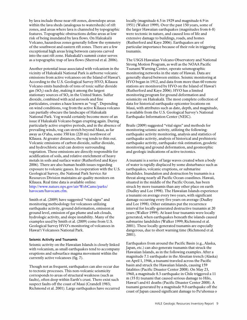
Seismic Activity and Tsunamis
Seismic activity on the Hawaiian Islands is closely linked with volcanism, as small earthquakes tend to accompany eruptions and subsurface magma movement within the currently active volcanoes (fig. 7). Though not as frequent, earthquakes can also occur due to tectonic processes. This non-volcanic seismicity corresponds to areas of structural weakness (such as faults), often deep within Earth’s crust. There exist such suspect faults off the coast of Maui (Crandell 1983; Richmond et al. 2001). Large earthquakes have occurred
locally (magnitude 6.5 in 1929 and magnitude 6.9 in 1951) (Walker 1999). Over the past 150 years, some of the larger Hawaiian earthquakes (magnitudes from 6-8) were tectonic in nature, and caused loss of life and extensive damage to buildings, roads, and homes (Rutherford and Kaye 2006). Earthquakes are of particular importance because of their role in triggering tsunamis. The USGS Hawaiian Volcano Observatory and National Strong Motion Program, as well as the NOAA Pacific Tsunami Warning Center, operate seismographic monitoring networks in the state of Hawaii. Data are generally shared between entities. Seismic monitoring at HVO began in 1912, and data from more than 60 remote stations are monitored by HVO on the Island of Hawai‘i (Rutherford and Kaye 2006). HVO has a limited monitoring program for ground deformation and seismicity on Haleakalā. The most complete collection of data for historical earthquake epicenter locations on Maui, with attributes such as date, depth, and magnitude, is available from the U.S. Geological Survey’s National Earthquake Information Center (NEIC). Braile (2009) suggested “vital signs” and methods for monitoring seismic activity, utilizing the following: earthquake activity monitoring, analysis and statistics of earthquake activity, analysis of historical and prehistoric earthquake activity, earthquake risk estimation, geodetic monitoring and ground deformation, and geomorphic and geologic indications of active tectonics. A tsunami is a series of large waves created when a body of water is rapidly displaced by some disturbance such as earthquakes, volcanic eruptions, or submarine landslides. Inundation and destruction by tsunamis is a threat along nearly all Pacific Ocean coastlines. Hawaii, situated in the middle of the Pacific Ocean, has been struck by more tsunamis than any other place on earth (Dudley and Lee 1998). The Hawaiian Islands experience a tsunami on average every two years, with significant damage occurring every five years on average (Dudley and Lee 1998). Other estimates put the recurrence interval for locally-generated destructive tsunamis at 20 years (Walker 1999). At least four tsunamis were locally generated, when earthquakes beneath the islands caused submarine landslides (Walker 1999; Richmond et al. 2001). These locally-generated tsunamis are especially dangerous, due to short warning time (Richmond et al. 2001). Earthquakes from around the Pacific Basin (e.g., Alaska, Japan, etc.) can also generate tsunamis that struck the Hawaiian Islands, as in the following examples. After a magnitude 7.1 earthquake in the Aleutian trench (Alaska) on April 1, 1946, a tsunami traveled across the Pacific basin and struck the Hawaiian Islands, causing 159 fatalities (Pacific Disaster Center 2008). On May 23, 1960, a magnitude 8.3 earthquake in Chile triggered a 11 m (35 ft) tsunami that caused serious damage to Hilo, Hawai‘i and 61 deaths (Pacific Disaster Center 2008). A tsunami generated by a magnitude 9.0 earthquake off the coast of Japan caused significant damage to Pu‘uhonua o

10 NPS Geologic Resources Division
Hōnaunau and Kaloko-Honokōhau national historical parks (on the Island of Hawai‘i) on March 11, 2011 (National Park Service 2011). In addition to loss of life and threats to infrastructure, tsunamis can cause erosion along the coastline, destroy shoreline cultural resources, damage coral reefs, and inundate nearshore habitats and aquifers with saltwater (Rutherford and Kaye 2006). There has been widespread development along the Hawaiian shoreline since the 1960s which seems undeterred by the potential danger of inundation by tsunamis (Richmond et al. 2001). Walker (2004) uses historical runup data (a measurement of the height of the water onshore, observed above a reference sea level) for each Hawaiian Island to delineate tsunami evacuation feasibility; also modeled are tsunamis originating from various points throughout the Pacific. The Pacific Tsunami Warning Center (PTWC) (http://www.weather.gov/ptwc/) in Ewa Beach (O‘ahu) provides most countries in the Pacific Basin with tsunami warnings. This international program requires the cooperation of many seismic, tide, and communication
facilities, operated by most of the nations bordering the Pacific Ocean. Their operational objective is to detect and locate significant seismic events in the Pacific region, determine whether a tsunami was generated by the event, and minimize risk to the population by providing warnings and tsunami information. Seismic activity and ocean surface levels of the Pacific Basin are constantly monitored (Rutherford and Kaye 2006). As part of its operations, the Tsunami Warning System (TWS) continuously monitors the seismic activity and the ocean within the Pacific Basin (Tsunami Warning Centre 2007). In addition, NOAA has completed modeling of tsunami inundation zones and compiled assessments. The University of Hawaii SOEST Institute of Geophysics has also developed a model that may be more applicable to tsunamis caused by local seismic events. The U.S. Geological Survey maintains a tsunami website as part of its Pacific Coastal and Marine Science Center (http://walrus.wr.usgs.gov/tsunami/basics.html).
Figure 5. Landslides on Maui. Steep slopes contribute to mass wasting susceptibility, but slides such as the one above, mostly result from poorly consolidated rock (often a result of weathering), rain, saturation, earthquakes, and denudation. National Park Service photograph by Rebecca Beavers (NPS Geologic Resources Division).
HALE Geologic Resources Inventory Report 11
Figure 6. The hydrologic cycle of Maui. Note the role of lava flows in groundwater storage and impoundment. Graphic by Trista L. Thornberry-Ehrlich (Colorado State University), based on information by the U.S. Geological Survey (http://ga.water.usgs.gov/edu/watercycle.html).
Figure 7. Earthquake hazard zones for the major Hawaiian Islands. Seismic hazard potential decreases as distance from the active volcanoes on the Island of Hawai‘i increases. Graphic adapted by Trista L. Thornberry-Ehrlich (Colorado State University) from U.S. Geological Survey data (Klein et al. 2001, http://pubs.usgs.gov/imap/i-2724/).


HALE Geologic Resources Inventory Report 13
Geologic Features and Processes
This section describes the most prominent and distinctive geologic features and processes in Haleakalā National Park. Haleakalā Volcano
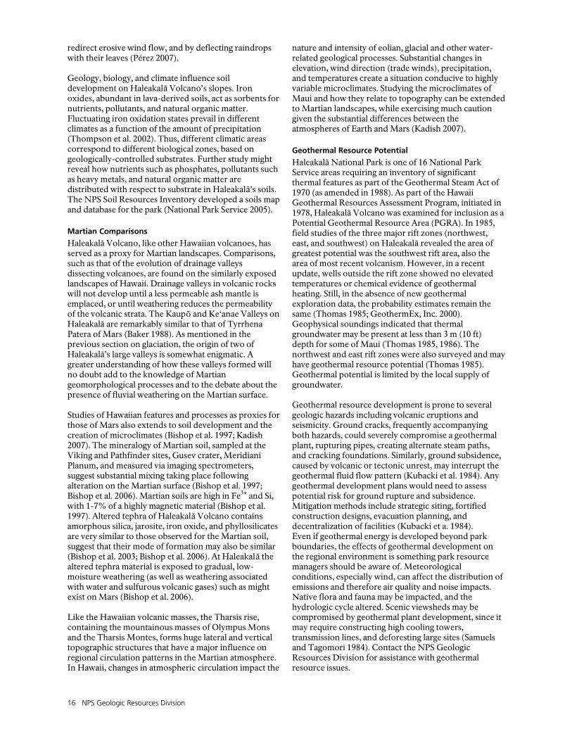
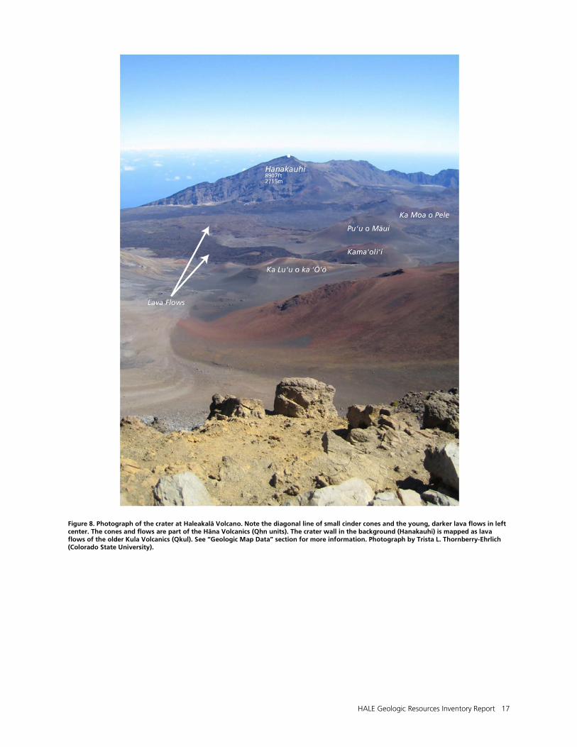
Haleakalā, or “House of the Sun,” rises 3055 m (10,023 ft) above sea level. It is the larger of the two volcanic masses that make up the island of Maui, the other being West Maui Volcano. Haleakalā Volcano, also known as East Maui Volcano, has a total volume of approximately 29,300 km3 (7,029 mi3) (Robinson and Eakins 2006). At its summit is a large erosional depression, more than 800 m (2,625 ft) deep. The “crater” is one of the largest erosional depressions on Earth (figs. 1 and 8) (Hackett 1988). The label “crater” is somewhat of a misnomer, since the feature actually formed via the erosion of two large drainages: Ke‘anae and Kaupō valleys (Hackett 1987). Erosion continued until the two valley heads merged through the Ko‘olau and Kaupō gaps, creating the single, vast, S-shaped depression (fig. 1) (Hacket 1987; Pérez 2003). Prior to widespread erosion, the summit possibly reached 600-900 m (2,000-3,000 ft) higher than its present point (Macdonald 1978). Structurally, Haleakalā has two major rift zones, extending outward from the summit to the east and southwest, with a third, smaller rift extending northwest (fig. 9) (Thomas 1985). Haleakalā Volcano is part of the Kea trend of volcanoes that includes West Maui, Mauna Kea, and Kohala volcanoes. The shield of East Moloka‘i volcano is the oldest volcano of the Kea trend. The Kea trend is parallel to the Loa trend (fig. 10). Lavas from within the same trend are geochemically similar. These geochemical characteristics reflect the source components associated with the Hawaiian hotspot, including the melting and postmelting processes that occur during the ascent of the magma into the volcano. Trace elements such as strontium (Sr), neodymium (Nd), and lead (Pb) are commonly used to delineate the two trends (Xu et al. 2005). Haleakalā is composed of interlayered pāhoehoe (lower viscosity) and ‘a‘ā (higher viscosity) lava flows, as well as thin tephra deposits as detailed on the Map Unit Properties Table (Gingerich and Sherrod 2002; Sherrod et al. 2007). Rocks within Haleakalā’s volcano clearly record a nearly complete sequence of Hawaiian volcanic evolution, from early shield building to late stage alkalic (eruptive materials richer in sodium and/or potassium) capping (Hackett 1987).Three major phases of eruptive activity produced the lava exposed on Haleakalā Volcano—the Honomanū, Kula, and Hāna phases. The Honomanū shield-building phase ended approximately 750,000 years ago (most ages date from 1.1 to 0.97 million years), the more alkalic (enriched in sodium and/or potassium) Kula phase followed for at least 250,000 years (age ranges from 930,000 to 150,000 years). The subsequent Hāna phase began about 120,000 years ago
and is considered potentially active today (fig. 9) (Thomas 1985; Sherrod et al. 2007). During the most recent period of volcanism, several post-shield lava flows and large cinder cones covered the crater floor (Sherrod 2007). Some of these cinder cones are up to 180 m (590 ft) high (West 1990) (fig. 8, cover). Haleakalā remains in the post-shield volcanic stage, not the classically-defined rejuvenated stage, as evidenced by the lack of a lengthy hiatus between the youngest Kula Volcanics at 150,000 years and the oldest Hāna Volcanics at 120,000 years (Sherrod 2002; Sherrod et al. 2007). Refer to the “Geologic History” section for more information. Some unusual volcanic rocks are exposed in the park. For example, a single dike of trachyte is exposed on the northwest wall of Haleakalā Crater. Other examples include an amphibole-bearing mugearite on the upper west wall of the crater, and several “bosses” of microdiorite along the northern and western crater walls (West 1990). A boss is a roughly circular (in map view) plutonic (intrusive) body with an areal extent of less than 100 km2 (40 mi2). North of the visitor center, on the western rim of Haleakalā Crater, the hawaiite lavas contain phenocrysts (crystals that formed in the magma prior to eruption) of the mineral hornblende, which is rare in Hawaiian lavas (Hackett 1987). At the aptly named Red Hill parking area, oxidized scoriaceous lapilli (small [2–64 mm, <2.5 in.] porous rock fragments that were ejected from the volcano) contain well-formed phenocrysts of the mineral augite. Many of the volcanic bombs retain their airborne shapes, resembling baseballs, ribbons, and almonds (Hackett 1987). Roadcuts near Crater Overlook display thick sections of lava that show the reversed stratigraphy of a magma chamber that underwent crystal settling. Here, rapid transitions between porphyritic (visible crystals) and aphyric (no visible crystals) basalt are easily seen. The basal layer of aphyric lava represents the first-erupted magma from the upper portion of the magma chamber (depleted in phenocrysts) at depth; the remainder of the flow contains lava layers with abundant crystals, including some dunite (olivine) fragments up to 4 cm (1.5 in.) in diameter. These are remnants of the olivine cumulate (collected crystals) that settled to the bottom of the magma chamber (Macdonald 1972; Hackett 1987). Haleakalā Volcano is considered potentially active (Sherrod et al. 2007). The Haleakalā satellite laser ranging facility (part of the Haleakalā Observatories) was used to measure changes in the volcano’s shape and height. The facility was assumed to be “stationary”; however, height measurements from 1981-1992 indicated the station rose in elevation, at a rate of 0.07 m/yr (0.23 ft/yr) (Jones 1995). This change in height could be due to inflation of the volcano by intrusion of

14 NPS Geologic Resources Division
hot magma. However, uplift could also be due to lithospheric flexure caused by loading Earth’s crust beneath the mass of volcanoes of the Island of Hawai‘i southeast of Haleakalā (Jones 1995). In other words, as Earth’s crust is loaded to the south by the growing volcanoes on Hawai‘i, surrounding areas are flexed upward, analogous to an archer drawing a bow.
Paleomagnetic Record
Geologists use paleomagnetic polarity measurements extensively in the study of lithospheric dynamics, geochronology, and stratigraphy (Coe et al. 2004). Upon cooling, magnetic minerals within the molten lava align with the Earth’s prevailing polarity. Within the rocks on Haleakalā, the magnetization record is prominent, and geologists use this record to date individual flows. Oriented drill core samples yield magnetic properties, including declination and inclination of the lava at the time of cooling (Sherrod et al. 2006). Paleomagnetic directions help correlate lava flows of similar age, and help constrain the ages for undated flows. This contributes to detailed stratigraphy and geologic mapping of the volcano, and furthers understanding of the evolution of Haleakalā Volcano (Sherrod et al. 2006). Polarity reversals are perhaps the most dramatic manifestation of the Earth’s magnetic field. Much like geologic time periods are given names (see figs. 12 and 13), the paleomagnetic record is divided into named periods of “normal” polarity (like today) or “reversed” polarity. Along the northwest wall of the Haleakalā caldera are 89 basaltic lava flows that preserve a paleomagnetic record of portions of the Matuyama-Brunhes reversal (about 780,000 years ago) and the preceding Kamikatsura event (about 900,000 years ago). This stratigraphic section provides the most detailed volcanic record of the transition on earth. There are 24 flows in the reversal transition zone that show transitional virtual geomagnetic poles (VGPs) that change from reverse to normal along the Americas, then conclude with an oscillation in the Pacific Ocean to a cluster of VGPs located east of New Zealand, before changing back to stable polarity in the north polar region. Ages determined from isotopes of argon (40Ar/39Ar) place the reversal at 775,600 ± 1,900 years on Maui; this is nearly 16,000 years younger than ages recorded at other locations, such as the Canary Islands, Chile, and Tahiti. This disparity in ages suggests the transition of polarity from reverse to normal may have taken thousands of years (Coe et al. 2004). The preceding Kamikatsura event took place at 900,300 ± 4,700 years ago based on argon ages from 12 transitional flows in Haleakalā’s crater wall (Coe et al. 2004).
Pleistocene Glaciation
The Hawaiian Islands contain the only high land areas in the Pacific basin that retain evidence of glaciation. In order for mountain ice caps to form, volcanic summits must rise above the snowline (lower altitudinal boundary of a snow-covered area). Haleakalā Volcano likely experienced Pleistocene ice-age glaciations. Evidence of Maui’s growth, isostatic subsidence (analogous to a cork
floating in a vessel being pressed downward), and tilting attest to snowline variations and glaciation on Haleakalā. Snow first appeared on the summit about 800,000 years ago, and ice caps grew and shrank throughout the next 400,000 years, until island subsidence, erosion, and diminishing eruptive activity lowered the summit below the snowline (Porter 2005). The summit area of Haleakalā contains a large 5x10 km (3x6 mi) crater-like depression, the bottom of which is covered by young lava flows and pyroclastic cones. Indeed, these young lavas may obscure morphologic evidence of glaciation, such as glacial moraines and striated surfaces. Patterned ground, another indicator of glaciation, is observed near the summit of Haleakalā (Kadish 2007). In addition, two major valleys, Ke‘anae to the north and Kīpahulu to the south, may have been shaped by glacial ice. There are several features that indicate this: 1) the apparent overfit of the canyons that drain the summit crater, 2) drowned reefs and terraces offshore indicating submergence of the volcano by up to 2 km (1.2 mi) 750,000 years ago, and 3) diamictons (poorly sorted layers of rock deposited by glaciers, also known as till) on the volcano’s lower slopes, with clasts of quenched lavas that erupted beneath glaciers (Porter 2005). First, the canyons are much larger than those of other Hawaiian shields that drain comparable areas, and the headwalls of the canyons are above altitudes of appreciable precipitation on the present summit. Next, the drowned coral reefs and terraces on the offshore east rift of Haleakalā indicate that this slope of the volcano underwent submergence as well as tilting (Moore et al. 1990), the timing of which indicates the summit altitude at the end of the primary volcanic building stage was above 5,000 m, well above the glacial snowline at 850,000 years ago (Jones et al. 1992). The diamictons on the south slope of the volcano contain clasts with superchilled margins, identical to those of unequivocal subglacially-erupted lavas on Mauna Kea (Moore et al. 1993). Comparisons with the glacial record of Mauna Kea on the Island of Hawai‘i, suggest that Haleakalā may have experienced as many as 10 glacial advances. These glaciations may have carved the Haleakalā crater and the upper reaches of the two large canyons emanating from it. Repeated glacial outburst floods (called “jökulhlaups”) associated with subglacial volcanism likely eroded the lower reaches of the canyons (Moore et al. 1993).
Geology and Early Settlement
Diverse natural environments exist on the slopes of Haleakalā Volcano. As early as C.E. 1200, inhabitants took full advantage of this diversity, establishing numerous settlements on the volcano’s flanks (Carson and Mintmier 2006). Early Hawaiians did not confine their settlement activities to sheltered lowlands. A 2006 study detailed the chronology of temporary campsites in alpine and subalpine (approximately 2-3 km, 1.2-2 mi above sea level) areas at Haleakalā. Harsh conditions at these elevations necessitate some sort of shelter, natural or constructed. These campsites indicate extensive use of the high-altitude environment around C.E. 1400-1600.
HALE Geologic Resources Inventory Report 15
Short-term visits to the campsites were probably for the collection of birds and to quarry high quality, unweathered basaltic rocks (Carson and Mintmier 2006). As early as C.E. 1400, farmers established permanent settlements on the arid southern flanks of the volcano. These settlements are remarkable due to their seemingly marginal conditions, relative to more tenable (less arid) areas of the island. Populations peaked in the Kahikinui area by C.E. 1700-1800, flourishing on the success of sweet potato, dryland taro, banana, yam, and ki (Cordyline fruticosum) crops. These people revered Lono, god of dryland agriculture and sweet potato, and Kane, god of irrigation and taro. More than 3,000 archaeological sites (including at least 30 temples) from this settlement are catalogued to date (Kirch et al. 2004). Geological and environmental factors were the most important influences on early farming and settlement practices on Maui. The rapport between lava flows and regional climate created a mosaic of differing land types. It also constrained the expanse of early settlement on Maui to an arid zone at low elevation and a zone with depleted soil nutrients at high elevation. On the arid side of the volcano, large-scale agrarian settlement concentrated on older (more weathered) tephra-mantled lava flows of the Kula Volcanics. Tephra is fine ash and coarse cinder. Younger, less weathered lava flows of the Hāna Volcanics housed residential sites, ritual gardens and agricultural temples (Kirch et al. 2004). ‘A‘ā lava flows have highly irregular surfaces that trap dust and tephra. The accumulating detritus forms primitive, unconsolidated soil-like substrates. Older units of Haleakalā are weathered and have a mantle of tephra that support nutrient-rich, fine-grained soil development, whereas younger flows are less weathered, lack the tephra cover, and result in rocky, well-drained soils (Kirch et al. 2004). This distribution of substrate type is closely correlated with settlement patterns throughout Maui. Retention of soil moisture is a function of substrate permeability and porosity. Typically, lava flow substrates are excellent conductors of water and retention values tend to be low. Finer-grained substrates such as primitive soils would retain precipitation better than the rockier areas. The early Hawaiians found a niche environment, consisting of favorable geologic formations and adequate rainfall conditions at 400-600 m (1,300-1,968 ft) above the coast (Kirch et al. 2004).
Geology and Biology Connections
Maui, like the other Hawaiian Islands, hosts incredible biodiversity. More than 150 natural communities have been identified (Moffat et al. 1994; Miller at al. 2001). This diversity and biogeographical distribution is a function of the variety and history of geologic landforms and climates present on the islands (Price and Elliott-Fisk 2004). Northeast trade winds create a spatially variable pattern of precipitation, causing the eastern windward flank to receive upwards of 9,800 mm (386 in) of precipitation per year, whereas the western, leeward areas get approximately 250 mm (10 in). Upland areas are
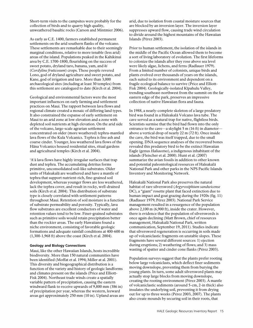
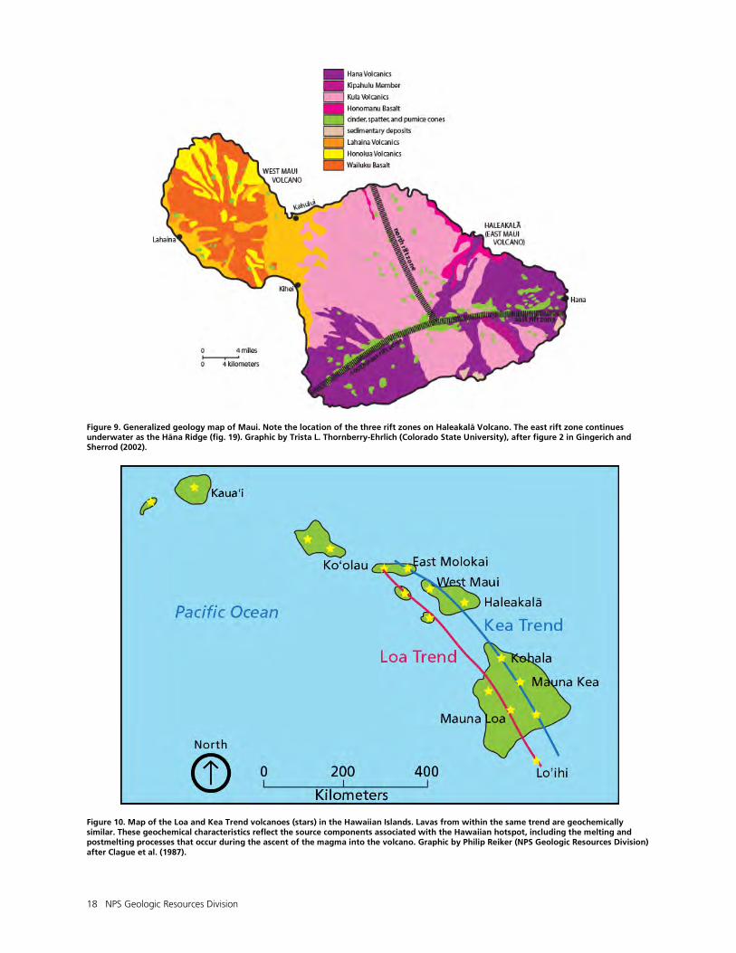
arid, due to isolation from coastal moisture sources that are blocked by an inversion layer. The inversion layer suppresses upward flow, causing trade wind circulation to divide around the highest mountains of the Hawaiian Islands (Pérez 2003). Prior to human settlement, the isolation of the islands in the middle of the Pacific Ocean allowed them to become a sort of living laboratory of evolution. The first lifeforms to colonize the islands after they rose above sea level were likely algae, lichens, and ferns (Radlauer 1979). From a limited number of colonists, unique birds and plants evolved over thousands of years on the islands, each suited to its environment and dependent on a fragile ecological balance to survive (Price and Elliott-Fisk 2004). Geologically-isolated Kīpahulu Valley, trending southeast-northwest from the summit on the far eastern edge of the park, preserves an impressive collection of native Hawaiian flora and fauna. In 1988, a nearly-complete skeleton of a large predatory bird was found in a Haleakalā Volcano lava tube. The cave served as a natural trap for native, flightless birds. Scientists surmise that the bird had flown into the only entrance to the cave—a skylight 5 m (16 ft) in diameter—above a vertical drop of nearly 22 m (72 ft). Once inside the cave, the bird was itself trapped, due to the small opening. DNA sequence analyses of the recovered bones revealed this predatory bird to be the extinct Hawaiian Eagle (genus Haliaeetus), a indigenous inhabitant of the islands (Fleischer et al. 2000). Hunt et al. (2007) summarize the avian fossils in addition to other known and potential paleontological resources of Haleakalā National Park and other parks in the NPS Pacific Islands Inventory and Monitoring Network. Haleakalā National Park also preserves the natural habitat of rare silversword (Argyroxiphium sandwicense DC), a “giant” rosette plant that faced extinction due to human impact and goat grazing during the 1920s (fig. 11) (Radlauer 1979; Pérez 2003). National Park Service management resulted in a resurgence of the population above 2,100 m (6,900 ft), inside the crater. However, there is evidence that the population of silverswords is once again declining (Matt Brown, chief of resources management, Haleakalā National Park, written communication, September 19, 2011). Studies indicate that silversword regeneration is occurring in soils made up of volcaniclastic fragments on unstable slopes. These fragments have several different sources: 1) ejection during eruptions; 2) weathering of flows; and 3) mass wasting of spatter and cinder cone flanks (Pérez 2003). Population surveys suggest that the plants prefer rooting below large volcaniclasts, which deflect finer sediments moving downslope, preventing them from burying the young plants. In turn, some adult silversword plants may actually stop large blocks from moving downslope, creating the rooting environment (Pérez 2003). A mantle of volcaniclastic sediments (around 5-cm, 2-in thick) also insulates the underlying soil, preventing it from drying out for up to three weeks (Pérez 2003, 2007). The plants also create mounds by securing soil in their roots, that
16 NPS Geologic Resources Division
redirect erosive wind flow, and by deflecting raindrops with their leaves (Pérez 2007). Geology, biology, and climate influence soil development on Haleakalā Volcano’s slopes. Iron oxides, abundant in lava-derived soils, act as sorbents for nutrients, pollutants, and natural organic matter. Fluctuating iron oxidation states prevail in different climates as a function of the amount of precipitation (Thompson et al. 2002). Thus, different climatic areas correspond to different biological zones, based on geologically-controlled substrates. Further study might reveal how nutrients such as phosphates, pollutants such as heavy metals, and natural organic matter are distributed with respect to substrate in Haleakalā’s soils. The NPS Soil Resources Inventory developed a soils map and database for the park (National Park Service 2005).
Martian Comparisons
Haleakalā Volcano, like other Hawaiian volcanoes, has served as a proxy for Martian landscapes. Comparisons, such as that of the evolution of drainage valleys dissecting volcanoes, are found on the similarly exposed landscapes of Hawaii. Drainage valleys in volcanic rocks will not develop until a less permeable ash mantle is emplaced, or until weathering reduces the permeability of the volcanic strata. The Kaupō and Ke‘anae Valleys on Haleakalā are remarkably similar to that of Tyrrhena Patera of Mars (Baker 1988). As mentioned in the previous section on glaciation, the origin of two of Haleakalā’s large valleys is somewhat enigmatic. A greater understanding of how these valleys formed will no doubt add to the knowledge of Martian geomorphological processes and to the debate about the presence of fluvial weathering on the Martian surface. Studies of Hawaiian features and processes as proxies for those of Mars also extends to soil development and the creation of microclimates (Bishop et al. 1997; Kadish 2007). The mineralogy of Martian soil, sampled at the Viking and Pathfinder sites, Gusev crater, Meridiani Planum, and measured via imaging spectrometers, suggest substantial mixing taking place following alteration on the Martian surface (Bishop et al. 1997; Bishop et al. 2006). Martian soils are high in Fe3+ and Si, with 1-7% of a highly magnetic material (Bishop et al. 1997). Altered tephra of Haleakalā Volcano contains amorphous silica, jarosite, iron oxide, and phyllosilicates are very similar to those observed for the Martian soil, suggest that their mode of formation may also be similar (Bishop et al. 2003; Bishop et al. 2006). At Haleakalā the altered tephra material is exposed to gradual, low-moisture weathering (as well as weathering associated with water and sulfurous volcanic gases) such as might exist on Mars (Bishop et al. 2006). Like the Hawaiian volcanic masses, the Tharsis rise, containing the mountainous masses of Olympus Mons and the Tharsis Montes, forms huge lateral and vertical topographic structures that have a major influence on regional circulation patterns in the Martian atmosphere. In Hawaii, changes in atmospheric circulation impact the
nature and intensity of eolian, glacial and other water-related geological processes. Substantial changes in elevation, wind direction (trade winds), precipitation, and temperatures create a situation conducive to highly variable microclimates. Studying the microclimates of Maui and how they relate to topography can be extended to Martian landscapes, while exercising much caution given the substantial differences between the atmospheres of Earth and Mars (Kadish 2007).
Geothermal Resource Potential
Haleakalā National Park is one of 16 National Park Service areas requiring an inventory of significant thermal features as part of the Geothermal Steam Act of 1970 (as amended in 1988). As part of the Hawaii Geothermal Resources Assessment Program, initiated in 1978, Haleakalā Volcano was examined for inclusion as a Potential Geothermal Resource Area (PGRA). In 1985, field studies of the three major rift zones (northwest, east, and southwest) on Haleakalā revealed the area of greatest potential was the southwest rift area, also the area of most recent volcanism. However, in a recent update, wells outside the rift zone showed no elevated temperatures or chemical evidence of geothermal heating. Still, in the absence of new geothermal exploration data, the probability estimates remain the same (Thomas 1985; GeothermEx, Inc. 2000). Geophysical soundings indicated that thermal groundwater may be present at less than 3 m (10 ft) depth for some of Maui (Thomas 1985, 1986). The northwest and east rift zones were also surveyed and may have geothermal resource potential (Thomas 1985). Geothermal potential is limited by the local supply of groundwater. Geothermal resource development is prone to several geologic hazards including volcanic eruptions and seismicity. Ground cracks, frequently accompanying both hazards, could severely compromise a geothermal plant, rupturing pipes, creating alternate steam paths, and cracking foundations. Similarly, ground subsidence, caused by volcanic or tectonic unrest, may interrupt the geothermal fluid flow pattern (Kubacki et al. 1984). Any geothermal development plans would need to assess potential risk for ground rupture and subsidence. Mitigation methods include strategic siting, fortified construction designs, evacuation planning, and decentralization of facilities (Kubacki et a. 1984). Even if geothermal energy is developed beyond park boundaries, the effects of geothermal development on the regional environment is something park resource managers should be aware of. Meteorological conditions, especially wind, can affect the distribution of emissions and therefore air quality and noise impacts. Native flora and fauna may be impacted, and the hydrologic cycle altered. Scenic viewsheds may be compromised by geothermal plant development, since it may require constructing high cooling towers, transmission lines, and deforesting large sites (Samuels and Tagomori 1984). Contact the NPS Geologic Resources Division for assistance with geothermal resource issues.
HALE Geologic Resources Inventory Report 17
Figure 8. Photograph of the crater at Haleakalā Volcano. Note the diagonal line of small cinder cones and the young, darker lava flows in left center. The cones and flows are part of the Hāna Volcanics (Qhn units). The crater wall in the background (Hanakauhi) is mapped as lava flows of the older Kula Volcanics (Qkul). See “Geologic Map Data” section for more information. Photograph by Trista L. Thornberry-Ehrlich (Colorado State University).
18 NPS Geologic Resources Division
Figure 9. Generalized geology map of Maui. Note the location of the three rift zones on Haleakalā Volcano. The east rift zone continues underwater as the Hāna Ridge (fig. 19). Graphic by Trista L. Thornberry-Ehrlich (Colorado State University), after figure 2 in Gingerich and Sherrod (2002).
Figure 10. Map of the Loa and Kea Trend volcanoes (stars) in the Hawaiian Islands. Lavas from within the same trend are geochemically similar. These geochemical characteristics reflect the source components associated with the Hawaiian hotspot, including the melting and postmelting processes that occur during the ascent of the magma into the volcano. Graphic by Philip Reiker (NPS Geologic Resources Division) after Clague et al. (1987).
HALE Geologic Resources Inventory Report 19
Figure 11. Silversword. Haleakalā National Park preserves the natural habitat of rare silversword (Argyroxiphium sandwicense DC), a “giant” rosette plant that faced extinction due to human impact and goat grazing during the 1920s. The plant can exceed 2 m (7 ft) in height. National Park Service photograph courtesy Russell Shurtz (Haleakalā National Park).


HALE Geologic Resources Inventory Report 21
Geologic History
This section describes the rocks and unconsolidated deposits that appear on the digital geologic map of Haleakalā National Park, the environment in which those units were deposited, and the timing of geologic events that formed the present landscape. In geologic terms, the rock units of Haleakalā Volcano are very young—dating back about 1.1 million years—in comparison to the more than 4 billion year history of planet Earth (figs. 12 and 13) (Clague and Dalrymple 1987; Rubin 2005). Haleakalā Volcano erupted as recently as about 400 years ago. The geologic evolution of the Pacific basin, including the Hawaiian Islands, is a key event in Earth’s history. Knowledge of how the islands formed contributes to understanding the current landscape and to predicting potential future geologic events.
Pre-Quaternary History of the Pacific Basin
In the late Paleozoic, all continental landmasses joined to form one large supercontinent called “Pangaea.” During this time, mountain ranges such as the Appalachians, formed by continental collision. A huge water body, the Panthallassic Ocean, surrounded Pangaea. The supercontinent Pangaea began to break apart early in the Triassic Period. Pangaea split into a northern continent called Laurasia and a southern continent called Gondwana. Further rifting divided Laurasia into the North American and Eurasian continents, whereas Gondwana eventually separated into the continents of South America, Africa, Australia, and Antarctica (Condie and Sloan 1998). Continental rifting (extension) opened new oceans, such as the Atlantic Basin, between the Americas, and between Europe and Africa. The Indian Ocean Basin formed between Africa, Antarctica, and Australia. Rifting continued throughout the Mesozoic. The oceanic crust of the Panthallassic Ocean Basin was also changing and splitting during this time. Approximately 125 million years ago (early to middle Cretaceous), evidence suggests that a massive increase in volcanic activity in the western Pacific Ocean Basin produced large volcanic plateaus above several large mantle plumes. This activity was concurrent with a rapid increase in sea-floor spreading rates (speed at which oceanic crust on one side of the rift moved with respect to the other side). Rates increased by 50% to 100%, and remained high until the late Cretaceous (Condie and Sloan 1998). This activity correlates with rising sea level, global climate change (warming), and several extinction events in the middle Cretaceous. The present Pacific plate fills most of the North Pacific Ocean Basin, but this situation was not always so. The Pacific plate, on which the Hawaiian-Emperor volcanic chain is located, is relatively young in geologic terms. In the Cretaceous, several plates existed within the basin, likely derived from the partitioning of the Panthalassic Ocean upon the breakup of Pangaea.
The Pacific plate started as a small central plate, surrounded by the Aluk plate to the south, the Farallon plate to the east, and the Kula plate to the north (fig. 14) (Condie and Sloan 1998; University of California Santa Barbara 2006). Separated by mid-ocean ridges, the plates surrounding the Pacific plate began moving away from it. During the middle Tertiary, the surrounding plates had mostly assimilated into the earth’s crust by subduction. Oceanic crust is denser than continental crust; thus, in a collision between the two, the oceanic crust tends to sink (subduct) beneath the continental crust. This subduction generates heat, as the plate sinks into the upper mantle. The oceanic crust melts and rises to the surface, often forming a volcanic arc above the melting plate, in effect recycling the oceanic crust material. The Kula plate plunged into the mantle at the northeast Asian subduction zone, possibly coinciding with the opening of the Sea of Japan. The Farallon plate subducted beneath North and South America resulting in the Sevier-Laramide orogenic event. Remnants of this plate include the Juan de Fuca plate off the coast of Oregon and Washington, the Cocos plate off the coast of Central America, and the Nazca plate subducting beneath South America (Condie and Sloan 1998). During this time, the Pacific plate had been enlarged by seafloor spreading, nearly filling the north Pacific Basin. It now is moving slowly northward and westward—toward the subduction zones bordering the Australian-Indian plate, the Philippine plate, the Eurasian plate and the Aleutian Islands of the North American plate (figs. 4 and 15) (University of California Santa Barbara 2006).
Evolution of the Hawaiian-Emperor Seamount Chain
The Pacific plate now covers about 20% of the Earth’s crust, and is the largest tectonic plate on the planet (fig. 15). There are linear chains of volcanic islands and seamounts (submerged volcanoes) throughout the Pacific basin. The linear trend of the Hawaiian-Emperor islands and seamounts records the movement of the Pacific plate over a stationary hotspot in the upper mantle (fig. 4). Other such spots across the basin are the Caroline, Marquesas, Society, Pitcairn, Austral, and Easter hotspots (fig.16) (Condie and Sloan 1998). Hotspots form as a result of rising plumes of very high temperature material from the lower mantle, just above the core-mantle interface. These plumes are thought to form as a result of localized thermal disturbances in the molten core of the earth. A portion of the core cools, causing the overlying mantle to heat up and rise because of to its decreased density. Once the plumes reach the
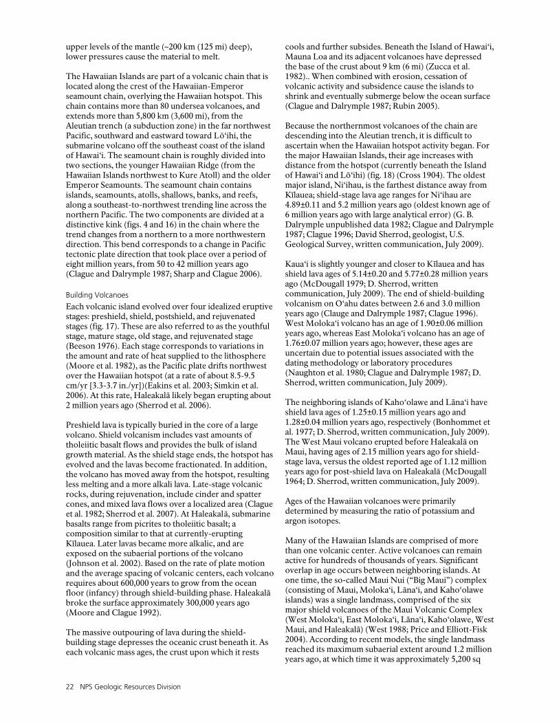
22 NPS Geologic Resources Division
upper levels of the mantle (~200 km (125 mi) deep), lower pressures cause the material to melt. The Hawaiian Islands are part of a volcanic chain that is located along the crest of the Hawaiian-Emperor seamount chain, overlying the Hawaiian hotspot. This chain contains more than 80 undersea volcanoes, and extends more than 5,800 km (3,600 mi), from the Aleutian trench (a subduction zone) in the far northwest Pacific, southward and eastward toward Lō‘ihi, the submarine volcano off the southeast coast of the island of Hawai‘i. The seamount chain is roughly divided into two sections, the younger Hawaiian Ridge (from the Hawaiian Islands northwest to Kure Atoll) and the older Emperor Seamounts. The seamount chain contains islands, seamounts, atolls, shallows, banks, and reefs, along a southeast-to-northwest trending line across the northern Pacific. The two components are divided at a distinctive kink (figs. 4 and 16) in the chain where the trend changes from a northern to a more northwestern direction. This bend corresponds to a change in Pacific tectonic plate direction that took place over a period of eight million years, from 50 to 42 million years ago (Clague and Dalrymple 1987; Sharp and Clague 2006).
Building Volcanoes
Each volcanic island evolved over four idealized eruptive stages: preshield, shield, postshield, and rejuvenated stages (fig. 17). These are also referred to as the youthful stage, mature stage, old stage, and rejuvenated stage (Beeson 1976). Each stage corresponds to variations in the amount and rate of heat supplied to the lithosphere (Moore et al. 1982), as the Pacific plate drifts northwest over the Hawaiian hotspot (at a rate of about 8.5-9.5 cm/yr [3.3-3.7 in./yr])(Eakins et al. 2003; Simkin et al. 2006). At this rate, Haleakalā likely began erupting about 2 million years ago (Sherrod et al. 2006). Preshield lava is typically buried in the core of a large volcano. Shield volcanism includes vast amounts of tholeiitic basalt flows and provides the bulk of island growth material. As the shield stage ends, the hotspot has evolved and the lavas become fractionated. In addition, the volcano has moved away from the hotspot, resulting less melting and a more alkali lava. Late-stage volcanic rocks, during rejuvenation, include cinder and spatter cones, and mixed lava flows over a localized area (Clague et al. 1982; Sherrod et al. 2007). At Haleakalā, submarine basalts range from picrites to tholeiitic basalt; a composition similar to that at currently-erupting Kīlauea. Later lavas became more alkalic, and are exposed on the subaerial portions of the volcano (Johnson et al. 2002). Based on the rate of plate motion and the average spacing of volcanic centers, each volcano requires about 600,000 years to grow from the ocean floor (infancy) through shield-building phase. Haleakalā broke the surface approximately 300,000 years ago (Moore and Clague 1992). The massive outpouring of lava during the shield-building stage depresses the oceanic crust beneath it. As each volcanic mass ages, the crust upon which it rests
cools and further subsides. Beneath the Island of Hawai‘i, Mauna Loa and its adjacent volcanoes have depressed the base of the crust about 9 km (6 mi) (Zucca et al. 1982).. When combined with erosion, cessation of volcanic activity and subsidence cause the islands to shrink and eventually submerge below the ocean surface (Clague and Dalrymple 1987; Rubin 2005). Because the northernmost volcanoes of the chain are descending into the Aleutian trench, it is difficult to ascertain when the Hawaiian hotspot activity began. For the major Hawaiian Islands, their age increases with distance from the hotspot (currently beneath the Island of Hawai‘i and Lō‘ihi) (fig. 18) (Cross 1904). The oldest major island, Ni‘ihau, is the farthest distance away from Kīlauea; shield-stage lava age ranges for Ni‘ihau are 4.89±0.11 and 5.2 million years ago (oldest known age of 6 million years ago with large analytical error) (G. B. Dalrymple unpublished data 1982; Clague and Dalrymple 1987; Clague 1996; David Sherrod, geologist, U.S. Geological Survey, written communication, July 2009). Kaua‘i is slightly younger and closer to Kīlauea and has shield lava ages of 5.14±0.20 and 5.77±0.28 million years ago (McDougall 1979; D. Sherrod, written communication, July 2009). The end of shield-building volcanism on O‘ahu dates between 2.6 and 3.0 million years ago (Clauge and Dalrymple 1987; Clague 1996). West Moloka‘i volcano has an age of 1.90±0.06 million years ago, whereas East Moloka‘i volcano has an age of 1.76±0.07 million years ago; however, these ages are uncertain due to potential issues associated with the dating methodology or laboratory procedures (Naughton et al. 1980; Clague and Dalrymple 1987; D. Sherrod, written communication, July 2009). The neighboring islands of Kaho‘olawe and Lāna‘i have shield lava ages of 1.25±0.15 million years ago and 1.28±0.04 million years ago, respectively (Bonhommet et al. 1977; D. Sherrod, written communication, July 2009). The West Maui volcano erupted before Haleakalā on Maui, having ages of 2.15 million years ago for shield-stage lava, versus the oldest reported age of 1.12 million years ago for post-shield lava on Haleakalā (McDougall 1964; D. Sherrod, written communication, July 2009). Ages of the Hawaiian volcanoes were primarily determined by measuring the ratio of potassium and argon isotopes. Many of the Hawaiian Islands are comprised of more than one volcanic center. Active volcanoes can remain active for hundreds of thousands of years. Significant overlap in age occurs between neighboring islands. At one time, the so-called Maui Nui (“Big Maui”) complex (consisting of Maui, Moloka‘i, Lāna‘i, and Kaho‘olawe islands) was a single landmass, comprised of the six major shield volcanoes of the Maui Volcanic Complex (West Moloka‘i, East Moloka‘i, Lāna‘i, Kaho‘olawe, West Maui, and Haleakalā) (West 1988; Price and Elliott-Fisk 2004). According to recent models, the single landmass reached its maximum subaerial extent around 1.2 million years ago, at which time it was approximately 5,200 sq

HALE Geologic Resources Inventory Report 23
km (2,000 sq mi). It was a single landmass for more than 75% of its history (Sinton 1987; Price and Elliott-Fisk 2004). Subsidence, erosion, and relative sea level rise drowned the bridges between the present islands by 100-200 thousand years ago (see bathymetric map, fig. 19) (Price and Elliott-Fisk 2004).
Volcanoes of Maui
The island of Maui consists of two volcanoes, West Maui and Haleakalā (East Maui). Ranging in age from about 2 to 1.3 million years old, the Waikulu basalt represents the oldest rocks associated with West Maui Volcano, and the oldest exposed on the island. The youngest volcanic rocks from West Maui are about 300,000 to 400,000 years old (Sherrod et al. 2007). The oldest rocks of Haleakalā Volcano—the Honomanū Basalt—are approximately 1.1 million years old (Sherrod et al. 2007). The volcano most recently erupted about 400 years ago (around C.E. 1600, its frequently cited age of C.E. 1790 is too young), even though it is 200 km (125 mi) from Kīlauea volcano on Hawai‘i (Rubin 2005; Sherrod 2002). Haleakalā intermittently erupts every 200-500 years (Sherrod et al. 2006). Haleakalā is considered potentially active, the only such volcano not on the Island of Hawaii (Porter et al. 1977; Rubin 2005; Sherrod 2002; Sherrod et al. 2007). The most recent eruptive period emplaced the Hāna Volcanics group (geologic map units beginning with Qhn) (fig. 20). The Hāna Volcanics followed the eruption of the Kula Volcanics (units beginning with Qkul), ending at approximately 150,000 years ago. These deposits followed the eruption of the Honomanū Basalt (unit Qmnl). The most recent Hāna volcanic activity concentrated along the southwest rift zone of Haleakalā Volcano, from two vents at altitudes of 472 m (1,549 ft) and 155 m (509 ft) above sea level. This activity produced approximately 27 million cubic meters of lava (Thomas 1985; Sherrod et al. 2006). The volumetric extrusion rate (amount of lava erupted for a unit of time) for Haleakalā has remained more or less constant at 0.05-0.15 km3/thousand years (0.01-0.04 mi3/thousand years), for the past 13,000 years (Sherrod et al. 2006). The younger Hāna Volcanic group includes lava flows, vent deposits, tephra deposits, some intrusive rocks, and explosion crater deposits. The lava flows contain both ‘a‘ā and pāhoehoe types. Unconsolidated deposits include lapilli, ash, and crystals which are locally reworked by eolian processes. Rocks found within the Kula Volcanics are from the alkali-olivine basalt suite of lavas. This suite includes lavas classified as hawaiite, mugearite, trachyte, and basanite in flows, vent deposits of spatter and cinders, and some intrusive dikes and plugs. Textures in these rocks range from aphyric (no visible large crystals) to porphyritic (crystals in a fine-grained to glassy matrix) (Hackett 1987; Sherrod et al. 2007). Hawaiite lavas contain more gas than basalts and cause more explosive eruptions (Macdonald 1978).
Locally, a thin layer of red ashy soil separates the Kula volcanics from the underlying Honomanū Basalt (Sinton 1987). The Honomanū Basalt consists of both ‘a‘ā and pāhoehoe lava flows in the northern coastal areas. This unit is a useful marker, since its magnetization is reversed-polarity, in contrast with younger flows from Haleakalā (Sherrod et al. 2007). The Honomanū Basalt outcrops along the northern sea wall and incised valleys (Sinton 1987).
Modification of the Volcanic Landscape
Submarine mass wasting, landslides, and debris flows carry material from the shoreline down the slopes of the islands onto the deep sea floor. This process often leaves steep lava benches, precipitous slopes, and cliffs on island shorelines. These mass movements have been an important and ongoing influence on the development of the island volcanic complex of all the Hawaiian Islands (Moore et al. 1989; Keating et al. 2000). Submarine mapping reveals that the Hāna Ridge (also called the Haleakalā Ridge), the submarine extension of the east rift zone of Haleakalā, is capped by coral-reef terraces (fig. 19). These delineate former shorelines that have been tilted (analogous to tilting along a hinge) towards the axis of the Hawaiian Ridge to the south (Eakins and Robinson 2002; Moore et al. 1988, Moore et al. 1990). The reefs were tilted after growth, and further submerged by a sea level rise less than 750,000 ± 13,000 years ago (Moore et al. 1988; Moore et al. 1990). The reefs have subsided as much as 2,200 m (7,200 ft) (Moore et al. 1990). The 135-km-long (84-mi-long) Hāna Ridge (longest in Hawaii) has a complex lobate morphology typical of the sections of Hawaiian rift zones that erupt underwater (Eakins and Robinson 2002; Eakins and Robinson 2006). The ridge also contains arcuate (crescent-shaped) landslide scars. One of these, the Hāna slump, is a series of filled basins and tilted ridges that extends down several kilometers to the Hawaiian moat, a slump landform caused by crustal loading of the volcanic masses (Eakins and Robinson 2002). The area of the slump covers 3,000 km2 (1,200 mi2). The slump likely developed over time, driven by magmatic inflation along the rift zone and subsequent gravitational collapse (Eakins and Robinson 2006). Haleakalā Volcano was also shaped by glaciers during the Pleistocene ice ages. First appearing about 800,000 years ago, ice caps on the summit advanced and retreated over about 400,000 years until island subsidence, erosion, and diminishing eruptive activity lowered the summit below the snow line (Porter 2005). As on other volcanic islands throughout the Pacific Ocean basin, the landscape of Maui experiences intense weathering and erosion in the tropical Hawaiian climate. Resultant landforms may include steep-sided stream valleys, dissected volcanic plateaus, alternating valley and ridge topography, small-scale gullies, isolated plateau remnants, talus slope deposits, levee deposits, sea cliffs and benches (Ollier 1988). On Haleakalā, two valleys coalesced, forming the “crater” between 150,000 and
24 NPS Geologic Resources Division
120,000 years ago. As the Kaupō Valley encroached headward, its upper montane slope collapsed, forming a massive debris deposit—the Kaupō Mud Flow (units Qkamd and Qkamc) (Sherrod 2002). Large clasts and fragments, embedded in a poorly-sorted, fine-grained matrix, characterize these rock units. The conglomerate member contains some rounded, stratified clasts (Sherrod et al. 2007). Eroded volcanics and coralline sediments (in lowest elevation areas) mostly compose the predominantly unconsolidated sedimentary units in the Haleakalā National Park area. They are testament to the ongoing processes of weathering, erosion, and eustatic processes. These units include older terrace deposits of alluvium and younger alluvium lining waterways and filling valley bottoms. At the bases of most steep slopes are deposits of colluvium, landslides, and talus. Younger beach and dune deposits of mixed sands and shell fragments parallel coastlines and fill sheltered embayments around
the island (Sherrod et al. 2007). On the east coast of Maui, the Hōkū‘ula Beach contains sand formed from cinders eroded from the flanks of a nearby cinder cone. These sands are bright and brick-red colored, with vesicles visible to the naked eye in the polished clasts (Elliot and Wendt 1985). Ocean waves continuously modify the shorelines, carrying away sands and gravels eroded by the islands’ rivers. Coral reefs fringe certain areas of the islands, and contribute carbonate sediments to the island’s beaches and younger dune deposits (units Qbd and Qdy) (Sherrod et al. 2007). Humans contribute to the modification of the landscape. Artificial fill (unit Qf) and other coastal engineering structures can interrupt natural sediment transport to and from the shores of Maui. Roads and trails cross diverse ecosystems throughout Haleakalā National Park.
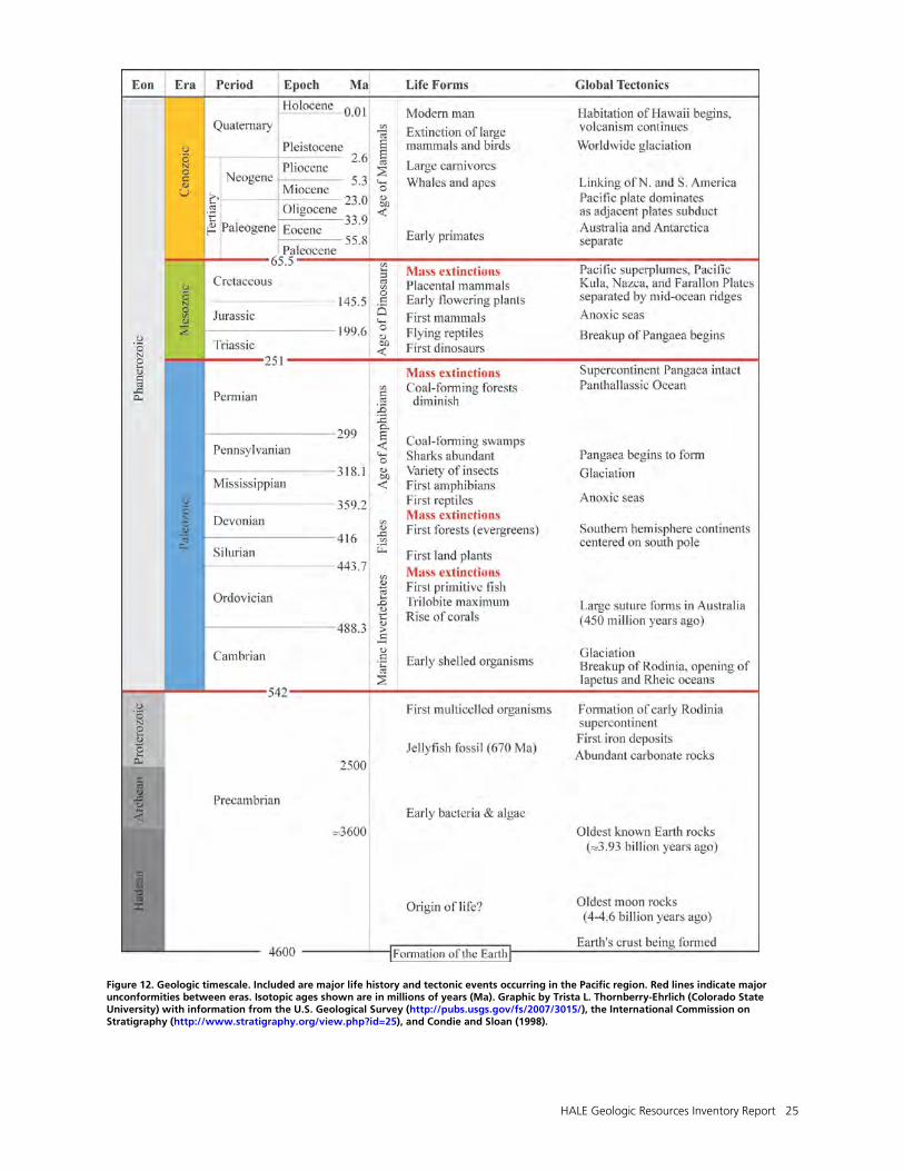
HALE Geologic Resources Inventory Report 25
Figure 12. Geologic timescale. Included are major life history and tectonic events occurring in the Pacific region. Red lines indicate major unconformities between eras. Isotopic ages shown are in millions of years (Ma). Graphic by Trista L. Thornberry-Ehrlich (Colorado State University) with information from the U.S. Geological Survey (http://pubs.usgs.gov/fs/2007/3015/), the International Commission on Stratigraphy (http://www.stratigraphy.org/view.php?id=25), and Condie and Sloan (1998).
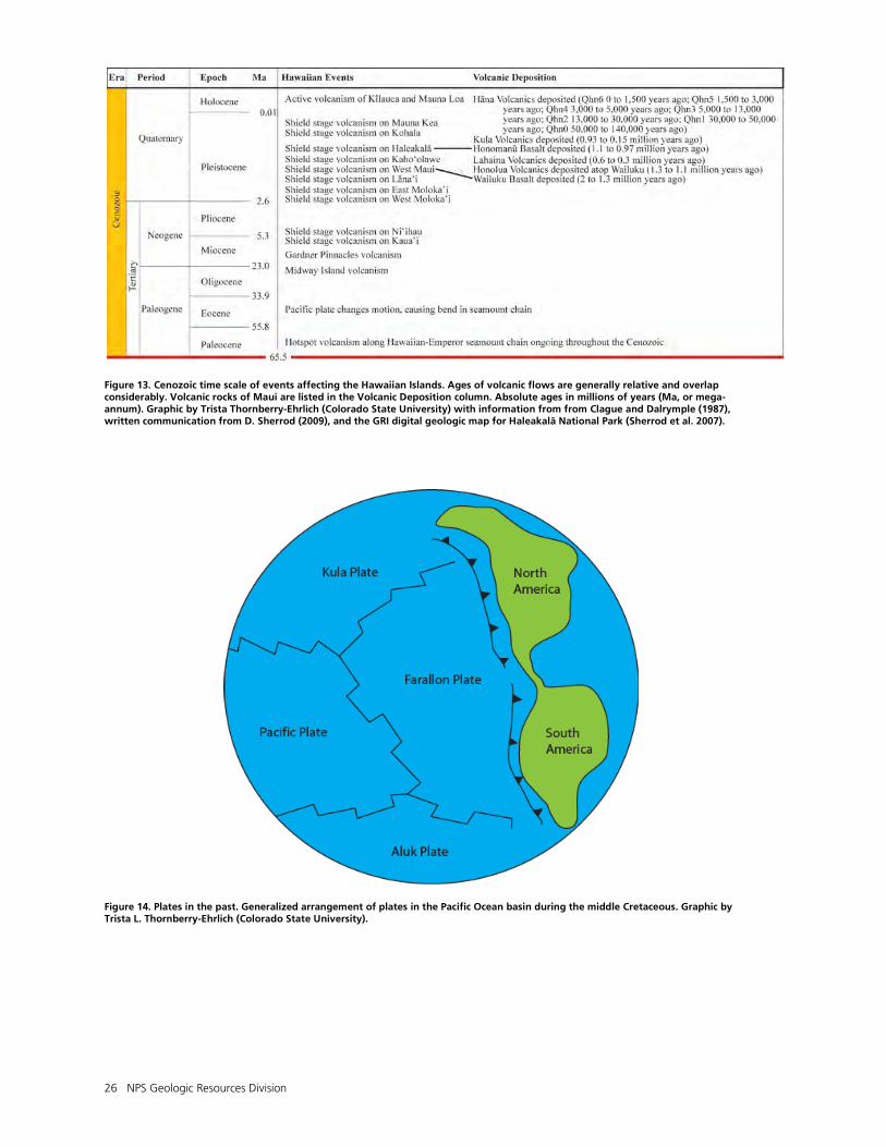
26 NPS Geologic Resources Division
Figure 13. Cenozoic time scale of events affecting the Hawaiian Islands. Ages of volcanic flows are generally relative and overlap considerably. Volcanic rocks of Maui are listed in the Volcanic Deposition column. Absolute ages in millions of years (Ma, or mega-annum). Graphic by Trista Thornberry-Ehrlich (Colorado State University) with information from from Clague and Dalrymple (1987), written communication from D. Sherrod (2009), and the GRI digital geologic map for Haleakalā National Park (Sherrod et al. 2007).
Figure 14. Plates in the past. Generalized arrangement of plates in the Pacific Ocean basin during the middle Cretaceous. Graphic by Trista L. Thornberry-Ehrlich (Colorado State University).

HALE Geologic Resources Inventory Report 27
Figure 15. Map of the current tectonic plates. The Hawaiian Islands are circled. Divergent boundaries are where plates are pulling apart. Plates come together at convergent boundaries and slide past one another at transform boundaries. Graphic courtesy Robert J. Lillie (Oregon State University), modified from Lillie (2005).
Figure 16. Tectonic setting of the Pacific Plate. This figure illustrates many of the features described in the Geologic History section. Note the extent of the Emperor Seamounts and Hawaiian Islands. Currently the Pacific Plate is moving to the northwest at about 95 mm (3.7 in.) per year. The “kink” between the Emperor Seamounts and Hawaiian Islands chain shows how the direction of motion changed while the Hawaiian hotspot remained stationary (see figs. 4 and 18). Selected hotspots across the Pacific Ocean are indicated by red triangles. Boundaries between plates are color coded. Divergent boundaries (red) are where plates are pulling apart. Plates come together at convergent boundaries (green; green triangles indicate overriding plate at subduction zone), and slide past one another at transform boundaries (yellow). Compiled by Jason Kenworthy (NPS Geologic Resources Division from ESRI Arc Image Service Imagery Prime World 2D, with information from figure 2 in Clouard and Bonneville (2001).

28 NPS Geologic Resources Division
Figure 17. Simplified stages of Hawaiian hotspot island volcanism. After volcanism ceases, erosion and subsidence slowly lower the island into the sea. Graphic by Trista L. Thornberry-Ehrlich (Colorado State University) after Stearns (1946) and figure 29 in Keating (1992).
Figure 18. Ages of shield-stage volcanism. Over time, the Pacific Plate moved over a stationary hotspot, forming shield volcanoes. As volcanoes move away from the hotspot, they ultimately become inactive. Inactive volcanic islands subside and erode, eventually dropping below sea level. Ages are in millions of years. The specific type of age, error, and source are detailed in the text. Graphic by Trista L. Thornberry-Ehrlich (Colorado State University), after http://geology.uprm.edu/Morelock/1_image/seamt.jpg. Accessed 16 November 2010.
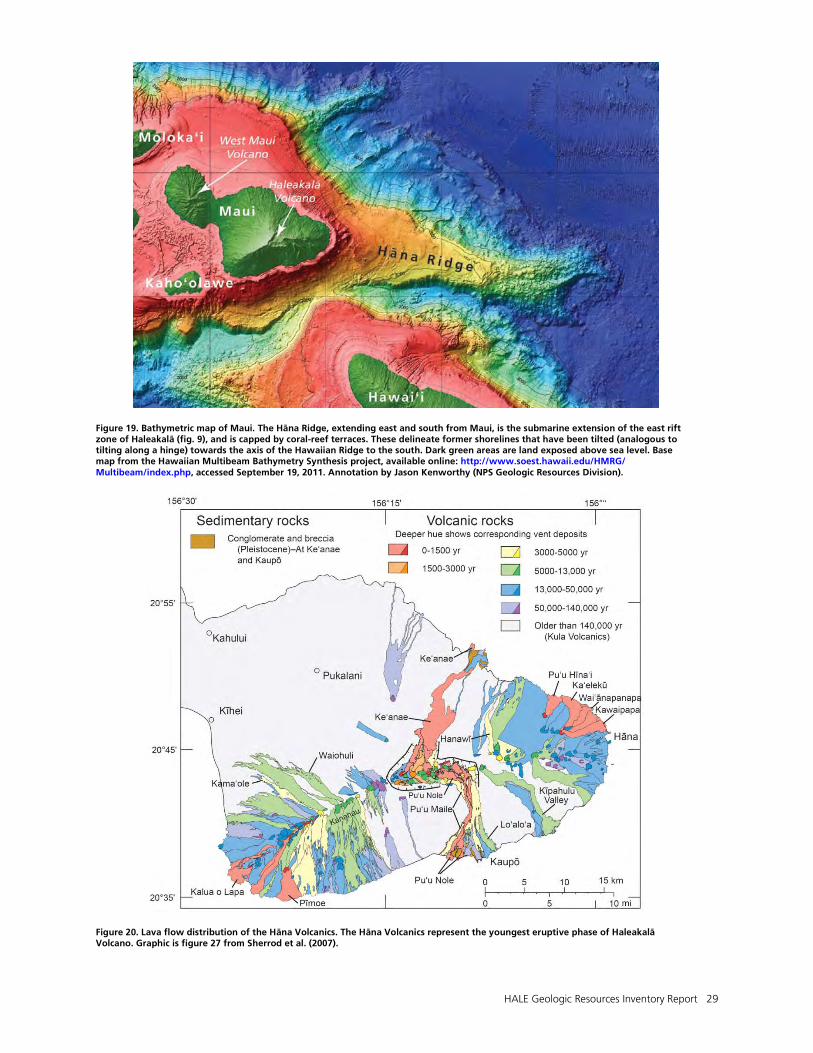
HALE Geologic Resources Inventory Report 29
Figure 19. Bathymetric map of Maui. The Hāna Ridge, extending east and south from Maui, is the submarine extension of the east rift zone of Haleakalā (fig. 9), and is capped by coral-reef terraces. These delineate former shorelines that have been tilted (analogous to tilting along a hinge) towards the axis of the Hawaiian Ridge to the south. Dark green areas are land exposed above sea level. Base map from the Hawaiian Multibeam Bathymetry Synthesis project, available online: http://www.soest.hawaii.edu/HMRG/ Multibeam/index.php, accessed September 19, 2011. Annotation by Jason Kenworthy (NPS Geologic Resources Division).
Figure 20. Lava flow distribution of the Hāna Volcanics. The Hāna Volcanics represent the youngest eruptive phase of Haleakalā Volcano. Graphic is figure 27 from Sherrod et al. (2007).

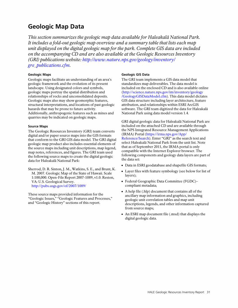
HALE Geologic Resources Inventory Report 31
Geologic Map Data
This section summarizes the geologic map data available for Haleakalā National Park. It includes a fold-out geologic map overview and a summary table that lists each map unit displayed on the digital geologic map for the park. Complete GIS data are included on the accompanying CD and are also available at the Geologic Resources Inventory (GRI) publications website: http://www.nature.nps.gov/geology/inventory/ gre_publications.cfm. Geologic Maps
Geologic maps facilitate an understanding of an area’s geologic framework and the evolution of its present landscape. Using designated colors and symbols, geologic maps portray the spatial distribution and relationships of rocks and unconsolidated deposits. Geologic maps also may show geomorphic features, structural interpretations, and locations of past geologic hazards that may be prone to future activity. Additionally, anthropogenic features such as mines and quarries may be indicated on geologic maps.
Source Maps
The Geologic Resources Inventory (GRI) team converts digital and/or paper source maps into the GIS formats that conform to the GRI GIS data model. The GRI digital geologic map product also includes essential elements of the source maps including unit descriptions, map legend, map notes, references, and figures. The GRI team used the following source maps to create the digital geologic data for Haleakalā National Park: Sherrod, D. R. Sinton, J. M., Watkins, S. E., and Brunt, K.
M. 2007. Geologic Map of the State of Hawaii. Scale 1:100,000. Open-File Report 2007-1089, v1.0. Reston, VA: U.S. Geological Survey. http://pubs.usgs.gov/of/2007/1089/
These source maps provided information for the “Geologic Issues,” “Geologic Features and Processes,” and “Geologic History” sections of this report.
Geologic GIS Data
The GRI team implements a GIS data model that standardizes map deliverables. The data model is included on the enclosed CD and is also available online (http://science.nature.nps.gov/im/inventory/geology /GeologyGISDataModel.cfm). This data model dictates GIS data structure including layer architecture, feature attribution, and relationships within ESRI ArcGIS software. The GRI team digitized the data for Haleakalā National Park using data model version 1.4. GRI digital geologic data for Haleakalā National Park are included on the attached CD and are available through the NPS Integrated Resource Management Applications (IRMA) Portal (https://irma.nps.gov/App/ Reference/Search). Enter “GRI” as the search text and select Haleakalā National Park from the unit list. Note that as of September 2011, the IRMA portal is only compatible with the Internet Explorer browser. The following components and geology data layers are part of the data set:
• Data in ESRI geodatabase and shapefile GIS formats;
• Layer files with feature symbology (see below for list of layers);
• Federal Geographic Data Committee (FGDC)–compliant metadata;
• A help file (.hlp) document that contains all of the ancillary map information and graphics, including geologic unit correlation tables and map unit descriptions, legends, and other information captured from source maps;
• An ESRI map document file (.mxd) that displays the digital geologic data.
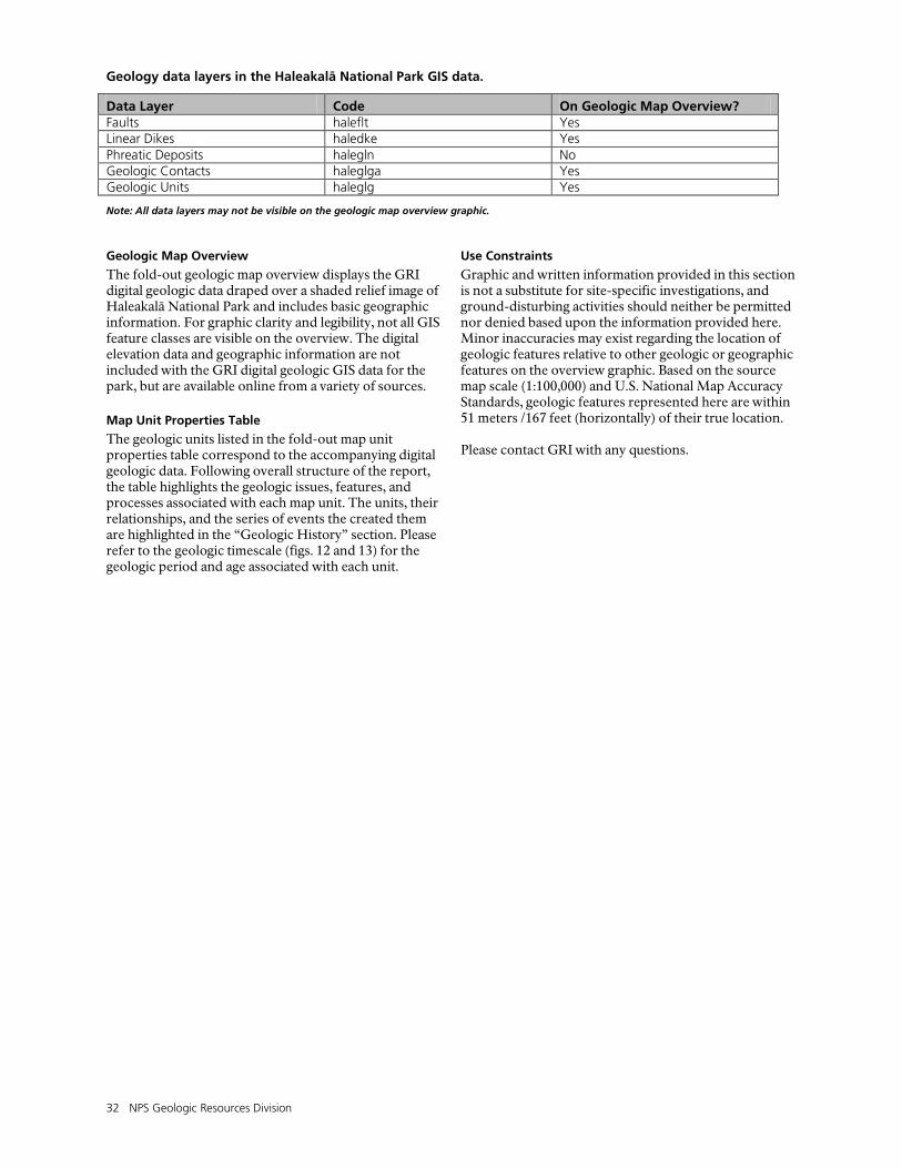
32 NPS Geologic Resources Division
Geology data layers in the Haleakalā National Park GIS data.
Data Layer Code On Geologic Map Overview? Faults haleflt Yes Linear Dikes haledke Yes Phreatic Deposits halegln No Geologic Contacts haleglga Yes Geologic Units haleglg Yes
Note: All data layers may not be visible on the geologic map overview graphic. Geologic Map Overview
The fold-out geologic map overview displays the GRI digital geologic data draped over a shaded relief image of Haleakalā National Park and includes basic geographic information. For graphic clarity and legibility, not all GIS feature classes are visible on the overview. The digital elevation data and geographic information are not included with the GRI digital geologic GIS data for the park, but are available online from a variety of sources.
Map Unit Properties Table
The geologic units listed in the fold-out map unit properties table correspond to the accompanying digital geologic data. Following overall structure of the report, the table highlights the geologic issues, features, and processes associated with each map unit. The units, their relationships, and the series of events the created them are highlighted in the “Geologic History” section. Please refer to the geologic timescale (figs. 12 and 13) for the geologic period and age associated with each unit.
Use Constraints
Graphic and written information provided in this section is not a substitute for site-specific investigations, and ground-disturbing activities should neither be permitted nor denied based upon the information provided here. Minor inaccuracies may exist regarding the location of geologic features relative to other geologic or geographic features on the overview graphic. Based on the source map scale (1:100,000) and U.S. National Map Accuracy Standards, geologic features represented here are within 51 meters /167 feet (horizontally) of their true location. Please contact GRI with any questions.
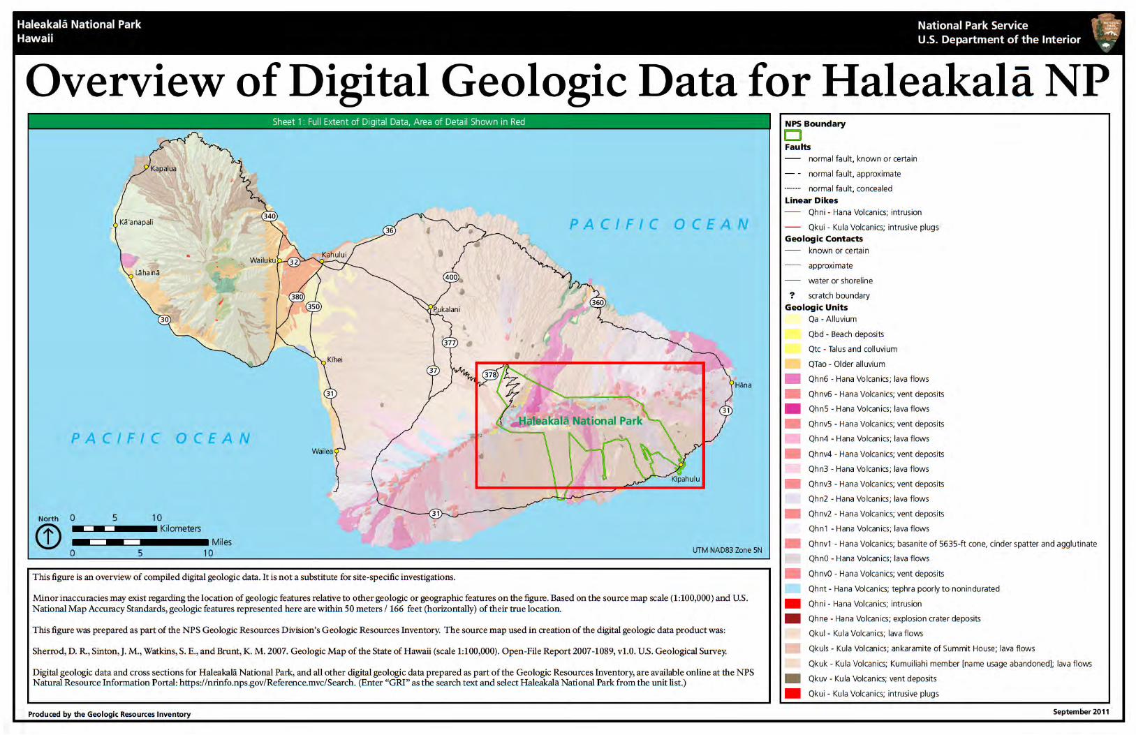

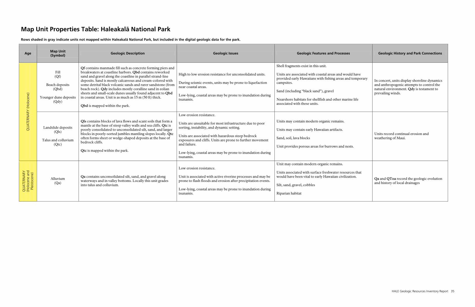
HALE Geologic Resources Inventory Report 35
Map Unit Properties Table: Haleakalā National Park
Rows shaded in gray indicate units not mapped within Haleakalā National Park, but included in the digital geologic data for the park.
Age Map Unit (Symbol)
Geologic Description Geologic Issues Geologic Features and Processes Geologic History and Park Connections
QU
ATE
RNA
RY (H
oloc
ene)
Fill (Qf)
Beach deposits
(Qbd)
Younger dune deposits (Qdy)
Qf contains manmade fill such as concrete forming piers and breakwaters at coastline harbors. Qbd contains reworked sand and gravel along the coastline in parallel strand-line deposits. Sand is mostly calcareous and cream-colored with some detrital black volcanic sands and rarer sandstone (from beach rock). Qdy includes mostly coralline sand in eolian sheets and small-scale dunes usually found adjacent to Qbd in coastal areas. Unit is as much as 15 m (50 ft) thick. Qbd is mapped within the park.
High to low erosion resistance for unconsolidated units. During seismic events, units may be prone to liquefaction near coastal areas. Low-lying, coastal areas may be prone to inundation during tsunamis.
Shell fragments exist in this unit. Units are associated with coastal areas and would have provided early Hawaiians with fishing areas and temporary campsites. Sand (including “black sand”), gravel Nearshore habitats for shellfish and other marine life associated with these units.
In concert, units display shoreline dynamics and anthropogenic attempts to control the natural environment. Qdy is testament to prevailing winds.
Landslide deposits (Qls)
Talus and colluvium
(Qtc)
Qls contains blocks of lava flows and scant soils that form a mantle at the base of steep valley walls and sea cliffs. Qtc is poorly consolidated to unconsolidated silt, sand, and larger blocks in poorly-sorted jumbles mantling slopes locally. Qtc often forms sheet or wedge-shaped deposits at the base of bedrock cliffs. Qtc is mapped within the park.
Low erosion resistance. Units are unsuitable for most infrastructure due to poor sorting, instability, and dynamic setting. Units are associated with hazardous steep bedrock exposures and cliffs. Units are prone to further movement and failure. Low-lying, coastal areas may be prone to inundation during tsunamis.
Units may contain modern organic remains. Units may contain early Hawaiian artifacts. Sand, soil, lava blocks Unit provides porous areas for burrows and nests.
Units record continual erosion and weathering of Maui.
QU
ATE
RNA
RY
(Hol
ocen
e an
d Pl
eist
ocen
e)
Alluvium (Qa)
Qa contains unconsolidated silt, sand, and gravel along waterways and in valley bottoms. Locally this unit grades into talus and colluvium.
Low erosion resistance. Unit is associated with active riverine processes and may be prone to flash floods and erosion after precipitation events. Low-lying, coastal areas may be prone to inundation during tsunamis.
Unit may contain modern organic remains. Units associated with surface freshwater resources that would have been vital to early Hawaiian civilization. Silt, sand, gravel, cobbles Riparian habitat
Qa and QToa record the geologic evolution and history of local drainages
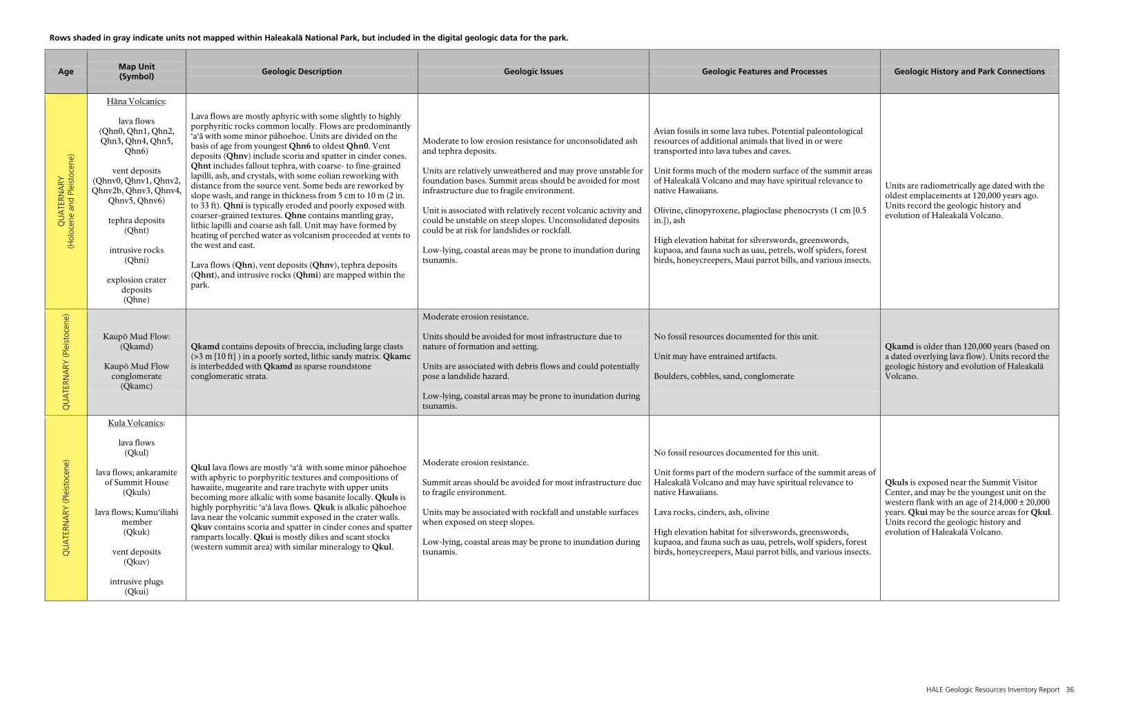
Rows shaded in gray indicate units not mapped within Haleakalā National Park, but included in the digital geologic data for the park.
HALE Geologic Resources Inventory Report 36
Age Map Unit (Symbol)
Geologic Description Geologic Issues Geologic Features and Processes Geologic History and Park Connections Q
UA
TERN
ARY
(H
oloc
ene
and
Plei
stoc
ene)
Hāna Volcanics
:
lava flows (Qhn0, Qhn1, Qhn2, Qhn3, Qhn4, Qhn5,
Qhn6)
vent deposits (Qhnv0, Qhnv1, Qhnv2, Qhnv2b, Qhnv3, Qhnv4,
Qhnv5, Qhnv6)
tephra deposits (Qhnt)
intrusive rocks
(Qhni)
explosion crater deposits (Qhne)
Lava flows are mostly aphyric with some slightly to highly porphyritic rocks common locally. Flows are predominantly ‘a‘ā with some minor pāhoehoe. Units are divided on the basis of age from youngest Qhn6 to oldest Qhn0. Vent deposits (Qhnv) include scoria and spatter in cinder cones. Qhnt includes fallout tephra, with coarse- to fine-grained lapilli, ash, and crystals, with some eolian reworking with distance from the source vent. Some beds are reworked by slope wash, and range in thickness from 5 cm to 10 m (2 in. to 33 ft). Qhni is typically eroded and poorly exposed with coarser-grained textures. Qhne contains mantling gray, lithic lapilli and coarse ash fall. Unit may have formed by heating of perched water as volcanism proceeded at vents to the west and east. Lava flows (Qhn), vent deposits (Qhnv), tephra deposits (Qhnt), and intrusive rocks (Qhmi) are mapped within the park.
Moderate to low erosion resistance for unconsolidated ash and tephra deposits. Units are relatively unweathered and may prove unstable for foundation bases. Summit areas should be avoided for most infrastructure due to fragile environment. Unit is associated with relatively recent volcanic activity and could be unstable on steep slopes. Unconsolidated deposits could be at risk for landslides or rockfall. Low-lying, coastal areas may be prone to inundation during tsunamis.
Avian fossils in some lava tubes. Potential paleontological resources of additional animals that lived in or were transported into lava tubes and caves. Unit forms much of the modern surface of the summit areas of Haleakalā Volcano and may have spiritual relevance to native Hawaiians. Olivine, clinopyroxene, plagioclase phenocrysts (1 cm [0.5 in.]), ash High elevation habitat for silverswords, greenswords, kupaoa, and fauna such as uau, petrels, wolf spiders, forest birds, honeycreepers, Maui parrot bills, and various insects.
Units are radiometrically age dated with the oldest emplacements at 120,000 years ago. Units record the geologic history and evolution of Haleakalā Volcano.
QU
ATE
RNA
RY (P
leis
toce
ne)
Kaupō Mud Flow: (Qkamd)
Kaupō Mud Flow
conglomerate (Qkamc)
Qkamd contains deposits of breccia, including large clasts (>3 m [10 ft] ) in a poorly sorted, lithic sandy matrix. Qkamc is interbedded with Qkamd as sparse roundstone conglomeratic strata.
Moderate erosion resistance. Units should be avoided for most infrastructure due to nature of formation and setting. Units are associated with debris flows and could potentially pose a landslide hazard. Low-lying, coastal areas may be prone to inundation during tsunamis.
No fossil resources documented for this unit. Unit may have entrained artifacts. Boulders, cobbles, sand, conglomerate
Qkamd is older than 120,000 years (based on a dated overlying lava flow). Units record the geologic history and evolution of Haleakalā Volcano.
QU
ATE
RNA
RY (P
leis
toce
ne)
Kula Volcanics
:
lava flows (Qkul)
lava flows; ankaramite
of Summit House (Qkuls)
lava flows; Kumu‘iliahi
member (Qkuk)
vent deposits
(Qkuv)
intrusive plugs (Qkui)
Qkul lava flows are mostly ‘a‘ā with some minor pāhoehoe with aphyric to porphyritic textures and compositions of hawaiite, mugearite and rare trachyte with upper units becoming more alkalic with some basanite locally. Qkuls is highly porphyritic ‘a‘ā lava flows. Qkuk is alkalic pāhoehoe lava near the volcanic summit exposed in the crater walls. Qkuv contains scoria and spatter in cinder cones and spatter ramparts locally. Qkui is mostly dikes and scant stocks (western summit area) with similar mineralogy to Qkul.
Moderate erosion resistance. Summit areas should be avoided for most infrastructure due to fragile environment. Units may be associated with rockfall and unstable surfaces when exposed on steep slopes. Low-lying, coastal areas may be prone to inundation during tsunamis.
No fossil resources documented for this unit. Unit forms part of the modern surface of the summit areas of Haleakalā Volcano and may have spiritual relevance to native Hawaiians. Lava rocks, cinders, ash, olivine High elevation habitat for silverswords, greenswords, kupaoa, and fauna such as uau, petrels, wolf spiders, forest birds, honeycreepers, Maui parrot bills, and various insects.
Qkuls is exposed near the Summit Visitor Center, and may be the youngest unit on the western flank with an age of 214,000 ± 20,000 years. Qkui may be the source areas for Qkul. Units record the geologic history and evolution of Haleakalā Volcano.

Rows shaded in gray indicate units not mapped within Haleakalā National Park, but included in the digital geologic data for the park.
HALE Geologic Resources Inventory Report 37
Age Map Unit (Symbol)
Geologic Description Geologic Issues Geologic Features and Processes Geologic History and Park Connections Q
UA
TERN
ARY
(Ple
isto
cene
)
Honomanū Basalt (Qmnl)
Unit consists of pāhoehoe and ‘a‘ā lava flows as high as 900 m (2,950 ft) in altitude above the north and northeastern coastal areas. Unit is mostly reversed-polarity magnetization.
Moderately high erosion resistance. Steeply-sloped coastal areas should be avoided due to risk of slope failure and inundation. Steeper areas are prone to rockfall and debris flows. Coastal areas are prone to flooding. Low-lying, coastal areas may be prone to inundation during tsunamis.
No fossil resources documented for this unit. Unit may contain remains of coastal settlements of ancient Hawaiians. Lava rocks Coastal, tropical habitats
Unit is reversed-polarity and thus a useful age-dating source. Units record the geologic history and evolution of Haleakalā Volcano.
Older dune deposits (Qdo)
Qdo contains lithified calcareous beach sand or eolianite that occur in dune fields inland of the present coastline. Sands are usually cream-colored and calcareous with some caliche and red paleosols present locally. Strongly lithified units contain eolian limestone cemented by calcite. Extensive stretches of this unit mantle the isthmus between East and West Maui reaching 10–12 m (33–39 ft) in thickness.
Moderately low erosion resistance. Units are suitable for most infrastructure unless undercut or exposed on steep slopes. Hazards associated with units include slumping and sliding. Low-lying, coastal areas may be prone to inundation during tsunamis.
Shells, bird bones Units may contain evidence of early settlers. Sand, limestone, caliche, paleosols Varied lowland habitats
Mantles the isthmus between Haleakalā Volcano and West Maui Volcano. Contains organic remains that can yield radiocarbon and argon age dates to better delineate the geomorphological history of Maui.
Lahaina Volcanics
:
lava flows (Qlhl)
vent deposits
(Qlhv)
Units both have basanitic composition and aphyric textures. Qlhl contains thick ‘a‘ā flows. Qlhv includes cinders, spatters, and bombs in irregular deposits.
Moderate to moderately low erosion resistance for unconsolidated deposits. Units are suitable for most infrastructure unless unconsolidated. Steeper areas are prone to rockfall. Low-lying, coastal areas may be prone to inundation during tsunamis.
No fossil resources documented for this unit. Units may contain ancient Hawaiian campsites and other artifacts. Cinders, ash, lava rocks Varied temperate habitats
Units erupted from four vents, two of which were active 600,000 years ago, the other two about 400,000 years ago. Units record the geologic history and evolution of the West Maui Volcano.
Honolua Volcanics
:
lava flows (Qul);
bulbous dome of
massive lava (Qud)
cinder spatter
(Quv)
dikes (Qui)
Units are mostly benmoreite with some lesser trachyte as thick as 230 m (755 ft) with an average thickness of 20 m (66 ft). Qul is ‘a‘ā lava flows with some columnar jointing in the central areas. Thickness of lava flows ranges from 7–90 m (23 –295 ft) with maximum thickness of 150 m (492 ft). Qud contains bulbous masses of lava with some intrusive features. Some domes display concentric jointing. Quv contain bedded cinder deposits, which may surround and underlie Qud. Qui are intrusive lavas with widths ranging from 2.5 to 8 m (8.2 to 26 ft).
Moderate to moderately high erosion resistance for intrusive rocks. Avoid unconsolidated layers for heavy infrastructure. Units can be prone to rockfall if undercut or exposed on steep slopes. Heterogeneous nature of units may render them unstable. Low-lying, coastal areas may be prone to inundation during tsunamis.
No fossil resources documented for this unit. Units may contain ancient Hawaiian sites. Lava rocks, ash Varied semi-tropical to temperate habitats
Units record the geologic history and evolution of the West Maui Volcano.

Rows shaded in gray indicate units not mapped within Haleakalā National Park, but included in the digital geologic data for the park.
HALE Geologic Resources Inventory Report 38
Age Map Unit (Symbol)
Geologic Description Geologic Issues Geologic Features and Processes Geologic History and Park Connections Q
UA
TERN
ARY
(P
leis
toce
ne-P
lioce
ne?)
Wailuku Basalt
:
lava flows (QTwl)
vent deposits
(QTwv)
tuff (QTwt)
pit crater (QTwpc)
lava cone (QTwlc)
phreatic explosive
debris (QTwp)
dike complex
(QTwdc)
caldera complex (QTwcc)
intrusive rocks
(QTwi)
Units comprise the main mass of the West Maui Volcano. Compositions are mostly tholeiitic basalt with some alkalic basalt and minor hawaiite present locally. QTwl contains thin pāhoehoe and ‘a‘ā lava flows. QTwv includes scoria and spatter present in cinder cones. QTwt is present in thin beds interlayered with lava flows, generally close to rift zones. QTwpc includes lava flows, breccia, talus, and slope wash formed along rift zones. Flows are unconformable with QTwl. QTwlc contains many very thinly-bedded lava flows in close proximity to the source vent. QTwp includes thin beds of lithic breccia with basalt lava blocks in a gray comminuted matrix associated with near summit volcanism. QTwdc is closely spaced dike accumulations. Dikes are generally less than 1 m (3 ft) wide. QTwcc contains interlayered and poorly-defined cemented vent breccia, lava flows, indurated talus deposits, and some pyroclastic deposits.
Moderately high to moderate erosion resistance. Units are suitable for most infrastructure unless unconsolidated or undercut on steep slopes. Hazards associated with these units include landslides, rockfall, and slumping. Low-lying, coastal areas may be prone to inundation during tsunamis.
No fossil resources documented for this unit. Units form much of West Maui. Ash, pāhoehoe lava, breccia Units host semi-arid to semi-tropical habitats.
Radiometric ages range from 2 to 1.3 million years for these units. Units record the geologic history and evolution of the West Maui Volcano.
QU
ATE
RNA
RY
(Ple
isto
cene
-Plio
cene
)
Older alluvium (QTao)
Unit contains relatively consolidated sand and gravel, sometimes referred to as conglomerate. Grains are typically well rounded and sorted with some minor poorly sorted colluvial depositional layers. Typically forms terrace deposits and thick valley mantles now being incised by modern streams.
Moderately low erosion resistance. Unit is suitable for most infrastructure unless undercut in narrow valleys or highly porous. Unit is associated with terrace deposits and sometimes with steep valley slopes that may be prone to landslides and rockfalls. Low-lying, coastal areas may be prone to inundation during tsunamis.
Unit may contain organic remains. Unit is associated with surficial freshwater resources vital to early Hawaiian life. Conglomerate Riparian habitat
Qa and QToa record the geologic evolution and history of local drainages.
HALE Geologic Resources Inventory Report 39
Glossary
This glossary contains brief definitions of technical geologic terms used in this report. Not all geologic terms used are referenced. For more detailed definitions or to find terms not listed here please visit: http://geomaps.wr.usgs.gov/parks/misc/glossarya.html. Definitions are based on those in the American Geological Institute Glossary of Geology (fifth edition; 2005). alkali lava. Describes lava enriched in sodium and
potassium. alluvium. Stream-deposited sediment. alpine glacier. A glacier occurring in a mountainous
region; also called a valley glacier. aquifer. A rock or sedimentary unit that is sufficiently
porous that it has a capacity to hold water, sufficiently permeable to allow water to move through it, and currently saturated to some level.
ash (volcanic). Small tephra, which are bits of pulverized rock and glass created by volcanic eruptions less than 2 mm (1 in.) in diameter (also see “tuff”).
basalt. A dark-colored, often low-viscosity, extrusive igneous rock.
basin (structural). A doubly-plunging syncline in which rocks dip inward from all sides.
basin (sedimentary). Any depression, from continental to local scale, into which sediments are deposited.
basinite. A very fine-grained basalt. beach. A gently-sloping shoreline covered with sediment,
commonly formed by the action of waves and tides. bedrock. A general term for the rock that underlies soil
or other unconsolidated, surficial material. breccia. A coarse-grained, generally unsorted
sedimentary rock consisting of angular clasts greater than 2 mm (0.08 in).
breccia (volcanic). A coarse-grained, generally unsorted volcanic rock consisting of partially-welded angular fragments of ejected material such as tuff or ash.
calcareous. Describes rock or sediment that contains the mineral calcium carbonate (CaCO3).
caldera. A large bowl- or cone-shaped depression at the summit of a volcano. Formed by explosion or collapse.
caliche. Hard, calcium-carbonate-cemented layer commonly found on or near the surface of arid and semiarid regions.
cinder cone. A conical volcanic feature formed by the accumulation of cinders and other pyroclasts, normally of basaltic or andesitic composition.
clastic. Describes rocks comprised of fragments of pre-existing rocks (clasts).
conglomerate. A clastic sedimentary rock that contains large (greater than 2 mm [1 in.] in diameter) founded particles. The space between the pebbles is generally filled with smaller particles and/or a chemical cement that binds the rock together.
continental crust. Crustal rocks rich in silica and alumina that underlie the continents; ranging in thickness from 35 km (22 mi) to 60 km (37 mi) under mountain ranges.
cross section. A graphical interpretation of geology, structure, and/or stratigraphy in the third (vertical) dimension, based on mapped and measured geological
extents and attitudes, depicted in a vertically oriented plane.
crust. Earth’s outermost compositional shell, 10 to 40 km (6 to 25 mi) thick, consisting predominantly of relatively low-density silicate minerals (also see “oceanic crust” and “continental crust”).
debris flow. A moving mass of rock fragments, soil, and mud, more than half the particles of which are larger than sand size.
deformation. A general term for the processes of faulting, folding, and shearing of rocks as a result of various Earth forces, such as compression (pushing together) and extension (pulling apart). Also can pertain to the changing shape of a volcano due to the ingress/egress of magma.
dike. An igneous intrusion that cuts across bedding planes or other geologic structures.
dip. The angle between a bed or other geologic surface and horizontal.
dip-slip fault. A fault with measurable offset, where the relative movement is in the direction of the dip of the fault.
divergent boundary. An active boundary where tectonic plates are moving apart (e.g., a spreading ridge or continental rift zone).
fault. A break or fracture in rock along which relative movement has occurred between the two sides.
footwall. The mass of rock beneath a fault surface (also see “hanging wall”).
fracture. Irregular breakage of a mineral. Any break in a rock (e.g., crack, joint, fault).
hanging wall. The mass of rock above a fault surface (also see “footwall”).
hawaiite. A type of volcanic rock with a potash:soda value of less than 1:2, a moderate to high color index, and a modal composition that includes essential andesine and accessory olivine.
hot spot. A volcanic center that is thought to be the surface expression of a rising plume of hot mantle material.
igneous. Refers to a rock or mineral that originated from magma or molten material; one of the three main classes of rocks—igneous, metamorphic, and sedimentary.
intrusion. A subsurface body of igneous rock that invades (pushes into; forces its way into) older rock. The invading rock may be a plastic solid or magma.
island arc. A line or arc of volcanic islands formed over and parallel to a subduction zone.
landslide. Any process or landform resulting from rapid, gravity-driven mass movement.
40 NPS Geologic Resources Division
lapilli. Pyroclastics in the general size range of 2 to 64 mm (0.08 to 2.5 in.).
lava. Still-molten or solidified magma that has been extruded onto Earth’s surface though a volcano or fissure.
lineament. Any relatively straight surface feature that can be identified via observation, mapping, or remote sensing; often reflects crustal structure.
lithology. The physical description or classification of a rock or rock unit, based on characters such as its color, mineral composition, and grain size.
lithosphere. The relatively rigid outmost shell of Earth’s structure, 50 to 100 km (31 to 62 miles) thick, that encompasses the crust and uppermost mantle.
magma. Molten rock beneath Earth’s surface capable of intrusion and extrusion.
mantle. The zone of Earth’s interior between the crust and core.
mugearite. An extrusive volcanic rock of the alkali basalt suite containing oligoclase, alkali feldspar, and mafic minerals.
normal fault. A dip-slip fault in which the hanging wall moves down relative to the footwall.
oceanic crust. Earth’s crust formed at spreading ridges that underlies the ocean basins. Oceanic crust is 6 to 7 km (3 to 4 miles) thick and generally of basaltic composition.
outer trench swell. A subtle ridge on the seafloor near an oceanic trench, formed where a subducting plate begins to flex and fault into the trench.
Pangaea. A supercontinent that existed during the Permian and Triassic periods.
permeability. A measure of the relative ease with which fluids move through the pore spaces of rocks or sediments.
picrite. Olivine-rich basalt. plume. A persistent, pipe-like body of hot material
moving upward from Earth’s mantle into the crust. pluton (plutonic). A body of intrusive igneous rock that
crystallized at some depth beneath Earth’s surface. porphyritic. Describes an igneous rock wherein the rock
contains conspicuously large crystals in a fine-grained groundmass.
pyroclastic. Describes clastic rock material formed by volcanic explosion or aerial expulsion from a volcanic vent; also pertaining to rock texture of explosive origin. In the plural, the term is used as a noun.
recharge. Infiltration processes that replenish groundwater.
reverse fault. A contractional, high-angle (greater than 45°) dip-slip fault in which the hanging wall moves up relative to the footwall (also see “thrust fault”).
rift zone. A region of the crust where extension results in formation of an array of cracks and normal faults. Some zones have associated volcanic activity. Rift zones on volcanoes are localized areas of cracking and volcanic eruptions.
rilles. A trench-like or crack-like valley, commonly occurring on planetary surfaces subjected to plains volcanism; they may be irregular with meandering courses (sinuous rilles) or relatively straight (normal rilles).
seamount. A submerged mass that rises more than 1,000 m (3,280) above the seafloor.
shield volcano. A volcano in the shape of a flattened dome, broad and low, built by flows of very fluid basaltic lava. The Hawaiian Mauna Loa volcano is one example.
slump. A generally large, coherent mass movement with a concave-up failure surface and subsequent backward rotation relative to the slope.
spatter cone. A low, steep-sided cone of spatter built up on a fissure or vent, usually composed of basaltic material.
spring. A site where water issues from the surface due to the intersection of the water table with the ground surface.
strike. The compass direction of the line of intersection of an inclined surface with a horizontal plane.
strike-slip fault. A fault with measurable offset, where the relative movement is parallel to the strike of the fault. Said to be “sinistral” (left-lateral) if relative motion of the block opposite the observer appears to be to the left. “Dextral” (right-lateral) describes relative motion to the right.
subduction zone. A convergent plate boundary where oceanic lithosphere descends beneath a continental or oceanic plate, and is carried down into the mantle.
subsidence. The gradual sinking or depression of part of Earth’s surface.
talus. Rock fragments, usually coarse and angular, lying at the base of a cliff or steep slope from which they have been derived.
tectonic. Relating to large-scale movement and deformation of Earth’s crust.
tholeiite. A basalt characterized by the presence of orthopyroxene and/or pigeonite, in addition to clinopyroxene and calcic plagioclase.
thrust fault. A contractional dip-slip fault with a shallowly dipping fault surface (less than 45°), where the hanging wall moves up and over relative to the footwall.
topography. The general morphology of Earth’s surface, including relief and locations of natural and anthropogenic features.
trachyte. A group of fine-grained, generally porphyritic, extrusive rocks, having alkali feldspar and minor mafic minerals.
transgression. Landward migration of the sea as a result of a relative rise in sea level.
trend. The direction or azimuth of elongation of a linear geologic feature.
tuff. Generally fine-grained, igneous rock formed of consolidated volcanic ash.
vent. An opening at Earth’s surface where volcanic materials emerge.
volcanic. Describes anything related to volcanoes. Can refer to igneous rock crystallized at or near Earth’s surface (e.g., lava).
water table. The upper surface of the saturated zone; the zone of rock in an aquifer saturated with water.
weathering. The physical, chemical, and biological processes by which rock is broken down.

HALE Geologic Resources Inventory Report 41
Literature Cited
This section lists references cited in this report. A more complete geologic bibliography is available from the National Park Service Geologic Resources Division. Baker, V. R. 1988. Evolution of small valley networks in
the heavily cratered terrains of Mars. NASA Special Publication 491:96–97.
Beeson, M. H. 1976. Petrology, mineralogy, and
geochemistry of the East Molokai volcanic series, Hawaii. Professional Paper 961. U.S. Geological Survey, Reston, Virginia, USA.
Bishop, J. L., J. Friedl, and U. Schwertmann. 1997.
Spectroscopic identification of minerals in hematite-bearing soils and sediments; implications for chemistry and mineralogy of the Martian surface. LPI Contribution, Workshop on Early Mars: 9–10.
Bishop, J. L., P. Schiffman, M. D. Dyar, M. D. Lane, E.
Murad, and A. Drief. 2006. Soil-forming processes on Mars as determined by mineralogy; analysis of recent Martian spectral, chemical and magnetic data and comparison with altered tephra from Haleakala, Maui. Abstracts of Papers Submitted to the Lunar and Planetary Science Conference 37. Lunar and Planetary Science Conference, Houston, Texas, USA.
Bishop, J. L., P. Schiffman, R. J. Southard, A. Drief, and
K. L. Verosub. 2003. Constraints on Martian surface material from a study of volcanic alteration in Iceland and Hawaii. LPI Contribution, Sixth International Conference on Mars 1164. Lunar and Planetary Science Conference, Houston, Texas, USA.
Bonhommet, N., M. H. Beeson, and G. B. Dalrymple.
1977. A contribution to the geochronology and petrology of the island of Lanai, Hawaii. Geological Society of America Bulletin 88(9):1282–1286.
Braile, L. 2009. Seismic monitoring. Pages 229–244 in R.
Young and L. Norby, editors. Geological Monitoring. Geological Society of America, Boulder, Colorado, USA. http://nature.nps.gov/geology/monitoring/ seismic.cfm (accessed September 19, 2011).
Bush, D. M., and R. Young. 2009. Coastal features and
processes. Pages 47–67 in R. Young and L. Norby, editors. Geological Monitoring. Geological Society of America, Boulder, Colorado, USA. http://nature.nps.gov/geology/monitoring/coastal.cfm (accessed September 19, 2011).
Carson, M. T., and M. A. Mintmier. 2006. Radiocarbon
chronology of prehistoric campsites in alpine and subalpine zones at Haleakala, Maui Island, USA. Radiocarbon 48(2):227–236.
City and County of Honolulu. 2003. Hydrologic Hazards (11. High Surf/Waves). Oahu Civil Defense Agency, Honolulu, Hawaii, USA. http://www.mothernature-hawaii.com/files/honolulu_planning-15.pdf (accessed April 20, 2008)
Clague, D. A. 1996. The growth and subsidence of the
Hawaiian-Emperor volcanic chain. Pages 35–50 in A. Keast, and S. E. Miller, editors. The origin and evolution of Pacific Island biotas, New Guinea to eastern Polynesia, patterns and processes. Springer Netherlands, Amsterdam, Netherlands.
Clague, D. A., and G. B. Dalrymple. 1987. The Hawaiian-
Emperor volcanic chain—Geologic evolution. Pages 5–54 in R. W. Decker, T. L. Wright, and P. H. Stauffer, editors. Volcanism in Hawaii. Professional Paper 1350. U.S. Geological Survey, Reston, Virginia, USA.
Clague, D. A., C. Dao-gong, R. Murnane, M.H. Beeson,
M.A. Lanphere, G. B. Dalrymple, W. Friesen, and R. T. Holcomb. 1982. Age and petrology of the Kalaupapa Basalt, Molokai, Hawaii. Pacific Science 36(4):411–420.
Clouard, V., and A. Bonneville. 2001. How many Pacific
hotspots are fed by deep-mantle plumes? Geology 29(8):695–698.
Coe, R. S., B. S. Singer, M. S. Pringle, and X. Zhao. 2004.
Matuyama-Brunhes reversal and Kamikatsura event on Maui; paleomagnetic directions, (super 40) Ar/ (super 39) Ar ages and implications. Earth and Planetary Science Letters 222(2):667–684.
Condie, K. C., and Sloan, R. E. 1998. Origin and
evolution of the Earth—Principles of historical geology. Prentice-Hall, Inc., Upper Saddle River, New Jersey, USA.
Crandell, D. R. 1983. Potential hazards from future
volcanic eruptions on the Island of Maui, Hawaii (scale 1:100,000). U. S. Geological Survey Miscellaneous Investigations Series Map I-1442. U. S. Geological Survey, Reston, Virginia, USA.
Cross, C. W. 1904. An occurrence of trachyte on the
Island of Hawaii. Journal of Geology 12: 510–523. Dudley, W., and M. Lee. 1998. Tsunami! University of
Hawaii Press, Honolulu, Hawaii, USA. Eakins, B. W., and J. E. Robinson. 2006. Submarine
geology of Hāna Ridge and Haleakala Volcano's northeast flank, Maui. Journal of Volcanology and Geothermal Research 151(1–3):229–250.

42 NPS Geologic Resources Division
Eakins, B. W., and J. Robinson. 2002. Multibeam bathymetry of Haleakala Volcano, Maui. Eos, Transactions, American Geophysical Union 83(47):F1287 Suppl.
Eakins, B. W., J. E. Robinson, T. Kanamatsu, J. Naka, J. R.
Smith, E. Takahashi, and D. A. Clague. 2003. Hawaii's volcanoes revealed (scale about 1:850,000). U.S. Geological Survey Geologic Investigations Series Report I-2809. U.S. Geological Survey, Reston, Virginia, USA.
Elliott, R. R., and D. Wendt. 1985. Hawaiian sands; more
than meets the eye. Oceans 18(6):40–45. Fleischer, R. C., S. L. Olson, H. F. James, and A. C.
Cooper. 2000. Identification of the extinct Hawaiian eagle (Haliaeetus) by mtDNA sequence analysis. Auk 117(4):1051–1056.
Garcia, M. O., K. H. Rubin, M. D. Norman, J. M. Rhodes,
D. W. Graham, D. W. Muenow, and K. Spencer. 1998. Petrology and geochronology of basalt breccia from the 1996 earthquake swarm of Loihi Seamount, Hawaii: Magmatic history of its 1996 eruption. Bulletin of Volcanology 59:577–592.
GeothermEx, Inc. 2000. Update of the Statewide
Geothermal Resource Assessment of Hawaii. Prepared for The State of Hawaii Department of Business, Economic Development and Tourism. GeothermEx, Inc., Richmond, California, USA. http://hawaii.gov/dbedt/info/energy/publications/ georesource00.pdf (accessed June 5, 2011).
Geze, B. 1963. Observations tectoniques dans le
Pacifique (Hawaii, Tahiti, Nouvelles-Hebrides). Bulletin de la Societe Geologique de France 5(1):154–164.
Giambelluca, T. W., and D. Nullet. 1992. Evaporation at
high elevations in Hawaii. Journal of Hydrology 136(1–4): 219–235.
Gingerich, S. B., and D. R. Sherrod. 2002. Drilling and
construction data for the Waiohuli exploratory well (state well 6-4421-01), island of Maui, Hawaii. Open-File Report OF 02-0477. U.S. Geological Survey, Reston, Virginia, USA.
Hackett, W. R. 1987. Haleakala Crater, Maui, Hawaii.
Centennial Field Guide 1:11–14. Geological Society of America, Boulder, Colorado, USA.
Hunt, R. K., V. L. Santucci, and J. P. Kenworthy. 2007.
Paleontological Resource Inventory and Monitoring, Pacific Island Network. National Park Service Document TIC# D-24. National Park Service, Geologic Resources Division, Lakewood, Colorado, USA.
IPCC. 2007. Climate Change 2007: Synthesis Report. Contribution of Working Groups I, II and III to the Fourth Assessment Report of the Intergovernmental Panel on Climate Change. Intergovernmental Panel on Climate Change, Geneva, Switzerland. http://www.ipcc.ch/publications_and_data/ar4/syr/en/contents.html (accessed September 9, 2010).
Johnson, K. T. M., Z.-Y. Ren, E. Takahashi, and Y.
Orihashi. 2002. Evolution of the Hawaiian Plume; evidence from submarine Haleakala Volcano (Hāna Ridge), Hawaii. Eos, Transactions, American Geophysical Union 83(47):1439 Suppl.
Jones, A. T. 1995. Slight increase in elevation of
Haleakala satellite laser ranging facility, Maui, Hawaii during a ten year period of observation. Eos, Transactions, American Geophysical Union 76(46):156 Suppl.
Jones, A. T., K. K. Zaiger, and A. Malahoff. 1992. The
drowning of Hawaiian coral reefs due to rapid global climate change during the late Pleistocene. International Geological Congress, Abstracts—Congres Geologique Internationale, Resumes 29:330.
Kadish, S. J., and J. W. Head. 2007. Microclimates on the
Tharsis rise and volcanoes; orographic effects and geological processes. Abstracts of Papers Submitted to the Lunar and Planetary Science Conference 38. Lunar and Planetary Science Conference, Houston, Texas, USA.
Karl, T. R., Melillo, J. M., and Peterson, T. C., 2009,
Global climate change impacts in the United States. Cambridge University Press, New York, New York, USA. http://www.globalchange.gov/publications/ reports/scientific-assessments/us-impacts (accessed September 9, 2010).
Keating, B. H. 1992. Geology of the Samoan Islands.
Pages 127–178 in B. H. Keating, and B. R. Bolton, editors. Geology and offshore mineral resources of the central Pacific basin. Springer, New York, New York, USA.
Keating, B. H., C. E. Helsley, and I. Karogodina. 2000.
Sonar studies of submarine mass wasting and volcanic structures off Savaii Island, Samoa. Pages 1285–1313 in B. H. Keating, C. F. Waythomas, and A. G. Dawson, editors. Landslides and tsunamis. Pure and Applied Geophysics 157(6–8).
Kirch, P. V., A. S. Hartshorn, O. A. Chadwick, P. M.
Vitousek, D. R. Sherrod, J. Coil, L. Holm, and W. D. Sharp. 2004. Environment, agriculture, and settlement patterns in a marginal Polynesian landscape. Proceedings of the National Academy of Sciences of the United States of America 101(26):9936–9941.
HALE Geologic Resources Inventory Report 43
Klein, F. W., A. D. Frankel, C. S. Mueller, R. L. Wesson, and P.G. Okubo. 2001. Seismic-Hazard Maps for Hawaii. U.S. Geological Survey Geologic Investigations Series I-2724. U.S. Geological Survey, Reston, Virginia, USA.
Kubacki, J., G. Walker, and M. Tagomori. 1984. Geologic
hazards impact analysis of potential geothermal resource areas. Circular - Hawaii, Division of Water and Land Development C-107. Hawaii Department of Land and Natural Resources, Division of Water and Land Development, Honolulu, Hawaii, USA.
Macdonald, G. A. 1978. Geologic map of the crater
section of Haleakala National Park, Maui, Hawaii (scale 1:24,000). U.S. Geological Survey Miscellaneous Investigations Series I-1088. U.S. Geological Survey, Reston, Virginia, USA.
McDougall, I. 1964. Potassium-argon ages from lavas of
the Hawaiian Islands. Geological Society of America Bulletin 75(2):107–128.
McDougall, I. 1979. Age of shield-building volcanism of
Kauai and linear migration of volcanism in the Hawaiian island chain. Earth and Planetary Science Letters 46(1):31–42.
Meehl, G. A., Stocker, T. F., Collins, W. D.,
Friedlingstein, P., Gaye, A. T., Gregory, J. M., Kitoh, A., Knutti, R., Murphy, J. M., Noda, A., Raper, S. C. B., Watterson, I. G., J, W. A., and Zhao, Z.-C. 2007. Global Climate Projections. In S. Solomon, D. Qin, M. Manning, Z. Chen, M. Marquis, K. B. Averyt, M. Tignor, and H. L. Miller, editors. Climate Change 2007: The Physical Science Basis. Contribution of Working Group I to the Fourth Assessment Report of the Intergovernmental Panel on Climate Change. Cambridge University Press, Cambridge, UK, and New York, New York, USA. http://www.ipcc-wg1.unibe.ch/publications/wg1-ar4/wg1-ar4.html (accessed September 9, 2010).
Miller, A. J., E. A. G. Schuur, and O. A. Chadwick. 2001.
Redox control of phosphorus pools in Hawaiian montane forest soils. Geoderma 102(3–4):219–237.
Moffat, R., K. Stockton, and M. Suzuki. 1994. Keeping
track of paradise; maps of the Hawaiian National parks. American Library Association, Map & Geography Round Table Occasional Paper 4:182–216.
Moore, J. G., and D. A. Clague. 1992. Volcano growth
and evolution of the Island of Hawaii; with supplemental data. Geological Society of America Bulletin 104(11):1471–1484.
Moore, J. G., D. A. Clague, and W. R. Normark. 1982.
Diverse basalt types from Loihi seamount, Hawaii: Geology 10(2):88–92.
Moore, J. G., D. A. Clague, K. R. Ludwig, R. K. Mark. 1990. Subsidence and volcanism of the Haleakala Ridge, Hawaii. Journal of Volcanology and Geothermal Research 42(3):273–284.
Moore, J. G., M. L. Holmes, D. A. Clague, and R. K.
Mark. 1988. Submerged and tilted reefs on the Haleakala Ridge, Hawaii. Geological Society of America Abstracts with Programs 20(7):A128.
Moore, J. G., S. C. Porter, and R. Mark. 1993. Glaciation
of Haleakala Volcano, Hawaii. Geological Society of America Abstracts with Programs 25(5):123–124.
Moore, J. G., D. A. Clague, R. T. Holcomb, P. W. Lipman,
W. R. Normark, and M. E. Torresen. 1989. Prodigious submarine landslides on the Hawaiian Ridge. Journal of Geophysical Research 94(B12):17,465–17,484.
National Park Service. 2005. Soil Survey Geographic
database (SSURGO) for Haleakalā National Park, Hawaii. National Park Service and Natural Resource Conservation Service. https://irma.nps.gov/ App/Reference/Profile/1048891 (accessed September 19, 2011).
National Park Service. 2011. Tsunami recovery continues
in two Hawaiian parks. InsideNPS News. 28 March 2011. http://inside.nps.gov (accessed March 28, 2011).
Naughton, J. J. 1980. Some additional potassium-argon
ages of Hawaiian rocks; the Maui volcanic complex of Moloka‘i, Maui, Lanai and Kahoolawe. Journal of Volcanology and Geothermal Research 7(3–4):339–355.
Nullet, D., and T. W. Giambelluca. 1990. Winter
evaporation on a mountain slope, Hawaii. Journal of Hydrology 112(3–4):257–265.
Ollier, C. D. 1998. A national park survey in western
Samoa, terrain classification on tropical volcanoes. Zeitschrift fuer Geomorphologie. Supplementband 68:103–124
Pacific Disaster Center. 2008. Hawaii Tsunami Events.
Pacific Disaster Center, Kihei, Hawai‘i, USA. http://www.pdc.org/iweb/tsunami_history.jsp (accessed April 16, 2008).
Perez, F. 2003. Influence of substrate on the distribution
of the Hawaiian silversword (Argyroxiphium sandwicense DC.) in Haleakala (Maui, HI). Geomorphology 55(1–4):173–202.
Perez, F. L. 2007. Biogeomorphological influence of the
Hawaiian silversword (Argyroxiphium sandwicense DC.) on soil erosion in Haleakala (Maui, Hawai‘i). Catena Giessen 71(1):41–55.
Porter, S. C. 2005. Pleistocene snowlines and glaciation
of the Hawaiian Islands. Quaternary International 138–139:118–128.
44 NPS Geologic Resources Division
Porter, S. C., M. Stuiver, and I. C. Yang. 1977. Chronology of Hawaiian Glaciations. Science 195(4273):61–62.
Price, J. P., D. Elliot-Fisk. 2004. Topographic history of
the Maui Nui Complex, Hawai‘i, and its implications for biogeography. Pacific Science 58(1):27–45.
Radlauer, R. 1979. Haleakala National Park. Childrens
Press, Chicago, Illinois, USA. Richmond, B. M., C. H. Fletcher III, E. E. Grossman, and
A. E. Gibbs. 2001. Islands at risk: Coastal hazard assessment and mapping in the Hawaiian Islands. Environmental Geosciences 8(1):21–37.
Robinson, J. E. and B. W. Eakins. 2006. Calculated
volumes of individual shield volcanoes at the young end of the Hawaiian Ridge. Pages 309–317 in M. L. Coombs, B. W. Eakins, and P. F. Cervelli, editors. Growth and Collapse of Hawaiian Volcanoes; Journal of Volcanology and Geothermal Research 151(1–3).
Rubin, K. 2005. The Formation of the Hawaiian Islands.
Hawai’i Center for Volcanology, Honolulu, Hawai’i, USA. http://www.soest.hawaii.edu/GG/HCV/ haw_formation.html (accessed April 20, 2008).
Rutherford, E. and G. Kaye. 2006. Appendix E: Geology
report. in HaySmith, L., F. L. Klasner, S. H. Stephens, and G. H. Dicus. Pacific Island Network vital signs monitoring plan. Natural Resource Report NPS/PACN/NRR—2006/003 National Park Service, Fort Collins, Colorado, USA. http://science.nature.nps.gov/im/units/pacn/monitoring/plan.cfm (accessed November 10, 2010).
Samuels, S., and M. Tagomori. 1984. Environmental
impact analysis of potential geothermal resource areas. Circular - Hawaii, Division of Water and Land Development C-106. Hawaii Department of Land and Natural Resources, Division of Water and Land Development, Honolulu, Hawaii, USA.
Sharp, W. D., and D. A. Clague. 2006. 50-Ma initiation of
Hawaiian-Emperor bend records major change in Pacific Plate motion. Science 313:1281–1284.
Sherrod, D. R. 2002. Revision of Haleakala's late volcanic
history. Proceedings of the Pacific Division, American Association for the Advancement of Science 21, Part 1:49–50.
Sherrod, D. R., J. M. Sinton, S. E. Watkins, and K. M.
Brunt. 2007. Geologic Map of the State of Hawaii, Sheet - 4 Island of Moloka‘i (scale 1:100,000). Open-File Report OF 2007-1089. U.S. Geological Survey, Reston, Virginia, USA. http://pubs.usgs.gov/of/ 2007/1089/ (accessed January 26, 2008).
Sherrod, D. R., J. T. Hagstrum, J. P. McGeehin, D. E. Champion, and F. A. Trusdell. 2006. Distribution, 14C chronology, and paleomagnetism of latest Pleistocene and Holocene lava flows at Haleakala Volcano, Island of Maui, Hawai‘i; a revision of lava flow hazard zones. Journal of Geophysical Research 111(B5).
Simkin, T., R. I. Tilling, P. R. Vogt, S. H. Kirby. P.
Kimberly, and D.B. Stewart (compilers). 2006. This dynamic planet—World map of volcanoes, earthquakes, impact craters, and plate tectonics (3d ed.) (scale 1:30,000,000). Geologic Investigations Series Map I-2800. U.S. Geological Survey, Reston, Virginia, USA. http://pubs.usgs.gov/imap/2800 (accessed April 28, 2008).
Sinton, J. M. 1987. Geologic history of Maui: 1-12.
Hawaii Institute of Geophysics, Honolulu, Hawaii, USA.
Smith, J. G., J. Dehn, R. P. Hoblitt, R. G. LaHusen, J. B.
Lowenstern, S. C. Moran, L. McClelland, K. A. McGee, M. Nathenson, P. G. Okubo, J. S. Pallister, M. P. Poland, J. A. Power, D. J. Schneider, and T. W. Sisson. 2009. Volcano monitoring. Pages 273–305 in R. Young and L. Norby, editors. Geological Monitoring. Geological Society of America, Boulder, Colorado, USA. http://nature.nps.gov/geology/monitoring/ volcanic.cfm (accessed September 19, 2011).
Stearns, H. T. 1946. Geology of the Hawaiian Islands:
Hawaii (Terr.). Division of Hydrography Bulletin8 [includes plates].
Thomas, D. M. 1985. Geothermal resources assessment
in Hawaii. HIG 85-2. Hawaii Institute of Geophysics, University of Hawaii, Honolulu, Hawaii, USA.
Thomas, D. M. 1986. Geothermal resources assessment
in Hawaii. Pages 435–514 in E. Barbier and P. K. Takahashi, editors. Geothermal energy in Hawaii. Geothermics [special issue]15(4).
Thompson, A., J. Chorover, and O. Chadwick. 2002. The
influence of climate on Fe redox transformations in basalt derived soils. International Symposium on the Geochemistry of the Earths Surface GES Abstracts Volume 6:93–96.
Thornberry-Ehrlich, T. E. 2009. Hawai‘i Volcanoes
National Park Geologic Resources Inventory Report. Natural Resource Report NPS/NRPC/GRD/NRR—2009/163. National Park Service, Denver, Colorado, USA. http://www.nature.nps.gov/geology/inventory/ gre_publications.cfm (accessed November 16, 2011).
Tsunami Warning Centre. 2007. Operations Manual
(National Tsunami Warning Centre), ed. IOC Tsunami Co-ordination Unit, M. Yamamoto, and L. Kong. Draft version. Paris, France: Intergovernmental Oceanographic Commission, Tsunami Warning Centre. http://ioc3.unesco.org/ptws/documents/

HALE Geologic Resources Inventory Report 45
NTWC_OPSManual_PTWCdraft_aug07.pdf (accessed April 20, 2008).
University of California Santa Barbara. 2006. Pacific Hemisphere plate, 80 Ma to present. Santa Barbara, CA: University of California Santa Barbara, Department of Geological Sciences, Educational Multimedia Visualization Center. http://emvc.geol.ucsb.edu/index.htm (accessed April 9, 2008).
U. S. Geological Survey. 2011. The Water Cycle. U.S.
Geological Survey Georgia Water Center. http://ga.water.usgs.gov/edu/watercyclesummary.html(accessed September 19, 2011).
Walker, D. A. 1999. Issues related to local tsunamis in
Hawaii. Science of Tsunami Hazards 17(2):71–84. Walker, D. A. 2000. Twentieth Century Ms and Mw
values as tsunamigenic indicators for Hawaii. Science of Tsunami Hazards 18-2:69–76.
Walker, D. A. 2004. Regional Tsunami Evacuations for
the State of Hawaii: Feasibility Study Based on Historical Runup Data. Science of Tsunami Hazards 22(1):3–23. http://library.lanl.gov/tsunami/221/ walk.pdf (accessed June 5, 2011).
West, H. B. 1988. The origin and evolution of lavas from Haleakala Crater, Hawaii. Dissertation. Rice University, Houston, Texas, USA.
West, H. B. 1990. Haleakala, East Maui. Pages 335–336 in
C. A. Wood and J. Kienle, editors. Volcanoes of North America, United States and Canada. Cambridge University Press, Cambridge, UK.
Wieczorek, G. F. and J. B. Snyder. 2009. Monitoring
slope movements. Pages 245–271 in R. Young and L. Norby, editors. Geological Monitoring. Geological Society of America, Boulder, Colorado, USA. http://nature.nps.gov/geology/monitoring/slopes.cfm (accessed September 19, 2011).
Xu, G., F. A. Frey, D. A. Clague, D. Weis, and M. H.
Beeson. 2005. East Molokai and other Kea-trend volcanoes; magmatic processes and sources as they migrate away from the Hawaiian hot spot. Geochemistry, Geophysics, Geosystems—G3 6(5).
Zucca, J. J., D. P. Hill, and R. L. Kovach. 1982. Crustal
structure of Mauna Loa Volcano, Hawaii, from seismic refraction and gravity data. Bulletin of the Seismological Society of America 72(5):1535–1550.
46 NPS Geologic Resources Division
Additional References
This section lists additional references, resources, and web sites that may be of use to resource managers. Web addresses are current as of September 2011. Geology of National Park Service Areas
National Park Service Geologic Resources Division (Lakewood, Colorado). http://nature.nps.gov/geology/
NPS Geologic Resources Inventory.
http://www.nature.nps.gov/geology/inventory/gre_publications.cfm
Harris, A. G., E. Tuttle, and S. D. Tuttle. 2003. Geology of
National Parks. Sixth Edition. Kendall/Hunt Publishing Co., Dubuque, Iowa, USA.
Kiver, E. P. and D. V. Harris. 1999. Geology of U.S.
parklands. John Wiley and Sons, Inc., New York, New York, USA.
Lillie, R. J. 2005. Parks and Plates: The geology of our
national parks, monuments, and seashores. W.W. Norton and Co., New York, New York, USA. [Geared for interpreters].
NPS Geoscientist-in-the-parks (GIP) internship and
guest scientist program. http://www.nature.nps.gov/geology/gip/index.cfm
Resource Management/Legislation Documents
NPS 2006 Management Policies (Chapter 4; Natural Resource Management): http://www.nps.gov/policy/mp/policies.html#_Toc157232681
NPS-75: Natural Resource Inventory and Monitoring
Guideline: http://www.nature.nps.gov/nps75/nps75.pdf
NPS Natural Resource Management Reference Manual
#77: http://www.nature.nps.gov/Rm77/ Geologic Monitoring Manual
R. Young and L. Norby, editors. Geological Monitoring. Geological Society of America, Boulder, Colorado. http://nature.nps.gov/geology/monitoring/index.cfm
NPS Technical Information Center (Denver, repository
for technical (TIC) documents): http://etic.nps.gov/
Geological Survey Websites
Hawaiian Volcano Observatory: http://hvo.wr.usgs.gov/ U.S. Geological Survey: http://www.usgs.gov/ Volcano Hazards Program: http://volcanoes.usgs.gov/ U.S. Geological Survey: http://www.usgs.gov/ Geological Society of America:
http://www.geosociety.org/ American Geological Institute: http://www.agiweb.org/ Association of American State Geologists:
http://www.stategeologists.org/
Other Geology/Resource Management Tools
Bates, R. L. and J. A. Jackson, editors. American Geological Institute dictionary of geological terms (3rd Edition). Bantam Doubleday Dell Publishing Group, New York.
U.S. Geological Survey National Geologic Map Database
(NGMDB): http://ngmdb.usgs.gov/ U.S. Geological Survey Geologic Names Lexicon
(GEOLEX; geologic unit nomenclature and summary): http://ngmdb.usgs.gov/Geolex/geolex_home.html
U.S. Geological Survey Geographic Names Information
System (GNIS; search for place names and geographic features, and plot them on topographic maps or aerial photos): http://gnis.usgs.gov/
U.S. Geological Survey GeoPDFs (download searchable
PDFs of any topographic map in the United States): http://store.usgs.gov (click on “Map Locator”).
U.S. Geological Survey Publications Warehouse (many
USGS publications are available online): http://pubs.er.usgs.gov
U.S. Geological Survey, description of physiographic
provinces: http://tapestry.usgs.gov/Default.html
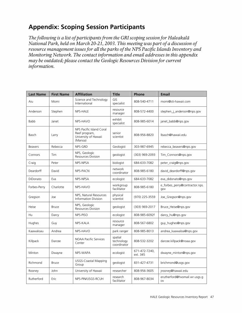
HALE Geologic Resources Inventory Report 47
Appendix: Scoping Session Participants
The following is a list of participants from the GRI scoping session for Haleakalā National Park, held on March 20-21, 2003. This meeting was part of a discussion of resource management issues for all the parks of the NPS Pacific Islands Inventory and Monitoring Network. The contact information and email addresses in this appendix may be outdated; please contact the Geologic Resources Division for current information.
Last Name First Name Affiliation Title Phone Email
Aiu Momi Science and Technology International
GIS specialist
808-540-4711 [email protected]
Anderson Stephen NPS-HALE resource manager
808-572-4400 [email protected]
Babb Janet NPS-HAVO exhibit specialist
808-985-6014 [email protected]
Basch Larry
NPS Pacific Island Coral Reef program, University of Hawaii (Manoa)
senior scientist
808-956-8820 [email protected]
Beavers Rebecca NPS-GRD Geologist 303-987-6945 [email protected]
Connors Tim NPS, Geologic Resources Division
geologist (303) 969-2093 [email protected]
Craig Peter NPS-NPSA biologist 684-633-7082 [email protected]
Deardorff David NPS-PACN network coordinator 808-985-6180 [email protected]
DiDonato Eva NPS-NPSA ecologist 684-633-7082 [email protected]
Forbes-Perry Charlotte NPS-HAVO workgroup facilitator
808-985-6180 [email protected]
Gregson Joe NPS, Natural Resources Information Division
physical scientist
(970) 225-3559 [email protected]
Heise Bruce NPS, Geologic Resources Division
geologist (303) 969-2017 [email protected]
Hu Darcy NPS-PISO ecologist 808-985-6092f [email protected]
Hughes Guy NPS-KALA resource manager 808-567-6802 [email protected]
Kaawaloau Andrea NPS-HAVO park ranger 808-985-8013 [email protected]
Killpack Darcee NOAA Pacific Services Center
spatial technology coordinator
808-532-3202 [email protected]
Minton Dwayne NPS-WAPA ecologist 671-472-7240, ext. 345 [email protected]
Richmond Bruce USGS-Coastal Mapping Group geologist 831-427-4731 [email protected]
Rooney John University of Hawaii researcher 808-956-3605 [email protected]
Rutherford Eric NPS-PIN/USGS-RCUH research facilitator
808-967-8034 [email protected]
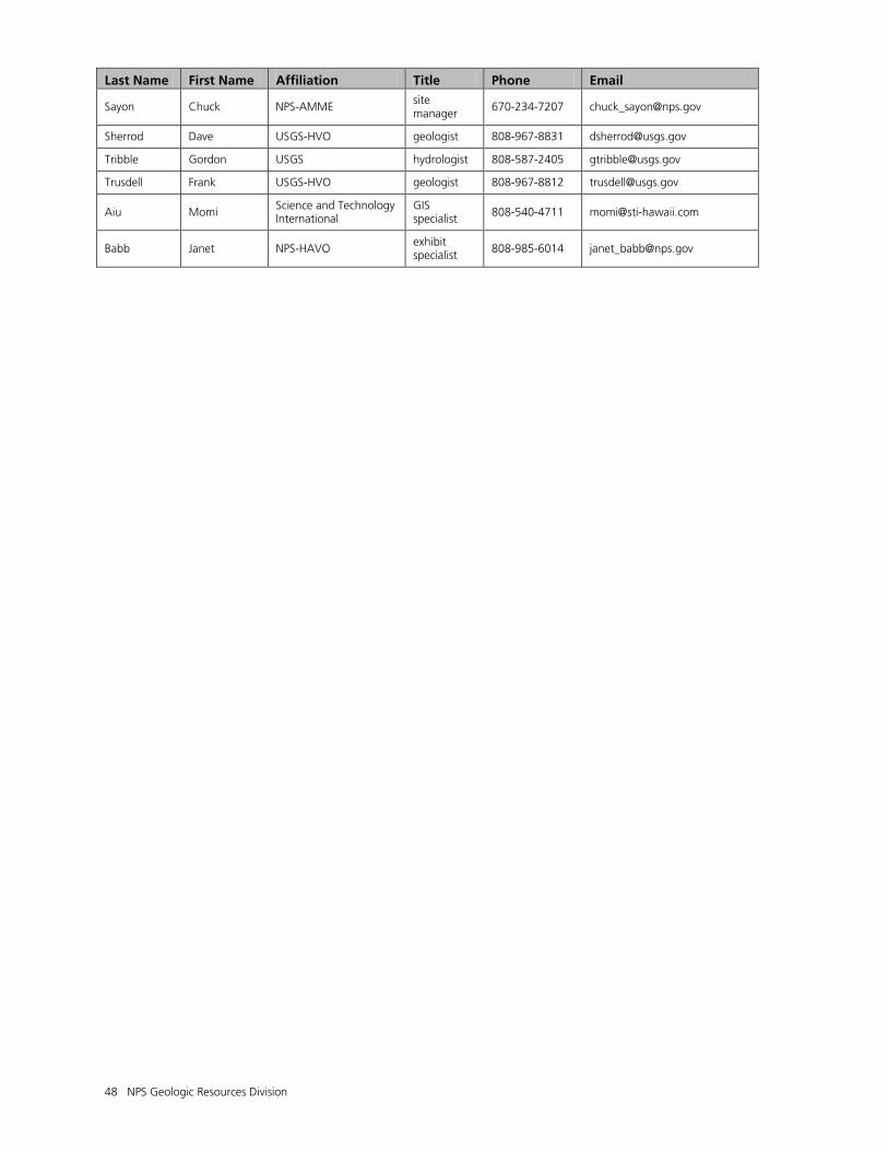
48 NPS Geologic Resources Division
Last Name First Name Affiliation Title Phone Email
Sayon Chuck NPS-AMME site manager
670-234-7207 [email protected]
Sherrod Dave USGS-HVO geologist 808-967-8831 [email protected]
Tribble Gordon USGS hydrologist 808-587-2405 [email protected]
Trusdell Frank USGS-HVO geologist 808-967-8812 [email protected]
Aiu Momi Science and Technology International
GIS specialist 808-540-4711 [email protected]
Babb Janet NPS-HAVO exhibit specialist 808-985-6014 [email protected]

The Department of the Interior protects and manages the nation’s natural resources and cultural heritage; provides scientific and other information about those resources; and honors its special responsibilities to American Indians, Alaska Natives, and affiliated Island Communities. NPS 162/110519, September 2011
National Park Service U.S. Department of the Interior
Natural Resource Stewardship and Science 1201 Oakridge Drive, Suite 150 Fort Collins, CO 80525 www.nature.nps.gov
EXPERIENCE YOUR AMERICA TM