geological mapping and petrogenesis of carving stone in ...€¦ · geological mapping and...
TRANSCRIPT
Geological mapping and petrogenesis of carving stone in the BelcherIslands, Nunavut
H.M. Steenkamp1, L. Timlick
2, R.A. Elgin
3and M. Akavak
3
1Canada-Nunavut Geoscience Office, Iqaluit, Nunavut, [email protected] of Geological Sciences, University of Manitoba, Winnipeg, Manitoba3Lands and Resources Department, Qikiqtani Inuit Association, Iqaluit, Nunavut
Steenkamp, H.M., Timlick, L., Elgin, R.A. and Akavak, M. 2016: Geological mapping and petrogenesis of carving stone in the Belcher Is-lands, Nunavut; in Summary of Activities 2016, Canada-Nunavut Geoscience Office, p. 121–130.
Abstract
Soft stone suitable for carving is a highly sought-after resource in Nunavut. The Qikiqtani Inuit Association (QIA) has de-veloped a program to assess carving stone reserves, site accessibility, and quarry safety, management and development intheir jurisdiction. A team of geologists from the QIA, Canada-Nunavut Geoscience Office and University of Manitoba vis-ited four carving stone sites on the Belcher Islands to conduct land surveying, geological mapping and petrogenetic evalua-tions of the rock being extracted as raw carving stone by local quarriers and carvers.
The carving stone at these sites is interpreted to comprise dolostone in sedimentary strata of the Costello and McLeary for-mations that have been intruded by diabasic to gabbroic rocks of the Haig suite and are locally contact metamorphosed.Within these areas, the dolostone beds are metamorphosed to a softer, more easily carved rock, likely due to the growth offine-grained talc and other metamorphic minerals. Other locations in the Belcher Islands where dolomitic sedimentarystrata are cut by Haig intrusive rocks also have the potential to host undiscovered carving stone reserves.
Résumé
La pierre tendre se prêtant à la sculpture est une ressource fort recherchée au Nunavut. La Qikiqtani Inuit Association (QIA)a mis en place un programme d’évaluation des réserves de pierre à sculpter, d’accessibilité aux sites et de pratiques desécurité, de gestion et de mise en valeur des carrières au sein de leur territoire. Une équipe formée de géologues issus de laQIA, du Bureau géoscientifique Canada-Nunavut et de l’Université du Manitoba a visité quatre emplacements de pierre àsculpter dans les îles Belcher afin d’y mener des travaux de levé, de cartographie géologique et d’évaluation pétrogénétiquede la roche extraite sous forme de pierre à sculpter à l’état brut par les exploitants de carrières et les sculpteurs.
Les géologues décrivent la pierre à sculpter à ces endroits comme étant de la dolomie gisant dans des strates sédimentairesdes formations de Costello et de McLeary, lesquelles sont pénétrées par des roches de la suite de Haig dont la compositionvarie de diabasique à gabbroïque et qui ont subi par endroits les effets du métamorphisme de contact. À ces endroits, lescouches de dolomie ont été métamorphisées et sont formées de roches plus tendres, et ainsi plus faciles à sculpter; cephénomène est attribuable à la croissance de talc à grain fin et d’autres minéraux métamorphiques. D’autres endroits dansles îles Belcher où des roches intrusives de la suite de Haig recoupent les couches sédimentaires formées de dolomiepourraient également receler des réserves encore non découvertes de pierre à sculpter.
Introduction
Soft stone suitable for decorative carving is a resource ofspecial significance in Nunavut. Under Section 19 of theNunavut Land Claims Agreement, an almost unrestrictedaccess to carving stone is guaranteed for Inuit peoples, pro-
viding a supply of raw stone to a growing industry of artisancarvers (Government of Canada, 1993). Under the guid-ance of the Government of Nunavut’s Department of Eco-nomic Development and Transportation (EDT), an inter-governmental document called Ukkusiksaqtarvik, The
Place Where We Find Stone: Carving Stone Action Plan
Summary of Activities 2016 121
This publication is also available, free of charge, as colour digital files in Adobe Acrobat® PDF format from the Canada-NunavutGeoscience Office website: http://cngo.ca/summary-of-activities/2016/.
(Nunavut Department of Economic Development andTransportation, 2007) was created. This document high-lights the importance of carving stone as a commodity inthe territory, and encourages improvement for access toquality carving stone across Nunavut by strengtheningtraditional quarrying methods and facilitating intercom-munity distribution.
The first step in Ukkusiksaqtarvik was to identify, locateand estimate resources at known, traditional and relativelynew carving stone localities. This was accomplished duringapproximately five years of community consultation andsite visits by the EDT’s Nunavut Carving Stone DepositEvaluation Project (NCSDEP; Beauregard et al., 2013;Beauregard and Ell, 2014, 2015). Although the NCSDEPidentified hundreds of potential sites across the territoryand concluded that sufficient good- to excellent-qualitycarving stone exists to supply the territory’s needs for hun-dreds of years, the challenges associated with co-ordin-ating the distribution of raw materials to communities andcarvers have yet to be addressed.
In recognition of the economic and cultural importance ofcarving stone in Nunavut and the logistical challenges as-sociated with implementation of the next steps of Ukkusik-
saqtarvik, the Qikiqtani Inuit Association (QIA) launchedtheir own evaluation project in the summer of 2016. Theproject targets the largest carving stone deposits on InuitOwned Lands in the Qikiqtaaluk Region, and provides thenecessary expertise to evaluate and assess resources at eachsite. It builds on the results of the NCSDEP, implementingits recommendations and addressing regional issues withregards to quarry development and the economic feasibilityof community-led expansions. The project will includequantifying the lifespan of sites based on surface andsubsurface deposits, and evaluating the work required tomake deposits accessible and free from dangers such asrock falls, flooding or wall collapse. The conclusion of thiswork will provide critical information for understandinglong-term resource availability in the region, which is nec-essary for further implementation of the Ukkusiksaqtarvik,and will ultimately enable local Inuit to utilize their resour-ces in a commercially viable and responsible manner.
Sites targeted by the QIA for resource and development as-sessment require geological mapping and interpretation,land surveying and site-accessibility evaluations. Geo-physical surveys (i.e., magnetic-anomaly mapping), pros-pecting and/or satellite-imagery analysis may also aid inthe full evaluation of resource viability at these sites. Thetop-priority sites include Kangiqsukutaaq (Korok Inlet,near Cape Dorset), Tatsituya and Tatsitui Tiniiniya (Aber-deen Bay, near Kimmirut), Opingivik Island (near Pang-nirtung), Qullisajaniavvik (near Sanikiluaq) and theKoonark deposit at Mary River (near Pond Inlet). Detailedgeological mapping has already been conducted at the
Kangiqsukutaaq (Steenkamp et al., 2014) and Opingivik(Steenkamp et al., 2015) sites.
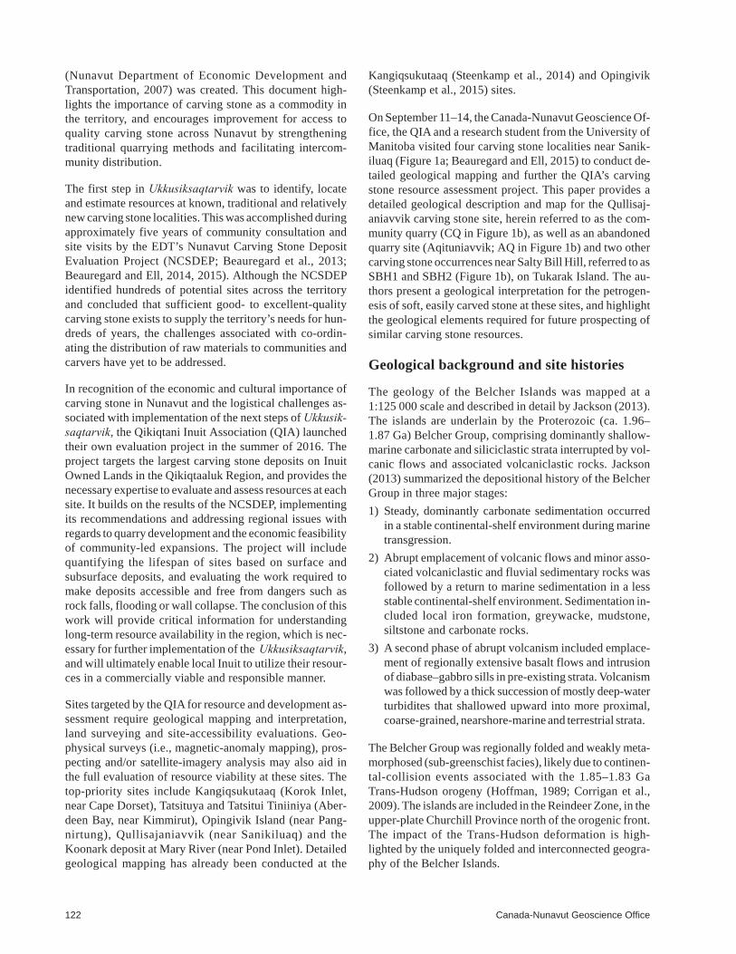
On September 11–14, the Canada-Nunavut Geoscience Of-fice, the QIA and a research student from the University ofManitoba visited four carving stone localities near Sanik-iluaq (Figure 1a; Beauregard and Ell, 2015) to conduct de-tailed geological mapping and further the QIA’s carvingstone resource assessment project. This paper provides adetailed geological description and map for the Qullisaj-aniavvik carving stone site, herein referred to as the com-munity quarry (CQ in Figure 1b), as well as an abandonedquarry site (Aqituniavvik; AQ in Figure 1b) and two othercarving stone occurrences near Salty Bill Hill, referred to asSBH1 and SBH2 (Figure 1b), on Tukarak Island. The au-thors present a geological interpretation for the petrogen-esis of soft, easily carved stone at these sites, and highlightthe geological elements required for future prospecting ofsimilar carving stone resources.
Geological background and site histories
The geology of the Belcher Islands was mapped at a1:125 000 scale and described in detail by Jackson (2013).The islands are underlain by the Proterozoic (ca. 1.96–1.87 Ga) Belcher Group, comprising dominantly shallow-marine carbonate and siliciclastic strata interrupted by vol-canic flows and associated volcaniclastic rocks. Jackson(2013) summarized the depositional history of the BelcherGroup in three major stages:
1) Steady, dominantly carbonate sedimentation occurredin a stable continental-shelf environment during marinetransgression.
2) Abrupt emplacement of volcanic flows and minor asso-ciated volcaniclastic and fluvial sedimentary rocks wasfollowed by a return to marine sedimentation in a lessstable continental-shelf environment. Sedimentation in-cluded local iron formation, greywacke, mudstone,siltstone and carbonate rocks.
3) A second phase of abrupt volcanism included emplace-ment of regionally extensive basalt flows and intrusionof diabase–gabbro sills in pre-existing strata. Volcanismwas followed by a thick succession of mostly deep-waterturbidites that shallowed upward into more proximal,coarse-grained, nearshore-marine and terrestrial strata.
The Belcher Group was regionally folded and weakly meta-morphosed (sub-greenschist facies), likely due to continen-tal-collision events associated with the 1.85–1.83 GaTrans-Hudson orogeny (Hoffman, 1989; Corrigan et al.,2009). The islands are included in the Reindeer Zone, in theupper-plate Churchill Province north of the orogenic front.The impact of the Trans-Hudson deformation is high-lighted by the uniquely folded and interconnected geogra-phy of the Belcher Islands.
122 Canada-Nunavut Geoscience Office
During the Pleistocene, the Belcher Islands were com-pletely covered by ice, and they are still rebounding at a rateof a few centimetres per year. It is likely that the islandswere completely inundated by the sea when the ice retreated,based on the presence of beach deposits atop the highesthills on Tukarak Island (Jackson, 2013).
The four carving stone sites visited during this study (Fig-ure 1b) were previously visited by Beauregard and Ell(2015), who completed carving stone quality assessmentsand preliminary resource-reserve calculations. The com-munity quarry, established in the 1970s, provides good- toexcellent-quality, grey, dark green and black carving stonethat can be extracted as blocks up to 1 m across and 40 cmthick and is soft enough to carve by hand. The stone is tradi-tionally quarried using the plugger-and-feather method,and excavated with a hammer and chisel or pry bar beforebeing transported approximately 50 km by snowmobile ormotorboat to the hamlet of Sanikiluaq. The communityquarry contains an estimated 30 000 tonnes of carving stonereserves, making it the second largest deposit in Nunavut(Beauregard and Ell, 2015).
The abandoned quarry yields a desirable light green stone,yet this is viewed by traditional carvers as lower qualitythan the stone from the community quarry. An area withinthis site was abandoned in the late 1990s when rocks fromthe outcrop above the quarry slid down to partially coverthe quarry access, raising concerns about the integrity ofthe remaining overhanging outcrop. The abandoned quarrysite is estimated to have 1000 tonnes of carving stone re-serves, as the desired horizon of carving stone continuesalong strike to the north of the blocked quarry access(Beauregard and Ell, 2015).
The two occurrences of carving stone near Salty Bill Hillhave not been traditionally quarried, as they are farther in-land and would require development of an ATV route totransport stone to the shore. However, they are estimated toeach hold <100 tonnes of good-quality carving stone(Beauregard and Ell, 2015).
Field observations
Community quarry (Qullisajaniavvik)
The community quarry area is underlain by steeply west-dipping sedimentary rocks of the Costello Formation that
Summary of Activities 2016 123
Figure 1: a) Location of the Belcher Islands in eastern Hudson Bay(Inuit-owned land in yellow) and location of study area (red box) inrelation to Sanikiluaq. b) Geology of the study area (adapted afterJackson, 2013) and locations of the community quarry (CQ), aban-doned quarry (AQ) and carving stone occurrences near Salty BillHill (SBH1 and SBH2), indicated by yellow stars. Thick black linesrepresent minor faults. Thin, continuous black lines represent ob-served geological contacts, and thin, dashed black lines representinterpreted geological contacts. Abbreviations: Fm./fm., Forma-tion/formation; l.m., lower member; m.m., middle member; u.m.,upper member; und., undivided.
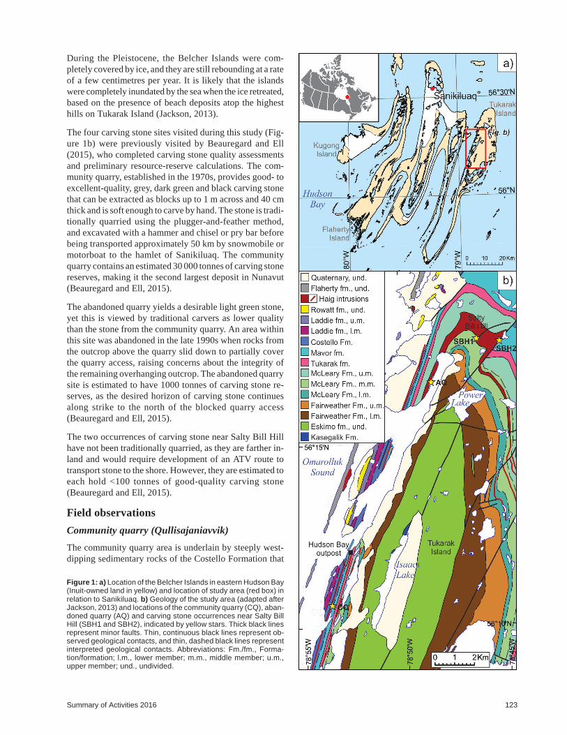
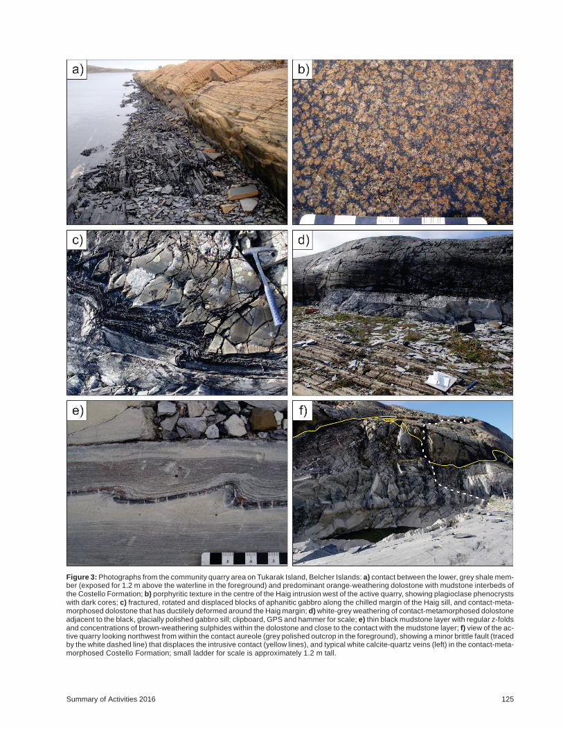
are injected by a diabasic to porphyritic gabbro of the Haigintrusive suite (Figure 2). Along the tideline of the smallbay in the southern part of the map area, the basal memberof the Costello Formation is well exposed and containsthinly laminated, dark grey shale. This is in conformablecontact with interbedded orange-weathering, fine-graineddolostone and grey-weathering, thin (<4 cm) mudstone(Figure 3a) that dominate the Costello Formation in thisarea. The dolostone exhibits wavy and low-angle crosslam-ination, and is medium grey on fresh surfaces. The mud-stone exhibits low-relief, asymmetric ripple crosslam-ination and is dark grey to black on fresh surfaces.Dolostone beds are locally boudinaged, likely an effect ofdewatering processes operating during regional compact-ion and diagenesis.
At the southern end of the map area, the Haig gabbro in-trudes the Costello Formation parallel to bedding as a sill.The sill thickens to the north, near the active quarry sites,and locally crosscuts the sedimentary bedding at obliqueangles. The interior parts of the Haig intrusion have a por-phyritic texture, with individual phenocrysts and agglom-erations of plagioclase in a black aphanitic matrix. West ofthe active quarry area, where the sill is thickest, plagioclasegrains appear to have dark cores (Figure 3b), which couldbe due to compositional zoning (suggesting two-stage crys-tallization from compositionally different magmas) or be adifferent mineral phase (possibly clinopyroxene) that actedas nucleation sites for later plagioclase crystallization.
Along the intrusive contact, the gabbro has 10–20 cm thick,aphanitic chilled margins that are regularly fractured per-pendicular to the contact. The fractured margin segmentsappear to be subsequently rotated 10–20°, possibly by con-tinued internal flow of magma during injection. Locally,the rotated margin segments of the gabbro have beenslightly offset. Where this occurs, the dolostone andmudstone layers are ductilely deformed and appear to infillthe offset spaces (Figure 3c), suggesting that the displace-ment may have occurred during later regional deformation.The interlayered dolostone and mudstone of the CostelloFormation, both stratigraphically below and above theHaig intrusion (to the east and west, respectively), is con-tact metamorphosed adjacent to the contact surface. Thewidth of the contact aureole appears to correlate with thethickness of the intrusion, ranging from 20–50 cm wherethe sill is 3–5 m thick in the southern part of the map area,up to 30 m in the community quarry area where the sill isthickest.
The contact-metamorphosed dolostone and mudstone havea bleached grey-white appearance on weathered surfaces
124 Canada-Nunavut Geoscience Office
Figure 2: Geology of the community quarry area on Tukarak Is-land, Belcher Islands. Abbreviations: Fm./fm., Formation/forma-tion; meta., metamorphosed; unmeta., unmetamorphosed.
Summary of Activities 2016 125
Figure 3: Photographs from the community quarry area on Tukarak Island, Belcher Islands: a) contact between the lower, grey shale mem-ber (exposed for 1.2 m above the waterline in the foreground) and predominant orange-weathering dolostone with mudstone interbeds ofthe Costello Formation; b) porphyritic texture in the centre of the Haig intrusion west of the active quarry, showing plagioclase phenocrystswith dark cores; c) fractured, rotated and displaced blocks of aphanitic gabbro along the chilled margin of the Haig sill, and contact-meta-morphosed dolostone that has ductilely deformed around the Haig margin; d) white-grey weathering of contact-metamorphosed dolostoneadjacent to the black, glacially polished gabbro sill; clipboard, GPS and hammer for scale; e) thin black mudstone layer with regular z-foldsand concentrations of brown-weathering sulphides within the dolostone and close to the contact with the mudstone layer; f) view of the ac-tive quarry looking northwest from within the contact aureole (grey polished outcrop in the foreground), showing a minor brittle fault (tracedby the white dashed line) that displaces the intrusive contact (yellow lines), and typical white calcite-quartz veins (left) in the contact-meta-morphosed Costello Formation; small ladder for scale is approximately 1.2 m tall.
(Figure 3d) and are light to medium grey on fresh surfaces.Although a grain-size change is not visibly apparent, freshsurfaces of the contact-metamorphosed dolostone exhibit asugary texture, as opposed to the flat, homogeneous freshface of an unmetamorphosed equivalent. The site wheremost of the quarrying for soft stone has so far been done iswhere the contact-metamorphic aureole in the dolostoneand mudstone is the broadest in the map area. The sedimen-tary rocks in this area likely experienced more consistent,prolonged heating due to the large volume of gabbroicmagma stratigraphically above, resulting in localizedgrowth of fine-grained metamorphic minerals, possibly in-cluding talc, serpentine, brucite, sericite or calcite. Due tothe fine-grained nature of these rocks, petrographic analy-sis is underway to ascertain their precise mineralogy.
A moderately to steeply northeast-dipping cleavage can beobserved where contact-metamorphosed beds are highlyfrost fractured. This fabric is associated with small, north-plunging z-folds that are most easily seen in the glaciallypolished mudstone layers near the active quarry (Fig-ure 3e). Locally, clusters of sulphide minerals concentrateat the margin between dolostone and mudstone layers, par-ticularly where the mudstone has been folded. These fea-tures likely developed during regional deformation of theBelcher Group rocks associated with the Trans-HudsonOrogen.
The Costello Formation and Haig intrusion both preserverelatively late minor veining and brittle faulting. Veins arecommon along the intrusive contact in pre-existing frac-tures, cut vertically and horizontally through the contact-metamorphosed sedimentary rocks (Figure 3f), and occuras a narrow concentrated network that follows bedding inthe dolostone west of the intrusion and contact-metamor-phic aureole. The veins typically contain varying propor-tions of quartz and calcite, as well as local dolomite andfine-grained talc. The quartz is massive and white in theunmetamorphosed dolostone and occurs as isolated clus-ters of crystals that are translucent to white, euhedral tosubhedral and surrounded by calcite in the contact-meta-morphosed areas. In one locality along the intrusive contactmargin, thin veins are rimmed by fine-grained talc crystalsand infilled by elongated quartz, both being oriented per-pendicular to the vein walls and therefore suggesting thatcrystallization was synchronous with progressive veinopening.
Several late brittle faults are present in the map area, basedon minor offsets in the intrusive contact margin and elon-gate, aligned concentrations of highly fractured gabbro thatis more easily traced where the faults intersect the walls ofthe quarry (Figure 3f). Displacement along any of thesefaults was likely no more than 5 m in an oblique-slip mo-tion, as indicated by moderately plunging slickensides ofrecrystallized calcite and rare actinolite.
Other carving stone sites
North of the community quarry, three other carving stonelocalities were visited to evaluate their geological relation-ships and petrogenesis, as well as their potential for holdingadditional carving stone reserves for the territory. Thesesites are the abandoned quarry, which was used as a carvingstone source prior to increased use of the communityquarry, and two carving stone showings near Salty Bill Hill(Figure 1b). Based on their locations, all three sites appearto involve sedimentary rocks from the middle member ofthe McLeary Formation that are closely associated withHaig intrusions (Jackson, 2013).
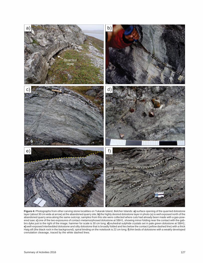
The abandoned quarry site is located approximately 50 mup a steep, grassy hill from the tideline. The lowest outcropexposure consists of steeply west-dipping, interbeddeddolostone and thinly laminated argillite. A 1.5–2 m thick,pink and grey, crossbedded sandstone layer interrupts theinterbedded dolostone and argillite about 4 m up the out-crop. The sedimentary rocks are intruded by a thick Haigsill approximately 6 m up from the sandstone bed. Similarto the community quarry site, it appears as though the heatfrom the intrusion has contact metamorphosed the outcrop-ping sedimentary rocks below it, and possibly farther downthe stratigraphy. Common calcite- and quartz-bearingveins, concentrated mostly in the dolostone and argillite,are also similar to those seen at the community quarry. Thedolostone is a light greenish grey and the argillite laminaeare buff, grey, dark grey and black.
Carving stone has been harvested primarily from a discrete,30–40 cm thick layer of contact-metamorphosed, lightgreen dolostone that runs along the base of the outcrop. Theextraction of this particular layer has resulted in an 8–10 mdeep and 20 m long gap that dips down into the outcrop(Figure 4a). Rusted pry bars and other tools can still be seenat the bottom of the worked layer. Boulders of dolostonehave fallen over parts of the gap and, because of this, peopleno longer attempt to quarry from within it. The desiredlayer of dolostone continues along strike and reappears atground level farther to the north, where there is ample evi-dence of past and recent carving stone harvesting (Fig-ure 4b).
The two carving stone showings near Salty Bill Hill werepreviously described by Beauregard and Ell (2014), andwere visited only briefly this year to conduct a follow-upevaluation of the potential for new carving stone reserves.The first site visited, SBH1 (Figure 1b), comprises two rel-atively small outcrops (measuring roughly 2 by 2 by 3 meach; Figure 4c) of laminated dolostone adjacent to a north-trending, 4 m wide diabase dyke. The bedding appears tofold with proximity to the dyke, and the outcrop becomesless competent and more frost fractured with distance fromthe dyke. These two outcrops are the only surface expo-sures of potential carving stone in the vicinity of the dyke,
126 Canada-Nunavut Geoscience Office
Summary of Activities 2016 127
Figure 4: Photographs from other carving stone localities on Tukarak Island, Belcher Islands: a) surface opening of the quarried dolostonelayer (about 30 cm wide at arrow) at the abandoned quarry site; b) the highly desired dolostone layer in photo (a) is well exposed north of theabandoned quarry area along the same outcrop; samples from this site were collected where cuts had already been made with a gas-pow-ered saw; c) one of the two exposures of contact-metamorphosed dolostone at SBH1, showing minor folding near the contact with the gab-bro dyke just to the right of the image; hammer for scale is 30 cm long; d) euhedral sulphide crystals set in pale green dolostone at SBH1;e) well-exposed interbedded dolostone and silty dolostone that is broadly folded and lies below the contact (yellow dashed line) with a thickHaig sill (the black rock in the background); spiral binding on the notebook is 22 cm long; f) thin beds of dolostone with a weakly developedcrenulation cleavage, traced by the white dashed lines.
but there may be additional contact-metamorphosed stonebeneath the overburden along the dyke margins.
The contact-metamorphosed dolostone is light green topale grey and locally contains euhedral sulphide crystals(Figure 4d). Calcite and quartz veins in the dolostone are<1 cm wide and cut the bedding obliquely; in the diabasedyke, they are up to 10 cm wide and also contain sulphideminerals, together with minor malachite and azurite.
The second site visited, SBH2 (Figure 1b), consists of sev-eral pavement-style outcrops of interbedded dolostone andsilty dolostone directly below the base of a large, exten-sively exposed Haig sill (Figure 4e) that forms the top ofSalty Bill Hill. The dolostone bedding is 10–25 cm thickand broadly folded. A locally developed, weak crenulationcleavage (Figure 4f) is a reflection of this outcrop’s posi-tion at the hinge of the Tukarak antiform (Jackson, 2013).Dolostone beds are light green on fresh surfaces and locallycontain rare, euhedral sulphide minerals. The thin, siltydolostone interbeds are light grey to white and containlaminae with elongate mats of fine-grained talc.
Geological interpretations
The four carving stone sites visited during this study havecommon geological relationships that have allowed for thegenesis of soft, easily carved stone. Each site consists ofdolostone beds that have been contact metamorphosed bythe Haig intrusive complex. Dolostone within the contactaureoles appears to contain new metamorphic minerals thatsoften the rock, making it easier to carve. One of manymetamorphic reactions that likely occurred in the sedimen-tary rocks during the intrusion and cooling of the Haig sillsis
dolomite silica talc calcite
3 CaMg(CO3)2 + 4 SiO2 + H2O → Mg3Si4O10(OH)2 + 3 CaCO3 + CO2
where the silica may have been sourced partly from the in-trusion and partly from the original sedimentary rocks.
Also common to all sites is the relationship between thethickness of the intrusive sill and the resultant thickness ofthe contact aureole. As documented in the communityquarry map area, the extent of the contact-metamorphic au-reole also expands where the Haig sill thickens. At the othersites, the tops of the Haig sills are partly eroded, but out-crops still expose a thickness of at least 50 m in places. Alsonotable is that, where both a top and a bottom contact aure-ole can be observed (i.e., around the community quarrymap area), the aureole below the sill tends to be thicker thanthat above the sill. It is possible that, after intrusion, the sillsmay have acted as insulating layers while still progres-sively cooling. Therefore, rocks below the intrusions mayhave experienced prolonged heating, allowing more timeand energy for the growth of new metamorphic minerals.
Given these observations and interpretations, the petrogen-esis of the soft, easily carved stone preferred by local carv-ers required the intrusion of a thick sill or dyke of gabbroicHaig magma through dolostone beds in the Belcher Groupsedimentary strata, followed by persistent, slow cooling ofthe host strata to allow for the growth of metamorphic min-erals. Further prospecting for new carving stone depositsshould apply these geological elements and focus particu-larly around the basal contact surfaces of sills.
Economic considerations
There are numerous locations where the key geological ele-ments identified above exist in the Belcher Islands. Thus,the potential for finding new sites that contain good- to ex-cellent-quality carving stone derived from contact-meta-morphosed dolostone is considerable. In terms of access,the Belcher Islands are unique in Nunavut: the land is rela-tively low-lying, nearly completely accessible with an ATVor boat in the summer and fully accessible by snowmobilein the winter, and bedrock outcrop is extensive. The com-munity quarry and abandoned quarry sites are very close totidewater, but the Salty Bill Hill sites would require trans-portation of harvested carving stone for a distance of 2–4 km over uneven tundra to reach a section of the shorelinethat is accessible by boat.
Aside from carving stone resources, the Belcher Islandshave potential for base metals, such as copper and iron.Many of the sedimentary formations naturally contain dis-seminated metals, and these appear to be concentrated andrecrystallized where associated with the Haig intrusiverocks, and in calcite-quartz veins such as those observed atthe SBH1 site.
Finally, the Belcher Islands host a wide variety of Protero-zoic sedimentary and volcanic igneous rocks, and preservemany remarkable geological features such as pillow basalts,volcaniclastic-flow deposits, stromatolite reefs and bandediron formations, to name a few. Other examples of thesefeatures from the same geological timeframe that are sominimally deformed or metamorphosed are rare through-out the rest of the world. The Belcher Islands could prove tobe a significant location for future discoveries regardingEarth’s geological history, and is an excellent location forgeotourism and geological field schools.
Acknowledgments
The authors thank the community of Sanikiluaq for their in-terest and support for this project. They are particularlygrateful for the expert transportation, guidance and assis-tance in the field from master carver Jimmy Iqaluq, his sonJack Iqaluq and the rest of the Iqaluq family. NunavutMLA, Alan Rumbolt, and his family, Garry and Daisy, arethanked for providing accommodations in Sanikiluaq.Mike Beauregard is thanked for his guidance and encour-
128 Canada-Nunavut Geoscience Office
agement for furthering work on the Belcher Island carvingstone sites; he has invested a great deal of time and effort inthe NCSDEP and continues to advocate for carving stoneresearch in Nunavut. The Belcher Islands work was fundedby the Community Readiness and Opportunities Planningprogram of the Canadian Northern Economic Develop-ment Agency, and the Qikiqtani Inuit Association. Athoughtful and thorough review of this paper was providedby David Mate.
Natural Resources Canada, Earth Sciences Sector contri-bution 20160224
References
Beauregard, M.A. and Ell, J. 2015: Nunavut Carving Stone De-posit Evaluation Program: 2013 and 2014 fieldwork in theKitikmeot Region, Belcher Islands, Hall Peninsula and Re-pulse Bay, Nunavut; in Summary of Activities 2014, Can-ada-Nunavut Geoscience Office, p. 163–174.
Beauregard, M. and Ell, J. 2015: Nunavut Carving Stone DepositEvaluation Program: 2015 fieldwork at Rankin Inlet, Cum-berland Sound and Arctic Bay, Nunavut; in Summary of Ac-tivities 2015, Canada-Nunavut Geoscience Office, p. 183–192.
Beauregard, M., Ell, J., Pikor, R. and Ham, L. 2013: NunavutCarving Stone Evaluation Program (2010–2013), third yearresults; in Summary of Activities 2012, Canada-NunavutGeoscience Office, p. 151–162.
Corrigan, D., Pehrsson, S., Wodicka, N. and De Kemp, E. 2009:The Palaeoproterozoic Trans-Hudson Orogen: a prototypeof modern accretionary processes; in Ancient Orogens andModern Analogues, J.B. Murphy, J.D. Keppie and A.J.
Hynes (ed.), The Geological Society of London, SpecialPublications, vol. 327, p. 457–479.
Government of Canada 1993 (amendments included in 2009):Agreement Between the Inuit of the Nunavut SettlementArea and Her Majesty the Queen in Right of Canada(Nunavut Land Claims Act); Indian and Northern AffairsCanada, Article 19, Title to Inuit Owned Lands: Part 9,Rights to Carving Stone; Government of Canada, p. 149–150.
Nunavut Department of Economic Development and Transporta-tion 2007: Ukkusiksaqtarvik – the place where we findstone: carving stone supply action plan; Nunavut Depart-ment of Economic Development and Transportation, 12 p.,URL <http://www.gov.nu.ca/sites/default/files/carving_stone_action_plan_english.pdf> [October 2016].
Hoffman, P. 1989: Precambrian geology and tectonic history ofNorth America; in Geology of North America – An Over-view, A.W. Bally and A.R. Palmer (ed.), Geological Societyof America, Chapter 16, p. 447–512.
Jackson, G.D. 2013: Geology, Belcher Islands, Nunavut; Geologi-cal Survey of Canada, Open File 4923, 159 p. and map at1:125 000 scale. doi:10.4095/292434
Steenkamp, H.M., Pizzo-Lyall, M., Wallace, C.J., Beauregard,M.A. and Dyck, B.J. 2014: Geology, history and site-man-agement planning of the Kangiqsukutaaq carving stonequarry, southern Baffin Island, Nunavut; in Summary of Ac-tivities 2013, Canada-Nunavut Geoscience Office, p. 193–200.
Steenkamp, H.M., Beauregard, M.A. and Mate, D.J. 2015: Carv-ing stone and mineral potential of the Opingivik deposit,southern Baffin Island, Nunavut; in Summary of Activities2014, Canada-Nunavut Geoscience Office, p. 153–162.
Summary of Activities 2016 129

130 Canada-Nunavut Geoscience Office