geological processes and sedimentation rates of wind · pdf filegeological processes and...
TRANSCRIPT

Geological Processes and Sedimentation Rates of Wind-Tidal Flats, Laguna Madre, Texas
Robert A. Morton1 and Charles W. Holmes2
1U.S. Geological Survey, 10100 Burnet Rd., Bldg. 130, Austin, Texas 78758
2Environchron, 9103 64th Ave. E., Bradenton, Florida 34202
ABSTRACT
Coastal flats worldwide that are periodically exposed to arid climates and periodi-cally flooded by marine waters are unique depositional environments because they re-ceive sediments surficially and interstitially from both land and sea. The wind-tidal flats bordering Laguna Madre, Texas, which fit this unique category, are modified by eolian processes when subaerially exposed, and by wave and current processes when sub-merged. Floodwater is derived from the lagoon and driven onto the flats by strong and persistent winds during the passage of cold fronts and tropical cyclones. Low surface gradients of the flats prevent rapid drainage and promote seawater evaporation. The depositional products of these processes are interbedded and interlaminated sand, mud, marine shells, algal mats, and evaporites. This assemblage of sediments is geologically diagnostic evidence for intertidal marine deposition and the same assemblage of sedi-ments have been reported for modern marginal-marine flats in the Middle East.
The wind-tidal flat surface at Laguna Madre is constantly changing. However, the net effect of natural changes during the past century is either negligible or the changes occur at such a slow rate that they are almost imperceptible. Sediments are repeatedly added to and removed from the surface of the flats in minor increments and in different areas at different times. Preservation potential is enhanced at a particular site by the development of thick mats of blue-green algae.
The 14C ages of buried algal mats yield average long-term (centuries to millennia) sedimentation rates for the wind-tidal flats that range from 0.13 to 0.96 mm/yr and aver-age 0.57 mm/yr. The 210Pb profiles yield average short-term (150 yr) sedimentation rates that are an order of magnitude higher, ranging from 0.7 to 8.3 mm/yr and averaging 2.9 mm/yr. The minimum present rate of relative sea-level rise in Laguna Madre (3.4 mm/yr) exceeds the historical sedimentation rates for most of the flats. If future sea-level rise is faster than the rates of aggradation, then the wind-tidal flats will progressively become more frequently flooded and will eventually become permanently submerged.
INTRODUCTION Broad, barren coastal flats that are periodically exposed and periodically flooded by marine water are com-
mon where the climate is hot and relatively dry, the tidal range is low, strong winds drive seawater onshore, and there are no large streams or rivers emptying into the coastal waters. The conditions that promote periodic flood-ing of coastal flats by saline water are met not only in the Persian Gulf (Kinsman, 1969; Kinsman and Park, 1976; Patterson and Kinsman, 1981), Red Sea (Friedman et al., 1973), and eastern Mediterranean Sea (Levy, 1977), but
Morton, R. A., and C. W. Holmes, 2009, Geological processes and sedimentation rates of wind-tidal flats, Laguna Madre, Texas: Gulf Coast Association of Geological Societies Transactions, v. 59, p. 519-538.
519

Morton and Holmes
also in south Texas (Fisk, 1959; Miller, 1975). All the marginal-marine coastal flats in the Middle East and in south Texas are either barren or covered by mats of blue-green algae, and they contain authigenic sulfate and carbonate minerals that form from the evaporation of seawater. Alternating layers of sand, mud, algal mats, and evaporites are diagnostic sedimentary components of these coastal-flat environments.
The wind-tidal flats of Laguna Madre, Texas (Figs. 1 and 2), have been the focus of several geological in-vestigations because they represent an anomaly compared to other coastal depositional environments. The Texas flats are located between a barrier island (Padre Island) to the east and a vast complex of sand dunes (eolian plain) forming uplands to the west. Margins of the flats and eolian plain are also aligned with the predominant southeasterly wind direction, and they coincide with the ocean-shoreline embayment where average northerly-directed and southerly-directed alongshore currents converge near 27°N latitude in the western Gulf of Mexico.
The primary objectives of this study were to investigate the geologic history of the Laguna Madre flats over the past few hundred yr, to determine if significant surficial changes had occurred in and around the flats since the late 1800s, and to provide data for predicting the future condition of the flats, considering anticipated rates of sea-level rise. These tasks required understanding the dominant physical processes responsible for constructing the flats, examining the sedimentary sequences beneath the flats, estimating the time-averaged and most recent rates of sedimentation, and interpreting the geological significance of the results. To achieve the study objec-tives, we (1) examined historical documents, (2) made aerial and ground field observations, (3) collected, de-scribed, and sampled sediment cores, (4) analyzed physical and chemical properties of the sediments, and (5) interpreted the integrated data.
Figure 1. Map of the Texas coast, showing location of the wind-tidal flats of Laguna Madre near 27°N latitude and locations of Port Isabel and Rockport where interior tide gauges are located.
520
Geological Processes and Sedimentation Rates of Wind-Tidal Flats, Laguna Madre, Texas
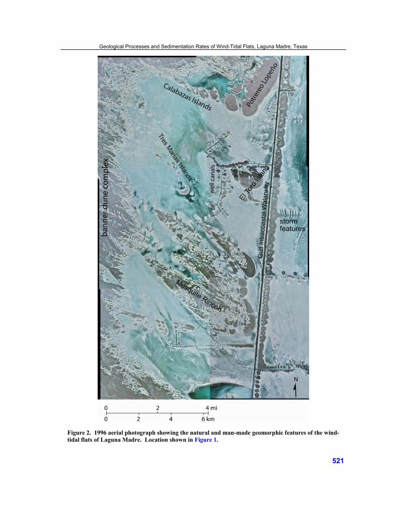
Figure 2. 1996 aerial photograph showing the natural and man-made geomorphic features of the wind-tidal flats of Laguna Madre. Location shown in Figure 1.
521

DATA SOURCES AND METHODS
Historical Records and Field Operations The U.S. Coast Survey prepared the oldest reliable topographic map of the wind-tidal flats of Laguna Madre
(Fig. 3). This map meets federal accuracy standards, so it can be compared with recent photographic images and orthophoto maps to determine if significant geomorphic changes have occurred on the flats during the past 130 yr. Ten sets of aerial photographs taken between 1937 and 2005 also were examined and compared to evaluate the stability of features on and around the flats. A topographic contour map prepared in 1948 by the Humble Oil and Refining Company (Fisk, 1959) was used to estimate elevations at the coring sites (Fig. 4). The relative dif-ferences in elevations across the flats probably have not changed significantly since the 1948 survey.
Aerial reconnaissance and ground observations showed that the degree of algal-mat development at a par-ticular site could be broadly categorized as dense, sparse, or absent (non-algal). Coring sites were selected to represent the major physiographic subdivisions of the flats and to sample each category of algal-mat density at several different locations. Geographic coordinates of the coring sites were determined by Global Positioning System surveys conducted by the Texas General Land Office.
Both push-core and vibracore (Lanesky et al., 1979) techniques were used to penetrate and retrieve uncon-solidated sediments to a depth of about 2 m. The core barrels consisted of standard 7.5 cm diameter aluminum irrigation pipes. Each core was cut into 1 m sections, and each section was split lengthwise (Fig. 5). Two con-tinuous sediment cores were obtained at each of the 13 core sites. Each replicate core was located within 5 m of the first core taken at a site. The replicate cores were collected to test the repeatability of the sampling method, to provide ample material for the physical and chemical analyses, and to offer a choice of the core that was selected for extensive physical and chemical analyses. One half of each core was cleaned, photographed, and described in detail. The core descriptions and photographs provided a basis for identifying the predominant sedimentary fa-cies and for selecting stratigraphic units to sample for isotopic analysis.
At several coring sites, a 1 m deep trench was excavated, cleaned, and photographed. The trench photo-graphs provided an independent record of the sediment composition and lateral continuity of laminations in the wind-tidal-flat deposits. Trenches avoid the potential sediment deformation caused by the coring process, but vehicles in transit or other surface activities before trench excavation could deform the sediments.
Nearly all cores taken in unconsolidated sediments undergo some compaction that typically ranges between 10% and 40% (Molnar and Smith, 1993; Morton and White, 1997). The percent compaction for the cores from the Laguna Madre wind-tidal flats is well within this range. The amount of compaction normally depends on the type of material being cored. Sand with abundant air pockets, such as the sponge-cake texture, or soft mud with high water content, are easily compacted. In contrast, well-sorted sand is not easily compacted. Most of the wind-tidal-flat cores penetrated sediments that are laminated, and the laminations are composed of layers that are alternately more compactable (mud or algal mats) and less compactable (sand or evaporites). Detailed correlation of the replicate cores at each site reveals the zones of strata that have undergone the most compaction. Correla-tion of laminations in the cores with those observed in the trenches also helps identify the zones that have under-gone compaction.
Magnitudes of core shortening and total core length were the primary considerations used to select a core for physical and chemical analyses. Minimizing the amount of shortening is important because it affects the relative depths of the laminations and the data derived from those laminations. Core shortening also causes calculated sedimentation rates to be lower than the actual rates because the strata are closer together. Core depths can be corrected for shortening if measurements are made during the coring operation (Morton and White, 1997). Most of the cores used for the detailed analyses were shortened less than 15%.
Laboratory Analyses
Chronology of the wind-tidal flats was measured using 210Pb and 14C isotopic analyses of core samples. For
the 210Pb analysis, cores were sampled at 1 cm intervals for the uppermost 15 cm, then at 5 cm increments to the bottom of each core. Holmes et al. (2001) presented a detailed description of analytical methods. Briefly, a ho-mogenized wet sample was placed in a clean, weighed porcelain evaporating dish, dried at 40ºC, cooled, and
Morton and Holmes
522

Figure 3. Topographic maps T-1677 and T-1678 of central Laguna Madre surveyed by the U.S. Coast Survey in 1879-81 showing the natural geomorphic features of the wind-tidal flats.
Geological Processes and Sedimentation Rates of Wind-Tidal Flats, Laguna Madre, Texas
523

Figure 4. Locations of sediment cores collected from the wind-tidal flats of Laguna Madre, Texas, and associated average sedimentation rates from the 210Pb analyses using the constant rate of supply (CRS) and constant initial concentration (CIC) models.
Morton and Holmes
524
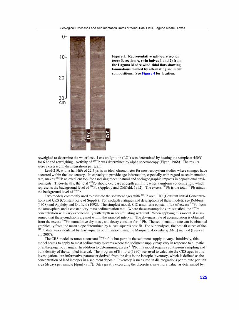
Figure 5. Representative split-core section (core 3, section A, twin halves 1 and 2) from the Laguna Madre wind-tidal flats showing laminations formed by alternating sediment compositions. See Figure 4 for location.
reweighed to determine the water loss. Loss on Ignition (LOI) was determined by heating the sample at 450ºC for 6 hr and reweighing. Activity of 210Pb was determined by alpha spectroscopy (Flynn, 1968). The results were expressed in disintegrations per gram.
Lead-210, with a half-life of 22.3 yr, is an ideal chronometer for most ecosystem studies where changes have occurred within the last century. Its capacity to provide age information, especially with regard to sedimentation rate, makes 210Pb an excellent tool for assessing recent natural and sociogeographic impacts in depositional envi-ronments. Theoretically, the total 210Pb should decrease at depth until it reaches a uniform concentration, which represents the background level of 210Pb (Appleby and Oldfield, 1992). The excess 210Pb is the total 210Pb minus the background level of 210Pb.
Two models commonly used to estimate the sediment ages with 210Pb are: CIC (Constant Initial Concentra-tion) and CRS (Constant Rate of Supply). For in-depth critiques and descriptions of these models, see Robbins (1978) and Appleby and Oldfield (1992). The simplest model, CIC assumes a constant flux of excess 210Pb from the atmosphere and a constant dry-mass sedimentation rate. Where these assumptions are satisfied, the 210Pb concentration will vary exponentially with depth in accumulating sediment. When applying this model, it is as-sumed that these conditions are met within the sampled interval. The dry-mass rate of accumulation is obtained from the excess 210Pb, cumulative dry mass, and decay constant for 210Pb. The sedimentation rate can be obtained graphically from the mean slope determined by a least-squares best fit. For our analyses, the best-fit curve of the 210Pb data was calculated by least-squares optimization using the Marquardt-Levenberg (M-L) method (Press et al., 2007).
The CRS model assumes a constant 210Pb flux but permits the sediment supply to vary. Intuitively, this model seems to apply to most sedimentary systems where the sediment supply may vary in response to climatic or anthropogenic changes. In addition to determining excess 210Pb, this model requires contiguous sampling and bulk density of the sampled interval. The program of Binford (1990) was used to calculate the CRS ages in this investigation. An informative parameter derived from the data is the isotopic inventory, which is defined as the concentration of lead isotopes in a sediment deposit. Inventory is measured in disintegrations per minute per unit area (decays per minute [dpm] / cm2). Sites greatly exceeding the theoretical inventory value, as determined by
Geological Processes and Sedimentation Rates of Wind-Tidal Flats, Laguna Madre, Texas
525
the flux, indicate that the sediment acquired additional lead during transport. Baskaran et al. (1993) estimated that the atmospheric flux of 210Pb at Galveston and College Station, Texas, was 1 dpm/cm2, which equates to a value of 32 dpm/cm2/yr. They also demonstrated that most of this flux occurred during rain events. Because average precipitation in the Galveston region is 130 cm/yr, and average rainfall in the Corpus Christi region is 75 cm/yr, the flux of 210Pb in the Laguna Madre region is estimated to be about 60% of that at Galveston, or about 20 dpm/cm2/yr. Core sites with inventories that exceed the theoretical value, as determined by the flux, indicate that the sediment has been focused into that site from the surrounding region, whereas sites with less than the theoretical value indicate missing sediment as a result of either periods of non-deposition or erosion.
For the 14C analysis, selected algal-mat samples were cleaned of carbonate material and submitted to Beta Analytic Inc. The 14C analysis was determined by the Accelerator Mass Spectrometry (AMS) method, which required measuring the stable-carbon isotopic ratio (δ13C). Reported results contained both δ13C and the conven-tional radiocarbon age (CRA), which is the age corrected for carbon isotopic fractionation as established by the δ13C. Calibrated ages were then determined by the OxCal 5.0.1 program using the Marine04 correction (Hughen et al., 2004).
X-radiographs of the core half selected for isotopic analysis were made by a commercial lab in Denver, Colorado. Organic analyses (carbon and nitrogen isotopes and fatty acids) were conducted by Dr. Pat Parker at the Department of Marine Studies, University of Texas at Austin, and chemical, textural, and x-ray diffraction (XRD) analyses were conducted by the Bureau of Economic Geology, University of Texas at Austin. The com-mon siliciclastic and authigenic minerals were identified using a binocular microscope and XRD techniques. Eleven representative samples from eight different cores were selected for XRD analysis based on appearance, crystal form, and sample depth.
GEOLOGICAL SETTING
Climate and Physical Processes The wind-tidal flats of Laguna Madre are in a semi-arid climate zone, wherein annual average evapotranspi-
ration normally exceeds precipitation (Bomar, 1995). The deficit in rainfall has a profound influence on plant assemblages, physical processes, and landforms of the region. Coastal waters historically have been hypersaline because average annual temperatures are high, evaporation is high, rainfall is low, and freshwater inflow to the lagoon is low. However, salinities in Laguna Madre have not been abnormally high since the late 1940s, when construction of the Gulf Intracoastal Waterway (GIWW) connected northern and southern Laguna Madre (Fig. 1). Opening Mansfield Channel in the early 1960s also increased water circulation between the lagoon and the Gulf of Mexico and moderated salinity fluctuations (Hansen, 1960).
Large dune fields and wind-tidal flats dominate the landscape surrounding Laguna Madre. Every few dec-ades, prolonged droughts lower the water table, reduce the internal moisture of the sediments, weaken or kill the stabilizing vegetation, and accelerate onshore eolian transport of sand.
Wind is responsible for shaping the south Texas coastal plain and controlling erosion and deposition on the wind-tidal flats and in other coastal environments. The predominant southeasterly onshore winds generally do not reach high velocities, but they persist from spring through fall. In contrast, northerly winds associated with the passage of winter cold fronts are strong but brief; however, their total energy dissipated at the coast is less than that of the predominant southeasterly winds (Price, 1958).
Water-Level Fluctuations Astronomical tides in Laguna Madre are mixed (diurnal and semi-diurnal) and extremely small, ranging
from 0 to 30 cm (Gill et al., 1995). The absence of substantial tidal influence on water levels in Laguna Madre is attributed to the low tidal range in the western Gulf of Mexico, the large area and small number of tidal inlets intersecting the lagoon, and the long distances from inlets to the center of the lagoon. Meteorological forces (wind speed and direction, barometric pressure) largely control water-level fluctuations near the wind-tidal flats
Morton and Holmes
526

and the astronomical tides explain only a few percent of the water-level variability (Fisk, 1959; Gill et al., 1995). The flats have such low relief that wind is capable of pushing water out of the lagoon and up onto the flats. Field observations and daily monitoring (Fisk, 1959) showed that the flats are inundated by non-channel sheet flow.
Both winter storms and tropical cyclones can rapidly change water levels in Laguna Madre and generate moderately high waves and strong currents that erode and transport small volumes of sediment. Cold fronts with associated north winds cross the Texas coast about every six days throughout the winter. Because of this frontal activity, several strong winter storms occur each year. Before a cold front passes the coast, strong winds blow onshore from the southeast in response to the low-pressure system that is farther inland. Strong onshore wind drives water onto the southern part of the flats and off the northern part of the flats (Fisk, 1959). After the frontal boundary passes the coast and moves over the Gulf of Mexico, the wind changes direction and blows from the north, driving water onto the northern and off the southern part of the flats. A hurricane crosses the Texas coast about once every three yr, but the probability of a major hurricane striking at any particular site is much lower and on the order of once every 10 to 12 yr (Simpson and Lawrence, 1971). The climate and geographic setting of Laguna Madre ensures that it has been influenced by several hundred hurricanes since it was formed several thou-sand yr ago. Hurricanes flood the flats and generate high-velocity, wind-driven currents that locally erode and deposit sand on the flats (Fig. 2).
Flooding frequency of the flats generally decreases to the west and northwest because of surface gradient and orientation with respect to the lagoon and predominant wind directions. This means that core sites near the western margins (core sites 4, 5, 6, and 9) are less frequently flooded, whereas core sites near the open lagoon (core sites 1, 12, and 13) are more frequently flooded.
Relative Sea-Level Changes Tide-gauge records in interior coastal waters of south Texas all show interannual and decadal sea-level
variations that coincide with droughts and periods of abnormally high rainfall. The relative rise in sea level (Fig. 6) currently averages from 3.4 mm/yr at Port Isabel, which is the lowest for the entire Texas coast, to 4.6 mm/yr at Rockport (Zervas, 2001). The rate of relative sea-level rise in Laguna Madre (3.4 mm/yr) is about twice as fast as the eustatic rise of 1.8 mm/yr for the past century (Douglas, 2001) or nearly comparable to the average global eustatic rate (3.1 mm/yr) between 1993 and 2003 (Intergovernmental Panel on Climate Change, 2007).
When examined for temporal trends, tide gauges within or near Laguna Madre reveal significant increases in water level beginning in the early 1960s (Fig. 6). Some of the historical relative rise in sea level is due to subsi-dence (Swanson and Thurlow, 1973) caused by sediment compaction, with additional regional contributions from subsurface-fluid withdrawal (Paine, 1993).
Sediment Transport and Deposition Most of the sediments that compose the flats were transported to the area by marine water. Evidence of a
lagoon origin includes the presence of (1) marine shells in most of the cores, (2) relatively thick layers of homo-geneous mud that is transported in suspension in flood waters, and (3) abundant layers of evaporite minerals that are products of hypersaline seawater.
When the flats are dry, wind is the only physical agent that delivers sediment to or removes sediment from the flats. The wind entrains sand grains, small particles of mud, and fragments of algal mats from the tidal-flat surface. The eroded sediments are transported landward by the predominant southeasterly wind and either relo-cated on the flats or transferred farther inland depending on the speed and duration of the wind. If deflation per-sists, wind erosion will lower the land surface until sediment moisture prevents further erosion. Thus, the land-surface elevation near sea level is controlled by the height of the water table. Deflation maintains the broad, nearly horizontal surface even as additional sediments are deposited on the flats.
During and after heavy rains, water draining onto the flats from higher elevations transports some sediment eroded from the upland areas. However, slope-wash deposition is minor and areally restricted to a narrow zone along the extreme western margin of the flats where they merge with the uplands. Internal drainage on the up-land surface prevents formation of an integrated network of streams, which restricts slope wash to a local process.
Geological Processes and Sedimentation Rates of Wind-Tidal Flats, Laguna Madre, Texas
527
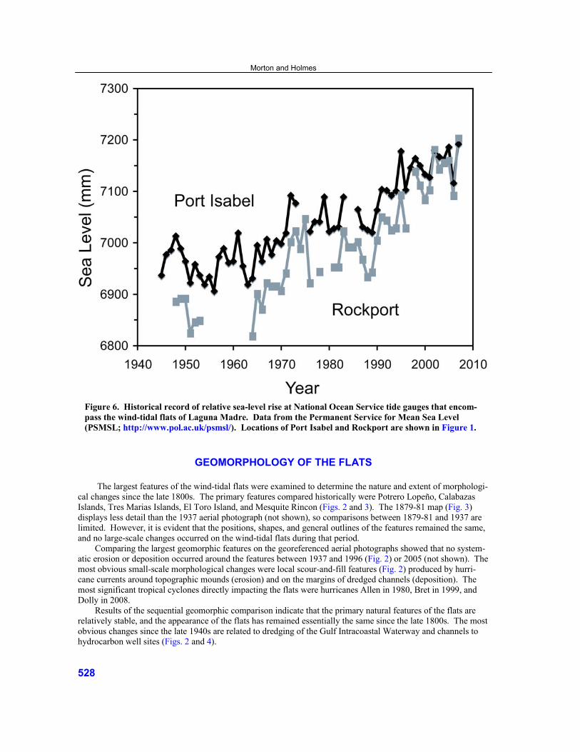
Figure 6. Historical record of relative sea-level rise at National Ocean Service tide gauges that encom-pass the wind-tidal flats of Laguna Madre. Data from the Permanent Service for Mean Sea Level (PSMSL; http://www.pol.ac.uk/psmsl/). Locations of Port Isabel and Rockport are shown in Figure 1.
GEOMORPHOLOGY OF THE FLATS The largest features of the wind-tidal flats were examined to determine the nature and extent of morphologi-
cal changes since the late 1800s. The primary features compared historically were Potrero Lopeño, Calabazas Islands, Tres Marias Islands, El Toro Island, and Mesquite Rincon (Figs. 2 and 3). The 1879-81 map (Fig. 3) displays less detail than the 1937 aerial photograph (not shown), so comparisons between 1879-81 and 1937 are limited. However, it is evident that the positions, shapes, and general outlines of the features remained the same, and no large-scale changes occurred on the wind-tidal flats during that period.
Comparing the largest geomorphic features on the georeferenced aerial photographs showed that no system-atic erosion or deposition occurred around the features between 1937 and 1996 (Fig. 2) or 2005 (not shown). The most obvious small-scale morphological changes were local scour-and-fill features (Fig. 2) produced by hurri-cane currents around topographic mounds (erosion) and on the margins of dredged channels (deposition). The most significant tropical cyclones directly impacting the flats were hurricanes Allen in 1980, Bret in 1999, and Dolly in 2008.
Results of the sequential geomorphic comparison indicate that the primary natural features of the flats are relatively stable, and the appearance of the flats has remained essentially the same since the late 1800s. The most obvious changes since the late 1940s are related to dredging of the Gulf Intracoastal Waterway and channels to hydrocarbon well sites (Figs. 2 and 4).
Morton and Holmes
528
Eolian Plain The eolian plain refers to the sand sheet (Forman et al., 2009) that covers the western margin of Laguna
Madre near the wind-tidal flats (Fig. 2). Price (1958) classified the eolian plain as a banner-dune complex be-cause the sharp angles sculpted by the wind create a pattern that is similar to a banner. The banners are oriented northwest-southeast, which is parallel to the predominant wind direction. Mesquite Rincon exhibits the same banner patterns, indicating that it is an erosional remnant of the eolian plain that once covered the area now occu-pied by the wind-tidal flats.
Potreros and Rincons The potreros and rincons of the Laguna Madre flats (Potrero Lopeño, El Toro Island, and the eastern margin
of Mesquite Rincon, Fig. 2) are compound geomorphic features that record a complex history of erosion and deposition by wind and water. Both landforms exhibit parallel construction of sand ridges that outline the former shapes and positions of the features. Both the potreros and rincons are attached to remnants of the eolian plain, so they formed after the eolian plain. Sand ridges of the potreros and rincons are oriented nearly perpendicular to the banner dunes, indicating that processes responsible for the formation of the potreros and rincons were differ-ent from those that formed the eolian plain. In contrast to the eolian plain, the northeast-southwest trending sand ridges of the potreros and rincons are oriented normal to the predominant wind direction, and they were shaped primarily by water when the flats were flooded.
Surficial Disturbance of the Flats
Despite their remote location, the wind-tidal flats have been the site of cattle ranching, seismic surveys, and
hydrocarbon exploration, production, and transmission. The northern part of the flats also was a bombing range during World War II. Because of these activities, the surfaces of the flats have been disturbed in some areas. The impacts of cattle trails, roads, pipelines, drilling sites, and spoil disposal are limited to narrow linear bands or relatively small areas, whereas remnant vehicle tracks could be present almost anywhere on the flats.
Surface disturbances potentially can alter the calculated rates of sedimentation and subsequent geological interpretation of the flats. Activities that compressed the sediments would decrease the estimated sedimentation rates. Deposition of dredged material has the greatest potential for invalidating rate results. Dredged material can alter the natural order of strata and create an artificial stratigraphy of disturbed sediments whereby older dredged sediments are deposited onto younger sediments at the surface. The most common disturbances on the flats have been excavation and backfilling of pipeline trenches and dredging of well locations, access channels, and the GIWW. Fortunately, the impacts of these activities are areally restricted, and the disturbed areas are eas-ily identified and were avoided when cores were collected.
Dredged Channels and their Hydrodynamic Effects Construction of the GIWW through the flats (Figs. 2 and 4) in 1948 altered the hydrodynamics of the flats by
reducing both their frequency and duration of flooding (Rusnak, 1960). Before the GIWW was dredged, strong or persistent winds from either the south or north would force water onto the flats where it would remain until it either gradually drained back into the permanently flooded part of Laguna Madre or it evaporated. However, since its construction, the GIWW provides an alternate route for the wind-driven water, and some water flows through the dredged channel rather than onto the flats (Breuer, 1957; Rusnak, 1960). In addition, water that is driven onto the flats probably remains a shorter time because it can drain into the GIWW rather than having to flow back across the flats.
Several shallow canals were dredged from the GIWW to the interior of the flats to provide access to hydro-carbon well sites (Figs. 2 and 4). These well canals also operate as conduits for water flowing onto or off of the flats. Their long-term influence on frequency and duration of flooding on the flats is uncertain, and these effects
Geological Processes and Sedimentation Rates of Wind-Tidal Flats, Laguna Madre, Texas
529

have likely changed as more canals have been dredged. Field evidence indicates that the canals act primarily as drains; water draining off the flats erodes branching channels at the heads of the canals and locally lowers eleva-tions of the flats around the canals.
SEDIMENT CHARACTERISTICS OF THE FLATS
Composition
The wind-tidal flats of Laguna Madre are composed primarily of siliciclastic sediments derived from the
land and transported to the flats by physical processes; however, some of the sediments are authigenic evaporites or precipitates. Results of the XRD analyses show that the most common minerals are quartz, feldspar, gypsum, halite, aragonite, calcite, dolomite, and smectite. These results agree with the mineral compositions that were previously reported by Fisk (1959) and Miller (1975). The clastic sediments, which include quartz, feldspar, and clay minerals (primarily smectite), are not unique to the wind-tidal-flat deposits; therefore, greater emphasis for geological interpretation is placed on the authigenic sediments, shells, and algal mats.
The flat deposits also contain crystals and thin layers of aragonite, calcite, dolomite, gypsum, and halite. The gypsum occurs in three forms: (1) layers or lenses of granular gypsum, (2) single-bladed crystals or small interlocking crystalline aggregates (gypsum rose), and (3) discrete nodules without any crystalline shape. The continuous thin beds and lenses of gypsum were deposited at or near the surface by evaporating seawater (Fisk, 1959; Masson, 1955; McBride et al., 1992). In contrast, the discrete nodules, crystalline aggregates, and single-bladed crystals were precipitated in the porous sand by highly saline groundwater that is periodically recharged by marine water flooding the flats (Fisk, 1959; Long and Gudramovics, 1983).
Chemical analyses show that organic matter is normally a minor component of the flat deposits; however, organic matter can be concentrated in algal mats that form continuous laminations and thin beds. The algal mats form at the surface and grow when the flats are flooded, but they become desiccated and may be destroyed when the flats are dry. In those areas that are frequently flooded, the algal mats form layers that are leathery and resist erosion. Algal mats form where the flats are frequently flooded, and they are diagnostic indicators of the inter-tidal zone of coastal deposition (Kinsman and Park, 1976; Schreiber, 1986)
Marine molluscs are commonly present in the wind-tidal-flat sediments, occurring either as disseminated whole valves or fragments, or as concentrated lenses. The most abundant molluscs are the marine species Anomalocardia auberiana and Mulinia lateralis, which also are abundant in Laguna Madre (Fisk, 1959; Rusnak, 1960; White et al., 1989).
Sedimentary Structures Most of the sediments from the wind-tidal flats are preserved as laminations that conform to the surface of
the flats. In some of the cores, laminations are disrupted by processes that were contemporaneous with deposi-tion. However, some of the disruptions occurred long after the sediments were deposited. Contemporaneous lamination disruption can be caused by desiccation of the sediments and algal mats, which forms mud cracks and causes the algal mats to curl up. Gas formation in the shallow sediments also can cause sediment disruption. Gas generated as the algal mats decompose migrates to the surface and causes the sediments and algal mats to heave or form blisters. Air trapped in the sandy sediments while they are flooded produces another common sedimen-tary structure known as “gas-bubble” or “sponge-cake” structure.
BRIEF GEOLOGICAL HISTORY The relations of eolian-plain sediments to underlying Pleistocene deposits and the relatively young age of
the dunes (Forman et al., 2009) indicate that the eolian plain formed during the Holocene. Wind erosion (deflation) of the area south of Potrero Lopeño (Fig. 2) removed most of the eolian landforms except Mesquite Rincon, a remnant landward of El Toro Island, scattered mounds such as Tres Marias Islands, and smaller un-
Morton and Holmes
530

named islands southwest of Mesquite Rincon. Sea level rose and began flooding the former upland area several thousand yr ago. This major geological event marked a change from dominantly wind erosion to dominantly marine deposition near the flats. The periodic flooding resulted in deposition of the interbedded sand, mud, algal mats, and evaporites that form the wind-tidal-flat deposits. The remnant islands were wave modified, and con-centric accretion ridges began to form around the islands. Sediments that caused accretion of the potreros and rincons were transported by the wind and later shaped by the water that periodically flooded the flats. Clay dunes that form the western margin of the flats also began to form about this time by accreting against remnant upland mounds. The potreros and rincons accreted seaward, whereas the flats aggraded vertically.
ISOTOPIC AGE DATING AND SEDIMENTATION RATES
Carbon-14 The wind-tidal-flat deposits contain algal material, shells, and carbonate sediments that can be used to obtain
radiocarbon ages of the sediments and for estimating rates of sedimentation. The primary sources of error that could invalidate the 14C dates are sediment reworking and geochemical contamination, including the well-known marine-reservoir effect (Hughen et al., 2004). Fisk (1959) reported anomalously old and stratigraphically incon-sistent 14C dates for relatively shallow sediments beneath the flats. Fisk attributed the erroneous dates to re-worked shell material. Contamination probably explains why dates derived from shells and carbonate material are slightly older than those derived from algal material taken from similar horizons beneath the wind-tidal flats (comments by J. A. Miller in Valastro et al., 1972). Friedman et al. (1973) also found an older age bias in shells compared to algal material.
All the 14C dates reported for this study were obtained from discrete algal mats in growth position in cores 5, 7, 8, 10, 12, and 13 (Fig. 4; Table 1). The algal mats were processed to remove all carbonate material. There-fore, the algal mats should be free of contamination by recycled older carbon and should provide accurate dates for the wind-tidal flat sediments.
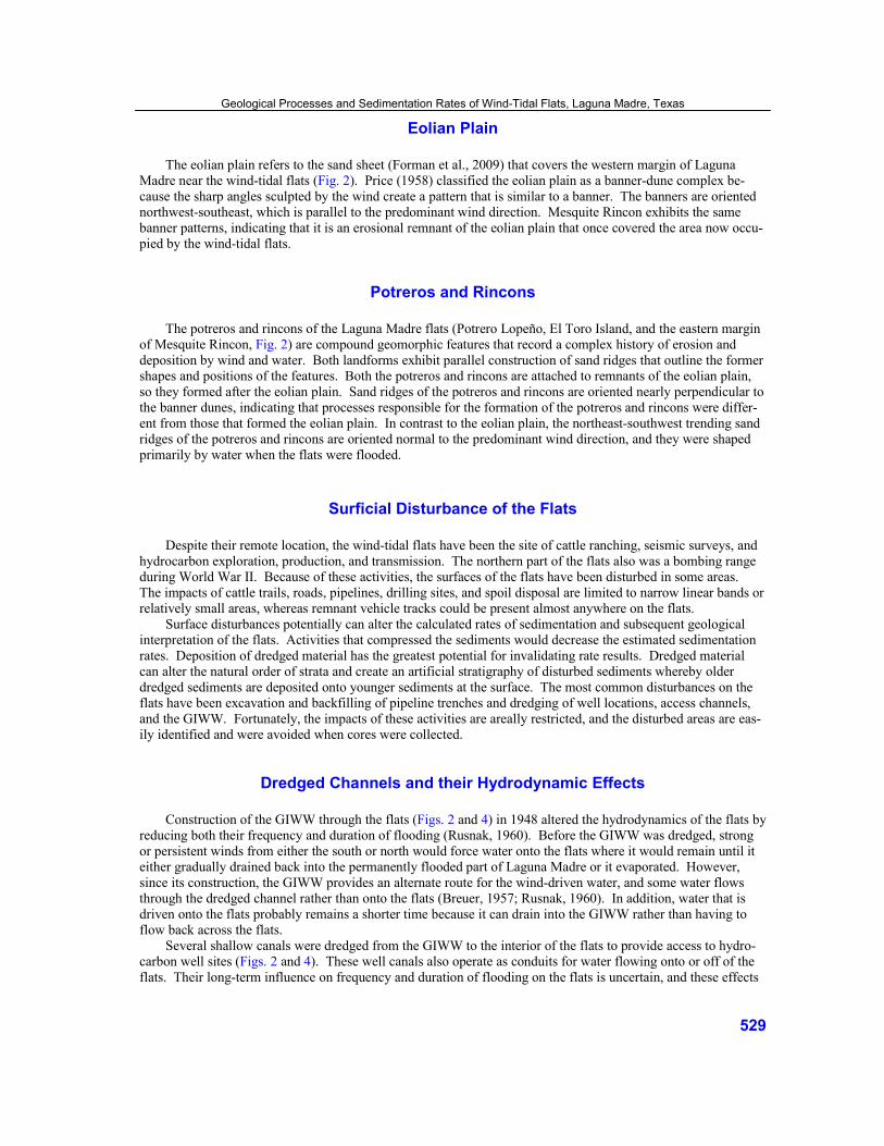
Average geological rates of sedimentation for the wind-tidal flats were estimated using the radiocarbon ages and depths of algal samples (Table 1). For those cores with more than one dated sample, two different rates of sedimentation can be calculated using the same data. Dividing sample depth by sample age gives the simplest but least accurate estimate. This end-point calculation yields an average rate of sedimentation for the total thick-ness of sediments. A more accurate method of calculating sedimentation rates recognizes that different rates of sedimentation can occur at different times. For the second method, the difference in depths and difference in sediment ages at the top and bottom of an interval are used to calculate an interval rate of sedimentation. The interval method does not average the rate of sedimentation for the entire depth of the sample but restricts the av-eraging to only the interval of interest. Sedimentation rates calculated using the end-point method range from 0.13 mm/yr to 0.71 mm/yr and average 0.57 mm/yr. Sedimentation rates calculated using the interval method are higher, ranging from 0.50 mm/yr to 0.96 mm/yr and averaging 0.77 mm/yr. Although composite plots of radio-carbon ages with depth (Fig. 7) or sedimentation rates (Fig. 8) do not show pronounced changes in sedimentation rate with time, values in individual cores (5B, 7A, 12B, and 13B) show consistent decreases in end-point sedi-mentation rate for younger sediments (Table 1).
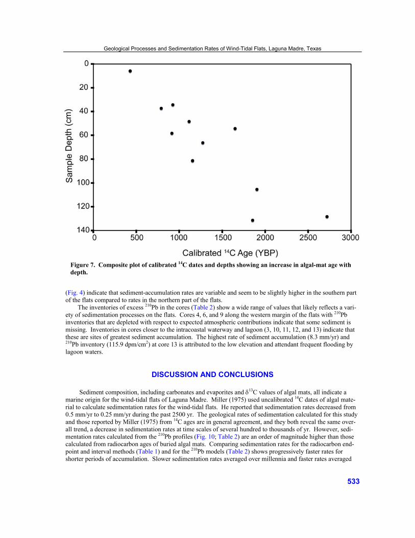
Delta Carbon-13 The δ13C values for the wind-tidal-flat algal mats in Laguna Madre fall within a relatively narrow range be-
tween -12.6% and -15.2% (Table 1). The δ13C values greater than -15.2% indicate that the algal mats are entirely marine in origin, and there is no apparent terrestrial influx of organic carbon that would make them isotopically lighter. Time- and depth-dependent geochemical changes in the depositional environment are indicated by the shift toward more positive δ13C values for older mats (Fig. 9). The enrichment of δ13C with time (depth) is partly related to the oxidation-reduction state, with sediments in a reduced state having slightly heavier isotopic values (Table 1).
Behrens and Frishman (1971) reported depth-related isotopic variations in algal mats from Baffin Bay, Texas, an estuary located about 30 km north of the study area (Fig. 1). They determined that organic carbon
Geological Processes and Sedimentation Rates of Wind-Tidal Flats, Laguna Madre, Texas
531

Core Number
Sample Depth (cm)
Eh State δ13C (‰)
Conventional 14C Age
± 1 sigma
Calibrated Radiocarbon Ages (YBP) @ 1 sigma
(95% probability) Intercept Lower Upper
End-Point Rate
(mm/yr)
Interval Rate
(mm/yr)
LM-5B -5.5 Oxidized -15.2 770 ± 80 425 379 464 0.13 0.87
LM-5B -37.0 Transition -14.8 1240 ± 70 785 721 846 0.47
LM-7A -34.0 Oxidized -15.2 1420 ± 60 920 910 1038 0.37 0.91 0.62 LM-7A -66.0 Reduced -16.1 1720 ± 60 1270 1228 1322 0.52
LM-7A -105.0 Reduced -13.8 2300 ± 70 1900 1853 1978 0.55
LM-8B -131.0 Reduced -12.9 2250 ± 60 1850 1812 1896 0.71
LM-10A -54.0 Reduced -13.5 2070 ± 10 1645 1596 1691 0.33
LM-12B -48.0 Reduced -13.7 1560 ± 80 1110 1071 1162 0.43 0.50
LM-12B -128.0 Reduced -12.6 2930 ± 70 2715 2692 2740 0.47
LM-13B -58.0 Reduced -14.3 1370 ± 70 910 887 953 0.64 0.96
LM-13B -81.0 Reduced -14.3 1590 ± 70 1150 1112 1210 0.70
Table 1. Average sedimentation rates for selected cores based on the intercept calibrated radiocarbon ages and depths of algal samples. Eh state was determined visually by sediment color. Calibrated ages were calculated by the program OxCal 5.0.1 using the Marine04 correction (Hughen et al., 2004).
within the mats was isotopically heavier than organic carbon in the bay sediments. They attributed the differ-ences to fractionation associated with anaerobic bacterial decomposition of the algal mats. They also demon-strated a slight shift toward heavier (more positive) δ13C values with depth. In another study of organic carbon in sediments from Baffin Bay, Anderson et al. (1992) reported cycles of δ13C enrichment and depletion and an over-all slight shift toward more positive values at depth. They interpreted the cycles and overall trend as the result of mixing two primary sources of organic carbon: seagrass, which is isotopically heavy (-10%), and phytoplankton, which is isotopically light (-20%). Their interpretation also implies that seagrass sources were predominant ear-lier in the history of Baffin Bay, whereas phytoplankton sources were predominant as the bay continued to fill but under conditions that did not favor establishment of seagrass meadows.
Lead-210 Excess 210Pb decreases downcore in the upper 15 cm of most of the wind-tidal-flat cores (Fig. 10). In some
cores, however, excess 210Pb is highly variable below 15 cm. This trend may be caused either by sediment mix-ing or geochemical reactions. Loading, burrowing, or desiccation can cause in-situ mixing of the wind-tidal-flat sediments. However, trench exposures show that natural disruption of sediment laminations is minor. In addi-tion, comparison of 210Pb vertical trends with core photographs and compaction measurements indicates that there is no clear correlation among sediment disruption, core compaction, and anomalous 210Pb trends. A possible ex-planation for anomalously high excess 210Pb at depth involves atmospheric lead getting into the groundwater, the groundwater circulating through the porous sediments, and lead in the groundwater exchanging with calcium in the calcite and gypsum minerals in the sediments.
Excess 210Pb profiles indicate that historical rates of sedimentation can be calculated for cores 1, 3, 6, 10, 11, 12, and 13. Excess 210Pb trends for the other cores are considered to be too erratic for accurate determinations of sedimentation rates. The magnitudes and distribution of sedimentation rates calculated from the 210Pb profiles
Morton and Holmes
532
(Fig. 4) indicate that sediment-accumulation rates are variable and seem to be slightly higher in the southern part of the flats compared to rates in the northern part of the flats.
The inventories of excess 210Pb in the cores (Table 2) show a wide range of values that likely reflects a vari-ety of sedimentation processes on the flats. Cores 4, 6, and 9 along the western margin of the flats with 210Pb inventories that are depleted with respect to expected atmospheric contributions indicate that some sediment is missing. Inventories in cores closer to the intracoastal waterway and lagoon (3, 10, 11, 12, and 13) indicate that these are sites of greatest sediment accumulation. The highest rate of sediment accumulation (8.3 mm/yr) and 210Pb inventory (115.9 dpm/cm2) at core 13 is attributed to the low elevation and attendant frequent flooding by lagoon waters.
DISCUSSION AND CONCLUSIONS Sediment composition, including carbonates and evaporites and δ13C values of algal mats, all indicate a
marine origin for the wind-tidal flats of Laguna Madre. Miller (1975) used uncalibrated 14C dates of algal mate-rial to calculate sedimentation rates for the wind-tidal flats. He reported that sedimentation rates decreased from 0.5 mm/yr to 0.25 mm/yr during the past 2500 yr. The geological rates of sedimentation calculated for this study and those reported by Miller (1975) from 14C ages are in general agreement, and they both reveal the same over-all trend, a decrease in sedimentation rates at time scales of several hundred to thousands of yr. However, sedi-mentation rates calculated from the 210Pb profiles (Fig. 10; Table 2) are an order of magnitude higher than those calculated from radiocarbon ages of buried algal mats. Comparing sedimentation rates for the radiocarbon end-point and interval methods (Table 1) and for the 210Pb models (Table 2) shows progressively faster rates for shorter periods of accumulation. Slower sedimentation rates averaged over millennia and faster rates averaged
Figure 7. Composite plot of calibrated 14C dates and depths showing an increase in algal-mat age with depth.
Geological Processes and Sedimentation Rates of Wind-Tidal Flats, Laguna Madre, Texas
533

over centuries are the result of sediment erosion or depositional hiatuses and the cumulative missing section that increases over longer periods of observation (Sadler, 1999). Consequently, the sedimentation rates derived for historical and geological time scales cannot be compared directly.
The long-term balance between sedimentation and sea-level rise and the impact of these processes on the future status of the wind-tidal flats of Laguna Madre can be tested with the available data. The relative rise in sea level recorded at Rockport and Port Isabel is about 3 to 4 mm/yr (Fig. 6), whereas the average aggradation rate of the flats calculated from the isotopic data ranges from about 0.6 mm/yr to 2.2 mm/yr (Fig. 4; Tables 1 and 2). Even the historical rates of sediment accumulation (2.2 mm/yr) are substantially lower than the global rates of sea-level rise predicted by the Intergovernmental Panel on Climate Change (2007) as a result of global warming. Because aggradation of the flats likely will not keep pace with the rise in sea level, the flats will slowly be sub-merged and will eventually become permanently inundated.
ACKNOWLEDGMENTS The fieldwork, laboratory analyses, and preliminary report writing were conducted while the first author
was at the University of Texas at Austin, Bureau of Economic Geology. Marcie Marot (U.S. Geological Survey) performed the 210Pb analyses, and Beta Analytic Inc., Miami, Florida, conducted the carbon isotope analyses. CWH is retired from the U.S. Geological Survey and is not associated with Environchron LLC. Technical re-views by Shawn Dadisman (U.S. Geological Survey) and Seay Nance (University of Texas at Austin, Bureau of Economic Geology) improved clarity and content of the manuscript.
Figure 8. Composite plot of end-point sedimentation rates and calibrated 14C ages of algal mat samples (Table 1) from the wind-tidal flats of Laguna Madre. Except for one outlier, the values show no clear temporal trend in sedimentation rates.
Morton and Holmes
534
Figure 9. Plot of δ13C values and intercept calibrated radiocarbon ages for the wind-tidal flat algal mats showing more negative δ13C values in younger sediments.
REFERENCES CITED
Anderson, B., R. S. Scalan, E. W. Behrens, and P. L. Parker, 1992, Stable carbon isotope variations in sediment from Baffin Bay, Texas, U.S.A.: Evidence for cyclic changes in organic matter source: Chemical Geology, v. 101, p. 223-233.
Appleby, P. G., and F. Oldfield, 1992, Application of lead 210 to sedimentation studies, in M. Ivanovich and
R. S. Harmon, eds., Uranium-series disequilibrium: Applications to earth, marine and environmental sciences: Clarendon Press, Oxford, U.K., p. 731-778.
Baskaran, M., C. H. Colman, and P. H. Santshi, 1993, Atmospheric depositional fluxes of 7Be and 210Pb at Galveston
and College Station, Texas: Journal of Geophysical Research, v. 98, p. 20555-20571. Behrens, E. W., and S. A. Frishman, 1971, Stable carbon isotopes in blue-green algal mats: Journal of Geology, v. 79,
p. 94-100. Binford, M. W., 1990, Calculation and uncertainty analysis of 210Pb dates for PIRLA project lake sediment cores: Jour-
nal of Paleolimnology, v. 3, p. 253-267.
Geological Processes and Sedimentation Rates of Wind-Tidal Flats, Laguna Madre, Texas
535

Bomar, G. W., 1995, Texas weather: University of Texas Press, Austin, 265 p. Breuer, J. P., 1957, An ecological survey of Baffin and Alazan bays, Texas: Publications of the Institute of Marine
Science, University of Texas at Austin, v. 4, p. 134-141. Douglas, B. C., 2001, Sea level change in the era of the recording tide gauge, in B. C. Douglas, M. S. Kearney, and
S. P. Leatherman, eds., Sea level rise: Academic Press, San Diego, California, 228 p. Fisk, H. N., 1959, Padre Island and the Laguna Madre flats, coastal south Texas: Proceedings of the Second Coastal
Geography Conference, Louisiana State University, Baton Rouge, p. 103-151. Flynn, W. W., 1968, The determination of 210Pb in environmental materials: Analytica Chimica Acta, v. 43, p. 121-131. Forman, S. L., L. Nordt, J. Gomez, and J. Pierson, 2009, Late Holocene dune migration on the south Texas sand sheet:
Geomorphology, doi: 10.1016/j.geomorph.2009.01.001. Friedman, G. M., A. J. Amiel, M. Braun, and D. S. Miller, 1973, Generation of carbonate particles and laminites in
algal mats—Examples from sea-marginal hypersaline pool, Gulf of Aqaba, Red Sea: American Association of Petroleum Geologists Bulletin, v. 57, p. 541-557.
Gill, S. K., J. R. Hubbard, and G. Dingle, 1995, Tidal characteristics and datums of Laguna Madre, Texas: National
Oceanic and Atmospheric Administration Technical Memorandum, NOS OES 008, 57 p.
Figure 10. Depth profiles of percent organics (LOI), percent water, and 210Pb concentration in core 10 showing systematic decrease of 210Pb in the upper 15 cm of sediment.
Morton and Holmes
536

Core X0 210Pb activity (dpm/g)
Sedimentation rate 210Pb in-ventory
(dpm/cm2) CRS
(mm/y) CIC
(mm/y) CRS
(g/cm2/y)
LM 3A 5.8 ± 0.02 0.7 ± 0.3 0.8 ± 0.2 0.97 ± 0.49 28.00
LM 4C 0.9 ± 0.02 1.5 ± 0.6 2.7 ± 0.2 0.35 ± 0.28 11.46
LM 6B 1.3 ± 0.05 3.3 ± 0.5 2.8 ± 0.3 0.48 ± 0.37 11.91
LM 9A 0.9 ± 0.05 1.4 ± 0.4 2.2 ± 0.2 0.25 ± 0.16 11.38
LM 10A 2.1 ± 0.2 1.1 ± 0.2 1.6 ± 0.1 0.18 ± 0.09 51.70
LM 11A 1.9 ± 0.3 5.0 ± 1.3 2.5 ± 0.2 1.64 ± 0.13 31.23
LM 12B 1.62 ± 0.5 2.2 ± 0.4 2.8 ± 0.2 0.40 ± 0.02 23.74
LM 13B 3.31 ± 0.3 8.3 ± 1.4 8.3 ± 0.5 1.21 ± 0.21 115.90
Table 2. Average historical sedimentation rates of the wind-tidal flats derived from 210Pb profiles. CRS = Constant Rate of Supply model, and CIC = Constant Initial Concentration model.
Hansen, E. A., 1960, Studies of a channel through Padre Island, Texas: American Society of Civil Engineers, Journal
of Waterways and Harbors Division, v. 86, p. 63-82. Holmes, C. W., J. Robbins, R. Halley, M. Bothner, M. T. Brink, and M. Marot, 2001, Sediment dynamics of Florida
Bay mud banks on a decadal time scale, in B. R. Wardlaw, ed., Paleoecological studies of south Florida: Bulletins of American Paleontology 361, p. 31-40.
Hughen, K. A., M. G. L. Baillie, E. Bard, A. Bayliss, J. W. Beck, C. Bertrand, P. G. Blackwell, C. E. Buck, G. Burr,
K. B. Cutler, P. E. Damon, R. L. Edwards, R. G. Fairbanks, M. Friedrich, T. P. Guilderson, B. Kromer, F. G. McCormac, S. Manning, C. Bronk Ramsey, P. J. Reimer, R. W. Reimer, S. Remmele, J. R. Southon, M. Stuiver, S. Talamo, F. W. Taylor, J. van der Plicht, and C. E. Weyhenmeyer, 2004, Marine04 marine radiocar-bon age calibration, 0-26 Cal Kyr BP: Radiocarbon, v. 46, p. 1059-1086.
Intergovernmental Panel on Climate Change, 2007, Climate Change 2007: Impacts, adaptation and vulnerability, in
M. L. Parry, O. F. Canziani, J. P. Palutikof, P. J. van der Linden, and C. E. Hanson, eds., Contribution of Working Group II to the Fourth Assessment Report of the Intergovernmental Panel on Climate Change: Cambridge Univer-sity Press, Cambridge, U.K., 976 p.
Kinsman, D. J. J., 1969, Modes of formation, sedimentary associations and diagnostic features of shallow-water and
supratidal evaporites: American Association of Petroleum Geologists Bulletin, v. 53, p. 830-840. Kinsman, D. J. J., and R. L. Park, 1976, Algal belt and coastal sabkha evolution, Trucial coast, Persian Gulf, in
M. R. Walter, ed., Stromatolites: Developments in Sedimentology 20, Elsevier, Amsterdam, The Netherlands, p. 421-433.
Lanesky, D. E., B. W. Logan, R. G. Brown, and A. C. Hine, 1979, A new approach to portable vibracoring underwater
and on land: Journal of Sedimentary Petrology, v. 49, p. 654-657. Levy, Y., 1977, Description and mode of formation of the supratidal evaporite facies in the northern Sinai coastal plain:
Journal of Sedimentary Petrology, v. 47, p. 463-474. Long, D. T., and R. Gudramovics, 1983, Major-element geochemistry of brine from the wind-tidal flat area, Laguna
Madre, Texas: Journal of Sedimentary Petrology, v. 53, p. 797-810.
Geological Processes and Sedimentation Rates of Wind-Tidal Flats, Laguna Madre, Texas
537

Masson, P. H., 1955, An occurrence of gypsum in southwest Texas: Journal of Sedimentary Petrology, v. 25, p. 72-77. McBride, E. F., H. Honda, A. A. Abdel-Wahab, S. Dworkin, and T. A. McGilvery, 1992, Fabric and origin of gypsum
sand crystals, Laguna Madre, Texas: Gulf Coast Association of Geological Societies Transactions, v. 42, p. 543-552.
Miller, J. A., 1975, Facies characteristics of Laguna Madre wind-tidal flats, in R. N. Ginsburg, ed., Tidal deposits:
Springer-Verlag, New York, p. 67-73. Molnar, T. M., and D. J. Smith, 1993, Gamma-ray logging of vibracore holes: Journal of Sedimentary Petrology, v. 63,
p. 758-760. Morton, R. A., and W. A. White, 1997, Characteristics of and corrections for core shortening in unconsolidated sedi-
ments: Journal of Coastal Research, v. 13, p. 761-769. Paine, J. G., 1993, Subsidence of the Texas coast: Inferences from historical and late Pleistocene sea levels: Tectono-
physics, v. 222, p. 445-458. Patterson, R. J., and D. J. J. Kinsman, 1981, Hydrologic framework of a sabkha along the Arabian Gulf: American
Association of Petroleum Geologists Bulletin, v. 65, p. 1457-1475. Price, W. A., 1958, Sedimentology and Quaternary geomorphology of South Texas: Gulf Coast Association of Geo-
logical Societies Transactions, v. 8, p. 41-75. Press, W. H., S. A. Teukolsky, W. T. Vetterling, and B. P. Flannery, 2007, Numerical recipes: The art of scientific
computing: Cambridge University Press, New York, 1265 p. Robbins, J. A., 1978, Geochemical and geophysical applications of radioactive lead, in J. O. Nriagu, ed., Biogeochemis-
try of lead in the environment, v. 1A: Elsevier Science, New York, p. 285-303. Rusnak, G. A., 1960, Sediments of Laguna Madre, in F. P. Shepard, F. B. Phleger, and T. J. van Andel, eds., Recent
sediments, northwest Gulf of Mexico: American Association of Petroleum Geologists, Tulsa, Oklahoma, p. 153-196.
Sadler, P. M., 1999, The influence of hiatuses on sediment accumulation rates: GeoResearch Forum, v. 5, p. 15-40. Schreiber, B. C., 1986, Arid shorelines and evaporites, in H. G. Reading, ed., Sedimentary environments: Blackwell,
Oxford, U.K., p. 189-228. Simpson, R. H., and M. B. Lawrence, 1971, Atlantic hurricane frequencies along the U.S. coastline: National Oceanic
and Atmospheric Administration Technical Memorandum NWS SR-581, 15 p. Swanson, R. L., and C. L. Thurlow, 1973, Recent subsidence rates along the Texas and Louisiana coasts as determined
from tide measurements: Journal of Geophysical Research, v. 78, p. 2665-2671. Valastro, S., Jr., E. M. Davis, and A. G. Varela, 1972, University of Texas at Austin radiocarbon dates IX: Radiocar-
bon, v. 14, p. 461-485. White, W. A., T. R. Calnan, R. A. Morton, R. S. Kimble, and T. G. Littleton, 1989, State submerged lands of Texas,
Kingsville area—Sediments, geochemistry, benthic macroinvertebrates, and associated wetlands: Texas Bureau of Economic Geology, Austin, 137 p.
Zervas, C., 2001, Sea level variations of the United States 1854-1999: National Oceanic and Atmospheric Administra-
tion Technical Report NOS CO-OPS 36, 66 p.
Morton and Holmes
538