geology and oil and gas prospects op northeastern colorado ... · geology and oil and gas prospects...
TRANSCRIPT

GEOLOGY AND OIL AND GAS PROSPECTS OP NORTHEASTERN COLORADO
By KIRTLEY F. MATHER, JAMES GILLULY, and RALPH G. LUSK
INTRODUCTION
LOCATION AND EXTENT OF THE AREA
The region described in this report comprises that portion of Colorado which lies east of the Front Range of the Rocky Mountains and north of the latitude of Denver. It includes the eastern part of Larimer County, all of Weld, Morgan, Logan, Sedgwick, and Phillips Counties, and parts of Adams, Arapahoe, Washington, and Yuma Counties. It measures about 150 miles from east to west and about 80 miles from north to south.
A narrow strip of this region along the north boundary of Colo rado and much of its eastern half are covered by nearly continuous beds of comparatively recent gravel and sand which effectively hide the bedrock formations over large areas. The field investigations were therefore concentrated in and near Larimer, Weld, Morgan, and Logan Counties, and the area shown on the accompanying geo logic map (pi. 14) does not extend to the east boundary of the State. The relations of the mapped area to its surroundings are shown in Figure 4.
OIL AND GAS DEVELOPMENT IN NORTHEASTERN COLORADO
The occurrence of oil in commercial quantities in the small oil field near Boulder, Colo., and the presence of several developed oil fields in Wyoming have for many years called attention to the intervening territory as a possible source of petroleum. Desultory drilling at widely scattered localities and at various dates failed, however, for a long time, to prove that either oil or gas was present, and it was not until 1923 that the first successful well was completed.
Prior to 1915 the anticlinal folds north of Fort Collins had been recognized by several geologists, among whom may be noted Junius Henderson, of the University of Colorado, R. D. George, State geologist of Colorado, R. C. Hills, and C. A. Fisher. In that year
65

66 COFTEIBUTIONS TO ECONOMIC GEOLOGY, 1921, PAET IE
a well was drilled by the Poudre Oil & Gas Co. in the SW. % NE. % sec. 31, T. 9 N., R. 68 W.,1 " at about the only point on the anticline where the dip in both directions is plainly visible." The well was drilled to a depth of nearly 4,000 feet and was abandoned after obtaining no more than showings of oil and gas.
In 1917 and 1918 geologists of the Roxana Petroleum Corporation spent several months in detailed geologic examination of the region north of Fort Collins. Pits were dug at critical points to reveal the geologic structure, and natural and artificial exposures of the underlying rocks were carefully studied. The result was a struc-
109°_______108_______107 105° 104°_______103 102°
25 SO 75 100 MILES
FIGURE 4. Index map of Colorado. Shading indicates area covered in this report
ture map which has been little modified by subsequent work. It was then noted that the Poudre well was in a saddle between two high portions of the Fort Collins-Wellington anticline and was not within any structural trap such as has proved elsewhere to be a prime factor in determining the location of an oil pool.
The Roxana Corporation accordingly made an arrangement with the Keoughan-Hurst Drilling Co. for a test well on the summit of the more northerly of the two domes on this long, narrow anticline, to be drilled to a shallow sand at about the same stratigraphic hori zon as the sands from which oil is obtained in the field near
1 Ball, M. W., Gas near Fort Collins, Colo.: Am. Assoc. Petroleum Geologists Bull., "o pp. 79-87, 1924.

GEOLOGY OF NORTHEASTERN COLORADO 67
Boulder. This well was drilled to a depth of 1,312 feet and aban doned after finding only a little oil in the sand encountered at that depth. The local geologists of the Roxana Corporation recommended drilling to the deeper sands, such as those from which good produc tion was being obtained in Wyoming, but the company abandoned its leases, without further drilling, in the fall of 1920.
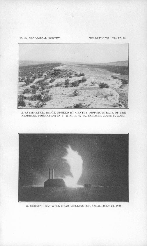
A little later the structure was brought to the attention of the Union Oil Co. of California, and after obtaining leases covering all the favorable territory 'this company located its test well in the SW. % NW. % sec. 31, T. 10 N., R. 68 W., 300 feet southwest of the Roxana Keoughan-Hurst hole. This well was completed on Novem ber 11, 1923, at a depth of 4,283 feet. The gas pressure was so strong that the well was not brought under control until 49 davs later, when it gaged 82,000,000 cubic feet of gas a day. From the start the gas was very wet, and the amount of oil steadily increased until a month later the well was reported to be capable of producing about 400 barrels a day., The same company commenced its Mitchell No. 1 well on February 19, 1924, in the NE. % sec. 6, T. 9 N., R. 68 W., about a mile south of the discovery well. Like its predecessor, it came in as a tre mendous gasser, out of control, on July 19, 1924, at a depth of 4,216 feet. Before the control valve could be properly closed, on July 23, the gas was ignited, either by frictional electricity or by a spark struck from one of the pebbles blown upward with the gas. The huge flaring torch, with its roaring flame leaping a hundred feet or more into the air (pi. 15, Z?.), resisted all efforts to extinguish it until on August 14 it was successfully dynamited. When finally brought under control, the gas flow was gaged as 63,000,000 cubic feet a day. . «
In the meantime the Union Oil Co.'s first test on the southern part of the Fort Collins-Wellington anticline had been begun in the NW. % sec. 30, T. 8 N., R. 68 W. It was completed on August 7, 1924, at a depth of 4,475 feet. The drilling of the last few feet of this well was done through a control gate, with every precaution against such losses as had occurred in the two wells near Wellington. In consequence, the well was successfully controlled from the start. It proved to be an oil well capable of producing several hundred barrels a day.
While the search for oil in the vicinity of Fort Collins was thus passing through .the several stages of initial failure and discourage ment, careful geologic examination leading to encouraging recom mendations, and final success, a number of tests were made in other parts of northeastern Colorado. One hole near Round Butte, in sec. 12, T. 11 N., R. 69 W., was drilled by the Cactus Petroleum Co. in 1919. It was located upon an anticlinal fold and was deep

68 CONTRIBUTIONS TO ECONOMIC GEOLOGY, 192*7, PART II
enough to test the sands from which production was later obtained on the Fort Collins-Wellington anticline. Nevertheless it failed to yield oil or gas.
Most of the other wells drilled at that time were so located as not to be critical tests of the oil possibilities. Among these may be mentioned the Padroni well, in sec. 34, T. 10 N., R. 52 W., near Sterling, drilled in 1917 by the Sterling Oil Co. and abandoned at 4,350 feet after getting only showings of oil and gas; the well in sec. 2, T. 2 N., R. 53 W., near Akron, drilled to a depth of 4,399 feet by the Akron Oil & Gas Co. with similar disappointing results; four wells in ,secs. 14, 17, and 20, T. 2 N., R. 43 W., southeast of Wray, drilled by the Midfields Oil Co.; and one in sec. 28 of the same township, drilled by the Consolidated Oil Co. At least two of the Midfields wells encountered gas, but neither these nor the Con tinental's wells have produced oil in commercial amounts.
PURPOSE OF THIS REPORT
The brief historical sketch of the search for oil in northeastern Colorado given above shows clearly that there was need for a careful investigation of the oil and gas prospects of this entire region. Such an investigation was undertaken by the United States Geo logical Survey in the attempt to solve several geologic problems, among the more important of which may be noted the following: What is the geologic horizon from which the production of oil and gas on the Fort Collins-Wellington anticline had been obtained? Is this the so-called " Niobenton sand," the Wall Creek sand of Wyoming, or the Muddy sand? Are there additional reservoir sands within a few hundred feet below that from which production had been obtained? Are there other anticlinal folds from which production may be expected either near the Fort Collins-Wellington anticline or at other places in northeastern Colorado ? If such folds exist at localities far distant to the east, is the producing sand near enough to the surface at those localities to justify drilling operations?
It was in an attempt to answer such questions as these that the field investigation was undertaken and this report prepared. It is not the purpose of the report to point out the specific localities at which test wells should be sunk. Rather it is to consider the more general problems of the entire region and thus to indicate the locali ties in which detailed studies, such as are prerequisite to the selection of drilling sites, are justified and desirable.
EARLIER INVESTIGATIONS
Northeastern Colorado was visited more than half a century ago by geologists connected with various exploratory expeditions and

GEOLOGY OF NORTHEASTERN COLORADO 69
Government surveys. The work of such pioneers as Hayden,2 Stevenson,3 and Meek 4 was of a reconnaissance nature but served admirably to depict the broader geologic features of this region. Although interested in the general problem of the mineral resources of the regions which they surveyed, neither of these men directed his geologic investigations specifically toward the study of oil and gas. Contrary to the rather widespread opinion held in Colorado at the present time, Hayden's map is not an " oil map." No map of Colorado prepared by him was intended to indicate in any way the occurrence of oil and gas beneath the surface of the State.
After this pioneer work parts of the area here described were studied in considerable detail by geologists of the United States Geological Survey and of the Colorado Geological Survey. Special reference should be made to the survey of the Denver Basin by Cross, Emmons, and Eldridge,5 the reports on the geology of the central Great Plains by Darton,6 and the papers on Cretaceous stratigraphy by Stanton 7 and Henderson.8
Since the great interest in the oil and gas possibilities of this region has arisen in more recent years a number of geologists have published contributions which have a direct bearing upon the petro leum resources. In 1921 Lee examined in considerable detail the outcrops of oil-bearing formations along the eastern front of the Rocky Mountains in Colorado and Wyoming.9 A little later, under the direction of R. D. George, State geologist, a reconnaissance exam ination of Weld County was made for the Greeley Chamber of Com merce by Lavington.10 The same year a similar study of Logan
3 Hayden, F. V., Preliminary field report of the United States Geological Survey of Colo rado and New Mexico, Washington, 1869; reprinted in U. S. Geol. and Geog. Survey First, Second, and Third Ann. Repts., for 1867, 1868, 1869, Washington, 1873.
3 Stevenson, J. J., Report on the geology of a portion of Colorado examined in 1873: U. S. Geog. and Geol. Expl. W. 100th Her. Rept., vol. 3, pt. 4, 1875.
*Meek, F. B., and Hayden, F. V., Descriptions of new Lower Silurian (Primordial), Jurassic, Cretaceous, and Tertiary fossils, collected in Nebraska Territory * * * with some remarks on the rocks from which they were obtained: Acad. Nat. Sci. Philadelphia Proc., 1861, pp. 415-447.
B Emmons, S. F., Cross, Whitman, and Eldridge, G. H., Geology of the Denver Basin: U. S. Geol. Survey Mon. 27, 1896.
0 Darton, N. H., Preliminary report on the geology and underground water resources of the central Great Plains: U. S. Geol. Survey Prof. Paper 32, 1905; Geology and under ground waters of the Arkansas Valley in eastern Colorado: U. S. Geol. Survey Prof. Paper 52, 1906.
7 Stanton, T. W. f and Knowlton, F. H., Stratigraphy and paleontology of the Laramie and related formations in Wyoming: Geol. Soc. America Bull., vol. 8, pp. 127-156, 1897; abstract, Jour. Geology, vol. 5, pp. 102-103, 1897. Stanton, T. W., The Morrison forma tion and its relations with the Comanche series and the Dakota formations: Jour. Geology, vol. 13, pp. 657-669, 1905; abstract, Science, new ser., vol. 22, pp. 755-756, 1905.
8 Henderson, Junius, The Cretaceous formations of northeastern Colorado: Colorado Geol. Survey Bull. 19, 1920.
0 Lee, W. T., Continuity of some oil-bearing sands of Colorado and Wyoming: U. S. Geol. Survey Bull. 751, pp. 1-22, 1923.
10 Lavington, C. R., Reconnaissance of the Cretaceous area of Weld County, ColO., Gree ley Chamber of Commerce, Greeley, ColO., 1924.

70 CONTRIBUTIONS TO ECONOMIC GEOLOGY, 1927. PAET It
County was made for the Sterling Chamber of Commerce by Mohr and Koenig.11 Ball 12 gave a brief record of the discovery of gas near Fort Collins.
In 1913 the Colorado Geological Survey published a geologic map of the State, based largely on surveys that had been made by Federal and State geologists. The mapping of the greater part of the valley of South Platte Biver was generalized and was largely the result of a very hasty reconnaissance survey by Henderson. Since that time Henderson has been able to make more careful examinations of parts of the region, and in consequence of the need for revision which thus became manifest the Colorado Geological Survey placed a num ber of parties in the field during the summer of 1924. In the fall of that year it published a preliminary copy of Toepelman's revision of the part of the State map covering most of the area now under consideration.13
FIELD WORK
The investigations on which the present report is based were made during the summer of 1924. The work was begun by J. D. Sears, with the assistance of James Gilluly and R. G. Lusk, about the middle of May. A month later Mr. Sears returned to Washington, and thereafter the field studies were under the direction of K. F. Mather and during his temporary absence from the field were carried for ward by Mr. Gilluly.
The structure and stratigraphy in the Fort Collins and Wellington districts were first examined. Traverses were run with alidade and plane table to determine the thickness of the Cretaceous beds exposed near the mountains. Field work was then extended eastward to the State boundary. Special attention was paid to the area in which Cretaceous rocks were exposed at the surface by the erosion of the veneer of Tertiary gravel, sand, and clay which formerly covered all of the region under investigation.
Later in the season John B. Reeside, jr., spent about a week with the party investigating the changes in stratigraphy between the exposures of south-central Wyoming and north-central Colorado. Toward the end of the summer a similar service was rendered by T. W. Stanton.
ACKNOWLEDGMENTS
The writers are under obligation to J. D. Sears, J. B. Reeside, jr., and T. W. Stanton for assistance rendered in the field, as stated.
11 Mohr, C. L., and Koenig, R. H., Geological survey made for Sterling Chamber of Com merce (map), Sterling, Colo., Sterling Chamber of Commerce, 1924.
12 Ball, M. W., Gas near Fort Collins, Colo.: Am. Assoc. Petroleum Geologists Bull. t vol. 8, pp. 79-87, 1924.
13 Toepelman, W. C., Preliminary notes on the revision of the geological map of eastern Colorado: Colorado Geol. Survey Bull. 20. 1924.

GEOLOGY OF NORTHEASTERN COLORADO 71
Conferences at various times with R. D. George, Junius Henderson, W. C. Toepelman, and J. W. Vanderwilt, of the Colorado Geological Survey, greatly facilitated the work. The Union Oil Co., of Cali fornia, cooperated by supplying well logs and drill cuttings, and special indebtedness to James M. Douglas and Sam Grinsfelder, of the- geologic staff of that company, is acknowledged. The secre taries of the chambers of commerce at Greeley and Sterling, as well as many county and city officials, did much to further the field studies on which this report is based. Valuable information was supplied by several drillers of water wells in Greeley, Ault, and Lafayette; such records as have been kept by Thomas Murie, of Lafayette, deserve especial mention because of the information which they yield concerning the geology of this region.
To those named above, as well as to the many others who aided in numerous ways, the writers wish to express their grateful appreci ation.
GEOGRAPHY
SURFACE FEATURES AND DRAINAGE
Northeastern Colorado is generally considered as the territory stretching northward from Denver and eastward from the east flank of the Rocky Mountains, a north-south line that divides the State into approximately equal halves. It thus includes a narrow strip of hogback foothills, a large part of the Colorado Piedmont, and a considerable portion of the High Plains. (See fig. 5.)
The foothills are long, narrow hogbacks, or broader and lower asymmetric ridges alined in a north-south direction or departing from the meridian in broad, sweeping arcs. The east slope of each ridge conforms more or less closely to the dip of a resistant bed; the west slope is generally much steeper. The master streams flow eastward from the mountains and cross the ridges at right angles to their strike in comparatively narrow gaps, which serve as gate ways to the mountain valleys. Many of the smaller streams are subsequent and flow in strike valleys between the successive ridges. The higher crests of the foothills attain altitudes of 5,tOO to 6,600 feet and stand 300 to 500 feet above the adjacent valleys. Ordinarily the more easterly lines of ridges are progressively lower and display more gentle eastward' slopes, the easternmost ones standing only 15 to 30 feet above their surroundings.
The Colorado Piedmont is an undulating plain, modified by eleva tions of only a few score feet, which slopes gently from an altitude of 5,000 to 5,500 feet at the west to less than 4,000 feet at the north east. The mountains rise abruptly above the foothills at the western edge; on the north and east the Piedmont is bordered by an inward-

72 COlSTTEIBUTIOlSrS TO ECONOMIC GEOLOGY, 1927, PAET II
facing escarpment 200 to 600 feet in height, which separates it from the comparatively flat surface of the High Plains. This escarpment is exceedingly irregular, and at many places the slopes that lead from the lower to the higher level are sculptured into typical bad lands. At the south the Piedmont plain continues far beyond the area now under consideration. All of the Colorado Piedmont north of the latitude of Denver is drained by South Platte River and its tributaries. The South Platte rises in the mountains south of Breck- enridge, cuts across the foothill zone, and enters the Piedmont south
10 20 30 a> too FEET -
FIGURE 5. Map showing physiographic provinces of northeastern Colorado
of Denver. Thence it flows in a general northerly direction almost to Greeley, where it swings sharply to the east, passes Fort Morgan, and then takes a general northeasterly course past Sterling and Julesburg to leave the State close to its northeast corner. Between Denver and the vicinity of Greeley the South Platte is joined by several large tributaries from the west, such as Clear Creek, St. Vrain Creek, Thompson Creek, and Cache la Poudre River, which flows past Fort Collins and Greeley. Farther downstream its tribu taries are all small; Bijou Creek, which enters it a few miles above Fort Morgan, and Pawnee Creek, which joins it above Sterling, are among the largest.

GEOLOGY OF JsTORTHEASTERN" COLORADO 73
The west margin of the Colorado Piedmont is occupied by in numerable low rounded hills, longer undulating ridges, and irregular or oval basins. Many of the basins are shallow undrained depres sions, some occupied by lakes and ponds. Others have been arti ficially formed or enlarged by the construction of low earth dams to serve as reservoirs for irrigation. Farther east and within 10 miles of South Platte Eiver there are many square miles of sand dunes and sand-covered plains. The rich alluvial bottom lands of the larger streams are in places bordered by low gravel-strewn river terraces.
The line of the broken escarpment that separates the Piedmont from the higher level of the High Plains is extremely irregular along the northern boundary of the State. In places, as near the mountains due north of Fort Collins or in the vicinity of the Chalk Bluffs, due north of Greeley, it extends 2 to 5 miles south of the Colorado-Wyoming line; elsewhere it retreats to similar distances north of that line. Toward the east the High Plains extend in gen eral a few miles farther south, and midway between Sterling and Julesburg their border is within 12 miles of South Platte Eiver. On the southeast side of the Platte Valley the High Plains escarp ment is a conspicuous feature trending southwestward from the vicinity of Sedgwick to a point near River Bend and Limon. The crest of this irregular cliff is approximately the divide between the tributaries of the South Platte and the many eastward-flowing intermittent streams, some of which join Republican River in Kansas. These streams have trenched the High Plains and now occupy steep- walled valleys of greater or less depth. Much of the surface of the plains has, however, escaped significant erosion and still presents its original appearance of exceptional flatness.
CLIMATE AND VEGETATION"
Northeastern Colorado is typical of the central Great Plains in respect to climate and vegetation. The temperature range is great, from the subzero weather of the winter to the high temperatures of midsummer. The rainfall averages 16 to 20 inches a year. The natural vegetation consists of the grasses typical of such a region, sagebrush, and greasewood. Cottonwoods and willows grow along the banks of the large streams.
Considerable areas near the mountains and along the lower lands of the South Platte Valley are under irrigation and display their fertility by abundant crops of sugar beets, alfalfa, and wheat and other cereals. The High Plains are not available for irrigation, but "dry farming" is widely practiced at many places on them, and cattle are grazed elsewhere.

74 CONTRIBUTIONS TO ECONOMIC GEOLOGY, 1927, PART U
CULTURE
This region now supports a surprisingly large population, and a score of large towns are scattered along the several railways that traverse it. Each has its beet-sugar factory, grain elevator, and pub lic library. The State Agricultural College is at Fort Collins, and one of the State teachers' colleges is at Greeley.
An excellent network of more or less improved highways covers the region, and hard-surfaced automobile roads connect the cities and large towns.
GEOLOGY
SUMMARY OF GEOLOGIC RESULTS
The stratigraphy of the region is similar to that set forth in earlier reports on eastern Colorado. The rocks represented include pre- Cambrian crystalline rocks in the mountains and Carboniferous to Tertiary sedimentary rocks in the plains. The rocks of major impor tance because of their oil and gas possibilities are of Cretaceous age and include the Dakota group at the base (with the Muddy sand of the drillers at its top); the Benton shale, whose uppermost member is the Codell sandstone (" Niobenton sand " of the drillers); the Nio- brara formation; the Pierre shale, which contains many thin sand stones, especially near the middle; the Fox Hills sandstone; and the Laramie formation. The producing sand in the Fort Collins- Wellington field is the so-called Muddy sand.
Probable oil and gas reservoir rocks may occur in the pre-Dakota beds, but for the most part these strata are too deeply buried to be within practical reach of the drill under present conditions.
Northeastern Colorado lies within the major structural depression here called the Julesburg Basin, of which the Denver Basin is a local accentuation. Within the area of this survey eight upfolds were mapped (see fig. 6), and it is upon these that the oil prospects of the territory will in all probability depend.
The bedrock formations are concealed by alluvial wash and wind blown sand over wide areas, and this mantle, combined with the lack of recognizable key beds in the thick Cretaceous section, renders the construction of a consistent structure-contour map of the area well- nigh impossible. The rocks are so gently flexed in the more easterly portion of the State that only the areal distribution of the formations gives any trustworthy clue to the structure.
The only producing field in the area at the time of the examin ation was the Fort Collins-Wellington field. Attention was chiefly concentrated on search for favorable conditions farther east, but no anticlines comparable in steepness of flanks to the producing folds in Larimer County were found. There is, however, a broad, low anti-

GEOLOGY OP NORTHEASTERN- COLORADO 75
cline, the Fort Morgan anticline, extending southward from the eastern part of Weld County across Morgan County and the south western part of Washington County. The Pierre shale is exposed
FIQDBB 6. Map showing outline of the Julesburg Basin, in Colorado and adjacentStates
at its crest and also in a smaller fold, the Pawnee Creek anticline, in Tps. 8 and 9, N., Ks. 56 and 57 W. A third flexure, the Greasewood Lakes anticline, bringing Fox Hills rocks to the surface within a belt
40615° 28 6

76 CONTRIBUTIONS TO ECONOMIC GEOLOGY, 1927, PART II
of Laramie beds, curves southeastward from the southwest corner of T. 7 N., R. 61 W., into the southwest quarter of T. 6 N., R. 60 W., and its further continuation is lost in the sand hills north of Goodrich.
The development of possible oil fields on these anticlinal folds may hinge largely on the depth to the possible productive sands. The Dakota is stratigraphically the highest of such as are likely to contain commercial quantities .of oil. Regional studies of the Cretaceous strata above the Dakota have convinced the writers that there is a notable eastward thinning of these strata and that the depth to the Dakota on these folds is considerably less than would be expected on the basis of the thickness of these beds at their outcrops near the foothills.
Well-log data and field studies near Wray, in combination with results of studies by N. W. Bass in western Kansas,, seem to indicate probable depths to the Dakota on the Fort Morgan anticline and the Pawnee Creek anticline of less than 5,000 feet and on the Grease- wood Lakes anticline of about 6,000 to 7,200 feet.
The Berthoud, Douglas Lake, and Round Butte folds appear to have been adequately tested and were found nonproductive. It is possible that folds connected with the en echelon anticlines of the foothills may have localized oil bodies near the mountains, but if they exist they have not yet been found, nor are there bright prospects for their discovery.
STRATIGRAPHY
The rocks exposed in the area of this survey include strata ranging from pre-Cambrian to Recent. Their succession is shown in the following table, and their areal distribution on Plate 14.
Geologic formations in northeastern Colorado
FeetQuaternary: Gravel, sand, and silt_________ 0-100 Unconformity. Tertiary:
Arikaree formation___. 1 _ , . , 0/_ TTTI--.. T.- * ,. ^ Gravel, sand, and clay_ 10-300 White River formation ]
Unconformity. Cretaceous:
Laramie formation: Sandstone, shale, and coal- 200-800 Fox Hills sandstone: Sandstone and sandy shale
with Milliken sandstone member at or near top__________________________ 400-2,000

GEOLOGY OF NORTHEASTERN COLOEADO 77
Cretaceous Continued.Pierre shale: Feet
Dark shale with some beds ofsandstone _______ 1, 500-4,000
Shale with many sandstonelenses _ _ 1,275
Richard sandstone member__ 0-70 Sandy shale___________ 100-200 Larimer sandstone member__ 0-150 Sandy shale ___________ 0-170 4, 500-10,000 Rock Ridge sandstone member. 0-165 Sandy shale ___________ 300-600 Terry sandstone member___ 0-20 Sandy shale ____'. __________ 200-400Hygiene sandstone member__ 0-100Dark shale and sandy shale_ 2,400-3,100
Niobrara formation: Limestone and limy shale- 330-410 Benton shale:
Codell sandstone member 14 (theso-called " Niobenton sand"of some geologists)_____ 3-20
Dark shale, limestone, and ben- 583-640tonite ______________ 580-620
Dakota group:Upper sandstone (Muddy sand
/ of drillers)_____ ____ 0-80 Upper shale, bituminous marine
shale_____________ 110-240 Middle sandstone ________ 10-15 285-425 Lower shale; includes thin
layers of hard sandstone__ 25-65 Lower sandstone, conglomeratic
at base_______________ 35-75Unconformity.Ci=eta ee«sf?) :v̂ f" ^ ;" < ' '
Morrison formation: Variegated marl, sand stone, and limestone___________ ____ 200-300
Unconformity. Jurassic:
Sundance formation: Massive sandstone 0-100 Triassic (?) and probably Permian:
Lykins formation: Red shale and sandstone witha few limestone bands______________ 400-800
Permian:Lyons sandstone: Cream-colored sandstone 50-200
Pennsylvanian:Fountain formation: Variegated sandstone and
conglomerate____________________ 300-800 Unconformity. Pre-Cambrian: Granite, gneiss, quartzite, schist, etc.
" Bass, N. W., Oil an<J gas possibilities in western Kansas: Kansas Geol. Survey Bull, 11 (in press).

78 CONTRIBUTIONS TO ECONOMIC GEOLOGY, 1927, PAST n
PRE-CAMBRIAN ROCKS
The floor upon which were deposited the sedimentary rocks of northeastern Colorado is exposed in the Colorado Front Range, where the crustal movements that gave birth to the Rocky Mountains ele vated it thousands of feet above sea level. Throughout the long belt of territory from the Sherman Mountains at the north, in Wyoming, to the south end of the Rocky Mountains, in New Mexico, this base ment complex consists largely of granite and associated igneous rocks. These were long ago intruded into ancient sedimentary rocks, which < thereby were metamorphosed into quartzite, schist, and marble. The exceedingly complex mass thus formed was deeply eroded and throughout large areas was reduced to a comparatively plane surface before the beginning of the Paleozoic era. Presumably a similar complex of pre-Cambrian rocks forms the real floor of the Julesburg Basin.
PALEOZOIC AND EARLY MESOZOIC STRATA
The nature of the formations that rest directly upon the pre- Cambrian basement is known only from exposures along the foot hills just west of the area under discussion, as no wells have yet been drilled into these older beds deep beneath the surface of northeastern Colorado. They are of no present importance in connection with the oil and gas resources of the region and hence may be very briefly treated here.
The Fountain formation rests on the crystalline floor among the eastern foothills of the Front Range. It consists of variegated sand stone and conglomerate and ranges in thickness from a few feet to many hundred feet. It, is overlain by the Lyons sandstone, a fine grained, regularly bedded sandstone, which is generally between 50 and 200 feet thick. Next above is the Lykins formation, a soft yield ing mass of shale and thin-bedded sandstone with a few limestone bands, the whole aggregating 400 to 800 feet in thickness. Above the Lykins are the Sundance and Morrison formations. The Sun- dance is mainly sandstone, about 100 feet thick, and the Morrison is a nonmarine accumulation of clay, marl, sandstone, and limy ma terials, 200 to 300 feet thick.
CRETACEOUS SYSTEM
DAKOTA GROUP
FOOTHILL REGION
The rocks unconformably overlying the Morrison formation have been described in detail by Lee.15 They consist of intimately related,
15 Lee, W. T., Continuity of some oil-bearing sands of Colorado and Wyoming: U. S. Geol. Survey Bull. 751, pp. 1-22, 1923.
GEOLOGY OF NORTHEASTERN COLORADO 79
probably overlapping lenses of sandstone and shale interpreted as a near-shore accumulation of sediments in the spreading seas of the Cretaceous period. Although they may differ in age from place to place by the length of time that it took for the strand line to shift to succeeding new positions, in northern Colorado near Bellvue they have been designated the Dakota group.
The massive resistant sandstones give rise to the most prominent hogbacks in the foothills of the Front Range. Generally the upper sandstone forms the highest crest of the ridge, although where the .middle and lower sandstones coalesce they may rise higher. In such places the upper sandstone forms a secondary lower ridge down the dip toward the east. The total thickness of the group ranges from about 285 to about 425 feet.
^Lower sandstone. At the base of the Dakota there is generally a gray coarse-grained massive and cross-bedded conglomeratic sand stone. It rests unconformably upon the channeled surface of the Morrison formation and varies greatly in thickness from place to place, although generally about 35 to 75 feet thick.
Lower shale. Above the lower conglomeratic sandstone is a varie gated sandy shale that includes many layers of hard sandstone. It is generally highly colored in hues of red, purple, green, and blue and ordinarily is about 25 to 65 feet thick.
Middle sandstone. The middle sandstone of the Dakota group is gray, hard, quartzose, even bedded, and at many localities strongly ripple marked. Where the variegated lower shale is absent or not distinctive the middle sandstone is differentiated with difficulty from the lower sandstone. The thickness of the middle sandstone along the Front Range in Wyoming and northern Colorado as measured by Lee ranges from 6 inches or less to about 53 feet but is in gen eral about 10 to 15 feet.
Upper shale. The thickest formation of the group is a dark bi tuminous marine shale, which is probably the chief source of oil in the Fort Collins-Wellington field, as well as elsewhere in Colorado and Wyoming. It ranges in thickness from 110 to 240 feet.
Upper sandstones In northern Colorado the upper sandstone is generally called the upper Dakota, but it is known to oil men as the Muddy sand. Its character varies considerably, and in some places it disappears entirely. Along the Front Range, where it is firmly cemented and hence almost a quartzite, it ordinarily occupies the crest of the Dakota hogback. At some places, however, it is soft, granular, and highly porous and thus would serve admirably for a reservoir sand. It contains carbonaceous streaks and frag ments of fossil plants, as well as a variety of curious markings, some suggesting fucoids and others worm trails and borings. Its thick ness ranges from a knife-edge to a known maximum of about 80

80 CONTEIBUTIONS TO ECONOMIC GEOLOGY, 1927, PART II
feet. This sandstone is the productive bed in the Fort Collins-Well ington field, and it is usually the objective of the wildcatter in north eastern Colorado and adjacent portions of other States.
EASTERN ABBAS
The Cretaceous rocks of western Kansas have recently been studied by Bass. 16 In Hamilton County, Kans., the Dakota sandstone con sists of irregularly bedded light-colored fine-grained sandstone, sandy shale, and shale in the upper part, dark shale near the middle, and light-tan sandstone at the base. Unexposed rocks not separated from the Dakota may contain representatives of the Purgatoire formation, of late Comanche age, and the Morrison formation, of Cretaceous (?) age. The total thickness of about 400 feet is closely comparable to the thickness of the group as exposed along the Front Eange in northern Colorado.
The log of the Continental Oil Co.'s well No. 2, drilled on Arikaree River in sec. 28, T. 2 S., R. 43 W., south of Wray, Colo., shows beds of sandstone, shale, and conglomerate from 2,450 feet to the bottom of the well, at 2,885 feet, which are probably parts of the Dakota group.
BENTON SHALE
Foothill region. The Benton shale includes the marine strata that overlie the Dakota group as defined by Lee and are in turn con formably overlain by the Niobrara formation, described below. The Benton and Niobrara formations together make up the Colorado group. The Benton formation as thus defined is the equivalent of the Graneros, Greenhorn, and Carlile formations of southernColorado and eastern Wyoming.
At the base of the Benton shale are beds of dark shale, almost free from grit, and of bentonite resting on the uppermost Dakota strata, which are generally thin beds of shaly sandstone crowded with streaks of carbonaceous matter. The top of the Benton is marked by a thin zone of transition, which separates the uppermost few inches of shaly sandstone from the basal limestone of the Niobrara, itself shaly at the immediate contact.
The Benton formation is exposed only in a narrow outcrop, in the depression between the hogbacks of the Dakota and Niobrara forma tions. Thence it dips toward the east and presumably underlies all of the northeastern part of the State. Where exposed and not obviously thinned by folding the formation measures close to 600 feet in thickness.
"Bass, N. W., The oil possibilities of western Kansas: Kansas Geol. Survey Bull. 11 (in press).

GEOLOGY OF NOKTHEASTERN COLOEADO 81
Along the eastern front of the Kocky Mountains in northern Colorado the lithology of these beds is so similar that the separation into the three formations recognized elsewhere is not satisfactory. In general there are more numerous bands of bentonite and a greater abundance of fish scales in the lower 100 feet than higher in the series. The bentonite is generally in layers an inch or less in thick ness, but locally beds of bentonite 2% feet thick were noted. Some of the shale beds in which fish scales are most abundant are de cidedly limy, but except for these there is very little limestone in the lower one-sixth of the formation.
The middle portion of the Benton is commonly concealed, for it occupies the central, flatter part of the interhogback depression. It is generally a thin-bedded dark shale with very little sand or lime.
Between 450 and 500 feet above the base of the formation there is a zone 20 or 30 feet thick which characteristically displays fossils of Inocemmus labiatus in much greater abundance than the strata above or below. Bentonite is less abundant, and its place is taken to some extent by impure limestone beds or concretion zones a few inches thick. Throughout this poorly differentiated zone and in the beds immediately below it the odor of petroleum is conspicuous on freshly broken fragments.
In the uppermost 90 feet of the formation beds of shale free from sand are increasingly rare, and the limestone and bentonite both diminish in amount as the shale becomes sandier. Alternations of sandy shale and mottled shaly sandstone, clearly transitional, grade into a fine, even-grained sandstone which forms the top of the Benton. This sandstone, 3 to 20 feet or more thick, weathers to a light tint of buff. Though soft and shaly at the base, it is massive and hard toward the top. Because of its position at the top of the Benton, immediately beneath the Mobrara formation, it has locally been called the " Niobenton sand." It is the Codell sandstone, the top of the Carlile shale of Kansas.17
The following detailed section was measured across the outcrop of the Benton shale by J. D. Sears and James Gilluly:
Section of Benton shale east of Dixon Canyon, Colo., in sec. 20, T. 7 N., R. 69 "W.
FeetCodell sandstone member ("Niobenton sand" of drillers),
massive soft shaly sandstone, light gray, fine grained, weathering slightly buff-gray__________ ___ ____ 18.4
Shale with sand contact toward top _ ________ 2Sandstone, fine grained, light gray_______________ .5 Shale, dark gray_________________ __ ___ 1.3Shaly sandstone___________________ __ ___ . 5
17 Bass, N. W., Oil and gas possibilities in western Kansas: Kansas Geol. Survey Bull. 11 (in press).
82 CONTRIBUTIONS TO ECONOMIC GEOLOGY, 1927, PAET H
FeetSandy shale_______________________ _ 0.5Fine-grained light-gray shaly sandstone_______ . 2Sandy dark-gray shale ______________ 7Concealed________________________ _ 34Dark-gray platy shale; exposed___________ 15Concealed; probably shale ________ 12.5 Poor exposures of platy shale with a few limestone con-
cretions_______________________________ 20.8Limestone___________________ ___ _ _ . 5Platy shale with limy zone in midst________ 7.4Limestone, concretionary, fossiliferous ____ _ . 5Bentonite, impure, shaly________________ __ 4Limestone, very thin, hard, platy__________ .3Soft shale_____________________________ 6Limestone, shaly and impure____________ _ . 5 Shale; many beds in this portion of the formation have aLimestone, fossiliferous_______________:_____- . 3Lmestone, fossiliferous_______________________ . 3Shale with Inocercmus_________________________________ 3Fossiliferous concretionary limestone_______ _ .5Shale _______'________________________ 3Limestone______________________________ . 3Shale _,___________J__________________ 1.4Limestone-,_____________________________ . 3 Concealed; probably chiefly shale_______________ 405.8Bentonite______________________________ 1' 7Shale, dark gray, with iron concretions just below bentonite_ 5Bentonite_______________________________ . 5Shale _________________________________ 5. 6Concealed ______________________________ 14.2Shale ________________________________ 2Bentonite_______________________________ 2. 5Soft shale with a few harder beds of sandy shale. 19.7Shale, sandy and limy_______________________ 1. 5Bentonite_:_____________________________ . 5Shale, limy and sandy_._____________________ . 5Bentonite_______________________________ . 1 Shale, soft; weathers in flakes; a few bentonite bands as
much as 0,1 foot thick______________________ 6. 5Shale, hard, limy; many fish scales, shark teeth, etc 1Shale with thin bentonite streaks__________ 1. 5Bentonite_______________________________ . 1 Shale with included hard limy layer and shark teeth and
scales _ ________________ 2Bentonite _ ___________ __ _ . 1Shale ______._________________________ 1.1Bentonite_________________________ . 2Shale; hard limy layer at top_______ 1Bentonite _ _ _ _ . 2Shale ___________________________ . 9Bentonite __ _ __ _____ . 1Shale, dark gray, brown stain; hard limy layer at top 1Bentonite ________________ _ 1

GEOLOGY OP NOBTHEASTEBN COLORADO 83
FeetShale, fissile ____ _____________________ 0.7 Bentonite______________________________ . .3 Dark shale_____________________________ . 1 Bentonite _________ _ _____________ . 3Shale, dark gray, slightly gritty________________ 6 Bentonite____-._________________________ . 8 Shale, dark gray, irregular, lumpy __________ 6.9Bentonite _ __ _ _ _____________ . 8 Shale, dark____________________________ . 9 Bentonite______________________________ . 2 Shale, dark, slightly gritty ____ . 5 Bentonite_____________________ _______ . 1Top of Dakota.
633.9
Eastern region. In contrast to the difficult division of the Benton along the Front Range is the clear divisibility in western Kansas, where, according to Bass,13 it consists of 32 to 40 feet of dark fissile shale with rusty beds, the Graneros shale, at the base; 95 feet of limestone, shale, and chalk, the Greenhorn limestone, in the middle; and 330 to 360 feet of shale and chalky shale, the Carlile shale, at the top. The total thickness of about 450 feet is not very different from the 580 to 640 feet of the Benton along the Front Range.
In the log of the Midfield Oil Co.'s well No. 2, on Arikaree River south of Wray, the beds penetrated from 2,153 to 2,635 feet are cor related with the Benton shale. The log of the Akron Oil & Gas Co.'s well No. 2, near Akron, describes beds between 3,260 and 4,043 feet which apparently may be correlated with the Benton shale.
NIOBRARA FORMATION
The Niobrara formation is the upper formation of the Colorado group. It rests conformably on the Benton shale and grades into the overlying Pierre shale, which constitutes the lower formation of the Montana group.
Western areas. The contact at the base, as noted in the descrip tion of the Benton shale,, is comparatively distinct. The upper few inches of the massive Codell sandstone, at the top of the Benton, is shaly, as is also the lower few inches of the massive basal lime stone of the Niobrara. At the top of this formation, however, because of the shaly character of the limy Niobrara beds and the weak basal shale of the Pierre, the contact is likely to be concealed. Where observed the two formations are conformable, and usually there is a variable transition zone, probably less than 10 feet in thickness, in which the yellow-cream or yellow-brown limy paper shales of the Niobrara are replaced by the dark-gray noncalcareous flaky shales of the Pierre.
18 Bass, N. W., op. cit,

84 CONTRIBUTIONS TO ECONOMIC GEOLOGY, 1927, PAET II
The outcrop of the Niobrara is a narrow belt along the mountain front, topographically expressed by a series of low hogbacks sepa rating valleys carved in the less resistant strata. (See pi. 15, A.) Although only two-thirds as thick as the Benton, the Niobrara, because of this topographic expression, is exposed in a belt nearly as wide as the outcrop of the Benton, or even wider. Measured sections at the outcrop indicate that the Niobrara formation aver ages about 370 feet in thickness. The formation is believed to under lie the whole of the area covered by this survey east of its outcrop.
The Niobrara beds are predominantly light-colored limy shales interbedded with many thin layers of platy or shaly limestone and with a few zones of more massive calcareous strata, which form low ridges. No sandstone or sandy strata were observed in any of the sections. The lowest limestone is generally the most massive member; at the surface it weathers into angular blocks and releases rounded casts of Inoceramus deformis as large as two fists. Thin limestone layers consisting almost wholly of closely packed oyster shells are not uncommon at many horizons. Near the top is a yellowish-brown or creamy-buff zone, which is generally somewhat conspicuous in contrast to the dark dull-gray or rusty-brown lower part of the Pierre shale.
The following section is based on the continuation eastward of the plane-table traverse made by J. D. Sears and James Gilluly, which began at the base of the Benton:
Seotion of Niobrara, formation east of Dtivon Cawyon, Colo., in sec. 20, T.7 N., R. 69 W.
Concealed contact with Pierre shale. Feet Zone of creamy or yellow-brown hard limy shale or shaly
limestone; about- , ____ 10 Concealed; probably limy shale. ____ 76 Chalk and hard limy shale similar to section exposed next
below, but here the chalk layers are fewer than the shale layers; Ostrea congesta numerous. The series makes the third ridge _ _ 19.5
Concealed, but much more shaly and with fewer chalk orlimestone layers than just below_ __________ 90
Chalk and hard limy shale, some platy, some papery; some with petroliferous odor. Forms the second ridge, rather low_______ _________ _______,.___ 41.5
Concealed; probably light shale__ ____ 60.2 Limestone ___ _________________________ . 3 Hard limy shale _ __ _ _ _____ 2.2 Limestone __ _________________________ . 3 Hard limy shale_____ ____________________ . 1.3 Thin platy limestone _____ __ ____ .2 Hard gray shale _____ 1.5 Hard gray limestone , _ _ ____ . 6
TJ. S. GEOLOGICAL SURVEY BULLETIN 796 PLATE 15
A. ASYMMETRIC RIDGE UPHELD BY (iKNTLY DIPPING STRATA OF THE NIOBRARA FORMATION IN T. 11 N., R. 67 W., LARIMKR COUNTY, COLO.
S. BURNING GAS WELL NEAR WELLINGTON, COLO., JULY 23, 1921
U. S. GEOLOGICAL SURVEY BULLETIN 796 PLATE 10
A. TYPICAL EXPOSURE OF CONGLOMERATE OF WHITE RIVER FORMATION (TERTIARY) NEAR DOVER, COLO.
B. CROSS-BEDDED SANDSTONE OF WHITE RIVER FORMATION 1 MILE EASTOF CARR, COLO.
GEOLOGY OF NORTHEASTERN" COLORADO 85
FeetHard gray limy shale 5.5 Hard gray limestone, very shelly 1 Shale, light gray, limy and very flaky toward top 5 Limestone, probably lighter gray than that of the Benton__ .5 Light-gray flaky limy shale__ __ _ 2 Limestone, thin, platy, with a very few shale partings;
Inoceramus deformis and small Ostrea abundant at top. This makes the first and most westerly hogback ridge in this formation_______________________ 12
Limestone, shaly at bottom___ _ 2.5 Top of Benton shale. °
332
Other sections of the Niobrara, measured to show its minor varia tions in thickness and lithology, are as follows:
Sections of the Niobrara, formatwn
Sec. 4, T. 6 N., R. 69 W., on Fossil Creek, 5% miles southwest of Fort Collins, Colo.
FeetCream-yellow " chalk " ___ 40 Dark weaker platy shaly limestone between hogbacks__; _ 49 Lighter-gray platy limestone forming hogback_______ 60 Very dark petroliferous thin-bedded limy shale_______ 70 Light-gray platy shaly lime__ ________ _____ 53Very dark petroliferous thin-bedded limy shale- _ 74 Light-gray limestone, somewhat platy but with many beds
nearly a foot thick: carries many shells of Inoceramus deformis______________________________ 20
366 East of Owl Canyon, Colo., in sec. 4, T. 9 N., R. 69 W.
FeetPaper-thin, very limy shale just below Niobrara-Pierre con
tact _______________________________ 8 Limestone member; makes a strong ridge____ _____ 2 Thin platy limy shale interbedded with more limy layers . . that make small ridges____________________ 37 Limestone member; makes a low ridge____________ 1 Tan or brownish-yellow limy shales, almost paper-thin, rest
ing on the third strong hogback in the Niobrara____ ° 5$ Rather heavy limestone, which lies on thinner-bedded shaly
. limestone or very limy shale, together forming a low andsomewhat truncated hogback; Ostrea abundant______ 67
Gray shale __ _____ _ _____________ 43 Shaly limestone, forming a low ridge_____________ 6 Blue to buff limy shale______________________ 54 Limy member, forming second strong ridge; argillaceous
limestone layers exceed limy shale layers in amount___ 18 Concealed; probably shale____________________ 96 Gray limestone which weathers creamy gray and breaks
into angular blocks; many Inoceramus deformis; first hog back _ .. ____ ______________ 29
417

86 CONTRIBUTIONS TO ECONOMIC GEOLOGY, 1927, PART II
Eastern areas. The total thickness of the Niobrara is not clearly exposed in Kansas, but from well-log correlations made by Bass 19 it is about TOO feet. The lower 50 to 60 feet is a very prominent lime stone, the Fort Hays limestone member, and is one of the best horizon markers found in wells passing through this formation. This limestone is clearly present in the Midfield Oil Co.'s well No. 2, south of Wray, being recorded in the log between 2,100 and 2,153 feet. The upper boundary of the Niobrara in this well is very diffi cult to fix from the log but is probably at 1,590 feet. This would . give a total of 563 feet for the Niobrara formation at this locality. The log of the Akron Oil & Gas Co.'s well No. 2, in the SW. % sec. 2, T. 2 N., K. 53 W., is difficult to interpret but seems to show beds comparable to the Niobrara between 2,810 and 3,260 feet, the 35 feet of limestone between 3,225 and 3,260 feet probably representing the Fort Hays limestone of Kansas.
PIERRE SHALE
Overlying the Niobrara formation is a very thick series of marine shales and sandstones which constitute the Montana group and which are in turn overlain by the nonmarine strata of the Laramie forma tion. Variations in composition and appearance are common in suc cessive layers and along individual beds among these strata, but there are no obvious persistent planes of demarkation between lithologic units, and the fossils collected do not always include diagnostic species. The subdivision of the series into two distinct formations seems unwarranted here. The beds immediately below the Laramie formation, especially near the mountains, are very much sandier than those below them. To these sandy layers the name Fox Hills sandstone has long been applied, and the approximate correlation with the typical Fox Hills sandstone of South Dakota is well estab lished. Although it would be more convenient in this area to desig nate the whole series of beds, including the Fox Hills, by a single formation najne, the regular usage will be followed, and the Pierre shale is therefore defined as the series of shale with included sand stone members between the Niobrara and Fox Hills formations.
Although generally obscured, the contact of the Pierre with the underlying Niobrara is conformable. The upper beds of the Pierre and the lower beds of the overlying Fox Hills sandstone constitute a transition zone in which alternations of sandy shale and shaly sand stone occur. The contact between these two formations is therefore an arbitrary and irregular one. Where sandstone predominates over shale the base of the Fox Hills sandstone is assumed to have been
19 Bass, N. W., oral communication.

reached. The fossils in the upper part of the Pierre shale are the same as those in the lower part of the Fox Hills.
The Pierre is at the surface over a wide area along the west side of the Colorado Piedmont, as shown on Plate 14. Near the east boundary of Larimer County it disappears beneath the Fox Hills beds, and near the Colorado-Wyoming line it is covered by Tertiary gravel and sand. It is also exposed at the surface throughout much of Morgan County and in adjacent counties on the south and east. Pawnee Creek, north of Stoneham, cuts through the Tertiary cover, and the Pierre shale crops out along its valley at that locality.
Because of its gentle dip and the many concealed intervals, which would hide a possible reversal of dip, figures representing its thick ness can not be precise. Measurements along Fossil Creek indicated a thickness of 9,969 feet, but because of broad concealed intervals along the measured section no great reliance should be placed upon the accuracy of that figure. The thickness there almost certainly does not exceed 10,000 feet and may be less, although it can scarcely be less than 8,000 feet. A stratigraphic computation from Owl Canyon eastward across the top of the Wellington anticline to the Fox Hills-Laramie contact is interpreted as indicating that along that line the Pierre aggregates about 5,700 feet in thickness. East of the Niobrara outcrop the Pierre, if not at the surface, is at varying depths throughout the whole of the area covered by this survey.
The absence of persistent and conspicuous " key beds" in the Pierre shale makes it impossible to determine from isolated outcrops the exact stratigraphic position of observed strata within this thick mass of sediments. The rapid and great variation in individual zones, as observed along the strike parallel to the mountain front, presumably is equaled by changes in the same beds eastward from their outcrops. In general, however, the lower fourth of this forma tion seems to be largely dark carbonaceous fissile shale with only a few sandy beds but with many thin seams of bentonite. Irregular rusty bands, 2 or 3 inches thick, in which the mud particles have been cemented by the precipitation of iron carbonates or oxides, are commonest in the lower 200 or 300 feet, although similar bands may be noted here and there higher in the formation.
Between 500 and 1,000 feet above the base of the Pierre shale there is in some places, notably within a few miles of the Wyoming line, a sandy zone containing at least one lens of sandstone as much as 20 feet thick. Ball 20 has suggested that this-may be the equiva lent of the Shannon sandstone member of Wyoming.
The middle 1,500 to 2,500 feet of the Pierre shale contains a much greater proportion of sand than the higher or lower portions. Most
20 Ball, M. W., Gas near Fort Collins, Colo.: Am. Assoc. Petroleum Geologists Bull., vol. 8, pp. 79-87, 1924.

of its beds are best described by the term " sandy shale." They are lighter colored, less carbonaceous, less definitely bedded, and gener ally in thicker units than the characteristic shale of the basal and. upper zones. At many localities fairly clean sandstone with little or no mud is interbedded with the sandy shale. Some of the sand stone zones may be traced for many miles.
Hygiene sandstone member. The lowest sandstone member in this part of the Pierre shale is the Hygiene sandstone. That name was first applied by Fenneman 21 to the sandstone forming a ridge which "passes within a mile and a half [west] of the village of Hygiene, where the sandstone is typically developed." Unfortu nately, it seems to have been assumed that there was only one prom inent sandstone in the Pierre, and therefore the name has frequently been misapplied to other sandstones occupying quite different strati- graphic positions. Credit for the correct interpretation of these several sandstones is, according to Ball,22 to be given to A. T. Schwennesen, E. W. Krampert, and C. H. Henley, of the Koxana Petroleum Corporation, who restricted the name Hygiene to the lowest of the five recognized sandstones in this part of the formation.
The Hygiene sandstone has been traced fairly continuously from a point northwest of Fort Collins to the vicinity of Boulder, a distance of more than 40 miles. It is best developed and best exposed between the latitudes of Loveland and Boulder; it is concealed or very shaly at several places between Loveland and Fort Collins. Like the sandstones that recur at higher horizons it is generally cross-bedded and somewhat limy. It is variable in coarseness of grain and in color, although shades of gray or greenish brown are more common than others. At many places it contains bits of car bonaceous matter and rather abundant fossil shells of marine in vertebrates. Its thickness varies widely and abruptly but probably averages about 100 feet in the area of .known occurrence. Neither lithologically nor faunally is it distinguishable with certainty from the other sandstone members of the Pierre.
Terry sandstone member. Overlying the Hygiene sandstone is a zone of sandy shale, generally between 200 and 400 feet thick, which separates it from the Terry sandstone member. This sandstone was named by Schwennesen, Krampert, and Henley, but no description of it by them has been published. According to Ball,23 it " forms part of the island in Terry Lake and also helps to form two of the promontories jutting into the lake." Terry Lake, which is 2 miles north of Fort Collins, may therefore be considered the type locality.
21 Fenneman, N. M., Geology of the Boulder district, Colo.: U. S. Geol. Survey Bull. 265, pp. 31-32, 1905.
22 Ball, M. W., op. cit, p. 84.23 Idem, p. 84.

GEOLOGY OF NORTHEASTERN COLORADO 89
Although closely resembling the Hygiene, this sandstone is very much thinner and not nearly so persistent along the strike of the beds. It is ordinarily 10 to 20 feet thick where observed.
Rocky Ridge sandstone member. A thicker mass of sandy shale, 300 to 600 feet thick, intervenes between the Terry sandstone and the Rocky Ridge sandstone, the next higher conspicuous member of the Pierre shale. The history of the name Rocky Ridge is the same as that of the name Terry. Ball states that the Rocky Ridge sand stone " forms a prominent cliff around the north and east banks of the Rocky Ridge Reservoir [6 miles north of Fort Collins] and is also prominent in the cliff outlining Douglass Lake on the east." It is ordinarily between 50 and 100 feet in thickness, but at many places it merges so gradually into the very sandy shales which overlie and underlie it that no definite top nor bottom to the member can be identified.
Larimer sandstone nwmber. Overlying the Rocky Ridge member are somewhat less sandy beds which may be designated sandy shale and which are perhaps as much as 170 feet in thickness. These beds are in turn overlain at many places by the Larimer sandstone member, named by Ball,24 as the name originally applied to it by the three petroleum geologists above referred to was preoccupied. The type locality is " in the Larimer County Canal in sec. 24, T. 8 N., R. 69 W., on the west flank of the Fort Collins structure, or it may be studied to better advantage north of the Colorado & Southern track about a mile east of the village of Waverly." The Larimer sandstone is also exposed along the highway near the top of Fossil Ridge, 6 miles south of Fort Collins and half a mile south of Fossil Creek, where it contains an abundant fossil fauna of marine invertebrates. Among the fossils collected there J. B. Reeside, jr., has identified the following:
Inoceramus sagensis Owen. Anisomyon centrale Meek. Anisomyon subovatus Meek and Hayden. Baculites compressus Say. Scaphites nodosus Owen.
These are all rather wide-ranging species found at any horizon in the middle or upper part of the Pierre shale; nevertheless their association and abundance in the Larimer sandstone may help to distinguish this member from the higher and lower beds of similar lithology. The Larimer sandstone is ordinarily less than 150 feet in thickness.
Richard sandstone member. The next overlying beds in the Pierre shale may best be described as sandy shale, although there are great
»* Idem, p. 84.

90
changes in the proportions of sand grains to mud particles at dif ferent exposures. At 100 or 200 feet above the top of the Larimer sandstone there is commonly another sandstone member of con siderable prominence to which the name Richard was applied by Schwennesen, Kranipert, and Henley. According to Ball 25 this member "is exposed along the north banks of Eichard Lake in sec. 30, T. 8 N., R. 68 W.," 3 miles north-northeast of Fort Collins. It is ordinarily thin bedded and is somewhat limy with many con cretionary masses. Where present it is generally between 25 and 60 feet in thickness.
Higher beds. Above this zone containing fairly persistent sand stone members there is in general a progressive reduction in the quantity of sand and a consequent increase in the purity of the shaly strata that constitute the remainder of the Pierre formation. Sand stone lentils and sandy beds recur at frequent and irregular intervals in the first 1,200 feet of the beds above the Richard sandstone, but none are sufficiently distinctive or persistent to receive special men tion. Dark, iron-stained calcareous concretions are closely crowded in certain beds at some localities. South of Round Butte, where the beds are steeply inclined, these concretions form long rows of residual debris following the strike of the beds like parallel stone fences. Carbonaceous material is widely disseminated through the shale and gives it uniformly a dark color. The uppermost 2,000 or 3,000 feet of the Pierre shale is almost free from sand, which is ordinarily con fined to widely separated and very thin lenses or to isolated layers only a few inches thick. The total thickness of the upper Pierre, above the Richard, sandstone member, is probably between 2,500 and 5,200 feet.
The following section was measured across the Pierre outcrop along Fossil Creek by J. D. Sears and James Gilluly:
Section of Pierre shale on Fossil Greek, south and southeast of Fort Collins, Colo.
Feet Poorly exposed to base of Fox Hills; wherever bedrock can
be seen it is a dark-tan, blue, or gray shale with concre tionary zones at some places . ________ 3,817
Fossiliferous yellow-brown shaly sandstone, beds 2 to 4 inches thick; light gray on fresh fracture, with many calcite cleav age faces showing _ _ _____ 8
Concealed ______________________________ 110Soft shaly sandstone with concretionary fossil zone at top_ 18 Buff flaggy sandstone which weathers gray; bedding incon
spicuous __________ ______ _ _ __ _ 3Soft sandstone___________ _____ _______ 2Concretion zone, platy toward top_ ___________ 2Soft greenish-brown fine-grained massive cross-bedded sand
stone________________________________ 13
25 Idem, p. 84,

GEOLOGY OF NORTHEASTERN" COLOEADO 91
FeetConcealed; probably shale for most part 80 Shale, not very sandy, concretionary 60 Concealed ___ 315 Thin-bedded sandy shale; 3 few brown layers _ 25 Concealed _____________________________ 280 Soft gray biotite-bearing thin-bedded sandstone; somewhat
shaly, but at some horizons clean sandstone________ 50 Concretionary shale, very sandy at some horizons, less so at
others, but gritty throughout _ __ ______ 80 Concealed; probably shale___________________ 335Richard sandstone member: Limy concretionary sandstone,
thin bedded, brown-gray with a tinge of green; largeflakes of biotite give a speckled appearance to the rock;a little shaly material present; exposed ____^___ 30
Concealed-__ ____ _____ 115 Larimer sandstone member:
Sandstone forming top of hogback; many fossils____ 11 Sandstone forming intermediate bench on steep edge of
hogback ____ 7 Massive sandstone; bedding joints few; no bedding
planes observed. A fossiliferous layer forms a bench on the hogback. At the base a dark bluish-green soft sandstone with a few round concretions. Total exposed_____ ____ 60
Concealed ___ __ ___ 187 Rocky Ridge sandstone member:
Soft greenish-gray sandstone, lighter green than bed above, massive, cross-bedded, weathering into subdued " hoodoos." Calcareous cement with many round iron concretions as much as 3 feet in diameter. Very fossiliferous (Inooeranms). Forms a low ridge. Ex posed __ 96
Concealed; probably shaly sandstone ______ 23 Shaly sandstone. Exposed ____ ____ 4
Very sandy shale, almost a fine shaly sandstone; exposed_ 23 Concealed___ ____ __ _____ 105 Nonsandy shale; a few beds of bentonite__________ 142 Sandy shale._________ _ _ ____ 128 Shale with very little sand; exposed____ ______ 8 Concealed ____________._ ___ _ ______ 105 Terry sandstone member: Alternating sandstone beds, 1 to
6 inches thick, and sandy shale. __ ________ 74 Sandy shale with rarely a thin bed of sandstone_______ 100 Concretionary sandy shale with a few bentonite layers;
faulting of unknown amount_________________ 105 Sandy shale with some concretionary layers _ ____ 87 Sandy shale decreasing . in sand upward; exposed____ 60 Concealed___ _____ ___ __, , 35 Hygiene sandstone member:
Sandy shale with thin sandstone layers; exposed___ 10 Thin-bedded shaly sandstone, weathering chocolate-
brown, about ______ _____ __ ___ 15 40615° 28 7

92 CONTRIBUTIONS TO ECONOMIC GEOLOGY, 1927, PART II
Hygiene sandstone member Continued. Feet Massive cross-bedded greenish-gray to yellowish-gray
sandstone __ _ _ _ _______ 26 Alternation of sandy shale and thin cross-bedded sand
stone ; exposed________.____ ______ 20 Concealed; probably sandstone in part__ ______ 17 Irregularly bedded sandstone, in beds 1 or 2 inches
thick; exposed_______________________ 3 Sandy shale, with several 1 to 2 inch sandy layers;
about 5 Soft yellow-gray to green-gray massive sandstone,
weathering green-brown; thinner bedded at middle, where three 2-inch beds form a ledge; at the top it is somewhat platy; worm marks (?) ; exposed above creek ____:_______________________ 36
Concealed __ _______ _ ______ 12 Very sandy shale with 1 to 3 inch sandstone beds occurring
1 to 2 feet apart; exposed__________________ 10 Sandy shale . _ _ ____ 51 Shale with 1 to 2 inch beds of sandstone___________ 51 Concealed__ ________ __ ______ 176 Shale, free of sand ; some bentonite__________ .___ 15 Concealed __ ___ __________ 53 Sandy shale _____________________________ 498 Shale or sandy shale; some septarian concretions; poor
exposure _____________________________ 537 Shale with bentonite beds and some sandy zones_______ 328 Largely shale; a few bentonite beds or " rusty bands";
incomplete exposures_,.____________________ 1,143 Largely shale; zone of sporadic concretions; near top are
two platy layers of sandstone 1 to 2 inches thick and 5 feet apart_____________________________ 28
Dark-gray fissile shale with a few beds of bentonite, some 8 inches thick; some iron-concretion beds ("rusty bands") an inch or more in thickness _ _____ 192
Top of Niobrara formation. ,9,969
As stated above, the upper part of this section is very uncertain and can not be taken as exact. It seems assured, however, that a minimum thickness of 8,000 feet may be attributed to the Pierre shale at this locality.
FOX HILLS SANDSTONE
The marine sandstone and sandy shale that overlie the Pierre shale constitute the Fox Hills sandstone. The beds consist of soft crumbly sandstone and sandy shale with here and there a bed or two of firmly indurated massive sandstone. Shale free from grit, such as constitutes much of the Pierre formation, is not common in the Fox Hills.
At the base of the Fox Hills sandstone there is commonly a transi tion zone of greater or less thickness between the typical shale of

GEOLOGY OP NORTHEASTERN COLORADO 93
the Pierre and the sandstone of the Fox Hills. This transition zone ordinarily consists of gray or brownish-gray sandy shale in beds aver aging an eighth to a quarter of an inch in thickness. The fossils in 'this transition zone, and in fact in the immediate overlying beds that constitute the lower one-fourth or one-third of the Fox Hills forma tion, are the same as those found in the upper part of the Pierre. There is no sharp break, either faunal or lithologic, to mark the contact between the Pierre and Fox Hills formations. The boundary line between them has therefore been drawn primarily to indicate the contrast between the nongritty shale of the upper Pierre and the sandy shale or sandstone which is customarily referred to the overlying Fox Hills formation.
The top of the Fox Hills sandstone should theoretically mark the change from the marine conditions of Fox Hills time to the non- marine environment in which the Laramie formation was deposited. That change was accomplished by a series of alternations between stability and depression, with a continuous contribution of sedi ments which repeatedly built the coastal plain seaward after each depression and which resulted in the interfingering of brackish-water and fresh-water beds with marine sandstone and shale. Thus at some localities thin seams of lignitic coal are present in the upper most beds of Fox Hills age. The top of the Milliken sandstone, where that member can be recognized, has been considered the top of the Fox Hills formation.
The outcrop of the Fox Hills sandstone forms a wide zone trend ing in a general southerly direction along the eastern margin of Larimer County and curving down the valleys of Cache la Poudre and South Platte Rivers toward but not quite to Greeley. Along the east side of this outcrop zone the Fox Hills strata disappear beneath the overlying Laramie formation. Farther east the Fox Hills sand stone is again at the surface over wide areas in and near the west half of Morgan County and in the general vicinity of Sterling, as indicated on the accompanying map.
At a number of horizons within the Fox Hills formation there are conspicuous and massive sandstones, which may be traced for con siderable distances along their outcrops and thus may serve satis factorily as key beds in the detailed mapping of geologic structure. Among these may be mentioned the white sugary sandstone which is conspicuously displayed in the southward-facing cliff east of Round Butte, 6 or 7 miles south of the Wyoming line. This is probably the same sandstone as that near Indian Springs, 6 miles to the southeast, where measurements indicated that it was 540 feet below the top of the Fox Hills sandstone. Farther south that sandstone either wedges out or changes into a sandy shale that is indistin guishable from the beds above and below it.

94 CONTRIBUTIONS TO ECONOMIC GEOLOGY, 1927, PART II
Another conspicuous sandstone was noted about 220 feet below the top of the Fox Hills formation in the vicinity of Wildcat Mound, 14 miles southwest of Greeley. It is about 20 feet thick, conspic uously cross-bedded, and only a little darker than the sugary white sandstone of the northern locality.
MiTliken scmdfetone member. The most persistent of the sandstone members of the Fox Hills formation occurs at or very close to the top of this marine series. In places it is 50 feet or more in thickness. Its grains are not large nor everywhere firmly cemented, but it forms conspicuous cliffs at a number of localities. It has been named the Milliken sandstone by Henderson,26 as it is excellently exposed near the town of Milliken, half a mile south of the junction of Thompson and Little Thompson Creeks. Similar though much thinner sandstones occur below the Milliken in the Fox Hills and also above the Milliken in the Laramie formation. Where fossils are lacking, it is difficult to distinguish between these closely similar sandstones.
In the vicinity of Greeley the Milliken sandstone descends to the level of the alluvium of Thompson Creek near the center of the NW. y± sec. 5, T. 4 N., R. 66 W., although a somewhat similar sand stone in the lower part of the Laramie formation may be observed a few feet above the alluvium at a considerable distance to the east. At this locality the Milliken sandstone is further depressed beneath the floor of the South Platte Valley by a small fault with a down throw of 28 feet on the southeast. This fault may be observed in a gully in the northwest corner of sec. 34, T. 5 N., R. 66 W.
The Milliken sandstone is not recognizable beneath the Laramie at the margin of the Fox Hills outcrop, where that formation is again above the surface, east of Greeley. Presumably the sandstone has given place to shale at these localities, which were more remote from the rising land mass of the Rocky Mountain area.
Other zones which can be traced for considerable distances in the field are marked by layers containing many ironstone concretions. One such zone, 130 feet below the Milliken sandstone, was traced for more than 30 miles north of Severance, in Weld County. Cer tain of these concretions contain large numbers of fossils as a nucleus around which the lime and iron were precipitated.
Several collections of fossils from different parts of the Fox Hills sandstone have been identified by J. B. Reeside, jr., who reports that the fauna of the lower portion of these Fox Hills beds is indistin guishable from that which occurs in the upper part of the Pierre shale. A typical collection from the Fox Hills formation at the
26 Henderson, Junius, op. cit., pp. 22-23.

GEOLOGY OF NORTHEASTERN COLORADO 95
northwest corner of the SW. ^4 sec. 6, T. 5 N., R. 57 W., contains the following species:
Pteria nebrascana Evans and Shumard. Sphaeriola? endotrachys Meek. Car.dium speciosum Meek and Hayden. Mactra formosa Meek and Hayden. Lunatia subcrassa Meek and Hayden, Fusus sp. undet. Discoscaphites conradi Morton.
Mr. Reeside states that this fauna could come from either the uppermost beds of the Pierre or .the lower part of the Fox Hills.
Collections from the strata in the upper half of the Fox Hills formation have, however, a distinctive aspect. The following col lection from the slope of Wildcat Mound in sec. 26, T. 4 N., K. 67 W., is typical of the fossils that occur in the beds immediately underlying the Milliken sandstone member:
Nucula planimarginata Meek and Hayden. Pteria nebrascensis Meek and Hayden. Cardium speciosum Meek and Hayden. Mactra formosa Meek and Hayden. Lunatia subcrassa Meek and Hayden. Fusus newberryi Meek and Hayden. Sphenodiscus sp., many fragments. Lamna sp.
The following collection was obtained from the type locality of the Milliken sandstone on the north bank of Thompson Creek near the center of sec. 6, T. 4 N., K. 66 W.:
Nucula planimarginata Meek and Hayden.Ostrea glabra Meek and Hayden.Unio sp. undet.Tancredia americana (Meek and Hayden).Lucina aff. L. subundata Hall and Meek.Cardium speciosum Meek and Hayden.Tellina equilateralis Meek and Hayden.Baroda? sp. undet.Mactra alta Meek and Hayden.Mactra formosa Meek and Hayden.Dentalium gracile Hall and Meek.Lunatia subcrassa Meek and Hayden.Turritella n. sp.Melania wyomingensis (Meek).Cerithium? n. sp.Anchura sp. undet.Pseudobuccinum nebrascense Meek.Fusus sp. undet.Fasciolaria sp. undet.Haminea subcylindrica Meek and Hayden.Cylichna scitula Meek and Hayden.Fish vertebra, undet.

96 CONTRIBUTIONS TO ECONOMIC GEOLOGY, 1927, PAET II
According to Mr. Keeside this is a "Fox Hills fauna with the addition of a Unio, probably washed into the marine area from fresh water, and Melania wyomingensis, a normally brackish-water species."
Measured sections indicate that the Fox Hills sandstone is between 1,200 and 1,800 feet thick in and near the eastern part of Larimer County. Thence eastward it becomes much thinner. North of Wel- dona, in T. 5 N., R. 59 W., this formation is about 400 feet thick. Probably it is even thinner in the vicinity of Sterling.
The following measured sections indicate the details of its com position at several localities:
Section of Fox Hills sandstone along Cache la Pouare Rwer -from a pomt near the mouth of FossU Creek to the top of the "bluffs in sec. 1, T. 5 N., R. 67 W.
[Measured by J. D. Sears, James Gllluly, and Ralph G. Lusk]Feet
Concealed at top; some sandy and some shaly material to top of slope.
Milliken sandstone member (yellow or greenish-yellow medium-grained massive sandstone)___________- 63
Sandstone of same texture as above, yellow, greenish yellow, or gray, with occasional black shale bands___ 65
Black carbonaceous shale__________:______ 6Concealed ______________________________ 58Yellow sandstone with a little reworked shale deposited in
lenses. The sandstone is cross-bedded with numerous persistent concretionary zones, some ferruginous and sandy, others calcareous, producing interrupted ledges; contains carbonaceous streaks and seaweed (?) casts__ 50
Yellow to drab soft, massive-looking but really thin-bedded sandstone with a very persistent ledge-making concretion zone at the top______._____ 7
Alternating dark-gray fissile gypsif erous shale, in zones 1 inch to 3 feet thick, and very fine grained yellow sandstone in persistent clean-cut layers. More than half shale; 31 feet above the base is a fairly persistent zone of limy concre tions; 17 feet above the base is a fossiliferous gray and iron-stained sandstone about a foot thick, which forms a resistant ledge_______________________________ 54
Concealed for the most part, although a few ledges of sand stone were noted; probably in considerable part sandy shale_____________________ . _________________ 303
Thin cross-bedded flaggy sandstone at top of sandy gypsifer- ous clay shale which contains sporadic concretions___ 205
Concretion-bearing shale, sandy toward top; some of the concretions are crowded with BacuUtes_ _ _ 40
Sandy shale, less sandy than above_________ 15Shale, free of sand at base, which by alternations increases
in sand content to become a distinctly shaly sandstone at top___________________ __ 101
Dark-gray concretionary shale, free from sand- 15

GEOLOGY OF NORTHEASTERN COLORADO 97
FeetConcealed, probably shale; a few calcareous layers___ 15 Gypsiferous dark-gray sandy shale, weathers tan to buff;
fish scales (?)_________________________ 20 Limy shale; contains conspicuous fossiliferous concretions 1 Soft gray shaly sandstone, containing fragments of shale__ 12 Calcareous sandy concretion zone_______________ 2 Buff to dark-gray thin-bedded sandy shale; shell fragments
and fish scales (?)____ _____ _________ 13 Oyster bed _"_ 1 Massive cross-bedded, channeled, cut and fill sandstone,
white with alkali. A few slightly shaly calcareous layers about 1 to 2 inches thick. Sporadic and discontinuous ledges of more resistant calcareous beds. In the soft mas sive material between such ledges there are numerous tubular branching casts and carbonaceous traces' of seaiweeds________ 57
Concealed 125 Alternating thin laminated sandstone and shale_____ 12 Concealed or very poor exposures, in part gray and buff
gypsiferous or sandy shale, with a few concretionary zones___ 421
Poor exposures of soft tan sandstone and sandy shale withirregular ferruginous limy concretions _ ____ 152
Soft sandy shale, poorly exposed 30 Thin-bedded sandstone, containing irregularly tabular ferru
ginous concretions and forming dip slope__________ 2 Thin-bedded sandstone, about ___ ________ 7 Persistent concretionary sandstone forming crest of hog
back, about___ _______ ____________ 4Soft sandstone and shale, about __ 38 Very limy concretionary sandstone, about_________ 1 Soft sandstone and shale, about______ ________ 9 Concretionary sandstone full of limy fragments and shells_ 1 Soft sandstone and shaly sandstone, about________ 4 Thin-bedded limy concretionary sandstone, with shell frag
ments, about _____ ___________ 1 Soft sandstone and sandy shale_________________ 18 Sandstone and thin alternating shales and sandstones, poorly
exposed; the zone of gradation between Fox Hills and Pierre___ _________________.____ 40
1,968
Section of Fox Hills and, Laramie formations at Wildcat Mound, south ofMilliken, Colo.
Top of cliff composed of brown ferruginous conglomerate;Tertiary or Quaternary.
Laramie formation: Ft in. Sandstone, massive, cross-bedded, some concretions,
eroded at top_ ___________________ 24 Black and tan shales, not well exposed, possibly some
sandstone, about ________ 16

98 CONTRIBUTIONS TO ECONOMIC GEOLOGY, 1927, PART II
Ft. in. Yellow shaly sandstone, some carbonaceous layers and
some shale laminae___ ______________ 3 Black flaky shale_______-_____________ 1 Thinly laminated sandstone and shale, alternating car
bonaceous and micaceous ___ _________ 3 Concealed, but almost certainly sandstone__ _: _ 4 Coal, carbonaceous shale, or shaly sandstone, selen-
ite bearing. _ 8 Brownish-yellow sandstone, slight greenish tinge, well
laminated ________,_______________ 2 6 Tan and dark-gray shales, some of them paper shales,
very poorly exposed__________________ 7 Cross-bedded buff sandstone with concretions at top_ 2 Black flaky shale with small spherical ferruginous
nod°ules and a few thin layers of soft sandstone_____ 6Fox Hills sandstone:
Massive greenish-yellow soft sandstone, with three concretion zones in the upper half (Milliken sand stone member)______________________ 39
White and yellow thinly laminated sandstone_____ 2 Soft fine-grained greenish-yellow sandstone, greenish
brown toward top, with 1 inch of dirty coal at top_ 2 6 Black shale, containing plant fragments _ _^_ 10 Massive cross-bedded drab sandstone__________ 4 Very carbonaceous shale, equivalent to a dirty coal_ 2 Soft, weak yellowish sandstone_____________ 2Carbonaceous shale; the lower 8 inches a dirty coal 9 6 Massive sandstone, with three or four concretion
zones, about ____________________ 15Brown ferruginous concretionary zone, separating
upper and lower sandstone __ __:__j _____ 1Massive gray fine-grained ledge-forming sandstone;
weathers yellow and buff; thinner bedded at top; some shaly layers _ ______ _______ 26
Sandy shale parting, carbonaceous__________ 1 Massive cross-bedded sandstone like those below; buff
on weathering._______________-______ 14 Selenite-bearing brownish-gray carbonaceous shale,
weathering brown________________ _ 10 Gray sandstone __ 1 Black carbonaceous shale, flaky _ _____ ___ 1 7Soft gray massive blocky cross-bedded standstone___ 3 2 Black carbonaceous shale with some sandstone lenses- 4 9 Massive gray cross-bedded sandstone_____ __ 20 Black shale____________________ __ 1 Massive gray cross-bedded sandstone______ __ 3 Black shale and soft gray sandstone 4
Section of Fox Hills sandstone near Indian Springs mine, Larimer County, Cola.
FeetGravel from hilltop to first exposure_____________- 10 Yellow sandstone, varying thickness, very little clay; some
beds fairly resistant (Milliken sandstone member) ____ 59
GEOLOGY OF NORTHEASTERN COLORADO 99
FeetAlternating sandstone and sandy shale, shale predominating
toward top; some sandstone beds slightly calcareous and with pelecypods ______ 47
Alternating sandstone and shale; sandstone increasing upward__________ _ '6
Nonflssile shale with little grit, almost black but weathering to light gray and yellow-gray_ ___ _ ____ 60
Soft drab sandstone with transition zone about 8 feet thick at top______________________________ 86
Soft crumbly sandstone with a few shaly partings. At top a zone 8 feet thick containing botryoidal kidney concretions in beds richly fossiliferous. At base a 10-foot greenish- brown sandstone, blocky and crumbly, more resistant than above or below^_____________________ 62
Crumbly brownish-gray sandstone_______________ 6Concealed _______________________ 34Alternating sandy shale and shaly sandstone; compared
to member below, thin platy sandstones more numerous and shales more sandy___ 20
Alternating beds of sandy shale and shaly sandstone, thindark shales predominating- _____ ___ __ 20
Concealed ______________________________ 30Zone of kettle concretions (iron stained, crowded with pele
cypods in central portion) in midst of dirty-greenish, poorly bedded crumbly sandstone______________ 3
Concealed ____________________________ 38.5 Dirty-greenish, poorly bedded crumbly sandstone, contain
ing some beds of firm brown sandstone with abundant pelecypods; concretionary in places_____________ 12
Concealed ___________________ _ _ 49.5Thin-bedded mottled red, yellow, and gray sandstone- 7 White cross-bedded sandstone________ _ 10
LARAMIE FORMATION
Conformably overlying the Fox Hills sandstone is a variable series of fresh and brackish water shale and sandstone with a few seams of coal, some of which is of good quality. These nonmarine beds constitute the Laramie formation. They represent the final deposits of Cretaceous age made during the slow and irregular emergence of the Great Plains region, which then was changing from sea to land.
The base of the Laramie is at most places a transition zone a few score feet in thickness, occupied by an alternation of marine and nonmarine strata. The top of the Laramie formation is an erosion surface representing the long interval of exposure to erosion before the deposition of the overlying Tertiary sand, gravel, and clay. So irregular was this surface that in places the Laramie strata formed hills in the midst of the Tertiary materials.

100 CONTRIBUTIONS TO ECONOMIC GEOLOGY, 1927, PAET II
The Laramie is the surface formation over a large part of the area -covered by this survey, although at many places it is concealed from view by thick accumulations of soil, sand, and stream gravel. With minor exceptions it occupies the whole of the central and southeastern portions of Weld County. From most of Morgan County it was long ago removed by erosion, but there is a consider able area of this formation in the valley of the South Platte east and northeast of Sterling.
The Laramie formation consists of extremely variable beds of variegated shale or clay interstratified with irregularly bedded sand stones which are generally of a light cream or buff color, although they contain many concretions of limonitic or calcareous materials. The shale is generally lignitic, and there are a few seams of workable coal. These are more common in the southwestern portion of the area, near the Denver Basin.
Where the Laramie appears to have largely escaped erosion before the deposition of the overlying Tertiary beds its thickness ranges from 200 to 800 feet.
The common fossils of the Laramie are species of Ostrea and Corbicula. At some places the oysters occur in irregular beds a few inches thick composed almost exclusively of closely packed shells.
TERTIARY SYSTEM
The portion of this area included within the High Plains is every where occupied by an irregular mass of conglomerate, sandstone, shale, and lignite of Tertiary age. Two formations have been recog nized by geologists in this area the White Kiver formation, at thebase, and the Arikaree formation, at the top. On the accompanyingmap, however, no attempt has been made to differentiate them. The Tertiary beds effectually mask the structure of the underlying Meso- zoic formations.
At some localities the Tertiary materials consist of little else than reworked sediment, largely derived from the erosion of the Creta ceous beds. Under such conditions it is not easy to differentiate with certainty between the basal sandstone, shale, and lignite of the Tertiary and the uppermost beds of the Laramie formation. More commonly, however, the contact of the two formations is a con spicuous surface. Generally the basal Tertiary beds are conglomer ates or coarse gritty sandstones containing a considerable amount of comparatively fresh feldspar. These beds are in striking con trast to the thoroughly decomposed and very fine particles that constitute the Laramie shale and sandstone.
At some localities, notably in the northeastern part of Weld County, the conglomerates of Tertiary age are firmly cemented and

GEOLOGY OF NORTHEASTERN" COLORADO 101
in consequence make conspicuous escarpments at the margin of the High Plains or on the face of residual hills near the border of the Colorado Piedmont. In places these conglomerates are strung out in sinuous lines that are traceable for many miles in a general east- west direction, as if they had been deposited along the bed of an eastward-flowing stream. The contemporaneous deposits on the same flood plain at more remote distances from the stream generally are both finer and less firmly indurated. In consequence the stream gravel now caps narrow sinuous ridges that stand conspicuously above their surroundings.
Typical exposures of White Kiver beds are shown in Plate 16.
QUATERNARY SYSTEM
The Quaternary deposits of northeastern Colorado are of interest in the present connection only because at many places they conceal the underlying solid rocks and thus make more difficult the evalua tion of the oil and gas resources of the region. Most widespread among the Quaternary materials are the wind-blown sands that cover the surface of many townships along South Platte River. In places these sands are heaped into dunes, separated by shallow, marshy depressions, and elsewhere they are spread broadcast over the surface of the ground.
Along the South Platte and its larger tributaries there are exten sive low-lying terraces and flood plains, all of which are more or less completely covered with fluviatile deposits of silt, sand, and gravel. Elsewhere the poorly resistant shales of either Pierre or Laramie age are so deeply weathered as to be entirely obscured by a thick veneer of soil. In consequence there are many square miles of the Colorado Piedmont in which no outcrop of solid rock may be observed. Where the surface cover is only soil, however, it is feasi ble to attempt to determine the geologic structure by digging pits at critical points in order to observe the attitude of the rocks beneath the mantle of weathered material.
STRUCTURE
GENERAL RELATIONS
Northeastern Colorado and adjacent parts of the Great Plains are underlain by a broad structural depression, which may be called the Julesburg Basin. The outline of this structural basin is roughly spoon-shaped, with a length of about 400 miles and a maximum width at the fortieth parallel of about the same distance. Its limits are approximately defined by the Cambridge anticline on the east, the Black Hills on the northwest, the Laramie Mountains and the

102 CONTRIBUTION'S TO ECONOMIC GEOLOGY, 1927, PART H
Front Kange on the west, and the uplift trending north of east from Las Animas County,, Colo., on the south, as shown in Figure 6.
The deepest portion of the Julesburg Basin is the strongly accen tuated downfold of the Denver Basin, near its western rim, and parallels the mountain front from a point near Pueblo to a point about 50 miles north of the Wyoming boundary. Near the Larimer- Weld County line the Dakota is probably below sea level. Near Greeley it is depressed to a depth of about 4,000 feet below sea level. From the bottom of this broad basin near the west margin of Weld County the strata rise steeply toward the west and gently toward the north, east, and south. Thus the Dakota sandstones pass under Weld County and the counties to the north, east, and south, to reap pear at the surface along the encircling rim of the basin.
PRINCIPAL FOLDS WEST OF THE GREELEY SYNCLINJE
En echelon folds of tUe footWi region. Along the east face of the Front Kange between Longmont and the Wyoming State line are a number of more or less well-defined en echelon folds. They trend in general slightly east of south, and each successive fold to the north along the zone is offset to the east with respect to the adjacent fold to the south.
Whether there are folds in the higher Cretaceous rocks which are connected in any systematic way with these en echelon folds in the Dakota and the lower beds is uncertain. The Berthoud anticline suggests some connection with one of the foothill folds west of Love- land ; and, though it is possible that more detailed study would dis close a general association, the trend of the other known anticlines the Fort Collins-Wellington, Douglas Lake, and Bound Butte does not seem to point to any.
Fort Collim-Wellington c&nticline. The Fort Collins-Wellington anticline is a well-defined, slightly sinuous anticlinal fold which ex tends from a point about 2 miles northeast of Fort Collins in a general northerly direction for about 14 miles. The beds on the west side of this fold dip westward at angles of 10° to 15°; those on the east side dip eastward at angles of about 5° to 10°. A little south of west from Wellington a saddle on the anticlinal crest divides it into two parts; the one toward the north is called the Wellington anticline, and the other the Fort Collins anticline. The "closed" portion of each part is between 4% and 5 miles long and nearly 1% miles wide.
The extent of this anticlinal fold is indicated on Plate 17. The structure contours of this map, which was supplied by Max W. Ball, are based on field work by a number of consulting geologists and members of staffs of oil companies. They have been checked at several places by Messrs. Sears and Gilluly.

U. S. GEOLOGICAL SURVEY R.69W.
BULLETIN 796 PLATE 17
R.68W.Geology by A. T. Schwennesen
STRUCTURE CONTODK MAP OF FORT COLLINS-WELLINGTON and associates, checked at a OIL FIELD. LARIMER COUNTY, COLO. S Jamls Gilluly' ^^
SANDSTONE MEMBERS OP PIERRE SHALE
1 2 3 Richard sandstone member Larimer sandstone member Rocky Ridge sandstone member
4 5 Terry sandstone member Hygiene sandstone member
Contour lines in red show altitude of Hygiene sandstone member of Pierre shale

GEOLOGY OF NORTHEASTERN" COLORADO 103
Douglas Lake anticline. Two miles west of the saddle between the Wellington and Fort Collins anticlines there is a smaller fold, known as the Douglas Lake anticline, which has a similar trend. Its "closed" portion measures about 2 miles from north to south and half a mile from east to west. The limbs of this fold pitch a little less steeply than those of the Fort Collins-Wellington anticline.
B&rthoud anticline. About 19 miles south of Fort Collins and 2 miles west of Berthoud is a fourth fold, known as the Berthoud anti cline. It is an elongated dome extending from the SE. % sec. 9 to the NW. 1/4 sec. 28, T. 4 N., B. 69 W. The rocks on the flanks of this fold dip away from its crest at angles of 8° to 15°.
The Berthoud anticline is slightly east of south from the fold trun cated by Thompson Creek west of Loveland. The projection of the line of folding defined by the two anticlines passes close to Long- mont, in the vicinity of which the outcrop of the upper part of the Pierre shale is very much wider than' at most other localities both to .the north and south. It is therefore possible that geologic study might disclose another anticline at that place. It should be noted, however, that if an anticline is present there the depth to the Dakota would be about a thousand feet greater than on the Berthoud anticline.
Round Butte anticline. There is a small anticline about iy2 miles north of Bound Butte, the summit of which is beneath the NE. 1,4 sec. 12, T. 11 N., K. 68 W? The dome is about a mile in diameter; on all sides the beds dip outward at angles of 2° to 12°.
GREELEY SYNCLINE
East of Longmont, Berthoud, Loveland, Fort Collins, and Well ington the Cretaceous beds, so far as they are known, in Ks. 65, 66, 67, and 68 W. north of the fortieth parallel dip toward the east without reversal. Farther east, upon the plains, the inclination decreases more or less regularly until, in the eastern half of this strip, the beds are nearly horizontal. This regular eastward dip is responsible for the fact that Ks. 64 and 65 north of the fortieth parallel are everywhere underlain by Laramie beds. Farther east, however, in T. 4 N., E, 63 W., the Fox Hills sandstone reappears at the surface, and in Tps. 6, 7, and 8 N., E. 62 W., the Laramie strata dip westward at low angles. It is, therefore, apparent that E. 65 W. is near the trough of a broad, shallow syncline that trends in a general north-south direction through Greeley.
PRINCIPAL FOLDS EAST OF THE GREELEY SYNCLINE
The study of the areal distribution of the Cretaceous formations east of the Greeley syncline gives the clue to the structure of the

104 CONTRIBUTIONS TO ECONOMIC GEOLOGY, 1927, PART II .
eastern half of the area covered by this survey. Between Hardin and Masters the Fox, Hills sandstone crops out at several places on the south side of South Platte River. About 3 miles east and south east of Osgood the same formation is exposed in the vicinity of Greasewood Lakes, where it is nearly or quite surrounded by Laramie beds. All of Morgan County except the extreme northwest and southwest corners is occupied by Fox Hills and Pierre beds, which are covered at several places by Tertiary and Quaternary gravel, sand, and clay. Extending southward from Fort Morgan, at least as far as the southwest corner of Washington County, is a belt of Pierre shale 5 to 15 miles wide, bordered on each side by Fox Hills sand stone and shale. North of Stoneham, in the easternmost part of Weld County and adjacent parts of Logan County, the two main heads of Pawnee Creek have cut their valleys through the cover of Tertiary sediments and have exposed Pierre shale, in an area which is nearly or quite surrounded by Fox Hills beds. East of Sterling the east ward-dipping Fox Hills strata disappear beneath Laramie beds that underlie the Platte River bottoms in the east half of Logan County, but south of T. 4 N., Rs. 52-54 W., the Tertiary cover extends over the Fox Hills formation, so that the presence or absence of Laramie beds can not be determined.
In all this region in Morgan and adjacent counties the beds, wherever observed, lie very nearly flat. Dips of one-half to three- fourths of a degree are the rule; a dip of iy2 ° or 2° is exceptional, and no dips of as much as 3° were found. The exposures are in gen eral far apart and small. Under such conditions the true bedding and dip of the strata are difficult to determine with certainty. Furthermore, the slight dips' observed at the surface may not be the same as the dips a few thousand feet down. Such a formation as the Pierre shale must have been compacted differently because of its varying nature and the varying load of overlying sediments, and the structure of its uppermost beds or of the overlying Fox Hills beds, in which dips are so gentle, may well be quite different in detail from that of its lower beds or of the underlying Niobrara, Benton, and Dakota beds. In the Laramie depositional irregularities are common because of the conditions of its origin. Little confidence, therefore, should be placed in the dip of a small isolated exposure as a signifi cant clue to the structure.
The presence of anticlinal folds in the Dakota group beneath northeastern Colorado may thus be inferred most satisfactorily from the areal distribution of the overlying Pierre, Fox Hills, and Laramie beds. Outcrops of the Pierre shale east of the Greeley syncline can occur only at places where upward flexures have lifted the beds a thousand feet or so higher than their altitude beneath Greeley. The

GEOLOGY OF NORTHEASTERN COLORADO 105
anticlines that may be inferred from the areal geology are noted below.
. Greasewood Lakes anticline. The Greasewood Lakes anticline is indicated by the outcrop of Fox Hills sandstone near Osgood, above referred to, and the great extent of the Pierre and Fox Hills out crops northwestward from Goodrich and Weldona. A driller who has bored a number of water wells in that vicinity believes that there is a structural " high " just east of Osgood and that the water sands are to be expected at greater depths both to the east and west of it. This flexure curves southeastward from the southwest corner of T. 7 N., R. 61 W., into the southwest quarter of T. 6 N., R. 60 W., and beyond that is lost among the sand hills north of Goodrich.
Pawnee Greek anticline. The outcrops of Pierre shale in the val leys of the two main heads of Pawnee Creek in Tps. 8 and 9 N.,Rs. 56 and 57 W., indicate the crest of the Pawnee Creek anticline. This fold apparently extends from the northwest quarter of T. 9 N., R. 56 W., toward the center of T. 8 N., R. 56 W.
Fort Morgan anticline. A broad, low anticlinal flexure of com paratively great extent trends southward from the southwest quarter of T. 5 N., R. 57 W., across T. 4 N., R. 57 W., and the east half of T. 3 N., R. 57 W., and continues southward close to the boundary between Rs. 56 and 57 W., at least as far as T. 2 S. and probably several miles farther. Its presence is indicated by the belt of Pierre shale, 5 to 15 miles wide, which extends southward from Fort Mor gan through Morgan County to the southwest corner of Washington County and the southeast corner of Arapahoe County and which includes at least the extreme eastern parts of Adams and Arapahoe Counties. The outcrop apparently continues farther south into area not covered in the field by the Geological Survey party. In Morgan County it is flanked on the east and west by exposures of Fox Hills sandstone.
Thorn 27 has suggested thatthe Fort Morgan anticline may be a subdued surface reflection of a more pro nounced subsurface structural feature developed at the junction of the relatively stable crustal blocks underlying the central Great Plains with the profoundly down-warped area of the Greeley syncline. Under this assumption the Fort Morgan anticline, though perhaps structurally much younger than the line of anticlines marking the position of the " granite ridge " of eastern Kansas, may be genetically similar to it, as the "granite ridge" appears to bear the same relation to the Cherokee trough and Pzark uplift that the Fort Morgan anti cline does to the Greeley syncline and Front Range. This possibility is inter esting because it suggests that the Fort Morgan anticline may be more pro nounced in depth, presumably with a steeper dip on the west limb of the fold than on the east.
37 Thorn, W. T., jr., oral communication.

106 CONTRIBUTIONS TO ECONOMIC GEOLOGY, 1927, PART II
Black Wolf anticline. Conflicting reports have been made by different geologists concerning the structure of the region south of "Wray, in T. 2 S., Ks. 43 and 44 W., where the Cretaceous rocks under lying the Tertiary veneer that forms the surface material of much of northeastern Colorado are exposed in the valleys of Arikaree River and its tributary Black Wolf Creek. At that place a number of wells have been drilled, and in some of them a strong show of gas has been obtained. The locality is outside the area covered by the survey on which this report is based, but a brief visit to it was made by the writers, and a somewhat more detailed examination was made in September, 1925, by N. W. Bass. Mr. Bass 28 states that the only Cretaceous formation exposed in that area is the Pierre shale, in which no key beds may be recognized and traced. Owing to surficial weathering, dips in the shale could not be accurately measured, and the only available data on the structure of the under-. lying rocks were the well logs. His conclusion is as follows: "Although the data available are too meager to permit the portrayal of the true structural conditions here, it is probable that there is present a broad structural arch with low dips, alined in an easterly direction, passing through the N. y2 sec. 20, T. 2 S., R. 43 W."
To this minor and very gentle flexure the name Black Wolf anti cline is appropriately given. On its north flank, in sees. 17 and 16, the dip is toward the north and northeast at a rate of 50 or 60 feet to the mile. On its south flank, in sees. 28 and 29, the dip is toward the south and southeast at a similar rate.
POSSIBILITIES OF OIL AND GAS
OIL AND GAS SANDS
ProdiDtiing strata. The oil and gas now being produced in the Fort Collins-Wellington field are derived from the Muddy sand of the drillers, the uppermost layers of the Dakota group. After the discovery well had been completed on the Wellington anticline and before the drilling of other wells, there was some difference of opinion as to the horizon of the beds from which the production had been obtained. Several geologists working independently have calcu lated from the surface data that the upper sandstone member of the Benton shale (the Codell sandstone or so-called " Niobenton sand ") should lie at depths between 4,100 and 4,500 feet at the site of the discovery well. That well reached the productive sand at a depth of 4,285 feet, after passing through 3 feet of "sharp gray sand" at 3,730 feet. The records of the subsequent wells and the study of drill cuttings obtained from them have confirmed the opinion
88 Bass, N. W., unpublished notes.

GEOLOGY OP NORTHEASTERN" COLORADO 107
that in the discovery well the thin sand at 3,730 feet represents the " Niobenton sand " and the producing beds are in the uppermost member of the Dakota group, even though that conclusion implies an unexpected reduction in the thickness of the beds overlying the crest of the anticline compared to their thickness at the outcrop.
At its outcrop the Muddy sand of the drillers is generally a mas sive cross-bedded sandstone, not everywhere firmly indurated. It ranges from 35 to 115 feet in thickness and is both overlain and underlain by richly carbonaceous shale. It is to be expected that this sandstone extends far out beneath the plains across the Julesburg Basin, and it may be represented in the logs of the wells near Wray, Colo., though it is not recognized in Kansas. Where it has been folded into a suitable structural trap the chances are in favor of its yielding gas and oil. It is therefore the logical objective of drillingoperations in the area under consideration.
Possible producing strata below the so-called Muddy sand. There are two sandstones in the Dakota group at depths of only a few score feet beneath the so-called Muddy sand. One of these, the middle sandstone of the Dakota group, is on the average only 10 to 15 feet in thickness where* it is exposed along the west margin of the Platte Basin. Probably it is not everywhere present beneath northeastern Colorado; at many places its position is doubtless occupied by shale. On the other hand, the basal sandstone of the Dakota is ordinarily at least as thick as the so-called Muddy sand and is probably very widespread beneath the Great Plains. It is possible that at favor able localities this basal sandstone may serve as a reservoir for petroleum. When the wells drawing production from the so-called Muddy sand in the Fort Collins-Wellington field approach exhaus tion, they should be deepened to test these underlying sands in the Dakota group.
Possible, producing strata above the so-called Muddy samd. In spite of the fact that good production of petroleum is now being obtained in Wyoming from sandstones equivalent in age to portions of the Benton shale as here described, the only part of that forma tion which seems likely to serve as a reservoir sand in northeastern Colorado is its highest member, the Codell sandstone. This sand stone varies between 3 and 20 feet in thickness at its outcrop. Its texture is that of a fairly good reservoir rock; it is both overlain and underlain by carbonaceous shale. Good showings of oil have been reported from it in the Fort Collins-Wellington drilling opera tions. It is therefore to be looked upon as a possible source of oil and gas in this region.
The Codell sandstone member is not the equivalent of the Wall Creek sand of Wyoming oil fields. That sand seems to be absent
40615° 28 8

108 CONTRIBUTIONS TO ECONOMIC GEOLOGY, 1927, PART II
in northeastern Colorado. With the aid of J. B. Reeside, jr., the upper beds of the Benton shale were traced northward along the mountain front. Although they are concealed beneath Tertiary beds for an interval of about 20 miles no difficulty was found in identifying the strata to the north in Wyoming. In the vicinity of Horse Creek, Wyo., fossils were found which indicate that these beds are of Carlile age.
Many of the sandstone members that are locally present in the midst of the Pierre shale should be considered possible reservoirs of oil or gas. The irregularity and discontinuity of these sandstones make it impossible, however, to determine their exact position or even their presence at distances of more than a few miles from their known occurrence in wells or at outcrops.
RELATION OF PRODUCTIVE AREAS TO GEOLOGIC STRUCTURE
Oil has thus far been obtained from the reservoir sands of north eastern Colorado only at localities where the geologic structure is known to be especially favorable to the localization of an oil pool. Each of the producing wells of the Union Oil Co. of California in the Fort Collins-Wellington field is situated on the' summit of a well- developed anticlinal fold, the flanks of which dip outward at angles of 5° to 15°. Each is near the center of the " closed " portion of the anticlinal fold. No well that has been drilled to the Dakota horizon within the area of closure of either the Wellington or the Fort Collins dome has failed to produce large quantities of oil or gas. These domes may therefore be considered as the ideal traps for petroleum in northeastern Colorado.
On the other hand, tests of the Douglas Lake anticline have not thus far proved satisfactory, although wells have been drilled within its area of closure sufficiently deep to test the Dakota sands. The poor showing made by this anticline is not clearly understood. Although smaller in area than either the Fort Collins or the Wel lington dome, the Douglas Lake anticline is comparable to those folds in steepness of dip. It is possible that the Fort Collins- Wellington anticline, situated only a short distance to the east, down the dip of the reservoir beds, has stopped the upward flow of oil and left the Douglas Lake anticline only a slight and therefore inade quate drainage area. Again, it may be that the movement of ground water eastward in the Dakota sands from their outcrops along the mountain front has driven oil and gas out of the Douglas Lake anticline. Should this fold, when thoroughly tested, fail to yield commercial quantities of oil or gas, it is nevertheless evident that any such anticline in northeastern Colorado is deserving of careful test.

109
The Kound Butte anticline, a short distance north of the Fort Collins-Wellington field, has similarly proved unsatisfactory as a trap for oil. The one well drilled near its apex penetrated all three sands in the Dakota group without yielding more than a show of oil or gas. This failure is possibly due to the greater compression of the Cretaceous rocks by lateral stress in the vicinity of Kound Butte than at any other point in the area covered by this survey, similarly distant from the mountain front. It is also to be noted that a short distance east of the Round Butte anticline there is a fault zone which may have sealed off oil migrating up the dip toward the crest.
The fact that oil in the.Dakota sands of northeastern Colorado is more or less completely confined to pools localized by anticlinal flexures of the beds is further attested by the failure to find oil in such wells as those near Padroni and Akron. Without exception, such wells as these were drilled at localities where the geologic struc ture is not favorable for the segregation of an oil pool. Although they penetrated the Dakota sandstones they have not served as an adequate test of the region.
DEPTH OF OIL AND GAS SANDS
As indicated by the well records on pages 118-124, the producing wells on the Fort Collins and Wellington domes reached the pay sand at depths between 4,200 and 4,400 feet. These wells started in the Pierre shale, either just above or just below the Larimer sand stone member. In that general region the Pierre shale aggregates 7,000 to 9,000 feet in thickness. Obviously, if this formation retains that great thickness throughout its eastern extent in Colorado, no anticlinal fold that might be discovered there could be tested with the hope of profitably obtaining oil from the Dakota sands, unless the well could start where the surface beds were at horizons many hundreds of feet below the top of the formation. Inasmuch as the survey of northeastern Colorado indicates that nowhere east of the longitude of Greeley are the exposed rocks below the uppermost Pierre beds, the question of the thickness of the Pierre shale is one of paramount importance.
Surveys made by a number of geologists, including representatives of the oil companies and geologists of the United States Geological Survey, agree in the conclusion that the so-called Muddy sand at the top of the Dakota group was reached in the discovery well on the Wellington anticline at a depth 500 to 800 feet less than was indicated by the calculations from surface data. The fact that many geologists reached a similar conclusion from their work at

110 CONTRIBUTIONS TO ECONOMIC GEOLOGY, 1927, PART II
different localities indicates that the discrepancy can not be due to errors in measurement. Nor is it likely that hidden faults have caused a duplication of outcrops so nicely balanced that sections measured at several places between the wells and the mountains should give nearly identical thicknesses for the strata. The con clusion seems inevitable that the formations involved are thinner in the Fort Collins-Wellington field than at places where they crop out a few miles farther west. However, in the writers' opinion this should not be interpreted as indicating an eastward thinning of these beds resulting from original differences in thickness. Still less would any inferences concerning thickness of strata in eastern Colo rado be justifiable if based on the assumption that the indicated rate of thinning would continue far to the east. Some of the apparent thinning may be explained by the hypothesis that this and similar anticlines were formed by long, slow crumpling of the crust, which began before the Pierre shale had all been accumulated, so that formation was never as thick on the crest of the fold as on the sides.
It is possible that the apparent differences in thickness noted in the preceding paragraph are in part only apparent and not real. Dip-slip faulting on the steep monoclinal folds of the hogback foot hills may have superficially steepened the dip of the shale beds there, so that the computation of thickness from observed dips and width of outcrops may have given a figure slightly in excess of the true thickness. A similar result might also have been occasioned by the surficial hydration of beds of clay and of bentonite to such an extent that there was an appreciable increase in volume of those beds along their outcrops and a comparable exaggeration in the thickness com puted therefrom. These factors are probably not important but may have had some effect.
Evidently, therefore, it is unsafe to infer that the apparent thin ning of the Cretaceous formations between the mountain front and the Wellington oil field is an indication of proportionately greater thinning at more remote distances to the east. Nevertheless, a re gional study of the formations involved indicates very considerable variations in their thickness from place to place within the Julesburg Basin.
The accompanying table gives the thicknesses of the strata between the Dakota and the base of the Fox Hills in the areas of this report and in surrounding regions. The data are presented graphically in Figures 7 and 8.

GEOLOGY OF NORTHEASTERN COLORADO 111
Thickness, in feet, of Cretaceous formations in and near northeastern Colorado
Locality
Walsenburg, Colo. 0 ______ . ___________________Pueblo, Colo.'...-...-..-.-.-..-. _ . ____ . _ . _____ . __ ...Colorado Springs, Colo."... _____________________Boulder, ColoA. _ . __ --.... .. _ ....... _ ...................Fort Collins- Wellington, Colo. 0. ___ _ ____ _ .. ___ ....Laramioand Sherman quadrangles, Wyo.'_._ _________ . ....Southern Black Hills, S. Dak.».. ...................................
Wray, Colo.*... ....................................................
Pierre shale
1, 750-1, 9002,2002,5005,000
7, 500-8, 500±5,000
2,2502,2502,210
±1,900
Niobrara formation
630-700600-700400-500
400332-417325-400
450478450563
600-700
Benton shale
400450
285-330500
580-635700-1, 000
1,275720783482400
< Hills, R. C., U. S. Oeol. Survey Qeol. Atlas, Walsenburg folio (No. 68), 1900.* Gilbert, O. K., U. S. Oeol. Survey Oeol. Atlas, Pueblo folio (No. 36), 1897.
. <= Finlay, Q. I., U. S. Geol. Survey Oeol. Atlas, Colorado Springs folio (No. 203), 1916. d Fenneman, N. M., The geology of the Boulder district, Colo.: U. S. Qeol. Survey Bull. 265,1905.* Present report.'Darton, N. H., Blackwelder, Eliot, and Siebenthal, C. E., U. S. Geol. Survey Geol. Atlas, Laramie-
Sherman folio (No. 173), 1910. " Rubey, W. W., U. S. Oeol. Survey report in preparation.* Well-log interpretation, present report. (Figure for Pierre shale at Wray may be 200 feet in error.) ' Bass, N. W., Oil possibilities of western Kansas: Kansas Oeol. Survey Bull. 11 (in press).
Inspection of this table shows that the Benton is fairly constant in thickness toward the south, being about 400 to 600 feet thick at most places along the Front Range south of the Wyoming line and of comparable thickness in Kansas and eastern Colorado. The not able thickening toward the Black Hills has been observed in the Sherman quadrangle and in the wells at Akron and Padroni, Colo. Nevertheless, it is probable that 800 feet may be taken as a maximum measure of the thickness of the Benton in the area of this report, and probably TOO feet is a fair estimate of its thickness at Fort Morgan.
The Niobrara is likewise fairly constant in thickness, ranging be tween 325 and 700 feet, with 450 feet an average figure from which variations of 200 feet should be rather exceptional within the area shown on the accompanying map.
The Pierre shale is the formation of most formidable thickness to the drillers along the foothills, and if the evidence of its thinning toward the east were not so convincing there would be little hope of reaching the sandstone of the Dakota with the drill anywhere within northeastern Colorado;
Unlike the Niobrara and Benton, the Pierre is not completely exposed in Kansas or Nebraska, at least where it is measurable by surface methods, and the only data available are those derived from well records in Colorado. Well records are now available from three localities and can be interpreted in coherent fashion, the interpreta tions for the Benton and Niobrara being checked against the observa tions of Bass in western Kansas. The agreement between this part of the logs and the lithology of the lower part of the section, con sidered lends considerable confidence to the interpretation of the upper parts of the logs here offered.
112 CONTRIBUTION'S TO ECONOMIC GEOLOGY, 1927, PART II
The logs of the wells on Arikaree River, south of Wray, Colo., agree fairly well among themselves. Five wells have been drilled in this area in T. 2 S., R. 93 W., by the Midfield Oil Co. and the Con tinental Oil Co. The log of the Midfield well No. 2 is typical and is interpreted as indicated. (See pi. 18.) A short distance from the well and within 100 feet stratigraphically above the mouth, a collec tion of fossils was made upon which J. B. Reeside, jr., reports as follows:
Lot 12619, from sec. 2, T. 2 S., R. 43 W., Arikaree River, south of Wray, Colo., contains Lucina octidentalis Morton, Lunatia sp., Baculites sp., and Dis- coscaphites sp. The most useful species in this small assemblage is the discos- caphite, a member of a group which is most at home in the Fox Hills fauna but which ranges down into the uppermost part of the Pierre shale. At many localities Inoceramus fibrosus Meek and Hayden is also conspicuous in this transition zone between Fox Hills and Pierre, though not included in the pres ent collection. The transition zone is usually less than 200 feet thick and probably seldom, if ever, exceeds 400 feet.
This fauna, then, fixes the horizon of the well head as almost surely within less than 500 feet of the top of the Pierre shale and probably within an even smaller distance. Accordingly, to the 1,590 feet of Pierre recorded in the log it is only necessary to add some 500 feet to obtain an outside figure of the original thickness of the Pierre at this locality in round numbers 2,100 feet.
The other two localities in northeastern Colorado at which wells have been sunk to the Dakota are near Akron and near Padroni. A number of logs of the Padroni well are current, but the one plotted in Plate 18 was submitted to the Geological Survey by the driller, W. H. Ingersoll, and vouched for by him. It agrees with the log of the Akron Oil & Gas Co.'s well No. 2. The three logs and the writers' interpretations are plotted in Plate 18. The interpretations of the well logs are of course only approximate, but the formation thicknesses obtained from them fit in so well with the data obtained in Kansas and the. Black Hills that it is felt that they merit con siderable confidence. In the Akron well there may be some Laramie beds present between the Fox Hills and the Tertiary, but there is no certainty of this. The most conspicuous horizon marker likely to be met with in drilling in this area is the limestone at the base of the Niobrara that corresponds to the Fort Hays limestone of Kansas and to the Timpas limestone of the Pueblo region. This limestone and the underlying Codell sandstone member at the top of the Benton shale are believed to be present at the horizon marked in all three of these wells.
The Pierre shale is evidently in the form of a great lens, thickest near Fort Collins and thinning to the north, east, and south from that region. This fact is in harmony with the presence of many lenses of

CR
ET
AC
EO
US
'
QU
AT
ER
NA
RY
s o CO 2 o 3
O O
O
DA
KO
TA
GR
OU
PL
AR
AM
IE
FO
RM
AT
ION
| ^
I-
I-
5-
P.
S- 0|-
III-
| I
I l||r
I 5
3
o
P-i
"
§»?.
= g3
GO
.J5 W
^W
g?
W
W
'W 0
3 CO
CO
C
3 g
5 O
-Z
_§.§
.»"§
oo
-~ S
- ;0
g g
o.g
TS
g.
^; 5
. "*
»
_6
3
=2S
^
=733
0~
--«~
T \
?
£
S"
|
§-*
!§-
^^^
S'-
0'8
Xl3.s
^S
ww
nj
rorJ
MM
N>
"^
^w
ro
^^
s^
MM
N>
ro
rx>
-
"H
^ ~
"£o
>vl-
Nj
t^O
JO
iOiU
i ^
4^
^^
w
^
-s.
£2
£?
tf
Cf
o
Oi
O
X,
z
'^'O
OO
^'J
^^
u»C
OC
J 00
00
U1
(Ji<
JiO
^
j ^
"SD
xJ
tn
O
en
*&
®
-*
m'C
nCoC
Dcn
^"^
O^
ui m
o
wro
p^
, Q
O
KJI
W
o
o
O
o r
1- ^
!
' ^
1 'p
.ro
p
Mil
i'
frt
1
81 1
y*$hII
1 ;':^
' '
^1
i03
0)
OT
1 00-1
30
=
:-!|p : :
:
BilliiW
iiiiiii
ii$?i
$p?f
flP^&
l^s
liii
iii§
lili
tt?
lil!
^2?
~" °-
§-L
|p
.-j §
§»s
T
-?i
; g>
w
^
S
a
r =
S:
n
='
' o
s.
' o
' =
: i>

GEOLOGY OF NORTHEASTEBN COLORADO 113
sandstone in the midst of the Pierre shale in the territory between Boulder and Wellington. These sandstones are thickest and most numerous between Loveland and Wellington, the same locality in which the Pierre shale as a whole is thickest. The sandstone mem bers are found to become thinner or disappear completely when traced northward or southward a few miles from those towns. Fig ure 7 shows the north-south variations in the Benton-Niobrara-Pierre sequence along the Front Kange. The graph presents the scant information available on the variations in stratigraphic thicknesses in an east-west direction in northeastern Colorado.
On the assumption of a uniform change in the thickness of the Pierre between Akron and Fort Collins, the shale should aggregate about 4,250 feet in the longitude of Fort Morgan. Comparison of the thickness at Padroni and that at Fort Collins gives almost exactly the same figure. As it is evident that the Fort Collins-Wellington thickness of 7,000 to 9,000 feet is abnormally high compared to the thickness in the Sherman quadrangle, to the north, and the Boulder district, to the south, it seems probable that most of the change in the thickness of the Pierre which occurs between Padroni and Akron on the east and Fort Collins on the west occurs nearer to Fort Collins than to Akron. This distribution of the thinning would make the thickness of the Pierre in the longitude of Fort Morgan less than the 4,250 feet computed on the basis of uniform thickening. (See fig. 8.)
The thickness of the Niobrara at Fort Morgan can be taken as about 450 feet, and that of the Benton as 700 feet or perhaps slightly less. These figures, together with the above-mentioned figure of 4,250 feet for the Pierre shale, would make the three formations aggregate 5,400 feet at Fort Morgan. However, Thorn 29 has sug. gested thatthe Fort Morgan anticline may mark a sharp structural line at the junction between the stable crustal blocks of the central Great Plains and the down- warp of the Greeley syncline, and if such is the case the Pierre shale and underlying Colorado group may maintain a fairly uniform thickness from Wray and Akron westward to the Fort Morgan fold, and the great thickening of the Pierre may take place almost wholly within the Greeley syncline. In view of this possibility and the further possibility that the Dakota group below the Fort Morgan anticline may be more strongly flexed than the surface beds, it may prove that the top of the Dakota is less rather than more than 4,000 feet below the surface beneath the higher part of the Fort Morgan fold. In spite of this possibility, however, prudence dictates that drilling on the fold shall be so planned that the wells can be carried to depths of at least 5,000 feet.
To determine the depth to the Dakota at any point in northeastern Colorado it is first necessary to determine the stratigraphic position
28 Thorn, W. T., Jr., oral communication.

Walsenburg Pueblo Colorado Springs
Fossil Creeksouth of Vifellinglon
Boulder Dislrict Fort Collins domeBASE OF FOX HILLS SANDSTONE
PIERRE SHALE
//
FIGURE 7. Variations in thickness of Pierre, Niobrara, and Benton formations along the Front Range, Colo.
Horse Creek, Sherman
quadrangle
-10,000
1-3 O
Q
te) o F oQ

GEOLOGY OP NORTHEASTERN" COLORADO 115
of the surface beds at that place. This can be done only within very broad limits, because of the character of the exposed formations and the scarcity of good exposures. Nevertheless, the accompanying geologic map will give an indication of the approximate position in the stratigraphic column which the surface beds are believed to occupy throughout the area surveyed.
If the surface beds are at the horizon of the Pierre-Fox Hills boundary, the depth to the Dakota may be assumed to be equal to the combined thicknesses of the Benton, Niobrara, and Pierre, as shown in Figure 7. If the surface beds are stratigraphically beneath the Pierre-Fox Hills boundary, the depth to the Dakota is less than that shown on the graphs by the thickness of the beds
Fort Collins- Wellington
Greasewood Lakes
Fort-
Morgan
y,ooo-
8,000-
7,000-
6,000-
5,000-
4,000-
3,000 -
2,000 -
1,000 -
n-
\^" <
PIERRE SHALE
' ~NI'OBRAR A~~F'OR^BENTON SHALE
.
i^X^x
AfIo'N~~
^ ^ Akron- W« v. Padroni
L. __ __ ? \
rzinnii
^~^~ r>
PIERRE SHALE
NiOBRAR^lo^^ '
BENTON SHALEDAKOTA GROUP
FIGURE 8. Variations in thickness of Pierre, Niobrara, and Benton formations eastward from the Front Range, Colo.
removed by erosion; if they are stratigraphically above this bound ary the estimated depth must be increased by the thickness of beds overlying the Pierre at the point considered.
At Fort Morgan the original thickness of the Benton, Niobrara, and Pierre formations is assumed by the writers, in the light of pres ent information, to have been 5,400 feet. But erosion has removed an unknown thickness of Pierre shale from the crest of the Fort Morgan anticline perhaps 300 feet as a fair estimate. This would make the depth to the Dakota on this anticline about 5,100 feet, but, as noted above, it seems likely that this is greater rather than less than the true figure. A depth as small as 4,000 feet is not unreason able to expect.

116
From Figure 8 and Plate 14 it is computed that on the crest of the Pawnee Creek anticline the Dakota is probably at about the same depth beneath the surface as at Fort Morgan, and that at Grease- wood Lake it is probably a thousand feet deeper.
SEARCH FOR, NEW FIELDS
The field studies upon which this report is based have revealed the presence of a broad anticlinal flexure trending in general in a north-south direction through the eastern half of Morgan County and branching toward the north to form smaller anticlines in the vicinity of Greasewood Lake and north of Stoneham. This regional folding elevated the Cretaceous beds so that the Fox Hills and Lar- amie formations were removed by erosion from the summit of the anticline before the mid-Tertiary gravel and sand were deposited. Over large areas underlain by this anticlinal flexure the Dakota may be expected within reach of practicable drilling operations, although its exact depth must remain in doubt until test wells have been sunk on the crest of one or another of these broad anticlines.
Apparently none of the three anticlines in the vicinity of Morgan County are comparable in sharpness of folding to those near the mountain front from which oil and gas are now being produced; they are very much broader folds with much lower dips. In the light of general experience in Kocky Mountain fields it may, there fore, be logical to doubt whether these low anticlines have caused oil to accumulate in large pools along their crests. But it is in just such anticlines as these that the oil pools of the Mid-Continent field are found, and it is believed that they should not be passed by with out thorough tests.
As yet only one sand, the upper sand of the Dakota, is abundantly productive in the oil and gas fields near Fort Collins. Nevertheless the possibility of obtaining oil from other sandy beds should not be overlooked. Probably the Hygiene and other sandstone members of the Pierre shale become thinner and finally disappear at greater or less distances east of their outcrops near the mountains. None of these beds have been recognized in the areas of Pierre outcrop, either in the vicinity of Morgan County or close to the eastern boundary of Colorado. About 10 miles due south of Fort-Morgan a sandy zone has been encountered in water wells at depths of 500 to 600 feet, but the sandstone there is probably not the eastward exten sion of any one of the sandstone members near Fort Collins. The large sandstones and limestones recorded in the logs of the Padroni and Akron wells about 800 to 1,100 feet above the basal limestone of the Niobrara, hence in the lower Pierre, may be suitable reservoirs

GEOLOGY OF NORTHEASTERN COLORADO H7
under proper structural conditions and indeed may possibly be equivalent to the Hygiene sandstone of the Front Kange, though this seems unlikely. In view of the occurrence of oil near Boulder and Florence it seems possible that oil may be found in commercial quan tities in one or more of these sandstone lenses in the Pierre. If so, the pools would be more likely to occur near the upper edges of the lenses, where the porous sandstone pinches out. Probably there are sandstone lenses which thus pinch out on the west flank of the Fort Morgan anticline and which lie at depths of 5.00 to 5,000 feet, but the surface geology gives no clue to their location. Drilling for them would be the wildest of wildcat ventures.
The so-called Muddy sand or some other of the closely associated sandstones of the Dakota group offers by far the best chance for oil in northeastern Colorado. It is reasonable to expect that at places on the broad anticlinal flexures in and near Morgan County there are small, secondary anticlines or domes comparable to those of Osage County, Okla., and similar regions in the Mid-Continent fields. If so, any oil pools present along the major anticlines would presumably be concentrated in them. Such minor upfolds should if possible be located in advance of drilling, and one of them should be selected for the first test well on the broad anticlines near Fort Morgan and on Pawnee Creek described herein. It seems altogether unlikely that the Dakota lies within reasonable drilling depth on the Greasewood Lake anticline.
Over large areas of the Colorado Piedmont it will be impossible to determine such structural details from the surface because of the very thick veneer of sand, silt, and gravel. In some places, however, the details of structure may be discovered by digging a number of shallow pits. Elsewhere the surface veneer is not so thick as to prevent the surface determination, by the use of a core drill, of the exact attitude of the Cretaceous formations. The expenditures nec essary for such detailed studies would be'entirely justified if small domes are discovered near the top of a regional anticline.
Again, there is a chance that an oil pool may be present at the very summit of the Fort Morgan anticline, regardless of the pres ence or absence of minor undulations on its flanks. In general, be cause of the more pronounced development of that anticline and the supposed lesser depth to the Dakota beneath it, the region along its crest near the south border of Morgan County would seem to be the best place to drill a well to test the oil and gas content of the Dakota. Such a well would suggest what might be expected from exploratory drilling on the Pawnee Creek and Greasewood Lakes anticlines.

118 CONTRIBUTIONS TO ECONOMIC GEOLOGY, 1927, PART II
WELL, LOGS
Logs of wells in northeastern Colorado
Cactus Petroleum Co.'s well, in the NE. % sec. 12, T. 11 N., R. 69 W., on Round Buttcanticline, Larimer County .
Pierre shale: Feet Sandy shale______________________ 0-300 Shale, black______________________ 300-638
Niobrara formation:Shells and lime____________________ 638-740 Shale, black______________________ 740-828 Lime_________________,_________ 828-847 Shale__________________________ 847-907 Lime, white______________________ 907-917
Benton shale:Sandstone, fine____________________ 917-924 Sandy shale______________________ 924-940 Shale__________________________ 940-1,099 Sandstone, hard____________________ 1,099-1,101 Shale, black______________________ 1,101-1,480 Shale, hard______________________ 1,480-1,535 Shale, soft_______________________ 1,535-1,549
Dakota group:Muddy sand of the drillers; asphaltic oil____ 1,549-1,738 Shale___________________________ 1, 738-1, 745 Sandstone________________________ 1, 745-1, 758 Shale and sandstone, pink and red_________ 1,758-1,790 Sandstone________________________ 1, 790-1,830
Well at Stoneham, approximately in sec. 5, T. 7 N., R. 56 W.
"Encountered shale practically entire depth," 1,650 feet; 6 inches sand at 1,250 feet with oil.
Union Oil Co. of California's Wellington No. 1 wftll, Wellington field, Larimer County
[2,270 feet south and 876 feet east from northwest corner sec. 31, T. 10 N., R. W. Alti tude of derrick floor, 5,470.1 feet; commenced drilling Mar. 20, 1923; completed drilling Nov. 12, 1923. Initial production; 82,000,000 cubic feet gas; sprayed oil]
'Feet Soft brown gumbo____________________ 0-8White quicksand; large amount of water_______ 8-20Coarse brown gravel___________________ 20-30Fine brown sandy shale__________________ 30-35Soft coarse brown sand________________ 35-38Fine soft yellow clay shale_______________ 38-45Hard blue shale______________________ 45-65Fine sandy gray shale__________________ 65-170Fine gray shale_____________,______ '._____ 170-320Soft fine gray shale___________________ 320-455Fine sandy shale______________________ 455-475Gray shale__ '.____________________________________ 475-540Coarse gray sandy shale_________________ 540-570 Sandy formation; 2 barrels of fresh water an hour; no
oil or gas __________________ 570-585

GEOLOGY OF NORTHEASTERN COLORADO 119
FeetHard gray shale 585-705 Soft gray shale_________________________ 705-765Gray shale_________________________ 765-875 Soft fine gray sand; a little water at 930 feet; small
show of black oil at 950 feet; heavy flow of waterat 950 feet_________________________ 875-967
Gray shale; water at 290 feet below floor___ 967-1,015 Fine sandy gray shale______ 1,015-1,075 Gray shale____________ ____________ 1, 075-1,095 Gray sandy shale, streaks of sand; 5 barrels of water
an hour__________________________ 1, 095-1,120 Gray shale_________________________ 1, 120-1,248 Very hard limestone with hard shells___________ 1, 248-1, 253Coarse limy gray shale; hard shells__________ 1,253-1,350Hard shelly limestone___________________ 1,350-1,357 Limy gray shale____________________ 1,357-1,460 Gray shale_________________________ 1,460-1,570 Gray shale ; some hard shells____;__________ 1, 570-1,720 Soft gray shale, caving________________ 1,720-1,840 Gray shale, caving____________________ 1,840-1,950 Fine limy light-gray shale; some hard shells at 2,180-
2,255 feet_________________________ 1,950-2,255 Soft gray shale _______________________ 2,225-2, 400 Fine soft sandy gray shale___ ______ 2,400-2,415 Soft gray shale_______________________ 2,415-2,440 Fine soft sticky sandy shale______________ 2,440-2,530 Fine soft brown sandy shale; hole caving_______ 2,530-2, 555 Gray shale_________________________ 2, 555-2, 562 Coarse soft gray shale______________:___ 2,562-2,566 Dark hard shells_____________________ 2, 566-2, 574 Hard gray shale___1__________________ 2, 574-2,600 Fine sticky sandy shale, gray____________ 2,600-3,030 Hard gray shale______________________ 3,030-3,060 Fine sandy gray shale___________________ 3,060-3, 220 Fine gray shale_______________________ 3,220-3, 230 Gray shale with thin sandy streaks___________ 3,230-3,260 Soft gray shale; hole caving badly___________ 3,260-3,340 Gray shale_________________________ 3, 340-3,435 Hard gray shale______________________ 3,435-3,445 Hard gray shale with shells______________ 3,445-3,485 Hard brown and gray shale with limy shells; iron
pyrite at 3,495-3,500 feet________________ 3,485-3, 570 Limy gray shale______________________ 3, 570-3, 645 Hard limy gray shale__________________ 3,645-3,730 Very sharp gray sand___________________ 3, 730-3, 733 Fine sandy gray shale______________ ___ 3, 733-3, 775 Hard gray shale and shells, dark _ 3, 775-3, 855 Coarse dark shale, soft and muddy__________ 3, 855-3, 875 Dark-gray shale__________________-__ 3,875-3,985 Soft dark-gray shale; hole caving____________ 3, 985-4, 010 Hard gray shale___________________ 4,010-4,040

120 CONTRIBUTIONS TO ECONOMIC GEOLOGY, 1927. PART II
Feet Gray shale; hole caving; small show of oil around
4,060 feet; a little gas at 4,070 feet_________ 4,040-4,120 , Soft gray shale; hole caving; small show of oil at
4,122 feet_________________________ 4,120-4,165 Soft dark-gray shale; hole caving___________ 4,165-4,225 Hard gray shale and shells; hole caving________ 4,225-4,235 Gray shale; 82,000,000 cubic feet of gas at 4,285 feet__ 4,235-4,285
Union Oil Co. of California's Mitchell No. 1 well, Wellington field, Larimer County
[2,906 feet east and 3,735 feet north from southwest corner of sec. 6, T. 9 N., R. 68 W. Altitude, 5,406.7 feet. Commenced drilling Feb. 19, 1924 ; came in as gasser July 19, 1924; initial production, 67,000,000 cubic feet. Blew 4,200 feet of water out of hole. Caught fire from static electricity during attempt to cap July 23, 1924]
Feet Gravel _________ ____________ 0-10Soft brown gumbo_________ __ .. 10-14Brown sandstone____________ 14-37 Fine hard sandy brown shale____________ 37-45Fine hard bluish-gray shale_______-______- 45-60 Fine sandy gray shale_________ 60-170 Fine gray shale_____________ 170-540Gray sand________________ _____ 540-545Fine sandy gray shale; hole making a little water 545-560 Fine gray shale__________________ _ 560-810 Fine sandy gray shale_________________ 810-845 Fine gray sandstone; little water at 860 feet; small
show of oil at 855 feet. Very hard shell about 18 inches thick at about 870 feet; large flow of water at 895 feet and more water at 920 feet_____ 845-930
Gray sandy shale______________________ 930-945 Medium gray shale; water within 300 feet of surface. 945-970 Fine gray shale______________________ 970-1,005 Fine soft sandy formation; 6 barrels of water
an hour__________________________ 1, 005-1, 025 Fine gray shale___________________-____ 1, 025-1, 070 Fine sandy gray shale___________ _ 1,070-1,095 Fine gray shale__-_____________________ 1,095-1,202 Hard shell, fine______________________ 1,202-1,205 Fine limy gray shale____________________ 1,205-1,430 Fine gray shale, much softer at 1,515 feet______ 1,430-1,660 Caving gray shale__:___________________ 1, 660-1, 785 Hard gray shale______________________ 1,785-1,790 Hard gray shale with some soft strata_________ 1, 790-1, 930 Fine limy gray shale; hole caving badly___ __ 1,930-2,195 Soft sandy gray shale__________________ 2,195-2,210 Fine gray shale___ _____________ 2,210-2,340Sandy gray shale_____________________ 2,340-2,880 Sandy gray shale, not so sharp_______ 2,880-2, 960 Fine gray shale_________ ____________ 2, 960-2, 995 Sandy gray shale________________ 2,995-3,040 Brownish-gray shale______________~ 3,040-3,140 Soft brown shale (brown-gray) ; hole caving 3,140-3,215

GEOLOGY OF NORTHEASTERN COLORADO 121
FeetSoft brown-gray shale 3,215-3,255 Fine gray shale; hole caving_______________ 3,255-3, 335 Soft dark shale; hole caving_______________ 3,335-3,370Fine gray shale ____L__________________ 3,370-3,415Chalky light-gray shale; contains some hard shells _ 3,415-3, 600 Hard limy shale, light gray; hard shells_________,. 3, 600-3, 640Hard shelly limestone______________ __ 3, 640-3, 660 Medium gray sand; small show of oil, no gas _ 3,660-3,690 Soft dark-gray shale--!________ ___ ___ 3,690-3,775 Hard dark-gray shale_ _ _ __ 3,775-3,950 Soft dark shale; caving; small show of oil at 4,020
feet ___1_______________________ 3,950-4,105 Fine gray shale; very soft around 4,130 feet- ___ 4,105-4,135 Hard gray shale; filled hole with water at 4,170 feet__ 4,135-4,171 Sandy shale with fine sandstone fragments; show of
gas ____________________________ 4,171-4,175 Fine gray sand (should have been logged " very tight
fine gray sandy shale") ; caving badly; gas sand at4,216 feet __________________________ 4,175-4, 216
Union Oil Co. of California's Fort Collins No. 1 well, Fort Collins anticline, Larimer County
[1,112 feet east and 536 feet south from northwest corner sec. 30, T. 8 N., R. 68 W. Altitude of derrick floor, 5,116.7 feet. Commenced drilling Jan. 10, 1924; completed drilling Aug. 7, 1924. On Aug. 7, 1924, the oil level rose from 400 to 500 feet at 3.30 p. m. and to 1,966 feet at 5.15 p. m. Flowed over top and hit walking heam at 7 p. m. Drilling valve closed]
FeetSoft gray sandy shale, small quantity of water- 0-20 Soft yellow clay ___ __ _ __ 20-50 Gray sand___ __ ___ _________ 50-88 Hard light-gray sand; hard shell at 90 feet; small
flow of water______________________ 88-130 Gray sand; hard shells _ 130-170 Gray sand__________________________ 170-220 Hard gray sand, darker at 225 feet ________ 220-270 Hard gray shale__________ __________ 270-350 Hard brown shale_____________________ 350-445 Brown shale______ ______________ 445-582Sandy brown shale; small quantity of water_____ 582-585 Brown shale __ ___ ___ 585-610 Soft light-gray shale ____ ________ 610-625Light-gray shale; hole making considerable gas from
pocket at 696 feet____________________ 625-700 Sandy gray shale __ 700-717 Gray shale- _____________ 717-770 Sandy gray shale; more gas at 770 feet-_______ 770-1,115 Fine gray shale; large quantity of water at 1,135 feet;
show of light oil; water 300 feet from top_____ 1,115-1,190 Gray sandy shale _______ 1,190-1, 226Gray shale ___________________________ 1,226-1,240Sandy gray shale __ _______ 1,240-1,265Gray shale________ __ ________ 1, 265-1,341 Coarse brown shale____________________ 1, 341-1, 350 Brown shale __ ______________ 1,350-1,362

122 CONTEIBTJTIONS TO ECONOMIC GEOLOGY, 1927, PAET II
FeetSandy gray shale _ . 1,362-1,368 Gray shale __ __._________________ 1,368-1,430 Brown shale ________________________ 1,430-1, 620 Gray shale with hard shells______ _ _______ 1,620-2,340 Gray shale____ ____________________ 2,340-2,725Sandy gray shale________________________ 2,725-3,030Gray shale ___ _____ ±______________________ 3,030-3,155Soft gray shale; hole caving badly___________ 3,155-3, 280 Brown shale, not caving_________________ 3, 280-3,360Hard gray shale_______ '._______________________ 3,360-3,425Gray shale_________________________ 3,425-3,497Hard gray shale______________________ 3,497-3,515 Dark-gray shale______________________ 3, 515-3,530 Soft dark-gray shale____________________ 3,530-3,590 Soft brown shale; hole caving______________ 3, 590-3, 615 Gray shale______________,___________ 3, 615-3,690 Lightrgray shale; slight show.ing of oil at 3,880 feet_ 3, 690-3,915 Hard lime, very light gray__________.______ 3,915-3, 975Hard gray sand; showing of oil at 3,975 feet_____ 3, 975-3,995 Gray shale_________________________ 3, 995-4,040 Brown shale; hole made several barrels of oil while
shut down 2 days at 4,045 feet______________ 4,040-4,055 Hard light-gray shale; oil showing a little more all
the time__________________ _______ 4, 055-4,130 Soft gray shale; hole caving_______ ______ 4,130-4,152 Gray shale; 300 feet of oil in hole___________ 4,152-4,260 Gray shale, hard shells; 900 feet of oil in hole___ 4,260-4,.300 Gray shale, hard shells; caving badly_________ 4,300-4,310 Soft gray shale, hard shells; swabbed 900 feet of oil
out of hole________________________ 4,310-4,320 Soft gray shale, hole caving________________ 4,32(M, 375 Very soft gray shale____________________ 4,375-4,405 Soft gray shale; hard shell at 4,420 feet; hole caving. 4,405-4^.425 Hard lighter-gray shale__________________ 4,425-4,445 Hard sandy gray shale__________________ 4, 445-4,475
Union Oil Co. of California's State Land No. 1 well, Douglas Lake anticline, Larimer County
[310 feet south and 310 feet east from northwest corner sec. 36, T. 9 N., E. 69 W. Alti tude, 5,255.1 feet. Commenced drilling Apr. 13, 1924; completed Dec. 2, 1924]
Soft brown sand_________________.Soft brown quicksand_____________. Brown sandy shale, fine_ Dark-gray shale Brown sandy shale; small amount of water. Dark-gray shale Hard dark-gray shale Dark-gray shale Fine soft gray shale_ Gray shale Soft fine sandy gray shale . Soft gray shale .

GEOLOGY OF NORTHEASTERN COLORADO 123
FeetFine sandy gray shale; % barrel of water an hour_ 480-520 Gray shale ___ _ _________ 520-550 Hard gray shale _________________ 550-580Hard gray lime shale-_ ___________ 580-620 Fine hard gray shale ____ __ ______ 620-650 Fine hard sandy gray shale _____ 650-655 Hard gray shale __ __________ 655-680 Hard sandy shale _ ___ 680-690 Hard gray shale_____ __________ 690-715 Fine sandy gray shale; showing of oil at 720-725 feet- 715-780 Fine gray shale _ _ _ _______ 780-840 Fine sandy gray shale____ _ _____ 840-848Fine gray water sand; 350 feet of water in hole___ 848-875 Fine gray sandy shale____ _____ 875-900Gray shale _______________________ 900-910 Fine gray sandy shale__ 910-920 Fine hard water sand____ ________ 920-925 Fine water sand; some more water _______ 925-940Gray shale____________ ______ 940-1,075Gray sandy shale; does not carry water 1,075-1,085 Hard gray shale; water 105 feet from top of hole 1,085-1,125 Fine gray shale____________ _ 1,125-1,170 Gray shale_______________________ _ 1,170-1,250 Fine hard sandy gray shale__ 1,250-1,380 Fine hard gray shale___________________ 1,380-1,460 Fine hard sandy gray shale__ 1,460-1,495 Coarse gray shale 1,495-1,570 Gray, shale__________ _ _ 1,570-1,580 Soft gray shale________ _ _______ 1,580-1,735Hard dark-gray shale; hole caving 1,735-1,740 Gray shale; hole caving 1, 740-1,820 Dark shale; hole caving- _________ 1,820-1,845Gray shale_ 1, 845-1, 880 Fine hard sandy gray shale; hole caving 1, 880-2,055 Fine hard shell; hole caving 2,055-2, 060 Hard sandy shale; hole caving 2,060-2,330 Sticky gray shale; hole caving 2,330-2,380 Gray shale; hole caving 2,380-2,390 Sticky gray shale; hole caving- _____ 2,390-2,975 Smooth gray shale; hole caving ___ 2, 975-3,220 Hard gray shale, sandy (?) ; hole caving 3,220-3,265 Hard gray shale 3,265-3,300 Gray shale_____ 3,300-3,350 Hard gray shale__ 3, 350-3,375 Soft dark-gray shale; thin shells at 3,375-3,390 feet 3,375-3,390 Hard gray shale_______ 3,390-3,470 Light-gray shale________ _______ 3,470-3,490 Hard light-gray limy shale with hard shells______ 3,490-3,630 Limy gray shale________ ______ __ 3,630-3,690Hard gray limy shale with limestone fragments 3, 690-3, 720 Hard limestone_______________________ 3, 720-3, 735 Gray sand; small trace of oil___-_____________ 3, 735-3,76040615° 28 9

124 CONTRIBUTIONS TO ECONOMIC GEOLOGY, 1927, PART II
Feet Sandy gray shale________________________ 3,760-3,775Gray shale__________________________ 3, 775-3, 800 Gray shale; hole caving__________________ 3, 800-3,990 Soft dark-gray shale; traces of oil at 3,990 feet___ 3,990-4,010 Soft dark-gray shale; hole caving; small show of oil
and gas at 4,050 feet__________________ 4,010-4,110 Soft dark shale; small show at 4,130 feet_______ 4,110-4,183 Hard gray shale; a little more oil at 4,190 feet____ 4,183-4,220 Hard gray shale; thin strata of sandy formation___ 4,220-4,250 Fine hard sharp gray sand; water 177 feej from top
of hole___________________'_______ 4,250-4, 300 Sand with strata of hard sandy shale__________ 4,300-4,320 Gray shale _____________ 4,320-4,334