geology and the gettysburg campaign booklet on geology and the gettysburg campaign was first...
TRANSCRIPT
Educational Series 5
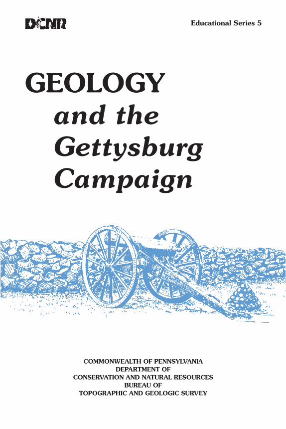
GEOLOGYand theGettysburgCampaign
COMMONWEALTH OF PENNSYLVANIADEPARTMENT OF
CONSERVATION AND NATURAL RESOURCESBUREAU OF
TOPOGRAPHIC AND GEOLOGIC SURVEY

COMMONWEALTH OF PENNSYLVANIAEdward G. Rendell, Governor
DEPARTMENT OFCONSERVATION AND NATURAL RESOURCES
Michael DiBerardinis, SecretaryOFFICE OF CONSERVATION AND ENGINEERING SERVICES
Larry G. Williamson, Deputy SecretaryBUREAU OF TOPOGRAPHIC AND GEOLOGIC SURVEY
Jay B. Parrish, Director
First Edition, September 1962Seventh Printing, Slightly Revised, March 1997
Eleventh Printing, June 2006

GEOLOGY
and the
Gettysburg Campaign
by Andrew BrownU.S. Geological Survey
Illustrations on cover and title page by Albert E. Van Olden
PREFACE
This booklet on Geology and the Gettysburg Campaignwas first published by our bureau in 1962 during the 100thanniversary of the Civil War. A crucial event in that great con-flict, the Battle of Gettysburg has special pertinence to Penn-sylvania and its citizenry. Since its first printing, the booklethas received widespread interest from tourists visiting the bat-tlefield, students of the Civil War, professional geologists, andothers who are fascinated by the interrelationship betweenthe local Gettysburg area geology, the terrain, and the courseof the battle.
We are most grateful to the author, Andrew Brown, a staffmember of the U.S. Geological Survey at the time of writingand an avid student of the Civil War, and to Dr. Robert C.Stephenson, former director of the American Geological In-stitute, for their permission to reprint this article, which ap-peared originally in the July-August 1961 issue of Geotimes,a professional news magazine of the geological sciences pub-lished by the American Geological Institute. Minor revisionshave been made to the original article.
It is our hope that the distribution of this booklet willbring a greater understanding of the importance of geologyand physical surroundings, not only with respect to the Battleof Gettysburg, but also with respect to the current problemsof the conservation and preservation of all of our great his-torical monuments and natural resources.

GEOLOGY AND THE GETTYSBURG CAMPAIGNEach year thousands of sightseers clamber over Little Round Top
and Devils Den on the Gettysburg battlefield, and gaze with awe overthe mile of treeless plain across which Pickett’s men charged toward“the little clump of trees” on July 3, 1863. All are impressed by therocky heights—the Round Tops, Cemetery Ridge, Cemetery Hill, andCulps Hill—against which Lee’s men hurled themselves in vain through-out three days of bitter fighting. Few, however, know that these heightsare the outcrop of a diabase sill, appropriately enough called the Gettys-burg sill, that about 200 million years ago intruded the Triassic sand-stones and shales that floor the broad Gettysburg plain. Even fewer haveany concept of the extent to which the movements of the two armiestoward Gettysburg, and the battle itself, were influenced by the geologyof the region in which the campaign was conducted.
The Gettysburg battlefield covers an area of about 15 square miles.The battle, however, was but the climax of a campaign that covered anarea of about 11,000 square miles. This area is approximately 140miles long—from Fredericksburg on the Rappahannock River in Virginiato Harrisburg on the Susquehanna River in Pennsylvania—and 80 mileswide—from a line drawn on the southeast through Fredericksburg, Wash-ington, and Baltimore, to the northwestern edge of the Great Valley of
1

Virginia, Maryland, and Pennsylvania (see Figure 1). A further idea of theimmensity of the military effort that reached its culmination in Pickett’scharge is gained from the mere fact that the campaign started on June 3at Fredericksburg, reached its climax on July 3 at Gettysburg, and didnot end until the Confederate army recrossed the Potomac into Virginiaon July 14.
At the time of the Civil War, the science of geology was young, andmilitary geology, as the term is understood today, was years in the future.Yet the principles of military geology, applied or all too often notapplied, influenced decisively the outcome of more than one campaign.The Gettysburg campaign is an excellent example of intelligent use bycommanders of both armies of terrain and topography and, therefore,of geology.
THE ADVANCE TO GETTYSBURGJune 3 to June 30, 1863
The region in which the Gettysburg campaign was conducted (Fig-ure 1) falls into four roughly parallel bands. From southeast to northwest,these are the Piedmont proper; the Triassic basins, including the Cul-peper basin in Virginia and Maryland and the Gettysburg basin in Mary-land and Pennsylvania; the Blue Ridge of Virginia and its continuation,South Mountain, in Maryland and Pennsylvania; and the Great Valley,including approximately the northern half of the Shenandoah Valley inVirginia, the Hagerstown Valley in Maryland, and the Cumberland Val-ley in Pennsylvania. Each of these four regions played a distinctive rolein the Gettysburg campaign.
After the campaigns of 1862, the Confederates went into winterquarters on the south bank of the Rappahannock River, the Unionarmies on the northern bank. The Rappahannock and its tributary, theRapidan, which joins it about 10 miles west of Fredericksburg, flow east-ward across the entire 50-mile width of the Piedmont in steep, easilydefended valleys, and were in effect the outermost defense line of Rich-mond. In this area, the Piedmont rises from approximately sea level atFredericksburg, Washington, and Baltimore, to about 400 or 500 feetnear the Blue Ridge. The exposed rocks, mostly of Precambrian age, aregranite, gabbro, and hornblende gneiss in the southeastern part and theWissahickon Schist in the northwestern part of the Piedmont. The rockyroads of this region of ridges and ravines were hard on men, animals,
2

3
Figure 1. Sketch map of the area covered by the Gettys-burg campaign.
and equipment, so were to be avoided by the armies of the sixties. Touse a term coined later by military geologists, the “trafficability” of theroads was poor. Although the Gettysburg campaign started in thePiedmont, both armies left it as soon as possible.
At Fredericksburg in December 1862 and at Chancellorsville inMay 1863, Union armies attempted, with disastrous results, to breachthe Confederates’ river lines. After his great victory at Chancellorsville,General Robert E. Lee, commanding the Confederate Army of NorthernVirginia, decided to invade Federal territory. He built up his army to astrength of 70,000 to 80,000 men (exact figures are impossible toobtain) and about 250 pieces of artillery. He divided his infantry intothree corps of about 20,000 men each. The First Corps was commandedby General James A. Longstreet; the Second Corps by General R. S.Ewell; and the Third Corps by General A. P. Hill. The cavalry, about10,000 strong, was commanded by General J. E. B. Stuart.
Facing the Confederates across the Rappahannock was the UnionArmy of the Potomac, about 100,000 strong, commanded by GeneralJoseph A. Hooker. Hooker had about 350 pieces of artillery; his infan-try was divided into seven corps, each approximately half the size of aConfederate corps; his cavalry, commanded by General Alfred Pleasanton,was about 13,000 strong.
Lee’s reasons for invading the North were political, military, andeconomic. Politically, the prospect of European intervention on the sideof the Confederacy would be greatly enhanced by a decisive victory onnorthern soil. The military objective was the capture of Harrisburg, thecapital of Pennsylvania. With Harrisburg in his hands, Lee could threatenPhiladelphia, Baltimore, or Washington as circumstances might makeadvisable, and he could also cut the Pennsylvania Railroad, a vital sup-ply line for the Union armies. Such a campaign was a sound if bold con-cept, particularly as Lee counted on outmarching the Army of the Poto-mac and meeting with no opposition except that of militia.
The economic reason for the campaign had to do with such mun-dane things as food, forage, horses, shoes—in fact almost everything anarmy needs except ammunition, with which the Confederates were wellsupplied. The Confederate commissary system, never good, had so bro-ken down that the army had no alternative but to “live off the country”—not in the friendly Shenandoah Valley, but in the hostile Hagerstownand Cumberland Valleys.
4

5
The Gettysburg campaign began on June 3, 1863. On that day,Ewell’s Corps of the Army of Northern Virginia left Fredericksburg,marching by way of Culpeper toward the Blue Ridge and the GreatValley. A glance at the map might give the impression that the Confed-erate commander was taking a roundabout route to Harrisburg, but itwas in fact the only practicable road. Lee, outnumbered as he knew hewas, could not hope to drive the Union army northward and across thePotomac by a frontal attack, but the situation was almost ideal for aflanking movement. Using the Blue Ridge as a barrier, and marching inthe wide, fairly level Great Valley, the Confederates were not only safefrom attack but to a surprising degree safe from observation. The BlueRidge and the Valley, therefore, were the keys to Lee’s strategy.
In Virginia, the Blue Ridge is high and rather narrow, formed oftightly folded and metamorphosed quartzite and volcanics, gneiss, andother resistant rocks mostly of early Paleozoic age. The crest of the ridgedrops from about 4,000 feet south of Thorntons Gap to 1,500 feet atthe Potomac, where it is known locally as Loudoun Heights. An exten-sion, Elk Ridge, continues about 10 miles into Maryland; the southernend of Elk Ridge is known as Maryland Heights. At the Potomac River,the main ridge is offset about 3 miles to the east, and an extension,Short Mountain, continues for about 10 miles into Virginia. Near theMaryland-Pennsylvania State line, a spur of South Mountain, the Catoc-tin Range, swings eastward and southward into Virginia, passing a fewmiles west of Frederick, Md. The Bull Run Mountains in Virginia are aninterrupted extension of the Catoctin Range.
South Mountain in Pennsylvania and northern Maryland is widerand more complex in structure than the Virginia Blue Ridge, though itis formed by the same rock types. Altitudes of the crest in that regionrange from about 1,500 feet at the Potomac to 2,000 feet near Carlisle.
Of military importance equal to the Blue Ridge and South Moun-tains were the gaps, which, so to speak, are the doors in the mountainwall. The only water gap in the area of the Gettysburg campaign is atHarpers Ferry where the Potomac River cuts through the mountains.The Harpers Ferry gap, however, is commanded by Loudoun Heights,Maryland Heights, and the high ground west of Harpers Ferry, andtherefore was of little military significance. The only places where thearmies of the sixties could cross the mountains were the wind gaps,eight of which influenced the campaign. From south to north, these are

Chester Gap (and Manassas Gap, about a mile to the north), AshbysGap, and Snickers Gap in Virginia; Cramptons Gap and Turners Gap(and Fox Gap, about a mile to the south) in Maryland; Fairfield (or Mon-terey) Gap near the Maryland-Pennsylvania State line; and Cashtown Gapand Carlisle Gap in Pennsylvania. Altitudes of these gaps range from600 feet at Manassas Gap to 1,400 feet at Cashtown Gap. The Virginiaand Maryland gaps are of erosional origin; Fairfield, Cashtown, and Car-lisle Gaps in South Mountain were formed by a combination of faultingand erosion.
After it became apparent, on June 15, that the Union army wasmoving northward and not toward Richmond, Longstreet’s and Hill’sCorps of the Army of Virginia followed Ewell’s Corps across the BlueRidge into the Great Valley using the three Virginia gaps, and thencenorthward. Lee’s concentration area, in and around Chambersburg, Pa.,was reached between June 24 and June 28.
In the Gettysburg campaign area, the Great Valley is from 10 to 20miles wide and averages about 15 miles. It is underlain by limestone andshale, mostly of Ordovician age, and owes its existence to the incom-petent nature of these formations as compared to the harder ridge-form-ing rocks on either side. In Virginia and West Virginia, the valley drainsnorthward through the Shenandoah River into the Potomac. The dividenorth of the Potomac is a few miles north of Chambersburg, standingat an altitude of about 650 feet. From that area, the Hagerstown Valleyis drained by Conococheague Creek, which flows into the Potomac atWilliamsport, Md. The Cumberland Valley drains northeastward into theSusquehanna at Harrisburg through Conodoguinet Creek.
The Great Valley was and is a fertile region, from which the Con-federates, once across the Potomac, impressed a vast quantity of sup-plies of all kinds. Because of the gentle grades and deep soil, the traffic-ability of the valley roads was good, and the Confederates reached Cham-bersburg in excellent condition.
Lee’s selection of Chambersburg as a concentration point was basedon the geology of Cashtown Gap. The other gaps in the northern partof South Mountain are narrow and tortuous; but Cashtown Gap, throughwhich U.S. Highway 30 now runs, owes its existence and character toa great cross-fault, the Cashtown fault, which offsets the topographiccrest of the main ridge of South Mountain about 3 miles. Erosion hascarved in the fault zone an almost straight pass about 8 miles long, thehighest point in which is a ridge less than a mile wide between the head-
6
waters of Conococheague Creek on the west and Marsh Creek on theeast. Of the eight passes that figure in the Gettysburg campaign, Cash-town Gap was the only one through which it was possible to move expe-ditiously a large force with artillery and wagon trains. By concentratingwest of this gap, Lee was able not only to protect his communicationsto the south, but to move either east or northeast over easy roads.
Lee held the initiative throughout his movement toward Gettys-burg, and therefore movements of the Union army were dictated bythose of the Confederates. The march across the Blue Ridge and into theValley was so well screened by Stuart’s cavalry that for a time Hookerhad little idea of where the Confederate army was or where it was going.He did, however, move slowly northward in the Culpeper basin and, onJune 25, crossed the Potomac. He then moved up the valley of the Mo-nocacy River to Frederick, sending three of his infantry corps to coverCramptons and Turners Gaps in South Mountain against a possible attackon Washington from that direction.
The exposed rocks in the Culpeper and Gettysburg basins aresandstone and shale that were deposited in Triassic time in the down-tilted western part of the Piedmont, which abuts the Blue Ridge andSouth Mountain. In Early Jurassic time, these sediments were intrudedby sills and dikes of diabase. As the roads generally avoided the diabaseoutcrops, trafficability across the Triassic sediments was good, much likethat in the Great Valley. Like the Confederates, the Union troops tookadvantage of geologic conditions to expedite their movements.
A critical day in the Gettysburg campaign, and possibly its turningpoint, was June 28. On that day, two of Lee’s three corps were concen-trated in the Chambersburg area. Two divisions of the third corps, Ewell’s,were at Carlisle, threatening Harrisburg from the west. The other divi-sion was at York, where it was in a good position to move toward eitherHarrisburg or Baltimore. From Lee’s standpoint, the campaign was pro-gressing favorably except for one fatal lack: the usually dependable Stuart,instead of keeping his cavalry between the Confederate and Union armies,had started a raid toward Washington, east of the Federals, and as far asLee was concerned, was lost. Because of Stuart’s unaccountable absence,it was not until the night of June 28 that Lee learned from a spy thatthe Union army had crossed the Potomac and was concentrated aroundFrederick. He therefore recalled Ewell’s troops from Carlisle and York andmoved Hill’s Corps through Cashtown Gap to Cashtown, to be in posi-tion to meet the Union threat.
7
General George G. Meade, commanding the V Corps, was awak-ened at 2 a.m. on that same June 28 and told that he had been namedto succeed Hooker as Commander of the Army of the Potomac. Meade,assuming command under most disadvantageous circumstances, actedpromptly. He recalled the three corps from Cramptons and Turners Gaps,and sent cavalry through Turners Gap to ascertain the Confederate posi-tion around Chambersburg. Knowing that Confederate troops were atCarlisle and York, Meade moved his headquarters to Taneytown and senthis engineers to select a strong defensive position, which later was tobecome known as the Pipe Creek line. He then sent three infantry corps,preceded by a strong cavalry screen, toward the town of Gettysburg,while the other four corps moved northeast and took position behindPipe Creek. Both movements were made on the basis of the geology ofthe areas concerned.
The Gettysburg basin, from its southern end near Frederick, widensnortheastward toward the Susquehanna River; in southern Pennsylvania,it is a wide, fairly level plain, except for the diabase outcrops. The townof Gettysburg, on this plain, was the hub from which radiated ten roads.Such was the road pattern that the Confederates, whether they camefrom Cashtown, Carlisle, or York, had no choice but to pass throughGettysburg. It was for that reason that Meade sent almost half his armytoward that little town.
Meade, however, did not want to fight at Gettysburg, desiring astronger position. The line which he selected, generally known as thePipe Creek or Westminster line, might be better described as the ParrsRidge line. Parrs Ridge, in the western edge of the Piedmont, extendsnortheast and southwest through Westminster. It forms the divide be-tween the Monocacy River drainage on the west and the direct drainageto the Chesapeake Bay on the east. The ridge near the Pennsylvania-Maryland State line stands at more than 1,000 feet above sea level, andat Westminster about 800 feet; this compares with the usual Piedmontelevations of 400 to 500 feet. Pipe Creek, flowing through the Triassicbasins north of the ridge and into the Monocacy River, is not particu-larly formidable, but Parrs Ridge, to the east, upheld by highly resistantschists and quartzites, has not only height, but widths of 4 to 10 miles thatcould have been fortified into an almost impregnable defensive position.
Although Meade never used his Pipe Creek line, his choice showshis good eye for geology and topography. Circumstances beyond hiscontrol brought the two armies together at Gettysburg.
8

9
THE BATTLE OF GETTYSBURGJuly 1 to July 3, 1863
The Battle of Gettysburg was essentially an effort by the Confed-erates to drive the Union army from the outcrop of the Gettysburg sill(York Haven Diabase) south of the town of Gettysburg. This outcrop isshaped like a fishhook extending northward about 3 miles from RoundTop through Little Round Top and Cemetery Ridge to Cemetery Hill,then east and south to the barb of the fishhook, Culps Hill. Round Top
Figure 2. Sketch map of the Gettysburg battlefield.

stands at 785 feet above sea level, Little Round Top at 650 feet. BetweenLittle Round Top and Cemetery Hill, the ridge drops to about 570 feet.For comparison, the elevation of the town of Gettysburg is about 500feet. Seminary Ridge, the Confederate position on the second and thirddays of the battle, stands throughout most of its extent at about 560 feet,but rises northward to 650 feet at Oak Ridge (see Figure 2). SeminaryRidge is the trace of a diabase dike (Rossville Diabase) that apparently isan offshoot of the westward-dipping Gettysburg sill.
One of the peculiarities of the Battle of Gettysburg is that the North-ern armies moved to the battlefield from the south, the Southern armiesfrom the north. The battle started, almost by accident and certainly againstthe wishes of both Lee and Meade, on the morning of July 1. GeneralA. P. Hill, thinking the town was held only by militia, authorized twobrigades to move into the town and obtain a supply of shoes reportedto be there. The two brigades were speedily disillusioned; once acrossWilloughby Run, they encountered dismounted cavalry and artillery,which they drove back about a mile. Then they met two infantry corpsthat had just reached the field and were themselves driven back. In themeantime, the remainder of Hill’s Corps and all of Ewell’s Corps werepouring into Gettysburg over the Cashtown, Carlisle, Harrisburg, andYork roads (see Figure 2). During the afternoon, these troops drove theoutnumbered Federals through the town of Gettysburg and to the baseof Cemetery and Culps Hills. Then occurred the first of a series of almostinexplicable Confederate blunders that marked the course of the battle.The Southerners were flushed with victory, the Union troops badly beaten,and enough of the long July daylight remained to storm the hills, whichcould not be protected by entrenchments because the diabase was prac-tically at the surface. Yet Ewell, who up to that time had performed ablyand even brilliantly as a corps commander, made no move to attack, andthe opportunity was lost. During the night, the positions were reinforcedso strongly that later efforts to take them failed.
Once the battle had started, the next phase was a race for the fieldby both armies. Of the Confederates, Longstreet’s Corps, except Pickett’sDivision, reached Gettysburg early on July 2; Pickett arrived about 24hours later. On the Union side, Meade moved all his infantry, except theVI Corps under General John Sedgwick, to the field by the morning ofthe second; Sedgwick arrived late in the afternoon. Thus, on the secondday of the battle, the Federals outnumbered the Confederates, reversingthe situation of the first day. Meade himself reached the field about 2 a.m.
10
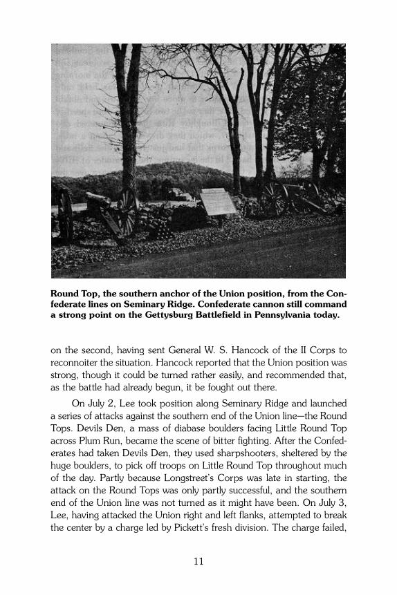
on the second, having sent General W. S. Hancock of the II Corps toreconnoiter the situation. Hancock reported that the Union position wasstrong, though it could be turned rather easily, and recommended that,as the battle had already begun, it be fought out there.
On July 2, Lee took position along Seminary Ridge and launcheda series of attacks against the southern end of the Union line—the RoundTops. Devils Den, a mass of diabase boulders facing Little Round Topacross Plum Run, became the scene of bitter fighting. After the Confed-erates had taken Devils Den, they used sharpshooters, sheltered by thehuge boulders, to pick off troops on Little Round Top throughout muchof the day. Partly because Longstreet’s Corps was late in starting, theattack on the Round Tops was only partly successful, and the southernend of the Union line was not turned as it might have been. On July 3,Lee, having attacked the Union right and left flanks, attempted to breakthe center by a charge led by Pickett’s fresh division. The charge failed,
11
Round Top, the southern anchor of the Union position, from the Con-federate lines on Seminary Ridge. Confederate cannon still commanda strong point on the Gettysburg Battlefield in Pennsylvania today.
partly at least because it was not supported on either flank, and theBattle of Gettysburg ended with the Federal army holding its position.
Almost until its end, the battle could have gone either way. Lackingthe services of the redoubtable “Stonewall” Jackson, dead these twomonths, and in the absence of Stuart, Lee did not have his army underfull control until July 2 and admittedly fought his worst battle. Meade,sound and methodical, won because he handled the Army of the Poto-mac better than it had been handled by any previous commander. It isironic that for this achievement he has received more blame than praise.
Meade has been criticized for preferring to fall back to his Pipe Creekline before meeting Lee. His reasoning was sound, however, for asHancock had reported, the heights could be turned. If Ewell, on July 1,and Longstreet, on July 2, had done what they should have done,Meade’s forces would have been outflanked, and there is good reason tobelieve that, had not the Confederate command system broken down,Meade would have been driven from the Gettysburg position. If that had
12
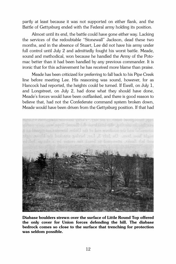
Diabase boulders strewn over the surface of Little Round Top offeredthe only cover for Union forces defending the hill. The diabasebedrock comes so close to the surface that trenching for protectionwas seldom possible.
happened, he would have had no choice but to fall back on his PipeCreek line.
The Union position at Gettysburg had another weakness that be-came more and more evident as the battle progressed; owing to thegeology, it could not be entrenched. The resistant diabase sill is so closeto the surface that it was impossible for the soldiers to “dig in,” and whatlittle protection they could obtain was provided by existing stone walls,outcrops of rock such as Devils Den, and isolated boulders. Because ofits inability to solidly entrench its position, the Union army suffered dis-proportionate casualties (about 23,000 men killed, wounded, and miss-ing), considering that it was the defending force throughout the battle.The Confederates suffered about 28,000 casualties, but spent three daysunsuccessfully attacking the Union line—first on the flanks and finally inthe center. When Union forces attacked well-entrenched Confederates atFredericksburg (December 1862) and Spottsylvania (May 1864), theylost about twice as many men as the Confederates—and at Cold Harbor(June 1864), more than four times as many. This is in accordance withthe axiom of infantry warfare that an attacking army must expect signi-ficantly higher losses than a defending force, which ordinarily will be en-trenched. Unlike the rocky Gettysburg line, Meade’s preferred position onParrs Ridge behind Pipe Creek could have been effectively entrenched.
THE RETREATJuly 4 to July 14, 1863
Throughout July 4, the two badly mauled armies faced each otheracross the field of Pickett’s charge, burying their dead and succoring theirwounded. Meade did not attack, though the Confederate position, likethe Federal, could not be entrenched to any appreciable degree. TheConfederate wounded and supply trains were sent westward throughCashtown Gap, while the main army prepared to retreat through SouthMountain at Fairfield Gap. On the fifth, the Federals followed, but decidedthat Fairfield Gap could not be forced. Accordingly, Meade sent his in-fantry south to Frederick and into the Great Valley through Turners Gap.Lee won the race to Williamsport, where he planned to cross the Poto-mac. There he fortified a strong line east of the town, anchored on thePotomac and on Conococheague Creek. Meanwhile the river had risen,and it was not until the night of July 13–14 that the Confederates were
13
able to cross on rebuilt bridges. Meade, who had planned to attack theConfederate works on the fourteenth, marched in to find empty forti-fications. He crossed the river and followed Lee south, and within a mat-ter of weeks both the Army of Northern Virginia and the Army of thePotomac were just where they had been on June 3—facing each otheracross the Rapidan River.
REFERENCESStose, G. W., and Bascom, F., 1929, Fairfield-Gettysburg folio, Pennsylva-
nia: U.S. Geological Survey Geologic Atlas of the U.S., Folio 225, 22 p.Stose, G. W., 1932, Geology and mineral resources of Adams County,
Pennsylvania: Pennsylvania Geological Survey, 4th ser., County Report 1,pt. 1, 153 p.
14

PENNSYLVANIA GEOLOGICAL SURVEYEDUCATIONAL SERIES
ES 1 Rocks and Minerals of PennsylvaniaES 2 Common Fossils of PennsylvaniaES 3 The Geology of Pennsylvania’s GroundwaterES 4 The Geological Story of PennsylvaniaES 5 Geology and the Gettysburg CampaignES 6 Pennsylvania and the Ice AgeES 7 Coal in PennsylvaniaES 8 Oil and Gas in PennsylvaniaES 9 Landslides in PennsylvaniaES 10 Earthquake Hazard in PennsylvaniaES 11 Sinkholes in PennsylvaniaES 12 The Nonfuel Mineral Resources of PennsylvaniaES 13 Reading and Using Maps
ADDITIONAL COPIES OF THIS PUBLICATIONMAY BE OBTAINED FROM
PENNSYLVANIA GEOLOGICAL SURVEY3240 SCHOOLHOUSE ROAD
MIDDLETOWN, PA 17057–3534717–702–2017
An Equal Opportunity Employer 2200–BK–DCNR3028Recycled Paper
