geology and underground waters of the … · eight miles northeast of artesia: gray, compact...
TRANSCRIPT

Water-Supply and Ration Paper No. 158 Senes { *
DEPARTMENT OF THE INTERIOR
UNITED STATES GEOLOGICAL SURVEYCHARLES D. WALCOTT, DIRECTOR
PRELIMINARY REPORT
ON THE
GEOLOGY AND UNDERGROUND WATERS OF THE ROSWELL ARTESIAN AREA
BY
GASBIUS A. FISHER
WASHINGTONGOVERNMENT PRINTING OFFICE
1906

CONTENTS.
Page.
Introduction..................................... 5Topography. ......... 5
Belief............................................................ 5Drainage . 5Lakes. ............................ 6
Outline of geologic relations. .......................... 6General statements. ........... 6Permian (?) series. ......... 6
Bed-bed division. ................. 6Limestone division. ........... 7
Cretaceous ('.') system. ................. 8Quaternary system. ......... 8
Alluvium ................ 8Unconsolidated deposits. ................. 9
Artesian water horizons. ....................... 9Extent of artesian area. ...... 9Wells and well prospects in Roswell artesian basin............. 10
General condition................... 10Chaves County. ............ 10
Boswell district ............. 10Hagerman district. ................... 13
Eddy County......................................................... 15Artesia district.................. 15McMillan district.................................................. 18
Pressure of artesian water. ................ 20Composition of artesian water.............. 21Origin of the artesian water ............... 23Amount of artesian water. ............. 24Waste of water. .................... 25Shallow wells.............................................................. 25Irrigation. ..................................... 26
Boswell system ............. 26Northern canal. ............ 26Hondo project......................................................... 27
Artesian irrigation.......................................................... 27Climate................................................................... 28
Temperature........................................................... 28Bainfall............................................................... 28
Agriculture................................................................ 29
3
ILLUSTRATIONS.
f^age. PLATE I. Map showing general location of the Roswell artesian area.............. 5
II. .A, Head of North Spring River; B, Head of South Spring River....._. 6III. A,Wie\f of "Bottomless Lakes," east of Pecos River; B, Artesian well and
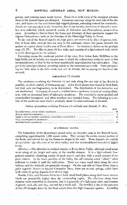
reservoir east of South Spring, New Mexico........................ 6IV. Reconnaissance geologic map of the Roswell artesian basin............. 8V. Geologic sections across the Roswell artesian basin.................... 8
VI. Map of the Roswell artesian basin................................... 10VII. A, Rasmussen's well, east of South Springs, New Mexico; B, Widdeman's
well, near Dexter, N. Mex........................................ 14VIII. A, Artesian town well, at Artesia, N. Mex.; B, Sherman's pumping plant,
near Roswell, N. Mex............................................ 16I.. Map of southeastern New Mexico, showing the general artesian conditions
of the Roswell basin............................................ 24
U. 8. GEOLOGICAL SURVEY WATER-SUPPLY PAPER NO. 158 PL. I
104
wr i c U---E4L wi/4_-_,.
105 C 104°
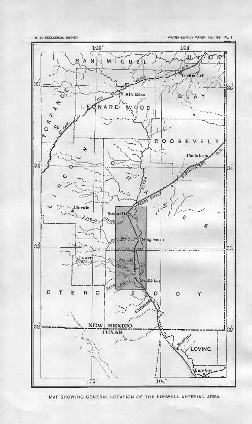
MAP SHOWING GENERAL LOCATION OF THE ROSWELL ARTESIAN AREA.

PRELIMINARY REPORT ON THE GEOLOGY AND UNDERGROUND WATERS OF THE ROSWELL ARTESIAN AREA, NEW MEXICO,
By CASSIUS A. FISHER.
INTRODUCTION.
The area to which this report relates is located in southeastern New Mexico. It comprises about 1,800 square miles lying along Pecos River and extending from a point 5 miles north of Roswell to below the mouth of Seven Rivers, as shown in PI. I. In addition to the discus sion of the artesian waters, the report includes a brief description of the geology of the sedi mentary rocks, their structure, and their relation to the underground waters. The area of flowing wells is indicated on the map, PI. VI, and records of representative wells are given, which are intended to illustrate the character and succession of the water-bearing beds) Information respecting surface waters available for domestic and irrigation purposes and a brief description of the climatic and agricultural features of the region are also given.
The investigation was conducted under the direction of Mr. N. H. Darton.The writer was assisted in the field by Messrs. E. M. Mitchell and E. Patterson, and these
gentlemen obtained a portion of the well data upon which this report is based. The system atic measurement of well pressures was carried on under the direction of Mr. W. M. Reed, district engineer of the Reclamation Service, who has done much to promote the work. The chemical analyses of the surface and artesian waters have been kindly furnished by Mr. E M. Skeats, of El Paso, Tex., and the paleontological collections have been examined by Dr. G. H. Girty. I am indebted to Messrs. Hagerman, Goodart, Phillips, Hortenstein, Spurlock, Hale, and others for information concerning artesian irrigation.
An excellent report on the soils of the Roswell basin by Messrs. T. H. Means and F. D. Gardner was used in the preparation of this report.
TOPOGRAPHY.
Relief. The topographic features of the Roswell basin present little variety. Across the east side of the district there are irregular bluffs rising 200 to 300 feet above Pecos River, while to the west the surface rises gradually toward the high limestone plateau bordering the Capitan, Sierra Blanca, and Sacramento mountains. The region has an average eleva tion of 3,600 feet above sea level. The highest portion is along the west side of the district, where the altitude is about 4,000 feet. In the southeast corner the altitude is about 3,200 feet. Near the junction of the North and South forks of Seven Rivers there is a high bluff having a north-facing escarpment, which rises high above the valley of the South Fork, and on the north side of Eagle Draw is a small but prominent plateau.
Drainage. The principal drainage channel is Pecos River, which enters from the north and flows in a southerly direction across the district. The flow is not large, but it carries a small amount of water during the entire year. There are a number of tributaries from the west, the largest being the Hondo, Felix, Penasco, and Seven rivers. Hondo and Penrsci rivers, perennial streams throughout their upper courses, have their sources high on the

6 ROSWELL ARTESIAN AREA, NEW MEXICO.
slopes of the Capitan, Sierra Blanca, and Sacramento mountains. The Felix and Seven rivers rise in the limestone plateaus lower down, and drain a much smaller area. Hondo Kiver east of Koswell is joined on the north by North Spring and Berrendo rivers, and on the south side near its mouth by South Spring River. These streams are fed by springs, and they carry abundant water at all seasons. There are also several small intermittent streams, which enter Pecos River. Those from the west are Gardners Arroyo, Fourmile Creek, Eagle Draw, Cottonwood Creek, Walnut Draw, and Zuber Hollow; those from the east are Coman- che Draw and Long Arroyo.
Lakes. At the heads of North and South Spring rivers and Middle and South Berrendo rivers are lakes of moderate size. These lakes are fed by a number of small springs, which derive their water mainly from the unconsolidated deposits underlying Hondo, Blackwater, and Eden valleys. Water rises to the surface in the lower courses of Felix River, Cotton- wood Creek, Penasco River, Gardners Arroyo, and North and South Forks of Seven Rivers. In the vicinity of Lake Arthur, Hagerman, Greenfield, and Dexter, and north along the east side of the Northern canal there are lakes fed in part by springs and in part by seepage from the Northern canal.
On the east side of Pecos River, about 12 miles southeast of Roswell, are several deep lakes lying along the base of the gypsum bluffs, which are locally known as the "Bottomless Lakes." Dimmit Lake, the largest of these, is situated at the head of a short ravine about 2J miles from Pecos River. Near the mouth of this ravine, on the north side, is Dee Lake, and along the base of the bluffs for some distance to the north several smaller lakes occur. The loca tion of these lakes is shown on the geologic map, PI. IV. They have probably been formed by flood water from the high slopes to the east, which, in flowing over the exposed gypsum ledges at the edge of the bluffs, has dissolved the gypsum and formed subterranean passages that now extend to some of the shallow artesian flows in Pecos Valley. A view of one of the " Bottomless Lakes " is shown in PL III, A. The water from some of these lakes is used for irrigation.
OUTLINE OF GEOLOGIC RELATIONS.
GENERAL STATEMENTS.
The rocks of the district comprise limestone, sandstone, clay, and gypsum which are believed to be of Permian age. Overlying these deposits throughout the Roswell basin are extensive sheets of sand, gravel, clay, and silt, probably of Quaternary age, which have been deposited in successive terraces between Pecos River and the high limestone slopes to the west. The so-called Permian series of this district consists of an upper red bed member of gypsum, red sand, limestone, and clay 600 to 800 feet thick, forming the high bluffs along the east side of Pecos River and underlying the recent deposits of Pecos Valley, and a lower member of massive limestone, clay, and gypsum of undetermined thickness, which constitutes high rugged slopes to the west. Overlying the red-bed division east of Pecos River is a reddish-brown sandstone about 100 feet thick, which may be of Cretace ous age. No subdivisions have been made of the probably Permian rocks in this region in the present reconnaissance.
PERMIAN (?) SERIES.
Red-bed division. These rocks consist o.' alternating beds of gypsum, red sand, and clay, with an occasional layer of dark-gray, compact limestone. The gypsum predominates and usually occurs in beds about 10 feet thick. It is often found, however, in thinner lay ers, interbedded with clay and limestone. The red beds are provisionally placed in the Permian, although no fossils have been found in them. They are not shown separately on the geologic map (PI. IV), but are represented with the underlying massive limestones. The upper part of the beds is well exposed in the bluffs along the east side of Pecos River, where a number of sections have been measured. These sections are as follows:

U. S. GEOLOGICAL SURVEY WATER-SUPPLY PAPER NO. 158 PL. II
A HEAD OF NORTH SPRING RIVER.
481
B. HEAD OF SOUTH SPRING RIVER.

U. S. GEOLOGICAL SURVEY WATER-SUPPLY PAPER NO. 158 PL. Ill
A. VIEW OF "BOTTOMLESS LAKES, EAST OF PECOS RIVER.
£. ARTESIAN WELL AND RESERVOIR EAST OF SOUTH SPRING, NEW MEXICO.

OUTLINE OF GEOLOGIC RELATIONS. <
Sections of gypsum Huffs along the east side of Pecos River, New Mexico.
East of Roswell: Feet.Alternating layers of gypsum and red sand, with an occasional layer of limestone.......... 50White gypsum................................................................................ 6Red sand..................................................................................... 6White, thin-bedded gypsum.................................................................. 10Red sandstone containing thin layers of limestone........................................... 24White gypsum................................................................................ 5Red sand..................................................................................... 13Gypsum...................................................................................... 10Red sand..................................................................................... 3Gypsum...................................................................................... 8Red sand..................................................................................... 8Gypsum...................................................................................... 4Greenish-gray sandstone..................................................................... 25Gypsum...................................................................................... G
Total..................................................................................... 178At Dimmit Lake:
Gray, sandy limestone........................................................................ 20Alternating layers of gypsum and red and green clay, with an occasional bed of porous lime
stone ....................................................................................... 100Gypsum...................................................................................... 4Red clay...................................................................................... 2JGypsum...................................................................................... 18Alternating layers of gypsum and red clay................................................... 6Gypsum...................................................................................... 11Alternating layers of gypsum and red sandstone............................................. 6Gypsum...................................................................................... 9Red clay...................................................................................... 1Gypsum...................................................................................... 10Alternating layers of gypsum and red clay. ................................................. 15Gypsum...................................................................................... 5Red clay.................T.................................................................... 1|Gypsum...................................................................................... 10Red clay...................................................................................... 7Alternating layers of gypsum and red clay................................................... 8Gypsum...................................................................................... fiRed clay, with thin layers of gypsum........................................................ 3Gypsum...................................................................................... 6
Total ................................................................................... 249Eight miles northeast of Artesia:
Gray, compact limestone..................................................................... 5Gypsum and red, sandy clay in alternate succession......................................... f>5Red, sandy clay.............................................................................. 10White, massive gypsum...................................................................... 15Red, sandy clay.............................................................................. 5White gypsum................................................................................ 10Gray limestone ............................................................................... 5Gypsum ...................................................................................... 18Red clay...................................................................................... 12Gypsum...................................................................................... 5
Total................................................................................... 150About 2 miles southeast of the mouth of South Fork of Seven Rivers:
Massive, gray limestone...................................................................... 35Gypsum and red sandstone in alternate layers, with an occasional limestone ledge......... 50Gypsum, thin-bedded porous limestone, and red sandstone arranged alternately, the gyp
sum predominating-........................................................................ 150Gypsum, with thin layers of gray limestone.................................................. 50
Total................................................................................... 285
Limestone division. The massive limestone beds underlying the so-called Permian red beds of this region consist mainly of gray, compact limestone, with layers of soft sand stone, clay, and gypsum. In the upper part the limestone is more or less thin-bedded and
8 ROSWELL ARTESIAN AREA, NEW MEXICO.
porous, and contains many sandy layers. From these beds some of the strongest artesian flows in the Roswell basin are obtained. Limestone outcrops along the west side of the dis trict, and farther to the west forms high rugged plateaus, extending toward the mountains. Fossils are not abundant in the formation, but in one locality northwest of Roswell a num ber were collected, which consisted mainly of Schizodus and Pleurophorus, preserved as casts. According to Doctor Girty the fauna and lithology of these specimens suggest the highest Carboniferous beds or the Permian of the Mississippi Valley in Texas.
To the east of the Roswell district the high plains are traversed by dikes of igneous rock. One of these dikes extends into the area in the northeast corner, but passes beneath the surface at a point about 5 miles east of Pecos River. Its location is shown on the geologic map (PI. IV). The dike is about 35 feet wide, and consists of a light-colored rock, which is much decomposed on the surface.
Extending across the southeast portion of the area, from below Lake McMillan to the high bluffs east of Artesia, is a narrow zone in which the sedimentary rocks are more or less metamorphosed, so that in the crevices considerable mineralization has taken place. Cop per is the principal mineral, occurring mainly as the carbonate and oxide. Some prospect ing has been done in the hills south and east of Artesia, but no paying ore has been dis covered.
CRETACEOUS (?) SYSTEM.
The sandstone overlying the Permian (?) red beds along the east side of the district is possibly, as above stated, of Cretaceous age. A few fossil plants were found in these beds, but they were too fragmentary to be determined. The distribution of the formation was not ascertained. It consists of massive, reddish-brown sandstone in beds of varying thick ness, with an occasional layer of light-gray sandstone. The material is coarse grained and cross-bedded throughout, and often weathers into rounded forms. The following is a sec tion of the sandstone near Petty's windmill, about 15 miles northeast of Roswell:
Section of sandstone overlying Permian (?) red beds near Roswell, N. Hex.Feet.
Reddish-brown, cross-bedded sandstone........................................................... 40Brown, massive sandstone......................................................................... 6Lighter brown, massive sandstone, somewhat cross-bedded ....................................... 10Gray, coarse-grained sandstone.................................................................... 1Reddish-brown sandstone ........................................................................... 18
QUATERNARY SYSTEM.
The formations of the Quaternary period cover an extensive area in the Roswell basin, comprising approximately 1,200 square miles. They occupy the entire central portion of the basin, and extend far up the limestone slopes to the west. These deposits are mainly of two kinds the alluvium of the river valleys and the unconsolidated material of higher levels.
Alluvium. The alluvium is confined mainly to Pecos River Valley, although small areas occur along all the larger and many of the smaller streams. It is a light-colored, fine grained material, consisting mainly of sand, gravel, and clay, with a small amount of or ganic matter. In the lower portions of the valley the soil contains much "alkali," often sufficient to render it unfit for cultivation. There are many small lakes along the river bottom, and the lowlands are generally swampy. On the east side of Pecos River, from a point opposite Dexter to beyond Comanche Draw, there are several springs, which have built cones of spring deposits 6 to 10 feet high.
Hondo, Felix, and Penasco rivers have built small flood plains along their lower courses which are perceptibly higher than the surrounding region. The alluvium along these streams varies somewhat in character, but it is generally of a light-gray color, and consists of gravel, sand, silt, and clay, covered by a fertile soil. The fertility is due to the presence of fine silt brought down by the flood waters from the high mountain rgeions. According

U.S. GEOLOGICAL SURVEY WATER-SUPPLY PAPER NO. 156 PL.IV
LEGEN D
Massive limestone, e,clay; and
RECO:NTSrAISS^NCE GEOLOGIC MAP OF THEARTESIAN BASIN,SOUTHEASTERN JSEWIMEXICO
BY C-A.FISHEIi
Walters and \Shaver wellPecosRiver
Walters and Shaver well
well
Hale well
Richey well
Si'gman well
lager man
Hedgecox well
Formwault well
Rasmussen well
Waskom well

EXTENT OF ARTESIAN AREA.
to Mr. T. H. Means the alluvium of Hondo Valley contains more plant food than that of the Nile in Egypt. The following analyses are taken from Mr. Means's report: a,
Chemical composition of Hondo and Nile sediment.
Constituent.Hondo mud
(Skeats) .
21.4
5.71.19
Nile mud (Mac
kenzie).
24.75.09
3.31
.68
Constituent.Hondo mud
(Skeats).
1.96.3
9.8.32
Nile mud (Mac
kenzie).
.62
.20
.211 f^
8.00.12
Unconsolidated deposits. These deposits consist mainly of sand, gravel, and clay. The sand is of light-gray color, medium to fine grained, the clay more or less sandy, and the gravel a moderately coarse variety. The gravel is often firmly cemented by calcium car bonate, and local deposits of gypsum and a calcareous material known as "caliche" occur throughout the formation. According to well records the thickness of the formation varies considerably in different parts of the basin. In several deep wells around Artesia coarse gravels were encountered 500 to 700 feet below the surface. At Eoswell and in the lower part of Hondo Valley unconsolidated sediments are 150 to 300 feet thick, and in Seven Rivers Valley they are probably thicker. In John Richey's well, 8 miles northeast of Artesia, a gravel bed, apparently the base of the unconsolidated sediments, was penetrated at a depth of 134 feet. At Sigman's well, near Lake Arthur, according to the driller's statement, the unconsolidated deposits are only a few feet thick, and about 3 miles north east of Lake Arthur the red, sandy beds of the Permian (?) are exposed.
ARTESIAN WATER HORIZONS.
There are several artesian horizons in the formations underlying the Roswell basin. Flows of moderate volume are found in the sandstones of the upper member of the Per mian (?) series and in the overlying unconsolidated deposits, but the strongest are from porous limestones interstratified with beds of sand, which constitute the upper part of t'ie massive limestone division.
EXTENT OF ARTESIAN AREA.
The Roswell artesian basin is about 60 miles long and has an average width of 11 miles. At the north end it is relatively narrow, but to the south it widens somewhat. It comprises about 650 square miles, the greater part of which lies along the west side of Pecos River. The area of flow is shown on PL VI.
In the vicinity of Roswell the head of artesian water, as determined both by practical tests and by the pressures of a number of flows in the town of Roswell, is sufficient to raise water to an altitude of 3,586 feet above sea level, the exact elevation of the water level in the head of North Spring River. In order to ascertain the western limit of the area of flow south of Roswell a line of levels was surveyed, under the direction of Mr. W. M. Reed, dis trict engineer, from the head of North Spring River as far south as Eagle Draw. From there to Seven Rivers the western boundary of the artesian basin was ascertained mainly from evidence of wells in the adjoining lowlands. It is possible that the artesian head increases to the west and that flows might be obtained higher up the slopes than is indicated on the artesian water sheet, especially in the valleys of Felix River, Cottonwood Creek, and Penasco River, but there appears to be no definite evidence of this. The eastern limits of the artesian area
« Means, T. II. and Gardner, F. D., Soil survey in the Pecos Valley: Field operations of Bureau of Soils, 1899, U. 8. Dept. Agric., Kept. No. 64. 1900, p. 49.

10 ROSWELL ARTESIAN AREA, NEW MEXICO.
are indicated by moderately high bluffs, which follow the general course of Pecos River across the entire district.
About 15 miles northeast of Roswell on the south side of Salt Creek are a number of springs that furnish considerable water. It is possible that shallow flowing w^ells would be obtained in the lowlands of Salt Creek Valley below these.springs, but no investigation was made of this region. At Stockpens, about 13 miles northwest of Roswell and a short distance south of the mouth of Salt Creek, a deep test well was being sunk at the time this investigation was made. The boring had reached a depth of 900 feet without obtaining a flow, but it was the intention of the well owTiers to continue to a depth of 1,000 feet. The head of artesian water in the northern part of the Roswell basin, as calculated from the pressures of flows in the vicinity of Roswell, is not sufficient to bring water to the surface in wells at Stockpens.
There is a deep well at Portales, N. Mex., in which a flow was obtained at a depth of about 400 feet. A record of this well is as follows:
Record of u-ell at Portales, N. Mex.Feet.
Soil............................................................................................. 0- 4Gypsum......................................................................................... 4- 8Red, sandy clay................................................................................. 8-20White limestone................................................................................. 20-32Red, sandy clay................................................................................. 32-48White limestone.......................................................'.......................... 48-88Red clav........................................................................................ 88-188
clay
WELLS AND WELL PROSPECTS IN ROSWELL ARTESIAN BASIN.
GENERAL CONDITIONS.
Flowing wells were first obtained in the Roswell basin about ten years ago and for a num ber of years thereafter development was confined chiefly to this immediate vicinity. Dur ing the last two years, however, strong flows have been obtained near Artesia, and at present this part of the basin is receiving the greatest development. Owing to the rapid progress in well sinking throughout the Roswell basin it is difficult to give a complete list of the flowing wells. Information of about 200 lias been obtained, but it is probable that the total number at present exceeds 250. About half of this number are found in Roswell and North Spring River Valley, the extreme north end of the basin.
In amount of flow the wells vary from a few gallons to 1,800 gallons a minute, differing principally with the locality. At Roswell the flow of an average well has been variously estimated at 500 to 700 gallons, while near Artesia the highest flow recorded exceeds 1,700 gallons. The water is used chiefly for irrigation and domestic purposes. In a few cases, however, the presence of sulphur renders it unfit for household use. The Formwaltz well northeast of Hagerman is said to have medicinal properties, but no chemical analysis of the water was obtained.
As the conditions under which artesian water is obtained throughout the Roswell basin show considerable variation, the area in the following discussion is divided into four dis tricts Roswell, Hagerman, Artesia, and McMillan. The Roswell and Hagerman districts are in Chaves County, and the Artesia and McMillan districts are in Eddy County.
CHAVES COUNTY.
Roswell district. This district comprises the northern portion of the area of flow included in Chaves County, and, as stated above, it is the district where greatest development lias taken place. In Roswell and in Hondo Valley the depths of the wells vary from 1-50 to 500 feet, the average being 250 feet. To the southeast in the vicinity of Orchard Park flows are

U.5.GEOLOGICAL SURVEY WATER-SUPPLY PAPER NO. 158 PL.VI
LEGEN D
te area of irri- n-Tvhiclnyater Dlvrise an deep £e>t oCthe surface
MAP OF THE ROSVTEJLL ARTESXAN BASIN SOUTHEASTEKlSr TSTEAV ME3CIC O
BV C.A.FISHERTopo^rapl^' compiled from rcdlroftd data-
Scale ? p t » ? 8 JO^mloa
Flowing weTLs

WELLS AND WELL PKOSPECTS. 11
obtained at a much greater depth. The formations encountered in sinking a well at Roswell generally consist of unconsolidated deposits for the first 175 feet from the surface. Below this depth drills penetrate bed rock, composed of hard, light-colored limestone underlain by alternating layers of porous limestone and sandstone. The following are records of repre sentative wells in and near Roswell:
Typical well record* in and near Roswell, N. Mex.
Record of the Ogle well at Roswell: Soil........... -.---..............
Feet. ..................................................................................... 0- 5
Gravel....................................................................................... 5- 30Blueish clay with layers of gravel........................................................... 30-150Greenish-yellow clay with rust-colored bands.............................................. 150-162Soft red sandstone (water bearing)......................................................... 162-170Red clay..................................................................................... 170-174Gray limestone.............................................................................. 174-177Red clay.................................................................................... 177-178Gray limestone.............................................................................. 178-182Gray limestone, very hard.................................................................. 182-180Soft gray limestone.......................................................".................. 186-204Hard gray limestone........................................................................ 204-218Light-gray, porous limestone (waterbearing).............................................. 218-226Limestone and sandstone in alternate layers (water bearing).............................. 226-242
Record of the Waskom well, SW. J see. 32, T. 10 S., R. 25 E.: a.Soil.......................................................................................... 0- 5Sand and gravel............................................................................. 5-15Yellow clay.................................................................................. 15-40Clay and decomposed gypsum.............................................................. 40- 70Sandstone, coarse yellow sand, and gravel in alternate succession.......................... 70-360Limestone and sandstone in alternating layers, the limestones predominating............. 360-5CO
Record of the Rasmussen well, SW. \ sec. 21, T. 11 S., R. 25 E.:Soil and fine sand...................:........................................................ 0-30Gray sand................................................................................... 30-40Gravel....................................................................................... 40-50Rock and gravel in alternate layers......................................................... 50- GORed sand................................................................................... 60-65Gray sand and hard rock in thin layers..................................................... 65-172uicksand................................................................................... 172-21:
Red sandstone.............................................................................. 212-327Red sand containing layers of rock......................................................... 327-400Limestone................................................................................... 400-560
Partial list of artesian wells in Roswell district, New Mexico.
Name of owner and location.
Anderson: SE. i sec. 3, T. 11 S., R. 25 E ..........................................
Do................................................................Do................................................................
"Bottomless Lake "well, SE. i NW. J sec. 10, T. 12 S., R. 26 E. ..........
Brink, Fritz, lot 14, block 23. west side Roswell- . ........................
Gaboon, E. A.: NW. JNW. isec. 34, T. 10 S., R. 24 E.. ...............................
Champion, D., NW. } NW. \ sec. 27, T. 10 S., R. 24 K ................:....
a In this well, located 4 miles east of Roswell, lied rock was reached 6 Mainly estimated.
Depth.
Feet.
006058
420232235938
229
330
at 11 def
Diame- yield b
Galls, perInches. minute.
0 ..........
0 ..........4 4006 ..........
4t 40''4 250
7| 300
th of 300 feet.

12 ROSWELL AETES1AN AREA, NEW MEXICO.
Partial list of artesian wells in Roswell district, Neiv Mexico Continued.
Name of owner and location. Depth.Diame
ter. Yield."
Feet. Inches.Chaves Co., block 11, Roswell............................................. 206Church, J. P., lot 8, block 45, West Roswell............................... 270Cottingham, J. A., lot 13, block 19, original Roswell...................... I 202 5Davis, W. P., SE. i NE. J sec. 7, T. 11 S., R. 25 E......................... 450 5|Denning, S. P., lot 8, block 51, west side Roswell......................... 240Diamond ice factory, lot 1, block 7, Thurber's addition, Roswell......... 196Dickson, J., northwest corner Washington and 2d sts., Roswell...... ... 270 5|Dickson, J. M., lot 5, block 52, west side Roswell......................... 198 5fDivers, F., lot 2, block 9, west side Roswell............................... 232Dunn, G., T. 12 S., R. 26 E ......................... ............... .....j 264Evans, J F., lot 8, block 28, original Roswell............................. 200 4Elliott Bros., SW. J SW. ^ sec. 32, T. 12 S., R. 25 E....................... 859 6Faulkner, R. L., lot 10, block 12, west side Roswell....................... 198 5Ferguson, W. M.:
Lot 10, block 2, original Roswell...................................... 255NE J NW. i sec. 15, T. 12 S., R. 25 E.................................. 882
Finley, M. N., SW. \ SW. i sec. 3, T. 11 S., R. 24 E....................... 354Fitzgerald & Kingston, lot 1, block 17, original Roswell..................' 200 5|Fitzgerald, lot 12, block 26, original Roswell............................. 190 5|Frank, C. J., lot 9, block 10, original Roswell............................. 202 5|Garrett, A. D., lot 1, block 20, west side Roswell......................... 260Garst, J., lot 2, block 1, original Roswell.................................. 271 3Garst, Julius, SE. J SW. i sec. 28, T. 10 S., R. 24 E....................... 279 6|Gaslin, H., lot 10. block 48, west Roswell................................. 242 4JGaullier, lot 6, block 1, original Roswell................................... 265 5|Goodart, J. H., NW. i NE. J sec. 7, T. 11 S., R. 25 E..................... 400 4;Hagerman, 0., lot 3, block 24, South Roswell............................. 405 5Hamilton, R. S., lot 12, block 14, original Roswell........................ 301Hamilton, J., SW. i SW. J sec. 26, T. 10 S., R. 24 E....................... 313Haynes, C. W.:
Lot 7, block 20, South Roswell........................................ 310Roswell............................................................... 232 5|
Do................................................................ 204Do................................................................ 232
Henning, J. H., lot 7, block 11, west side Roswell......................... 235 5Hinkle, J., lot 7, block 51, west side Roswe'l.............................. 235 4JHobson, Lowe & Co., lot 9, block 3, original Roswell...................... 270 5|Hortenstein, NW. ^ SW. i sec. 23, T. 12 S., R. 25 E........................ 840 5;Jaffa, N., lot 10, block 3, Thurber's addition, Roswell...................J 200 3Jaffa & Prager, lot 13. block 14, Roswell................................. J 380 4Johnson, R. W., lot 7, block 24, west side Roswell........................I 250 5fLawndes, G., NW. J NW. i sec. 35, T. 11 S., R. 25 E...................... 287Lea, J. C., lot 5, block 4, original Roswell................................. 230
{ooo
333 McCarty, S. S., N. J NW. i sec. 14, T. 10 S., R. 25 E............... ....... 844McClenney, M. E., SE. i SE. i sec. 35, T. 10 S., R. 24 E................... 375Marrow & Tannehill, lot 14, block 13, old Roswell........................ 260 5Meeks, W., lot 6, block 28, original Roswell............................... 160 4Miller, J., lot 4, block 30, original Roswell ................................ 230New Mexico Military Institute, Roswell .................................. 232 6|Parsons, R. M., lot 5, block 54, west side Roswell......................... i 245 5|Patterson, J. F., lot 1, block 42, west side Roswell........................ 260 J 3
"Mainly estimated.
Galls, per minute.

WELLS AND WELL PROSPECTS. 13
Partial list of artesian wells in Roswell district, New Mexico Continued.
Name of owner and location. Depth.
Feet.Peck, J. C,, NE. JSW. | sec. 27, T. 10 8., R. 24 E......................... 333Pecos Valley and Northeastern Railroad, Roswell (pressure 12 pounds).. 248Pettey & Miller, lot 6, block 14. original Roswell......................... J 225Pierce, F., lot 3, block 10, west side Roswell.............................. 264Rasmussen, E. P., SW. 1 fee. 21, T. 11 8., R. 25 E.. .'...................... 560Ray, J. R., lot 6, block 21, west side Roswell.............................. 221Read, G. W., lot 9, block 6, original Roswell.............................. 224Redderson, G., lot 11, block 18, west side Roswell......................... 250Ried, C. M., lot 3, block 12, west side Roswell............................. 175Roach T., lot 10, block 21, west side Roswell ............................. 250Roach, T. 8., lot 9, block 21, west side Roswell........................... 240Rogers, A. C., sec. 25, T. 10 S., R. 24 E.................................... 142Rose, I. B., lot 7, block 40, west side Roswell............................. 241Ross, F., lot 2, block 3, orig'nal Roswell..................................! 245Roswell Wood and Hide Co., lot 7, block 18, original Roswell............. 262Roswell (town):
Block 23, west side.................................................... 163Block 41, west side.................................................... 260Block 47, west side.................................................... 270
Seay, E.:Lot 8, block 38, west side Roswell..................................... 205Lot 11, block 38, West Roswell........................................' 170
Sheridan, C., lot 7, block 7, original Roswell.............................. 250Skipwith, J. H., lot 12, block 8, original Roswell.......................... 249Slakey, H. B., lot 9, block 57, west side Roswell.......................... 218Slaughter, C. C., sec. 34. T. 10 S., R. 24 E., Center......................... 275Slaughter, G., Thurber's addition, Roswell............................... 225Smith, L. R., SW. J NW. J sec. 27, T. 10 S., R. 24 E....................... 330Smock, W. S., lot 4, block 50, west side Roswell.......................... 235Spurlock, SW. i sec. 31, T. 11, S., R. 24 E.................................' 917Stansell.C. N., NE. J SW. J sec. 11, T. 11 S., R. 24 E...................... 340Stevens, L. A., lot 11, block 19, original Roswell.......................... 220Sutherland, lot 5, block 27, original Roswell.............................. 300Tipton, W.. lot 19, block 6, South Roswell................................ 300Totsek, S., lot 6, block 42, west side Roswell.............................. 238Veal, G. F., lot 10, blocks, original Roswell.............................. 361Waldron, C. E., lot 11, block 22, west side Roswell........................ 240Wallace, J. A., lot 5, block 39, west side Roswell.......................... j 155Warren, J. R., lot 1, block 23, west side Roswell.......................... 150Waskom, A. B., SW. J-sec. 32, T. 10 S., R. 25 E........................... 560Wells, W. F., lot 1, block 1, Roswell...................................... 230Whiteman, C., lot 1, block 6, Thurber's addition, Roswell................ 170Wilkenson, \V. G., lot 6, block 57, west side Roswell...................... 234Wilson, B., lot 8, block 44, west side Roswell............................. 235Woodruff & Hedgecoxe, lot 13, block 15, original Roswell................. 205Wyllys, G. L., lot 7, block 58, West Roswell.............................. 249Yater, B. M., lot 7, block 26, original Roswell (pressure about 7 pounds) . 203
Diame-
Galls, per Inches. t minute.
5f ! 400 820 750
5| 600
600400600300600500
2600500660
500600600
500400580500500550460300600324350360660
600600600200200756660400580600660780750
a Mainly estimated.
Hagerman district. In the immediate vicinity of Hagerman there are a few flowing wells, but about 8 miles north, near Dexter and in the lowlands east of Pecos River, there are several. They vary in depth from 300 to 1,000 feet, and the beds penetrated differ some what from those of the Roswell district. In the lowlands of Pecos Valley flows of moderate
IRK 158 06 2

14 ROSWELL ARTESIAN AREA, NEW MEXICO.
yield are obtained in soft sandstones at depths of 300 to 500 feet, but on the higher slopes to the west the main flow occurs in porous limestones 800 to 1,000 feet below the surface. The Hedgecoxe well, about 1 mile southeast of Dexter, is 960 feet deep. The main flow occurs in a porous limestone underlying red sandstone 60 feet thick, which is overlain by unconsolidated material.
The following records of wells were furnished by the drillers:
Typical deep borings in Hagerman district, New Mexico.
Record of the Hedgecoxe well, near Dexter: Feet.Soil and gravel........................................................................... 0- 19Coarse sand............................................................................... 19- 71Quicksand................................................................................ 71- 271Limestone................................................................................ 271- 273Red sandy clay........................................................................... 273- 323Yellow clay............................................................................... 323- 343Limestone................................................................................ 343- 345Quicksand................................................................................ 345- 545Limestone................................................................................ 545- 551Blue clay................................................................................. 551- 601Quicksand................................................................................ 601- 651" Shell rock"............................................................................. 651- 653Alternating layers of sand, silt, and clay................................................. 653- 800Coarse gravel............................................................................. 800- 806Red sandstone............................................................................ 806- 866Porous limestone......................................................................... 866- 960
Record of Widdem_:~i well:Stoil............................................................................^.......... 0- 20Gravel.................................................................................... 20- 55Quicksand................................................................................ 55- 105Alternating beds of clay and gypsum.................................................... 105- 360Sand...................................................................................... 360- 440Red sand with layers of clay and one 25-foot layer of gypsum near the middle........... 440- 800Limestone................................................................................ 800-lj 000
Record of Cummins well:Soil and gravel........................................................................... 0- 40Sand...................................................................................... 40- 44Clay...................................................................................... 44- 60Gravel.................................................................................... 60- 65Rock, clay, and sand in alternate layers.................................................. 65- 105Clay and sand............................................................................ 105- 165Red sand................................................................................. 165- 550Coarse red sand and clay in alternate layers............................................. 550- 820Limestone................................................................................ 820- 840
Partial record of town well at Hagerman:aSoil....................................................................................... 1- 12Conglomerate............................................................................. 12- 22Sand...................................................................................... 22- 32Clay...................................................................................... 32- 60Alternating beds of coarse sand and gravel.............................................. 60- 535Gypsum and red sandy clay in alternate beds ........................................... 535- 610Gypsurn.................................................................................. 610- 630Red clay and sand........................................................................ 630- 675Hard gypsum............................................................................. 675- 732Hard, gray sandstone.................................................................... 732- 735Gypsum.................................................................................. 735- 745Red clay and sand........................................................................ 745- 750Gypsum.................................................................................. 750- 760
a Boring in progress at time investigation was made.

U.
S.
GE
OL
OG
ICA
L
SU
RV
EY
A.
RA
SM
US
SE
N'S
W
EL
L,
EA
ST
O
F
SO
UT
H
SP
RIN
G,
NE
W
ME
XIC
O.
NO
. 15
8 P
L.
VII
B.
WID
DE
MA
N'S
W
EL
L,
NE
AR
D
EX
TE
R.
N.
ME
X.

WELLR AND WELL PROSPECTS. 15
Partial record of II. II. Sigman's well near Lake Arthur:Soil and conglomerate.........._._...__...._...___..__..........._..............._....... 0-Hard gypsum (first now at baseAlternating strata of gypsum and red sand.............................................. ISO-Alternating layers of red sand and day.................................................. 235-
Partial lixt <>j artesian irellx in Hagennan district.
Name of owner and location.
Carper, .1. K., NW. } NE. i sec. 28. T. 12 S., R. 20 E. ........................Casiers, T. M., NE. 1 NW. { sec. 7. T. 13 S., II. 2ii E ........................Clem, J. A., E. J sec. 11, T. 13 S.. K. 2(i E.. ..................................
Cummins, .1. Q.. SE. 1 sec. 33, T. 12 S., R. 25 E.. ............................ Elliot, I. II ................................................'..................
Goodell S W S 1 ^ec 15 T 13 S H '> > E
Greenfleld farm (center), sec. 32, T. 13 S., R. 2(i E. ..........................
Large, Frank: Sec. 4, T. 13 S., R. 26 E........................ ..........................Sec. 4. T. 13 S.. R. 20 E. ........................ .........................Sec. 4, T. 13 S., R. 2<i E. .................................................
Townsley, H. \V.: NW. i sec. 4, T. 13 S.. R. 20 E. ..........................................
NW. i sec. 4, T. 13 S., R. 2li E ...........................................
Walters, L., SE. } sec. 14, T. 13 S., R. 20 E. .................................Widdeman, NW. 1 sec. 5, T. 13 S., R. 20 E. .................................Wilson, P., NW. i sec. 18, T. 13 S., R. 27 E.......... ........................Winchell, N. J., SE. 1 SW. J sec. 30, T. 13 S., R. 20 E. ......................
1 Mainly estimated.
EDDY COUNTY.
Depth.
Feet.
330400525
800 700900
300839
700POO
1,000
375400
440
5051,000
020
DeS." -'Gallons
(per Inches, minute}. ........ 20
S 377Of ' 3517f 517 51 300
Of 250 4i ..........
7| 25
C5
10 764
K5 490
7 s iQQ
75 "iQQ
C5
5| , 310
........ 20
Artfnia district. The Artesia district comprises the northern portion of the area of flow included in Eddy County. The formations encountered in boring a deep well near Artesia differ somewhat from those in other parts of the Roswell basin. According to well records they consist for the first 500 to 700 feet of unconsolidated beds of sand, gravel, and clay, which by their loose texture frequently offer considerable difficulty in well construction. Beneath these beds there are alternating layers of red and gray sandstone, clay, and gyp sum lying on a scries of porous limestones, clays, and sandstones, in which the strongest artesian flows occur. A number of records of deep borings around Artesia, as reported by the well drillers, are here given:
« No satisfactory record, particularly of the lower part, could lie obtained of this boring, which was originally 1,000 feet deep. There is probably some defect in the casing of the well, for, according to the latest reports, the lower part of the pipe appears to be clogging up with sediment, and there is a perceptible decrease in the pressure of the flow. The best information which could be obtained con cerning the formations penetrated in the upper part of this well is here given.
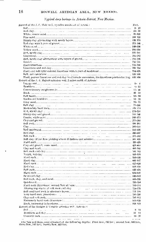
16 BO8WELL ABTESIAIST AREA, NEW MEXICO.
Typical deep borings in Artesia district, New Mexico.
Record of the .1. C. Hale well, 1J miles southeast of ArtesLi: Feet. Soil........................................................................................ 0-10Red clay.................................................................................... 10-30White, coarse sand......................................................................... 30-100Fine sand................................................................................... 100-120Bluish clay alternating with sandy layers.................................................. 120-375Red clay with layers of gravel.............................................................. 375-540White sand................................................................................. 540-550Yellow sand................................................................................ 550-556Red, sandy clay............................................................................ 556-581Limestone.................................................................................. 581-585Red, sandy clay alternating with layers of gravel.......................................... 585-745Gravel...................................................................................... 745-751Hard limestone............................................................................. 751-760Limestone and red clay..................................................................... 760-794Hard and soft light-colored limestone with layers of sandstone............................ 794-820Soft, red sandstone......................................................................... 820-830Hard, porous limestone and red clay in alternate succession, the limestone predominut ing. 830-850
Record of the J. S. Majors artesian well, 2 miles north of Artesia:Loamy soil................................................................................. 0- 6Bowlders.................................'................................................... 6-15Concretionary conglomerate................................................................ 15- 40Rock........................................................................................ 40-62Soft sands.................................................................................. 62-68Rocks and bowlders........................................................................ 68- 70Gray sand.................................................................................. 70- 72Soft clay.................................................................................... 72-160Moderately hard rock...................................................................... 160-174Red, sticky clay............................................................................ 174-210Sticky clay and gravel...................................................................... 210-240Coarse, white sand......................................................................... 240-275Clay and gravel............................................................................. 275-290Soft rock................................................................................... 290-295Clay............................................................................. -........... 295-310Red quicksand.............................................................................. 310-320Red clay.................................................................................... 320-357Soft rock................................................................................... 357-360Soft clay (First flow yielding about 10 gallons per minute)................................ 360-420Hard rock......................................^........................................... 420-428Clay and gravel; some sand................................................................ 428-460Clay and sand.............................................................................. 460-542Soft, rock and clay.......................................................................... 542-560Tough, red clay............-......................."......................................... 560-598Hard rock.................................................................................. 598-600Hard clay................................................................................... 600-617Hard rock.................................................................................. 617-628Red clay.................................................................................... 628-630Soft rock.................................................."................................. 630-634Hard rock. ................................................................................ 634-640Sand and clay.............................................................................. 640-6(i5Soft rock, clay, and sand................................................................... 665-700Quicksand.................................................................................. 700-704Harrl rock (limestone; second flow at base)................................................ 704-714Alternating strata of soft rock and clay.................................................... 714-770Soft and hard rock in alternate layers...................................................... 770-795Very hard rock (limestone)................................................................. 795-798Clay and soft rock.......................................................................... 798-812Extremely hard rock (limestone)........................................................... 812-820Rock, increasing in hardness............................................................... 820-823
Record of the Hodges & Venable artesian well, Artesia: aSoil........................................................................................ 0-10Bowlders and clay.. ....................................................................... 10- 19Concrete rock.................................... .......................................... 19- 26
a In this well flows were obtained at the following depths: First flow, 450 feet; second flow, 648 feet, thira flow, 785 feet; fourth flow, 802 feet.

U.
S.
GE
OL
OG
ICA
L
SU
RV
EY
A.
AR
TE
SIA
N
TO
WN
W
ELL,
AT
A
RT
ES
IA,
N.
M E
X.
WA
TE
R-S
UP
PL
Y
PA
PE
R
NO
. 15
8 P
L.
VII
I
B
SH
ER
MA
N'S
P
UM
PIN
G
PL
AN
T,
NE
AR
R
OS
WE
LL,
N,
M E
X.

WELLS ATSTD WELL PROSPECTS. 17
Record of the, Hodges & Venable artesian well, Artesia Continued. Feet. Loose gravel.............................................................................. 26 - 41Concrete rock............................................................................. 41 4(1Red clay.................................................................................. 46 73Concretionary gravel..................................................................... 73 - 76Loose gravel.............................................................................. 76 - 86Hard limestone........................................................................... 8fi -113Loose gravel containing water........................................................... 113 -120Limestone................................................................................ 120 -130Red clay.................................................................................. 130 -155Red clay alternating with conglomerate.................................................. 155 -185Alternating strata of concretionary conglomerate and red clay.......................... 185 -250Red clay.................................................................................. 250 -350Alternating layers of red. sandy clay and sandstone..................................... 350 -545Limestone, with an occasional layer of red clay, very hard at base of series............. 545 -840
Record of the J. B. Barnes artesian well, 12 miles southwest of Artesia:Soil....................................................................................... 0- 6Bowlders and gravel...................................................................... 6 - 13Yellow clay and gravel................................................................... 13 - 53Red clay.................................................................................. 53 -153Quicksand................................................................................ 153-157Red sand and soft sandstone............................................................. 157 -177Soft, yellowish sandstone................................................................. 177 -227Hard limestone........................................................................... 227 -267Red, sandy clay alternating with soft red sandstone, which gives place to porous lime
stone in the lower half of the series. (First flow)...................................... 267 -450Soft, red sandstone....................................................................... 450 -500Porous limestone......................................................................... 500 -525Soft, red sandstone................................. ..................................... 525 -535
Record of the S. L. Roberts artesian well, at Artesia:Soil....................................................................................... 0-7Bowlders and gravel...................................................................... 7 - 42Red, sandy clay containing some gravel.................................................. 42 -200Quicksand................................................................................ 200 -260Red clay................................................................................. 260 -300Alternating layers of gray sand and red clay............................................. 300 -600Limestone................................................................................ 600 -604Gypsum.................................................................................. 604 -634Red clay.................................................................................. 634 -675Limestone................................................................................ 675 -679Red clay.................................................................................. 679 -704Limestone................................................................................ 704 -705iRed, sandy clay.......................................................................... 705J-745JLimestone................................................................................ 745J-840Hard limestone........................................................................... 840 -852Red, sandy clay.......................................................................... 852 -880Limestone, porous........................................................................ 880 -976
Record of the E. N. Heath artesian well, 2 miles southwest of Artesia:Soil and clay.............................................................................. 0 - 15Gravel.................................................................................... 15 - 30Yellow clay............................................................................... 30-80Gravel and sand.......................................................................... 80 -280Sand...................................................................................... 280 -310Gravel and sand.......................................................................... 310 -340Hard, red clay............................................................................ 340 -344Gypsum.................................................................................. 344 -346Conglomerate............................................................................. 346 -366S.ind with thin streaks of gravel......................................................... 366 -441Coarse-grained, porous rock.............................................................. 441 -461Gray sand................................................................................ 4til -481Red quicksand............................................................................ 481 -631Rock...................................................................................... 631 -641Red quicksand............................................................................ 641 -691Hard, gray limestone..................................................................... 691 -715Red sand rock with streaks of clay....................................................... 715 -725Gray limestone, very hard................................................................ 725 -745

18 ROSWELL ARTESIAN AREA, NEW MEXICO.
Feet. 0- (i
Gravel...................................................................................... 76- MGypsum.................................................................................... 81-90Concretionary conglomerate................................................................ 90- 95Hard gray sandstone....................................................................... 95-106Red clay streaked with white clay......................................................... 106-120Dark-gray sandstone....................................................................... 120-157Yellow sand................................................................................ 157-100Hard gray sandstone....................................................................... 200-218Red sand................................................................................... 218-232\ ery hard light-gray sandstone............................................................ 232-244Red sand.................................................................................. 244-247Hard red rock.............................................................................. 247-250Red sand................................................................................... 250-268Hard red rock.............................................................................. 268-274Alternating strata of quicksand and soft red sandstone ..................................... 274-530
(In this series at 3S5 feet occurs the first flow; second flow at 475 feet.) Very hard limestone........................................................................ 530-540Red sandstone, medium hardness......................................................... 540-580
The greatest development in well sinking in this district is around Artesia, where a num ber of strong artesian flows have been obtained at depths of 800 to 1,000 feet. A partial list of these wells, including their location, depth, and size, is given in the following table:
Partial-list of artesian wells in Artesia district.
Name of owner and location.
Artesia (town). NE. \ NE. } sec. 17, T. 17 S., R. 26 E. 6. ....................
Barnes, .T. B., NW. \ NW. ] sec. 23, T. 18 S., R. 25 E... ..................... Bruce, J. A., NE. \ NE. 1 sec. 14, T. 17 S., R. 26 E. .........................C. A. P. Cattle Co., S\V. 1 NE. } sec. 23, T. 17 S., R. 20 E ...................Clark, W. E. c. ..............................................................
Hale, J. C., N\V. ^ SE. \ sec. 15, T. 17 S., R. 20 E. ........................... Harris, N. T., SW. \ SW. i sec. 14. T. 16 S., R. 2(i E.f. ......................
Hodges & Venahle, SE. i NW. }- sec. 23, T. 18 S., R. 2."> E ...................Majors, J. S., SW. i SW.J sec. 31, T. 17 S.. R. 26 E. .........................
Miller, L. C., SW. 1 SW. 1 sec. 8, T. 18 S., R. 26 E. ..........................
Norfleet, A. L., S. i NW. 1 sec. 32. T. 17 S., R. 26 E ......................... Rawl & Rohertson. sec. 5, T. 17 S.. R. 26 E .................. .............Richey, John, SW. } SW. \ sec. 11, T. 16 S., R. 26 E. 6 ......................Roberts, S. L., SE. \ SW. 1 sec. 8, T. 17 S., R. 26 E. .........................Smith, ,T. Mack, SW. i NW. \ sec. 29, T. 17 S.. R. 26 E ......................
Stanford, L. G., NE. i sec. 34, T. 18 S., R. 26 E .............................Walterschied, W. M., E. i SW. \ sec. 8, T. 17 S., R. 26 E ....................
Depth.
Feet.
53587-
830580570
820850
746
823
071
835
747
797795
Diam eter.
Inches. 66 5|
6
0
Cf
6
Yield.a
Galls, per minute.
1,548 562
320
1 , 168
1,110
1,044
1,725
a Mainly estimated. 6 92J pounds pressure. Incomplete. d 72J pounds pressure.
McMillan district. This district includes the area in the vicinity of McMillan and the valleys of North and South forks of Seven Rivers. Near McMillan the Walters & Shavers and the Lakewood Townsite companies' wells have strong flows from the porous limestone at depths of about 800 feet. The records of these wells indicate that the unconsolidated

WELLS AND WELL PROSPECTS. 19
sediments are about 250 feet thick and that the limestone division occurs 500 to oTK) ,'Wt below the surface. The records of these wells were supplied by the drillers ns follows:
Typical deep borings in McMillan district, New Mexico.
Record of the Walters & Shavers artesian well at McMillan: Feet.Soil......................................................................................... 0- 0Coarse gravel............................................................................... 0- 13White clay.................................................................................. 13-33Coarse sand and gravel containing water.................................................. 33- 43White chalky rock.......................................................................... 43- 70Very hard gray sandstone with layers of gravel............................................ 70-170Hard flinty rock............................................................................ 170-177Red clay and coarse gravel in alternate succession......................................... 177-235Light-colored sandy clay................................................................... 235-250Red clay.................................................................................... 250-254Alternating strata of gypsum and red clay................................................. 254-370Hard gypsum............................................................................... 370-393Series of gypsum alternating with red clay................................................. 393-440Alternating layers of white gypsum and red sandstone.................................... 440-500Red sand and hard sandstone in alternate layers 2 feet thick.............................. 500-f.50Hard white limestone....................................................................... 050-800Extra hard limestone....................................................................... 800-820White limestone becoming softer. (Flow of about 300 gallons)............................ 820-845
Record of the Lakewood Townsite Company artesian well at McMillan:Loam and gravel........................................................................... 0-49Soft gypsum in strata 5 to 6 feet thick..................................................... 49- SOWhite chalky rock.......................................................................... 80-120Sandstone and gypsum in alternating layers............................................... 120-135Pure white gypsum, moderately hard...................................................... 135-200Very hard white gypsum................................................................... 200-450Soft rock resembling shale.................................................................. 450-490Alternating layers of hard and soft white rock containing : few thin layers of sandstone.
(First flow at 770 feet, second flow at 810 feet)........................................... 490-863Very soft, white rock....................................................................... 803-877Alternating layers of soft and hard limestone.............................................. 877-880
In Seven Rivers Valley wells are generally shallow, ranging in depth from 150 to 300 feet, and the flows so far have been obtained from the unconsolidated rock. It is probable, however, that wells sunk to a sufficient depth in this region would obtain flows from the limestone division. A partial list of the wells in the McMillan district is given in the fol lowing table, and their location is shown on PI. VI:
Partial list, of artesian wells in McMillan. district.
Name of owner and location.
Brogden, J. C.:
Sec. 21, T. 20 S., R. 25 E .................................................Boyd, G. M., SE. i sec. 26, T. 19 S., R. 25 E .................................Cole, SE. isec. 7, T. 20 S., R. 25 E. .........................................
Hellyer, W. E ...............................................................
McDonald: NW. i sec. 8, T. 20 S., R. 25 E. ..........................................NW. Jsec. 8, T. 20 S., R. 25 E. ..........................................
Walters & Shavers, NW. \ NW. i sec. 23, T. 19 S., R. 26 E. .................
Depth.
Feet.
150?
400190
146150347845
Diam- ,,. , , eter. ^ lel(1
Galls, per inches, minute.
r^B ri73
5J 2535= ..........
6. 12(i ..........
5.1 75
0 300

20 ROSWELL ARTESIAN AREA, NEW MEXICO.
PRESSURE OF ARTESIAN WATER.
In connection with the investigation of the geology and underground water relations of the Roswell basin a systematic measurement of well pressures has been carried on. At the time when this investigation was proposed there appeared to be no evidence that the flow was decreasing, but it was feared that the multiplicity of wells within such a limited area would eventually lower the water plane unless greater economy was practiced by the water users. In arranging for the testing and comparison of pressures a number of representative wells were selected at different points throughout the basin, four from Roswell, where many have been sunk in a relatively small area, and others from near Hagerman and Artesia. In making these selections care was exercised to obtain only those which were believed to be representatives of local districts and in perfect condition. In a few instances, however, defective pipes were discovered after the first monthly pressure had been recorded. Careful measurements were taken of these wells each month under uniform conditions so far as pos sible. The result of this investigation extending over a period of twelve months is shown in the following table:
Record of periodic pressure measurements in pounds per square inch, of artesian wells in the Boswell artesian basin, New Mexico, for year ending May 31, 1905. a
No.
1
23
4
5
6
7
8
9
10
Name and location.
AETESIA DISTEICT.
Gilliland, *> SW. cor. SE. J sec. 19, T. 18 S.,
a |?3 3
t-'
3bo
V
1ft
< d5
^&o
O
R.26E.................................. 83 82 80 79Hale, <-NW. JSE. Jsec. 15, T.17S..R. 26 E. 88 87^7 84Hodges & Venable, 6 middle of west lino
SE. J NW. i sec. 23, T. 18 S., R. 25 E.... 311 311Norfleet, b NW. cor. of S. i NW. i sec. 32,
T. 17 S., R. 26 E .......................Richey, b SW. i NE. i sec. 14, T. 16 S., R. 26
E. .......................................HAGEEMAN DISTEICT.
Greenfleld farm,<J sec. 32(center), T. 13 S.,R.26E..................................
Sigman, H. H., 6 NW. J sec. 20, T. 15 S., R.58
26 E .........................................Widdeman, A. J.,6 SW. i SW. Jsec. 5, T. 13
S.,R. 26 E........... ....................EOSWELL DISTEICT.
Hagerman, J. J., b near center of west lineNW. 1 SE. J sec. 13, T. 11 S., R. 24 E . . . .
Hamilton, b lot 12, block 14 (original town-site), SW. 1 SW. i sec. 33, T. 10 S., R. 24
....
58
40
13 13i
301 30
621 61
57 57
140
13
E ... 6§ 62 7S11 McClenny, « SE. J SE. J sec. 35, T. 10 S., R.
40
131
7
24 E. ........ ......... .......... .... 16* 161 20 i 2012
13
14
Parsons, b lot 4, block 54 (west side) , NE. JSE. J sec. 32, T. 10 S., R. 24 E. ........
P. V. and N. E. roundhouse,/ NE. cor.NW. i SW. i sec. 33, T. 10 S., R. 24 E. . .
777
12 10Rasmussen, 6 SW. i NW. i sec. 21, T. 11 S.
25 E..... ......:......:................. 3115 Yater, 6 lot 7, block 26 (original townsite),
NE. 1 SE. \ sec. 32, T. 10 S., R. 24 E .....
31
7
10
31
7 7
f
12
31
7
8084
29
61
55
38
,0 t>» tia ii 03g 03 3 £ | _;>0fc
7982
27
58
3 >->
§ "oh
74 74
80 81,
£ i -C ft^
72^
771
25 25l! 24
55 56 54*
951 92 , 94 92i
531
41
41
134 134!
7 7§ _
53 i 53 54
33
41i
301 ....
391 39
131 134 14i
7 7? 8
20 21
7 7
12
31
7
12
321
7
20
7
21o
71
22
8
^
69771
21
a
In'c3
<£ o Oa H
169 -14
77J -101
21 -lOi
53 53 - 91
91 91 - 41
25 27 -14
39 39 - 1
134 131 + 1
8 8+14
211 21* + 4S
8
12 13 13 13
8 + 1
13+131
33 -
7
31 i 31J 311 + 1
7 10 ....1
10 +'3
a No measurements were obtained for December.6 Casings of Nos. 1, 4, 5, 7, 9, 10, 12, 14, and 15 were in perfect condition, or apparently so; slight leak
age at valve of Nos. 1, 3, and 8.c Decrease in pressure may be due to escape of water into a higher artesian horizon, which is reached
by a shallow well not far away.d This is an old well and the casing may be defective.t Low pressures in the months of June and July due to leakage in pipe./ Slight leakage in casing near surface and at valve caused a decrease of pressure in July and August
measurements.

PRESSURE AND COMPOSITION OF ARTESIAN WATERS. 21
In most cases in the Roswell and Hagerman districts, where the wells were in perfect condition, the pressures of the flows appear to ho substantially accordant, but around Artesia there are several wells in which the flows have materially decreased in pressure during the last twelve months. Without a thorough knowledge of the conditions under which artesian water is obtained around Artesia the decrease in pressure of sonie of the strongest flows in that vicinity might at first appear alarming, but a comparison of this district with that of Roswell, where there is no decrease in pressure, introduces many important factors which have a direct bearing on the case.
At Roswell artesian water is obtained at a depth of about 250 feet, and the. materials passed through offer practically no difficulty; as a result, very perfect wells are constructed. Then, too, in this region wells have been built for the last decade, and the well driller is so familiar with the conditions that he can predict with a fair degree of accuracy the materials to be encountered in sinking a well. Farther south in the basin, in the vicinity of Artesia, a successful artesian well is not so easily obtained. Here the main flow is reached at much greater depths, which range from 700 to 900 feet, depending on the loca tion. The increased depth is due to the presence of beds overlying the porous limestone series. They consist of red sand and gypsum of the supposed Permian series, and clay, fine sand, and gravel of the unconsolidated deposits. The sands predominate throughout and have often a loose texture familiarly known to the well driller as quicksand. This material is very difficult to drill through because of caving, and in one or two instances it was so troublesome that the owner was compelled to abandon the project. The pres sure at the surface in an average well around Artesia is about 80 pounds to the square inch, which means over 400 pounds to the square inch at the bottom of a well 800 _"eet deep. Such forces are difficult to manage, particularly where exploitation in the region has not been sufficiently extensive to enable the well driller to thoroughly acquaint him self with the nature of the obstacles to be encountered, and make suitable provision for them. The region is also one that offers considerable inducement to the ambitious well driller. As a result, new machines are constantly coming into this field, and the opera tors, though skilled in the art of well drilling, are entirely unfamiliar with this locality. It can readily be seen that under these circumstances imperfect wells are likely to result. Some of the strongest flows in the basin are and have been unmanageable since their com pletion, while others owing to unfavorable conditions are not working satisfactorily.
COMPOSITION OF ARTESIAN WATERS.
^General statements. The artesian waters of the Roswell basin are all more or less min eralized, but in only a few cases are the mineral constituents present in sufficient amounts to materially affect the taste or to be deleterious to plant growth. An average sample of the waters of North and South Spring rivers contains 75 parts of soluble matter to 100,000 parts of water. About two-thirds of the total solids consists of calcium carbonate and calcium sulphate, which are regarded as harmless to plants. The more soluble ingre dients of the water, consisting of sodium chloride, magnesium sulphate, and potassium sulphate, occur in amounts too small to injure plant growth if the ground is properly
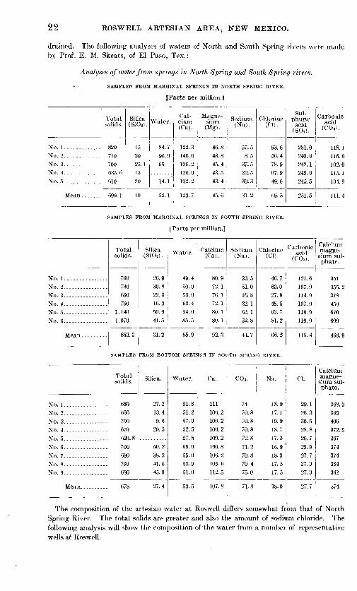
22 ROSWELL ARTESIAN AREA, NEW MEXICO.
drained. The following analyses of waters of North and South Spring rivers were made by Prof. E. M. Skeats, of El Paso, Tex.:
Analyses of water from springs in North Spring and South Spring rivers.
SAMPLES FKOM MARGINAL SPRINGS IN NOKTH SPRING KIVEK.
[Parts per million.]
No. 1.............No. 2....... ......No. 3.............
No. 4.............
Total solids.
820
710700635.0010
(i99. 1
Silica (Si02 ).
1520
'15
20
19
Water.
84.796.9
14. l"
52. 1
Cal cium (Ca).
122.3146. 6
126. 0
120.7
Magne sium (Mg).
46.848.8
43.5
45.6
Sodium(Na).
57.58.5
37.522.530.3
31.2
Chlorine (CD.
93.656.478 9
67.9
49.6
69. 3
Sul phuric
acid(S04 ).
240.6242.1245.6
Carbonic acid
(CO-i).
116.9102.0115.1
104 9
SAMPLES FKOM MARGINAL SPRINGS IN SOUTH SPRING RIVER.
[Parts per million.]
No. 1...............
No. 2................
No. 4.- ----.-....-.- -No. 5................No. ti................
Total solids.
700730
690790
1,140
1,070
853.3
Silica (SiOs).
26.9
30.899 3
16.050.0
41.5
31.2
Water.
49.450.053. 0Ii3.494.0
85.5
65.9
Calcium(Cai.
80.972.176.172.180.180.1
92.3
Sodium(Na).
23.551.016.832.162.152.8
44.7
Chlorine(Cl).
63.027.948.563.781.2
66.2
Carbonic acid
(COa).
107 9114 9107.9119 9
119.9
115.4
Calc.'um magne sium sul phate.
qc-i
occ 9
450
609
468 9
SAMPLES FROM BOTTOM SPRINGS IN SOUTH SPRING RIVER.
No. 1................No. 2.... ...-.-..-.--No. 3................
No. 5................
No. 7.... ............No. 8................No. 9. ......... ......
Total solids.
680650
700670620. 8
700
690700690
678
Silica.
27.213.49.6
20.5
50.238.341.645.0
27.4
Water.
51.8
51.257.0
52.5
27.8
55.055.0
53.951.0
50.5
Ca.
Ill
106.2106. 2106.2
109.2
106.8
106.2105.6
112.5
107.8
C0 3 .
7470.870.870.8
72.8
71.2
70.870.475.0
71.8
Na.
18.917.119.9
18.717.3
16.918.0
17.517.5
18.0
Cl.
29.1
26.330.528.8
26.7
25.9
27.727.027.0
27.7
Calcium magne sium sul phate.
368.0365406
374
374384362
374
The composition of the artesian water at Roswell differs somewhat from that of North Spring River. The total solids are greater and also the amount of sodium chloride. The following analysis will show the composition of "the water from a number of representative wells at Roswell.

COMPOSITION AND ORIGIN OF ARTESIAN WATEKS. 23
Analyse* of water front artesian irells at Roswell.
[Individual data. Harts per million.]
Silica.
48. 0 7(1. 1
69. 5 70. 1
86. 5 50. 1
91. 0 70. 135.54fi. 020.2
123.072.3
92.8182.0
33. 0
71.176.1
76. 970.1
63. 1
73.868.0
70. 1
CO..
113.9
94.9
83.9
113.9100. 4113.9115. 1 94.9
100. 4110.4 102.0
94.9
Mg. Na.
........ 160. 9
........ 114. 5
........ 44. 7
........ 92. 2
3. 9 96. 5........ 89. 8........ 86. 0 ........ 154.1
5. 67 111. 5
........ 106. 0
........ 183. 0
........ 150. 0
01.
247.6
170. 0
68.8
141.8
108.0138.2
133. 2 236.9171. 5
163. 0
230.0
Calciummag nesium
sul phate.
483 r>
395. 0
315. 0
316. 0466.0378. 0 641.0487. 5570. 5
472.0572. 0
The waters of the larger tributaries of Pecos River from the west, analyzed by Prof. E. M. Skeats, are reported to have the following composition:
Analyse* of water of the Hondo, Felix, North and South forks of Seven Rirers, and, Penascorivers.
Silica,River and location. T J!tul °\c --
solids. plus
Hondo (above Plea
Ca. Mg. Na.water.
1,195 80.7ch o).
Felix (head spring)... 407.2South Seven (head
spring).
North Seven (headspring). .
Penasco (by Gilberts)
18.8
231.9
CO.. S0<.
59.1 37.1 104. 3 622. 4
107.9 23.9 15.2 125.0 152.01,320.0 194.9 231.7 74.7 13.8 112.4 670.9
1,020.0 75.6
050. 0
104. 0 71. 8 38. 9
10. 0 136. 7 42.8 15.2
102.2
107.9
567. 7
324. 3
Tern- 01, pera-
59. 5
.:.' .23.3 ' 6421.3
19.8
06. 5
23.3 '.----.
Remarks.
Water fairlyclear.
Trace of hydrogen sulphide.
ORIGIN OF THE ARTESIAN WATER.
The water-bearing formations in the Roswell artesian area outcrop in successive zones on the higher slopes to the west. There they receive their water supply by direct, absorption from rainfall and by the sinking of streams (see PL IX). The Hondo, Felix, Penasco, and Seven rivers are the most important sources. These streams all rise high on the slopes of the Capitan, Sierra Blanca, and Sacramento mountains, where the rainfall is relatively large. As a result they carry an abundance of water in their upper courses, all of which sinks in the outcrop zone of the porous limestones and the overlying formations and passes underground to the east. After the water has entered these porous formations it is con fined by impervious layers of limestone or clay, and under the lower lands to the east it is under considerable pressure.
24 EOS WELL ARTESIAN AREA, NEW MEXICO.
AMOUNT OF ARTESIAN WATER.
It is difficult to make even an approximate estimate of the total amount of artesian water available in the porous formations underlying the Roswcll artesian area. We do not know definitely how much water is absorbed by the permeable rocks in their western out crop, and we are unable to calculate the amount which escapes through springs and by underflow along Pecos River.
The area drained by the larger western tributaries of Pecos River comprises in all about 4,000 square miles. It lies along the east slopes of the Capitan, Sierra Blanca, and Sacramento mountains. The location and extent of the combined watersheds of all streams supplying water to the underlying formations of the Roswell basin is shown in PI. IX. The annual precipitation for this general region is comparatively large, ranging from 10 to 20 inches. The mean annual precipitation at Fort Stanton, N. Mex,, which lies in the area drained by Hondo River, is about 15 inches. The average for seventeen years prior to 1891 was 19 inches, but from 1901 to 1903, inclusive, the annual rainfall was far below
.the average. The following table shows the result of observations through a period of nearly five years, ending with 1904:
Monthly and annual precipitation, in inches, at Fort Stanton, N. Mex.
Year.
1901.................1902.................
Jan.
0.10
Feb. Mar.
0. 05 0. as1903................. 0.30 0.75
0.220.17
Apr.
0.90
May.
1 09
June. July. Aug.
1.03 1.98 2 IS
0. 04 1. 34 ...... 1. 850.00 1.88 0.24 2.28 1.870.20 0. 38 3.41 0.02 1.55
0.03 0.15 0.14 ...... 2. 87 2.92
Sept. Oct. Nov.
0. 002.00
1.43
1. 70
0 40
Dec.
0. 30
2. 85 0. 950. 48 1. 81 0. 16 0. 571.55 0.48
2.680. 00 0. 05
An nual.
9.949. 52
At Lower Penasco, situated on the headwaters of Penasco River, the mean annual pre cipitation is about 18 inches, as is shown by the following table:
Monthly and annual precipitation, in indies, at Lower Penasco, N. Mex.
Year.
1896. ................ 1897. ................1898.................1899.................1900.-....--.-....... 1901................. 1909
Jan.
0.80 1.400. GOT.
0.90
Feb.
0.40 T.
0.250.20
0.30
Mar.
0.10
0.100.350.35
Apr.
T.0.501. 65
0.30 0.50
T.
May.
T.0.85
0.7001.70 1.15 0.35
June.
2.05 0.551.801.702.00 1.05
July.
3. 56 5. 607.405.89
4.85 6. 08
Aug.
1.38 3.154.001.351.95 0.97
Sept.
1.57 1.801. 152.90
5. 45 3.90
Oct.
0. 01 1.05T.
1.151. 05
Nov.
T. 0.100.301.50T.
Dec.
0.40 0.252.401.05
0. 00 T.
An nual.
16. 27
20.3510.09
20.05
From the above statements it is apparent that the total amount of water which falls during a year of average precipitation throughout the combined watershed of the Hondo, Felix, Penasco, and Seven rivers is necessarily large. Of course a portion of this water is lost by evaporation and run-off, but a considerable amount is absorbed by the water-bearing rocks and becomes available to the east as artesian water. It has not been practicable in the present investigation to compute the total outflow of all the artesian wells in the Roswell basin, but at a liberal estimate this amount would probably be only a small proportion of the quantity absorbed by the water-bearing rocks throughout their western outcrop area. This is clearly shown by the large number of wells which it has been possible to sink in the town of Roswell without materially diminishing the flows of some of the first wells dug. It is possible that the amount of artesian water available around Artesia is not so great as at

U.S.GEOLOGICAL SURVEY WATER-SUPPLY PAPER NO. 158 PL.IX
LEGEND
Approximate area,m which the priTt-
cipal -waterbearingrocks outcrop
Waterslie d of drain age which, crosses the outcrop area of
the water-bearing"beds
MAP OF SOUTHEASTERN NEW MEXICOSHOWING THE GENERAL ARTESIAN CONDITIONS
Bv C A. B-ISHKR
Artesian area
Contour interval 250 feet
1905
WASTE OF WATEE. 25
Roswell, hut the only evidence of this is the decrease in pressure of some of the wells at Artesia. The combined watershed of the streams lying west of this part of the basin is larger than that of Hondo River, and according to the Weather Bureau records it has a some what greater annual rainfall. For these reasons we would expect the formations underlying the southern part of the basin to contain a large amount of water. While there is evidence of a general decrease in flow throughout the Artesia district, it is probable that this diminu tion is largely due to the dogging of the pipes with sediment, the escape of water along the outside of the tubing from lower to higher horizons, and various other causes which are known to affect the flow of artesian wells.
It is believed that there is no cause for fear that the water supply throughout the northern part of the Roswell basin will give out or become inadequate for all requirements under proper economy of practice. In the region of Artesia and McMillan not enough wells have been sunk to indicate the amount that the water-bearing beds may be expected to yield.
WASTE OF WATER.
There is pressing need for greater econony on the part of the users of well water throughout the Roswell basin. At Roswell a city ordinance regulates the management of all flowing wells, but throughout the remainder of the district no restraint whatever is placed upon the management of the wells, and, with very few exceptions, they are allowed to flow continu ously. A small portion of this water is stored in artificial reservoirs, but by far the greater part runs off into pools, evaporates and seeps away on uncultivated lands, or runs directly into Pecos River. In one case noted a ditch leads from the well directly to the river, a dis tance of one-half mile, and it is not an unusual thing to find water flowing from the wells to low, marshy lands adjacent to the river, where by underflow it soon reaches the main channel. Formerly many of the wells were not even furnished with reservoirs, and the water was car ried by laterals directly to the fields during the irrigating season, and at other times was allowed to flow off through wasteways.
Nearly all the wells that are being constructed at the present time in the southern part of the basin are to be furnished with reservoirs ranging in capacities from 6 to 24 acre-feet, which are filled as often as necessary during the irrigating season. Even these commendable provisions are quite ineffectual in the case of wells not provided with valves, as they con serve only a relatively small portion of the total flow. An effort is now being made by a few of the well owners in the vicinity of Artesia to provide each well with a suitable valve, so that, when the water is not in use and the reservoir is full, the flow can be shut down. There is a general prejudice among well owners against shutting off the flow, as they fear that it will decrease the efficiency of the well. It is true that in a few cases wells have been damaged in this way, but where they were properly constructed the per cent injured is very small.
SHALLOW WELLS.
More or less water is obtained throughout the Roswell basin at depths varying from 25 to 200 feet. The water usually occurs in coarse gravel of the unconsolidated deposits. The supply appears to be inexhaustible, and in many cases the water is used for irrigation pur poses. Outside the area of flow from Roswell to Hagerman there are a number of wells 75 to 100 feet deep, which furnish 5,000 to 7,000 gallons of water a day. The water is generally pumped with windmills. In the vicinity of Roswell a few deep nonflowing wells are pro vided with gasoline engines. A gasoline pumping plant on Sherman's farm, at Roswell, is shown in PI. VIII, B.
Bordering the area of flows throughout the Roswell basin there is a zone of irrigable land 3 to 5 miles wide, in which water would probably rise in deep wells to within 100 feet of the surface, so that it could he profitably pumped for irrigation. The approximate limits of this area are shown on PI. VI.

2h ROSWELL ARTESIAN AREA, NEWr MEXICO.
The following list gives the principal features of a number of shallow wells in the northern part of the Roswell basin:
List of shallow wells in the Roswell basin.
Name of owner and location. Depth.
Feet.
Alhrecht, E, O.,NW. 1 sec. 32, T. 12 S.,R. 25 E ........................................ 88Alteberv.J. R.,S. i NW.i sec. 28, T. 11 S.,R.23 E. ................................... 208Bethel, H.,W.J N\V. i sec. 1,T. 17 S.,R. 25 E ........................................ 72
Brink, F.,E.| NW. i sec. 15, T. 11 S.,R. 23 E. ...................................... 12.5
Clark, J. H. : NW. 1 sec. 18, T. 17 S.,R. 26 E. ................................................... 38
Com, \V. AV. , SW. i SW. i sec. 35, T. 11 S. , R. 25 E ..................................... 42 Costa , N. , SE. 1 SE. 1 sec. 8, T. 11 S. , R. 24 E .......................................... 27
Gishwiller, J. A., SW. i sec. 18, T. 11 S. , R. 24 E ........................................ 71Hobbs, J. W ........................................................................ 58Ilobbs & Hanney, SE. i sec. 2, T. 11 S. ,R. 23 E ....................................... 77Hortenstein, SW. J sec. 23, T. 12 S. , R. 25 E ........................................... 102Miller , F. , T. 11 S. , R. 23 E ............................................................ 85
Millheiser,P.:
SW. i NE. I sec. 7, T. 11 S. , R. 24 E .................................. ..............' 175Paulson, P. O.,NW. 1 sec. 30, T. 13 S. , R. 20 K ......................................... ' 58Peck, J. C. , SE. 1 sec. 27, T. 11 S. , R. 23 E .............................................. IbO
Saunders, J. P. , SW. I NW. i sec. 8, T. 13 S. , R. 25 E ................................... 155Smith, E. L., T. 11 S. , R. 23 E ......................................................... 129
Stockard, J. W.:
White , G. A. , sec. 18, T. 14 S. , R. 26 E .................................................. 84Williams, O. L. , NE. \ sec. 7, T. 12 S., R. 25 E .......................................... 103
Amount pumped per day.
Gallons.
7,000
8,000
5,0006,0002,000
5,0007,000
7,000
7,000
6,0006,000
IRRIGATION.
Irrigation has been practiced to some extent in the Roswell basin since the first settle ments were made, but prior to 1889 only a few small farms were irrigated. The perma nent water supply in the vicinity of Roswell was the first to be utilized. Here a number of small ditches were dug, and by extending these ditches from time to time the present Roswell irrigation system has been developed. The Northern canal system, which irri gates the territory south of Roswell, was built by a development company as a part of a large irrigating project, designed to irrigate Pecos Valley from Roswell to the Texas- New Mexico line.
Roswell system. A number of ditches have been constructed from the head springs of Middle and South Berrendo' and North and South Spring rivers, which furnish water for the land along their valleys. The surplus water of these ditches is directed into the North ern canal to be used for irrigation farther down Pecos Valley.
Northern canal. This canal extends from Hondo River at a point about 5 miles east of Roswell to near Lake Arthur, a distance of about 35 miles, and irrigates a large district of well-improved farming land in the vicinity of Hagerman. Besides receiving water from

IRRIGATION. 27
the Berrendo and North and South Spring rivers, the Northern canal is supplied with water to some extent by artesian wells. Though the water of the Northern canal is highly mineralized from the large amount of seepage water which it receives in the vicinity of Roswell, the harmful salts apparently are not present in sufficient quantities to affect plant growth. The following analysis made by Prof. E. M. Skeats shows the average condition of the Northern canal water:
Analysis of Northern canal water.Parts per million.
Sodium (Nn )................................................................................... 256.1Sodium and potassium sulphates............................................................... 230.0Magnesium (Mg)............................................................................... 50. 4Calcium (Ca)................................................................................... 428.0Chlorine (CD .................................................................................... 393.9Carbonic acid (CO 3 )............................................................................ 101.9Sulphuric acid (SOt )............................................................................ 349. 7Silica, alumina, and iron (SiOjFezOaAlzOa)..................................................... 20.0Water of crystallization........................................................................ 190.0
Total solid................................................................................ 2.020.0
Hondo project. Preparations are now being made by the Government to store the flood waters of Hondo River for the purpose of irrigating lands along Hondo Valley above Ros well. The location of the proposed reservoir is in a high natural depression on the divide between Blackwater Arroyo and Hondo River. The surface rock in the vicinity is a mas sive blue limestone, weathering to light gray, underlain by alternate layers of gypsum and red and yellow clay. The bedding was originally uniform, but surface waters have dissolved the gypsum, causing a settling of the beds in the bottom of the reservoir and considerable local distortion around its rim. A number of borings were made with a dia mond drill in the bottom of the reservoir, in order to determine the character of the under lying rocks. The following is a record of one of these borings:
Record of diamond-drill boring, Hondo reservoir site, Neiv Mexico.Feet.
Clay.......................................................................................... 0 -11.1Broken limestone ............................................................................. 11.1-22Clay.......................................................................................... 22 -25Cavity........................................................................................ 25 -30Broken rock cavities.......................................................................... 30 -64. 4Gypsum...................................................................................... 64. 4-70. 2Clay.......................................................................................... 70.2-71.9Cavity........................................................................................ 71.9-73.4Loose rock.................................................................................... 73. 4-7(i. 8Gypsum...................................................................................... 76.8-79. 8Clay.......................................................................................... 79. 8-80.2Limestone.................................................................................... 80. 2-88. 4Gypsum..................................................................................... 88. 4-91. 8
ARTESIAN IRRIGATION.
The use of artesian water for irrigation in the Roswell area began soon after the first flowing wells were obtained, and it has been gradually increasing ever since. Irrigation from the waters of Hondo and North and South Spring rivers has been practiced, as pre viously stated, for many years, and the use of artesian water was not resorted to until most of the surface waters of the region had been appropriated. There are now several farms in the vicinity of Roswell that depend entirely on artesian water for irrigation, and to the south nearly all the land included in the area of flow has been filed on with the intention of reclaiming it by artesian irrigation. Many of the farmers in the vicinity of Roswell who have practiced artesian irrigation for several years have obtained results which are highly satisfactory. This has caused considerable interest and enthusiasm among those living farther south in the less developed portions of the basin, and in this region

28 ROSWELL ARTESIAN AREA, NEW MEXICO.
many large wells are now being sunk, which will be used exclusively for irrigation. Many of these wells are being provided with storage reservoirs, so that a larger amount of water will be available during the growing season.
Among many landowners throughout the area there is a tendency to overestimate the amount of land that can be irrigated from an ordinary artesian well. According to con servative estimates made by irrigators who have had considerable experience in this locality a flowing well with a yield of 450 gallons per minute, provided with a suitable storage reser voir, will irrigate 30 acres of alfalfa or 70 acres of orchard. In order to accomplish this, how ever, the land must have the proper slope and the soil must be of uniform texture. Alfalfa requires more water than any of the staple crops. Under ordinary conditions 30 inches per year is sufficient, but if the land is irrigated during the winter a larger quantity is re quired. If this amount of water is properly applied, three or four crops may be cut, the harvesting period ranging from May to the latter part of August. An average yield of alfalfa is 1 ton to the acre for each cutting.
It is difficult to make definite statements regarding the irrigation of orchards in this locality. It is accomplished in many different ways, depending mainly on the age and condition of the trees. In many instances vegetables are raised between the rows of trees, and no additional water is required for the irrigation of the orchard. It is generally suffi cient to water an orchard once a month during the summer and once, or possibly not at all, during the winter. About 15 to 20 inches of water a year is required.
CLIMATE.
Temperature. The climate of the Roswell basin does not differ materially in the pre vailing aridity from that of the remainder of southern and eastern New Mexico. The tem perature of the region is high, with a low relative humidity. The summers are usually long and hot and the winters mild and pleasant. The maximum temperature is 110° and the minimum seldom falls far below zero. The following tables compiled from the records of the United States Weather Bureau give the mean monthly maximum and minimum tem peratures of the Roswell district. The observations extend over a period of ten years, 1895 to 1904, inclusive:
Mean monthly temperature at Roswell, N. Hex.
Jan.
71.6
Feb.
78.65.4
Mar.
£5.418.4
Apr.
90.126
May.
86.938.5
June.
101.449.9
July.
99.256.8
Aug.
99.455
Sept.
97.341
Oct.
87.528.5
Nov.
81.517
Dec.
74.2
Rainfall. The average annual precipitation at Roswell is 16.6 inches. The greater part of this amount falls during the months of June and July in frequent showers, which, although often violent, are generally local and of short duration. Only a small percentage of the annual precipitation falls as snow. The following record of the monthly and annual pecipitation at Roswell, extending over a period of ten years, shows considerable variation:

CLIMATE ATSTD AGRICULTURE.
Monthly and annual precipitation, in inches, at RosweU, N. Mex.
29
Year. Jan.
1895................. 0.401896................. 0.601897. ................ 1. 121898 0 °6
1901................. 0.211902................. 1.24
1904. ................ 0. 16
Feb.
0.480.14
0
0.15
1.15
0.000 96
0.14
Mar.
0.020.02
0.59T.
0.000.83
0.00
Apr.
0.14T.
1.35
0.23
0.97T.T.
0.07
May.
2.310.123. 761.030.271. (12
1.040.70
1.30
June.
1.281 97
1.42
1.62
0.221.034.371.80
July.
4.45
1.792.786.534.37
3.045.52
1.23
Aug. Sept.
2. 99 1. 090. 40 1. 892. 94 1. 252. 99 0. 691. 21 3. 64
0.60 1.991. 80 3. 08
0 9°
0. 8.5 5. 10
Oct.
2.115. 46.44T.
0.20
2.211.36T.
2.67
Nov. Dec.
0. 85 0. 070 0.64T. T.
0. 50 1. 373. 21 1. 54
6. 15 0. 260.52 ' 0.50
0. 15 | 0. 30
An nual.
16.1913.1215.65
17.8416. 58
13.75
The heaviest rainfall ever recorded at Roswell was on October 31, 1901, when 5.65 inches fell in one night, causing considerable damage by flooding.
AGRICULTURE.
The general aridity of the climate renders farming without irrigation impracticable except in a few low-lying areas adjacent to Pecos River. In consequence agriculture is restricted to those portions of the valley where water can be obtained from some of the vari ous canals or from artesian wells. The cultivated portions of the basin at present com prise about one-eighth of the total area included in this report, the remainder being utilized for pasturage of cattle an industry to which the higher lands are well adapted. The chief products are alfalfa, Kaffir corn, wheat, oats, corn, potatoes, Mexican beans, cantaloupes, celery, and a large variety of garden vegetables. Alfalfa and Kaffir corn are perhaps the largest crops and both are consumed in the region. Fruit raising is a growing industry and many large orchards are found in the irrigated district. Peaches, pears, plums, cherries, and other small fruits have a hardy growth and an abundant yield, but the apple crop is the most important. At South Spring there is a large apple orchard, comprising about 600 acres, from which many thousand pounds of apples are shipped annually. Several large apple orchards have been planted during the last five years, and fruit raising seems destined to become one of the most important industries of the district. The seasons are ordinarily of sufficient length to insure the maturity of all cultivated crops.
IRR 158 06 3

CLASSIFICATION OF THE PUBLICATIONS OF THE UNITED STATES GEOLOGICALSURVEY.
[Water-Supply Paper No. 158.]
The serial publications of the United States Geological Survey consist of (1) Annual Reports, (2) Monographs, (3) Professional Papers, (4) Bulletins, (5) Mineral Resources, (6) Water-Supply and Irrigation Papers, (7) Topographic Atlas of United States folios and separate sheets thereof, (8) Geologic Atlas of the United States folios thereof. The classes numbered 2, 7, and 8 are sold at cost of publica tion; the others are distributed free. A circular giving complete lists may be had on application.
Most of the above publications may be obtained or consulted in the following ways:
1. A limited number are delivered to the Director of the Survey, from whom they may be obtained, free of charge (except classes 2, 7, and 8), on application.
2. A certain number are delivered to Senators and Representatives in Congress, for distribution.
3. Other copies are deposited with the Superintendent of Documents, Washington, D. C., from whom they may be had at prices slightly above cost.
4. Copies of all Government publications are furnished to the principal public libraries in the large cities throughout the United States, where they may be con sulted by those interested.
The Professional Papers, Bulletins, and Water-Supply Papers treat of a variety of subjects, and the total number issued is large. They have therefore been classified into the following series: A, Economic geology; B, Descriptive geology; C, System atic geology and paleontology; D, Petrography and mineralogy; E, Chemistry and physics; F, Geography; G. Miscellaneous; H, Forestry; I, Irrigation; J, Water stor age; K, Pumping water; L, Quality of water; M, General hydrographic investiga tions; N, Water power; O, Underground waters; P, Hydrographic progress reports. This paper is the eighty-first in Series B, the twentieth in Series I, and the fifty-first in Series O, the compete lists of which follow (PP=Professional Paper; B=Bulletin; WS=Water -Supply Paper):
SERIES B, DESCRIPTIVE GEOLOGY.
B 23. Observations on the junction between the Eastern sandstone and the Keweenaw series onKeweenaw Point, Lake Superior, by R. D. Irving and T. C. Chamberlin. 1885. 124 pp.,17 pis. (Out of stock.)
B 33. Notes on geology of northern California, by J. S. Diller. 1886. 23pp. (Out of stock.) B 39. The upper beaches and deltas of Glacial Lake Agassiz, by Warren Uphani. 1887. 84 pp., 1 pi.
(Out of stock.) B 40. Changes in river courses in Washington Territory due to glaciation, by Bailey Willis. 1887.
10 pp.,4 pis. (Out of stock.) B 45. The present condition of knowledge of the geology of Texas, by R. T. Hill. 1887. 94 pp. (Out
of stock.)B 53. The geology of Nantucket, by N. S. Shaler. 1889. 55 pp., 10 pis. (Out of stock.) B 57. A geological reconnaissance in southwestern Kansas, by Robert Hay. 1890. 49 pp., 2 pis. (Out
of stock.) B 58. The glacial boundary in western Pennsylvania, Ohio, Kentucky, Indiana, and Illinois, by G. F.
Wright, with introduction by T. C. Chamberlin. 1890. 112 pp., 8 pis. (Out of stock.)

II SERIE8 LIST.
B 67. The relations nf the traps of the Newark system in the New Jersey region, by N. H. Barton.1890. 82pp. (Out of stock.)
B 104. Glaciation of the Yellowstone Valley north of the Park, by W. H. Weed. 1893. 41 pp., 4 pis.(Out of stock.)
BIOS. A geological reconnaissance in central Washington, by I. C. Russell. 1893. 108 pp., 12 pis.(Out of stock.)
B 119. A geological reconnaissance in northwest Wyoming, by G. H. Eldridge. 1894. 72 pp., 4 pis.(Out of stock.)
B 137. The geology of the Port Riley Military Reseryation and vicinity, Kansas, by Robert Hay.1S96. 35 pp., 8 pis.
B 144. The moraines of the Missouri Coteau and their attendant deposits, by J. E. Todd. 1896. 71pp., 21 pis.
B 158. The moraines of southeastern South Dakota and their attendant deposits, by J. E. Todd.1899. 171 pp., 27 pis.
B 159. The geology of eastern Berkshire County, Massachusetts, by B. K. Emerson. 1899. 139 pp.,9 pis.
B 165. Contributions to the geology of Maine, by H. S. Williams and H. E. Gregory. 1900. 212 pp.,14 pis.
WS 70. Geology and water resources of the Patrick and Goshen Hole quadrangles in easternWyoming and western Nebraska, by G. I. Adams. 1902. 50 pp., 11 pis.
B 199. Geology and water resources of the Snake River Plains of Idaho, by I. C. Russell. 1902. 192pp., 25 pis.
PP 1. Preliminary report on the Ketchikan mining district, Alaska, with an introductory sketch ofthe geology of southeastern Alaska, by A. H. Brooks. 1902. 120 pp., 2 pis.
PP 2. Reconnaissance of the northwestern portion of Seward Peninsula. Alaska, by A. J. Collier.1902. 70 pp., 11 pis.
PP 3. Geology and petrography of Crater Lake National Park, by J. 8. Diller and H. B. Patton.1902. 167 pp., 19 pis.
PP 10. Reconnaissance from Port Hamlin to Kotzebue Sound, Alaska, by way of Ball, Kanuti, Alien,and Kowak rivers, by W. C. Mendenhall. 1902. P8 pp., 10 pis.
PP 11. Clays of the United States east of the Mississippi River, by Heinrich Ries. 1903. 298 pp., 9 pis. PP 12. Geology of the Globe copper district, Arizona, by P. L. Ransome. 1903. 168 pp., 27 pis. PP 13. Drainage modifications in southeastern Ohio and adjacent parts of West Virginia and Ken
tucky, by W. G. Tight. 1903. Ill pp., 17 pis.B 20S. Descriptive geology of Nevada south of the fortieth parallel and adjacent portions of Cali
fornia, by J. E. Spurr. 1903. 229 pp., 8 pis.B 209. Geology of Ascutney Mountain, Vermont, by R. A. Daly. 1903. 122 pp., 7 pis. WS 78. Preliminary report on artesian basins in southwestern Idaho and southeastern Oregon, by
I. C. Russell. 1903. 51 pp., 2 pis. PP 15. Mineral resources of the Mount Wrangell district, Alaska, by W. C. Mendenhall and P. C.
Schrader. 1903. 71pp., 10 pis. PP 17. Preliminary report on the geology and water resources of Nebraska west of the one hundred
and third meridian, by N. H. Darton. 1903. 69 pp., 43 pis. B 217. Notes on the geology of southwestern Idaho and southeastern Oregon, by I. C. Russell. 1903.
83 pp., 18 pis. (Out out stock.) B 219. The ore deposits of Tonopah, Nevada (preliminary report), by J. E. Spurr. 1903. 31 pp., 1 pi.
(Out of stock.)PP 20. A reconnaissance in northern Alaska in 1901. by P. C. Schrader. 1904. 139 pp., 16 pis. PP 21. The geology and ore deposits of the Bisbee quadrangle, Arizona, by P. L. Ransome. 1904.
168pp., 29 pis. WS 90. Geology and water resources of part of the lower James River Valley, South Dakota, by J. E.
Todd and C. M. Hall. 1904. 47 pp., 23 pis.PP25. The copper deposits of the Encampment district, Wyoming, by A. C. Spencer. 1904. 107 pp., 2 pis. PP 26. Economic resources of northern Black Hills, by J. D. Irving, with chapters by S. F. Emmons
and T. A. Jaggar, jr. 1904. 222 pp., 20 pis.PP 27. Geological reconnaissance across the Bitterroot Range and the Clearvvater Mountains in Mon
tana and Idaho, by Waldemar Lindgren. 1904. 122 pp.. 15 pis.PP 31. Preliminary report on the geology of the Arbuckle and Wichita mountains in Indian Terri
tory and Oklahoma, by J. A. Taff, with an appendix on reported ore deposits in the WichitaMountains, by H. F. Bain. 1904. 97 pp., 8 pis.
B 235. A geological reconnaissance across the Cascade Range near the forty-ninth parallel, by G. O.Smith and F. C. Calkins. 1904. 103 pp., 4 pis.
B 236. The Porcupine placer district, Alaska, by C. W. W'right. 1904. 35 pp., 10 pis. B 237. Igneous rocks of the Highwood Mountains, Montana, by L. V. Pirsson. 1904. 208 pp., 7 pis. B 238. Economic geology of the lola quadrangle, Kansas, by G. I. Adams, Erasmus Haworth, and
W. R. Crane. 1904. 83 pp., 1 pi. PP 32. Geology and underground water resources of the central Great Plains, by N. H. Darton. 1905.
433 pp., 72 pis. (Out of stock.)

SERIES LIST. Ill
WS 110. Contributions to hydrology of eastern United States, 1904; M. G. Fuller, geologist in charge.1905. -211 pp., 5 pis.
B 242. Geology of the Hudson Valley between the Hoosie and the Kinderhook, by T. Nelson Dale.1904. 63 pp., 3 pis.
PP 34. The Belavan lobe of the Lake Michigan glacier of the Wisconsin stage of glaciation andassociated phenomena, by W. C. Alden. 1904. 106 pp., 15 pis.
PP 35. Geology of the Perry Basin in southeastern Maine, by G. O. Smith and David White. 1905.107 pp., 6 pis.
B 243. Cement materials and industry of the United States, by E. C. Eckel. 1905. 395 pp., 15 pis. B 246. Zinc and lead deposits of northwestern Illinois, by H. F. Bain. 1904. 56 pp., 5 pis. B 247. The Fairhaven gold placers of Seward Peninsula, Alaska, by F. H. Moftit. 1905. 85 pp., 14 pis. B 249. Limestones of southwestern Pennsylvania, by F. G. Clapp. 1905. 52pp., 7 pis. B 250. The petroleum fields of the Pacific coast of Alaska, with an account of the Bering River coal
deposit, by G. C. Martin. 1905. 64 pp., 7 pis. B 241. The gold placers of the Fortymile, Birch Creek, and Fairbanks regions, Alaska, by L. M.
Prindle. 1905. 89pp., 16 pis. WS 118. Geology and water resources of a portion of east central Washington, by F. C. Calkins. 1905.
96pp., 4 pis. B 252. Preliminary report on the geology and water resources of central Oregon, by I. C. Russell.
1905. 138 pp., 24 pis. PP 36. The lead, zinc, and fluorspar deposits of western Kentucky, by E. O. Ulrichand W. S. Tangier
Smith. 1905. 218 pp., 15 pis. PP 38. Economic geology of the Bingham mining district of Utah, by J. M. Boutwell, with a chapter
on areal geology, by Arthur Keith, and an introduction on general geology, by S. F. Emmons.1905. 413 pp., 49 pis.
PP 41. The geology of the central Copper River region, Alaska, by \V. C. Mendenhall. 1905. 133 pp.,20 pis.
B 254. Report of progress in the geological resurvey of the Cripple Creek district, Colorado, by Walde-mar Lindgren and F. L. Ransome. 1904. 36 pp.
B 255. The fluorspar deposits of southern Illinois, by H. Foster Bain. 1905. 75 pp., 6 pis. B 256. Mineral resources of the Elders Ridge quadrangle, Pennsylvania, by R. W. Stone. 190.5.
86pp., 12 pis. B 257. Geology and paleontology of the Judith River beds, by T. W. Stanton and J. B. Hatcher, with
a chapter on fossil plants, by F. H. Knowlton. 1905. 174 pp., 19 pis.PP 42. Geology of the Tonoy»ah mining district, Nevada, by J. E. Spurr. 1905. 295 pp., 23 pis. WS 123. Geology and underground water conditions of the Jornada del Muerto, New Mexico, by
C. R. Keyes. 1905. 42 pp.. 9 pis.WS 136. Underground waters of Salt River Valley, Arizona, by W. T. Lee. 1905. 194 pp., 24 pis. PP 43. The copper deposits of the Clifton-Morenci district, Arizona, by Waldemar Lindgren. 1905.
375 pp., 25 pis.B 265. Geology of the Boulder district, Colorado, by N. M. Fenneman. 1905. 101 pp., 5 pis. B 267. The copper deposits of Missouri, by H. F. Bain and E. O. Ulrich. 1905. 52 pp., 1 pi. PP 44. Underground water resources of Long Island, New York, by A. C. Veatch and others. 1905.
394pp., 34 pis.WS 148. Geology and water resources of Oklahoma, by C. N. Gould. 1905. 178 pp., 22 pis. B 270. The configuration of the rock floor of Greater New York, by W. H. Hobbs. 1905. 96 pp., 5 pis. B 272. Taconic physiography, by T. N. Pale. 1905. 52 pp., 14 pis. (Out of stock.) PP 45. The geography and geology of Alaska, a summary of existing knowledge, by A. H. Brooks,
with a section on climate, by Cleveland Abbe, jr., and a topographic map and descriptionthereof, by R. U. Goode. 1906. 327 pp., 34 pis.
B 273. The drumlins of southeastern Wisconsin (preliminary paper), by W. C. Alden. 1905. 46 pp.,9 pis.
PP 46. Geology and underground water resources of northern Louisiana and southern Arkansas, byA. C. Veatch. 1906.
PP 49. Geology and mineral resources of part of the Cumberland Gap coal field, Kentucky, by G. H.Ashley and L. C. Glenn,in cooperation with the State Geological Department of Kentucky, C. J. Norwood, curator. 1906. 239 pp., 40 pis.
PP 50. The Montana lobe of the Keewatin ice sheet, by F. H. H. Calhoun. 1906. B 277. Mineral resources of Keiiai Peninsula, Alaska: Gold fields of the Turnagain Arm region, by
F. H. Moffit, and the coal fields of Kachemak Bay region, by R. W. Stone. 1906. WS 154. The geology and water resources of the eastern portion of the Panhandle of Texas, by C. N.
Gould. 1906. 64pp., 15 pis.B 278. Geology and coal resources of the Cape Lisburne region, Alaska, by A. J. Collier. B 279. Mineral resources of the Kittanning and Rural Valley quadrangles, Pennsylvania, by Charles
Butts.B 280. The Rampart gold placer region, Alaska, by L. M. Prindle and F. L. Hess. B 282. Oil fields of the Texas-Louisiana Gulf coastal plain, by N. M. Fenneman.

IV SERIES LIST.
WS 157. Underground \vaterin the valleys of Utah Lake and Jordan River, Utah, by G. B. Richardson. PP 51. Geology of the Bighorn Mountains, by N. H. Barton.\VS 158. Preliminary report on the geology and underground waters of the Roswell artesian area,
New Mexico, by C. A. Fisher. 1906. 29 pp., 9 pis.
SERIES O UNDERGROUND WATERS.
WS 4. A reconnaissance in southeastern Washington, by I. C. Russell. 1897. 96 pp., 7 pis. (Out ofstock.)
WS 6. Underground waters of southwestern Kansas, by Erasmus Haworth. 1897. 65 pp., 12 pis.(Out of stock.)
WS 7. Seepage waters of northern Utah, by Samuel Fortier. 1897. 50 pp.,3 pis. (Out of stock.) WS 12. Underground waters of southeastern Nebraska, by N. H. Darton. 1898. 56 pp., 21 pis. (Out
of stock.)WS 21. WTells of northern Indiana, by Frank Leverett. 1899. 82 pp., 2 pis. (Out of stock.) WS 2(i. Wells of southern Indiana (continuation of No. 21), by Frank Leverett. 1899. 64pp. (Out
stock.) WS 30. Water resources of the Lower Peninsula of Michigan, by A. C. Lane. 1899. 97 pp., 7 pis.
(Out of stock.)WS 31. Lower Michigan mineral waters, by A. C. Lane. 1899. 97 pp., 4 pis. (Out of stock.) WS 34. Geology and water resources of a portion of southeastern South Dakota, by J. E. Todd. 1900.
34 pp., 19 pis. WS 53. Geology and water resources of Nez Perces County, Idaho, Ft. I, by I. C. Russell. 1901. 86
pp., 10 pis. (Out of stock.) WS 54. Geology and water resources of Nez Perces County, Idalio, Pt. II, by I. C. Russell. 1901.
87-141 pp. (Out of stock.) \VS 55. Geology and water resources of a portion of Yakima County, Wash., by G. O. Smith. 1901.
68 pp., 7 pis. (Out of stock.) WS 57. Preliminary list of deep borings in the United States, Pt. I, by N. H. Darton. 1902. 60 pp.
(Out of stock.) WS 59. Development and application of water in southern California, Pt. I, by J. B. Lippincott.
1902. 95 pp., 11 pis. (Out of stock.) WS 60. Development and application of water in southern California, Pt. II, by J. B. Lippincott.
1902. 96-140 pp. (Out of stock.) WS 61. Preliminary list of deep borings in the United States, Pt. II, by N. H. Darton. 1902. 67 pp.
(Out of stock.)WS 67. The motions of underground waters, by C. S. Slichter. 1902. 106 pp.,8 pis. (Out of stock.; B 199. Geology and water resources of the Snake River Plains of Idaho, by I. C. Russell. 1902. 192
pp., 25 pis.WS 77. Water resources of Molokai, Hawaiian Islands, by Waldemar Lindgren. 1903. 62 pp., 4 pis. WS 78. Preliminary report on artesian basin in southwestern Idaho and southeastern Oregon, by I. C.
Russell. 1903. 53 pp., 2 pis. PP 17. Preliminary report on the geology and water resources of Nebraska west of the one hundred
and third meridian, by N. H. Darton. 1903. 69 pp., 43 pis. WS 90. Geology and water resources of a part of the lower James River Valley, South Dakota, by
J. E. Todd and C. M. Hall. 1904. 47 pp., 23 pis. WS 101. Underground waters of southern Louisiana, by G. D. Harris, with discussions of their uses for
water supplies and for rice irrigation, by M. L. Fuller. 1904. 98 pp., 11 pis.\VH 102. Contributions to the hydrology of eastern United States, 1903, by M. L. Fuller. 1904. 522 pp. WS 104. Underground waters of Gila Valley, Arizona, by W. T. Lee. 1904. 71 pp.,5 pis. WS 110. Contributions to the hydrology of eastern United States, 1904; M. L. Fuller, geologist in
charge. 1904. 211 pp.,5 pis. PP 32. Geology and underground water resources of the central Great Plains, by N. H. Darton. 1904.
433 pp., 72 pis. (Out of stock.) WS 111. Preliminary report on underground waters of Washington, by Henry Landes. 1904. 85 pp.
Ipl. WS 112. Underflow tests in the drainage basin of Los Angeles River, by Homer Hamlin. 1904.
55 pp., 7 pis. WS 114. Underground waters of eastern United States; M. L. Fuller, geologist in charge. 1904.
285pp.. 18 pis. WS 118. Geology and water resources of east-central Washington, by F. C. Calkins. 1905. 96 pp.,
4 pis. B 252. Preliminary report on the geology and water resources of central Oregon, by I. C. Russell.
1905. 138 pp., 24 pis. WS 120. Bibliographic review and index of papers relating to underground waters published by the
United States Geological Survey, 1X79-1904, by M. L. Fuller. 1905. 128 pp. WS 122. Relation of the law to underground waters, by D. W. Johnson. 1905. 55 pp.
SERIES LIST. V
WS 123. Geology and underground water conditions of the Jornada del Muerto, New Mexico, by C. R. Keyes. 1905. 42 pp., 9 pis.
WS 136. Underground waters of the Salt River Valley, by \V. T. Lee. 1905. 194 pp., 24 pis.B 204. Record of deep-well drilling for 1904, by M. L. Fuller, E. F. Lines, and A. C. Veatch. 1905.
106 pp.PP 44. Underground water resources of Long Island, New York, by A. C. Veatch and others. 1905.
394pp., 34 pis.WS 137. Development of underground waters in the eastern coastal plain region of southern California,
by W. C. Mendenhall. 1905. 140 pp., 7 pis.WS 138. Development of underground waters in the central coastal plain region of southern Califor
nia, by W. C. Mendenhall. 1905. 162 pp., 5 pis.WS 139. Development of underground waters in the western coastal plain region of southern Cali
fornia, by W. C. Mendenhall. 1905. 105 pp., 7 pis.WS 140. Field measurements of the rate of movement of underground waters, by C. S. Slichter. 1905.
122pp., 15 pis.WS 141. Observations on the groxmd waters of Rio Grande Valley, by C. S. Slichter. 1905. 83 pp.,
5 pis.WS 142. Hydrology of San Bernardino Vallev, California, by W. C. Mendenhall. 1905. 121 pp., 13 pis.WrS 145. Contributions to the hydrology of eastern Ignited States; M. L. Fuller, geologist in charge.
1905. 220pp., G pis.WS 148. Geology and water resources of Oklahoma, by C. N. Gould. 1905. 178 pp., 22 pis.WS 149. Preliminary list of deep borings in the United States, second edition with additions, by
N. H. Darton. 1905. 175 pp.PP 46. Geology and underground water resources of northern Louisiana and southern Arkansas, by
A. C. Veatch. 1906.WS 153. The underflow in Arkansas Valley in western Kansas, by C. S. Slichter. 19C6.WS 154. The geology and water resources of the eastern portion of the Panhandle of Texas, by C. N.
Gould. 1906. 64 pp., 15 pis.WS 155. Fluctuations of the water level in wells, writh special reference to Long Island, New York,
by A. C. Veatch.WS 157. Underground water in the valleys of Utah Lake and Jordan River, Utah, by G. B. Richardson.WS 15s. Preliminary report on the geology and underground waters of the Roswell artesian area,
New Mexico, by C. A. Fisher. 1906. 29 pp., 9 pis. The following papers also relate to this subject: Underground waters of Arkansas Valley in eastern
Colorado, by G. K. Gilbert, in Seventeenth Annual, ft. II; Preliminary report on artesian waters of aportion of the Dakotas, by N. H. Darton, in Seventeenth Annual, Pt. II; Water resources of Illinois,by Frank Leverett, in Seventeenth Annual, Pt. II; Water resources of Indiana and Ohip, by FrankLeverett, in Eighteenth Annual, Pt. IV; New developments in well boring and irrigation in easternSouth Dakota, by N. H. Darton, in Eighteenth Annual, Pt. IV; Rock waters of Ohio, by EdwardOrton, in Nineteenth Annual, Pt. IV; Artesian well prospects in the Atlantic coastal plain region, byN. H. Darton, Bulletin No. 138.
Correspondence should be addressed to
THE DIRECTOR,UNITED STATES GEOLOGICAL SURVEY,
APRIL, 1906. WASHINGTON, D. C.
o