geology of kartchner caverns state park, arizona · david h. jagnow - geology of kartchner caverns...
TRANSCRIPT

Copyright © 1999 by The National Speleological Society Journal of Cave and Karst Studies, August 1999 • 49
David H. Jagnow - Geology of Kartchner Caverns State Park, Arizona. Journal of Cave and Karst Studies 61(2): 49-58.
GEOLOGY OF KARTCHNER CAVERNSSTATE PARK, ARIZONA
DAVID H. JAGNOW
P.O. Box 93398, Albuquerque, New Mexico 87199 USA
Kartchner Caverns is developed entirely within the Mississippian Escabrosa Limestone in an isolatedfault block along the east flank of the Whetstone Mountains in southeastern Arizona. The geology of thecave, along with the detailed surface geology, was studied and mapped in preparation for commercialdevelopment of the cave. Seven black to dark-gray marker beds throughout the lower Escabrosa sectionprovided the key for unlocking the geology of Kartchner Caverns and the surface area. A 130 m mea-sured stratigraphic section shows the distribution of these key organic-rich marker beds. More than 60mapped faults cut Kartchner Caverns and probably date to the Miocene emplacement of the Kartchnerblock. Three geologic cross-sections illustrate how Kartchner Caverns developed near the 1408 m mslbase level, and then stoped upwards along faults to resistant ceiling beds. Kartchner Caverns has beenstable in its development for >50Ka.
This study of Kartchner Caverns during 1990 and 1991provides a detailed understanding of the geology in prepara-tion for the commercialization of this spectacular caveresource. Initially, the subsurface geology was mapped withinthe cave. Later, the author also mapped the Park’s surfacegeology. Key dark marker beds within the lower EscabrosaLimestone were used to tie the geology within the cave to thesurface geology. Marker beds were also used to calculate dis-placements on more than 60 faults cutting Kartchner Caverns.
Geologic cross-sections provided a better understanding ofwhere to locate the entrances of Kartchner Caverns for com-mercial development. Mapping of potentially hazardous ceil-ing blocks also helped determine the eventual layout of thecommercial trails. Structural analysis of the cave helped withthe understanding of how present-day water infiltrates the cavealong faults and fractures, and forms perched aquifers on topof impermeable marker beds. Detailed mapping of the faultsand fractured zones also helped determine where the tunnelexcavations would experience difficulties and additionalexpense. Understanding the geology of Kartchner Cavernsshould ultimately allow for better management of the cave.
Upon discovery in 1974, Kartchner Caverns had only onesmall entrance. Early explorers had to crawl 100 m and nego-tiate one tight squeeze before they discovered the Big Room(Tufts & Tennen 1999). To get to the Rotunda and ThroneRooms, explorers had to wade through waist-deep mud. Inorder to develop the cave for visitors, more-accessibleentrances and routes needed to be constructed. The preferredaccess points should lead conveniently to the cave’s key fea-tures, dovetail into a planned traffic pattern, and accommodatethe number of people that the cave can carry. Access pointsshould also be amenable to microclimate controls, structurallystable, easily excavated, and accessible to security supervision.A total of ten different locations were originally considered forpotential entrances.
Based on a weighted point system, three potentialentrances were finally selected for detailed geologic studies.
Each potential entrance was also considered for handicapped-accessible ramps, stairs, or elevators. Ultimately, the two cur-rent entrances were selected and successfully excavated. Thegeology of Kartchner Caverns, as presented in this paper,played a critical role in the selection of those entrances.
Figure 1. Surface geology of Kartchner Caverns StatePark as depicted by Creasey (1967). A portion of cross-sec-tion B-B’ is shown in Figure 2 (from Wruckel et al. 1983,with geology modified slightly from Creasey 1967.)

50 • Journal of Cave and Karst Studies, August 1999
14 • KARTCHNER CAVERNS STATE PARK SYMPOSIUM
REGIONAL GEOLOGIC SETTING
The regional geologic setting for Kartchner Caverns is bestillustrated by the Geologic Map compiled by Creasey (1967).The Whetstone Mountains, immediately west of KartchnerCaverns, are a simple monoclinal uplift of westward- to south-westward-dipping rocks. This north-trending uplift is brokenby relatively few faults, and exposes a more completePaleozoic section than any other range in southeastern
Arizona. The Whetstone Mountains are part of the highlyfaulted Basin and Range Province, which covers the south-western half of Arizona, and continues to the north and westinto Nevada and western Utah. Most of the ranges within thisprovince are bounded by north-trending horst and grabenfaults, and the intervening valleys are filled with thick Tertiaryand Quaternary sediments. Kartchner Caverns State Parkencompasses the majority of a down-dropped block ofPaleozoic rocks on the east flank of the Whetstone Mountains.
Figure 2. Structural geology cross-section B-B’ from Creasey (1967) showing relationship of Kartchner Caverns StatePark to the Whetstone Mountains to the west. Kartchner Caverns is in the Escabrosa Limestone (Me).
Figure 2 Legend:
Age: Geologic formations:Tertiary & Quaternary QTg = Gila Conglomerate. Locally includes capping of pediment gravels.
Cretaceous Kgs = fine-grained granodiorite sill
Lower Permian Pem = Epitaph Formation, middle limestone and marl member.Pel = Epitaph Formation, lower dolomite member.Pc = Colina Limestone.
U. Pennsylvanian PPe = Earp Formation.Middle & Phu = Horquilla Limestone, upper member.U. Pennsylvanian Phl = Horquilla Limestone, lower member.U. Mississippian or L. Pennsylvanian PMb = Black Prince Limestone.Mississippian Me = Escabrosa Limestone (contains Kartchner Caverns)Devonian Dm = Martin FormationCambrian Ca = Abrigo Limestone
Cb = Bolsa Quartzite
Precambrian pCa = Alaskite, includes aplite dikes.pCm = Quartz monzonite.pCp = Pinal Schist

Journal of Cave and Karst Studies, August 1999 • 51
KARTCHNER CAVERNS STATE PARK SYMPOSIUM • 15
Figure 1 shows the geology of this fault block as mapped byCreasey (1967). The mineral resource potential of this areawas further studied by Wrucke et al. (1983). Creasey’s cross-section B-B’ (Fig. 2) illustrates the structural nature of thisfault block. It is bounded to the west by a high-angle normalfault that has down dropped the Paleozoic section nearly 3.2km. Rocks in the low carbonate hills overlying KartchnerCaverns generally dip 15-35°SW (Fig. 2).
The area is actually much more faulted than indicated byCreasey, and has also been mapped by Thomson (1990).Kartchner Caverns lies entirely within the MississippianEscabrosa Limestone, contrary to Creasey’s map that showsthe entrance within the Horquilla Limestone.
GEOLOGIC MAPPING
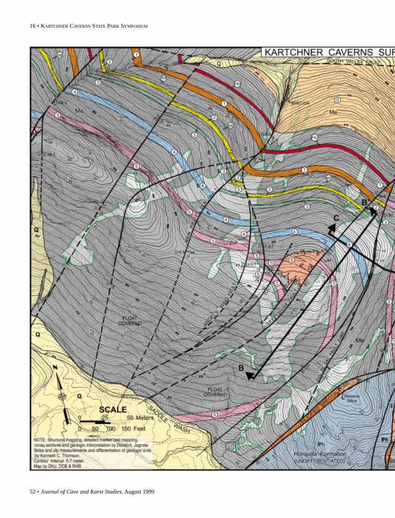
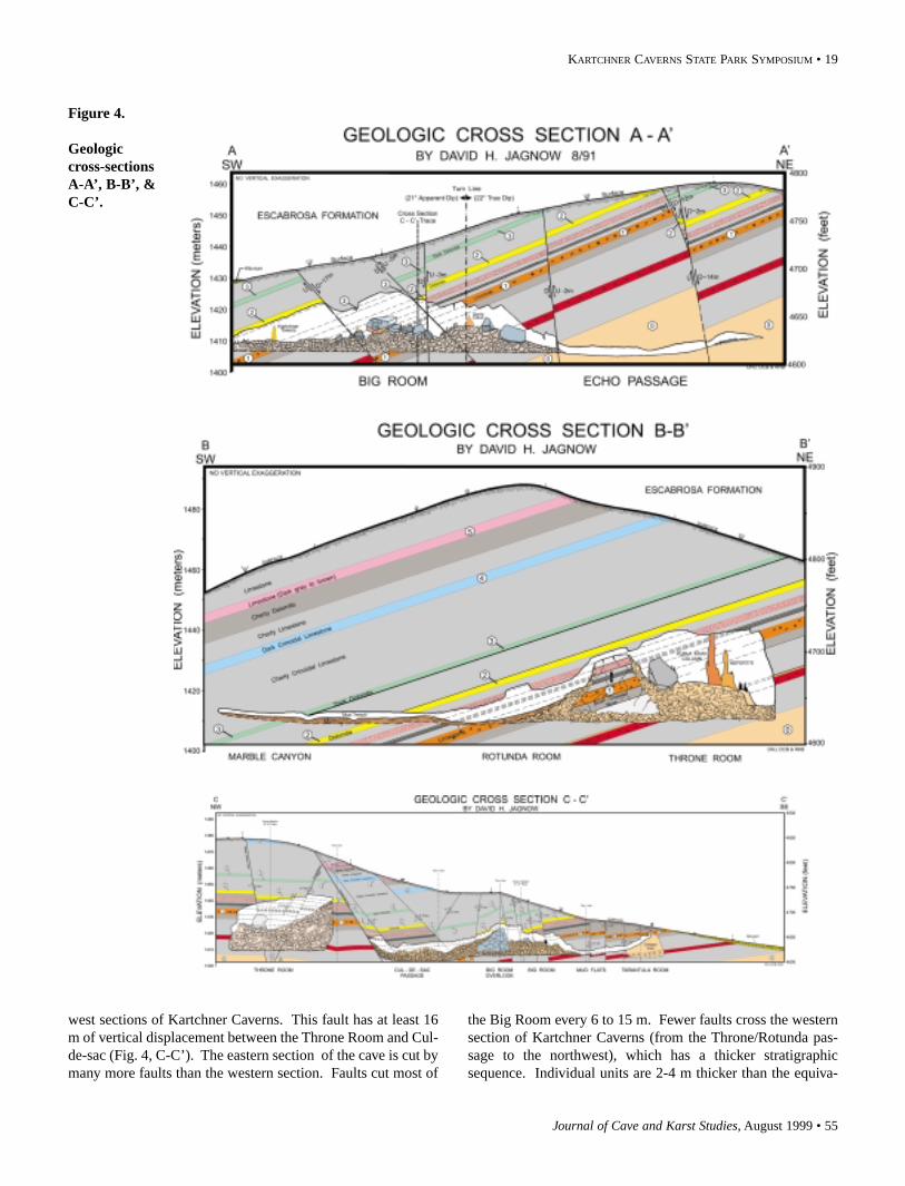
The author’s original report to Arizona State Parks includ-ed a subsurface geology map of Kartchner Caverns at a scaleof 1” = 50’, a subsurface stratigraphic section at 1” = 20’, andthree cross-sections, A-A’, B-B’, and C-C’, at 1” = 20’ (Jagnow1990). Original full-scale copies of these maps and cross-sec-tions are available through Arizona Conservation Projects, Inc.In 1991, the author constructed a detailed surface geology mapof Kartchner Caverns at a scale of 1” = 50’. The portion of thatmap directly over Kartchner Caverns is reproduced in thisreport at a smaller scale (Fig. 3). Upon completion of thedetailed surface geology mapping, cross-sections A-A’, B-B’,and C-C’ were revised slightly to more accurately tie togetherthe surface and subsurface features (Fig. 4).
MAPPING METHODS AND PROCEDURES
Mapping the geology inside a cave is often easier thanmapping the same geology on the vegetated surface because,except where obscured by secondary deposits, caves providethe geologist with an excellent three-dimensional, internalview of stratigraphy and structure and nearly “fresh” bedrocksurfaces. For these reasons, the subsurface geology ofKartchner was mapped first, and then expanded to the surface.While Thomson (1990) mapped the Escabrosa Limestone as asingle unit over all of Kartchner Caverns State Park, Jagnow(1991) mapped the detailed geology directly above KartchnerCaverns, subdividing the Escabrosa Limestone into multipleunits.
Strikes, dips, fault traces, and major fracture traces weresketched on the 1” = 50’ base maps during in-cave and surfaceinspections. The maps proved very accurate. Powerful bat-tery-operated spotlights and numerous photographs allowedgeologic mapping from existing trails within the cave.
STRATIGRAPHY
The Kartchner Caverns geologic section is so broken byfaults that there is no single location within the cave or on thesurface displaying an uninterrupted stratigraphic section. The
measured stratigraphic section (Fig. 5) was pieced togetherthroughout the cave and on the surface. Some surface loca-tions have complete sections, but are partially covered by talus.
Initial observations throughout the cave revealed a series of“black beds” (actually dark gray) that can be traced throughoutthe entire cave. These prominent dark beds have been mappedas key stratigraphic marker beds, designated by the numberszero (0) through five (5) in ascending order on Figure 5.Although similar in outward appearance, each bed has its owncharacteristic lithology and fossil assemblage, with distinctiveintervening sequences. These six beds, plus a horn coral bedbetween units zero and one (also colored), provided the keysfor mapping the entire cave and the detailed surface geology.
The measured stratigraphic section was established as fol-lows: 1) Powerful spotlights were used to examine the geolog-ic section along the northeast wall of the Big Room (within asingle fault block) and northeast wall of the Throne Room (Fig.6). Bed thicknesses were estimated and coloration was accu-rately described. 2) The identical section was then located andmeasured on the surface, immediately east and north of thecave. This allowed for accurate lithologic description and foran additional measured section above the Big Room section.3) Additional section was described throughout the RiverPassage and out to Granite Dells. The abundance of faults inthis area made it difficult to accurately determine thicknessesof this upper portion of the section. 4) Photographs were takenshowing the bedding and faults in the Big Room and ThroneRoom. 5) Laser cross-sections were made through the BigRoom and Throne Room, pinpointing the location of all promi-nent beds. This provided accurate thickness measurements, aswell as the dip of the bedding plane ceilings. 6) Laser cross-sections were combined with the photographs and surfacedescriptions to produce the detailed stratigraphic sectionshown in Figure 5.
Kartchner Caverns is developed in 69 m of theMississippian Escabrosa Limestone. The thickness of specificbeds varies throughout the cave, and a range of thicknesses isgiven for some of the more studied units. The lowest portionof the geologic column (marker bed 0) is exposed in EchoPassage and Pirate’s Den, along the northeast side of the cave.The highest portion of the stratigraphic section (marker bed 5)is located in Granite Dells, the southwestern extremity of thecave.
Figure 5 shows the minimum thickness of beds, and assuch, best represents the measured section in the Big Room orfront section of the cave. The bedding thicknesses in the backsection of Kartchner Caverns (Throne Room, Rotunda Room,and beyond) are consistently thicker than in the front section ofthe cave. The entire section thickens to ~82 m as indicated oncross-sections B and C. These differences will be described inmore detail in the discussion of the cross-sections, but mayindicate a substantial amount of strike-slip movement alongthe fault zone between the Throne Room and Cul-de-sacPassage.
The key stratigraphic marker beds, 0 through 5, each have
52 • Journal of Cave and Karst Studies, August 1999
16 • KARTCHNER CAVERNS STATE PARK SYMPOSIUM

Journal of Cave and Karst Studies, August 1999 • 53
KARTCHNER CAVERNS STATE PARK SYMPOSIUM • 17
Figure 3.
Detailed sur-face geologyof KartchnerCaverns.

54 • Journal of Cave and Karst Studies, August 1999
18 • KARTCHNER CAVERNS STATE PARK SYMPOSIUM
distinctive lithologies (Fig. 5). All of the units appear black inthe cave due to a high percent of organic matter. When broken,the rock yields a “fetid odor”; i.e., smelling faintly like oil. Onthe surface, these units are more easily eroded, forming slopesbetween the adjacent cliff-forming limestones and dolomites.Most of these dark beds are aquicludes, unable to absorb waterbecause of the high organic content within the rock. Theyserve as perched aquifers, with water seeping into the cavealong the top of each bed, commonly forming rows of stalac-tites from the bed. Within the cave it is often impossible todetermine the character of a bed if it is well out of reach on thecave ceiling or wall. Therefore, the unique interveningsequences above and below each marker bed often determinedstratigraphic position.
Figure 7 is a wide-angle photograph and overlay interpre-tation of the northeast wall of the Big Room. It shows markerbeds 1, 2, and 3, as well as the fault interpretation, and thelocation of cross-section A-A’. The unique stratigraphic sig-nature of the interval below bed 2 is perhaps the most easilyrecognized sequence in the entire cave (Fig. 5). Bed 2 isunderlain by 0.6 to 1 m of very light tan limestone, which isunderlain by 1 to 1.2 m of red-brown sandstone or sandy lime-stone. The sandstone is underlain by a lighter tan limestone,which is underlain by another distinctive series of three thin,wavy beds—reddish limestone, over tan limestone, over morereddish limestone. This unique signature very closely match-es a sequence in the Throne Room and provides positive iden-tification of the Throne Room section.
REGIONAL STRATIGRAPHIC COMPARISON
Creasey (1967) measured a 170 m section of EscabrosaLimestone along the north flank of the Whetstone Mountains,~11.2 km west-northwest of Kartchner Caverns. Judging fromthe location of Kartchner Caverns relative to the surface out-crops, the Kartchner Caverns stratigraphic section should beequivalent to the bottom half of the Escabrosa section. Indeed,the bottom 146 m of Creasey’s section correlates very wellwith the 130 m Kartchner Caverns section with equivalentunits shown in Table 1. It appears that the lowest stratigraph-ic point within Kartchner Caverns, the northeast end of thePirate’s Den and Echo Passage, must come within a few metersof the top of the Martin Formation.
The Kartchner Caverns stratigraphic section (Fig. 5)includes the lower 130 m of Escabrosa Limestone. The under-lying Martin Formation crops out at the eastern tip of theKartchner block. The actual thickness of the basal dolomite(marker bed 0) is uncertain. This unit is truncated by faultingalong the northern edge of the Kartchner block, and is truncat-ed by the eastern end of the South Valley fault where it contactsthe Martin Formation.
Aside from variations in thickness, the only major differ-ences are that marker bed 4 is missing in Creasey’s section, andinterval 3-4 is a cherty limestone at Kartchner, but has beenaltered to a cherty dolomite in Creasey’s section. These dis-
tinctive marker beds in the Escabrosa Limestone may, perhaps,correlate for great distances.
Table 1. Correlation of Kartchner Caverns stratigraphicsection to that of Creasey (1967).
Kartchner Caverns Section: Creasey’s Section F:
Interval 5+: 9.1 m cherty limestone 5. 7.9 m massive cherty limestoneMarker Bed 5: 3.0 m dk. gray ls. 6. 6.0 m dk. to med. gray thin limestoneInterval 4.7: 6.7 m cherty dol. slope 7. 15.2 m cherty dolomite slope Interval 4.2: 6.4 m cherty ls. cliff 8. 8.3 m massive ls. cliffMarker Bed 4: 3.0 m crin. ls. slope —————missing———Interval 3-4: 21.3 m cherty ls. pinkish 9. 15.2 m cherty dol. pinkish in partMarker Bed 3: 1.5 m black dol. w/hematite 10. 9.7 m black dol. local pinkInterval 2-3: 8.5 m massive gray ls. cliff 11. 8.5 m massive gray ls. cliffMarker Bed 2: 2.4 m dk. gray dol. slope 12: 7.6 m dk. gray dol. slopeInterval 1.4+: 6.4 m ls. w/ ss. cliff 13: 20.4 m massive ls. cliffInterval 1.2: 3.0 m wavy-bedded thin ls. 14: 4.3 m thin-bedded dk. gray dol.Marker Bed 1: 3.4 m dk. gray ls. w/corals 15: 3.7 m dk. gry. ls. w/ss streaksInterval 0.9: 3.0 m thinly bedded ls/dol 16: 4.0 m thinly bedded impure ls.Interval 0-0.9: 21.3 m massive ls. cliff 17: 17.7 m massive ls. cliffMarker Bed 0: 30.5 m dk. gray sandy dol. 18: 17.0 m gray massive dol.
Martin Formation—————— Martin Formation—————-
STRUCTURAL GEOLOGY
Compared to most of the Basin and Range, the WhetstoneMountains are relatively simple and unfaulted. However, thedown-dropped block that contains Kartchner Caverns has beenbroken by thousands of small displacement faults. More than60 mapped faults cut Kartchner Caverns. All the major pas-sages and rooms in the cave are controlled by base-level solu-tion along these faults.
The majority of faults exposed in the Caverns are high-angle normal faults trending northeast from 20° to 60°. Mostof these faults are vertical or dip steeply to the southeast. Faultdisplacement is usually <3 m. The faults are highly variable,curving along strike, changing dip, bifurcating and mergingwith one another. The southwest end of the Australia Room isa good example. The fault swarm from Sharon’s Saddlemerges with the more northerly fault from Grand CentralStation. The amount of displacement along the faults alsovaries, occasionally dying out into a fracture with no displace-ment. The Red River fault/fracture is an example with no sur-face expression.
Most of the faults are marked by an abundance of reddish-brown limonite (iron-oxide) staining. About one-third of thefault zones are also filled with quartz (Hill 1999). The bestexample of a quartz-filled fault is at the Quartz Divide, wherethe main Throne Room-Rotunda Room fault zone is filled with0.3 m of white quartz. The quartz-filled fault zone has beenleft standing while the cave dissolved out around it, leaving aquartz wall from floor to ceiling. The trail leads through abreak in the quartz wall. On both sides of the Quartz Divide,quartz has also filled the fractured bedrock, allowing exquisitequartz boxwork to weather out in the ceilings.
The Cul-de-sac fault (Fig. 3), which terminates the westend of the Cul-de-sac Passage and controls the alignment ofthe River Passage, appears to structurally separate the east and
Journal of Cave and Karst Studies, August 1999 • 55
KARTCHNER CAVERNS STATE PARK SYMPOSIUM • 19
Figure 4.
Geologiccross-sectionsA-A’, B-B’, &C-C’.
west sections of Kartchner Caverns. This fault has at least 16m of vertical displacement between the Throne Room and Cul-de-sac (Fig. 4, C-C’). The eastern section of the cave is cut bymany more faults than the western section. Faults cut most of
the Big Room every 6 to 15 m. Fewer faults cross the westernsection of Kartchner Caverns (from the Throne/Rotunda pas-sage to the northwest), which has a thicker stratigraphicsequence. Individual units are 2-4 m thicker than the equiva-

56 • Journal of Cave and Karst Studies, August 1999
20 • KARTCHNER CAVERNS STATE PARK SYMPOSIUM
The Rotunda Room and Throne Room are collapse rooms.These rooms originally dissolved out near the 1408 m msl ele-vation, and then the ceilings slowly collapsed, or stoped,upwards 12-21 m until they reached competent beds that sup-ported this great expanse. Finally, the rooms stabilized at theircurrent configuration, and travertine grew on top of the break-down floors. Judging by the size of the massive speleothems,these rooms have been stable for tens of thousands, if not ahundred thousand years. Dates on bat guano piles on top of thebreakdown indicated there has been no significant collapse forat least 50 Ka (Buecher & Sidner 1999). The only true solu-tional cave shown on cross-section B-B’ is at the southwest end(Marble Canyon, Mud Trench, and SW end of RotundaRoom).
The large block between the Rotunda and Throne Rooms isinterpreted to have dropped more or less intact, as the rockunits in the block correspond to the ceiling about 1.5 m above.The geologic interval below marker bed 1 correlates veryclosely to the front of the cave. The bottom of the ThroneRoom comes very close to intersecting the black dolomite ofmarker bed 0, which is actually exposed just inside the NorthPassage.
Cross-section C-C’ is, perhaps, the most revealing of allthree cross-sections. With several of the faults in the cave, itwas impossible to determine the amount of vertical displace-ment underground. However by matching the measured strati-graphic section with the known locations of marker beds on thecross-sections, a reasonable displacement could be determinedfor almost all of the faults.
The cave passages depicted in cross-section C-C’ weremostly laser generated, except from the Cul-de-sac turn-lineeast to the Big Room Overlook turn-line. That portion of thecross-section, cutting up the back side of the Big RoomOverlook, is based on estimated ceiling heights. Of primaryimportance on this cross-section is the relationship of the Cul-de-sac Passage to the Throne Room. These rooms are closer
Figure 6. Kartchner Caverns place names index map.
lent units immediately east of the Cul-de-sac fault, as if later-ally offset some distance. Thus, it appears that the Cul-de-sac/River Passage fault may also have a substantial amount ofstrike-slip movement. Major movement on this fault is sub-stantiated by the mineralized (primarily hematite) breccia zoneat the end of the Cul-de-sac, and by the 1.8 m breccia zonebetween faults near the Shelf Passage.
Faulting in the western section of Kartchner Caverns isstraight forward and easily mapped. Most of the faults are nearvertical and of small displacement. Pirate’s Den is, perhaps,the most structurally interesting area in the western section. Itis developed entirely in the lowest black dolomite (marker bed0), and the passages trace the outlines of the crossing faults.
Pirate’s Den is terminated abruptly to the north by theintersection of a major east-west fault, the South Valley fault(Fig. 3). Within the cave, this fault is marked by abundant rust-colored limonite staining and fault gouge. However, on thesurface the South Valley fault is the southernmost of a series ofthree major east-west faults composing a major fault zone 91m across (K. Thomson 1990, pers. com.). Kartchner Cavernsis terminated to the north by this major fault zone, which con-tains thick veins of quartz. There may be other caves north ofthis fault zone, but it is doubtful that Kartchner Caverns cross-es this major insoluble zone.
DISCUSSION OF CROSS-SECTIONS
Cross-sections A, B, and C were all constructed at a scaleof 1’ = 20’ (Fig. 4). Wherever possible, laser generated profileswere incorporated into the cross-sections to provide accuratepassage profiles and precise locations of specific marker beds.
Cross-section A-A’ starts near the entrance to the RiverPassage, crosses the entire Big Room, and continues to thenortheast out Echo Passage. The dipping ceiling aboveKartchner Towers, along the base of marker bed 4, was used todetermine the dip along the line of section. This dip, 21°SW,corresponds well to the 20° dips measured farther out in theBig Room, and a 35° dip just west of the Overlook. Section A-A’ crosses two normal faults and three reverse faults. The geol-ogy is beautifully displayed along the northeast wall of the BigRoom. The most complete, unfaulted section in the entire caveextends from the top of the Big Room into Echo Passage. Thecross-section can be matched with the wide-angle photographin Figure 7. The north end of Echo Passage must be close tothe base of the Escabrosa Limestone, above the MartinFormation.
Cross-section B-B’ begins in the southwest in the MarbleCanyon Passage, crosses the Mud Trench, and climbs upthrough the Rotunda Room into the Throne Room at the north-east end. The Throne Room profile is laser generated and tiedto the geology. The remainder of this profile was generatedfrom the original survey data (floor elevations and ceilingheights). Once again, the location of known marker beds indi-cated an apparent dip along the section of 18°, which correlateswell with a true dip of 22° measured in the Throne Room.

Journal of Cave and Karst Studies, August 1999 • 57
KARTCHNER CAVERNS STATE PARK SYMPOSIUM • 21
than the original maps showed, and are separated by at leastone major fault. The Cul-de-sac/River Passage fault appears tohave at least 16 m of throw. There are actually two parallelfaults, dipping 70°SE. Between these two faults, separated byabout 9.1 m, is a highly mineralized (limonite) zone of faultbreccia. The stability and lateral extent of this zone was ofmajor concern in considering construction of a tunnel betweenthe Cul-de-sac and Throne Rooms, and proved a major obsta-cle during the blasting of the Throne Room entrance tunnel.
A second concern was the profile of breakdown beneaththe southeast end of the Throne Room. Section C-C’ shows anearly vertical breakdown/bedrock contact. An alternativeinterpretation would have the breakdown/bedrock contact dip-ping 53°, and intersecting the end of the Cul-de-sac. However,this does not appear to be the case. The limonite-stained wallat the end of the Cul-de-sac is interpreted as highly-fracturedbedrock, rather than cave breccia.
Cross-section C-C’ also illustrates that the Big RoomOverlook is perched atop another large breakdown block sim-ilar to the block between the Throne and Rotunda Rooms. Thisblock is visible along the northwest wall of the Big Room, justsouthwest of the Overlook.
The southeast end of C-C’ illustrates how close theTarantula Room comes to the surface. The Tarantula Room isa large collapse cone. The highest surveyed point is within 1.8m of the surface. When considering a commercial entrance tothe cave, this location was given high priority, and eventuallybecame the exit for the tour. The area southeast of theTarantula Room collapse was more highly fractured thandepicted on the cross-section, and proved very difficult toexcavate because of its instability.
CONCLUSIONS
Kartchner Caverns is developed entirely within the lowerportion of the Mississippian Escabrosa Limestone in an isolat-ed fault block along the east flank of the Whetstone Mountainsin southeastern Arizona. Seven black to dark-gray marker bedsthroughout the lower Escabrosa section provided the key forunlocking the geology of Kartchner Caverns as well as the sur-face geology. A 130 m measured stratigraphic section showsthe distribution of these organic-rich marker beds. KartchnerCaverns is cut by more than 60 mapped faults that probablydate to the emplacement of the Kartchner block duringMiocene time. Three geologic cross sections illustrate howKartchner Caverns developed near the 1408 m elevation baselevel, and then stoped upwards along faults to resistant ceilingbeds. The massive speleothems that rest atop the breakdownfloors attest to the fact that Kartchner Caverns has been stablein its development for more than 50,000 years.
ACKNOWLEDGMENTS
The author wishes to thank the Arizona State Parks andArizona Conservation Projects Inc. for their support of thisproject. Special thanks are in order to Bob and DebbieBuecher who helped in many ways and did all of the cartogra-phy and final drafting. I wish to further thank Jeff Dexter,Anita Pape, Carol Hill, Cyndi Mosch, Tom Faulkner, and theother cavers and employees who assisted with my undergroundmapping. The findings in this paper and the accompanyingmaps represent only a portion of the combined efforts of themembers of the National Speleological Society.
REFERENCES
Buecher, D.C. & Sidner, R.M. (1999). Bats of Kartchner CavernsState Park, Arizona. Journal of Cave and Karst Studies 61(2):102-107.
Creasey, S.C. (1967). Geologic Map of the Benson Quadrangle,Cochise and Pima Counties, Arizona. U.S. Geological Survey,Miscellaneous Geological Investigations Map I-470: 1 sheet and11 pages text.
Hill, C.A. (1999). Mineralogy of Kartchner Caverns, Arizona.Journal of Cave and Karst Studies 61(2): 73-78.
Jagnow, D.H. (1990). Subsurface geology of Kartchner Caverns,Arizona. Unpublished preliminary report to ArizonaConservation Projects, Inc.: 61 pp. (plus 5 plates).
Jagnow, D.H. (1991). Subsurface geology of Kartchner Caverns. InBuecher, R H. (ed.). Environmental and Geologic Studies forKartchner Caverns State Park. unpublished interim report toArizona Conservation Projects, Inc., March, 1991: 171 pp. (plus5 plates).
Thomson, K.C. (1990). Geology of Kartchner Caverns State Park,Cochise County, Arizona. Unpublished report to ArizonaConservation Projects, Inc.: 37 pp.
Tufts, R. & Tenen, G. (1999). Discovery and history of KartchnerCaverns. Journal of Cave and Karst Studies 61(2): 44-48.
Wrucke, C.T., McColly, R.A., Werschky, R.S., Scott, D.C., Bankey,V.L., Kleinkopf, M.D., Staatz, M.H., & Armstrong, A.K. (1983).Mineral Resource Potential of the Whetstone Roadless Area,Cochise and Pima Counties, Arizona. U.S. Geological Survey,Miscellaneous Field Studies Map MF-1614-C.

58 • Journal of Cave and Karst Studies, August 1999
22 • KARTCHNER CAVERNS STATE PARK SYMPOSIUM
Figure 7. Photograph with stratigraphic interpretation ofthe northeast wall of the Big Room, showing key markerbeds, fault interpretation, and location of cross-section A-A’. The unique stratigraphic signature of the intervalbelow marker bed 2 is matched in the Throne Room.
Figure 5. Kartchner Caverns stratigraphic section.