geology of pittsburgh - c.ymcdn.com · geology of pittsburgh, ... engineered works that have been...
TRANSCRIPT
RICHARD E. GRAYDiGioia Gray & Associates, 570 Beatty Road, Monroeville, PA 15146
BRIAN H. GREENEGannett Fleming, Inc., Foster Plaza 8, Suite 400, 730 Holiday Drive, Pittsburgh, PA 15220
RYAN W. FANDRAYGAI Consultants, Inc., 385 East Waterfront Drive, Homestead, PA 15120
ROBERT J. TURKAGAI Consultants, Inc., 4200 Triangle Lane, Export, PA 15632
Geology of Pittsburgh Pennsylvania, United States of America
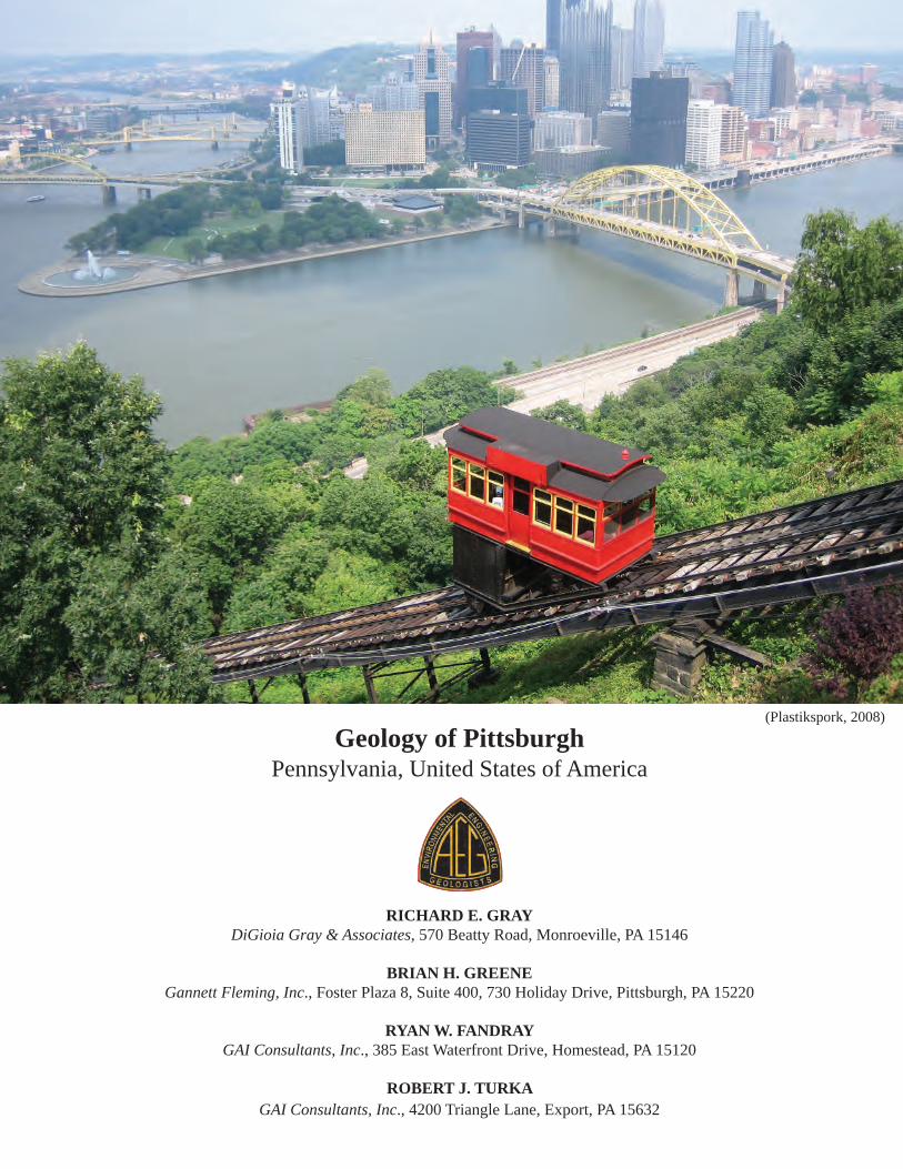
(Plastikspork, 2008)

2
Geology of Pittsburgh
Cities of the World
Geology of Pittsburgh, Pennsylvania, United States of AmericaPre-Published EditionPrinted and issued to registrants at the 58th Annual Meeting of the Association of Environmental & Engineering GeologistsPittsburgh, PA – September 19 through 26, 2015
Cover Plate. Duquesne Incline from Mount Washington (Plastikspork, 2008).

3
Gray, Greene, Fandray, and Turka
PREFACEOver the course of the last 35 years the AEG Cities of
The World Committee, under the leadership of Dr. Allen Hatheway, has sponsored peer-reviewed technical papers following a uniform format of discussion focusing on the environmental and geologic circumstances that brought people to settle in the 24 cities making up the series to date. In addition to the natural resources that brought original in-habitants to settle these regions, the series continues to bring forth the bevy of geologic conditions that have essential-ly controlled the development and expansion of each city. As we continue to move forward in the twenty-first cen-tury, during a time of environmental vigilance, geologists and engineers will meet and adapt to these same geologic conditions, in every instance to overcome the challenges of keeping each city capable of sustaining the presence of its always-expanding human population.
There is a ritual associated with the Editorship of the Cities Series, beyond seeking and processing each sub-mitted manuscript. The editorship offers this Preface as a spot-light on how the generally unique geologic regime of Pittsburgh and its surrounding area serves as a distinctly dif-ferent blend of the typical geologic features linking Earth’s history to today’s populated environments.
It is very apparent that the geologic conditions sur-rounding Pittsburgh have been the dominating influence that led to its founding, formed the basis of its industrial heritage, and continues to sculpt its modern landscape.
Pittsburgh lies in a geographic region known as the Ap-palachian Plateau, which has a long history of sedimenta-tion, followed by multiple cycles of tectonic construction, and punctuated by various later sequences of erosion and deposition associated with Pleistocene glaciation. This unique series of geologic events bestowed Western Penn-sylvania a river-and-ridge dominance and endowed it with plentiful natural resources.
French, British, and early American settlers quickly recognized the tract of land occupying the confluence of the Allegheny and Monongahela Rivers as a site of strategic im-portance for providing easy transportation and trade routes into the heartland of the continent. Pittsburgh came to be known as the Gateway to the West. Its economic advantage stems from its position on the northwestern edge of the rich Appalachian bituminous coal beds, and station at the eastern headwaters of the extensive Mississippi River system via the Ohio River Valley. Thus, humans came to regard Pitts-burgh as the best place to congregate west of Philadelphia and to set up shop for the rising horde of emigrants and oth-er adventurers setting out for the free-land bounties of the American West.
Harnessing the landscape to take advantage of these bountiful natural resources and passages west would become another matter, as western Pennsylvania would come to be the civil engineer’s proving ground. Every move made to set up commerce and industry was highly influenced by the space-and-place confined geologic constraints that derived directly from the river-and-ridge controls of more basic tectonic geologic structure. The really great temporal modifications to the overwhelming magnitude of valleys, ridges and rivers, have been brought about by the necessary engineered works that have been sought by the commercial and industrial activities within the valleys, and the neces-sities of arching transportation (canal, railroad, navigation improvement and flood control) that have become necessary to allow the population to earn their livings. The success or failure of every design for engineered works in and around the Pittsburgh area established, and has continued to prove the overwhelming significance of incorporating the “specification” of geologic conditions into engineered designs, the work product of the Engineering Geologist.
Joseph T. Krupansky, Series EditorGannett Fleming Inc., Valley Forge, [email protected]
Key Terms: Geology, Pittsburgh, Western Pennsylvania, Allegheny, Appalachian, Monongahela, Steel City, Fort Pitt, geohazards, slope stability, coal, Pennsylvanian, expansive shale, mine subsidence, acid mine drainage, confluence, canal, The Great Flood, ridge and valley, hydrofracturing, tunnel, fossil fuel, engineering geologist.
ABSTRACTThe City of Pittsburgh is located west of the Appala-
chian Mountains in a moderately to deeply dissected portion of the Appalachian Plateau Province. The relatively flat sur-face of the plateau is dissected by local drainage from the three principal rivers of the region, the Allegheny, Monon-gahela, and the Ohio. The formation of Pittsburgh’s three rivers has a long history dating back to before the Pleisto-cene Period, linked closely to the retreat of continental gla-ciation, and subsequent meltwaters filling the river channels and eroding the landscape. Pittsburgh was not glaciated; however, periglacial activity and sand-gravel outwash, rep-resent two major results of glaciation that terminated just north of Pittsburgh.
Western Pennsylvania is associated with the westernmost formation of the Appalachian Mountain chain. The Allegheny Orogeny had the most effect on Southwest Pennsylvania. The

4
Geology of Pittsburgh
uplift created a series of nearly flat-lying, gently warped Pa-leozoic sedimentary rocks under the region. Rocks outcrop-ping in the Appalachian Plateau vary in age from Devonian to Permian. Surficial bedrock of Southwest Pennsylvania is associated with deltaic depositional environments with a cy-clical nature, from fluctuating sea levels. Pennsylvanian stra-ta of the region are dominated by thin cyclic sequences of sandstone, shale, claystone, coal, and limestone.
Pittsburgh’s strategic location helped shape the west-ward expansion during the early formation of the Nation, largely because of the rivers, which served as an inexpen-sive, yet efficient means of transportation. The region was considered a stronghold for the emerging country because of its tactical location and later due to its abundance of nat-ural resources. Some of the natural resources include coal, natural gas, oil, salt, limestone, sand and gravel and water.
Geologic hazards present in Pittsburgh and its surround-ings include, mine subsidence, acid mine drainage, expansive shales and slags, pyritic acid rock and slope instability. Slope instability results from low shear strength colluvial deposits and the local Pittsburgh Redbeds, a notorious claystone re-sponsible for numerous landslides. Because of the region’s steep topography, abundant rainfall, low shear strength rocks, and soils with low residual strength, landslides have resulted in major property damage and loss of life.
Infrastructure is significant in Pittsburgh. The City began and grew because of the natural river systems, sup-plemented by manmade canals. Today, the region has 23 navigation locks and dams. The early system of canals was later replaced by rail systems for the shipment of bulk com-modities. Allegheny County, the county encompassing Pitts-burgh, has more bridges than any other county in the Nation. In addition to bridges, the City has eleven tunnels that fa-cilitate vehicular transportation and two locally famous in-clines, which were originally used to transport workers up and down the steep topographic feature known locally as Mt. Washington. However, the existing infrastructure of roads, bridges, tunnels, railways and navigation locks and dams are aging.
Today, Pittsburgh has transcended the legacy name, “Steel City.” Boasting a vibrant downtown, the City has na-tionally-recognized universities and medical centers. There is a resurgence in shale natural gas exploration using hydrof-racturing methods. Coal continues to be a dominant energy source for the numerous coal-fired power plants in the re-gion. Many environmental remediation projects are under-way in the region, related to acid mine drainage from legacy coal mining, reclaiming land areas of former steel mills, and past production sites of nuclear materials. Maintaining and replacing Pittsburgh’s aging infrastructure of roads, bridges, tunnels, dams and river navigation structures will be a major challenge and generate work for many years into the future.
INTRODUCTION
Geographic SettingAlthough Pittsburgh has a long history as a major in-
dustrial center, it occupies a relatively small area, 56 sq. miles, and has a population (US Census Bureau, 2010) of approximately 305,000. Pittsburgh is located within Allegh-eny County, which is one of the 67 counties in Pennsylva-nia. The Greater Pittsburgh Region is normally considered to include Allegheny County and the adjacent Armstrong, Beaver, Butler, Fayette, Washington and Westmoreland Counties. These counties comprise 5,343 square miles and have a population of more than 2.3 million people (US Cen-sus Bureau, 2010).
Pittsburgh is located to the west of the Appalachian Mountains in a moderately dissected portion of the Appa-lachian Plateau (Figure 1). Here the relatively flat plateau surface is deeply dissected by the drainage, which has pro-duced steep-sided valleys having a relief ranging up to 600 feet. The upland areas generally lie at an elevation greater than 1,200 feet above mean sea level and constitute only about ten to twenty percent of the surface area of the region. Valley slopes account for about fifty to seventy percent of the area, while the bottomlands constitute twenty percent or less (Gardner, 1980).
Figure 1. Appalachian Plateau-Western Pennsylvania (Modified from Gray et al., 1979).

5
Gray, Greene, Fandray, and Turka
Pittsburgh is located at the confluence of the three larg-est rivers in the region, the Allegheny, Monongahela, and the Ohio (Figure 1). The Allegheny River flows from the north, originating in northern Pennsylvania and southern New York. The Monongahela River flows from the south, originating in east central West Virginia. The Allegheny and Monongahela Rivers meet in Pittsburgh, and form the westward flowing Ohio. The Ohio River is a major artery of drainage into the interior of the continent, joining the Mis-sissippi River about 930 miles downstream from Pittsburgh at Cairo, Illinois (Gardner, 1980).
ClimateThe Pittsburgh area has four distinct seasons. Fall and
spring are generally warm and mild, summers are hot and humid with occasional heat waves and winters are cold and snowy. Based upon 30-year averages (NOAA, 2014), the mean monthly temperatures are warmest in July (72.6 °F) and coldest in January (28.4 °F). Pittsburgh averages 9.5 days per year when the temperature reaches 90 °F or higher and 5 days per year when the temperature drops below 0 °F. The highest temperature recorded in Pittsburgh, 103 °F, has occurred on three occasions (July 1881, August 1918 and July 1988), while the lowest recorded temperature, -22 °F, has occurred once in January 1994.
Average precipitation is 38.2 inches and is relatively evenly distributed through the year, with the driest month (October) averaging 2.29 inches of precipitation, and the wettest month (June) averaging 4.3 inches of precipitation. Records indicate that the largest one-day snowfall, 23.6 inches, fell on March 13, 1993, and that the largest one-day rainfall event, 5.95 inches, fell on September 17, 2004 (Hur-ricane Ivan). The second largest rainfall event, 3.6 inches, fell on September 8, 2004 (Hurricane Frances), only one week before the Hurricane Ivan rainfall.
History and FoundingThe first inhabitants of the Pittsburgh region were prob-
ably Paleo-Indians who may have occupied the area about 16,000 years ago, as indicated by archaeological findings at Meadowcroft Rock Shelter located on a small tributary to the Ohio River about 25 miles (40 km) southwest of Pittsburgh. The Paleo-Indians were hunter-gatherers who exploited the abundant animal and plant resources of the re-gion (Gardner, 1980).
The Paleo-Indian culture was followed by the Archaic hunter-gatherer culture, probably between 7,000 and 8,000 years ago, and the Archaic culture was supplanted by the Woodland culture about 3,000 years ago when agricul-ture was first introduced in the area. Two mound-building societies developed along the rivers and streams of this region during the Woodland cultural period. The first were the Adena mound-builders, who occupied the region from about 3,000 to 2,000 years ago before they were displaced
by the more advanced Hopewell culture that lasted from about 2,000 years ago to 500 A.D. (Gardner, 1980).
It was the strategic location at the confluence of the riv-ers that first attracted the attention of the European colo-nists to the “Forks of the Ohio” at what is now Pittsburgh. The conflicts between the British and French in Europe in the early and mid-1700s were transported to North America as both nations struggled for domination of the continent. The French claimed the area west of the Allegheny Moun-tains as theirs, including the combined Ohio and Allegheny Rivers; the English did not recognize these claims. A group of English colonials from Virginia formed an organization called the Ohio Land Company, whose members included Governor Dinwiddie of Virginia and Lawrence Washington, George Washington’s older brother. The Ohio Land Compa-ny claimed over half a million acres of the area around the Forks for trade and land speculation, land that the French had previously claimed as theirs. Ensuing clashes between the French and English trading in the area prompted Gov-ernor Dinwiddie to send a 21-year old major of the Virgin-ia Militia, George Washington, to deliver a protest to the French (Gardner, 1980).
Enroute, Major Washington travelled by the Forks and noted:
. . . I spent some time viewing the rivers, and the land in the Fork’ which I think extremely well situated for a fort, as it has absolute command of both rivers . . . the Land at the point is 20 to 25 feet above the common surface of the water; and a considerable bottom of flat, well-timbered land all around it, very convenient for building . . .
(from Washington’s Chronicle, in Lorant, 1975)
The confrontations with the French prompted the Virgin-ians to build a fort at the Forks as suggested by Washington. Construction of Fort Prince George was initiated in March 1754, and was the first recorded Euro-American construction on the land that is now Pittsburgh. The unfinished colonial fort was abandoned one month later when a superior force of
Figure 2. Pittsburgh’s Golden Triangle – 1776 (BrooklineConnection.com).

6
Geology of Pittsburgh
French and Indians threatened attack. The French then erect-ed their own fort, Fort Duquesne, at the Forks. The French controlled the Forks for four years, repelling several English attempts to regain control. In November of 1758, the French burned and abandoned Fort Duquesne in the face of immi-nent attack by British forces headed by General John Forbes and Colonel George Washington. The English erected their own fort on the ruins of Fort Duquesne, and Forbes named it Fort Pitt in honor of the then-current English Prime Minister, William Pitt. Fort Pitt received no attacks from the French, although it was besieged by Indians for two months during “Pontiac’s Conspiracy” in 1763. The end of the Indian up-rising reduced the need for Fort Pitt, and it was gradually dismantled in the mid-1760s (Gardner, 1980). Figure 2 shows Fort Pitt in 1776. A portion of Fort Pitt has been reconstructed in its original location at what is now Point State Park.
The community that developed around the Fort contin-ued to grow as a center of trade for the ever increasing travel from east to west, as Pittsburgh developed as a gateway to the west. Figure 3 shows the locations of Fort Duquesne, Fort Pitt and Pittsburgh in 1795. When the community was incorporat-ed as a city in 1816, it was the major center for commerce in the west, since most travel from the eastern seaboard to the west went through Pittsburgh. Henry Steele Commager, a noted historian, summarized the situation as follows:
. . . The historical significance of Pittsburgh was deter-mined from the beginning, by geography . . . . The city that was to rise at this strategic point on the threshold of the
Forks was at once the bridge from the East and the Gateway to the West, the most western of the great cities of the sea-board, the most eastern of the great cities of the valley: it is no accident that it has commanded that position now for a century and a half; its sovereignty unchallenged . . .
(Lorant, 1975)
Pittsburgh’s economy was primarily based on commerce in the late 1700s and early 1800s, thereby living up to its “Gateway” status. As Pittsburgh grew, it required an ever increasing supply of goods, most of which were manufac-tured in the east. However, transporting large quantities of trade goods and pioneer supplies was incredibly difficult and expensive because the rugged Appalachian Mountain ridges between Pittsburgh and lands to the east were a formidable barrier. For this reason, Pittsburgh was forced to develop its own manufacturing industry, and by 1815, it was producing significant quantities of iron, brass, tin and glass products. By 1830, the trade/commerce aspect of Pittsburgh’s economy was eclipsed by manufacturing. Thus, Pittsburgh was found-ed and began to flourish as a center of commerce and manu-facturing because of its geography. But Pittsburgh was only born of its geography; it owes most of its growth and eventual status as a leading industrial center to its geology (Gardner, 1980). In 1901, U.S. Steel Corporation was formed in Pitts-burgh, and by 1911, the city was the nation’s eighth largest, producing between a third and a half of the nation’s steel.
The most important factors affecting the growth of Pitts-burgh were the mineral resources of the region, including
Figure 3. Map of Pittsburgh – 1795 (Albert, 1896).

7
Gray, Greene, Fandray, and Turka
coal, oil, natural gas, some iron ore, and the availability of attendant requirements such as water, building materials, power, transportation capabilities, and marketability. How-ever, the single most important resource to affect Pittsburgh’s growth and industrial stature was coal (Gardner, 1980).
There are two significant coals, the Pittsburgh and Up-per Freeport seams that are mined in the Pittsburgh Region (Figure 11). They are two of at least thirteen coal seams that have been strip mined and/or deep mined at one place or another in the region.
The Pittsburgh Coal is considered to be one of the rich-est economic deposits in the world. The U.S. Geological Survey estimated that the Pittsburgh Coal alone yielded eight billion tons from the early 1900s to 1965, comprising thirty-five percent of all bituminous coal in the Appalachian Basin and twenty-one percent of the cumulative production for the entire United States. The Pittsburgh Coal is essen-tially “worked-out” and no longer deep-mined in Pittsburgh (Gardner, 1980) but it is still mined in the southwest corner of the state where the seam is much deeper.
The Upper Freeport Coal lies about 660 feet below the Pittsburgh Coal and has been deep-mined in a north-south belt east of the city and just north of the city. However, it is relatively thin and is not deep-mined under the city.
The first record of coal mining in Pittsburgh was made by Captain Thomas Hutchins in 1759 when he noted a coal mine on the hillside across the Monongahela River from Pittsburgh. The mine was developed in the coal outcrop by the British soldiers on “Coal Hill,” which is now called Mt. Washington. Coal was mined on a small scale until indus-trialization created a greater fuel demand by the mid-1800s.
The principal user of coal in the Pittsburgh region was the iron and steel industry. The iron industry began almost at the birth of the community. The first iron furnace reported in Pitts-burgh was built on Two Mile Run (Shadyside) in 1793, and closed after only one year of operation for lack of local timber for fuel and iron ore. Although Pittsburgh’s first iron furnace was unsuccessful, numerous furnaces operating in outlying ar-eas closer to the local ore deposits did succeed. Because Pitts-burgh was the center of commerce, trade, labor and marketing, the industry took advantage of these resources, and local iron forging became a lucrative business (Gardner, 1980).
REGIONAL GEOLOGY
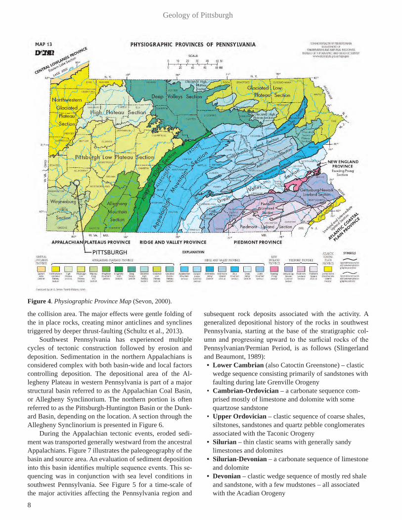
PhysiographyThe physiographic provinces of Pennsylvania are
sub-divided into regions that generally have a similar geo-logic structure, geomorphic history and climate. Pennsylva-nia is divided into six physiographic provinces according to the Pennsylvania Geologic Survey. Additionally, these six provinces are made up of smaller sections, which them-selves have unique characteristics. Figure 4 presents the Pennsylvania Physiographic Province Map provided by the
Pennsylvania Department of Conservation and Natural Re-sources (PA DCNR), (Sevon, 2000).
The Pittsburgh region is part of the upland area of the Appalachian Plateau Province. This upland area is a rela-tively flat surface with deeply dissected drainage that has produced steep-sided valleys with vertical relief on the or-der of 600 feet along the major drainages. The terrain is a dissected mature landscape developed on gently folded to essentially flat-lying sedimentary strata. In southwest Pennsylvania the structural geologic trends are northeast to southwest. The province is bounded to the southeast by the Valley and Ridge Province and to the northwest by the Cen-tral Lowlands Province.
The Appalachian Plateau Province in southwest Penn-sylvania is divided into the Pittsburgh Low Plateau Section, Waynesburg Hills Section and the Allegheny Mountain Sec-tion. The City of Pittsburgh is located in two of the sections, with the Pittsburgh Low Plateau Section to the north and the Waynesburg Hills Section to the south, as shown in Figure 4.
The Pittsburgh Low Plateau Section has a smooth to undulating surface composed of narrow and relatively shal-low valleys having a dendritic drainage pattern. It has low to moderate relief with the underlying rock composed most-ly of shale, siltstone, and sandstone. The geologic structure consists of moderate to low amplitude folds that decrease in occurrence in a northwestward direction.
The Waynesburg Hills Section is comprised of relative-ly hilly terrain with narrow hilltops and steep-sloped narrow valleys with a dendritic drainage pattern. It has moderate relief with underlying rock types of shale, sandstone, lime-stone, red shale and claystone. The geologic structure rang-es from low amplitude folds to horizontal bedding.
A small portion of the northwest section of the Appa-lachian Plateau was glaciated during the Pleistocene Epoch, with the closest approach of Wisconsinian ice about 30 miles north of the city. This was the last ice advance in the area.
Tectonic SettingThe tectonic history of western Pennsylvania is asso-
ciated with the westernmost formation of the Appalachian Mountain chain. Four different tectonic episodes produced the Appalachian Mountain chain. A geologic time scale of the major geologic events is shown in Figure 5.
The three earliest tectonic events are the Grenville Orogeny, Taconic Orogeny, and the Acadian Orogeny. These events had little effect on Pittsburgh and the south-west Pennsylvania area.
The fourth and final mountain building event, the Al-legheny Orogeny, did affect southwest Pennsylvania. This event began approximately 300 million years ago during the Pennsylvanian Period, and extended into the Permian Period (Hatcher, 2004). It resulted from the collision between the North American and African plates. Southwest Pennsylva-nia received much less deformation due to its distance from
8
Geology of Pittsburgh
the collision area. The major effects were gentle folding of the in place rocks, creating minor anticlines and synclines triggered by deeper thrust-faulting (Schultz et al., 2013).
Southwest Pennsylvania has experienced multiple cycles of tectonic construction followed by erosion and deposition. Sedimentation in the northern Appalachians is considered complex with both basin-wide and local factors controlling deposition. The depositional area of the Al-legheny Plateau in western Pennsylvania is part of a major structural basin referred to as the Appalachian Coal Basin, or Allegheny Synclinorium. The northern portion is often referred to as the Pittsburgh-Huntington Basin or the Dunk-ard Basin, depending on the location. A section through the Allegheny Synclinorium is presented in Figure 6.
During the Appalachian tectonic events, eroded sedi-ment was transported generally westward from the ancestral Appalachians. Figure 7 illustrates the paleogeography of the basin and source area. An evaluation of sediment deposition into this basin identifies multiple sequence events. This se-quencing was in conjunction with sea level conditions in southwest Pennsylvania. See Figure 5 for a time-scale of the major activities affecting the Pennsylvania region and
subsequent rock deposits associated with the activity. A generalized depositional history of the rocks in southwest Pennsylvania, starting at the base of the stratigraphic col-umn and progressing upward to the surficial rocks of the Pennsylvanian/Permian Period, is as follows (Slingerland and Beaumont, 1989):• Lower Cambrian (also Catoctin Greenstone) – clastic
wedge sequence consisting primarily of sandstones with faulting during late Grenville Orogeny
• Cambrian-Ordovician – a carbonate sequence com-prised mostly of limestone and dolomite with some quartzose sandstone
• Upper Ordovician – clastic sequence of coarse shales, siltstones, sandstones and quartz pebble conglomerates associated with the Taconic Orogeny
• Silurian – thin clastic seams with generally sandy limestones and dolomites
• Silurian-Devonian – a carbonate sequence of limestone and dolomite
• Devonian – clastic wedge sequence of mostly red shale and sandstone, with a few mudstones – all associated with the Acadian Orogeny
Figure 4. Physiographic Province Map (Sevon, 2000).

9
Gray, Greene, Fandray, and Turka
• Mississippian – clastic wedge mainly comprised of sandstone and shale with a few conglomerates
• Pennsylvanian into the Permian – dominates exposures in southwest Pennsylvania – clastic sequence consisting of sandstone, shale, mudstone and coal from Allegheny Orogeny with multiple delta complexes
The surficial bedrock of southwest Pennsylvania shows characteristics associated with deltaic depositional envi-ronments with a cyclical nature indicating a fluctuating sea level. Figure 8 illustrates a generalized lithologic column for southwest Pennsylvania along with the types of deposi-tional environments associated with some of the rock units.
Geologic SettingRock strata outcropping in the Appalachian Plateau
vary in age from Devonian to Permian as shown in Figure 9, the Geologic Map of Pennsylvania. Devonian age rocks outcrop north of Pittsburgh. Mississippian age strata also outcrop north of Pittsburgh, as well as on the ridges east of Pittsburgh. Rocks of Pennsylvanian age form the surface strata within the Pittsburgh area. Permian age rock outcrops southwest of Pittsburgh.
The structural trend of the Appalachian Plateau ranges from North 30° East to North 70° East (Amdt et al., 1969). The lengths of the anticlines and synclines vary significantly, as shown in Figure 10. The dip associated with these folded structures is generally no more than a few degrees. Pennsylva-
nian strata are characterized by thin cyclic sequences of sand-stone, shale, claystone, coal, and limestone (Philbrick, 1953, 1959, 1960). The most readily identifiable and consistent rock strata are the coal beds and some limestone beds.
Faulting is not common, but some minor localized vertical displacements are present.
Stratigraphy
Sedimentary RockThe surface and near-surface rock in the greater Pitts-
burgh area belong to the Permian and Pennsylvanian age Dunkard Group and the Pennsylvanian age Monongahela, Conemaugh and Allegheny Groups. A generalized strati-graphic column of the Pittsburgh region is presented in Figure 11. Locations of counties are identified on the Geolog-ic Map of Pennsylvania in Figure 9. A generalized summary of these rock types follows:
Dunkard Group / Permian and PennsylvanianThis group occurs near the surface in central and south-
ern Washington County, which is southwest of the City of Pittsburgh (See Figure 9). The Dunkard reaches a maxi-mum thickness of about 1120 feet (Berryhill et al., 1971) in Greene County and the upper surface is the modern day erosional surface. It is generally composed of fine-grained clastics which are frequently calcareous. The lower bound-ary of the Dunkard Group is defined as the base of the
Figure 5. Geologic Time Scale of Major Geologic Events in Pennsylvania (Barnes and Sevon, 2002).

10
Geology of Pittsburgh
Waynesburg Coal, which is the only coal routinely mined in the Dunkard. It is made up of the Waynesburg, Washington and Greene Formations (Berryhill et al., 1971). The basal Waynesburg Formation consists of shale, sandstone, silt-stone, and coal. The overlying Washington Formation out-crops in valley bottoms in the northwest corner of Greene County and consists of limestone, claystone, siltstone, sandstone, carbonaceous shale, and coal. Thick lacustrine limestones are especially prevalent in the Washington For-mation. The uppermost Greene Formation, which covers the western half of Greene County and caps the tops of
ridges in the eastern part of the county, consists mostly of shale, sandstone, siltstone, and limestone.
Monongahela Group / PennsylvanianThe Monongahela Group underlies the Waynesburg
Group, extending from the base of the Waynesburg Coal to the base of the Pittsburgh Coal, as shown in Figure 11. The Group includes the Uniontown and Pittsburgh Formations. It is a non-marine sedimentary sequence. Coal seams, includ-ing the Uniontown, Sewickley, Redstone and the Pittsburgh Coals, are persistent and are the primary marker beds in the area. This group ranges in thickness between 275 and 290 feet (Berryhill et al., 1971). It consists of cyclic sedimentary sequences formed in a relatively low energy, marginal upper delta plain having extensive lake and swamp development (Berryhill et al., 1971; Donaldson, 1974). The depositional environments of the coals are identified as tropical swamps in anaerobic conditions.
The Uniontown Formation contains both an upper and lower member separated by the Little Waynesburg Coal. The Upper Member is shale or very thinly bedded sandstone. The Lower Member is mostly sandstone with interbedded coal lenses near its base.
The Pittsburgh Formation contains several coal seams, including the laterally extensive Pittsburgh Coal, which is the basal member of the Pittsburgh Formation. The Pittsburgh Formation is divided into five members: the lower member; Redstone; Fishpot; Sewickley; and the upper member. This formation consists of numerous relatively persistent limestone seams and lesser claystone beds in the upper portion with the lower portion predominately shale, sandstone and coal seams.
The lower member includes the approximately 10-foot thick, persistent Pittsburgh Coal, overlain by the only clastic rock within the Pittsburgh Formation, the Pittsburgh Sand-stone. The Pittsburgh Sandstone is a persistent fluvial unit that is generally thinly bedded to massive. A major fluvial channel system, flowing north to northwest through what is now Greene and Washington Counties, deposited this unit as an elongated sandstone body up to 80 feet thick and sev-eral miles wide (Edmunds et al., 1999).
The Redstone Member is stratigraphically above the lower member and is characterized by siltstone and clay-stone and includes a persistent limestone unit. The division between the lower member and the Redstone Member is
Figure 7. Inferred Paleogeography of Pennsylvania during the Late Pennsylvanian when the rocks of Pittsburgh were being deposited (Wagner et. al., 1970).
Figure 8. Generalized Lithology Column of Southwestern Pennsylvania (Pryor and Sable, 1974).
Figure 6. Cross-section of the Geologic Structure of the Allegheny Plateau (King, 1977).

11
Gray, Greene, Fandray, and Turka
typically marked by the Redstone Coal; however, the coal is laterally discontinuous.
The Fishpot Member, the next stratigraphic unit within the Pittsburgh Formation, is the thinnest unit. The Fishpot includes mainly siltstone and claystone with several thin sandstone bod-ies. This formation can be difficult to identify where the Fish-pot Coal is absent because it marks the base of the Fishpot.
The Sewickley Member represents the thickest lime-stone sequence, the Benwood Limestone. The Benwood Limestone is a relatively thick interbedded limestone and shale unit that is dolomitic in portions of the region.
The thick upper member of the Pittsburgh Formation contains four limestone units designated in ascending order as “A”, “B”, “C”, and “D”. These rather persistent limestone seams are interbedded with siltstone and shale seams that are generally in proportion with the thickness of the lime-stone found above these fine-grained seams. Limestones of the Monongahela Group are freshwater limestones, deposit-ed during highstands in the lakes of alluvial plains.
Conemaugh Group / PennsylvanianThe Conemaugh Group underlies the Monongahela Group
in southwest Pennsylvania. This sedimentary group includes the Glenshaw and Casselman Formations, and is a clastic se-quence dominated by siltstone, claystone, shale and sandstone. The average thickness of this group is approximately 620 feet (Schultz, 1999), and extends from the base of the Pittsburgh Coal to the top of the Upper Freeport Coal. Bedrock exposure of the Conemaugh Group is limited in southwest Pennsylva-nia, with most exposures at and north of Pittsburgh.
The Conemaugh stratigraphy is subdivided into two dis-tinct formations (Flint, 1965) based upon marine units, with the boundary between them being the top of the persistent Ames limestone. The upper unit, the Casselman Formation, is essen-tially devoid of marine units, while the lower unit, the Glen-shaw Formation, contains widespread marine units (Schultz, 1999). Mineable coals are not common in the Conemaugh.
The Casselman Formation extends from the base of the Pittsburgh coal to the base of the Ames Limestone and con-
Figure 9. Geologic Map of Pennsylvania (Pennsylvania Bureau of Topographic and Geologic Survey, 2007).

12
Geology of Pittsburgh
sists of a sequence of alternating layers of sandstone, shale, red beds (claystone), limestone and thin discontinuous coal seams. The Ames Limestone is a laterally continuous fos-siliferous limestone that is generally on the order of two to four feet thick. It serves as the primary marker bed in the Conemaugh Group, and identifies the youngest marine transgression in southwest Pennsylvania.
The Birmingham Shale is a significant unit within the Casselman Formation. It is generally described as a dark, thinly laminated rock nearly 50 feet thick that occurs below the Morgantown sandstone, and about 30 to 60 feet above the Ames Limestone in Pittsburgh. It consists mainly of fine-grained siltstone and shale overbank deposits. Marine fossils have been found in the shale outcrops at Birmingham Station (just west of Pittsburgh). This transition zone con-tains marine to brackish fauna and represents the last marine episode of the Paleozoic in Pennsylvania.
The Glenshaw Formation extends from the base of the Ames Limestone to the top of the Upper Freeport Coal. The claystones and shales are the weaker units. These weaker members are notorious for landslide potential. All of these rock units are commonly interbedded and tend to change lithologically over short lateral distances.
A primary source in southwest Pennsylvania for land-slides is the Pittsburgh Red Beds, which is near the top of the Glenshaw Formation. It is a 40 to 60 foot series of mostly reddish, greenish, and grayish claystone and shale, with mi-nor amounts of sandstone and siltstone that tend to weather deeply on hillsides throughout southwestern Pennsylvania. Claystone is a low permeability, low strength rock with weakly connected pore space. Repeated weathering cycles and excessive pore pressure have a tendency to reduce the in-ternal shear strength of this particular rock, which can lead to failure. In addition, Conemaugh claystones contain minerals that tend to expand in the presence of water (Pomeroy, 1982).
These red shales have been interpreted as a paleosol horizon (ancient soil zone) on the Pennsylvanian delta by Donahue and Rollins (1974). They suggest that the red col-or and the claystone texture are similar to that of a laterite soil weathering profile. Good exposures of the series can display evidence of an ancient soil development with some occasional root casts and calcite-rich nodules.
Allegheny Group / PennsylvanianThe Allegheny Group underlies the Conemaugh with a
thickness between 270 and 330 feet in western Pennsylvania (Edmunds et al., 1999) beginning at the top of the Upper Free-port Coal and extending to the base of the Brookville Coal. This group consists largely of marine units and contains six mineable coals, referred to as the Upper Freeport Coal, Low-er Freeport Coal, Upper Kittanning Coal, Middle Kittanning Coal, Lower Kittanning Coal and the Brookville Coal. These coals outcrop north of the Pittsburgh area. Coals and associ-ated strata of the lower Allegheny Group (Brookville through
Figure 10. Generalized locations of Structural Axes in Allegheny County (Wagner et. al., 1970).
Figure 11. A Generalized Stratigraphic Column of the Pittsburgh Region (Harper, 1990).

13
Gray, Greene, Fandray, and Turka
Middle Kittanning coals) were deposited during a general eastward marine transgression. The setting was a shifting complex of marine to brackish embayments, lower-delta-plain distributaries, and interdistributary to coastal margin swamps, grading inland to an upper-delta-plain fluvial and interfluvial swamp system (Williams, 1960; Williams and Ferm, 1965; Ferm and Cavaroc, 1969; Ferm, 1970, 1974). The upper Al-legheny Group (Upper Kittanning through Upper Freeport coals) was deposited in a relatively high energy, upper-del-ta-plain fluvial and interfluvial lake and swamp environment during a period of general marine regression (Sholes et al., 1979; Skema et al., 1982).
The Allegheny Group contains a repeating succession of coal, limestone, and clastics, ranging from claystone to coarse sandstone. Most beds exhibit lithologic change both vertical-ly and laterally over short distances, but some coals, a few marine shales and limestones are continuous over large areas.
Pottsville Group / PennsylvanianThe Pennsylvanian age Pottsville Formation is a major
ridge-former in the Ridge-and-Valley Province of the east-
ern United States and along the Allegheny Front, the east- facing escarpment of the Appalachian Plateau. The Formation ranges in thickness from 100 feet to 1,600 feet (Edmunds, 1999). The Pottsville Formation consists predominately of a well-cemented cobble and pebble conglomerate with some sandstones and finer clastics and coal (Edmunds, 1999) that range in thickness from about 10 to 70 feet. It extends upward from the top of the Mississippian Mauch Chunk Formation to the base of the underclay beneath the Brookville coal of the Allegheny Formation. Abrupt variations in the thickness of the Pottsville of up to 100 feet have been observed in short distances, with this variability mainly occurring in the basal part of the formation (McElroy, 2000). The formation has mi-nor marine limestones in northern Pennsylvania. Mining of coal in the Pottsville is limited. Because it contains resistant rock units, it tends to form ridges and cap most of the high-points, including Mount Davis (3,213 feet), the highest point in Pennsylvania, which is located in Somerset County.
Igneous and Metamorphic RocksPrecambrian basement rock (See Figure 12) underlies all
of Pennsylvania, but is only exposed in the southeastern part of the state. A thick Paleozoic sequence overlies the basement for all of southwest Pennsylvania. The depth of the basement rocks directly under the Pittsburgh region is inferred from deep wells located in northwestern Pennsylvania, eastern Ohio and northwestern West Virginia.
The basement in the Pittsburgh region is at a depth rang-ing from 14,700 to 16,400 feet according to the Geology of Pennsylvania (Saylor, 1999), and is believed to have lithol-ogies similar to the Canadian Grenville belt. The most com-mon lithologies identified are granite, gneiss, biotite granite and biotite schist (Saylor, 1999), and all of these lithologies have been metamorphosed to the greenschist or amphibole facies (Bass 1959, 1960; Saylor, 1968).
Some indirect evidence has been found that deformation of the basement exists; however, little physical information is available. Investigation and research into the basement is prohibited by the depth to this horizon, and most remote sensing data remains confidential for the increasing gas exploration from the recent Middle Devonian shale gas boom. There are no surface metamorphic rocks in western Pennsylvania.
The only near surface igneous rock in western Penn-sylvania are two Jurassic kimberlite dikes. The first is the Gates-Adah Dikes, which outcrop near the Monongahela River on the border of Fayette and Greene Counties (south of Pittsburgh), shown in Figure 9. The Gates-Adah kim-berlite intruded approximately 170 million years ago (Bik-erman et al., 1997), appears to have formed at a relatively shallow depth and contains mostly pyrope garnets and Alex-andrite-effect pyropes.
The other kimberlite intrusion is the Dixonville-Tanoma Dikes in central Indiana County (northeast of Pittsburgh) as
Figure 12. Subsurface Rocks below Western Pennsylvania (Adapted from Flaherty and Flaherty, 2014; and Wagner et al., 1970).

14
Geology of Pittsburgh
shown in Figure 9. These dikes are not exposed on the sur-face, but were discovered in the Tanoma Coal Mine while mining the Upper Freeport Coal. One of the dikes is about 15 inches wide and extends thousands of feet laterally. The coal mine has closed and the dike is no longer accessible.
Surficial Geologic and Soil FeaturesExisting and past climatic conditions have resulted in
substantial mechanical and chemical weathering, which produced a residual or colluvial soil mantle over the rocks of the Pittsburgh region. The sedimentary rock strata are normally not exposed, other than in valley walls and exca-vations into rock. There is considerable evidence that rocks of this region remain highly stressed, and subsequent stress relief due to valley cutting aids in the physical breakup of rock and enhances its susceptibility to chemical weathering (Ferguson, 1967, 1974; Voight, 1974). The most important discontinuities within the surficial rock are joints. Both tec-tonic and stress-relief jointing are recognized. Both system-atic and non-systematic jointing occurs, with the majority of non-systematic joints in the weaker, fine-grained rock.
Joints caused by the local release of residual stress are closely spaced (up to 10 feet) whereas joints caused by tec-tonic stresses exhibit a spacing of many feet (Nickelsen and Hough, 1967). The finer-grained rocks have more closely spaced joints. Nickelsen and Hough (1967) present details
of joint patterns, trends and spacing in the Appalachian Pla-teau of Pennsylvania.
Southwestern Pennsylvania is dominated by soil de-rived from acidic shales and sandstones consisting of clay-sized particles with moderate to substantial amounts of rock fragments. The surficial soils are predominantly silty loams, which are usually well-drained. This region has relatively steep slopes, making erosion a major concern. The available water-holding capacity (i.e. porosity) of many soils in the re-gion is relatively moderate. Residual soils are characteristic of the flat upland surfaces and flat surfaces of larger benches, with colluvial soils forming the slopes. In general, the thick-ness of residual or colluvial soils in the Pittsburgh region is on the order of 10 to 30 feet. Alluvial soils fill stream and river valleys and reach thicknesses of up to 100 feet.
Pleistocene GlaciationPittsburgh has never been glaciated. However, perigla-
cial activity and sand and gravel outwash are two major re-sults of glaciation that occurred north of Pittsburgh. Figure 13 shows the limit of glaciation in Western Pennsylvania and the present river systems. Extensive periglacial activity south of the glacial limits, consisting of cold wet weather and frequent freeze-thaw cycles, impacted the Pittsburgh area. This severe climate caused extensive mass wasting through rock breakup and downslope movement of broken material. Peltier (1950) and Denny (1956) found fossil periglacial features close to the front of the maximum advance of Wisconsinian glacia-tions in Pennsylvania which strongly supports Pleistocene periglacial processes influencing development of slopes.
Radiocarbon dating of wood from several large colluvi-al slide masses in western Pennsylvania and West Virginia indicate a Pleistocene age, and thus a periglacial origin, for these deposits (Gray et al., 1979).
Wisconsinian glaciation significantly altered the cours-es of the Allegheny and Ohio Rivers, and glacial outwash filled the valleys with sand and gravel. Erosion subsequent-ly removed approximately 80 feet of the sand and gravel, leaving about 50 feet of alluvium which created a significant aquifer in the river valleys. The alluvium consists of hard, dense sand and gravel which provides excellent foundation conditions for large buildings and heavy structures along with a high quality source of durable sand and gravel.
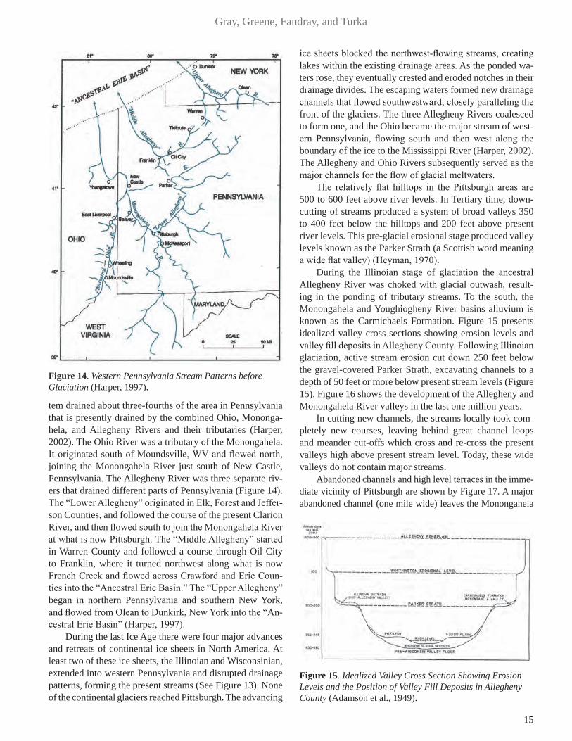
Pittsburgh’s Three RiversPrior to the Pleistocene glaciation, which began approx-
imately 800,000 to 1,000,000 years ago, the Monongahela River was the dominant river in southwestern Pennsylvania (Figure 14). It flowed north to the site of Pittsburgh in a channel approximately coincident with its present channel. From Pittsburgh, it followed the channel of the present Ohio River to Beaver, PA where it turned north up the present Beaver River Valley and flowed north into the “Ancestral Erie Basin” (Harper, 1997). This Monongahela River sys-
Figure 13. Limit of Glaciation in Western Pennsylvania and Present River Systems (Harper, 1997).
15
Gray, Greene, Fandray, and Turka
tem drained about three-fourths of the area in Pennsylvania that is presently drained by the combined Ohio, Mononga-hela, and Allegheny Rivers and their tributaries (Harper, 2002). The Ohio River was a tributary of the Monongahela. It originated south of Moundsville, WV and flowed north, joining the Monongahela River just south of New Castle, Pennsylvania. The Allegheny River was three separate riv-ers that drained different parts of Pennsylvania (Figure 14). The “Lower Allegheny” originated in Elk, Forest and Jeffer-son Counties, and followed the course of the present Clarion River, and then flowed south to join the Monongahela River at what is now Pittsburgh. The “Middle Allegheny” started in Warren County and followed a course through Oil City to Franklin, where it turned northwest along what is now French Creek and flowed across Crawford and Erie Coun-ties into the “Ancestral Erie Basin.” The “Upper Allegheny” began in northern Pennsylvania and southern New York, and flowed from Olean to Dunkirk, New York into the “An-cestral Erie Basin” (Harper, 1997).
During the last Ice Age there were four major advances and retreats of continental ice sheets in North America. At least two of these ice sheets, the Illinoian and Wisconsinian, extended into western Pennsylvania and disrupted drainage patterns, forming the present streams (See Figure 13). None of the continental glaciers reached Pittsburgh. The advancing
ice sheets blocked the northwest-flowing streams, creating lakes within the existing drainage areas. As the ponded wa-ters rose, they eventually crested and eroded notches in their drainage divides. The escaping waters formed new drainage channels that flowed southwestward, closely paralleling the front of the glaciers. The three Allegheny Rivers coalesced to form one, and the Ohio became the major stream of west-ern Pennsylvania, flowing south and then west along the boundary of the ice to the Mississippi River (Harper, 2002). The Allegheny and Ohio Rivers subsequently served as the major channels for the flow of glacial meltwaters.
The relatively flat hilltops in the Pittsburgh areas are 500 to 600 feet above river levels. In Tertiary time, down-cutting of streams produced a system of broad valleys 350 to 400 feet below the hilltops and 200 feet above present river levels. This pre-glacial erosional stage produced valley levels known as the Parker Strath (a Scottish word meaning a wide flat valley) (Heyman, 1970).
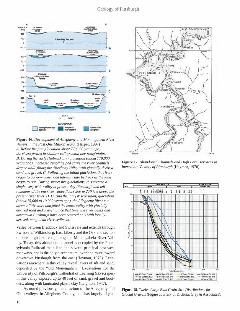
During the Illinoian stage of glaciation the ancestral Allegheny River was choked with glacial outwash, result-ing in the ponding of tributary streams. To the south, the Monongahela and Youghiogheny River basins alluvium is known as the Carmichaels Formation. Figure 15 presents idealized valley cross sections showing erosion levels and valley fill deposits in Allegheny County. Following Illinoian glaciation, active stream erosion cut down 250 feet below the gravel-covered Parker Strath, excavating channels to a depth of 50 feet or more below present stream levels (Figure 15). Figure 16 shows the development of the Allegheny and Monongahela River valleys in the last one million years.
In cutting new channels, the streams locally took com-pletely new courses, leaving behind great channel loops and meander cut-offs which cross and re-cross the present valleys high above present stream level. Today, these wide valleys do not contain major streams.
Abandoned channels and high level terraces in the imme-diate vicinity of Pittsburgh are shown by Figure 17. A major abandoned channel (one mile wide) leaves the Monongahela
Figure 14. Western Pennsylvania Stream Patterns before Glaciation (Harper, 1997).
Figure 15. Idealized Valley Cross Section Showing Erosion Levels and the Position of Valley Fill Deposits in Allegheny County (Adamson et al., 1949).
16
Geology of Pittsburgh
Valley between Braddock and Swissvale and extends through Swissvale, Wilkinsburg, East Liberty and the Oakland section of Pittsburgh before rejoining the Monongahela River Val-ley. Today, this abandoned channel is occupied by the Penn-sylvania Railroad main line and several principal east-west roadways, and is the only direct natural overland route toward downtown Pittsburgh from the east (Heyman, 1970). Exca-vations anywhere in this valley reveal layers of silt and sand, deposited by the “Old Monongahela.” Excavations for the University of Pittsburgh’s Cathedral of Learning (skyscraper) in this valley exposed up to 40 feet of sand, gravel and boul-ders, along with laminated plastic clay (Leighton, 1947).
As noted previously, the alluvium of the Allegheny and Ohio valleys, in Allegheny County, consists largely of gla-
Figure 16. Development of Allegheny and Monongahela River Valleys in the Past One Million Years. (Harper, 1997) A. Before the first glaciation about 770,000 years ago, the rivers flowed in shallow valleys amid low-relief plains. B. During the early (Nebraskan?) glaciation (about 770,000 years ago), increased runoff helped carve the river channels deeper while filling the Allegheny Valley with glacially-derived sand and gravel. C. Following the initial glaciation, the rivers began to cut downward and laterally into bedrock as the land began to rise. During successive glaciations, this created a single, very wide valley at present-day Pittsburgh and left remnants of the old river valley floors 200 to 250 feet above the present river level. D. During the late (Wisconsinan) glaciation (about 75,000 to 10,000 years ago), the Allegheny River cut down a little more and filled the entire valley with glacially derived sand and gravel. Since that time, the river banks and downtown Pittsburgh have been covered only with locally- derived, nonglacial river sediment.
Figure 17. Abandoned Channels and High Level Terraces in Immediate Vicinity of Pittsburgh (Heyman, 1970).
Figure 18. Twelve Large Bulk Grain-Size Distributions for Glacial Gravels (Figure courtesy of DiGioia, Gray & Associates).

17
Gray, Greene, Fandray, and Turka
cial outwash gravel and sand and is the primary source of groundwater in Allegheny County. Pebbles of crystalline rock transported from considerable distances north of the area are found included with pebbles of resistant sandstone of local origin in these valley deposits. The finer material is likewise of both remote and local origin. Most of the com-mercial gravel deposits in the vicinity of Pittsburgh will pass a 2-inch screen, but boulders are not uncommon. The material is well sorted in some places, but more common-ly the grain size varies considerably. Figure 18 presents 12 large bulk grain size distribution curves for the glacial grav-els from a deep excavation on the North side of the Ohio River in Pittsburgh. On average, gravel constitutes over 60 percent (by weight) of the glacial outwash.
The average maximum thickness of the valley alluvium is about 60 feet. Normally, glacial sand and gravel consti-tutes the basal part of the alluvium and is overlain by recent flood plain deposits ranging in thickness from 0 to 25 feet. In parts of the present stream bed, the topmost member of the alluvium is a layer of very fine silt which, to some extent, is transitory and is probably scoured during floods and rede-posited as high water stages decline. Characteristic sections across the Allegheny and Ohio Valleys are shown in Figure 19. Laterally, these alluvial deposits extend the width of the pre-Wisconsinian stream valleys, which are wider than the present streams. Generally, the bedrock floor of the valleys is relatively flat, except in a few areas in the upper Ohio River where shallow channels were cut into the bedrock floor before the valley aggraded. In Allegheny County, the thickness of water-bearing sand and gravel remains fairly constant across the valleys; however, the sediments thin rapidly near the val-ley walls (Adamson et al., 1949). Figure 20 shows contours of the rock surface below Pittsburgh’s downtown area, and the approximate eastern limit of water bearing glacial gravel.
The old valley bedrock floor on the Allegheny River, which declines from elevation 682 feet above sea level at Tarentum to 661.5 feet immediately above the junction of the Allegheny and Monongahela Rivers (Pittsburgh’s Point), averages a gradient of 1 foot per mile. Continuing down the Ohio 13 miles from the Point, the ancient valley floor is found at an elevation of 651 feet, and the average gradient is 0.8 feet per mile over this distance. At no place in the Allegheny and Ohio Valleys in the county has bedrock been recorded at a depth in excess of 85 feet below the av-erage river level.
Within Allegheny County the maximum thickness of the Monongahela Valley alluvium is 65 feet. The pre-Wis-consinian age Monongahela Valley Floor has a gradient of about 0.8 feet per mile from Elizabeth, PA to the Point which is a distance of about 23 miles (Adamson et al., 1949).
NATURAL RESOURCES
Salt, Oil and Natural GasSalt was an early high value mineral and was much
sought after on the frontier. It was expensive to haul over the mountains from the east coast and therefore local sources were sought and established. It was originally obtained by evaporating naturally occurring saline brine discharges in springs in the area. The process was simple, settlers would dig holes and the holes would fill with brine which was col-lected and kettle-evaporated to obtain the crystalline salt residue. Later wells were drilled for salt, which frequently tapped the sandstones in the Pottsville Group which became known as “salt sands.”
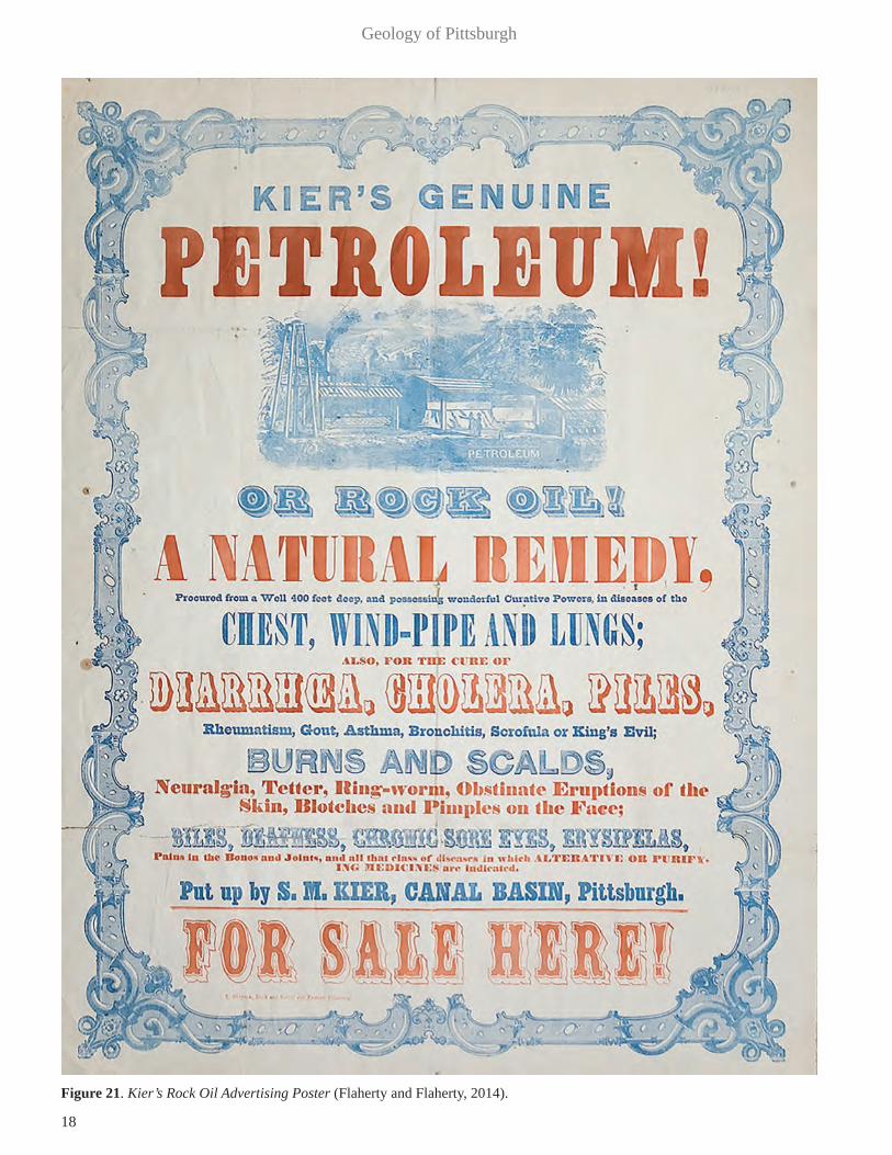
Crude oil was occasionally found in conjunction with the brine in the salt wells and was originally considered a nui-sance to be discarded. Samuel Kier (ExplorePAhistory.com,
Figure 19. Sections across Allegheny and Ohio River valleys (Adamson et al., 1949).
Figure 20. Contours of the Rock Surface Below Downtown Pittsburgh and the Eastern Limit of Water-Bearing Glacial Gravel (Van Tuyl, 1951).
18
Geology of Pittsburgh
Figure 21. Kier’s Rock Oil Advertising Poster (Flaherty and Flaherty, 2014).

19
Gray, Greene, Fandray, and Turka
Kier Refinery), an American inventor and business man, op-erated salt wells on his family property located in Tarentum, to the northeast of Pittsburgh. He noticed that the crude oil in the salt wells was similar to what was being prescribed for homeopathic cures for various illnesses, and began collecting and bottling the oil and selling it as a “cure-all.” In 1849, he opened a bottling and merchandising house in Pittsburgh, and his “Kiers Rock Oil” sold throughout the northeastern United States (See Poster, Figure 21). The oil was sold at the pricey rate of 50 cents (a day’s wages) for a half pint bottle and the label read, “Kiers petroleum or rock oil. Celebrated for its wonderful curative powers. A natural remedy. Procured from a well in Allegheny (County), Pa. four hundred feet below the earth’s surface.” (Richardson, 1932). He also began to experiment with the crude oil as an illuminant and sold the “carbon” oil from a warehouse in Pittsburgh. In order to cap-italize on his discovery, he built the first commercial petro-leum refinery in Pittsburgh in 1854 to produce illuminating oil from the crude oil he obtained from the family salt wells. Kier was forced to move his refinery operation out of the city because of local residents’ fear of fire and explosions.
Once it was determined that the “rock” oil had a use, it was collected from the salt wells and from crude oil seeps. In those areas pits were dug to collect the oil which was removed and containerized for subsequent sale. Commer-
cial oil production began in Pennsylvania with the drilling of the Drake discovery well in 1859 (See Figure 22). The well was drilled near Titusville, Venango County, Pennsyl-vania, which is located about 100 miles north of Pittsburgh, and was the nation’s first economically-viable well drilled intentionally to produce commercially valuable crude oil (Carter and Flaherty, 2011). Oil exploration slowly moved south, and in 1886, the Mt. Nebo Field was discovered in nearby Ohio Township, Allegheny County. The slow south-ward movement of oil recovery activity was due primarily to the increasing depths of the oil bearing Venango sandstones. The Drake well was drilled in an area of known oil seeps, and had a final depth of about 69 feet. Oil-bearing Venango sandstones in that area were no more than 100 feet deep. The Venango sandstones in the Pittsburgh area are at depths of between 1,200 feet and 2,800 feet. Such depths required the development of new exploratory and developmental drilling equipment and techniques. Between 1886 and 1904, almost all of the shallow oil fields in Allegheny County had been found and exploited and the local oil industry started to de-cline. Pittsburgh profited by more than just the oil from the wells because it was the largest industrialized city near the new oil fields. By the 1870s, there were more than fifty oil refineries operating in the area with a total production of more than 35,000 barrels of oil per day (Gardner, 1980).
Figure 22. Replica of Drake Well, Titusville, PA (Flaherty and Flaherty, 2014).

20
Geology of Pittsburgh
The nation’s first commercial gas well, the Haymaker well in Murrysville, PA, about 20 miles east of Pittsburgh, was drilled in 1878. Gas from that well was piped into Pitts-burgh in 1883, which was at the technical limit of such pipe-lines for that time.
Figure 23 shows the general area/extent of traditional oil and gas, and shale gas reservoirs in Pennsylvania. Lim-
ited amounts of gas and oil from these “shallow” Missis-sippian and Devonian sandstones are still produced in the area from some of the early wells. A number of the depleted gas and oil fields in the area are now utilized as gas storage fields by some of the regional gas companies.
In recent years the industry has seen a rebirth with the development of natural gas from deeper sources. The source currently being developed is the Middle Devonian Marcellus Shale, which is at a depth of around 6,000 feet in the Pittsburgh area. Much news attention is given to the Marcellus Shale, as it is thought to contain about 50 trillion cubic feet of natural gas and is recovered using fracking techniques, which are being widely debated in regard to possible environmental impacts associated with development. Another recently identified natu-ral gas source in the area is the Upper Ordovician Utica Shale, which underlies the Marcellus Shale and has a corresponding-ly larger lateral extent. The Utica in the Pittsburgh area lies at a depth of about 10,000 feet to 12,000 feet. It is estimated to contain about 38 trillion cubic feet of yet-undiscovered, techni-cally recoverable natural gas (at the mean estimate) according to the first assessment of this continuous (unconventional) nat-ural gas accumulation by the U. S. Geological Survey (Schenk et al., 2012). The Utica Shale has a corresponding mean esti-
Figure 23. Oil and Gas Reservoirs in Pennsylvania (Flaherty and Flaherty, 2014).
Figure 24. Distribution of Pennsylvania Coals (Commonwealth of Pennsylvania, 2008).
21
Gray, Greene, Fandray, and Turka
mate of 940 million barrels of unconventional oil resources and a mean estimate of 208 million barrels of unconventional natural gas liquids.
CoalPennsylvania is located at the northern end of the Appa-
lachian Coal Basin. Coal beds underlie about 15,000 square miles of the State (See Figure 24). All significant coal beds in Pennsylvania are of Pennsylvanian or Permian age. Prior to any mining, Pennsylvania contained over 75 billion tons of bituminous coal and almost 23 billion tons of anthracite and semianthracite coal (Edmunds, 1999a).
Early Coal MiningCoal was first mined commercially in the United States
in 1745 near Richmond, Virginia. In 1760, British soldiers started mining the Pittsburgh Coal seam on Coal Hill (now Mt. Washington) across the Monongahela River from Fort Pitt (Figure 3). By 1800, only Pittsburgh and Richmond, Virginia were using coal to any extent for domestic purpos-es. In early 1807, a Mr. Cuming, traveling from Philadelphia to Pittsburgh, upon reaching Greensburg, PA wrote:
“On entering Habach’s tavern, I was no little surprised to see a fine coal fire, and I was informed that coal is the princi-pal fuel of the country, fifty or sixty miles ‘round Pittsburgh’. It is laid down at the doors here for six cents a bushel.”
(Eavenson, 1939)
In Pittsburgh, 10 collieries (e.g. a coal mine with con-nected coal-processing structures) were working in Coal Hill in 1837 (Eavenson, 1939) across the Monongahela River from the City. By 1865, coke produced from coal was increasingly important in iron processing (Gregory, 1980). There are few reports on coal and coke production before 1870 and no accurate records until 1885 (Eavenson, 1942).
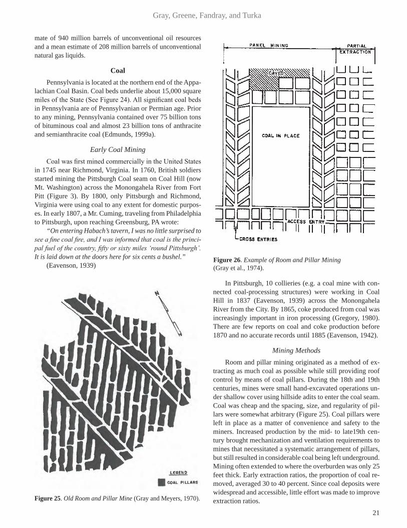
Mining MethodsRoom and pillar mining originated as a method of ex-
tracting as much coal as possible while still providing roof control by means of coal pillars. During the 18th and 19th centuries, mines were small hand-excavated operations un-der shallow cover using hillside adits to enter the coal seam. Coal was cheap and the spacing, size, and regularity of pil-lars were somewhat arbitrary (Figure 25). Coal pillars were left in place as a matter of convenience and safety to the miners. Increased production by the mid- to late19th cen-tury brought mechanization and ventilation requirements to mines that necessitated a systematic arrangement of pillars, but still resulted in considerable coal being left underground. Mining often extended to where the overburden was only 25 feet thick. Early extraction ratios, the proportion of coal re-moved, averaged 30 to 40 percent. Since coal deposits were widespread and accessible, little effort was made to improve extraction ratios.Figure 25. Old Room and Pillar Mine (Gray and Meyers, 1970).
Figure 26. Example of Room and Pillar Mining (Gray et al., 1974).
22
Geology of Pittsburgh
In the latter part of the 19th century, total extraction min-ing was initiated to achieve greater production of the coal that was becoming increasingly valued for its coking prop-erties by the steel industry, and as the preferred feedstock for manufactured gas plants, was first implemented in exist-ing partial extraction mines of the day. The distinction from partial extraction mines was the long, narrow pillars left be-tween rooms during first mining were now being extracted in a second stage of mining. Subsidence of the ground surface in a properly executed operation took place contemporane-ously with pillar extraction (Gray and Bruhn, 1984).
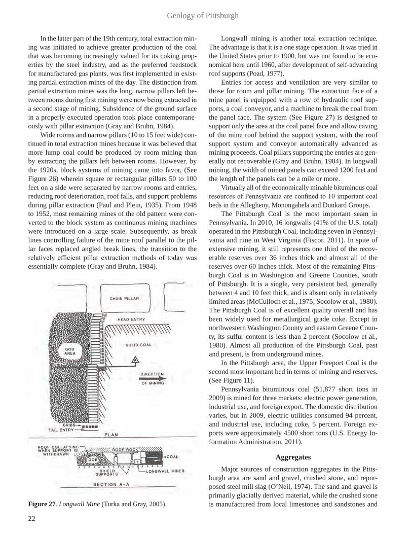
Wide rooms and narrow pillars (10 to 15 feet wide) con-tinued in total extraction mines because it was believed that more lump coal could be produced by room mining than by extracting the pillars left between rooms. However, by the 1920s, block systems of mining came into favor, (See Figure 26) wherein square or rectangular pillars 50 to 100 feet on a side were separated by narrow rooms and entries, reducing roof deterioration, roof falls, and support problems during pillar extraction (Paul and Plein, 1935). From 1948 to 1952, most remaining mines of the old pattern were con-verted to the block system as continuous mining machines were introduced on a large scale. Subsequently, as break lines controlling failure of the mine roof parallel to the pil-lar faces replaced angled break lines, the transition to the relatively efficient pillar extraction methods of today was essentially complete (Gray and Bruhn, 1984).
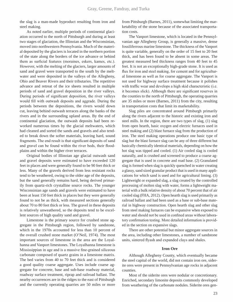
Longwall mining is another total extraction technique. The advantage is that it is a one stage operation. It was tried in the United States prior to 1900, but was not found to be eco-nomical here until 1960, after development of self-advancing roof supports (Poad, 1977).
Entries for access and ventilation are very similar to those for room and pillar mining. The extraction face of a mine panel is equipped with a row of hydraulic roof sup-ports, a coal conveyor, and a machine to break the coal from the panel face. The system (See Figure 27) is designed to support only the area at the coal panel face and allow caving of the mine roof behind the support system, with the roof support system and conveyor automatically advanced as mining proceeds. Coal pillars supporting the entries are gen-erally not recoverable (Gray and Bruhn, 1984). In longwall mining, the width of mined panels can exceed 1200 feet and the length of the panels can be a mile or more.
Virtually all of the economically minable bituminous coal resources of Pennsylvania are confined to 10 important coal beds in the Allegheny, Monongahela and Dunkard Groups.
The Pittsburgh Coal is the most important seam in Pennsylvania. In 2010, 16 longwalls (41% of the U.S. total) operated in the Pittsburgh Coal, including seven in Pennsyl-vania and nine in West Virginia (Fiscor, 2011). In spite of extensive mining, it still represents one third of the recov-erable reserves over 36 inches thick and almost all of the reserves over 60 inches thick. Most of the remaining Pitts-burgh Coal is in Washington and Greene Counties, south of Pittsburgh. It is a single, very persistent bed, generally between 4 and 10 feet thick, and is absent only in relatively limited areas (McCulloch et al., 1975; Socolow et al., 1980). The Pittsburgh Coal is of excellent quality overall and has been widely used for metallurgical grade coke. Except in northwestern Washington County and eastern Greene Coun-ty, its sulfur content is less than 2 percent (Socolow et al., 1980). Almost all production of the Pittsburgh Coal, past and present, is from underground mines.
In the Pittsburgh area, the Upper Freeport Coal is the second most important bed in terms of mining and reserves. (See Figure 11).
Pennsylvania bituminous coal (51,877 short tons in 2009) is mined for three markets: electric power generation, industrial use, and foreign export. The domestic distribution varies, but in 2009, electric utilities consumed 94 percent, and industrial use, including coke, 5 percent. Foreign ex-ports were approximately 4500 short tons (U.S. Energy In-formation Administration, 2011).
AggregatesMajor sources of construction aggregates in the Pitts-
burgh area are sand and gravel, crushed stone, and repur-posed steel mill slag (O’Neil, 1974). The sand and gravel is primarily glacially derived material, while the crushed stone is manufactured from local limestones and sandstones and Figure 27. Longwall Mine (Turka and Gray, 2005).
23
Gray, Greene, Fandray, and Turka
the slag is a man-made byproduct resulting from iron and steel making.
As noted earlier, multiple periods of continental glaci-ation occurred to the north of Pittsburgh and during at least two stages of glaciation, the Illinoian and the Wisconsinian, moved into northwestern Pennsylvania. Much of the materi-al deposited by the glaciers is located in the northern portion of the state along the borders of the ice advance or behind them as surficial features (moraines, eskers, kames, etc.). However, with the melting of the glaciers, larger amounts of sand and gravel were transported to the south by the melt-water and were deposited in the valleys of the Allegheny, Ohio and Beaver Rivers and their tributaries. The repetitive advance and retreat of the ice sheets resulted in multiple periods of sand and gravel deposition in the river valleys. During periods of significant deposition, the river valleys would fill with outwash deposits and aggrade. During the periods between the depositions, the rivers would down cut, leaving behind outwash terraces along the banks of the rivers and in the surrounding upland areas. By the end of continental glaciation, the outwash deposits had been re-worked numerous times by the glacial meltwaters, which had cleaned and sorted the sands and gravels and also tend-ed to break down the softer materials, leaving hard, sound fragments. The end result is that significant deposits of sand and gravel can be found within the river beds, their flood-plains and within the higher river terraces.
Original bodies of Illinoian age glacial outwash sand and gravel deposits were estimated to have exceeded 120 feet in places and were generally found to be 90 feet thick or less. Many of the gravels derived from less resistant rocks tend to be weathered, owing to the older age of the deposits, but the sand generally remains hard, being derived primar-ily from quartz-rich crystalline source rocks. The younger Wisconsinian age sands and gravels were estimated to have been at least 150 feet thick in places but they were generally found to not be as thick, with measured sections generally about 70 to 80 feet thick or less. The gravel in these deposits is relatively unweathered, so the deposits tend to be excel-lent sources of high quality sand and gravel.
Limestone is the primary source for crushed stone ag-gregate in the Pittsburgh region, followed by sandstone, which in the 1970s accounted for less than 10 percent of the overall crushed stone market (O’Neil, 1974). The most important sources of limestone in the area are the Loyal-hanna and Vanport limestones. The Loyalhanna limestone is Mississippian in age and is a massive fine-grained siliceous carbonate composed of quartz grains in a limestone matrix. The bed varies from 40 to 70 feet thick and is considered a good quality coarse aggregate. Uses include coarse ag-gregate for concrete, base and sub-base roadway material, roadway surface treatment, riprap and railroad ballast. The nearby occurrences are in the ridges to the east of Pittsburgh and the currently operating quarries are 50 miles or more
from Pittsburgh (Barnes, 2011), somewhat limiting the mar-ketability of the stone because of the associated transporta-tion costs.
The Vanport limestone, which is located in the Pennsyl-vanian age Allegheny Group, is generally a massive, dense fossiliferrous marine limestone. The thickness of the Vanport is quite variable, generally on the order of 15 feet to 20 feet thick, and has been found to be absent in some areas. The greatest measured bed thickness ranges from 40 feet to 45 feet. It is not an exceptionally high-grade stone. It is used as flux for iron and steel making, for cement and for agricultur-al limestone as well as for coarse aggregate. The Vanport is not used for highway surface treatment because it polishes with traffic wear and develops a high skid characteristic (i.e. it becomes slick). Although there are significant reserves in the counties to the north of Pittsburgh, the operating quarries are 35 miles or more (Barnes, 2011) from the city, resulting in transportation costs that limit its marketability.
Slag piles are concentrated around Pittsburgh primarily along the rivers adjacent to the historic and existing iron and steel mills. In the region, there are two types of slag, (1) slag from open hearth, basic oxygen and electric furnaces used in steel making and (2) blast furnace slag from the production of iron. The steel making operations produce one basic type of slag but the blast furnace slag can be any of three different but basically chemically identical materials, depending on how the hot slag was tipped and cooled. (1) Air cooled slag is cooled naturally, and is crushed and screened to produce a coarse ag-gregate that is used in concrete and road base. (2) Granulated slag is formed when slag is quickly quenched in water creating a glassy, sand sized granular product that is used in many appli-cations for which sand is used and for agricultural liming. (3) Lightweight or expanded slag, a slag created by the controlled processing of molten slag with water, forms a lightweight ma-terial with a bulk relative density of about 70 percent that of air cooled slag (FHA, 2012). Open hearth slag is used primarily as railroad ballast and had been used as a base or sub-base mate-rial in highway construction. Open hearth slag and other slag from steel making furnaces can be expansive when exposed to water and should not be used in confined areas without labora-tory confirmation testing. More detailed information is provid-ed in the section on expansive slags.
There are other potential but minor aggregate sources in the area, including other limestones, a number of sandstone units, sintered flyash and expanded clays and shales.
Iron OreAlthough Allegheny County, which eventually became
the steel capital of the world, did not contain iron ore, sider-ite ores were present in Pennsylvanian age rocks in adjacent counties.
Most of the siderite ores were nodular or concretionary. Enriched, secondary limonite deposits commonly developed from weathering of the carbonate nodules. Siderite ores gen-
24
Geology of Pittsburgh
erally ranged from 30 to 40 percent iron, whereas the en-riched limonitic derivatives averaged about 50 percent. In the early charcoal-iron furnaces, the lower grade unaltered siderite ores were mixed with limonitic ores from the same mine. The great era of carbonate-charcoal iron production in Western Pennsylvania lasted from 1825 to 1855. The last extensive mining of carbonate ore took place in Fayette and Westmoreland Counties prior to 1900 (Inners, 1999).
As the original hardwood forests were cleared, fuel for the iron furnaces switched in the 1850s to coal. About 1875, coal was replaced by coke (White, 1979) from local coal. Limestone flux was added to the furnaces to bond with mol-ten iron-ore impurities, creating a glassy slag.
The early Pittsburgh region furnaces produced cast iron which has a high carbon content (3-4.5 percent), making it brittle after casting. This cast iron was either cast direct-ly into goods or into ingots for transport to iron foundries where the ingots were converted into a more workable form, wrought iron (Hannibal et al., 2011).
Pennsylvania’s first iron furnace began production in 1692 (Hannibal et al., 2011). By the time of the American Revolution there were nearly 60 iron furnaces in Pennsylva-nia, and by 1841 there were well over 200 (Moldenke, 1920). Pittsburgh’s first iron furnace was erected in 1792. In the first half of the nineteenth century Pittsburgh was not known for its cast iron production, but for the foundries which convert-ed the cast iron into wrought iron (Moldenke, 1920).
Development of the Superior ore province in the Great Lakes region eventually put the iron mining industry of western Pennsylvania out of business. However, the iron and steel industry in Pittsburgh continued to grow because bitu-minous coal (and its coke) became an important ingredient in the process by the mid-1800s, and Pittsburgh was the hub of coal production. Eventually, Pittsburgh became the largest iron and steel producing center in the world (Gardner, 1980).
Water SupplyWater has always been readily available to Pittsburgh
and the surrounding communities from the abundance of surface water in the Allegheny, Monongahela and Ohio Riv-ers. Annual mean discharge data, based on nearby long-term USGS stream gaging stations, show the Allegheny River (USGS Water Data, Allegheny) at 19,750 cubic feet per second (cfs), the Monongahela River (USGS Water Data, Monongahela) at 12,650 cfs, resulting in flow at the head of the Ohio River (at Pittsburgh) of about 32,400 cfs.
The most plentiful groundwater source is from the gla-cial outwash alluvium that overlies the bedrock of the major stream valleys (Gallaher, 1973). This alluvial aquifer gener-ally consists of an older, basal portion that overlies bedrock, and an upper portion that was recently deposited. Ground-water is derived primarily from the basal portion of the al-luvium and the relative groundwater yield from it depends upon which river system it is located in. The Allegheny
Valley generally has the coarsest basal alluvium, composed primarily of sand and gravel derived from melting glaciers to the north, while the Monongahela Valley contains finer grained silts, sands and clays derived from the erosion of the local argillaceous rock lying east and south of Pittsburgh. Alluvium in the Ohio River is a mixture of alluvium from the two rivers. The permeability can change significantly over short distances within the alluvium, but for compara-tive purposes; well yields in the Ohio and Allegheny valleys average about 350 gallons per minute (gpm) while yields from the Monongahela valley wells average about 125 gpm.
Groundwater is available from the Pennsylvanian age rocks nearly everywhere in the Pittsburgh area, but the yields from wells tend to be significantly lower than from the alluvi-al deposits. The well yields from rock wells tend to be highly variable, with many of the yields being less than five gpm but
some wells reach yields of 75 to 100 gpm (Gallaher, 1973).The primary aquifers are the harder rocks (sandstones,
limestones) which have minimal primary permeability, but tend to fracture well, resulting in significant, natural second-ary permeability. Much of the secondary permeability in the sandstones and limestones is created by stress relief fracturing (Ferguson, 1967) caused by erosion and unloading of the rock units along stream valleys, along with tensional and compres-sional fracturing along the axes of the structural folds in the area. Valley stress release as discovered and described by Fer-guson (1967), and further described by Ferguson and Hamel (1981). This involves physical stress release changes to the physical integrity of the flat lying sedimentary rock layers as a valley is cut through the layers by erosion. As overburden is removed, stresses contained within the rocks are released. This generally manifests itself as open, tension-related, near vertical features in valley walls, and compression features tak-ing the form of low angle thrust faults in the valley floors. Harry Ferguson and his U.S. Army Corps of Engineers col-leagues observed this phenomenon in numerous excavations
Figure 28. Stress Relief Fractures (Wyrick and Borchers, 1981).

25
Gray, Greene, Fandray, and Turka
into Pittsburgh area river bottoms during construction of the series of Ohio River navigation locks and dams. Figure 28 illustrates the process of valley stress release.
There are 78 public water supply systems in Allegheny County that service 99 percent of the almost 1,225,000 coun-ty residents. The systems, including the system for the City of Pittsburgh, are overseen by the Allegheny County Health Department. Pittsburgh is serviced by the Pittsburgh Water and Sewer Authority (PWSA, 2014), which serves 196,000 water and sewer customers within the City.
The first documented public water supply system in Pitts-burgh was constructed in 1802 and consisted of four wells, serving a population of about 1600 residents. By 1828, the rapid growth of the City resulted in water shortages that even-tually required construction of a river pumping station along the Allegheny River. The station supplied 40,000 gallons of water per day. The systems were expanded and updated as the population grew and the City expanded, reaching 9 mil-lion gallons per day (mgd) by 1844, and 15 mgd by 1878, to service a population of 106,000 people. Water treatment was initiated in 1902, primarily using filtration. The first complete chemical treatment system of the water was installed in the
1960s, followed by replacement of slow sand filters with a dual media, rapid sand filter system in 1969 (PWSA, 2014).
Groundwater wells continued to be used in the City but were not the primary source of drinking water. In 1927, begin-ning with a well for the Stanley Theater, a number of the water wells in the City were drilled strictly for air conditioning pur-poses (Van Tuyl, 1951). By 1950, the volume of groundwater utilized for air conditioning had increased to about 500 mil-lion gallons per year, or about 25 percent of the total ground-water usage per year. On a daily rate basis, during the average air-conditioning season (100-120 days), the air conditioning use in 1950 was about 50 percent of the total groundwater use per day. Utilizing the alluvial aquifer under the City for air conditioning purposes has continued into the twenty-first century, as evidenced by the 2007 installation of a subsurface geothermal heat pump system into the alluvium underlying Point State Park (at the confluence of the three rivers) to heat as well as cool the blockhouse museum of Fort Pitt.
Hydropower Hydropower has been a part of the Pittsburgh region
for many years. Four of the U.S. Army Corps of Engineers
Figure 29. Aerial view of Allegheny Dam 5 and hydropower plant (Photo courtesy of the U.S. Army Corps of Engineers, Pittsburgh).

26
Geology of Pittsburgh
Pittsburgh District reservoirs currently generate hydropow-er: Kinzua Dam and Reservoir; Youghiogheny Dam and Reservoir; Conemaugh Dam and Reservoir; and the fourth, Mahoning Dam, recently started generating hydropower (Kurka et al., 2014). Kinzua Dam and Reservoir is located on the Allegheny River near Warren, PA. At this location, the electric utility First Energy (contemporary survivor of Associated Gas & Electric Co. [AGECO], 1906-1946) draws water both from the Corps of Engineers’ Allegheny Reservoir and also from a pumped storage reservoir located high above the left abutment of the dam. The project is a peaking plant, which means that it pumps water up to the storage reservoir at night when electric rates are low, and then sends the water down an inclined power tunnel to the power plant during the day when power demand is high. As mentioned, two other Corps’ reservoirs also have hy-dropower generation: Youghiogheny Dam, located south of Pittsburgh, and Conemaugh Dam, located northeast of Pittsburgh. Mahoning Dam is a concrete gravity structure also located northeast of Pittsburgh that was originally built with a penstock, allowing the project to be fitted for future power generation. The penstock has been retrofitted with a turbine and downstream power plant to generate hydropow-er. Construction of the power plant at Mahoning Dam has been completed.
There are five low head hydroelectric plants currently in place at existing locks and dams (L/D) near Pittsburgh. Four are located on the Allegheny River above Pittsburgh; L/D 5 (at Freeport, PA); L/D 6 (at Clinton, PA); L/D 8 (Temple-ton, PA); and L/D 9 (at Rimer, PA). The fifth is at Hannibal Locks and Dam, located on the Ohio River close to Wheel-ing, West Virginia. The four low head hydroelectric plants located on the Allegheny River were built in the late 1980s. Figure 29 provides an aerial view of the plant at Allegheny Dam 5 (Freeport, PA). At each of these five sites the gen-erating plant is located on the side of the river opposite the navigation lock. Power generation permits have been filed for many of the remaining navigation structures and flood control reservoirs by private electric power developers. Fed-eral tax credits have stimulated developers to file these per-mits; however, the Federal Energy Regulatory Commission licensing process is arduous, and therefore, at this time fur-ther hydropower development in the region will occur only gradually, consistent with the response of the Government.
GEOLOGIC CONSTRAINTS
Seismicity and Earthquake Hazard Southwest Pennsylvania, including Pittsburgh, is a rela-
tively inactive seismic area. Earthquake activity in surround-ing areas is somewhat more intense. These areas include the Piedmont Province in eastern Pennsylvania; northwestern Ohio; New York State, immediately east of Buffalo, at Atti-ca, New York; and in the St. Lawrence River Valley.
The largest earthquake-of-record in Pennsylvania, a magnitude 5.2, (mbLg) occurred on September 25, 1998, in northwestern Pennsylvania near the Ohio Border (Fleeger et al., 1999). However, Pennsylvania earthquakes are gen-erally small. Only twice per decade, on average, is an earth-quake epicentered within Pennsylvania that is large enough (Richter magnitude 3 or greater) to be felt in an area of sev-eral hundred square kilometers (Gordon and Dewey, 1999). The Pennsylvania Geologic Survey’s Map 69, Earthquake Catalog and Epicenter Map of Pennsylvania, (Faill, 2004) is the basic reference document showing the location of and listing all recorded seismic events since 1724 in Pennsyl-vania and surrounding areas. Some of the events that have been cataloged as “earthquakes” in the greater Ridge and Valley or Appalachian Plateaus Provinces were not tectonic earthquakes but mine explosions or related to mine subsid-ence (Gordon and Dewey, 1999).
About 35 earthquakes have caused slight damage in Penn-sylvania since the beginning of the American Colonial period. Occasional broken windows, cracked plaster and glassware toppled from shelves is characteristic of this type of damage. Nearly one half of these damaging events had out-of-state epi-centers. Foremost among this class of distant earthquakes that were felt strongly in Pennsylvania were a trio of major earth-quakes near New Madrid, MO in 1811-1812, and the Charles-ton, SC earthquake in 1886. Most earthquakes with epicenters inside the state have been located in southeastern Pennsylva-nia (Gordon and Dewey, 1999). Schamberger, 2003, provides general information on the nature, occurrence, history, and earthquake hazards in Pennsylvania.
Faults Bedrock faults in the Pittsburgh region exhibit relative-
ly small displacements. These include normal faults and thrust faults. The faults that have been identified to date are not capable of generating significant earthquakes. An exam-ple of a small offset normal fault near Pittsburgh is depicted
Figure 30. Small offset listric normal fault in a Glenshaw Formation marine to monmarive interval near Pittsburgh (Photo courtesy of John Harper, PA Geological Survey).
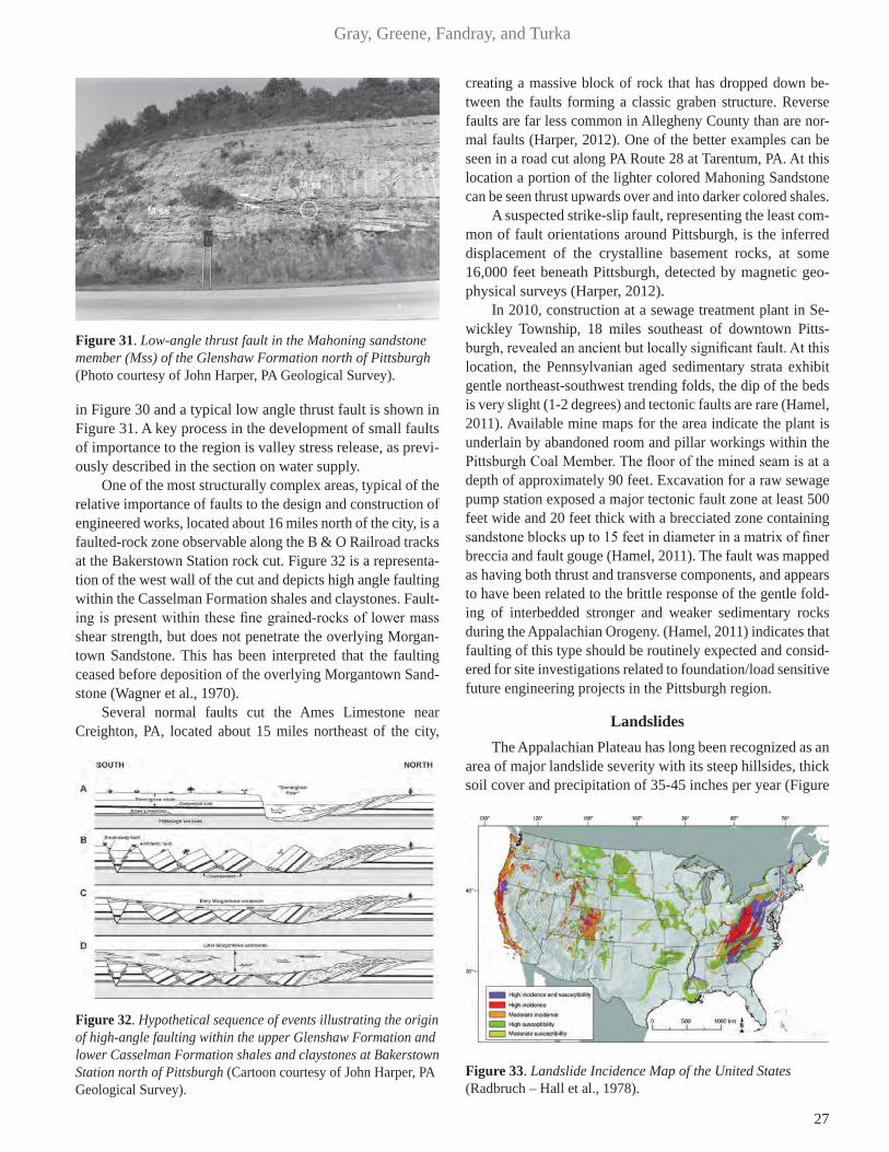
27
Gray, Greene, Fandray, and Turka
in Figure 30 and a typical low angle thrust fault is shown in Figure 31. A key process in the development of small faults of importance to the region is valley stress release, as previ-ously described in the section on water supply.
One of the most structurally complex areas, typical of the relative importance of faults to the design and construction of engineered works, located about 16 miles north of the city, is a faulted-rock zone observable along the B & O Railroad tracks at the Bakerstown Station rock cut. Figure 32 is a representa-tion of the west wall of the cut and depicts high angle faulting within the Casselman Formation shales and claystones. Fault-ing is present within these fine grained-rocks of lower mass shear strength, but does not penetrate the overlying Morgan-town Sandstone. This has been interpreted that the faulting ceased before deposition of the overlying Morgantown Sand-stone (Wagner et al., 1970).
Several normal faults cut the Ames Limestone near Creighton, PA, located about 15 miles northeast of the city,
creating a massive block of rock that has dropped down be-tween the faults forming a classic graben structure. Reverse faults are far less common in Allegheny County than are nor-mal faults (Harper, 2012). One of the better examples can be seen in a road cut along PA Route 28 at Tarentum, PA. At this location a portion of the lighter colored Mahoning Sandstone can be seen thrust upwards over and into darker colored shales.
A suspected strike-slip fault, representing the least com-mon of fault orientations around Pittsburgh, is the inferred displacement of the crystalline basement rocks, at some 16,000 feet beneath Pittsburgh, detected by magnetic geo-physical surveys (Harper, 2012).
In 2010, construction at a sewage treatment plant in Se-wickley Township, 18 miles southeast of downtown Pitts-burgh, revealed an ancient but locally significant fault. At this location, the Pennsylvanian aged sedimentary strata exhibit gentle northeast-southwest trending folds, the dip of the beds is very slight (1-2 degrees) and tectonic faults are rare (Hamel, 2011). Available mine maps for the area indicate the plant is underlain by abandoned room and pillar workings within the Pittsburgh Coal Member. The floor of the mined seam is at a depth of approximately 90 feet. Excavation for a raw sewage pump station exposed a major tectonic fault zone at least 500 feet wide and 20 feet thick with a brecciated zone containing sandstone blocks up to 15 feet in diameter in a matrix of finer breccia and fault gouge (Hamel, 2011). The fault was mapped as having both thrust and transverse components, and appears to have been related to the brittle response of the gentle fold-ing of interbedded stronger and weaker sedimentary rocks during the Appalachian Orogeny. (Hamel, 2011) indicates that faulting of this type should be routinely expected and consid-ered for site investigations related to foundation/load sensitive future engineering projects in the Pittsburgh region.
Landslides The Appalachian Plateau has long been recognized as an
area of major landslide severity with its steep hillsides, thick soil cover and precipitation of 35-45 inches per year (Figure
Figure 31. Low-angle thrust fault in the Mahoning sandstone member (Mss) of the Glenshaw Formation north of Pittsburgh (Photo courtesy of John Harper, PA Geological Survey).
Figure 32. Hypothetical sequence of events illustrating the origin of high-angle faulting within the upper Glenshaw Formation and lower Casselman Formation shales and claystones at Bakerstown Station north of Pittsburgh (Cartoon courtesy of John Harper, PA Geological Survey).
Figure 33. Landslide Incidence Map of the United States (Radbruch – Hall et al., 1978).

28
Geology of Pittsburgh
33). It is a naturally dissected upland surface developed on gently folded but essentially flat-lying sedimentary rocks.
Slope FormationCurrent slope development in the unglaciated por-
tion of the Appalachian Plateau is consistent with flat-ly-ing sedimentary rocks in a temperate, humid climate. The occurrence of alternating weak and resistant rock strata is reflected topographically by breaks in slope and somewhat subdued due to well-developed erosional benches (Gray et al., 1979; Gray and Gardner, 1977).
Existing and past climatic conditions, including peri-glacial effects, have resulted in substantial mechanical and chemical weathering, which produced a residual or collu-vial soil mantle over almost the entire rock surface. The most significant periglacial effects were the greater rates of weathering, increased soil formation and subsequent mass wasting (Denny, 1956; Philbrick, 1961; Rapp, 1967).
Downslope movement of the soil results in its accumu-lation at the toes of slopes in colluvial masses. These collu-vial soils tend to be 5 – 30 feet thick on slopes and generally increase in thickness (to a maximum of about 100 feet) near the toes of slopes unless there is active stream erosion (See Figure 34). Colluvial soils are generally stiff to hard, and individual samples have relatively high shear strengths. However, creep or sliding processes (or both) during slope development generally reduce the shear strength along movement surfaces to residual or near-residual levels (Gray et al., 1979). These low strength shear surfaces can occur at several levels within the colluvial mass but there is al-ways a low strength shear surface at the soil-rock interface (Deere and Patton, 1971). As the slope materials seek equi-librium between stress and strength, the soil mantle moves downslope and the mean slope angle decreases, until a state of marginal equilibrium is achieved. This natural slope-flat-tening process accounts for the relatively thick soil cover on
mature colluvial slopes, particularly at the base of slopes. Deere and Patton (1971) have suggested that there are no stable natural slopes in the Appalachian Plateau where the slope inclination exceeds 12-14°. Terzaghi and Peck (1948), report movements on slopes as flat as 10°, whereas Gray and Donovan (1971) demonstrated that several mature col-luvial slopes, with evidence of pre-existing failure surfaces, had slope angles ranging from 7° to 10°. Gray and Gardner (1977) presented observations on the development of collu-vial slopes.
Numerous field observations suggest that colluvial slopes, which may creep at rates of a few centimeters per year, visually appear stable unless disturbed by cutting, filling, drainage changes, or extreme precipitation events (Gray et al., 2011).
Landsliding As stated above, the Appalachian Plateau is recognized
as having some of the most severe landsliding in the United States (Ladd, 1927-1928; Sharpe and Dosch, 1942; Acken-heil, 1954; Eckel, 1958; Baker and Chieruzzi, 1959). Most landslides in the Appalachian Plateau occur in hillside soil masses, with the most common being slump-type slides or slow earth flows which range in size up to several million cubic yards. Rockfalls, the next most common type of slide in the area, are typically much smaller with maximum vol-umes on the order of a few hundred cubic yards. The best documented rockslide occurred at the Brilliant Cut in Pitts-burgh in 1941 (Hamel, 1972), (See landslide case histories in the following section). At present, deep-seated rockslides are uncommon in the area. However, during the Pleistocene Epoch, when climate was more severe and rivers were rapidly downcutting their valleys, this type of slide is believed to have been common. Other types of slide movements are relatively rare. Injuries and fatalities due to landslides are rare and result mainly from rockfalls on highway slopes and soil falls in con-struction trench excavations.
Residual strength values play an important role in the evaluation of landslides and the design of remedial measures in the area. The colluvium generally exhibits strain-softening behavior (Skempton, 1964) and its residual (large displace-ment) shear strength is generally less than half its peak (small displacement) strength at a given effective normal stress. For effective normal stresses of less than about 50 psi, the peak strength of claystone colluvium is commonly characterized by cohesion intercepts of one to five psi and friction angles of 20-25°, while the residual strength is usually characterized by negligible cohesion intercepts and friction angles of 8-20°. Measured residual friction angles for most claystone-derived colluvium are on the order of 11-16° (Gray et al., 1979). Ex-perience in calculation of strength data from colluvial slide masses (Hamel, 1969; Hamel and Flint, 1969; Hamel and Flint 1972; Gray and Donovan, 1971; Hamel, 1980, 2004) indicates
Figure 34. Thick Colluvial Soil Cover Colluvial masses develop having volumes of several million cubic meters and thickness of up to 30 m. Mature colluvial slopes may exhibit angles as flat as 7 – 10°. Many large colluvial masses interfinger with glacial outwash, and radiocarbon dating indicates they may have formed under periglacial conditions.
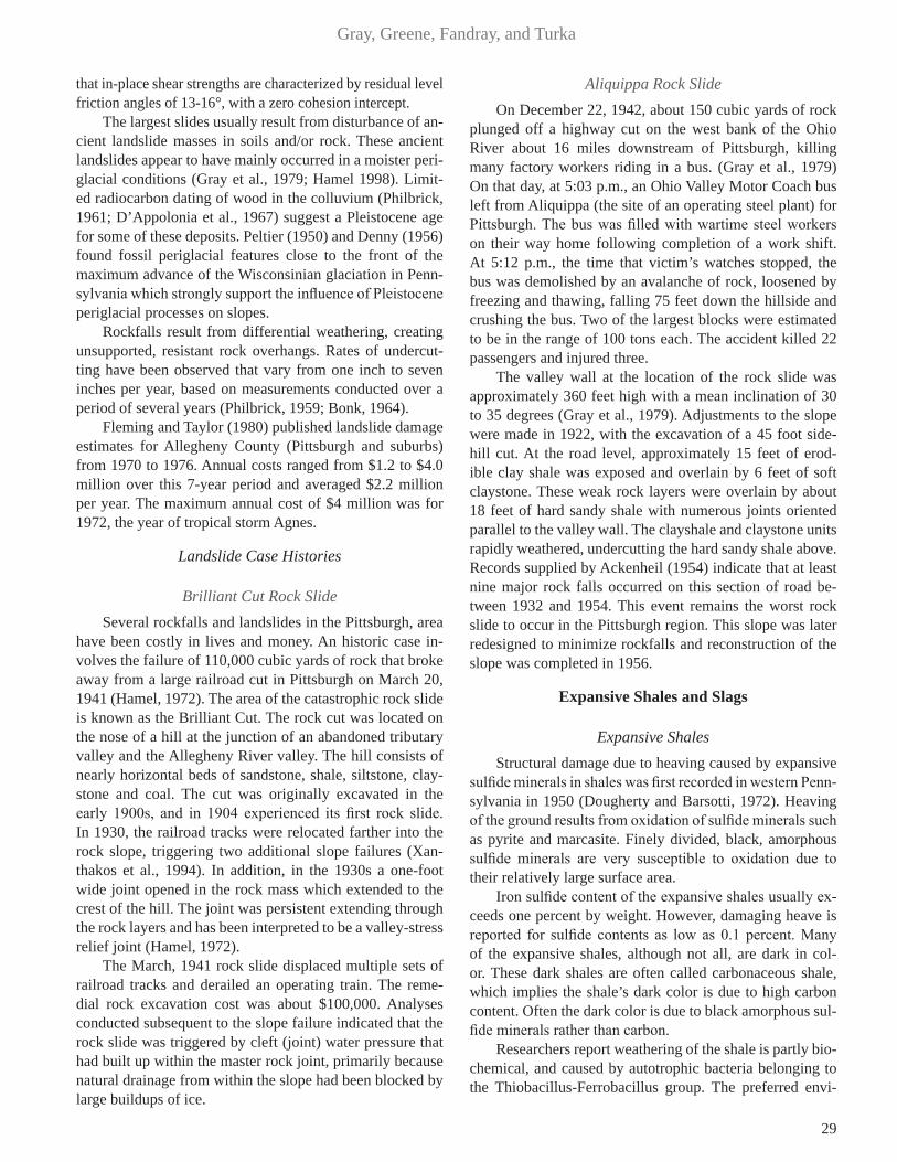
29
Gray, Greene, Fandray, and Turka
that in-place shear strengths are characterized by residual level friction angles of 13-16°, with a zero cohesion intercept.
The largest slides usually result from disturbance of an-cient landslide masses in soils and/or rock. These ancient landslides appear to have mainly occurred in a moister peri-glacial conditions (Gray et al., 1979; Hamel 1998). Limit-ed radiocarbon dating of wood in the colluvium (Philbrick, 1961; D’Appolonia et al., 1967) suggest a Pleistocene age for some of these deposits. Peltier (1950) and Denny (1956) found fossil periglacial features close to the front of the maximum advance of the Wisconsinian glaciation in Penn-sylvania which strongly support the influence of Pleistocene periglacial processes on slopes.
Rockfalls result from differential weathering, creating unsupported, resistant rock overhangs. Rates of undercut-ting have been observed that vary from one inch to seven inches per year, based on measurements conducted over a period of several years (Philbrick, 1959; Bonk, 1964).
Fleming and Taylor (1980) published landslide damage estimates for Allegheny County (Pittsburgh and suburbs) from 1970 to 1976. Annual costs ranged from $1.2 to $4.0 million over this 7-year period and averaged $2.2 million per year. The maximum annual cost of $4 million was for 1972, the year of tropical storm Agnes.
Landslide Case Histories
Brilliant Cut Rock SlideSeveral rockfalls and landslides in the Pittsburgh, area
have been costly in lives and money. An historic case in-volves the failure of 110,000 cubic yards of rock that broke away from a large railroad cut in Pittsburgh on March 20, 1941 (Hamel, 1972). The area of the catastrophic rock slide is known as the Brilliant Cut. The rock cut was located on the nose of a hill at the junction of an abandoned tributary valley and the Allegheny River valley. The hill consists of nearly horizontal beds of sandstone, shale, siltstone, clay-stone and coal. The cut was originally excavated in the early 1900s, and in 1904 experienced its first rock slide. In 1930, the railroad tracks were relocated farther into the rock slope, triggering two additional slope failures (Xan-thakos et al., 1994). In addition, in the 1930s a one-foot wide joint opened in the rock mass which extended to the crest of the hill. The joint was persistent extending through the rock layers and has been interpreted to be a valley-stress relief joint (Hamel, 1972).
The March, 1941 rock slide displaced multiple sets of railroad tracks and derailed an operating train. The reme-dial rock excavation cost was about $100,000. Analyses conducted subsequent to the slope failure indicated that the rock slide was triggered by cleft (joint) water pressure that had built up within the master rock joint, primarily because natural drainage from within the slope had been blocked by large buildups of ice.
Aliquippa Rock Slide On December 22, 1942, about 150 cubic yards of rock
plunged off a highway cut on the west bank of the Ohio River about 16 miles downstream of Pittsburgh, killing many factory workers riding in a bus. (Gray et al., 1979) On that day, at 5:03 p.m., an Ohio Valley Motor Coach bus left from Aliquippa (the site of an operating steel plant) for Pittsburgh. The bus was filled with wartime steel workers on their way home following completion of a work shift. At 5:12 p.m., the time that victim’s watches stopped, the bus was demolished by an avalanche of rock, loosened by freezing and thawing, falling 75 feet down the hillside and crushing the bus. Two of the largest blocks were estimated to be in the range of 100 tons each. The accident killed 22 passengers and injured three.
The valley wall at the location of the rock slide was approximately 360 feet high with a mean inclination of 30 to 35 degrees (Gray et al., 1979). Adjustments to the slope were made in 1922, with the excavation of a 45 foot side-hill cut. At the road level, approximately 15 feet of erod-ible clay shale was exposed and overlain by 6 feet of soft claystone. These weak rock layers were overlain by about 18 feet of hard sandy shale with numerous joints oriented parallel to the valley wall. The clayshale and claystone units rapidly weathered, undercutting the hard sandy shale above. Records supplied by Ackenheil (1954) indicate that at least nine major rock falls occurred on this section of road be-tween 1932 and 1954. This event remains the worst rock slide to occur in the Pittsburgh region. This slope was later redesigned to minimize rockfalls and reconstruction of the slope was completed in 1956.
Expansive Shales and Slags
Expansive Shales Structural damage due to heaving caused by expansive
sulfide minerals in shales was first recorded in western Penn-sylvania in 1950 (Dougherty and Barsotti, 1972). Heaving of the ground results from oxidation of sulfide minerals such as pyrite and marcasite. Finely divided, black, amorphous sulfide minerals are very susceptible to oxidation due to their relatively large surface area.
Iron sulfide content of the expansive shales usually ex-ceeds one percent by weight. However, damaging heave is reported for sulfide contents as low as 0.1 percent. Many of the expansive shales, although not all, are dark in col-or. These dark shales are often called carbonaceous shale, which implies the shale’s dark color is due to high carbon content. Often the dark color is due to black amorphous sul-fide minerals rather than carbon.
Researchers report weathering of the shale is partly bio-chemical, and caused by autotrophic bacteria belonging to the Thiobacillus-Ferrobacillus group. The preferred envi-
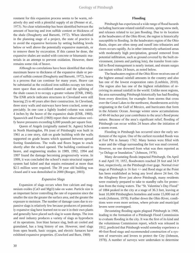
30
Geology of Pittsburgh
ronment for this expansion process seems to be warm, rel-atively dry and with a plentiful supply of air (Penner et al., 1973). No clear relationship has been identified between the amount of heaving and iron sulfide content or thickness of the shale (Dougherty and Barsotti, 1972). When identified in the planning stage of a project, the state of practice is to avoid the expansive horizons by setting building levels below or well above the potentially expansive materials, or to remove them by excavation. If this cannot be done, the expansive shales are sealed with concrete or bitumastic ma-terials in an attempt to prevent oxidation. However, there remains some risk of heave.
Although no correlations have been identified that relate maximum heave to thickness of the expansive shale or per-cent of sulfide content (Dougherty and Barsotti, 1972), heave is a process that can continue for many years. Heave can be substantial as the oxidized iron sulfides occupy ten times more space than un-oxidized material and the splitting of the shale causes it to occupy a greater volume (ENR, 1960). The ENR article indicates structures in Cleveland were still heaving 25 to 40 years after their construction. In Cleveland, three story walls and stairways have been cracked, some ap-preciably. In one case a lightly loaded column was raised 4 inches by the heave of the expansive shale (ENR, 1960). Spanovich and Fewell (1969) report their observations veri-fy heave pressures exceeding 6,000 pounds per square foot.
Queen of Angels (originally named St. Agnes) School in North Huntingdon, PA (east of Pittsburgh) was built in 1961 as a one story, slab on grade building with the walls supported on grade beams which spanned between spread footing foundations. The walls and floors began to crack shortly after the school opened. The building continued to heave, and engineering studies in 1989, 1992, 1994 and 1997 found the damage becoming progressively worse. In 1999, it was concluded the school’s main structural support system had failed and that repairs estimated at more than $2.5 million were required. The 39 year old building was closed and it was demolished in 2000 (Reeger, 2003).
Expansive SlagsExpansion of slags occurs when free calcium and mag-
nesium oxides (CaO and MgO) take on water. Particle size is an important factor controlling the rate of expansion since the smaller the size the greater the surface area, and the greater the exposure to moisture. The number of damage cases due to ex-pansive slags is relatively few because producers of potential-ly expansive slag have learned not to use it in their own plants and generally have placed such slag in waste dumps. The iron and steel industry produces a variety of slags as byproducts of its operations. Iron blast furnace slag, both air cooled and granulated, has a long history of use. However, steel slags from open hearth, basic oxygen, and electric furnaces have exhibited expansive properties. (Crawford and Burn, 1969)
Flooding Pittsburgh has experienced a wide range of flood hazards
including hurricane related rainfall events, spring snow melt, and releases related to ice jam flooding. Due to its location at the headwaters of the Ohio River, the region is historically susceptible to flooding. In the headwaters region of the Ohio Basin, slopes are often steep and runoff into tributaries and rivers occurs rapidly. As in other intensively-urbanized areas with moderately high precipitation, ground removed from potential infiltration, such as ground covered by the built en-vironment, (streets and parking lots), the transfer from rain-fall to flood management is nearly instant, and stream surges can mount within 24 hours, as noted below.
The headwaters region of the Ohio River receives one of the highest annual rainfall amounts in the country and also has one of the lowest evaporation rates (Loehlein, 2010). The region also has one of the highest reliabilities of re-ceiving its annual rainfall in the world. Unlike most regions, the area surrounding Pittsburgh historically has had flooding from every direction; for example: from storms that cross over the Great Lakes to the northwest, thunderstorm activity originating in the Gulf of Mexico, and hurricanes that form in the Atlantic Ocean. Average winter snow accumulations of 40-60 inches per year contributes to the area’s flood prone nature. Because of the area’s significant relief, flooding of Pittsburgh can occur within 24 hours after the initiation of a storm event.
Flooding in Pittsburgh has occurred since the early set-tlement of the region. One of the earliest recorded floods was at Fort Pitt in January 1762. Many homes were filled with water and the village surrounding the fort was mud covered. However, no one drowned from what was then reported as “ye Deluge or Inundation.” (Johnson, 1978).
Many devastating floods impacted Pittsburgh. On April 6 and April 19, 1852, floodwaters reached 28 feet and 34.9 feet, respectively, on the Pittsburgh river gage. Normal river stage at Pittsburgh is 16 feet +/- and flood stage at the Point has been established as being any level above 24 feet. On the Allegheny River just above Pittsburgh, many residents were routinely prepared to take to standby rafts for protec-tion from the rising waters. The “St. Valentine’s Day Flood” of 1884 peaked in the city at a stage of 36.3 feet, leaving at least 10,000 Pittsburghers homeless and some 15,000 out of work (Johnson, 1978). Further down the Ohio River, condi-tions were even more serious, where private and municipal levees were overtopped.
Devastating flooding again plagued Pittsburgh in 1908, leading to the formation of a Pittsburgh Flood Commission to evaluate flooding in the city. It was the first of its kind and the voluminous Commission report, which was released in 1912, predicted that Pittsburgh would someday experience a 40-foot flood stage and recommended construction of a sys-tem of reservoirs and levees to protect the City (Johnson, 1978). A number of surveys were undertaken to determine

31
Gray, Greene, Fandray, and Turka
the optimal sites for dams that would impound reservoirs and act to attenuate flooding downstream. Some of the major riv-er systems evaluated for such projects were the Allegheny, Mahoning, and Shenango rivers. Following a flood in 1913, the U.S. Army Corps of Engineers took a more aggressive approach to flooding problems. This was likely a direct reac-tion to the strong opinions of then President Theodore Roos-evelt, who was quoted as saying, while the flood of 1913 was still receding: “We are spending millions for relief of flood victims, but not one cent to solve flood problems.” Roosevelt declared that it was imperative for the Federal Government to build multipurpose dams and reservoirs to conserve flood waters to later use for irrigation, hydroelectric power genera-tion, and improving dry season flows (Johnson, 1978). In di-rect response to this national attention, the Ohio River Flood Board was formed to initiate America’s first regional flood
mitigation planning. Additional floods impacted Pittsburgh, with the most significant one occurring in March 1936. That flood peaked at over thirty feet above normal river level (46.4 feet actual water depth). This event was then calculated to represent a record setting 500-year flood, and considered to be the worst flood to impact the Pittsburgh region and the city (See Figure 35). Subsequently, flood control was initi-ated by the Corps of Engineers in 1938. The severity of the flooding in Pittsburgh was greatly reduced during the more recent floods that occurred in 1972, associated with Hurri-cane Agnes, and in 1996, by the system of upstream flood control reservoirs.
The Great Flood of 1889 On May 31, 1889, approximately 60 miles east of Pitts-
burgh, a man-made disaster of unrivaled proportions took place in the City of Johnstown, Pennsylvania. It was the Johnstown Flood (or the “Great Flood of 1889” as it became known locally). Heavy rains poured down over this direct upper sub-basin of the Ohio River for several days (Law, 1997). The area surrounding Johnstown remains naturally prone to flooding due to its position at the confluence of the Little Conemaugh River and Stony Creek, which form the Conemaugh River. The area above Johnstown consists of a 657 square-mile watershed within the Allegheny Plateau. Adding to these factors, artificial narrowing of the riverbed because of early industrial development made the city even more flood-prone. The Conemaugh River immediately down-stream of Johnstown is hemmed in by steep mountain slopes.
Upstream of Johnstown, near the small town of South Fork, the South Fork Dam was originally built between 1838 and 1853 by the Commonwealth of Pennsylvania as part of a canal water delivery system to be used as a source of water for a canal basin in Johnstown (McCullough, 1968). With railroads superseding canal barge transport, the obsolete South Fork Lake was sold to the Pennsylvania Railroad, and later sold again to private interests. A group of notable Pitts-burgh businessmen, including coal and coke magnate Henry Clay Frick, and Andrew Carnegie led a group to purchase the reservoir, modify it, and convert it into a private resort lake for wealthy industrialists of Pittsburgh. They built cot-tages and a clubhouse to create the South Fork Fishing and Hunting Club, an exclusive mountain retreat. Membership grew to include over 50 wealthy Pittsburgh steel, coal, and railroad industrialists. Changes to the lake, which was re-named Lake Conemaugh, included lowering the dam, which impounded the lake to make its top wide enough to hold a road, and putting a fish screen in the spillway, which unfor-tunately could also trap debris. These alterations increased the vulnerability of the dam to overtopping.
Lake Conemaugh sat at 450 feet in elevation above Johnstown. The lake was about 2 miles long, approximately 1 mile wide, and 60 feet deep near the dam. The lake had a perimeter of 7 miles and held 20 million tons of water. When the water was at its highest point in the spring, the lake covered over 400 acres. The dam was 72 feet high and 931 feet long. Between 1881, when the club was opened, and 1889, the dam frequently leaked and was patched, mostly with mud and straw. Additionally, a previous owner removed and sold for scrap the three cast iron discharge pipes that previously allowed a controlled release of water, as a form of safety-related control of the impounded water level. There had been some speculation as to the dam’s integrity, raised by the head of the Cambria Iron Works, which was located directly downstream, in Johnstown. Carnegie Steel’s chief competitor, the Cambria Iron Works, at that time boasted the
Figure 35. Fort Pitt Blockhouse – Historical flood levels at the Point (Photo courtesy of the U.S. Army Corps of Engineers).
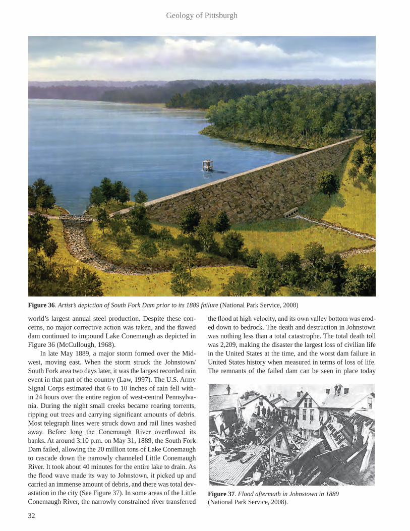
32
Geology of Pittsburgh
world’s largest annual steel production. Despite these con-cerns, no major corrective action was taken, and the flawed dam continued to impound Lake Conemaugh as depicted in Figure 36 (McCullough, 1968).
In late May 1889, a major storm formed over the Mid-west, moving east. When the storm struck the Johnstown/South Fork area two days later, it was the largest recorded rain event in that part of the country (Law, 1997). The U.S. Army Signal Corps estimated that 6 to 10 inches of rain fell with-in 24 hours over the entire region of west-central Pennsylva-nia. During the night small creeks became roaring torrents, ripping out trees and carrying significant amounts of debris. Most telegraph lines were struck down and rail lines washed away. Before long the Conemaugh River overflowed its banks. At around 3:10 p.m. on May 31, 1889, the South Fork Dam failed, allowing the 20 million tons of Lake Conemaugh to cascade down the narrowly channeled Little Conemaugh River. It took about 40 minutes for the entire lake to drain. As the flood wave made its way to Johnstown, it picked up and carried an immense amount of debris, and there was total dev-astation in the city (See Figure 37). In some areas of the Little Conemaugh River, the narrowly constrained river transferred
the flood at high velocity, and its own valley bottom was erod-ed down to bedrock. The death and destruction in Johnstown was nothing less than a total catastrophe. The total death toll was 2,209, making the disaster the largest loss of civilian life in the United States at the time, and the worst dam failure in United States history when measured in terms of loss of life. The remnants of the failed dam can be seen in place today
Figure 36. Artist’s depiction of South Fork Dam prior to its 1889 failure (National Park Service, 2008)
Figure 37. Flood aftermath in Johnstown in 1889 (National Park Service, 2008).

33
Gray, Greene, Fandray, and Turka
Figure 38. Current photograph of South Fork Dam depicting abutment remnants (National Park Service, 2008).
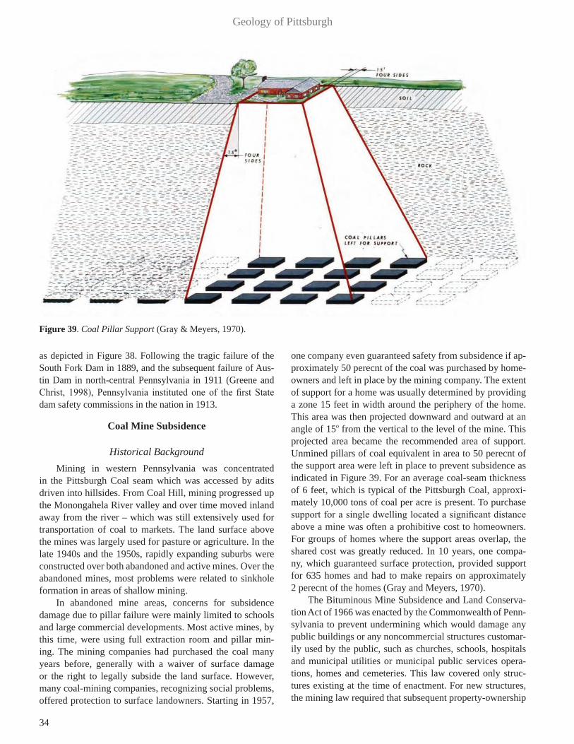
34
Geology of Pittsburgh
as depicted in Figure 38. Following the tragic failure of the South Fork Dam in 1889, and the subsequent failure of Aus-tin Dam in north-central Pennsylvania in 1911 (Greene and Christ, 1998), Pennsylvania instituted one of the first State dam safety commissions in the nation in 1913.
Coal Mine Subsidence
Historical BackgroundMining in western Pennsylvania was concentrated
in the Pittsburgh Coal seam which was accessed by adits driven into hillsides. From Coal Hill, mining progressed up the Monongahela River valley and over time moved inland away from the river – which was still extensively used for transportation of coal to markets. The land surface above the mines was largely used for pasture or agriculture. In the late 1940s and the 1950s, rapidly expanding suburbs were constructed over both abandoned and active mines. Over the abandoned mines, most problems were related to sinkhole formation in areas of shallow mining.
In abandoned mine areas, concerns for subsidence damage due to pillar failure were mainly limited to schools and large commercial developments. Most active mines, by this time, were using full extraction room and pillar min-ing. The mining companies had purchased the coal many years before, generally with a waiver of surface damage or the right to legally subside the land surface. However, many coal-mining companies, recognizing social problems, offered protection to surface landowners. Starting in 1957,
one company even guaranteed safety from subsidence if ap-proximately 50 perecnt of the coal was purchased by home-owners and left in place by the mining company. The extent of support for a home was usually determined by providing a zone 15 feet in width around the periphery of the home. This area was then projected downward and outward at an angle of 15o from the vertical to the level of the mine. This projected area became the recommended area of support. Unmined pillars of coal equivalent in area to 50 perecnt of the support area were left in place to prevent subsidence as indicated in Figure 39. For an average coal-seam thickness of 6 feet, which is typical of the Pittsburgh Coal, approxi-mately 10,000 tons of coal per acre is present. To purchase support for a single dwelling located a significant distance above a mine was often a prohibitive cost to homeowners. For groups of homes where the support areas overlap, the shared cost was greatly reduced. In 10 years, one compa-ny, which guaranteed surface protection, provided support for 635 homes and had to make repairs on approximately 2 perecnt of the homes (Gray and Meyers, 1970).
The Bituminous Mine Subsidence and Land Conserva-tion Act of 1966 was enacted by the Commonwealth of Penn-sylvania to prevent undermining which would damage any public buildings or any noncommercial structures customar-ily used by the public, such as churches, schools, hospitals and municipal utilities or municipal public services opera-tions, homes and cemeteries. This law covered only struc-tures existing at the time of enactment. For new structures, the mining law required that subsequent property-ownership
Figure 39. Coal Pillar Support (Gray & Meyers, 1970).

35
Gray, Greene, Fandray, and Turka
deeds, indicate the existence or lack of existence of subsur-face support. Prior to mining, the coal company was required to contact property owners and assign a price for leaving coal pillar support as previously described. If the price was not agreeable to the property owner, then the Secretary of the State Department of Mines and Mineral Industries assigned a mediator to determine just compensation for the coal to be left in place for surface support (Gray and Meyers, 1970). The Surface Mining Control and Reclamation Act of 1977 imposed land use controls on active mines. This law requires an evaluation of whether subsidence can occur and cause material damage or diminution of use of structures or renew-able resource lands. If a potential for damage is present, a plan to prevent or mitigate the damage is required.
Coal Extraction and SubsidenceSubsidence does not occur until mining removes a sig-
nificant amount of coal. What is significant is related to the geometry of the mine, its depth and the physical characteris-tics of the coal and overlying rock strata. In many ways, all interests are met if complete extraction occurs in a large part of the mine, which results in subsidence of the ground sur-face contemporaneously with mining. Many mines in oper-ation today utilize longwall mining, which removes all coal from large areas, or total extraction room and pillar mining, which systematically removes the coal pillars from one end of a large panel to the other. Total extraction in room and pil-lar mines has been practiced in the Pittsburgh region since the latter part of the 19th century.
Subsidence contemporaneous with longwall or total ex-traction room and pillar mining is similar and ceases in a few
months to a few years after mining. However, other mines only remove a portion of the coal leaving pillars of coal in place. Uniformly spaced pillars, if of sufficient size relative to the strength of the mine roof, floor and coal itself, can sup-port the overlying rock strata without subsidence. If the coal pillars are too weak, subsidence will eventually occur. This is the case with many old mines. Subsidence over abandoned mines may continue for many years and is often sporadic.
The availability and quality of mine maps varies throughout the United States. In the Pittsburgh region mine maps are usually available for all but the earliest or very small mines. Large mining companies became common af-ter the Civil War resulting in excellent maps. Gray et al., (1996) discuss mine map accuracy.
Mining Related Ground MovementsThe angle-of-draw defines the limits of subsidence over
a particular mined-out area. However, small movements out-side the angle of draw and associated with longwall mining were recognized about 20 years ago in Australia (Hebble-white, 2001). Although the mechanism of these movements remains uncertain, possible explanations include one, or a combination of factors, such as post-mining stress relax-ation, valley bulging, regional joint patterns, shearing of valley walls and bedding-plane shear failure (Hebblewhite, 2001). These movements, sometimes described as far-field movements, may occur over a mile from the longwall panel, and, thus, well outside the angle of draw (Waddington and Associates, 2002; Hebblewhite, 2001).
Similar movements have been recently recognized in southwestern Pennsylvania in studies of longwall mining
Figure 40. Modes of Mine Subsidence (Gray, 1999).

36
Geology of Pittsburgh
under Interstate 70 (GeoTDR, Inc. 2001) and in the remedi-al investigation of leakage of Ryerson Dam in 2005 (Heb-blewhite and Gray, 2014). In monitoring the mining under Interstate 70, Time Domain Reflectometry (TDR) cables, in-stalled in deep boreholes, recorded deformations over 1000 feet in front of the advancing mine panel, well beyond the limits of theoretically anticipated movement around the ac-tive mine panel (GeoTDR, Inc. 2001). Mining of a longwall panel 2500 feet south of Ryerson Dam is the only apparent concurrent cause of bedding-plane slip in rock beneath the dam, which was recorded by slope inclinometers (Hebble-white and Gray, 2014a).
Subsidence ModesTopographic ground surface subsidence features over
mines are classified as sinkholes or troughs (Figure 40). A sinkhole is a depression in the ground surface that occurs from collapse of the overburden into a mine opening (a room or an entry). A trough is a shallow, commonly broad, dish-shaped depression that develops when the overburden sags downward into a mine opening in response to coal ex-traction, crushing of mine pillars, or punching of pillars into the mine floor. Troughs develop over both active and aban-doned mines. There appears to be no safe depth of mining that prevents trough development.
Sinkholes generally develop where the cover above a mine is relatively thin (Figure 41). Competent strata above the coal limit sinkhole development (Figure 40). Piggott and Eynon (1978) indicated that sinkhole development normally occurs where the interval to the ground surface is less than three to five times the thickness of the extracted seam, and that the maximum overburden interval is up to 10 times the thickness of the extracted seam. In western Pennsylvania, most sinkholes develop where the soil and rock above a mine are less than 50 feet thick (Bruhn et al., 1978). A study of subsidence in the Pittsburgh area revealed that the major-ity of sinkholes, which constituted about 95 percent of all reported subsidence incidents, occurred on sites located less
than 60 feet above mine level (Bruhn et al., 1981).
Abandoned MinesFigures 42 and 43 show subsidence damage over aban-
doned mines. It appears that: (1) Unless total extraction has occurred, there is no in-
terval above an abandoned mine that is safe from subsidence, nor is there necessarily a reduction in severity of damage with increased intervals;
(2) Subsidence occurs at reduced frequency with in-creasing overburden thickness; and,
(3) Unless total extraction has been achieved, subsid-ence may occur long after mining and may not be limited to a single episode (Gray, 1988).
Item (3) implies that the possibility of future subsid-ence at a site cannot be ruled out merely because subsidence has not occurred in the first 50 to 100 years after mining. If abandoned mine openings beneath a site have not been designed for long-term stability, the potential for subsidence remains until the openings collapse, or until they are sta-bilized by backfilling, grout columns, or some other engi-neered remedial ground-support means (Gray et al., 1974).
Figure 41. Coal Mine Sinkhole (Photo by R. Gray, 1969).
Figure 42. Building Damage Caused by Subsidence – Coal at 175 feet (Gray, 1999).
Figure 43. House Damaged by Sinkhole Subsidence – Connellsville, PA (Photo by R. Turka, 1979).

37
Gray, Greene, Fandray, and Turka
Precisely when collapse might take place in the absence of stabilization is not predictable. Even after subsidence has taken place at a particular site, the possibility of future addi-tional subsidence may remain. Multiple episodes of subsid-ence have been documented at many sites in the Pittsburgh region (Gray et al., 1977). Pillar failure can fall into three general categories: delayed, progressive, or sporadic (Abel and Lee, 1980). Site surveillance programs of a few months’ duration or, in fact, indefinite duration cannot provide defin-itive evidence that a site overlying a mine with open voids will not experience future subsidence (Bruhn et al., 1981).
Insurance programs to provide assistance, if and when subsidence occurs, appear desirable (DuMontelle et al., 1981). Pennsylvania and other states have mine-subsidence insurance programs. Such an approach appears more desir-able than large-scale urban stabilization programs for resi-dential areas (Gray, 1983).
Volcanism The Pittsburgh region contains no volcanoes or volcanic
deposits. The closest volcano to Pittsburgh, Mount Trem-blant, is almost 500 miles north in Quebec Province. Howev-er in 1766 Reverend Charles Beatty, a well-educated English Presbyterian minister, visited Pittsburgh and climbed Coal Hill where British Soldiers were mining the Pittsburgh Coal. Reverend Beatty wrote in his journal: “In the afternoon we cross the Mocconghehela River accompanied by two gentle-men, and went up the hill opposite the fort, but a very difficult ascent, in order to take a view of that part of it more partic-ularly from which the garrison is supplied with coals, which is not far from the top. A fire being made by the workmen not far from the place where they dug the coal, and left burning when they went away, by the small dust communicated itself to the body of the coals and set it on fire, and has now been burning almost a twelve month entirely underground, for the space of twenty yards or more along the face of the hill or rock, the way the vein of coal extends, the smoke ascending up through the chinks of the rocks. The earth in some places is so warm that we could hardly bear to stand upon it: at one place where the smoke came up we opened a hole in the earth till it was so hot as to burn paper thrown into it; the steam that came out was so strong of sulphur that we could scare bear it. We found pieces of matter there, some of which appeared to be sulphur, other nitre, and some a mixture of both. If these strata be large in this mountain it may become a volcano. The smoke arising out of this mountain appears to be much greater in rainy weather than at other times. The fire has already undermined some part of the mountain so that great fragments of it, and trees with their roots are fallen down its face. On the top of the Mountain is a very rich soil covered with fine verdure, and has a very easy slope on the other side, so that it may be easily cultivated”
(Eavenson, 1942).
Although, today such a ridiculous idea is amusing, at that time it was the accepted wisdom in Europe. Abraham Werner, the most renowned geologist in Europe, believed coal was the fuel of volcanoes into the 1800s (Adams, 1938).
Acid Rock Acid rock drainage is the water-quality hazard resulting
from the oxidation of iron sulfide minerals (Nordstrom and Alpers, 1999). In the Pittsburgh area and elsewhere in the coal bearing Pennsylvanian age rocks, it is common to encounter acid mine drainage generated by coal and pyritic shale.
However, acid rock drainage resulting from oth-er sources was virtually unknown in the area until 2003. At that time, an excavation for Interstate 99 (I-99) at the Skytop site on Bald Eagle Mountain, located to the west of State College in Centre County, Pennsylvania, exposed pyrite-rich rocks associated with a zinc-lead deposit within a sandstone ridge. As part of the I-99 work, this sandstone was excavated, crushed and used locally as road base and fill. Within months, acidic (pH<3), metal-laden seeps and surface runoff was generated from the crushed rock fill and the exposed pyritic deposits in the roadcut. This raised con-cerns about surface water and groundwater contamination and prompted a halt in road construction and the beginning of a costly program of environmental remediation. The Sky-top site posed a reclamation challenge because the road base and fills were deposited over a large area, there was a lack of neutralizing minerals in the host rock, and the acidic drain-age exhibited low pH and a complex chemistry. The situa-tion at Skytop was more extreme than situations involving acid mine drainage from coal mines and is comparable to environmental problems that develop at abandoned metal mines. (Hammarstrom et al., 2005).
Pennsylvania had developed special handling tech-niques for coal surface mines spoil and for acid producing materials in highway construction prior to the Skytop inci-dent. However, pyrite rich sandstones such as those encoun-tered at Skytop had not been identified prior to the highway excavation and therefore no plans were prepared for han-dling the acid rock. The potential for situations similar to what had happened at Skytop, where unexpected acid rock might be encountered, prompted the Pennsylvania Geo-logical Survey to prepare a publication on acid rock in the Commonwealth. The resultant open file publication (Penn-sylvania Geological Survey, 2005) includes a map showing the formations that may contain acid-forming minerals (pri-marily pyrite). The publication also includes text describing each of the formations. In the Pittsburgh area, the identified areas correspond with the coal bearing formations.

38
Geology of Pittsburgh
TRANSPORTATION
Canals Philadelphia had been the leading seaport on the Atlan-
tic Coast in the 1700s, but in the early 1800s, completion of the Erie Canal to the north, connecting New York City to the Great Lakes via the Hudson and Mohawk Rivers, and Mary-land’s National Road to the south, connecting Baltimore to the Ohio River at Wheeling, West Virginia (Shank, 1981) re-sulted in the growth of those two seaports as the emergent gateways to the great American West. People and goods transported through Pennsylvania from the east coast to Pitts-burgh were moved primarily by coaches and wagons via a system of locally owned and constructed turnpikes. Move-ment of people and freight by this pioneer system was slow and of limited capacity, resulting in high transportation costs. Conestoga wagons were used to carry freight over the roads and took about 23 days to go from Philadelphia to Pittsburgh.
Pennsylvania constructed a system of canals in order to improve the transportation from Philadelphia and the east coast to Pittsburgh and to compete with New York City and Baltimore. The trunk section of the Pennsylvania Canal system, referred to as the Main Line of Public Works, ran from Philadelphia to Pittsburgh and covered a distance of 395 miles. Construction began in 1826 and the final link, the Allegheny Portage Railroad, was completed in 1834. The Allegheny Portage Railroad was constructed to transport ca-nal boats over the Allegheny Mountains on railroad cars on a series of inclined planes where the cars were either pulled
up or let down the inclined planes originally with stationary engines and later with steam locomotives.
The canal boats moved at an average of about four miles an hour. The canals were generally forty feet wide and four feet deep, with locks to change elevation. There were towpaths on either side of the canals for the animals pulling the canal boats. The canal boats could carry the same loads as the Conestoga Wagons and shortened the trip from Phil-adelphia to Pittsburgh to about four and one-half days and later, to three and one-half days when steam locomotives replaced animals on the canal tow paths. The boats varied in size, with the largest being 79 feet long and capable of carrying 25 passengers and 30 tons of freight (Shank, 1981).
The canal approached Pittsburgh along the north side of the Allegheny River and then split, one branch extended to the north shore of the Allegheny River for access to the Ohio River and the other branch passed over the Allegheny River and into Pittsburgh via an aqueduct that was 1,100 feet long (See Figure 44).
From the aqueduct the canal passed to the main termi-nal and turning basin. The canal was continued to the south, through a tunnel completed in 1828, and ended on the south side of the city at a lock structure providing access to the Monongahela River. Originally, the plan had been to extend the Chesapeake and Ohio (C&O) Canal to Pittsburgh and connect the two canal systems at the lock structure but the C&O canal was never extended that far.
The original aqueduct over the Allegheny River was replaced in 1844 by John A. Roebling’s first wire cable sus-
Figure 44. Pittsburgh 1828 Map Showing Canal (Darby, 1980).
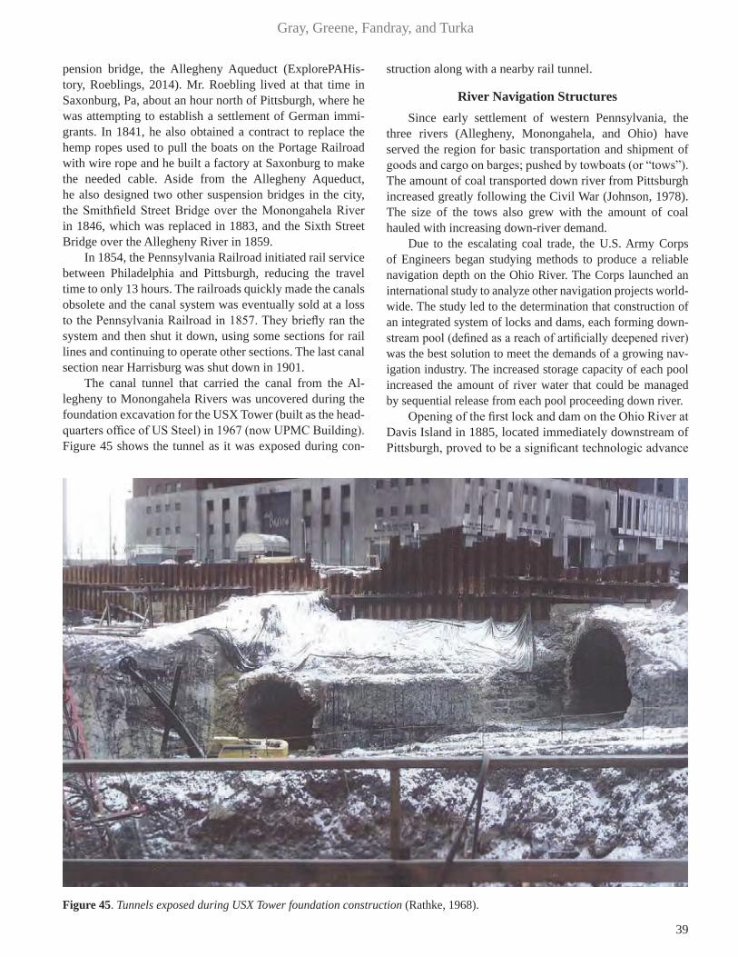
39
Gray, Greene, Fandray, and Turka
pension bridge, the Allegheny Aqueduct (ExplorePAHis-tory, Roeblings, 2014). Mr. Roebling lived at that time in Saxonburg, Pa, about an hour north of Pittsburgh, where he was attempting to establish a settlement of German immi-grants. In 1841, he also obtained a contract to replace the hemp ropes used to pull the boats on the Portage Railroad with wire rope and he built a factory at Saxonburg to make the needed cable. Aside from the Allegheny Aqueduct, he also designed two other suspension bridges in the city, the Smithfield Street Bridge over the Monongahela River in 1846, which was replaced in 1883, and the Sixth Street Bridge over the Allegheny River in 1859.
In 1854, the Pennsylvania Railroad initiated rail service between Philadelphia and Pittsburgh, reducing the travel time to only 13 hours. The railroads quickly made the canals obsolete and the canal system was eventually sold at a loss to the Pennsylvania Railroad in 1857. They briefly ran the system and then shut it down, using some sections for rail lines and continuing to operate other sections. The last canal section near Harrisburg was shut down in 1901.
The canal tunnel that carried the canal from the Al-legheny to Monongahela Rivers was uncovered during the foundation excavation for the USX Tower (built as the head-quarters office of US Steel) in 1967 (now UPMC Building). Figure 45 shows the tunnel as it was exposed during con-
struction along with a nearby rail tunnel.
River Navigation Structures Since early settlement of western Pennsylvania, the
three rivers (Allegheny, Monongahela, and Ohio) have served the region for basic transportation and shipment of goods and cargo on barges; pushed by towboats (or “tows”). The amount of coal transported down river from Pittsburgh increased greatly following the Civil War (Johnson, 1978). The size of the tows also grew with the amount of coal hauled with increasing down-river demand.
Due to the escalating coal trade, the U.S. Army Corps of Engineers began studying methods to produce a reliable navigation depth on the Ohio River. The Corps launched an international study to analyze other navigation projects world-wide. The study led to the determination that construction of an integrated system of locks and dams, each forming down-stream pool (defined as a reach of artificially deepened river) was the best solution to meet the demands of a growing nav-igation industry. The increased storage capacity of each pool increased the amount of river water that could be managed by sequential release from each pool proceeding down river.
Opening of the first lock and dam on the Ohio River at Davis Island in 1885, located immediately downstream of Pittsburgh, proved to be a significant technologic advance
Figure 45. Tunnels exposed during USX Tower foundation construction (Rathke, 1968).

40
Geology of Pittsburgh
Figure 46. Location of Locks and Dams on Pittsburgh’s Three Rivers (Figure courtesy of the Port of Pittsburgh Commission).

41
Gray, Greene, Fandray, and Turka
for the civil engineering profession at large. At Davis Is-land Lock and Dam, the wooden timber wicket dam was almost 1900 feet long and the dimension-stone masonry lock, 600-feet long and 110-feet wide, was the world’s largest river navigation structure at that time. Even then the stone-masonry lock at Davis Island was wider than the reinforced concrete locks built in 1914 at the Panama Ca-nal (Johnson, 1978).
In 1910, the Rivers and Harbors Act was passed by Congress, providing for the systematic construction of a system of locks and dams along the Ohio River. The project produced 51 wooden wicket dams and typical lock cham-bers of 600-feet long by 110-feet wide along the length of the river starting at Pittsburgh. Wicket dams were composed of moveable slab sections that were hinged at the bottom and held upright by adjustable props. Wicket dams in the Pittsburgh region were the earliest to be replaced by mass concrete dams.
Taken together, the systems of locks and dams on the three rivers of the Pittsburgh region have been described as “rivers that are highways.” Even today, they are the most ef-ficient and cost-effective means to move bulk commodities such as coal, and construction aggregates. Throughout the late 19th and early 20th centuries, the Monongahela River has carried a greater tonnage than any other inland river in America (Johnson, 1978). In comparison with the mighty Ohio and Mississippi Rivers, the Monongahela River was called the “Little Giant” because of the tonnage it transport-ed annually. Moving coal to steel mills in the western Penn-
sylvania towns upstream and downstream of Pittsburgh was of great importance, especially to the war effort in the late 1930s and early 1940s.
During the 1940s, a shift from steam-propelled to die-sel powered towboats allowed for larger tows on the river. However, this meant that tows had to be disassembled in or-der to lock all the barges through in multiple lockages, then reassembled before continuing. This functional inconve-nience created backed up river traffic and increased expens-es for the river tow boat industry. Even as modernization of locks in the lower Ohio River was initiated in the 1950s to handle the larger tows, the locks in the Pittsburgh region remained unchanged. In the upper Ohio River, nearest Pitts-burgh, each river navigation dam, being of a gated type or a simple concrete weir, has two parallel, adjoining locks; one 600-feet by 110-feet main chamber and a 360-feet long by 56-feet wide auxiliary chamber.
The Pittsburgh District Corps of Engineers currently op-erates and maintains 23 locks and dams on the three rivers (See Figure 46). This represents the largest number of nav-igation projects in any district of the Corps and it system-atically provides a 9-foot minimum depth navigation pool depth. In the 1990s a new lock and dam project was built on the Monongahela River south of Pittsburgh. The project was Grays Landing Locks and Dam, and involved tradition-al cofferdam construction. Steel sheet piles, driven to rock were used to form a series of interconnecting coffer cells. Once completed, the inner cofferdam area was pumped dry. Excavation of alluvial sediments was carried down to “top of
Figure 47. Map of Pittsburgh Railroads in 1855 (Pennsylvania Railroad, 1948).

42
Geology of Pittsburgh
bedrock.” At these variable depths, additional rock removal was continued in order to establish a foundation within com-petent bedrock. Once the final excavation was performed concrete was placed on the prepared rock foundation.
Recent construction on the Monongahela River in-volved the 2004 completion of a new gated dam on the Monongahela River, known as Braddock Locks and Dam, located 11 miles upstream of Pittsburgh. This project em-ployed innovative float-in construction techniques which involved two large precast segments set down on nearly 90 reinforced concrete drilled shafts embedded 16 feet into bedrock (Edwardo et al., 2002). In addition, construction is currently underway at Charleroi Locks and Dam, located 40 miles upstream of Pittsburgh, which will provide two new lock chambers 720-feet long by 84-feet wide.
Rail Systems The regional topography, consisting of major rivers,
steep hillsides and flat hilltops, has resulted in a unique transportation infrastructure in Pittsburgh that includes roads, tunnels, bridges, railroads, inclines, bike paths and stairways. Pittsburgh’s strategic location as a “Gateway to the West” resulted in use of the rivers as the primary trans-portation corridors, as they still are today.
When Pittsburgh was incorporated as a city in 1816, it was the major center for commerce in the west, and most travel from the east coast went through it. Around 1830, the commerce aspect of Pittsburgh’s economy was surpassed by its manufacturing base. To transport bulk goods, including coal, an economical and reliable mode of transportation was needed. The first rationally designed transportation network was the local railroad. This system was intended to trans-fer coal and goods to the industries within and surround-ing Pittsburgh. Topography initially restricted population growth to the city and railroad corridor expansion to the riv-er valleys. However, with the development of the abundant Pittsburgh Coal Seam, which resulted in newly established farm roads and communities in these mining areas, the rail-road lines began following the contours of the nearly flat lying Pittsburgh Coal Seam. Bridge structures developed as the railroads required “jumping” from one hillside to an-other to be in close contact with the mining areas. Like all other railroads of that time, they relied on horses or mules for power. Not much faster than wagons or canal boats, their main advantage was smooth-running rails.
The transition to the wide-spread interstate railroad sys-tem was a long battle. Pennsylvania had no urgent reason to invest in railroad technology until 1825, when the Erie Canal linked New York City’s ports to Midwest markets (Finch, 1925). Once the Erie Canal opened, shipping costs from New York to the Midwest dropped significantly, and the time it took to ship the goods was cut significantly. This greatly increased trade for New York City businesses while bypassing Pittsburgh and Philadelphia.
Shipping by water was still cheaper than by rail, but the railroads did have the advantage of traveling where riv-ers didn’t flow. A result was using trains and rivers togeth-er (Fleming, 1928). Started in 1834, the state-owned Main Line of Public Works used canal boats where possible on relatively level ground and a combination of gravity and stationary steam engines where necessary in the mountains (Baer, 1996). This patchwork of canals, railroads, and in-clined planes offered a 3 to 4 day journey from Philadelphia to Pittsburgh. But it was soon ended by the cheaper, all-pur-pose, all-weather railroads. The interstate railroads entered the area in the 1850s. In 1852, the Ohio and Pennsylvania Railroad began service between Cleveland and Allegheny City (present-day North Side), and in 1854, the Pennsylva-nia Railroad began service between Pittsburgh and Philadel-phia. An historical map of the Pittsburgh railroads is shown in Figure 47. A journey between Philadelphia and Pittsburgh now took only 13 hours. The Pennsylvania Railroad was the largest railroad in the world for much of its 121-year life-span, absorbing many other railroads as it grew. It hauled more freight and passengers than any other railroad in the world during that time. (Baer, 1996)
The railroad system in Pittsburgh flourished for many years. From the beginning of the industrial era through its collapse in the 1980s, Pittsburgh was always a key market for the nation’s largest and most important railroads. At one time, up to 22 railroads, including main lines and branch-es, entered Pittsburgh (Fleming, 1928). They comprised the lines of the Pennsylvania System, the New York Cen-tral Lines, the Baltimore and Ohio, the Buffalo, Rochester and Pittsburgh, the Pittsburgh, Bessemer and Lake Erie (the Carnegie Road), and the Wabash. However, with the coming of publicly funded highways and the availability of auto-mobiles after World War II, railroads began a long down-ward slide. Despite the near collapse of heavy industry in the northeast, Pittsburgh still remains an important link in the nation’s rail network. Current railroads in Pittsburgh in-clude: Norfolk Southern, CSX, Amtrak, Wheeling & Lake Erie and the Allegheny Valley Railroad.
Another rail system that once existed in Pittsburgh was the inter-city trolley car. It started in the late 1800s and ear-ly 1900s and followed both the farm roads lying at the ridge tops, the alignments of the railroad network, and many aban-doned railroad corridors. They became most popular in the 1940s and 1950s as an economical mass transit solution for the expanding Pittsburgh (See Figure 48). A fleet of more than 600 trolleys were in use in 1948 (Bennear, 1995). The demise of the trolley was due to the speed and flexibility of gasoline powered buses. By the early 1970s, the fleet had dwindled to 95 cars and 4 lines. By 1985 almost all trolley rails were over-lain by asphalt, with few cars and lines existing. Today, a light rail system in Pittsburgh known as the “T” has replaced rem-nants of the trolley lines. These lines run between downtown Pittsburgh and the South Hills suburbs. In town these lines
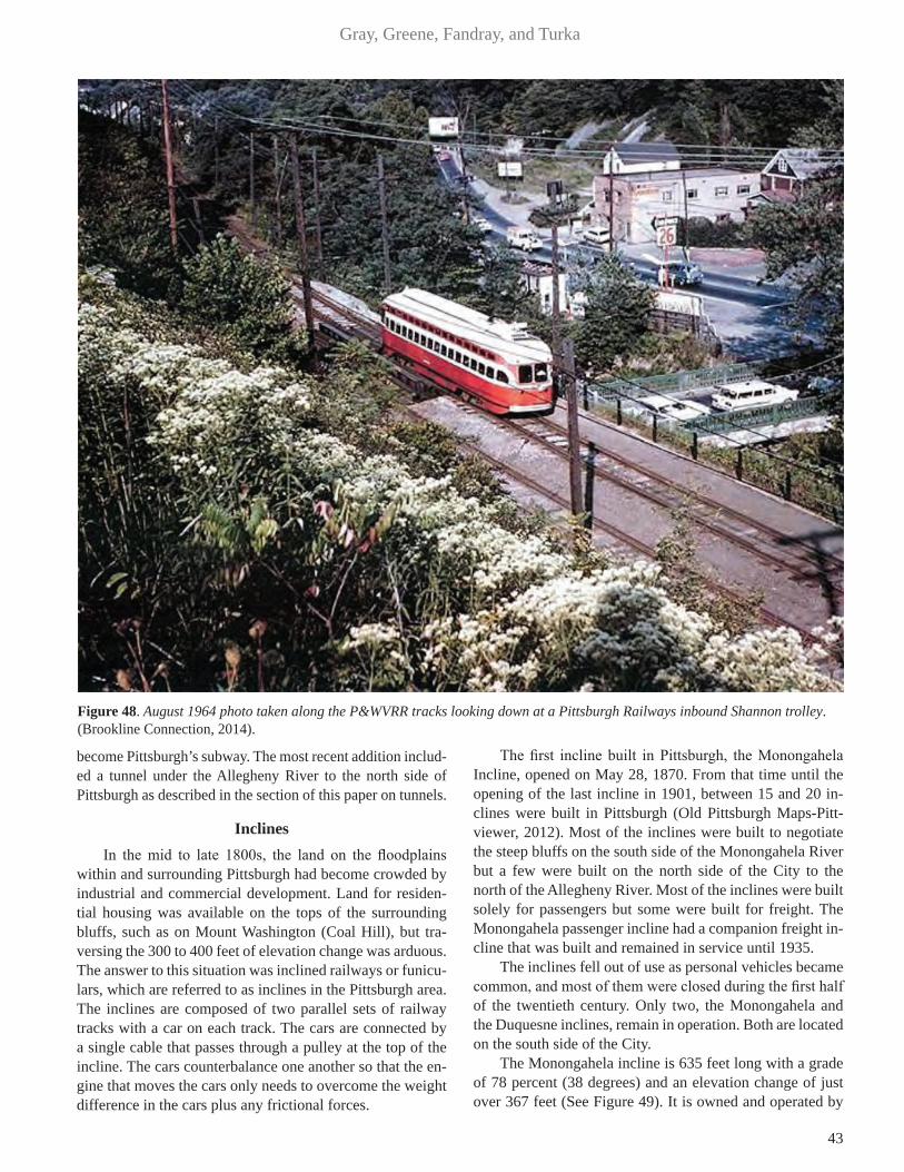
43
Gray, Greene, Fandray, and Turka
become Pittsburgh’s subway. The most recent addition includ-ed a tunnel under the Allegheny River to the north side of Pittsburgh as described in the section of this paper on tunnels.
InclinesIn the mid to late 1800s, the land on the floodplains
within and surrounding Pittsburgh had become crowded by industrial and commercial development. Land for residen-tial housing was available on the tops of the surrounding bluffs, such as on Mount Washington (Coal Hill), but tra-versing the 300 to 400 feet of elevation change was arduous. The answer to this situation was inclined railways or funicu-lars, which are referred to as inclines in the Pittsburgh area. The inclines are composed of two parallel sets of railway tracks with a car on each track. The cars are connected by a single cable that passes through a pulley at the top of the incline. The cars counterbalance one another so that the en-gine that moves the cars only needs to overcome the weight difference in the cars plus any frictional forces.
The first incline built in Pittsburgh, the Monongahela Incline, opened on May 28, 1870. From that time until the opening of the last incline in 1901, between 15 and 20 in-clines were built in Pittsburgh (Old Pittsburgh Maps-Pitt-viewer, 2012). Most of the inclines were built to negotiate the steep bluffs on the south side of the Monongahela River but a few were built on the north side of the City to the north of the Allegheny River. Most of the inclines were built solely for passengers but some were built for freight. The Monongahela passenger incline had a companion freight in-cline that was built and remained in service until 1935.
The inclines fell out of use as personal vehicles became common, and most of them were closed during the first half of the twentieth century. Only two, the Monongahela and the Duquesne inclines, remain in operation. Both are located on the south side of the City.
The Monongahela incline is 635 feet long with a grade of 78 percent (38 degrees) and an elevation change of just over 367 feet (See Figure 49). It is owned and operated by
Figure 48. August 1964 photo taken along the P&WVRR tracks looking down at a Pittsburgh Railways inbound Shannon trolley. (Brookline Connection, 2014).

44
Geology of Pittsburgh
the Port Authority of Allegheny County and has been in constant operation since it was constructed. It has under-gone major renovations and upgrades.
The Duquesne incline is located opposite the Point. It is 793 feet long with a grade of 58 percent (30 degrees) and an elevation change of 400 feet. The Society for the Preserva-tion of the Duquesne Heights Incline raised money in 1963 to save the incline. It still has the same Victorian cars with the original woodwork. The engines have been converted from steam to electric power.
Bridges (by Thomas Leech, P.E., Gannett Fleming, Inc.)In Pittsburgh, bridges are all around us. Allegheny
County, including the city of Pittsburgh, has over 2,000 bridges of varying types, materials and sizes. Some bridges are quite new; others are quite old. Some are distinct and magnificent; others are quite ordinary.
“There is something intensely dramatic and fanciful in
the appeal of the bridge to all classes of people, under all conditions of nature. All traffic converges and concentrates on the bridges. They become a daily necessity and a famil-iar benefactor, giving convenient passage over some natural obstruction.”
(Kidney, 1999). Many bridges have seen a service life well over 100
years. Many replace one or even two earlier bridges at the same site. Each bridge records in its composition, in essence, a genetic code of its era of construction. This genetic code records both an engineering and architectural imprint of the age that it was built. All of these bridges, have been distinct-ly shaped by both the geography and geology of the area.
River CrossingsThe Monongahela River (i.e. river with sliding banks –
Delaware Native American) and the Allegheny River (i.e. riv-er of the Alligewi - Delaware Native American) form the Ohio River (i.e. “the good river” - Seneca Native American) at the
Figure 49. Monongahela Incline.

45
Gray, Greene, Fandray, and Turka
“Point” in Pittsburgh (Bright, 2004). At present there are 30 river crossings in the city of Pittsburgh and another 29 riv-er crossings in other communities within Allegheny County. Pittsburgh rivals other “bridge” cities of the world, including Paris with its 38 river crossings within the city proper, and Venice with its 409 bridges spanning 150 canals, but with only 4 bridges which cross the Grand Canal (Cridlebaugh, 2014).
As Pittsburgh emerged as a city in the early 1800s, the rivers were a formidable barrier to transportation. The first river crossings relied on geographic features such as fording the rivers by way of sand bar islands. These cross-ings were later replaced with ferry service near the fords. The locations of fords and subsequent ferries later became sites of the first river bridges constructed in Pittsburgh. The first established river crossing within Pittsburgh was the site of the present Smithfield Street Bridge over the Monongahela River, initially a river ford, which later was replaced with the nearby Jones Ferry (Cridlebaugh, 2014). The ferry service was subsequently replaced by a wood-en covered bridge in 1818 that later was destroyed by the great fire of 1845 (Lorant, 1975). The present Smithfield Street Bridge, a third generation replacement bridge, is an elegant lenticular steel truss and an ASCE Civil Engineer-ing Landmark. The present bridge was constructed in 1881 and is recognized as the oldest standing bridge in the city (Figure 50). The second established ferry, Robinson’s ferry, connected the North Side (previously Allegheny City) with downtown Pittsburgh, in close proximity to the present 6th Street Bridge. In 1819 the first span across the Allegheny River was a wooden covered bridge constructed at this site. It was ultimately replaced by the present third generation Sixth Street Bridge, a self-anchored suspension span, one
of the 1928 Three Sisters Bridges, which are recognized as the only surviving eye bar chain suspension bridges in America (Figure 51). Quickly, transportation routes de-veloped around these ferry crossings and the rivers of Pittsburgh now contain a myriad of bridges with unique structural form and complexity, all of which is a testament to Pittsburgh’s prominence as a historic center of Civil En-gineering practice. The main spans of the river crossings range from 400 feet to 800 feet, consistent with navigation requirements, and typically the present 59 river crossings comprise variant steel superstructures, egalitarian trusses and plate girder bridges and visually appealing tied arch and suspension bridges.
As Pittsburgh grew to become an industrial power, the surface transportation routes shifted from town centric to bypass or through routes as the transportation routes ulti-mately shifted to interstate corridors, presently converging at the “Point” in Pittsburgh. Three generations of bridges have spanned the Monongahela River at the “Point,” includ-ing the 1875 Point suspension bridge, the 1927 steel cantile-ver truss and the current 1959 Fort Pitt (I-279 / I-376) steel double deck tied arch. Three generations of bridges also have spanned the Allegheny River at the “Point,” including the 1874 Union, wooden covered bridge, the 1915 two span steel trussed Manchester Bridge, and the current 1969 Fort Duquesne (I-279) steel double deck tied arch.
The transportation networks within Pittsburgh and the surrounding communities in Allegheny County required an array of valley crossings that are supported by nearly 2,000 bridge structures. Many of the valleys are quite steep sided and many interesting structures were designed with heights as much as 200 feet above the valley floors and spans reach-
Figure 50. Smithfield Street Bridge in downtown Pittsburgh: HAER collection (Cridlebaugh, 2014).
Figure 51. Sixth Street Bridge in downtown Pittsburgh: HAER collection (Cridlebaugh, 2014).
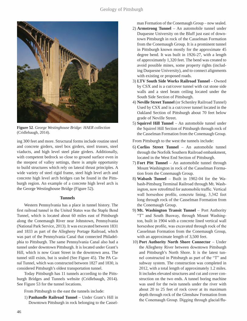
46
Geology of Pittsburgh
ing 300 feet and more. Structural forms include routine steel and concrete girders, steel box girders, steel trusses, steel viaducts, and high level steel plate girders. Additionally, with competent bedrock so close to ground surface even in the steepest of valley settings, there is ample opportunity to build structures which rely on lateral thrust principles. A wide variety of steel rigid frame, steel high level arch and concrete high level arch bridges can be found in the Pitts-burgh region. An example of a concrete high level arch is the George Westinghouse Bridge (Figure 52).
TunnelsWestern Pennsylvania has a place in tunnel history. The
first railroad tunnel in the United States was the Staple Bend Tunnel, which is located about 60 miles east of Pittsburgh along the Conemaugh River near Johnstown, Pennsylvania (National Park Service, 2013). It was excavated between 1831 and 1833 as part of the Allegheny Portage Railroad, which was part of the Pennsylvania Canal that connected Philadel-phia to Pittsburgh. The same Pennsylvania Canal also had a tunnel under downtown Pittsburgh. It is located under Grant’s Hill, which is now Grant Street in the downtown area. The tunnel still exists, but is sealed (See Figure 45). The PA Ca-nal Tunnel, which was constructed between 1827 and 1830, is considered Pittsburgh’s oldest transportation tunnel.
Today Pittsburgh has 11 tunnels according to the Pitts-burgh Bridges and Tunnels website (Cridlebaugh, 2014). See Figure 53 for the tunnel locations.
From Pittsburgh to the east the tunnels include: 1) Panhandle Railroad Tunnel – Under Grant’s Hill in
Downtown Pittsburgh in rock belonging to the Cassel-
man Formation of the Conemaugh Group – now sealed.2) Armstrong Tunnel – An automobile tunnel under
Duquesne University on the Bluff just east of down-town Pittsburgh in rock of the Casselman Formation from the Conemaugh Group. It is a prominent tunnel in Pittsburgh known mostly for the approximate 45 degree bend. It was built in 1926-27, with a length of approximately 1,320 feet. The bend was created to avoid possible mines, some property rights (includ-ing Duquesne University), and to connect alignments with existing or proposed roads.
3) LTV South Side Works Railroad Tunnel – Owned by CSX and is a cut/cover tunnel with cut stone side walls and a steel beam ceiling located under the South Side Section of Pittsburgh.
4) Neville Street Tunnel (or Schenley Railroad Tunnel) Used by CSX and is a cut/cover tunnel located in the Oakland Section of Pittsburgh about 70 feet below grade of Neville Street.
5) Squirrel Hill Tunnel – An automobile tunnel under the Squirrel Hill Section of Pittsburgh through rock of the Casselman Formation from the Conemaugh Group.
From Pittsburgh to the west the tunnels include: 6) Corliss Street Tunnel – An automobile tunnel
through the Norfolk Southern Railroad embankment, located in the West End Section of Pittsburgh.
7) Fort Pitt Tunnel – An automobile tunnel through Mount Washington in rock of the Casselman Forma-tion from the Conemaugh Group.
8) Wabash Tunnel – Built in 1902-04 for the Wa-bash-Pittsburg Terminal Railroad through Mt. Wash-ington, now retrofitted for automobile traffic. Vertical wall horseshoe profile, concrete lining, 3,342 feet long through rock of the Casselman Formation from the Conemaugh Group.
9) Mt. Washington Transit Tunnel – Port Authority “T” and South Busway, through Mount Washing-ton, built in 1904 with a concrete lined vertical wall horseshoe profile, was excavated through rock of the Casselman Formation from the Conemaugh Group, with an approximate length of 3,500 feet.
10) Port Authority North Shore Connector – Under the Allegheny River between downtown Pittsburgh and Pittsburgh’s North Shore. It is the latest tun-nel constructed in Pittsburgh as part of the “T” and subway system. The construction was completed in 2012, with a total length of approximately 1.2 miles. It includes elevated structures and cut and cover con-struction on the two ends. A tunnel boring machine was used for the twin tunnels under the river with about 20 to 25 feet of rock cover at its maximum depth through rock of the Glenshaw Formation from the Conemaugh Group. Digging through glacial/flu-
Figure 52. George Westinghouse Bridge: HAER collection (Cridlebaugh, 2014).

47
Gray, Greene, Fandray, and Turka
vial gravel and rock, the working face was stabilized with a pressurized bentonite-water slurry. The exca-vated material was transported by the slurry through pipes back to a separation plant above ground where sand and gravel were separated from the slurry.
11) Liberty Tunnel – An automobile tunnel through Mount Washington in rock of the Casselman For-mation from the Conemaugh Group.
Much of the heaviest automobile traffic is associated with the tunnels, which is ironic because these structures were supposed to reduce driving time. Notable tunnels of the area include the Liberty Tunnel, which connects the south suburbs to the city and the two interstate I-376 high-way tunnels (Squirrel Hill and Fort Pitt), which connect the east and west suburbs to the city.
Mount Washington is nearly 400 feet high along the length of Pittsburgh’s downtown area, and posed a barrier to the development of the South Hills. In order to provide access, the Liberty Tunnel, which is considered to be the first modern automobile tunnel in the United States, was excavat-ed through Mount Washington. It consists of twin concrete lined tunnels in a vertical wall horseshoe profile. The coun-ty began construction of the tunnel in the winter of 1919, and the excavation was completed in July 1922. The rock excavated was mostly “green” and “red” claystone and soft laminated sandstone of the Casselman Formation from the Conemaugh Group, with a minor amount of more competent “blue” sandstone (Public Works, 1921). Most of the excava-tion was considered treacherous due to the poor condition of the soft rock. The tunnels are 5,889 feet long, 28.6 feet wide and 20.8 feet clearance in the arch portion of the tun-
Figure 53. Tunnel Locations in Pittsburgh (Map courtesy of John Harper, PA Geological Survey).
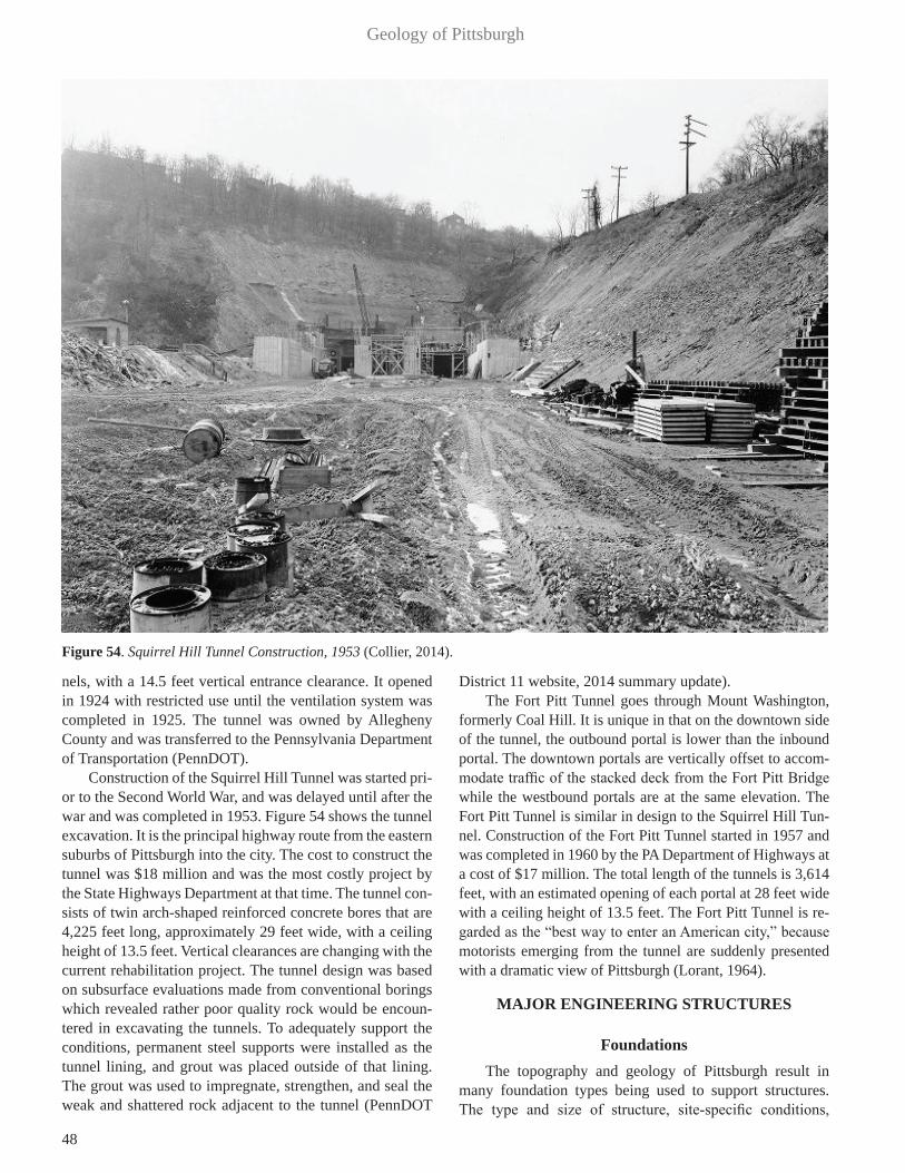
48
Geology of Pittsburgh
nels, with a 14.5 feet vertical entrance clearance. It opened in 1924 with restricted use until the ventilation system was completed in 1925. The tunnel was owned by Allegheny County and was transferred to the Pennsylvania Department of Transportation (PennDOT).
Construction of the Squirrel Hill Tunnel was started pri-or to the Second World War, and was delayed until after the war and was completed in 1953. Figure 54 shows the tunnel excavation. It is the principal highway route from the eastern suburbs of Pittsburgh into the city. The cost to construct the tunnel was $18 million and was the most costly project by the State Highways Department at that time. The tunnel con-sists of twin arch-shaped reinforced concrete bores that are 4,225 feet long, approximately 29 feet wide, with a ceiling height of 13.5 feet. Vertical clearances are changing with the current rehabilitation project. The tunnel design was based on subsurface evaluations made from conventional borings which revealed rather poor quality rock would be encoun-tered in excavating the tunnels. To adequately support the conditions, permanent steel supports were installed as the tunnel lining, and grout was placed outside of that lining. The grout was used to impregnate, strengthen, and seal the weak and shattered rock adjacent to the tunnel (PennDOT
District 11 website, 2014 summary update).The Fort Pitt Tunnel goes through Mount Washington,
formerly Coal Hill. It is unique in that on the downtown side of the tunnel, the outbound portal is lower than the inbound portal. The downtown portals are vertically offset to accom-modate traffic of the stacked deck from the Fort Pitt Bridge while the westbound portals are at the same elevation. The Fort Pitt Tunnel is similar in design to the Squirrel Hill Tun-nel. Construction of the Fort Pitt Tunnel started in 1957 and was completed in 1960 by the PA Department of Highways at a cost of $17 million. The total length of the tunnels is 3,614 feet, with an estimated opening of each portal at 28 feet wide with a ceiling height of 13.5 feet. The Fort Pitt Tunnel is re-garded as the “best way to enter an American city,” because motorists emerging from the tunnel are suddenly presented with a dramatic view of Pittsburgh (Lorant, 1964).
MAJOR ENGINEERING STRUCTURES
FoundationsThe topography and geology of Pittsburgh result in
many foundation types being used to support structures. The type and size of structure, site-specific conditions,
Figure 54. Squirrel Hill Tunnel Construction, 1953 (Collier, 2014).
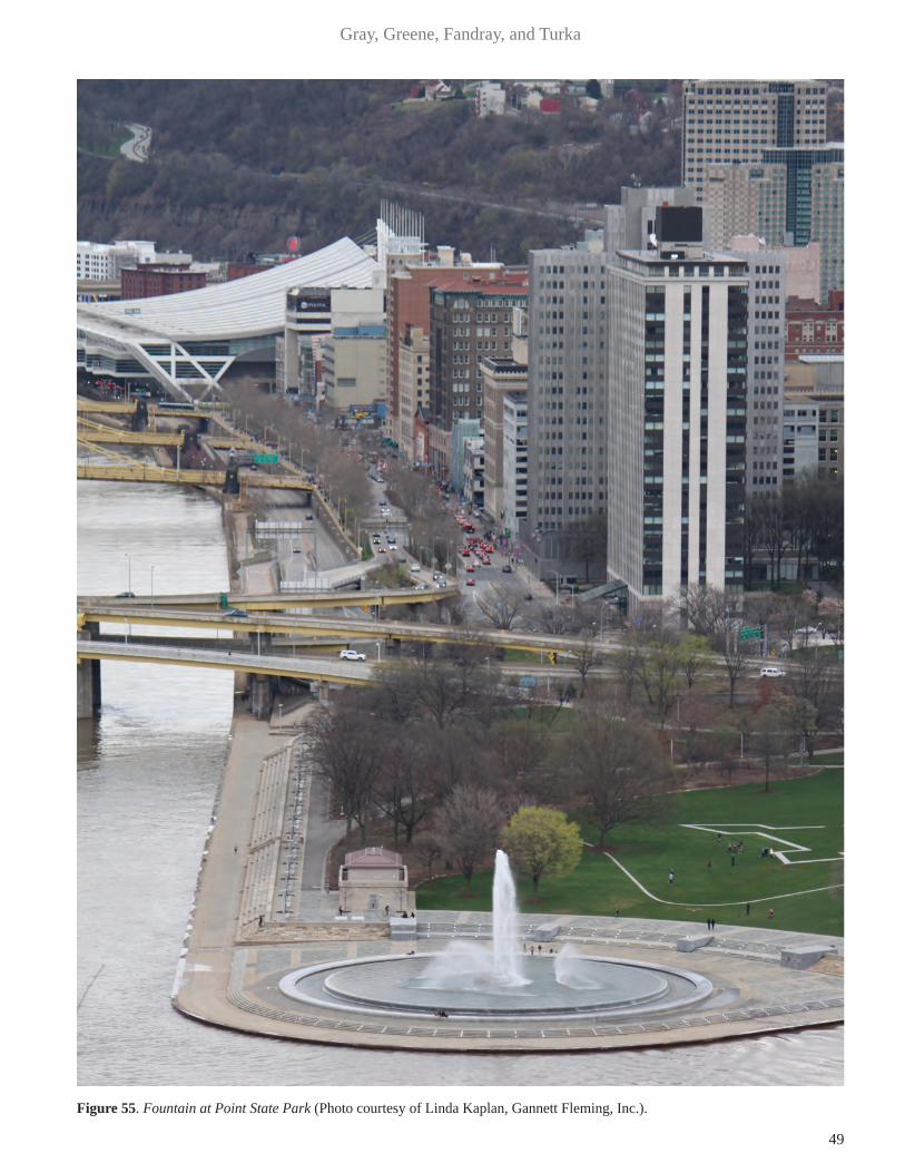
49
Gray, Greene, Fandray, and Turka
Figure 55. Fountain at Point State Park (Photo courtesy of Linda Kaplan, Gannett Fleming, Inc.).

50
Geology of Pittsburgh
local practice, and the designer’s preference may influ-ence the type of foundation selected as much as geology. There are areas where special foundation problems such as soft soils, subsidence due to mining, expansive shale and landslides exist. In general, residual soils throughout Pitts-burgh are adequate to support the foundations of homes and light-commercial buildings. For heavy foundation loads, rock normally provides adequate support, except where deeply weathered. Some local claystones and shales slake or dry out when exposed to the atmosphere and require im-mediate covering to avoid further deterioration and addi-tional excavation. Pile driving can shatter these shales and claystones, and piles may have to be re-driven several times before deeper competent rock is encountered. A foundation designer must consider both surface and underground min-ing as potential sites for differential settlement, subsidence, slope instability, mine and refuse fires, acidic soil, rock and water. Shales should be considered a foundation problem until their potential for heaving is determined.
The alluvial soils in the Monongahela River drainage are generally soft and large structures normally require foundations extending to or into rock to avoid excessive settlements. The glacial gravels in the Allegheny and Ohio River Valleys are generally dense and can carry significant foundation loads with only minor settlement. These dense glacial sand and gravel deposits occur in downtown Pitts-burgh. In the area between the rivers, the contours of the top of rock rise away from the rivers, and the sand and gravel deposit ends around Smithfield Street between Fourth and Sixth Avenues, as shown in Figure 20 (Van Tuyl, 1951).
A variety of foundation types have been used to support buildings on the dense glacial gravel in downtown Pitts-burgh. They include spread footings, a mat foundation and friction piles. However, the three Gateway office buildings adjacent to Point State Park are an anomaly in that they are supported on H-Piles driven through the glacial gravels to rock. Where the dense glacial gravel is not present, east of Smithfield Street, buildings are generally supported by spread footings or drilled piers bearing on rock.
In recent years, larger scale projects including the Brad-dock Dam, the Consol Hockey Arena, the U.P.M.C. East hospital and the Pennsylvania Turnpike Bridge crossing the Allegheny River have been constructed. The size of the projects justified the use of Osterberg Load Cell Tests to de-termine the bearing and side shear properties for optimizing the design of drilled piers in rock.
Some sites and projects of interest are described as follows:
Point State ParkPoint State Park comprises 36 acres at the confluence
of the Allegheny and Monongahela Rivers. The park recog-nizes Pittsburgh’s past and present, including the strategic importance and historic role the Pittsburgh Point had in the
development of the United States. The Ohio River afford-ed great influence over more than 200,000 square miles of undeveloped territory downstream of the Point. In the early 1800s swarms of settlers moved through Pittsburgh on their way west. Traffic down the Ohio River reached a volume of more than 1,000 boats a year leaving Pittsburgh, with 20,000 people and more than 12,000 head of livestock, wag-ons, provisions and household goods.
Following capture of the French Fort Duquesne in 1758, the English proceeded to construct the most impressive fort on the American Frontier, Fort Pitt. Point State Park includes parts of the Fort Pitt Bastions, and the original Fort Pitt Block House Built in 1764. The Fort Pitt Blockhouse is the oldest architectural landmark in Pittsburgh and is the nation’s only authenticated pre-Revolutionary War structure west of the Appalachian Mountains (Pennsylvania Department of Natu-ral Resources, 2015). Much of the structure is intact, includ-ing the stone foundation, brick, and timber elements that are largely original to its 1764 construction. In addition, the Park contains a fountain, dedicated in 1974, said to be the largest in the United States, which propels water upwards approxi-mately 200 feet (Figure 55). The 73,000 gallons of water in the closed-loop system are drawn from glacial gravels 50 feet beneath the Point (Compressed Air Magazine, 1974).
U.S. Steel BuildingThe U.S. Steel Building, also known as the U.S. Steel
Tower, is a 64 story (841.0 feet high) skyscraper located on Grant Street in downtown Pittsburgh. Construction started in March 1967, and was completed September 30, 1971. At 841 feet, the U.S. Steel Building was the tallest building be-tween New York and Chicago until 1987. The building site occupies a portion of Grant’s Hill, a prominent feature in the early history of Pittsburgh. In September 1758, Major James Grant led an advance column of 800 men of British Gener-al John Forbes’ army against Fort Duquesne. The British force was repelled on a hill east of the Point with 342 men killed, wounded or captured. Major Grant was captured, but paroled soon after. When General Forbes occupied the aban-doned Fort Duquesne on November 25, 1758, the nearby site of the battle was named Grant’s Hill (Pittsburgh, 2008).
Grant’s Hill was leveled on several occasions, a total of approximately twenty feet. Excavation for the U.S. Steel Building foundation excavation extended into rock and the final foundation for the structure was placed on bedrock.
The excavation uncovered two tunnels which had been constructed through Grant’s Hill (Figure 45). One was an 810 foot Pennsylvania Canal tunnel constructed in 1834. The second was the Pittsburgh and Steubenville Exten-sion Railroad tunnel. This railroad was a link between the Pennsylvania Railroad’s western terminus and the eastern terminus of the Steubenville Railroad Company. When this rail link opened in 1865, it extended the Pennsylvania Rail-road’s trade and transportation network into Ohio, as far

51
Gray, Greene, Fandray, and Turka
as Columbus. This tunnel was built using cut-and-cover. A trench, approximately thirty-five feet wide, was excavated from the ground surface to elevation 780 feet and the tun-nel was constructed within the trench, then the excavation was backfilled. The average height of the tunnel side walls was eighteen feet. A five-course brick arch was supported on the walls. The railroad tunnel was rehabilitated to serve as an underground right-of-way and station area (Midtown Station) for the Light Rail Transit Subway (HAER, 1985).
During the 1965-67 construction of the U.S. Steel Building, a new single track tunnel, measuring 409 feet long and 17.4 feet wide, was built within the subterranean levels of the building as part of Pittsburgh’s Light Rail Subway. The support systems for the tunnel and the building were designed to be independent of each other, so that train vi-brations would not disturb the building’s structural integrity and the weight of the building would not bear on the tunnel. The U.S. Steel Building tunnel begins 1,029.6 feet from the south portal, is rectilinear in design, and has two safety bays measuring one foot deep and approximately five feet wide.
The U.S. Steel Building made history by being the first to use liquid-filled fireproofed columns. U.S. Steel delib-erately placed the massive steel columns on the exterior of the building to showcase a new product called Cor-ten steel. Cor-ten resists the corrosive effects of rain, snow, ice, fog, and other meteorological conditions by forming a coating of dark brown oxidation over the metal, which inhibits deeper penetration and doesn’t need painting and costly rust-pre-vention maintenance over the years. The initial weathering of the material resulted in a discoloration of the surrounding city sidewalks, as well as other nearby buildings. A clean-up effort was conducted by the corporation once weathering was complete to undo this damage, but the sidewalks still have a decidedly rusty tinge. The Cor-Ten steel for the build-ing was made at the former U.S. Steel Homestead Works. The building contains over 44,000 tons of structural steel (U.S. Steel Tower, 2015).
SubwayPittsburgh’s subway system was constructed in the early
1980s. The project’s goal was to upgrade the city’s streetcar lines into a modern 10.5 mile long light rail transit (LRT) system with two connecting exclusive bus roadways. Most of the rail system is in the suburbs south of the Monongahe-la River and is almost entirely on nonexclusive right of way at grade. After crossing the river into downtown Pittsburgh the transit line dives into a 1.1 mile long Y-shaped subway layout consisting of new and renovated two-track tunnels. This portion of the project accounted for only about one sev-enth of the project’s $480 million cost.
The Port Authority of Allegheny County held the cost down by purchasing an old railroad bridge across the riv-er along with a tunnel that ran north across the city. New subway work, all cut-and-cover, included building the large
Midtown Station at the intersection of the subway Y and a line running east through Wood Street Station and terminat-ing at Gateway Center.
One of the most challenging sections was the Wood Street Station, extending out below storage vaults under the sidewalks to adjacent building lines. The Hayward Baker Co. conducted the work and it represented the largest chem-ical grouting job ever performed in the U.S. to that date (Karol, 2003). This $2.5 million job was a showcase for nondestructive testing. Work was monitored by the cross-hole seismic method. Hayward Baker injected a 13,000 sq-ft area beneath Sixth Avenue with 1 million gallons of chemi-cal grout, turning the sand and gravel into a solid matrix that was excavated without danger while shoring up six adjacent buildings. The grout consisted of a proprietary formulation of sodium silicate and a number of reactants. The subway was completed in late 1984.
The North Shore Connector is a light-rail extension that opened in 2012. The connector extends the Pittsburgh Light Rail system from its previous terminus at Gateway Center Station in the Central Business District to the new North Side Station and Allegheny Station on the North Shore by way of a tunnel under the Allegheny River.
The North Shore neighborhood of Pittsburgh evolved from a “sea of asphalt” in the 1990s to a bustling extension of the central business district reflecting approximately one billion dollars of investment and construction in the first decade of the 2000s (Schmitz, 2010; O’Neill, 2008). The North Shore Connector links Pittsburgh’s previously exist-ing light rail network to the new businesses and attractions of the North Shore, serving commuters, visitors, and sports event attendees alike (Fontaine, 2012).
The North Side Station serves PNC Park (1.75 million annual baseball fans) and the Community College of Allegh-eny County (7,200 students). The Allegheny Station serves residents in Allegheny West and Manchester, as well as vis-itors to Heinz Field (500,000 annual Steeler fans, exclud-ing concerts), the Carnegie Science Center (700,000 annual visitors), Children’s Museum of Pittsburgh (250,000 annual visitors) and the Rivers Casino (Port Authority, North Shore Connector, 2015). During weekdays, downtown-destined vehicle commuters utilize the Connector by parking in one of the many North Shore parking facilities and completing their commute on the Connector (Shumway, 2012). The North Shore lacks the parking capacity to serve additional sports fans, so that the North Shore Connector helps alleviate the congestion by making it easier for fans to park Down-town and travel to the North Shore Stadium (Lord, 2010).
The new subway section was constructed by cut and cover from the Gateway Center, 400 feet to the Stanwix Street receiving pit. The subway construction consisted of twin bored tunnels, 22 feet in diameter from the Stanwix Street receiving pit to the West General Robinson launch pit, a length of 2,240 feet including 875 feet beneath the Al-

52
Geology of Pittsburgh
legheny River. From the General Robinson Street launch pit, the subway was constructed by cut and cover for a distance of 1,200 feet. From this north portal the line is elevated for 2,000 feet to Allegheny Station. Figure 56 shows a map of the tunnel alignment and Pittsburgh’s subway stations.
The top of the twin tunnels lies 20-25 feet below the riv-er bed. The German tunnel boring machine (TBM) assem-bly began in November 2007. The TBM, measuring 200 feet long and weighing 500 tons, was lowered into a 55-foot-deep launch pit excavated near the intersection of West Gen-eral Robinson Street and Mazeroski Way near PNC Park. The TBM began work in January 2008 (Wargo et al., 2009).
In July 10, 2008, the TBM holed through into the re-ceiving pit at Stanwix Street near Penn Avenue downtown. The machine was hoisted by crane, turned around and be-gan digging the second parallel tunnel September 3, arriving back at the North Side launch pit January 15, 2009. Com-pleting the second tunnel in 4.5 months showed the bene-fit from experiences gained; the second tunnel was a full month faster than the first.
The laser-guided, slurry pressure balanced, mixed shield
TBM had a 22-foot diameter rotating head (typically 1 RPM), featuring 17-inch cutters, driven by electric motors. Digging through glacial/fluvial gravel and rock, the working face was stabilized with a pressurized bentonite-water slurry; the ex-cavated material was transported by the clay slurry through pipes back to a separation plant above ground. Excavated sand and gravel were separated from the slurry, allowing the slurry to be reused and the other materials to be reserved for future use elsewhere. The TBM’s cutting face had a diameter that was one inch larger than the rest of the machine. This small annulus reduced side friction of the TBM shield, enabling it to move more easily, assisting in steering the machine, and thus controlling alignment (Wargo et al., 2009). The TBM was generally operated in two 12-hour shifts, five days a week, averaging 34 feet per day. As the front of the TBM cut, a steel shield in the trailing section held the cavity open and 4-foot-wide, precast concrete segments were bolted together to form the tunnel liner (seven segments complete the circumference of a given ring). The TBM then used hydraulic legs to push off the placed concrete rings as it moved forward. The complete mining assembly measured approximately 150 feet from the
Figure 56. Map of the North Shore Connector Tunnel and subway stations.
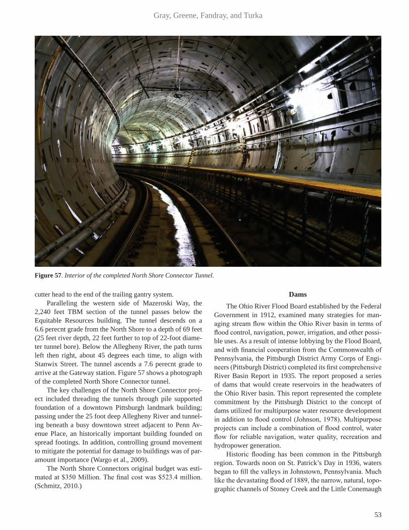
53
Gray, Greene, Fandray, and Turka
cutter head to the end of the trailing gantry system. Paralleling the western side of Mazeroski Way, the
2,240 feet TBM section of the tunnel passes below the Equitable Resources building. The tunnel descends on a 6.6 perecnt grade from the North Shore to a depth of 69 feet (25 feet river depth, 22 feet further to top of 22-foot diame-ter tunnel bore). Below the Allegheny River, the path turns left then right, about 45 degrees each time, to align with Stanwix Street. The tunnel ascends a 7.6 perecnt grade to arrive at the Gateway station. Figure 57 shows a photograph of the completed North Shore Connector tunnel.
The key challenges of the North Shore Connector proj-ect included threading the tunnels through pile supported foundation of a downtown Pittsburgh landmark building; passing under the 25 foot deep Allegheny River and tunnel-ing beneath a busy downtown street adjacent to Penn Av-enue Place, an historically important building founded on spread footings. In addition, controlling ground movement to mitigate the potential for damage to buildings was of par-amount importance (Wargo et al., 2009).
The North Shore Connectors original budget was esti-mated at $350 Million. The final cost was $523.4 million. (Schmitz, 2010.)
Dams The Ohio River Flood Board established by the Federal
Government in 1912, examined many strategies for man-aging stream flow within the Ohio River basin in terms of flood control, navigation, power, irrigation, and other possi-ble uses. As a result of intense lobbying by the Flood Board, and with financial cooperation from the Commonwealth of Pennsylvania, the Pittsburgh District Army Corps of Engi-neers (Pittsburgh District) completed its first comprehensive River Basin Report in 1935. The report proposed a series of dams that would create reservoirs in the headwaters of the Ohio River basin. This report represented the complete commitment by the Pittsburgh District to the concept of dams utilized for multipurpose water resource development in addition to flood control (Johnson, 1978). Multipurpose projects can include a combination of flood control, water flow for reliable navigation, water quality, recreation and hydropower generation.
Historic flooding has been common in the Pittsburgh region. Towards noon on St. Patrick’s Day in 1936, waters began to fill the valleys in Johnstown, Pennsylvania. Much like the devastating flood of 1889, the narrow, natural, topo-graphic channels of Stoney Creek and the Little Conemaugh
Figure 57. Interior of the completed North Shore Connector Tunnel.
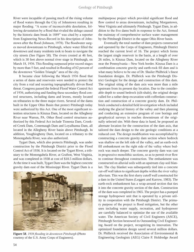
54
Geology of Pittsburgh
River were incapable of passing much of the rising volume of flood waters through the City of Johnstown resulting in major flooding. “A scene of inconceivable desolation, fol-lowing devastation by a flood that rivaled the deluge caused by the historic dam break in 1889” was cited by a reporter from Engineering News-Record in his description of John-stown after the flood (Johnson, 1978). The floodwater surg-es moved downstream to Pittsburgh, where water filled the downtown and many residents took to boats to navigate the city streets (See Figure 58). The rivers crested at 46 feet, which is 30 feet above normal river stage in Pittsburgh, on March 18, 1936. This flooding surpassed prior record stages by more than 5 feet, and resulted in flooding of 62 percent of the downtown “Golden Triangle” area of the city.
It became clear following the March 1936 flood that a series of dams and reservoirs were needed to protect the city from a real and recurring topographically driven flood threat. Congress passed the federal Flood Water Control Act of 1936, authorizing and funding these secondary flood con-trol structures, including dams and levees, mostly located on tributaries to the three major rivers. Several of the dams built in the Upper Ohio Basin that protect Pittsburgh today were authorized by this Act. One of the most significant re-tention structures is Kinzua Dam, located on the Allegheny River near Warren, PA. Other flood control structures au-thorized by this Federal Act include Tionesta Dam, Crook-ed Creek Dam, Conemaugh Dam and Loyalhanna Dam, all located in the Allegheny River basin above Pittsburgh. In addition, Youghiogheny Dam, located on a tributary to the Monongahela River, was also authorized.
Tygart Dam, which also protects Pittsburgh, was under construction by the Pittsburgh District prior to the Flood Control Act of 1936. It is located on the Tygart River, a trib-utary to the Monongahela River, at Grafton, West Virginia, and was completed in 1938 at cost of $18.5 million dollars. At the time it was built, Tygart Dam was the highest concrete gravity dam east of the Mississippi River. Tygart Dam is a
multipurpose project which provided significant flood and flow control to areas downstream, including Morgantown, West Virginia and ultimately Pittsburgh. Tygart Dam, in ad-dition to the five dams built in response to the Act, formed the mainstay of comprehensive surface water management by the Pittsburgh District in the upper Ohio River basin.
Eventually the total number of dam projects constructed and operated by the Corps of Engineers, Pittsburgh District reached the current level of 16. The project which forms the largest single reservoir in the basin, at a length of over 26 miles, is Kinzua Dam, located on the Allegheny River near the Pennsylvania – New York border. Kinzua Dam is a combination concrete gravity and earth-rock fill dam and is what many believe to be one of Dr. Shailer Philbrick’s finest foundation designs. Dr. Philbrick was the Pittsburgh Dis-trict Geologist for the design and construction of this dam. The original siting of the dam axis was more than a mile upstream from its present day location. Due to the consider-able depth to sound bedrock (silt-shale), the original design called for a rather deep excavation with cofferdam construc-tion and construction of a concrete gravity dam. Dr. Phil-brick conducted a detailed field investigation which included studying the glacial history of the valley and then planning and conducting an extensive program of core borings and geophysical surveys in reaches downstream of the origi-nally selected site. With these data in hand, he proposed an alternate location for the construction of the dam axis, that tailored the dam design to the site geologic conditions at a reduced cost. The design modification was accomplished by constructing a concrete gravity dam section where bedrock was shallow on the left side of the valley, and an earth-rock fill embankment on the right side of the valley where bed-rock was much deeper. The concrete gravity dam was cast in progressive monolithic sections, so as to permit river flow to continue throughout construction. The embankment was constructed on alluvial soils with an upstream clay-soil blan-ket. The clay blanket was subsequently tied into a concrete cut-off wall taken to significant depths within the river valley alluvium. This was the first slurry cutoff wall constructed for a dam in the United States (Leggett and Karrow, 1983). The earth-rock embankment has a wrap-around section that ties it into the concrete gravity section of the dam. Construction of the dam was completed in 1965. The project has a pumped storage hydropower unit that is operated by a private util-ity in cooperation with the Pittsburgh District. The prima-ry purpose of the project is flood mitigation, but the other uses including water supply, recreation, and hydropower are carefully balanced to optimize the use of the available water. The American Society of Civil Engineers (ASCE), Pittsburgh Section bestowed its Outstanding Civil Engineer-ing Award on the project, recognizing its innovation. The optimized foundation design saved several million dollars. Dr. Philbrick received the Association of Environmental & Engineering Geologists (AEG) Claire P. Holdredge Award
Figure 58. 1936 flooding in downtown Pittsburgh (Photo courtesy of the U.S. Army Corps of Engineers).
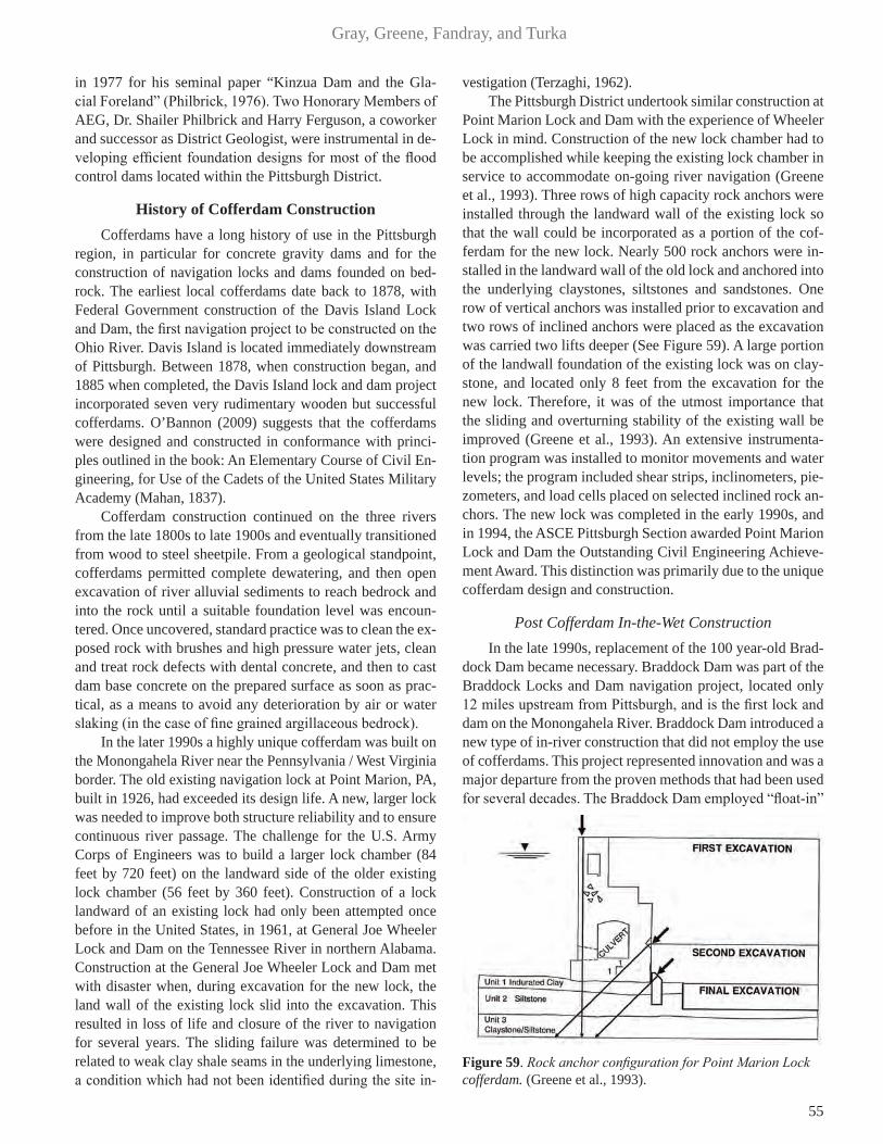
55
Gray, Greene, Fandray, and Turka
in 1977 for his seminal paper “Kinzua Dam and the Gla-cial Foreland” (Philbrick, 1976). Two Honorary Members of AEG, Dr. Shailer Philbrick and Harry Ferguson, a coworker and successor as District Geologist, were instrumental in de-veloping efficient foundation designs for most of the flood control dams located within the Pittsburgh District.
History of Cofferdam Construction Cofferdams have a long history of use in the Pittsburgh
region, in particular for concrete gravity dams and for the construction of navigation locks and dams founded on bed-rock. The earliest local cofferdams date back to 1878, with Federal Government construction of the Davis Island Lock and Dam, the first navigation project to be constructed on the Ohio River. Davis Island is located immediately downstream of Pittsburgh. Between 1878, when construction began, and 1885 when completed, the Davis Island lock and dam project incorporated seven very rudimentary wooden but successful cofferdams. O’Bannon (2009) suggests that the cofferdams were designed and constructed in conformance with princi-ples outlined in the book: An Elementary Course of Civil En-gineering, for Use of the Cadets of the United States Military Academy (Mahan, 1837).
Cofferdam construction continued on the three rivers from the late 1800s to late 1900s and eventually transitioned from wood to steel sheetpile. From a geological standpoint, cofferdams permitted complete dewatering, and then open excavation of river alluvial sediments to reach bedrock and into the rock until a suitable foundation level was encoun-tered. Once uncovered, standard practice was to clean the ex-posed rock with brushes and high pressure water jets, clean and treat rock defects with dental concrete, and then to cast dam base concrete on the prepared surface as soon as prac-tical, as a means to avoid any deterioration by air or water slaking (in the case of fine grained argillaceous bedrock).
In the later 1990s a highly unique cofferdam was built on the Monongahela River near the Pennsylvania / West Virginia border. The old existing navigation lock at Point Marion, PA, built in 1926, had exceeded its design life. A new, larger lock was needed to improve both structure reliability and to ensure continuous river passage. The challenge for the U.S. Army Corps of Engineers was to build a larger lock chamber (84 feet by 720 feet) on the landward side of the older existing lock chamber (56 feet by 360 feet). Construction of a lock landward of an existing lock had only been attempted once before in the United States, in 1961, at General Joe Wheeler Lock and Dam on the Tennessee River in northern Alabama. Construction at the General Joe Wheeler Lock and Dam met with disaster when, during excavation for the new lock, the land wall of the existing lock slid into the excavation. This resulted in loss of life and closure of the river to navigation for several years. The sliding failure was determined to be related to weak clay shale seams in the underlying limestone, a condition which had not been identified during the site in-
vestigation (Terzaghi, 1962).The Pittsburgh District undertook similar construction at
Point Marion Lock and Dam with the experience of Wheeler Lock in mind. Construction of the new lock chamber had to be accomplished while keeping the existing lock chamber in service to accommodate on-going river navigation (Greene et al., 1993). Three rows of high capacity rock anchors were installed through the landward wall of the existing lock so that the wall could be incorporated as a portion of the cof-ferdam for the new lock. Nearly 500 rock anchors were in-stalled in the landward wall of the old lock and anchored into the underlying claystones, siltstones and sandstones. One row of vertical anchors was installed prior to excavation and two rows of inclined anchors were placed as the excavation was carried two lifts deeper (See Figure 59). A large portion of the landwall foundation of the existing lock was on clay-stone, and located only 8 feet from the excavation for the new lock. Therefore, it was of the utmost importance that the sliding and overturning stability of the existing wall be improved (Greene et al., 1993). An extensive instrumenta-tion program was installed to monitor movements and water levels; the program included shear strips, inclinometers, pie-zometers, and load cells placed on selected inclined rock an-chors. The new lock was completed in the early 1990s, and in 1994, the ASCE Pittsburgh Section awarded Point Marion Lock and Dam the Outstanding Civil Engineering Achieve-ment Award. This distinction was primarily due to the unique cofferdam design and construction.
Post Cofferdam In-the-Wet ConstructionIn the late 1990s, replacement of the 100 year-old Brad-
dock Dam became necessary. Braddock Dam was part of the Braddock Locks and Dam navigation project, located only 12 miles upstream from Pittsburgh, and is the first lock and dam on the Monongahela River. Braddock Dam introduced a new type of in-river construction that did not employ the use of cofferdams. This project represented innovation and was a major departure from the proven methods that had been used for several decades. The Braddock Dam employed “float-in”
Figure 59. Rock anchor configuration for Point Marion Lock cofferdam. (Greene et al., 1993).
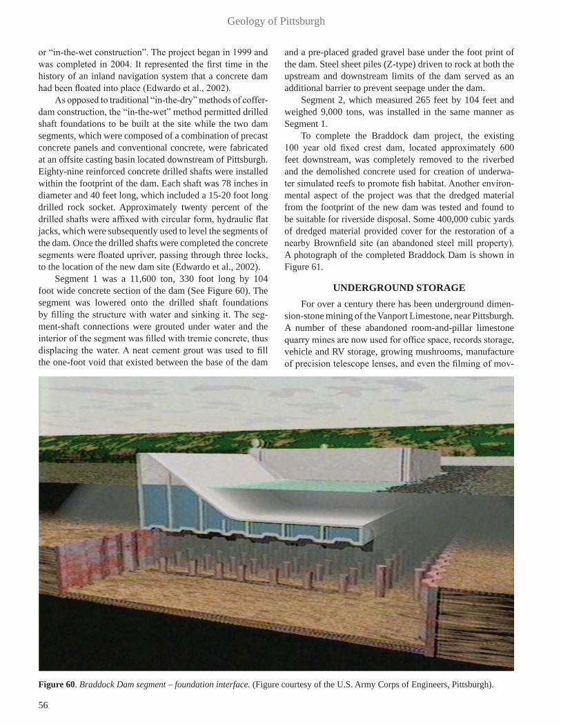
56
Geology of Pittsburgh
or “in-the-wet construction”. The project began in 1999 and was completed in 2004. It represented the first time in the history of an inland navigation system that a concrete dam had been floated into place (Edwardo et al., 2002).
As opposed to traditional “in-the-dry” methods of coffer-dam construction, the “in-the-wet” method permitted drilled shaft foundations to be built at the site while the two dam segments, which were composed of a combination of precast concrete panels and conventional concrete, were fabricated at an offsite casting basin located downstream of Pittsburgh. Eighty-nine reinforced concrete drilled shafts were installed within the footprint of the dam. Each shaft was 78 inches in diameter and 40 feet long, which included a 15-20 foot long drilled rock socket. Approximately twenty percent of the drilled shafts were affixed with circular form, hydraulic flat jacks, which were subsequently used to level the segments of the dam. Once the drilled shafts were completed the concrete segments were floated upriver, passing through three locks, to the location of the new dam site (Edwardo et al., 2002).
Segment 1 was a 11,600 ton, 330 foot long by 104 foot wide concrete section of the dam (See Figure 60). The segment was lowered onto the drilled shaft foundations by filling the structure with water and sinking it. The seg-ment-shaft connections were grouted under water and the interior of the segment was filled with tremie concrete, thus displacing the water. A neat cement grout was used to fill the one-foot void that existed between the base of the dam
and a pre-placed graded gravel base under the foot print of the dam. Steel sheet piles (Z-type) driven to rock at both the upstream and downstream limits of the dam served as an additional barrier to prevent seepage under the dam.
Segment 2, which measured 265 feet by 104 feet and weighed 9,000 tons, was installed in the same manner as Segment 1.
To complete the Braddock dam project, the existing 100 year old fixed crest dam, located approximately 600 feet downstream, was completely removed to the riverbed and the demolished concrete used for creation of underwa-ter simulated reefs to promote fish habitat. Another environ-mental aspect of the project was that the dredged material from the footprint of the new dam was tested and found to be suitable for riverside disposal. Some 400,000 cubic yards of dredged material provided cover for the restoration of a nearby Brownfield site (an abandoned steel mill property). A photograph of the completed Braddock Dam is shown in Figure 61.
UNDERGROUND STORAGE For over a century there has been underground dimen-
sion-stone mining of the Vanport Limestone, near Pittsburgh. A number of these abandoned room-and-pillar limestone quarry mines are now used for office space, records storage, vehicle and RV storage, growing mushrooms, manufacture of precision telescope lenses, and even the filming of mov-
Figure 60. Braddock Dam segment – foundation interface. (Figure courtesy of the U.S. Army Corps of Engineers, Pittsburgh).

57
Gray, Greene, Fandray, and Turka
ies (Kochanov and Bragonier, 2005). The second largest employer in Butler County is the
Boyers underground mine-storage facility, which is located approximately 40 miles north of Pittsburgh. This facility con-tains offices for six different agencies including the Office of Personnel Management, Social Security Administration, and The Smithsonian Institution, with a combined on-site payroll of some 3,000 Federal employees. In addition, this under-ground facility houses a private sector record storage firm.
The world’s largest underground mushroom growing facility is in Worthington, Pennsylvania, which is located about 35 miles northeast of Pittsburgh. This re-purposed former limestone quarry mine features a controlled en-try and egress at more than 300 feet below the ground surface and has been stabilized and improved for produc-tion for as far as three-quarters of a mile in from the en-try portal. The entire original mined area consists of about 150-miles of through-pillar passageways that had been created by the termination of the rock production more than
75 years ago. The mine environment, with its constant cool temperature (62 °F) and high humidity, is ideal for growing mushrooms.
The Wampum Mine facility, which is also located north of Pittsburgh, is currently used for records storage and was the site for filming portions of the movie, “The Zombies” (Kochanov and Bragonier, 2005). The mine had been used during the early years of the Atomic Age to store nuclear materials. The most unique use of the mine occurred in the late 1990s, when a telescope mirror, which at that time was the world’s largest single-piece optical element, was man-ufactured within the Wampum mine. The mirror blank was initially fabricated by Corning, Inc., and measured over 27 feet in diameter and was about nine inches thick. A Pitts-burgh firm, Contraves, converted a portion of the Wampum mine into an optical fabrication facility where the mirror was ground, polished and tested. The mirror was finished in 1997 and was installed in a telescope at the Mauna Kea Observatory in Hawaii.
Figure 61. Completed Braddock Dam in 2004. (Photo courtesy of the U.S. Army Corps of Engineers, Pittsburgh).

58
Geology of Pittsburgh
ENVIRONMENTAL CONCERNS
Abandoned Mine Lands One unintended and poorly considered legacy of the
mining of the abundant coal resources in the Pittsburgh re-gion are the mining related problems that remain, problems that are generally referred to as abandoned mine lands or AML. Included in AML problems are mine subsidence; unfilled or improperly filled shafts, slopes and drifts; mine and spoil pile (culm bank) fires; unstable slopes; gas prob-lems stemming from methane, carbon monoxide, carbon di-oxide or hydrogen sulfide; and acid mine drainage.
The coals were mined nearly everywhere in the Pitts-burgh region and now the AML problems are found near-ly everywhere as well. The shallow depth to the Pittsburgh Coal, it’s significant thickness and the early mining meth-ods and laws, came together to create an almost ideal envi-ronment for mine subsidence. Much of the area to the east and south of the city are underlain by shallow, abandoned room and pillar mining where the overburden thickness is less than 100 feet and often less than 50 feet. A engineering based study of subsidence over the Pittsburgh Coal (Gray et al., 1977) that was completed in 1976 determined that 251 of the 352 documented incidents of subsidence (about 71%) occurred in Allegheny County. This was attributed in part to the area being one of the earliest undermined and also to be-
ing one of the most densely populated sectors of the region.There are over 34,000 documented AML features in the
state and 296 documented AML sites in Allegheny County alone. Figure 62 shows that the current number of AML sites by county in Pennsylvania. As can be seen from Figure 62, the problem is extensive and the number of AML sites for all of the surrounding mined counties is similar. Figure 63 shows the distribution of individual AML sites in Allegheny County. The Federal Office of Surface Mining had defined three priority levels for pre-law AML sites under the Surface Mining Control and Reclamation Act of 1977 (SMCRA). They initiated an inventory of priority 1 (P1) and priority 2 (P2) AML sites which are the sites that are counted and are shown on Figure 62 and now the State maintains it (PA DEP, AML). Those sites are generally defined as requiring recla-mation to protect the public health and safety from extreme danger of the adverse effects (P1) or just from the adverse effects (P2) of coal mining practices. Priority 3, the sites requiring restoration of land and water resources because of environmental degradation previously caused by the ad-verse effects of coal mining, are generally not included in the AML inventory list. These sites, which include mine water discharges, abandoned surface mines and abandoned mine spoil dumps that are not included within P1 and P2 sites, are considered to have a very low priority for reclamation even though they are as ubiquitous as the P1 and P2 sites.
Figure 62. AML Sites in Pennsylvania by County (PADEP 2013).

59
Gray, Greene, Fandray, and Turka
Figure 63. AML Inventory in Allegheny County (PADEP 2013).

60
Geology of Pittsburgh
Hydrofracturing Fluids Associated with Natural Gas In recent years there has been a boom in the exploration
and production of natural gas and natural gas liquids associ-ated with the Marcellus Shale Formation (Pennsylvania De-partment of Natural Resources, 2014). Significant secondary natural gas recovery has resulted from physically improv-ing the permeability of the shale host rock through the pro-cess of hydraulic fracturing (fracking) in conjunction with horizontal drilling (Figure 64). However, there is controver-sy concerning the volume, chemical additives and ultimate fate of fluids used in the hydraulic fracturing (fracking) pro-cess. Some 6 to 10 million gallons of fresh water combined with surfactants, chemical additives, and propping sand are used to frack a single well, and to keep the induced fractures open to radially inward flow of formation gas. The actual volume of water, sand and chemicals used is largely depen-dent on the length of the lateral leg of the borehole. Fluids used in the hydrofracturing process return to the surface as flowback fluid, which must be recovered with the enhanced flow of natural gas, then treated appropriately and disposed in a regulatory/permitted manner. Major flowback constitu-ents of regulatory concern are released 1) chlorides and 2) total dissolved solids, both which have been used to finger-print the fluids, if and when they may be detected in surface water. Some of the drillers have elected to dispose of the recovered fluids in Class 2 deep injection wells in neighbor-ing Ohio. Prior studies by the Army Corps of Engineers (US-ACE, 2012) have shown that the quality of the Monongahela River water has been a concern in regards to the Federal Clean Water Act (as amended). The Corps has confirmed that the primary water quality problems within the Monongahela River watershed are related to acid mine drainage, traditional gas drilling, industrial/municipal pollution and in some cas-es Marcellus Shale gas production. State and Federal envi-ronmental agencies are working with the gas drilling firms to ensure that fair but important environmental limits are placed on the disposal of flowback recovery fluids.
Low Level Nuclear Waste – Shallow Land Disposal Area
The Parks Township Shallow Land Disposal Area (SLDA) site, located approximately 23 miles east-northeast of Pittsburgh, encompasses 44 acres of private land present-ly owned by BWX Technologies. Land use within the vicin-ity of the SLDA site is mixed, consisting of small residential communities, individual rural residences, small farms with croplands and pastures, idle farmland, forested areas, and light industrial properties (USACE, 2002).
The Nuclear Materials and Equipment Corporation (NUMEC), which was a predecessor of BWX Technologies, disposed of low level radioactive waste (LLW) materials, gen-erated from national defense programs, onsite between 1961 and 1970 in accordance with Atomic Energy Commission
regulations (predecessor to the present Nuclear Regulatory Commission). BWX Technologies presently is licensed by the Nuclear Regulatory Commission to properly maintain the site to ensure the protection of caretaker staff and of the general surrounding public. The SLDA site consists of ten trenches containing contaminated soil and other waste materials. The estimated quantity of contaminated waste material from the trenches is approximately 24,300 cubic yards. This equates to the area of a football field twelve feet deep. The contaminated waste included uranium, thorium, americium and plutonium.
In the early 1900s, the Upper Freeport Coal was deep-mined at a depth of 60 to 100 feet beneath the uphill portion of the site and surface mined later on the downhill portion (USACE, 2002). Nine of the trenches are on the uphill por-tion of the site in 11 to 16 feet of Pleistocene terrace deposits that overlie 54 to 80 feet of shale and sandstone, above the mined Upper Freeport Coal. The tenth trench is in the strip mine downhill of the other trenches, located within the strip mine spoil, and rests on a clay and shale layer below the Upper Freeport Coal.
In January 2002, Congress directed the U.S. Army Corps of Engineers to clean up radioactive waste at the SLDA site. At the time of this writing all of the excavated contaminated material has been packaged and transported from the project site to a secure landfill meeting containment requirements of the Federal RCRA (Resource Conservation and Recovery Act of 1976 as amended). The remedial action wastewater treatment plant (WWTP) has been disassembled and re-moved from the project site. The purpose of the WWTP was to capture, filter and contain suspended waste particulates from remedial action wastewater used during remediation activities (USACE, 2007). A late 2014 contract was planned
Figure 64. Schematic diagram of shale gas well hyrofracturing (Range Resources, 2014).

61
Gray, Greene, Fandray, and Turka
for construction of a new long-term waste water treatment plant at the site.
CONCLUSIONPittsburgh has a rich history, and its Three Rivers have
always played a major role in the City’s growth and develop-ment. No longer known as just “The Steel City,” Pittsburgh is a major metropolitan area rich with mineral resources and abundant surface and groundwater supplies. The City is now vibrant, with a bright future, with new construction and a greatly improved natural environment. Air quality has improved, as has the quality of the region’s three rivers, the Allegheny, Monongahela and the Ohio.
Western Pennsylvania enjoys abundant natural re-sources. Coal continues to dominate as the primary source of energy to fuel power plants. Natural gas produced from hydrofracturing of shale formations, also is a significant en-ergy resource. Acid mine drainage remains a legacy envi-ronmental impact from past coal mining.
Geohazards are present in the Pittsburgh region, including slope instability, mine subsidence, expansive shales and slags, and pyritic acid rock. The local infrastructure is aging and there is a need to repair major highways, including the Pennsylvania Turnpike, the oldest interstate in the nation. Pittsburgh is a city of bridges and many are in need of repair or replacement. The river navigation system of locks and dams is aging and one major replacement project is underway on the Monongahela River, with others being planned for the Ohio River.
Pittsburgh is a city with a bright future as its industrial base changes and the region’s abundant natural resources are utilized. Water is plentiful and is used in many ways to benefit and enrich the citizens of the region.
ACKNOWLEDGEMENTS The authors would like to gratefully acknowledge the
support of Joseph Krupansky, P.G., AEG Cities of the World editor during key phases of the preparation of this paper. His constant encouragement and advice, especially during the peer review process and leading to publication of the paper were invaluable. Mr. Thomas Leech, P.E. of Gannett Flem-ing, Inc. generously contributed the section of the paper on Pittsburgh’s prominent bridges. The authors also wish to acknowledge the assistance of Jessica Krupansky, who graciously volunteered to improve a number of the graphics and figures contained within the paper. Her skills in elec-tronic graphics significantly contributed to the improvement of many of the figures, which resulted in an overall im-provement to the final manuscript. For the five years that the manuscript was in preparation, Wendy Kowalski of DiGioia Gray & Associates provided immeasurable support in man-aging the numerous drafts and facilitating frequent commu-nications between the four co-authors. Finally, the authors wish to acknowledge the comments and suggestions for ed-itorial improvements made by the peer reviewers during the
editorial review process. These comments and suggestions greatly improved the draft version of the final manuscript.
REFERENCESAbel, J. F., Jr. and Lee, R. T., 1980, Lithologic controls on sub-
sidence: Society of Mining Engineers of American Institute of Mining, Metallurgical and Petroleum Engineers (Preprint No. 80-314), 16 p.
Ackenheil, A. C., 1954, A Soil Mechanics and Engineering Geol-ogy Analysis of Landslides in the Area of Pittsburgh, Pennsyl-vania, Ph.D. Dissertation, University of Pittsburgh.
Adams, F. D., 1938, The Birth and Development of the Geologi-cal Sciences, Dover Publications, New York.
Adamson, J. H., Jr.; Graham, J. B.; and Klein, N. H., 1949, Groundwater Resources of the Valley-Filled Deposits of Allegheny County, Pennsylvania, Bulletin W8, Pennsylvania Geologic Survey, Harrisburg, PA.
Albert, G. D., 1896, The frontier forts of western Pennsylvania, in Report of the Commission to locate the site of the frontier forts of Pennsylvania, Vol. 2, Clarence M. Busch, State Print-er of Pennsylvania.
Amdt, H. A.; Carter, M. D.; and G. H. Wood, Jr., 1969, System-atic Jointing in the Western Part of the Anthracite Region of Eastern Pennsylvania, U. S. Geological Survey Bulletin, no. 1271-D, 18 p.
Baer, C., 1996, The Pennsylvania Railroad: Its Place in History 1846-1996, Chuck Blardone (Editor), Wayne, Pa, Philadel-phia Chapter, Pennsylvania Railroad Technical and Historical Society.
Baker, F. F. and Chieruzzi, R., 1959, Regional concept of land-slide occurrence, Highway Research Board, Bulletin 216, pp. 1-16.
Barnes, J. H., (Compiler), 2011, Directory of the Nonfuel-Mineral Producers in Pennsylvania: Pennsylvania Geological Survey, 4th Series, Open-File Report OFMR 11–01.1, 184 p., Porta-ble Document Format (PDF), (Data also available through an interactive web map at: http://www.dcnr.state.pa.us/topogeo/econresource/mineral_industries/mineral_resource_map/index.htm
Barnes, J. H., and Sevon, W. D., 2002, The Geological Story of Pennsylvania (3rd ed.): Pennsylvania Geological Survey, 4th ser., Educational Series 4, 44 p.
Bass, M.N., 1959, Basement rocks from the Sandhill well, Wood County, West Virginia, in Woodward, H. P., Chairman, A Symposium on the Sandhill Deep Well, Wood County, West Virginia: West Virginia Geological Survey Report of Investi-gations 18, pp. 145-168.
Bass, M. N., 1960, Grenville boundary in Ohio, Journal of Geol-ogy, Vol. 68, pp. 673-677.
Bennear, S., 1995, Pittsburgh railways, PCC Era / Early PAT, A Brief History, available at http://www.pittsburghtransit.info/index.html, accessed April 14, 2014.
Berryhill, H. L. Jr.; Schweinfurth, S. P.; and Kent, B. H., 1971, Coal-Bearing Upper Pennsylvanian and Lower Permian Rocks, Washington Area, Pennsylvania, Geological Survey Professional Paper 621, 47 p.
62
Geology of Pittsburgh
Bikerman, M.; Prellwitz, H. S.; Dembosky, J.; Simonetti, A.; and Bell. K., 1997, New phlogopite K-Ar dates and the age of southwestern Pennsylvania kimberlite dikes, Northeastern Geology and Environmental Sciences 19, pp. 302-308.
Bonk, J. G., 1964, The Weathering of Pittsburgh Redbeds, M.S. Thesis, Univ. of Pittsburgh, Pittsburgh, PA.
Bright, W., 2004, Native American Placenames of the Unites States, University of Oklahoma Press.
BrooklineConnection.com, available at www.brooklineconnection.com/history/Facts/Point1776.html, accessed March 26, 2012.
Brookline Connection, August 1964 photo of the P&WVRR tracks looking down at a Pittsburgh Railways inbound Shannon trolley approaching the trestle over McNeilly Road, available at http://www.brooklineconnection.com/history/Gal-lery/Tunnels.html, accessed October 6, 2014.
Bruhn, R. W.; Magnuson, M. O.; and Gray, R. E., 1978, Subsid-ence over the mined out Pittsburgh Coal, Presented at the American Society of Civil Engineers Spring Convention, Pittsburgh, PA, (ASCE Preprint 3293).
Bruhn, R. W.; Magnuson, M. O.; and Gray, R. E., 1981, Sub-sidence over abandoned mines in the Pittsburgh Coalbed, Proceedings of the 2nd International Conference, Ground Movements and Structures, J. Geddes (Editor), Cardiff, Wales, 1980, London, Pentech Press, pp. 142-156.
Carter, K. M. and K. J. Flaherty, 2011, The Old, the Crude, and the Muddy: Oil History in western Pennsylvania, Field Guide 20, The Geological Society of America.
Collier, S., 2014, Pittsburgh Magazine, The Way We Were – 150 Years of Pittsburgh History, Squirrel Hill Tunnel Construction, 1953, http://www.pittsburghmagazine.com/Pittsburgh-Magazine/December-2013/The-Way-We-Were/, accessed October 6, 2014.
Commonwealth of Pennsylvania, Department of Conservation and Natural Resources, 2008, Bureau of Topographic and Geologic Survey, Map 11 PA DCNR, Third Edition, Revised, 2000, Third Printing, 2008.
Compressed Air Magazine, 1974, Vol. 79 No. 11, November 1974.
Crawford, C.B. and Burn, K.N., “Building Damage from Ex-pansive Steel Slag Backfill”, Proceedings of the American Society of Civil Engineers, 96 (SM4):1325-1334 (1969), with discussion in four subsequent issues.
Cridlebaugh, B. S., Bridges and Tunnels of Allegheny County and Pittsburgh, Pennsylvania, available at http://pghbridges.com, accessed May 2, 2014.
D’Appolonia, E.; Alperstein, R.; and D’Appolonia, D. J., 1967, Be-havior of a colluvial slope, Proceedings of the American Society of Civil Engineers, Journal of Soil Mechanics & Foundations Division, 93(SM4) pp. 447-473.
Darby, W., 1980, available at http://www.mapsofpa.com/19th-century/1828-2668.jpg, from PITTSBURGH, page 101 from View of the United States, Historical, Geographical, and Statistical, by William Darby, Philadelphia: published by H. S. Tanner 1828.
Deere, D. U. and Patton, F. D., 1971, Slope stability in residual soils, Proceedings of the 4th Pan-American Conference on
Soil Mechanics and Foundation Engineering, American Soci-ety of Civil Engineers, New York, N.Y., 1: pp. 87-170.
Denny, C.S., 1956, Surficial Geology and Geomorphology of Pot-ter County, Pennsylvania, U.S. Geological Survey Profession-al Paper 288: 72 p.
Donahue, J. and Rollins, H. B., 1974, Conemaugh (Glenshaw) Marine Events, Field Guidebook for the Third Annual Meeting of the American Association of Petroleum Geologists, 104 p.
Donaldson, A. C., 1974, Pennsylvanian sedimentation of central Appalachians in Briggs, G. ed., Carboniferous of the South-eastern United States, The Geological Society of America, Special Paper 148, pp. 47-78.
Dougherty, M. T. and Barsotti, N. J., 1972, Structural damage and potentially expansive shale minerals, Bulletin of the Association of Engineering Geologists, Vol. IX, No. 2.
DuMontelle, P. B.; Bradford, S. C.; Bauer; R. A.; and Killey, M. M., 1981, Mine Subsidence in Illinois: Facts for the Homeown-er Considering Insurance; Champaign, Illinois State Geologi-cal Survey, Environmental Geology Notes 99, 24 p.
Eavenson, H. N., 1939, Coal through the Ages, American Insti-tute of Mining and Metallurgical Engineers.
Eavenson, H. N., 1942, The First Century and a Quarter of Amer-ican Coal Industry: Baltimore, Waverly Press, Inc., 701 p.
Eckel, E. B. (Editor), 1958, Landslides and engineering practice, Highway Research Board, Special Report No. 29, pp. 232.
Edmunds, W. E.; Skema, V. W.; and Flint, N. K., 1999, The Ge-ology of Pennsylvania, Chapter 10, Pennsylvania Formations, Lebanon, PA, Bayer Printing Company.
Edmunds, W. E., 1999a, Coal in Pennsylvania, Pennsylvania Geo-logical Survey Educational Series 7, Harrisburg, PA.
Edwardo, H.; Karaffa, W.; and Greene, B. H., 2002, First Floating Dam, The Military Engineer, No. 617, pp. 61-62.
ENR, 1960, “Structures Don’t Settle in This Shale: but Watch Out for Heave”, Engineering News Record, February 4, 1960, McGraw-Hill, NY.
ExplorePAhistory.com website, Historical Markers, Kier Refinery Historical Marker, available at http://explorepahistory.com/hmarker.php?markerId=1-A-A7, accessed August 2014.
ExplorePAHistory.com website, Historical Markers, The Roe-blings Historical Marker, available at http://explorepahistory.com/hmarker.php?markerId=1-A-250, accessed August 2014.
Faill, R. T. (compiler), 2004, Earthquake Catalog and Epicenter Map of Pennsylvania, Pennsylvania Geological Survey, 4th Series, Map 69.
Ferguson, H. F., 1967, Valley stress release in the Allegheny Pla-teau, Bulletin of the Association of Engineering Geologists, Vol. 4, No. 1, pp. 67-71.
Ferguson, H. F., 1974, Geologic observations and geotechnical effects of valley stress relief in the Allegheny Plateau, Paper presented at American Society of Civil Engineering Water Resource Engineering Meeting, Los Angeles, California, January 1974, 31 p.
Ferguson, H.F. and Hamel, J.V., 1981, Valley stress relief in flat-lying rocks, Proceedings of the International Symposium
63
Gray, Greene, Fandray, and Turka
on Weak Rock, Tokyo, 21-14 September 1981, Akai, K., Hayashi, M., and Nishimatsu, Y. (Editors), A.A. Balkema, Rotterdam vol. 2., pp. 235-1240.
Ferm, J. C. and Cavaroc, V.V., 1969, Guidebook, Field guide to Allegheny deltaic deposits in the upper Ohio Valley with a commentary on deltaic aspects of Carboniferous rocks in the northern Appalachian Plateau, Ohio Geological Society and Pittsburgh Geological Society, Spring Field Trip, 1969, p. 19.
Ferm, J. C. 1970, Allegheny deltaic deposits, in Morgan, J.P. (Ed-itor), Deltaic Sedimentation; Modern and Ancient: Society of Economic Paleontologists and Mineralogists Special Publica-tion 15, pp. 246-255.
Ferm, J. C., 1974, Carboniferous environmental models in east-ern United States and their significance, Geological Society of America Special Paper 148, pp. 79-95.
FHA (United States Department of Transportation - Federal Highway Administration), User Guidelines for Waste and Byproduct Materials in Pavement Construction, Pub. No. FHWA-RD-97148, available at http://www.fhwa.dot.gov/publications/research/infrastructure/structures/97148/index.cfm, accessed July 2012.
Finch, R. G., 1925, The Story of the New York State Canals (PDF). New York State Engineer and Surveyor (republished by New York State Canal Corporation), accessed September 25, 2012.
Fiscor, S., 2011, The most productive underground coal mining method takes a hit, Coal Age News, February 24, 2011.
Flaherty, K. J. and Flaherty, T., III, 2014, Oil and Gas in Pennsylva-nia, Educational Series 8, Bureau of Topographic and Geologic Survey, Fourth Series, Harrisburg, PA.
Fleeger, G. M.; Goode, D. J.; Buckwalter, T. F.; and Risser, D. W., 1999, Hydrologic effects of the Pymatuning Earthquake of September 25, 1998, in Northwestern Pennsylvania, U.S. Geological Survey Water-Resources Investigations Report 99-4170, 8 p.
Fleming, G. T., 1928, Pittsburgh, How to See it: A Complete, Reliable Guide book with Illustrations, the Latest Map and Complete Index, arranged and edited by George T. Fleming, p. 19-20.
Fleming, R. W. and Taylor, F. A., 1980, Estimating the Costs of Landslide Damage in the United States, U.W. Geological Survey Circular 832.
Flint, N. K., 1965, Geology and Mineral Resources of southern Somerset County, Pennsylvania, Pennsylvania Geological Sur-vey County Report, 4th series, no. 56A, 267 p.
Fontaine, T., May (2012), “Connector boosts Port Authority rid-ership”, Pittsburgh Tribune-Review. Retrieved 2 June 2012.
Gallaher, J. T., 1973, Summary Ground-water Resources of Allegheny County, Pennsylvania, Pennsylvania Geological Survey, 4th series, Water Resource Report 35.
Gardner, G.D., 1980, An introduction to the geology of Pitts-burgh and its impact on the activities of man, in Guidebook for the 45th Annual Field Conference of Pennsylvania Geolo-gists, Pittsburgh.
GeoTDR, Inc., October 2001, Effects of Undermining Interstate Route 70, South Strabane Township, Washington County, Pennsylvania, November 1999 – to October 2000, Prepared for Pennsylvania Department of Environmental Protection, Bureau of Mining and Reclamation, Harrisburg, Pennsylvania.
Gordon, D.W. and Dewey, J.W., 1999, Earthquakes, in Schultz, C.H., (Editor), The Geology of Pennsylvania, Pennsylvania Geo-logical Survey, 4th Series, Special Publication 1, pp. 762-769.
Gray, R. E., 1983, Alternative measures in undermined areas, Proceedings of the 1983 GSA-Northeastern Section Meeting, Northeastern Environmental Science, Vol. 2, No. 2.
Gray, R. E., 1988, Coal mine subsidence and structures, in Pro-ceedings on Mine Induced Subsidence: Effects on Engineered Structures, H. Siriwardane (Editor), Nashville, TN: ASCE Ge-otechnical Division, May 1988. (GT Special Publication 19).
Gray, R. E., 1999, Land Subsidence-Mines, in Schultz, C.H. (editor), The Geology of Pennsylvania, Pennsylvania Bureau of Topographic and Geologic Survey, Harrisburg, PA.
Gray, R. E. and Bruhn, R. W., 1984, Coal mine subsidence eastern United States, in Man Induced Land Subsidence, T. Holzer (Editor), Reviews in Engineering Geology VI Colora-do: Geological Society of America.
Gray, R. E.; Bruhn, R. W.; and Turka, R. J., 1977, Study and Analysis of Surface Subsidence Over the Mined Pittsburgh Coalbed, Unit-ed States Bureau of Mines, July, 1977.
Gray, R. E. and Donovan, T. D. Discussion of slope stability in residual soils, Proceedings of the Fourth Panamerican Conference on Soil Mechanics and Foundation Engineering, Vol. 3, 1971.
Gray, R. E.; Ferguson, H. F.; and Hamel, J. V., 1979, Slope stability in the Appalachian Plateau of Pennsylvania and West Virginia, in Voight, B., (Editor), Developments in Geotech-nical Engineering, Vol. 14B, “Rockslides and Avalanches”: New York: American Elsevier Publishing Company.
Gray, R. E.; Gamble, J. C.; McLaren, R. J.; and Rogers, D. J., 1974, State of the art of subsidence control, Report ARC 73 11 2550, prepared for the Appalachian Regional Commission and Pennsylvania Department of Environmental Resources by General Analytics, Inc., (predecessor of company to GAI Consultants, Inc.), Monroeville, PA, (Available from NTIS, PB242465).
Gray, R. E. and Gardner, G. D., 1977, Processes of colluvial slope development, McMechen, WV, Proceedings of the Symposium of the International Association of Engineering Geology: Landslides and Other Mass Movements, Prague, Czechoslovakia, 1977, (Bulletin IAEG, no. 16).
Gray, R.E.; Bruhn, R.W.; and Knott, D. L., 1996, “Subsidence Misconceptions and Myths”, Proceedings of 15th Interna-tional Conference on Ground Control in Mining, edited. By Ozdemir, L.; Hanna, K.; Haramy, K.Y.; and Peng, S., Golden, CO, August 1996.
Gray, R. E.; Hamel, J. V.; and Adams, W. R., Jr., 2011, Landslides in the vicinity of Pittsburgh, Pennsylvania, in Ruffolo, R.M., and Ciampaglio, C.N., (Editors), From the Shield to the Sea: Geological Field Trips From the 2011 Joint Meeting of the GSA Northeastern and North-Central Sections, Geological

64
Geology of Pittsburgh
Society of America Field Guide 20, pp. 61-85.
Gray, R. E. and Meyers, J. F., 1970, Mine subsidence and support methods in the Pittsburgh Area, ASCE Journal of the Soil Me-chanics and Foundations Division 96, No. SM4, July, 1970.
Greene, B.H. and Christ, C.A., 1998, Mistakes of man: The Austin dam disaster of 1911: Pennsylvania Geology, Vol. 29, No. 2 of 3, pp. 7-14.
Greene, B. H.; Gerlach, J. A.; and Schaffer, A., 1993, Geotech-nical design and instrumentation of an anchored cofferdam, Bulletin Association of Engineering Geologists, Vol. XXX, No. 3., pp. 265-279.
Gregory, C. E., 1980, A Concise History of Mining, New York, Pergamon Press, 259 p.
HAER, 1985, No. PA – 70 (Historic American Engineering Record) Mid-Atlantic Region National Park Service, Depart-ment of the Interior, Philadelphia, Pennsylvania.
Hamel, J. V., 1969, Stability of Slopes in Soft, Altered Rocks, Ph.D. Thesis, University of Pittsburgh, Pittsburgh, Pennsylva-nia No. 70-23, 232 – Univ. Microfilms, Ann Arbor, Michigan.
Hamel, J. V., 1972, The Slide at Brilliant Cut, in E.J. Cording (Editor), Stability of Rock Slopes, Proceedings 13th Sympo-sium on Rock Mechanics, Univ. of Illinois, Urbana, Ill., 1971. American Society of Civil Engineers, New York, N.Y., pp. 487-510.
Hamel, J. V., 1980, Geology and slope stability in western Penn-sylvania, Bulletin Association of Engineering Geologists, Vol. 17, pp. 1-26.
Hamel, J. V., 1998, Mechanism of Pleistocene rock slides Near Pittsburgh, Pennsylvania: International Journal of Rock Me-chanics and Mining Science, Vol. 35, No. 4-5, Paper No. 32.
Hamel, J. V., 2004, Discussion of residual shear strength mobi-lized in first-time slope failures, Journal of Geotechnical and Geoenvironmental Engineering, ASCE, Vol. 130, pp. 544- 546.
Hamel, J. V., 2011, Sewage treatment plant on a major fault zone, Sewickley Township, Pennsylvania, Proceedings of the 46th Annual Northeastern and 45th Annual Joint Meeting of the Geological Society of America, Pittsburgh, PA, Program with Abstracts.
Hamel, J. V. and Flint, N. K., 1969, A slope stability study on inter-state routes 279 and 79 near Pittsburgh, Pennsylvania. Report by Departments of Civil Engineering and Earth and Planetary Sciences, University of Pittsburgh to Pennsylvania Department of Highways and U.S. Department of Transportation, Bureau of Public Roads.
Hamel, J. V. and Flint, N. K., 1972, Failure of colluvial slope, American Society of Civil Engineers, Soil Mechanics and Foundations Division Journal, Vol. 98, No. SM2, pp. 167-180.
Hammarstrom, J. M.; Brady, K.; and Cravotta, C. A., III, 2005, Acid-rock drainage at Skytop, Centre County, Pennsylvania, 2004, U.S. Geological Survey, Open File Report, pp. 2005-1148.
Hannibal, J. T.; Gerke, T. L.; McGuire, M. K.; Edenborn, H.M.; Holstein, A.L.; and Parker, D., 2011, Early industrial geology of western Pennsylvania and eastern Ohio: Early gristmills
and iron furnaces west of the Alleghenies and their geologic contexts, in Ruffolo, R. M., and Ciampaglio, C. N., (Editors), From the Shield to the Sea: Geological Field Trips from the 2011 Joint Meeting of the GSA Northeastern and North-Cen-tral Sections, Geological Society of America Field Guide 20, pp. 143-167.
Harper, J.A., 1990, Fossil Collecting in the Pittsburgh Area. Pitts-burgh Geological Society, Field Trip Guidebook, 50 p.
Harper, J. A., 1997, Of Ice and Waters Flowing: The formation of Pittsburgh’s Three Rivers: Pennsylvania Geology, Vol. 28, No. 3 of 4, pp. 2-8.
Harper, J. A., 2002, Lake Monongahela: Anatomy of an immense ice age pond: Pennsylvania Geology, Vol. 32, No. 1, pp. 2-12.
Harper J. A., 2012, personal communication, Pennsylvania Geo-logical Survey, 400 Waterfront Drive, Pittsburgh, PA, 15222.
Hatcher, R. D., Jr., 2004, Regional geology of north America, southern and central Appalachians, Encyclopedia of Geology, Elsevier Publishers, London, p. 72-81.
Hebblewhite B., (eds.), 2001, Regional horizontal movements associated with longwall mining, in Coal Mine Subsidence - Current Practice and Issues, pp. 113 - 122, presented at Coal Mine Subsidence - Current Practice and Issues, Maitland, NSW, August 1, 2001.
Hebblewhite B., and Gray R., 2014, “Non-conventional Subsid-ence Behavior and Impacts” – Ryerson State Park Dam, Penn-sylvania USA, Case Study, Proceedings of the 9th Triennial Conference on Mine Subsidence, Australia.
Hebblewhite, B. K., and Gray, R. E., 2014a, “Non-conventional Surface Ground Behavior Induced by Underground Mining in Pennsylvania”, Geohazards Impacting Transportaion in Appa-lachian website at http://www.marshall.edu/cegas/geohazards/, 14th Annual Technical Forum.
Heyman, L., 1970, History of Pittsburgh’s rivers, in Wagner, et al (editors), 1970 Geology of the Pittsburgh Area, General Ge-ology Report G59, Pennsylvania Geological Survey, Fourth Series, Harrisburg, PA.
Inners, J. D., 1999, Metallic mineral deposits – sedimentary and meta sedimentary iron deposits, in Schultz, C. H., (Editor), The Geology of Pennsylvania, Pennsylvania Bureau of Topographic and Geologic Survey, Harrisburg, PA.
Johnson, L.R., 1978, The Headwaters District, A History of the Pittsburgh District, U.S. Army Corps of Engineers, prepared for the U.S. Army Corps of Engineers, 380 p.
Karol, R.H., 2003, Chemical Grouting and Soil Stabilization, Third Edition, Revised and Expanded, Marcel Dekker, AG, Basel, Switzerland.
Kidney, W. C., 1999, Pittsburgh’s Bridges, Architecture and Engi-neering, Pittsburgh History and Landmarks Foundation, 26 p.
King, P. B., 1977, The Evolution of North America, Princeton University Press, 197 p.
Kochanov, W. and Bragonier, W., 2005, The Vanport Limestone at Wampum, in Guidebook for the 70th Annual Field Confer-ence of Pennsylvania Geologists, Sharon, Pennsylvania, 2005.
Kurka, M.; Gamer, M.; and Retzlaff, S, 2014, Energizing invest-ments in hydropower, in The Military Engineer, Vol. 106,

65
Gray, Greene, Fandray, and Turka
No. 690.
Ladd, G. E., 1927-1928. Landslides and their relation to high-ways, A report of observations made in West Virginia and Ohio to determine the cause of slides and devise means of control, Public Roads, Part 1, 8 (2): 21-35; Part 2, 9 (8), pp. 153-163.
Law, A. S., 1997, The Great Flood, Johnstown Pennsylvania, 1889, Johnstown Area Heritage Association, 106 p.
Legget, R. F. and Karrow, P. F., 1983, Handbook of Geology in Civil Engineering, McGraw-Hill Book Company, 1,340 p., 50 chapters, five appendices, 771p., with illustrations.
Leighton, H., 1947, Guidebook to the geology about Pittsburgh, PA, Pennsylvania Geological Survey, 4th Series, Bulletin G-17, 35 p., with illustrations and geologic map, (Reprint, without change, of 1939 edition).
Loehlein, W. C., 2010, personal communication, U.S. Army Corps of Engineers, Pittsburgh District, 1000 Liberty Avenue, Pittsburgh, PA, 15222.
Lorant, S., 1964, Pittsburgh: The Story of an American City, First Edition. Garden City: Doubleday and Company.
Lorant, S., 1975, Pittsburgh, the Story of an American City, Au-thors Edition Inc, Lenox, MA.
Lord, R. (2010). Steelers look to add seats to Heinz Field, Pitts-burgh Post-Gazette. Retrieved 22 January 2011.
Mahan, D. H., 1837, An Elementary Course of Civil Engineering, United States Military Academy.
McCulloch, C. M.; Diamond, W. P.; Bench, B. M; and Deul, M., 1975, Selected Geologic Factors Affecting Mining of the Pittsburgh Coalbed, U.S. Bureau of Mines Report of Investi-gations 8093, 72 p.
McCullough, D. G., 1968, The Johnstown Flood, Simon and Schuster, New York, 302 p.
McElroy, T. A., 2000, Groundwater Resources of Somerset Coun-ty Pennsylvania, Open-File Report 2000-02, Pennsylvania Geological Survey, Fourth Series, Harrisburg, PA.
Moldenke, R., 1920, Charcoal Iron: Lime Rock, Connecticut, Salisbury Iron Corporation, 64 p.
National Park Service, U.S. Department of the Interior, Alleghe-ny Portage Railroad National Historic Site, available at http://www.nps.gov/alpo/historyculture/staplebend.htm, accessed September 25, 2013.
National Park Service, 2008, U.S. Department of the Interior, Johnstown Flood Memorial, Geologic Resource Evaluation Report.
Nickelsen, R. P. and Hough, V. N., 1967, Jointing in the Appa-lachian Plateau of Pennsylvania, The Geological Society of America Bulletin, Vol. 78, No. 5, pp. 609-629.
NOAA website, NWS Pittsburgh Climate Data, Various Records for Pittsburgh, available at http://www.erh.noaa.gov/pbz/re-cords.htm, accessed August 2014.
Nordstrom, D. K. and Alpers, C. N., 1999, Geochemistry of acid mine waters, in Plumlee, G. S. and Logsdon, M. J., (Editors), The environmental geochemistry of mineral deposits, Part A.: Processes, techniques, and health issues, Society of Econom-
ic Geologists, Inc., Reviews in Economic Geology, Vol. 6A, pp. 133-160.
O’Bannon, P., 2009, Working in the Dry: Cofferdams, In-River Construction, and the United States Army Corps of Engi-neers, prepared by Gray and Pape, Inc., Cincinnati for the U.S. Army Corps of Engineers.
Old Pittsburgh Maps-Pittviewer, Pittsburgh’s Incline History, available at http://oldpittmaps.wordpress.com/2012/05/02/pittsburghs-incline-history, accessed May 2, 2012.
O’Neil, B. J., Jr., 1974, Greater Pittsburgh Region Construction Aggregates, Mineral Resource Report 67, Pennsylvania Geo-logic Survey, Fourth Series, Harrisburg, PA.
O’Neill, B. (8 June 2008). “North Shore Connector, you’re looking good”, Pittsburgh Post-Gazette. Retrieved 22 January 2011.
PA DEP, 2013, AML Program Information website, available at http://www.depweb.state.pa.us/portal/server.pt/community/aml_program_information/21360
Paul, W. J. and Plein, L. N., 1935, Methods of Development and Pillar Extraction in Mining the Pittsburgh Coalbed in Pennsylvania, West Virginia and Ohio, U.S. Bureau of Mines Information Circular 6872, 31 p.
Peltier, L.C., 1950. The geographic cycle in periglacial regions as it is related to climatic geomorphology, Association American Geographers, 40: 214-36.
PennDOT District 11 website, Commonwealth of Pennsylvania, Pennsylvania Department of Transportation, available at http://www.dot.state.pa.us/penndot/districts/district11.nsf/Dis-trict11-0, accessed April 15, 2014.
Penner, E.; Eden, W. J.; and Gillott, J. E., 1973, Floor heave due to biochemical weathering of shale, Proceedings of the Eighth International Conference on Soil Mechanics and Foundation Engineering; Vol. 2, Part 2, Session 4. pp. 151-158; Moscow.
Pennsylvania Bureau of Topographic and Geologic Survey, 2007, Pennsylvania Geological Survey, 2007, 4th ser., Map 7, scale 1:2,000,000, Third Edition, 1990; Fourth Printing, Slightly Revised, 2007.
Pennsylvania Department of Natural Resources (DCNR), 2014, Marcellus Gas, available athttp://www.portal.state.pa.us/por-tal/server.pt/community/marcellus_shale/20296
Pennsylvania Department of Natural Resources (DCNR), 2015, Point State Park, available at http://www.dcnr.state.pa.us/stateparks/findapark/point/index.htm, accessed May 23, 2015.
Pennsylvania Geological Survey, 2005, Geologic units containing potentially significant acid-producing sulfide minerals: Penn-sylvania Geological Survey, 4th Series, Open-File Report OFMI 05–01.1, 9 p., Portable Document Format (PDF).
Pennsylvania Railroad, 1948, Pennsylvania Railroad Board of Directors Inspection Tour of the Physical Properties of the Pennsylvania Railroad in the Pittsburgh District, available at http://www.railsandtrails.com, accessed October 6, 2014.
Philbrick, S. S., 1953, Design of deep rock cuts in the Conemaugh Formation, Proceedings of the Symposium of Geology as Applied to Highway Engineering, 4th annual, Charleston, WV, Morris Harvey College and West Virginia State Road Commission, pp. 79-88.

66
Geology of Pittsburgh
Philbrick, S. S., 1959. Engineering geology of the Pittsburgh area, The Geological Society of America, Pittsburgh Meeting, Guidebook for Field Trips, pp. 191-203.
Philbrick, S. S., 1960, Cyclic sediments and engineering geology, Proceedings, 21st International Geological Congress, Part 20, pp. 49–63.
Philbrick, S. S., 1961, Old landslides in the Upper Ohio Valley. Paper presented at the Geological Society of America Annual Meeting.
Philbrick, S. S., 1976, Kinzua dam and the glacial foreland, in Coates, D.R. (Editor) Geomorphology and Engineering, Dowden, Hutchinson, and Ross, Stroudsburg, PA, pp. 175 – 197.
Piggott, R. J. and Eynon, P., 1978, Ground movements arising from the presence of shallow abandoned mine workings, in Geddes, J. D. (Editor) Proceedings of the 1st International Conference on Large Ground Movements and Structures, Cardiff. Pentech Press, London, pp. 749-80.
Pittsburgh, 2008, Encyclopedia Britannica, available at http://www.britannica.com/EBchecked/topic/462222/Pittsburgh, accessed November 6, 2008.
Plastikspork, 2008, Duquesne Incline from the top, available at http://commons.wikimedia.org/wiki/File:Duquesne_Incline_from_top.jpg, accessed November 17, 2014.
Poad, M. E., 1977, Single-entry development for longwall min-ing: research approach and results at Sunnyside No. 2 mine, Carbon County, Utah. [Washington]: Dept. of the Interior, Bureau of Mines.
Pomeroy, J. S., 1982, Landslides in the Greater Pittsburgh Region, Pennsylvania: U.S. Geological Survey Professional Paper 1229, 48 p.
Port Authority, North Shore Connector, available at http://www.portauthority.org/paac/portals/capital/NorthShore/NSCPro-jectMap.pdf, accessed May 2015.
Pryor, W.A., and E.G. Sable, 1974, Carboniferous of the East-ern Interior Basin, in G. Briggs, (ed.), Carboniferous of the Southeastern United States: Geological Society of America Special Paper, v. 148, p. 281-313.
Public Works, 1921, Liberty Tunnels Construction, Pittsburgh, Vol. 51, No. 4, July 23, 1921.
PWSA (Pittsburgh Water and Sewer Authority) website, History, available at http://www.pgh2o.com/history, accessed August 2014.
Radbruch-Hall, D. H; Colton, R. B.; Davies, W. E.; Lucchitta, I.; Skipp, B. A.; and Varnes, D. J., 1978. Landslide Overview Map of the Conterminous United States, U.S. Geological Survey Professional Paper 1183.
Rapp, A., 1967, Pleistocene activity and Holocene stability of hillslopes, with examples from Scandinavia and Pennsylva-nia, in L’Evolution des Versants, International Symposium on Geomorphology, Liege, June 1966. University of Liege, Liege, pp. 230-242.
Rathke, B., 1968, Panhandle Tunnel - Bridges and Tunnels of Allegheny County and Pittsburgh Bridges, Photo by Bob Rathke, 2/11/68, available at http://pghbridges.com/pittsbur-
ghE/0585-4477/panhandle_tun.htm, accessed October 6, 2014.
Reeger, J., 2003, “Diocese set to receive $5 million in Queen of Angels school cases”, Trib Live, Trib Total Media website, Copyright, 2014.
Richardson, G. B., 1932, Geology and Coal, Oil and Gas Re-sources of the New Kensington Quadrangle, Pennsylvania, U.S. Geological Survey Bulletin 829, US Government Print-ing Office, Washington, D.C.
Saylor, T. E., 1999, Precambrian and Lower Paleozoic metamor-phic and igneous rocks - in the subsurface, Chapter 3C, The Geology of Pennsylvania, C. H Shultz (Editor), Pennsylvania Geological Survey/Pittsburgh Geological Society, Special Publication 1, pp. 51-58.
Saylor, T. E., 1968, The Precambrian in the Subsurface of North-western Pennsylvania and Adjoining Areas, Pennsylvania Geological Survey Information Circular No. 62, 25 p.
Schamberger, C. K., 2003, Earthquake Hazard in Pennsylvania, Pennsylvania Geological Survey Educational Series 10, Sec-ond Edition, p. 8.
Schenk, C.; Pierce, B.; and Demas, A., 2012, USGS Releases First Assessment of Shale Gas Resources in Utica Shale: 38 trillion cubic feet, USGS Newsroom, available at http://www.usgs.gov/newsroom/article.asp?ID=3419&from=rss_home#.U_qtf9h0yM8, released October 4, 2012.
Schmitz, J. (26 November 2010). “North Shore Connector said to be on schedule and under budget”, Pittsburgh Post-Gazette. Retrieved 22 January 2011.
Schultz, A. P.; McDowell, R. C.; and Pohn, H., 2013, IGC Field Trip T227: Structural Transect of the Central Appa-lachian Fold-and-Thrust Belt, in Structural Transect of the Central Appalachian Fold-and-Thrust Belt: Harpers Ferry, West Virginia to Cumberland, Maryland July 15, 1989, American Geophysical Union, Washington, D. C.. DOI: 10.1002/9781118666951.ch1
Schultz, C. H., (Editor), 1999, The Geology of Pennsylvania, Penn-sylvania Geological Survey, Harrisburg, and The Pittsburgh Geological Society, Pittsburgh, pp. 162-180.
Sevon, W.D., 2000, Physiographic Provinces of Pennsylvania, Map 13. Pennsylvania Geological Survey, Harrisburg, PA.
Shank, W. H., 1981, The Amazing Pennsylvania Canals, Amer-ican Canal and Transportation Center, York, PA. Sixth Print-ing, June 1981.
Sharpe, C. F. S. and Dosch, E. F., 1942, Relation of soil-creep to earthflow in the Appalachian plateaus, Journal of Geomor-phology, 5: pp. 312-324.
Sholes, M. A.; Edmunds, W.E.; and Skema, V.W., 1979, The Economic Geology of the Upper Freeport Coal in the New Stanton Area of Westmoreland County, Pennsylvania: A Model for Coal Exploration, Pennsylvania Geological Survey Mineral Resources Report No. 75, 51 p.
Shumway, J., 2012, North Shore Connector Brings Down Park-ing Rates, filed by John Shumway of CBS Pittsburgh/KDKA. Published 26 March 2012.
Skema, V. W.; Sholes, M.A.; and Edmunds, W.E., 1982, The Economic Geology of the Upper Freeport Coal in Northeastern

67
Gray, Greene, Fandray, and Turka
Greene County, Pennsylvania, Pennsylvania Geological Survey Mineral Resources Report 76, 51 p.
Skempton, A. W., 1964, Long-term stability of clay slopes, Geo-technique, Vol. 14, pp. 77-101.
Slingerland, R. and Beaumont, C., 1989, Tectonics and sedimen-tation of the upper Paleozoic foreland basin in the central Appalachians, in: Slingerland, R. and Furlong, K.P., (Edi-tors), Sedimentation and Basin Analysis in Siliciclastic Rock Sequences, Vol. 2, Sedimentology and Thermal-Mechanical History of Basins in the Central Appalachian Orogen, Penn-sylvania State University, University Park, PA.
Socolow, A. A.; Berg, T. M.; Glover, A. D.; Dodge, C. H.; Schasse, H.W.; Shaulis, J. R.; Skema, V.W.; and Blust, S., 1980, Coal Resources of Pennsylvania, Pennsylvania Geological Survey, 4th Series Information Circular 88, 49 p.
Spanovich, M. and Fewell, R. B., 1969, The Subject is Pyrite, Charette, The Journal of the Pittsburgh Architectural Club, 49, 1, pp. 15-16.
Terzaghi, K., 1962, Does foundation technology really lag?, Engi-neering News Record, Vol. 168, No. 7, pp. 58-59.
Terzaghi, K. and Peck, R. B., 1948, Soil Mechanics in Engineer-ing Practice, Wiley, New York, N.Y., 566 pp.
Turka, R.J. and Gray, R.E., 2005, Impacts of Coal Mining in Humans as Geologic Agents, edited by Ehlen, J.; Haneberg, W. C.; and Larson R.A, Geological Society of America, Reviews in Engineering Geology, Volume XVI.
USACE, 2007, Record of Decision, Parks Shallow Land Dispos-al Area, Parks Township, Armstrong County, Pennsylvania, September 2007.
USACE, 2002, Preliminary Assessment, Parks Shallow Land Disposal Area, Parks Township, Armstrong County, Pennsyl-vania, March 2002.
USACE, 2012, Monongahela River Watershed Initial Watershed Assessment, Pittsburgh District, prepared in 2011 and revised in 2012.
U.S. Census Bureau, 2010 Census of Population, State and County Quick Facts, July 2014, available at http://factfinder2.census.gov
U.S. Energy Information Administration, Annual Energy Review 2011, available at www.eia.gov/aer, accessed September 27, 2012.
U.S. Steel Tower, available at https://en.wikipedia.org/wiki/U.S._Steel_Tower, accessed May, 2015.
USGS Water Data, Allegheny River, available at http://wdr.water.usgs.gov/wy2009/pdfs/03049500.2009.pdf
USGS Water Data, Monongahela, USGS 03085000 Monongahela River at Braddock, PA, available at http://waterdata.usgs.gov/nwis/
USGS, Stream gaging information, available at http://waterdata.usgs.gov/nwis/rt, USGS Real Time Water Data for the Nation.
Van Tuyl, D. W., 1951, Ground Water for Air Conditioning at Pittsburgh, Pennsylvania, Bulletin W 10, United States Geo-logical Survey and Pennsylvania Geological Survey, Fourth Series, Harrisburg.
Voight, B., 1974, A mechanism for “locking-in” orogenic stress, American Journal of Science, 274, pp. 662-665.
Waddington & Associates Pty Limited, 2002, ACARP Research Project No. C9067 Research into the Impacts of Mine Sub-sidence on the Strata and Hydrology of River Valleys and Development of Management Guidelines for Undermining Cliffs, Gorges and River Systems, Australia.
Wagner, W. R.; Heyman, L.; Gray, R. E.; Belz, D. J.; Lund, R.; Cate, A. S.; and Edgerton, C. D., 1970, Geology of the Pittsburgh Area, General Geology Report G 59, Pennsylvania Geological Survey, Fourth Series, Harrisburg, PA, 1970.
Wargo, K. A.; Roy, P.A.; Boscardin, M.A.; Miller, A. J.; and DiRocco, K., 2009, Tight fit tunneling, in Civil Engineering, March 2009.
Wyrick, G. G., and Borchers, J. W., 1981, Hydrologic effects of stress-relief fracturing in an Appalachian Valley: U.S. Geo-logical Survey Water-Supply Paper 2177.
White, J. R., 1979, Nineteenth century blast furnaces of Mercer County: A postscript: Mercer County History, v. 9, pp. 3-20.
Williams, E. H., 1960, Marine and fresh water fossiliferous beds in the Pottsville and Allegheny Groups of western Pennsylva-nia, Journal of Paleontology, Vol. 34, No. 5, pp. 908-922.
Williams, E. H. and Ferm, J. C., 1965, Sedimentary facies in the Lower Allegheny rocks of western Pennsylvania, Journal of Sedimentary Petrology, Vol. 35, No. 2, pp. 319-330.
Xanthakos, P. P.; Abramson, L.; and Bruce, D. A., 1994, Ground Control and Improvement, John Wiley & Sons, Inc., 913 p.
