geology of the golden gate headlands - san andreas faultsanandreasfault.org/geology of the golden...
TRANSCRIPT
Introduction
This field trip focuses on the rocks of the penin-sular headlands found just north and south of theGolden Gate, on lands of the Golden GateNational Recreation Area. Exposed in dramaticsea cliffs, these rocks not only form a spectacularbackdrop for the Golden Gate Bridge, but alsoprovide a detailed geologic record of Pacific basinand active continental margin processes spanningback 200 million years. This is arguably one ofthe longest records of its type in the world. Thesignificance of these rocks, however, goes beyondthe geologic history that they tell, for they, andothers of the Franciscan Complex associated withthem, played a critical role in developing our cur-rent understanding of subduction zone mechanicsand processes. Although the serpentine of theheadlands, and its relationship to mountain build-ing, was recognized as early as 1821 (seeVanderHoof, 1951; Wahrhaftig, 1984a), it was notuntil the late 1970s to early 1980s that these rockswere understood in the light of modern tectonicconcepts. This led to the publication of the vol-ume edited by Blake (1984), which placed theFranciscan subduction complex into a modernplate tectonic framework. A detailed chronologyof these geologic advances is provided byWahrhaftig (1984a).
The following article draws heavily upon themany excellent publications that the late Clyde
Wahrhaftig wrote on the rocks of the SanFrancisco area, both for the professional geologistand the general public (e.g., Wahrhaftig, 1984a,1984b; Wahrhaftig and Murchey, 1987;Wahrhaftig and Sloan, 1989). In this paper, I willdescribe the characteristics of the rocks and geo-logic processes observed at the six field trip stops,interpret their geologic story, and place them intoa regional geologic context. The primary focuswill be on geology of the Franciscan Complex,but other aspects, such as the Quaternary geologyand the relationship between the geology and theplant communities, will be discussed.
During the field trip, please keep in mind that thesites visited all lie within a national parkand that sample collecting of any kind is prohibit-ed. Please leave your rock hammers at home, butbe sure to bring your camera: the rocks are beau-tifully photogenic at many places.
Geologic Setting
Transform Faulting (Stop 1)
San Francisco and the Golden Gate headlands arelocated on the boundary between two of theearth’s great tectonic plates, the North Americanand Pacific plates. Today, this plate boundary is atransform fault (the plates are sliding past eachother) and is formed by what is perhaps the best-known geologic feature of California, the San
Geology of the Golden Gate HeadlandsWilliam P. Elder, National Park Service, Golden Gate National Recreation Area
Fort Mason, Building 201, San Francisco, CA 94123e-mail [email protected]
from, Stoffer, P.W., and Gordon, L.C., eds., 2001, Geology and NaturalHistory of the San Francisco Bay Area: A Field-Trip Guidebook, U. S.Geological Survey Bulletin 2188, p. 61-86.
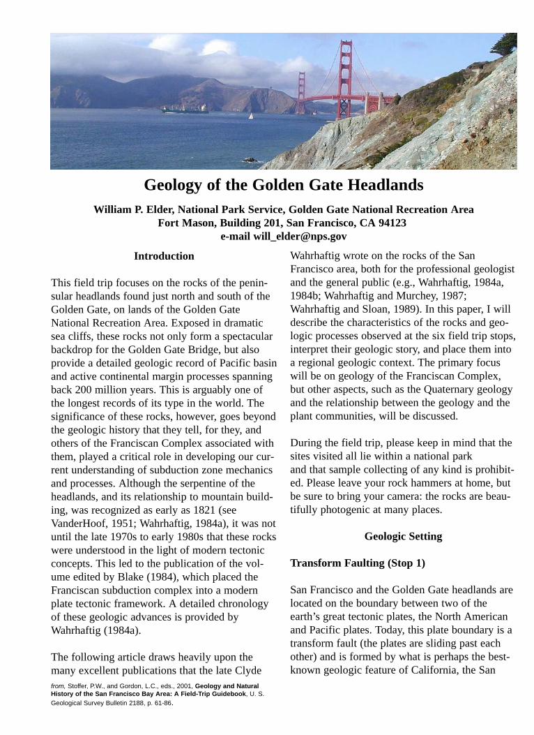
Andreas fault zone. Movement, totaling about 1inch (2.5 cm) a year, along the San Andreas andits subsidiary faults, the Hayward and Calavaras(Figure 1), is infamous for producing the largeearthquakes that periodically rock California andalso results the area’s youthful and beautifullyrugged terrain. Major earthquakes occur severaltimes each century on these or less well-knownfaults in the San Francisco Bay Area, releasingstrain built up between the creeping plates.
In the Bay Area, the current mountains of theCalifornia Coast Ranges, the Santa CruzMountains and the Diablo Range, started to upliftonly about 3 to 4 million years ago (Page, 1989),when pressure increased across the plate boundarydue to a slight shift in relative plate motions (Coxand Engebretsen, 1985); this same shift caused theIsthmus of Panama to rise from the sea and con-nect North and South America. The Santa CruzMountains are forming where the San Andreasfault makes a slight bend to the left. This bendproduces compression, folding and thrust faultingat the plate boundary, as the Pacific Plate tries toslide northward past the North American Plate. Incontrast, valleys between the ranges, such as theSan Francisco Bay – Santa Clara Valley, lie in sta-ble or slowly down-dropping areas formedbetween the major faults, in this case the San
Andreas, Hayward and Calavaras faults (Figure 1)(Page, 1989).
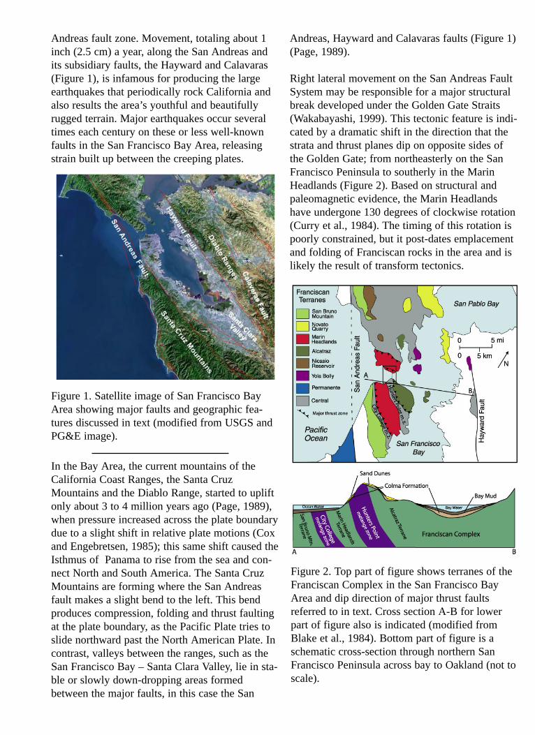
Right lateral movement on the San Andreas FaultSystem may be responsible for a major structuralbreak developed under the Golden Gate Straits(Wakabayashi, 1999). This tectonic feature is indi-cated by a dramatic shift in the direction that thestrata and thrust planes dip on opposite sides ofthe Golden Gate; from northeasterly on the SanFrancisco Peninsula to southerly in the MarinHeadlands (Figure 2). Based on structural andpaleomagnetic evidence, the Marin Headlandshave undergone 130 degrees of clockwise rotation(Curry et al., 1984). The timing of this rotation ispoorly constrained, but it post-dates emplacementand folding of Franciscan rocks in the area and islikely the result of transform tectonics.
Figure 1. Satellite image of San Francisco BayArea showing major faults and geographic fea-tures discussed in text (modified from USGS andPG&E image).
Figure 2. Top part of figure shows terranes of theFranciscan Complex in the San Francisco BayArea and dip direction of major thrust faultsreferred to in text. Cross section A-B for lowerpart of figure also is indicated (modified fromBlake et al., 1984). Bottom part of figure is aschematic cross-section through northern SanFrancisco Peninsula across bay to Oakland (not toscale).
Making San Francisco Bay (Stop 1)
Although the valley in which San Francisco Bayresides probably began to form 2 to 3 millionyears ago, when the surrounding mountains andhills started to rise on either side, the first knownestuarine (marine influenced) rocks were laiddown only about 600,000 years ago, as dated bythe Rockland ash bed which overlies the earliestmarine rocks (Sarna-Wojcicki; pers. comm.,2001). Cores taken during bridge-foundation stud-ies and construction record up to seven differentestuarine periods over the last half million years,corresponding to times of high sea level duringinterglacial periods (Atwater, et al., 1977; Sloan,1989). During the glacial periods, when vastquantities of ocean water were stored in continen-tal glaciers, the bay floor became a valley andexperienced erosion and down-cutting. At thosetimes, the huge, glacial-fed ancestral SacramentoRiver flowed through the bay valley and out theGolden Gate Straits. Ocean water started floodinginto the present San Francisco Bay only about8,000 years ago, when the sea reentered theGolden Gate following the last glaciation(Wisconsin).
The Franciscan Complex (Stops 2 to 6)
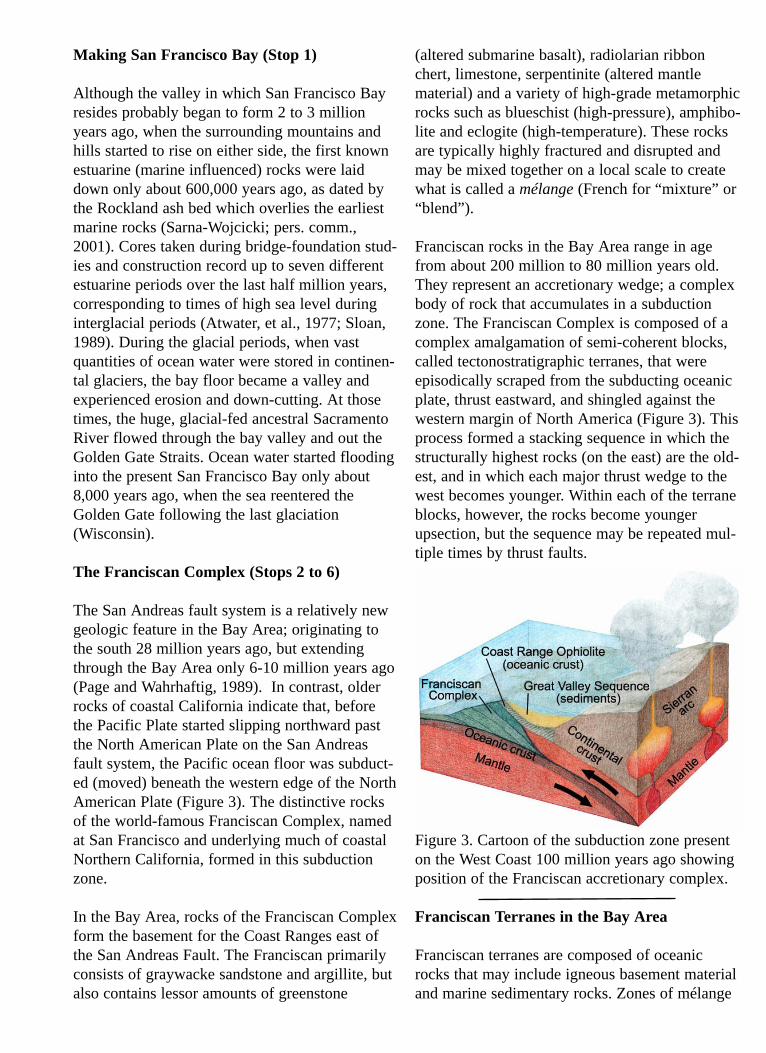
The San Andreas fault system is a relatively newgeologic feature in the Bay Area; originating tothe south 28 million years ago, but extendingthrough the Bay Area only 6-10 million years ago(Page and Wahrhaftig, 1989). In contrast, olderrocks of coastal California indicate that, beforethe Pacific Plate started slipping northward pastthe North American Plate on the San Andreasfault system, the Pacific ocean floor was subduct-ed (moved) beneath the western edge of the NorthAmerican Plate (Figure 3). The distinctive rocksof the world-famous Franciscan Complex, namedat San Francisco and underlying much of coastalNorthern California, formed in this subductionzone.
In the Bay Area, rocks of the Franciscan Complexform the basement for the Coast Ranges east ofthe San Andreas Fault. The Franciscan primarilyconsists of graywacke sandstone and argillite, butalso contains lessor amounts of greenstone
(altered submarine basalt), radiolarian ribbonchert, limestone, serpentinite (altered mantlematerial) and a variety of high-grade metamorphicrocks such as blueschist (high-pressure), amphibo-lite and eclogite (high-temperature). These rocksare typically highly fractured and disrupted andmay be mixed together on a local scale to createwhat is called a mélange (French for “mixture” or“blend”).
Franciscan rocks in the Bay Area range in agefrom about 200 million to 80 million years old.They represent an accretionary wedge; a complexbody of rock that accumulates in a subductionzone. The Franciscan Complex is composed of acomplex amalgamation of semi-coherent blocks,called tectonostratigraphic terranes, that wereepisodically scraped from the subducting oceanicplate, thrust eastward, and shingled against thewestern margin of North America (Figure 3). Thisprocess formed a stacking sequence in which thestructurally highest rocks (on the east) are the old-est, and in which each major thrust wedge to thewest becomes younger. Within each of the terraneblocks, however, the rocks become youngerupsection, but the sequence may be repeated mul-tiple times by thrust faults.
Figure 3. Cartoon of the subduction zone presenton the West Coast 100 million years ago showingposition of the Franciscan accretionary complex.
Franciscan Terranes in the Bay Area
Franciscan terranes are composed of oceanicrocks that may include igneous basement materialand marine sedimentary rocks. Zones of mélange
separate the terranes. In the Bay area, theFranciscan Complex is divided into the Easternand the Central belts, with the older Eastern beltlying structurally higher and being of highermetamorphic grade than the Central belt (Blake etal., 1984). This field trip will focus on CentralBelt rocks, which Blake et al. (1984) divided intoeight terranes in the Bay Area (Figure 2). Thisdivision is based on differences in basement typesand ages, in the age and types of overlying sedi-mentary sequences, and in their metamorphicgrade.
San Francisco and the Marin Headlands containthree of these terranes, from oldest to youngest,the Alcatraz, Marin Headlands, and San BrunoMountain terranes. Separating the terranes are theHunters Point and City College mélange zones,which are primarily composed of sheared serpen-tinite and shale with scattered blocks of green-stone, chert, graywacke, and high-grade metamor-phics (Figure 2). The Alcatraz Terrane is charac-terized by graywacke turbidite deposits containingfossils indicating that the sediments were deposit-
ed between 130 and 140 million years ago (EarlyCretaceous) (Blake et al., 1984, Elder, 1998). TheMarin Headlands Terrane, which is discussed inmore detail below, contains an oceanic sequenceincluding basaltic crust covered by open-oceanchert deposits and overlying continental-derivedsandstone. Fossils in these units indicate that thechert was deposited from about 200 million to100 million years ago (Early Jurassic to LateCretaceous) and the sandstone between 100 and90 million years ago (Murchey and Jones, 1984).The San Bruno Mountain Terrane is composedpredominately of sandstone and has yielded nofossils. Although its age is unknown, the block isthought to be Late Cretaceous in age, based on itsposition west of the Marin Headlands Terrane(Figure 2).
Marin Headlands Terrane
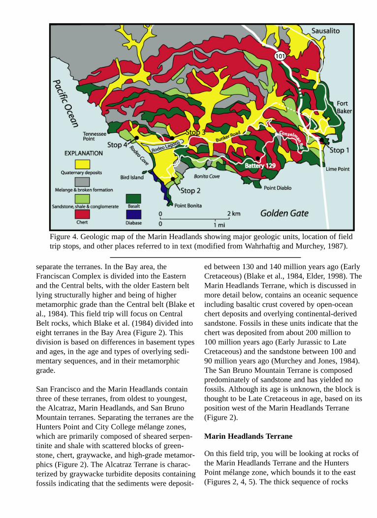
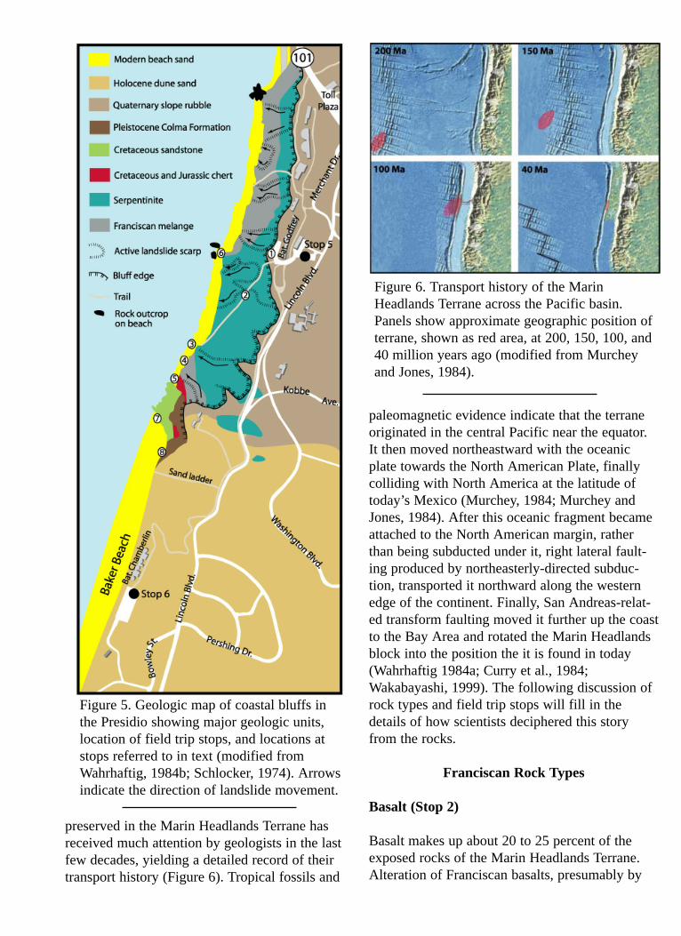
On this field trip, you will be looking at rocks ofthe Marin Headlands Terrane and the HuntersPoint mélange zone, which bounds it to the east(Figures 2, 4, 5). The thick sequence of rocks
Figure 4. Geologic map of the Marin Headlands showing major geologic units, location of fieldtrip stops, and other places referred to in text (modified from Wahrhaftig and Murchey, 1987).
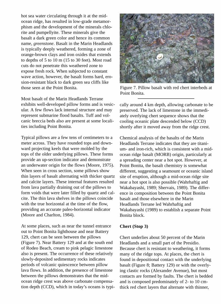
preserved in the Marin Headlands Terrane hasreceived much attention by geologists in the last few decades, yielding a detailed record of theirtransport history (Figure 6). Tropical fossils and
paleomagnetic evidence indicate that the terraneoriginated in the central Pacific near the equator.It then moved northeastward with the oceanicplate towards the North American Plate, finallycolliding with North America at the latitude oftoday’s Mexico (Murchey, 1984; Murchey andJones, 1984). After this oceanic fragment becameattached to the North American margin, ratherthan being subducted under it, right lateral fault-ing produced by northeasterly-directed subduc-tion, transported it northward along the westernedge of the continent. Finally, San Andreas-relat-ed transform faulting moved it further up the coastto the Bay Area and rotated the Marin Headlandsblock into the position the it is found in today(Wahrhaftig 1984a; Curry et al., 1984;Wakabayashi, 1999). The following discussion ofrock types and field trip stops will fill in thedetails of how scientists deciphered this storyfrom the rocks.
Franciscan Rock Types
Basalt (Stop 2)
Basalt makes up about 20 to 25 percent of theexposed rocks of the Marin Headlands Terrane.Alteration of Franciscan basalts, presumably by
Figure 5. Geologic map of coastal bluffs inthe Presidio showing major geologic units,location of field trip stops, and locations atstops referred to in text (modified fromWahrhaftig, 1984b; Schlocker, 1974). Arrowsindicate the direction of landslide movement.
Figure 6. Transport history of the MarinHeadlands Terrane across the Pacific basin.Panels show approximate geographic position ofterrane, shown as red area, at 200, 150, 100, and40 million years ago (modified from Murcheyand Jones, 1984).
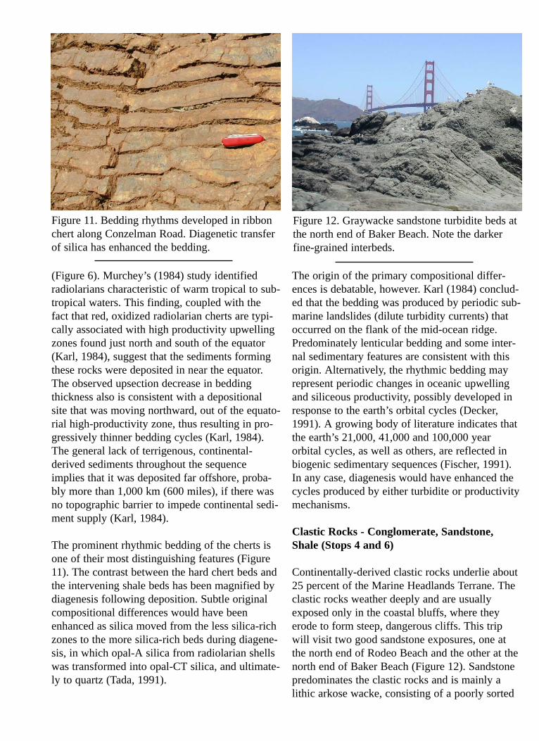
hot sea water circulating through it at the mid-ocean ridge, has resulted in low-grade metamor-phism and the development of the minerals chlo-rite and pumpellyite. These minerals give thebasalt a dark green color and hence its commonname, greenstone. Basalt in the Marin Headlandsis typically deeply weathered, forming a zone oforange-brown clays and iron oxides that extendsto depths of 5 to 10 m (15 to 30 feet). Most roadcuts do not penetrate this weathered zone toexpose fresh rock. When subjected to constantwave action, however, the basalt forms hard, ero-sion-resistant black to dark green sea cliffs likethose seen at the Point Bonita.
Most basalt of the Marin Headlands Terraneexhibits well-developed pillow forms and is vesic-ular. A few flows lack internal structure and mayrepresent submarine flood basalts. Tuff and vol-canic breccia beds also are present at some locali-ties including Point Bonita.
Typical pillows are a few tens of centimeters to ameter across. They have rounded tops and down-ward projecting keels that were molded by thetops of the older underlying pillows. These formsprovide an up-section indicator and demonstratean underwater origin for the flows (Moore, 1975).When seen in cross section, some pillows showthin layers of basalt alternating with thicker quartzand calcite layers. These internal features resultedfrom lava partially draining out of the pillows toform voids that were later filled by quartz and cal-cite. The thin lava shelves in the pillows coincidewith the true horizontal at the time of the flow,providing an accurate paleo-horizontal indicator(Moore and Charlton, 1984).
At some places, such as near the tunnel entranceout to Point Bonita lighthouse and near Battery129, chert can be seen between the pillows(Figure 7). Near Battery 129 and at the south endof Rodeo Beach, cream to pink pelagic limestonealso is present. The occurrence of these relativelyslowly-deposited sedimentary rocks indicatesperiods of volcanic quiescence between pillowlava flows. In addition, the presence of limestonebetween the pillows demonstrates that the mid-ocean ridge crest was above carbonate compensa-tion depth (CCD), which in today’s oceans is typi-
cally around 4 km depth, allowing carbonate to bepreserved. The lack of limestone in the immedi-ately overlying chert sequence shows that thecooling oceanic plate descended below (CCD)shortly after it moved away from the ridge crest.
Chemical analysis of the basalts of the MarinHeadlands Terrane indicates that they are titani-um- and iron-rich, which is consistent with a mid-ocean ridge basalt (MORB) origin, particularly ata spreading center near a hot spot. However, atPoint Bonita, the basalt chemistry is somewhatdifferent, suggesting a seamount or oceanic islandsite of eruption, although a mid-ocean ridge sitenear a hot spot is also possible (Wahrhaftig andWakabayashi, 1989; Shervais, 1989). The differ-ence in composition between the Point Bonitabasalt and those elsewhere in the MarinHeadlands Terrane led Wahrhaftig andWakabayashi (1989) to establish a separate PointBonita block.
Chert (Stop 3)
Chert underlies about 50 percent of the MarinHeadlands and a small part of the Presidio.Because chert is resistant to weathering, it formsmany of the ridge tops. At places, the chert isfound in depositional contact with the underlyingbasalt (Figure 8; Battery 129) or with the overly-ing clastic rocks (Alexander Avenue), but mostcontacts are formed by faults. The chert is beddedand is composed predominately of 2- to 10 cm-thick red chert layers that alternate with thinner,
Figure 7. Pillow basalt with red chert interbeds atPoint Bonita.

dark red shale beds. The red color indicates theoxidized state of the iron in this siliceous rock.Light green to white chert beds also are present,but are much less common and occur in the midto upper parts of the section. In general, the bed-ding thickness decreases and the shale contentincreases upsection. Because of the prominentthin bedding, these rocks are commonly calledribbon chert. Chert lying near the basalt contacthas a silvery gray to black manganese oxide stain-ing. This manganese is probably related to bothhydrothermal and hydrogenous Mn associatedwith the spreading ridge (Karl, 1984).
Locally, the chert is intensely folded, formingcomplex sharp-crested chevron and isoclinal folds(Figure 9). Such folding is well exposed alongConzelman Road. Most likely, the foldingoccurred when the Marin Headlands Terrane waswedged against the continental margin and subse-quently faulted to its present position. However,abrupt changes from only slightly deformedsequences to highly folded areas, and unbrokensharply folded beds, have led to speculation thatsome of the contorted folding reflects submarineslumping on the flank of the mid-ocean ridgeprior to final hardening of the layers (Bailey et al.,1964; Wahrhaftig, 1984a).
The chert of the Marine Headlands contains abun-dant radiolarian fossils that are silt to sand sizeand that are clearly visible with a hand lens.These tiny siliceous fossil shells provided much
of the silica content in these beds. The radiolariacan be extracted from the rock with hydroflouricacid, providing spectacular three-dimensional fos-sils (Figure 10). By studying these fossils,Murchey (1984) determined that the oldest chertsdeposited on the basalt contain species that livedabout 200 million years ago (Early Jurassic,Pliensbachian Stage), and that the youngestspecies, at the top of the section near the sand-stones, lived about 100 million years ago(Cretaceous, Albian to Cenomanian stages). Thechert sequence, therefore, reflects 100 millionyears of pelagic deposition and is one of thelongest stratigraphic sequences of chert in theworld (Wahrhaftig and Murchey, 1987).
The cherts contain a number of features indicatingthat they formed in the equatorial central Pacific
Figure 8. Ribbon chert in depositional contactwith pillow basalt at Battery 129.
Figure 9. Folded chert beds on Conzelman Road.Note the lack of fracturing on the tight folds.
Figure 10. Scanning electron micrographs of sili-ca tests (shells) of Radiolaria removed from theMarin Headlands chert by using hydroflouric acid(from Murchey, 1984).
(Figure 6). Murchey’s (1984) study identifiedradiolarians characteristic of warm tropical to sub-tropical waters. This finding, coupled with thefact that red, oxidized radiolarian cherts are typi-cally associated with high productivity upwellingzones found just north and south of the equator(Karl, 1984), suggest that the sediments formingthese rocks were deposited in near the equator.The observed upsection decrease in beddingthickness also is consistent with a depositionalsite that was moving northward, out of the equato-rial high-productivity zone, thus resulting in pro-gressively thinner bedding cycles (Karl, 1984).The general lack of terrigenous, continental-derived sediments throughout the sequenceimplies that it was deposited far offshore, proba-bly more than 1,000 km (600 miles), if there wasno topographic barrier to impede continental sedi-ment supply (Karl, 1984).
The prominent rhythmic bedding of the cherts isone of their most distinguishing features (Figure11). The contrast between the hard chert beds andthe intervening shale beds has been magnified bydiagenesis following deposition. Subtle originalcompositional differences would have beenenhanced as silica moved from the less silica-richzones to the more silica-rich beds during diagene-sis, in which opal-A silica from radiolarian shellswas transformed into opal-CT silica, and ultimate-ly to quartz (Tada, 1991).
The origin of the primary compositional differ-ences is debatable, however. Karl (1984) conclud-ed that the bedding was produced by periodic sub-marine landslides (dilute turbidity currents) thatoccurred on the flank of the mid-ocean ridge.Predominately lenticular bedding and some inter-nal sedimentary features are consistent with thisorigin. Alternatively, the rhythmic bedding mayrepresent periodic changes in oceanic upwellingand siliceous productivity, possibly developed inresponse to the earth’s orbital cycles (Decker,1991). A growing body of literature indicates thatthe earth’s 21,000, 41,000 and 100,000 yearorbital cycles, as well as others, are reflected inbiogenic sedimentary sequences (Fischer, 1991).In any case, diagenesis would have enhanced thecycles produced by either turbidite or productivitymechanisms.
Clastic Rocks - Conglomerate, Sandstone,Shale (Stops 4 and 6)
Continentally-derived clastic rocks underlie about25 percent of the Marine Headlands Terrane. Theclastic rocks weather deeply and are usuallyexposed only in the coastal bluffs, where theyerode to form steep, dangerous cliffs. This tripwill visit two good sandstone exposures, one atthe north end of Rodeo Beach and the other at thenorth end of Baker Beach (Figure 12). Sandstonepredominates the clastic rocks and is mainly alithic arkose wacke, consisting of a poorly sorted
Figure 11. Bedding rhythms developed in ribbonchert along Conzelman Road. Diagenetic transferof silica has enhanced the bedding.
Figure 12. Graywacke sandstone turbidite beds atthe north end of Baker Beach. Note the darkerfine-grained interbeds.
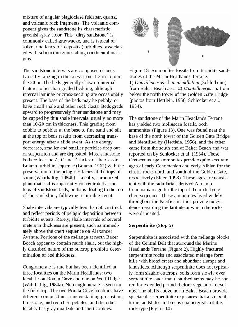
mixture of angular plagioclase feldspar, quartz,and volcanic rock fragments. The volcanic com-ponent gives the sandstone its characteristicgreenish-gray color. This “dirty sandstone” iscommonly called graywacke, and is typical ofsubmarine landslide deposits (turbidites) associat-ed with subduction zones along continental mar-gins.
The sandstone intervals are composed of bedstypically ranging in thickness from 1-2 m to morethe 20 m. The beds generally show no internalfeatures other than graded bedding, althoughinternal laminae or cross-bedding are occasionallypresent. The base of the beds may be pebbly, orhave small shale and other rock clasts. Beds gradeupward to progressively finer sandstone and maybe capped by thin shale intervals, usually no morethan 10-20 cm in thickness. This grading fromcobble to pebbles at the base to fine sand and siltat the top of beds results from decreasing trans-port energy after a slide event. As the energydecreases, smaller and smaller particles drop outof suspension and are deposited. Most sandstonebeds reflect the A, C and D facies of the classicBouma turbidite sequence (Bouma, 1962) with thepreservation of the pelagic E facies at the tops ofsome (Wahrhaftig, 1984b). Locally, carbonizedplant material is apparently concentrated at thetops of sandstone beds, perhaps floating to the topof the sand slurry following a turbidite event.
Shale intervals are typically less than 50 cm thickand reflect periods of pelagic deposition betweenturbidite events. Rarely, shale intervals of severalmeters in thickness are present, such as immedi-ately above the chert sequence on AlexanderAvenue. Portions of the mélange at north BakerBeach appear to contain much shale, but the high-ly disturbed nature of the outcrop prohibits deter-mination of bed thickness.
Conglomerate is rare but has been identified atthree localities on the Marin Headlands: twolocalities at Bonita Cove and one on Wolf Ridge(Wahrhaftig, 1984a). No conglomerate is seen onthe field trip. The two Bonita Cove localities havedifferent compositions, one containing greenstone,limestone, and red chert pebbles, and the otherlocality has gray quartzite and chert cobbles.
The sandstone of the Marin Headlands Terranehas yielded two molluscan fossils, bothammonites (Figure 13). One was found near thebase of the north tower of the Golden Gate Bridgeand identified by (Hertlein, 1956), and the othercame from the south end of Baker Beach and wasreported on by Schlocker et al. (1954). TheseCretaceous age ammonites provide quite accurateages of early Cenomanian and early Albian for theclastic rocks north and south of the Golden Gate,respectively (Elder, 1998). These ages are consis-tent with the radiolarian-derived Albian toCenomanian age for the top of the underlyingchert sequence. These ammonites lived widelythroughout the Pacific and thus provide no evi-dence regarding the latitude at which the rockswere deposited.
Serpentinite (Stop 5)
Serpentinite is associated with the mélange blocksof the Central Belt that surround the MarineHeadlands Terrane (Figure 2). Highly fracturedserpentinite rocks and associated mélange formhills with broad crests and abundant slumps andlandslides. Although serpentinite does not typical-ly form sizable outcrops, soils form slowly overserpentinite, such that disturbed areas may be bar-ren for extended periods before vegetation devel-ops. The bluffs above north Baker Beach providespectacular serpentinite exposures that also exhib-it the landslides and seeps characteristic of thisrock type (Figure 14).
Figure 13. Ammonites fossils from turbidite sand-stones of the Marin Headlands Terrane. 1) Douvilleiceras cf. mammillatum (Schlotheim)from Baker Beach area. 2) Mantelliceras sp. frombelow the north tower of the Golden Gate Bridge(photos from Hertlein, 1956; Schlocker et al.,1954).
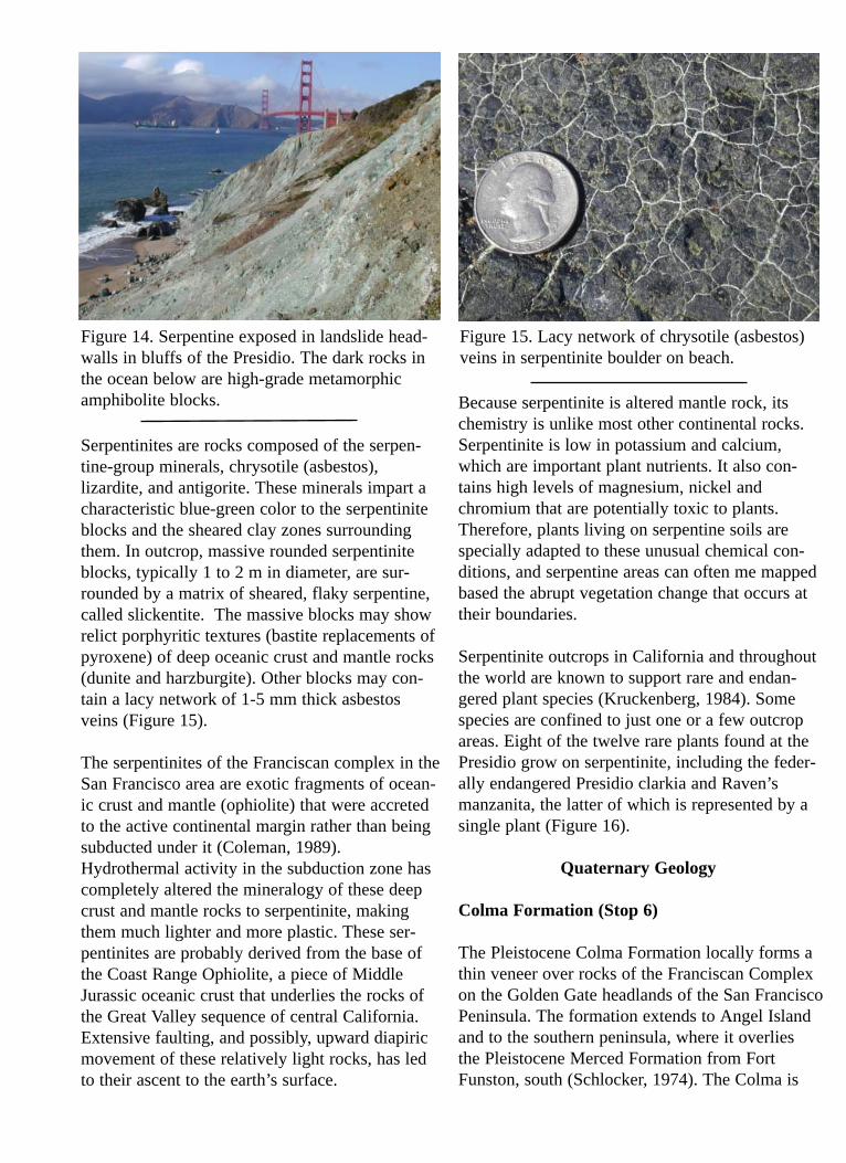
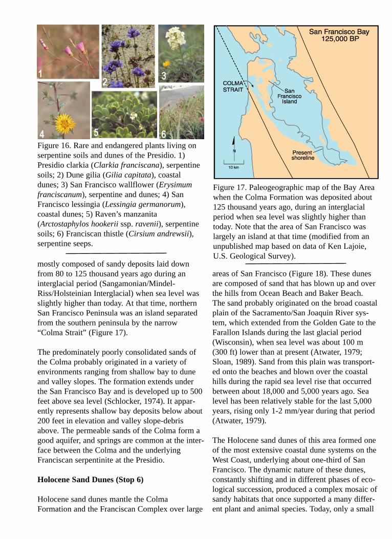
Serpentinites are rocks composed of the serpen-tine-group minerals, chrysotile (asbestos),lizardite, and antigorite. These minerals impart acharacteristic blue-green color to the serpentiniteblocks and the sheared clay zones surroundingthem. In outcrop, massive rounded serpentiniteblocks, typically 1 to 2 m in diameter, are sur-rounded by a matrix of sheared, flaky serpentine,called slickentite. The massive blocks may showrelict porphyritic textures (bastite replacements ofpyroxene) of deep oceanic crust and mantle rocks(dunite and harzburgite). Other blocks may con-tain a lacy network of 1-5 mm thick asbestos veins (Figure 15).
The serpentinites of the Franciscan complex in theSan Francisco area are exotic fragments of ocean-ic crust and mantle (ophiolite) that were accretedto the active continental margin rather than beingsubducted under it (Coleman, 1989).Hydrothermal activity in the subduction zone hascompletely altered the mineralogy of these deepcrust and mantle rocks to serpentinite, makingthem much lighter and more plastic. These ser-pentinites are probably derived from the base ofthe Coast Range Ophiolite, a piece of MiddleJurassic oceanic crust that underlies the rocks ofthe Great Valley sequence of central California.Extensive faulting, and possibly, upward diapiricmovement of these relatively light rocks, has ledto their ascent to the earth’s surface.
Because serpentinite is altered mantle rock, itschemistry is unlike most other continental rocks.Serpentinite is low in potassium and calcium,which are important plant nutrients. It also con-tains high levels of magnesium, nickel andchromium that are potentially toxic to plants.Therefore, plants living on serpentine soils arespecially adapted to these unusual chemical con-ditions, and serpentine areas can often me mappedbased the abrupt vegetation change that occurs attheir boundaries.
Serpentinite outcrops in California and throughoutthe world are known to support rare and endan-gered plant species (Kruckenberg, 1984). Somespecies are confined to just one or a few outcropareas. Eight of the twelve rare plants found at thePresidio grow on serpentinite, including the feder-ally endangered Presidio clarkia and Raven’smanzanita, the latter of which is represented by asingle plant (Figure 16).
Quaternary Geology
Colma Formation (Stop 6)
The Pleistocene Colma Formation locally forms athin veneer over rocks of the Franciscan Complexon the Golden Gate headlands of the San FranciscoPeninsula. The formation extends to Angel Islandand to the southern peninsula, where it overliesthe Pleistocene Merced Formation from FortFunston, south (Schlocker, 1974). The Colma is
Figure 14. Serpentine exposed in landslide head-walls in bluffs of the Presidio. The dark rocks inthe ocean below are high-grade metamorphicamphibolite blocks.
Figure 15. Lacy network of chrysotile (asbestos)veins in serpentinite boulder on beach.
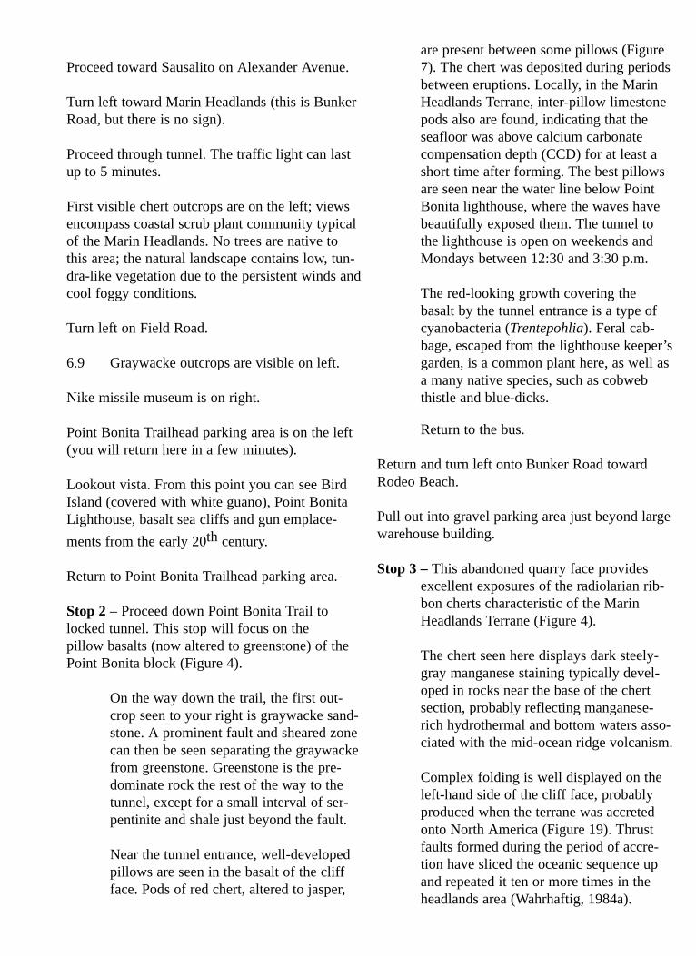
mostly composed of sandy deposits laid downfrom 80 to 125 thousand years ago during aninterglacial period (Sangamonian/Mindel-Riss/Holsteinian Interglacial) when sea level wasslightly higher than today. At that time, northernSan Francisco Peninsula was an island separatedfrom the southern peninsula by the narrow“Colma Strait” (Figure 17).
The predominately poorly consolidated sands ofthe Colma probably originated in a variety ofenvironments ranging from shallow bay to duneand valley slopes. The formation extends underthe San Francisco Bay and is developed up to 500feet above sea level (Schlocker, 1974). It appar-ently represents shallow bay deposits below about200 feet in elevation and valley slope-debrisabove. The permeable sands of the Colma form agood aquifer, and springs are common at the inter-face between the Colma and the underlyingFranciscan serpentinite at the Presidio.
Holocene Sand Dunes (Stop 6)
Holocene sand dunes mantle the ColmaFormation and the Franciscan Complex over large
areas of San Francisco (Figure 18). These dunesare composed of sand that has blown up and overthe hills from Ocean Beach and Baker Beach.The sand probably originated on the broad coastalplain of the Sacramento/San Joaquin River sys-tem, which extended from the Golden Gate to theFarallon Islands during the last glacial period(Wisconsin), when sea level was about 100 m(300 ft) lower than at present (Atwater, 1979;Sloan, 1989). Sand from this plain was transport-ed onto the beaches and blown over the coastalhills during the rapid sea level rise that occurredbetween about 18,000 and 5,000 years ago. Sealevel has been relatively stable for the last 5,000years, rising only 1-2 mm/year during that period(Atwater, 1979).
The Holocene sand dunes of this area formed oneof the most extensive coastal dune systems on theWest Coast, underlying about one-third of SanFrancisco. The dynamic nature of these dunes,constantly shifting and in different phases of eco-logical succession, produced a complex mosaic ofsandy habitats that once supported a many differ-ent plant and animal species. Today, only a small
Figure 16. Rare and endangered plants living onserpentine soils and dunes of the Presidio. 1)Presidio clarkia (Clarkia franciscana), serpentinesoils; 2) Dune gilia (Gilia capitata), coastaldunes; 3) San Francisco wallflower (Erysimumfranciscanum), serpentine and dunes; 4) SanFrancisco lessingia (Lessingia germanorum),coastal dunes; 5) Raven’s manzanita(Arctostaphylos hookerii ssp. ravenii), serpentinesoils; 6) Franciscan thistle (Cirsium andrewsii),serpentine seeps.
Figure 17. Paleogeographic map of the Bay Areawhen the Colma Formation was deposited about125 thousand years ago, during an interglacialperiod when sea level was slightly higher thantoday. Note that the area of San Francisco waslargely an island at that time (modified from anunpublished map based on data of Ken Lajoie,U.S. Geological Survey).
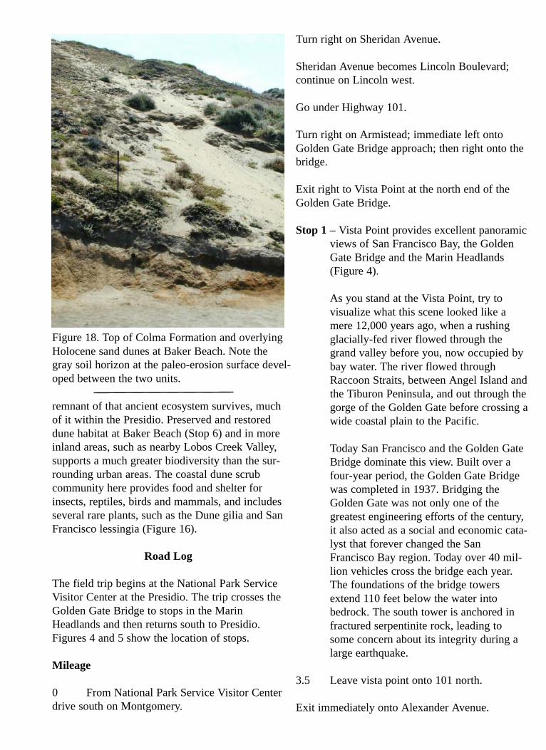
remnant of that ancient ecosystem survives, muchof it within the Presidio. Preserved and restoreddune habitat at Baker Beach (Stop 6) and in moreinland areas, such as nearby Lobos Creek Valley,supports a much greater biodiversity than the sur-rounding urban areas. The coastal dune scrubcommunity here provides food and shelter forinsects, reptiles, birds and mammals, and includesseveral rare plants, such as the Dune gilia and SanFrancisco lessingia (Figure 16).
Road Log
The field trip begins at the National Park ServiceVisitor Center at the Presidio. The trip crosses theGolden Gate Bridge to stops in the MarinHeadlands and then returns south to Presidio.Figures 4 and 5 show the location of stops.
Mileage
0 From National Park Service Visitor Centerdrive south on Montgomery.
Turn right on Sheridan Avenue.
Sheridan Avenue becomes Lincoln Boulevard;continue on Lincoln west.
Go under Highway 101.
Turn right on Armistead; immediate left ontoGolden Gate Bridge approach; then right onto thebridge.
Exit right to Vista Point at the north end of theGolden Gate Bridge.
Stop 1 – Vista Point provides excellent panoramicviews of San Francisco Bay, the GoldenGate Bridge and the Marin Headlands(Figure 4).
As you stand at the Vista Point, try tovisualize what this scene looked like amere 12,000 years ago, when a rushingglacially-fed river flowed through thegrand valley before you, now occupied bybay water. The river flowed throughRaccoon Straits, between Angel Island andthe Tiburon Peninsula, and out through thegorge of the Golden Gate before crossing awide coastal plain to the Pacific.
Today San Francisco and the Golden GateBridge dominate this view. Built over afour-year period, the Golden Gate Bridgewas completed in 1937. Bridging theGolden Gate was not only one of thegreatest engineering efforts of the century,it also acted as a social and economic cata-lyst that forever changed the SanFrancisco Bay region. Today over 40 mil-lion vehicles cross the bridge each year.The foundations of the bridge towersextend 110 feet below the water intobedrock. The south tower is anchored infractured serpentinite rock, leading tosome concern about its integrity during alarge earthquake.
3.5 Leave vista point onto 101 north.
Exit immediately onto Alexander Avenue.
Figure 18. Top of Colma Formation and overlyingHolocene sand dunes at Baker Beach. Note thegray soil horizon at the paleo-erosion surface devel-oped between the two units.
Proceed toward Sausalito on Alexander Avenue.
Turn left toward Marin Headlands (this is BunkerRoad, but there is no sign).
Proceed through tunnel. The traffic light can lastup to 5 minutes.
First visible chert outcrops are on the left; viewsencompass coastal scrub plant community typicalof the Marin Headlands. No trees are native tothis area; the natural landscape contains low, tun-dra-like vegetation due to the persistent winds andcool foggy conditions.
Turn left on Field Road.
6.9 Graywacke outcrops are visible on left.
Nike missile museum is on right.
Point Bonita Trailhead parking area is on the left(you will return here in a few minutes).
Lookout vista. From this point you can see BirdIsland (covered with white guano), Point BonitaLighthouse, basalt sea cliffs and gun emplace-ments from the early 20th century.
Return to Point Bonita Trailhead parking area.
Stop 2 – Proceed down Point Bonita Trail tolocked tunnel. This stop will focus on thepillow basalts (now altered to greenstone) of thePoint Bonita block (Figure 4).
On the way down the trail, the first out-crop seen to your right is graywacke sand-stone. A prominent fault and sheared zonecan then be seen separating the graywackefrom greenstone. Greenstone is the pre-dominate rock the rest of the way to thetunnel, except for a small interval of ser-pentinite and shale just beyond the fault.
Near the tunnel entrance, well-developedpillows are seen in the basalt of the cliffface. Pods of red chert, altered to jasper,
are present between some pillows (Figure7). The chert was deposited during periodsbetween eruptions. Locally, in the MarinHeadlands Terrane, inter-pillow limestonepods also are found, indicating that theseafloor was above calcium carbonatecompensation depth (CCD) for at least ashort time after forming. The best pillowsare seen near the water line below PointBonita lighthouse, where the waves havebeautifully exposed them. The tunnel tothe lighthouse is open on weekends andMondays between 12:30 and 3:30 p.m.
The red-looking growth covering thebasalt by the tunnel entrance is a type ofcyanobacteria (Trentepohlia). Feral cab-bage, escaped from the lighthouse keeper’sgarden, is a common plant here, as well asa many native species, such as cobwebthistle and blue-dicks.
Return to the bus.
Return and turn left onto Bunker Road towardRodeo Beach.
Pull out into gravel parking area just beyond largewarehouse building.
Stop 3 – This abandoned quarry face providesexcellent exposures of the radiolarian rib-bon cherts characteristic of the MarinHeadlands Terrane (Figure 4).
The chert seen here displays dark steely-gray manganese staining typically devel-oped in rocks near the base of the chertsection, probably reflecting manganese-rich hydrothermal and bottom waters asso-ciated with the mid-ocean ridge volcanism.
Complex folding is well displayed on theleft-hand side of the cliff face, probablyproduced when the terrane was accretedonto North America (Figure 19). Thrustfaults formed during the period of accre-tion have sliced the oceanic sequence upand repeated it ten or more times in theheadlands area (Wahrhaftig, 1984a).
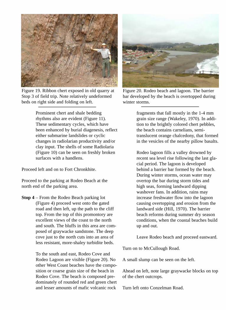
Prominent chert and shale beddingrhythms also are evident (Figure 11).These sedimentary cycles, which havebeen enhanced by burial diagenesis, reflecteither submarine landslides or cyclicchanges in radiolarian productivity and/orclay input. The shells of some Radiolaria(Figure 10) can be seen on freshly brokensurfaces with a handlens.
Proceed left and on to Fort Chronkhite.
Proceed to the parking at Rodeo Beach at thenorth end of the parking area.
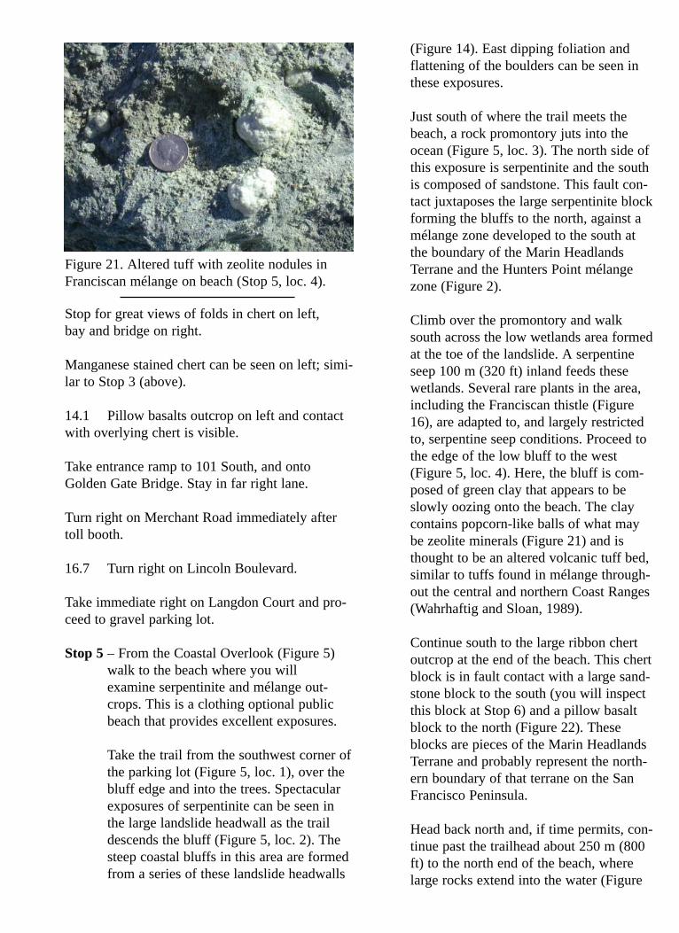
Stop 4 – From the Rodeo Beach parking lot(Figure 4) proceed west onto the gatedroad and then left, up the path to the clifftop. From the top of this promontory areexcellent views of the coast to the northand south. The bluffs in this area are com-posed of graywacke sandstone. The deepcove just to the north cuts into an area ofless resistant, more-shaley turbidite beds.
To the south and east, Rodeo Cove andRodeo Lagoon are visible (Figure 20). Noother West Coast beaches have the compo-sition or coarse grain size of the beach inRodeo Cove. The beach is composed pre-dominately of rounded red and green chertand lesser amounts of mafic volcanic rock
fragments that fall mostly in the 1-4 mmgrain size range (Wakeley, 1970). In addi-tion to the brightly colored chert pebbles,the beach contains carnelians, semi-translucent orange chalcedony, that formedin the vesicles of the nearby pillow basalts.
Rodeo lagoon fills a valley drowned byrecent sea level rise following the last gla-cial period. The lagoon is developedbehind a barrier bar formed by the beach.During winter storms, ocean water mayovertop the bar during storm tides andhigh seas, forming landward dippingwashover fans. In addition, rains mayincrease freshwater flow into the lagooncausing overtopping and erosion from thelandward side (Hill, 1970). The barrierbeach reforms during summer dry seasonconditions, when the coastal beaches buildup and out.
Leave Rodeo beach and proceed eastward.
Turn on to McCullough Road.
A small slump can be seen on the left.
Ahead on left, note large graywacke blocks on topof the chert outcrops.
Turn left onto Conzelman Road.
Figure 19. Ribbon chert exposed in old quarry atStop 3 of field trip. Note relatively undeformedbeds on right side and folding on left.
Figure 20. Rodeo beach and lagoon. The barrierbar developed by the beach is overtopped duringwinter storms.
Stop for great views of folds in chert on left,bay and bridge on right.
Manganese stained chert can be seen on left; simi-lar to Stop 3 (above).
14.1 Pillow basalts outcrop on left and contactwith overlying chert is visible.
Take entrance ramp to 101 South, and ontoGolden Gate Bridge. Stay in far right lane.
Turn right on Merchant Road immediately aftertoll booth.
16.7 Turn right on Lincoln Boulevard.
Take immediate right on Langdon Court and pro-ceed to gravel parking lot.
Stop 5 – From the Coastal Overlook (Figure 5)walk to the beach where you willexamine serpentinite and mélange out-crops. This is a clothing optional publicbeach that provides excellent exposures.
Take the trail from the southwest corner ofthe parking lot (Figure 5, loc. 1), over thebluff edge and into the trees. Spectacularexposures of serpentinite can be seen inthe large landslide headwall as the traildescends the bluff (Figure 5, loc. 2). Thesteep coastal bluffs in this area are formedfrom a series of these landslide headwalls
(Figure 14). East dipping foliation andflattening of the boulders can be seen inthese exposures.
Just south of where the trail meets thebeach, a rock promontory juts into theocean (Figure 5, loc. 3). The north side ofthis exposure is serpentinite and the southis composed of sandstone. This fault con-tact juxtaposes the large serpentinite blockforming the bluffs to the north, against amélange zone developed to the south atthe boundary of the Marin HeadlandsTerrane and the Hunters Point mélangezone (Figure 2).
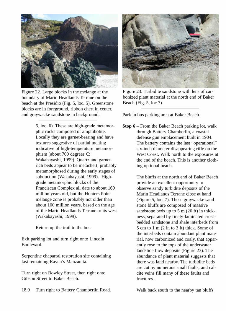
Climb over the promontory and walksouth across the low wetlands area formedat the toe of the landslide. A serpentineseep 100 m (320 ft) inland feeds thesewetlands. Several rare plants in the area,including the Franciscan thistle (Figure16), are adapted to, and largely restrictedto, serpentine seep conditions. Proceed tothe edge of the low bluff to the west(Figure 5, loc. 4). Here, the bluff is com-posed of green clay that appears to beslowly oozing onto the beach. The claycontains popcorn-like balls of what maybe zeolite minerals (Figure 21) and isthought to be an altered volcanic tuff bed,similar to tuffs found in mélange through-out the central and northern Coast Ranges(Wahrhaftig and Sloan, 1989).
Continue south to the large ribbon chertoutcrop at the end of the beach. This chertblock is in fault contact with a large sand-stone block to the south (you will inspectthis block at Stop 6) and a pillow basaltblock to the north (Figure 22). Theseblocks are pieces of the Marin HeadlandsTerrane and probably represent the north-ern boundary of that terrane on the SanFrancisco Peninsula.
Head back north and, if time permits, con-tinue past the trailhead about 250 m (800ft) to the north end of the beach, wherelarge rocks extend into the water (Figure
Figure 21. Altered tuff with zeolite nodules inFranciscan mélange on beach (Stop 5, loc. 4).
5, loc. 6). These are high-grade metamor-phic rocks composed of amphibolite.Locally they are garnet-bearing and havetextures suggestive of partial meltingindicative of high-temperature metamor-phism (about 700 degrees C;Wakabayashi, 1999). Quartz and garnet-rich beds appear to be metachert, probablymetamorphosed during the early stages ofsubduction (Wakabayashi, 1999). High-grade metamorphic blocks of theFranciscan Complex all date to about 160million years old, but the Hunters Pointmélange zone is probably not older thanabout 100 million years, based on the ageof the Marin Headlands Terrane to its west(Wakabayashi, 1999).
Return up the trail to the bus.
Exit parking lot and turn right onto LincolnBoulevard.
Serpentine chaparral restoration site containinglast remaining Raven’s Manzanita.
Turn right on Bowley Street, then right ontoGibson Street to Baker Beach.
18.0 Turn right to Battery Chamberlin Road.
Park in bus parking area at Baker Beach.
Stop 6 – From the Baker Beach parking lot, walkthrough Battery Chamberlin, a coastaldefense gun emplacement built in 1904.The battery contains the last “operational”six-inch diameter disappearing rifle on theWest Coast. Walk north to the exposures atthe end of the beach. This is another cloth-ing optional beach.
The bluffs at the north end of Baker Beachprovide an excellent opportunity toobserve sandy turbidite deposits of theMarin Headlands Terrane close at hand(Figure 5, loc. 7). These graywacke sand-stone bluffs are composed of massivesandstone beds up to 5 m (26 ft) in thick-ness, separated by finely-laminated cross-bedded sandstone and shale interbeds from5 cm to 1 m (2 in to 3 ft) thick. Some ofthe interbeds contain abundant plant mate-rial, now carbonized and coaly, that appar-ently rose to the tops of the underwaterlandslide flow deposits (Figure 23). Theabundance of plant material suggests thatthere was land nearby. The turbidite bedsare cut by numerous small faults, and cal-cite veins fill many of these faults andfractures.
Walk back south to the nearby tan bluffs
Figure 22. Large blocks in the mélange at theboundary of Marin Headlands Terrane on thebeach at the Presidio (Fig. 5, loc. 5). Greenstoneblocks are in foreground, ribbon chert in center,and graywacke sandstone in background.
Figure 23. Turbidite sandstone with lens of car-bonized plant material at the north end of BakerBeach (Fig. 5, loc.7).
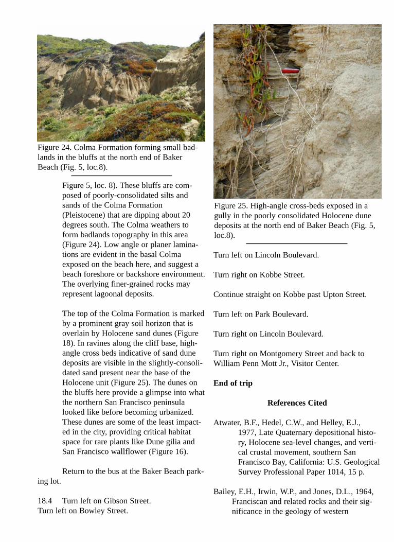
Figure 5, loc. 8). These bluffs are com-posed of poorly-consolidated silts andsands of the Colma Formation(Pleistocene) that are dipping about 20degrees south. The Colma weathers toform badlands topography in this area(Figure 24). Low angle or planer lamina-tions are evident in the basal Colmaexposed on the beach here, and suggest abeach foreshore or backshore environment.The overlying finer-grained rocks mayrepresent lagoonal deposits.
The top of the Colma Formation is markedby a prominent gray soil horizon that isoverlain by Holocene sand dunes (Figure18). In ravines along the cliff base, high-angle cross beds indicative of sand dunedeposits are visible in the slightly-consoli-dated sand present near the base of theHolocene unit (Figure 25). The dunes onthe bluffs here provide a glimpse into whatthe northern San Francisco peninsulalooked like before becoming urbanized.These dunes are some of the least impact-ed in the city, providing critical habitatspace for rare plants like Dune gilia andSan Francisco wallflower (Figure 16).
Return to the bus at the Baker Beach park-ing lot.
18.4 Turn left on Gibson Street.Turn left on Bowley Street.
Turn left on Lincoln Boulevard.
Turn right on Kobbe Street.
Continue straight on Kobbe past Upton Street.
Turn left on Park Boulevard.
Turn right on Lincoln Boulevard.
Turn right on Montgomery Street and back toWilliam Penn Mott Jr., Visitor Center.
End of trip
References Cited
Atwater, B.F., Hedel, C.W., and Helley, E.J.,1977, Late Quaternary depositional histo-ry, Holocene sea-level changes, and verti-cal crustal movement, southern SanFrancisco Bay, California: U.S. GeologicalSurvey Professional Paper 1014, 15 p.
Bailey, E.H., Irwin, W.P., and Jones, D.L., 1964,Franciscan and related rocks and their sig-nificance in the geology of western
Figure 24. Colma Formation forming small bad-lands in the bluffs at the north end of BakerBeach (Fig. 5, loc.8).
Figure 25. High-angle cross-beds exposed in agully in the poorly consolidated Holocene dunedeposits at the north end of Baker Beach (Fig. 5,loc.8).

California: California Division of Mine andGeology Bulletin 183, 177 p.
Blake, M.C., Jr., 1984, Franciscan Geology ofNorthern California: Pacific Section SEPM,v. 43, 254 p.
Blake, M.C., Howell, D.G., and Jayko, A.S.,1984, Tectonostratigraphic terranes of theSan Francisco Bay region, in Blake, M.C.,Jr. (ed.), Franciscan Geology of NorthernCalifornia: Pacific Section SEPM, v. 43, p.5-22.
Bouma, A.H., 1962, Sedimentology of SomeFlysch Deposits — A Graphic Approach toFacies Interpretation: Elsevier Scientific,167 p.
Coleman, R.G., 1989, Serpentinites, inWahrhaftig, C. and Sloan, D. (eds.),Geology of the San Francisco and Vicinity,28th International Geological Congress FieldTrip Guidebook T105, p.10-11.
Cox, A., and Engebretsen, D.C., 1985, Change inmotion of Pacific Plate at 5 Ma: Nature, v.313, p. 472-474.
Decker, K., 1991, Rhythmic bedding in siliceoussediments – An overview, in Einsele, G.,Ricken, W., and Seilacher, A. (eds.), Cyclesand Events in Stratigraphy: Springer-Verlag,Berlin, Heidelberg, p. 464-479.
Fischer, A.G., 1991, Orbital cyclicity in Mesozoicstrata, in Einsele, G., Ricken, W., andSeilacher, A. (eds.), Cycles and Events inStratigraphy: Springer-Verlag, Berlin,Heidelberg, p. 48-62.
Elder, W.P., 1998, Mesozoic molluscan fossilsfrom the Golden Gate National RecreationArea and their significance to terrane recon-structions for the Franciscan Complex, SanFrancisco Bay area, California, in Santucci,V.L., and Lindsay, M. (eds.), National ParkService Paleontological Research: NationalPark service Technical Report
NPS/NRGRD/GRDTR-98/01, p. 90-94.
Hertlein, L. G., 1956, Cretaceous ammonite ofFranciscan group, Marin County, California:American Association of PetroleumGeologists Bulletin, v. 40, p. 1985-1988.
Hill, M. R., 1970, Barrier Beach: CaliforniaGeology, v. 23, no. 12, p. 231-233.
Karl, S.M., 1984, Sedimentologic, diagenetic, andgeochemical analysis of Upper Mesozoicribbon cherts from the FranciscanAssemblage at the Marin Headlands,California, , in Blake, M.C., Jr. (ed.),Franciscan Geology of Northern California:Pacific Section SEPM, v. 43, p. 71-88.
Kruckenberg, A.R., 1984, California serpentines— Flora, vegetation, geology, soils, andmanagement problems: University ofCalifornia Publications in Botany, v. 78, 180p.
Moore, J.G., 1975, Mechanism of formation ofpillow lava: American Scientist, v. 63, p.269-277.
Moore, J.G., and Charlton, D.W., 1984, Ultrathinlava layers exposed near San Luis ObispoBay, California: Geology, v. 12, p. 542-545.
Murchey, Benita, 1984, Biostratigraphy andlithostratigraphy of chert in the FranciscanComplex, Marin headlands, California, inBlake, M.C., Jr. (ed.), Franciscan Geologyof Northern California: Pacific SectionSEPM, v. 43, p. 51-70.
Murchey, Benita, and Jones, D.L., 1984, Age andsignificance of chert in the FranciscanComplex in the San Francisco Bay region, ,in Blake, M.C., Jr. (ed.), Franciscan Geologyof Northern California: Pacific SectionSEPM, v. 43, p. 23-30.
Page, B.M., 1989, Coast Range uplifts and struc-tural valleys, in Wahrhaftig, C. and Sloan,D. (eds.) Geology of the San Francisco and
Vicinity, 28th International GeologicalCongress Field Trip Guidebook T105, p. 30-32.
Page, B.M., and Wahrhaftig, Clyde, 1989, SanAndreas fault and other features of the trans-form regime, in Wahrhaftig, C. and Sloan,D. (eds.) Geology of the San Francisco andVicinity, 28th International GeologicalCongress Field Trip Guidebook T105, p. 22-27.
Schlocker, Julius, 1974, Geology of the SanFrancisco North Quadrangle, California:U.S. Geological Survey Professional Paper782, 109 p.
Schlocker, Julius, Bonilla, M. G., and Imlay, R.W., 1954, Ammonite indicates Cretaceousage for part of Franciscan group in SanFrancisco Bay area, California: AmericanAssociation of Petroleum GeologistsBulletin, v. 38 p. 2372-2381.
Shervais, J.V., 1989, Geochemistry of igneousrocks from Marin Headlands, in Wahrhaftig,C. and Sloan, D. (eds.) Geology of the SanFrancisco and Vicinity, 28th InternationalGeological Congress Field Trip GuidebookT105, p. 40-41.
Sloan, Doris, 1989, San Francisco Bay, inWahrhaftig, C. and Sloan, D. (eds.) Geologyof the San Francisco and Vicinity, 28thInternational Geological Congress Field TripGuidebook T105, p. 46-47.
Tada, R., 1991, Compaction and cementation insiliceous rocks and their possible effect onbedding enhancement, in Einsele, G.,Ricken, W., and Seilacher, A. (eds.), Cyclesand Events in Stratigraphy: Springer-Verlag,Berlin, Heidelberg, p. 480-491.
VanderHoof, V. L., 1951, History of geologicinvestigation in the bay region, in GeologicGuidebook of the San Francisco BayCounties: California Division of MinesBulletin 154, p. 109-116.
Wahrhaftig, Clyde, 1984a, Structure of the MarinHeadlands block, California: A progressreport, in Blake, M.C., Jr. (ed.), FranciscanGeology of Northern California: PacificSection SEPM, v. 43, p. 31-50.
Wahrhaftig, Clyde, 1984b, A Streetcar toSubduction and Other Plate tectonic Trips byPublic Transportation in San Francisco,revised edition: Washington, D.C., AmericanGeophysical Union, 72 p.
Wahrhaftig, Clyde and Sloan, Doris, 1989,Geology of the San Francisco and Vicinity,28th International Geological Congress FieldTrip Guidebook T105, 69 p.
Wahrhaftig, Clyde, and Murchey, Benita, 1987,Marin Headlands, California: 100-million-year record of sea floor transport and accre-tion: Geological Society of AmericaCentennial Field Guide, Volume 1 –Cordilleran Section, p. 263-268.
Wahrhaftig, Clyde, and Wakabayashi, John, 1989,Tectonostratigraphic terranes, in Wahrhaftig,C. and Sloan, D. (eds.), Geology of the SanFrancisco and Vicinity, 28th InternationalGeological Congress Field Trip GuidebookT105, p. 6-8.
Wakabayashi, John, 1999, The FranciscanComplex, San Francisco Bay Area – A record ofsubduction complex processes, in Wagoner, D.L.and Graham, S.A. (eds.), Geologic Field Trips inNorthern California: California Division of Minesand Geology Special Publication 119, p. 1-21.
Wakeley, J.R., 1970, The unique beach sand atRodeo cove: California Geology, v. 23, no.12, p. 238-241.