geomedia desktop
TRANSCRIPT
Introducing GeoMedia 2013:Introducing GeoMedia 2013:A modern, dynamic, powerful and flexible GIS management platform for the extraction ofl ti bl i f ticlear, actionable information
Sebastian OmondiGIS TechnicianOakar Services Ltd
SMARTERDECISIONS
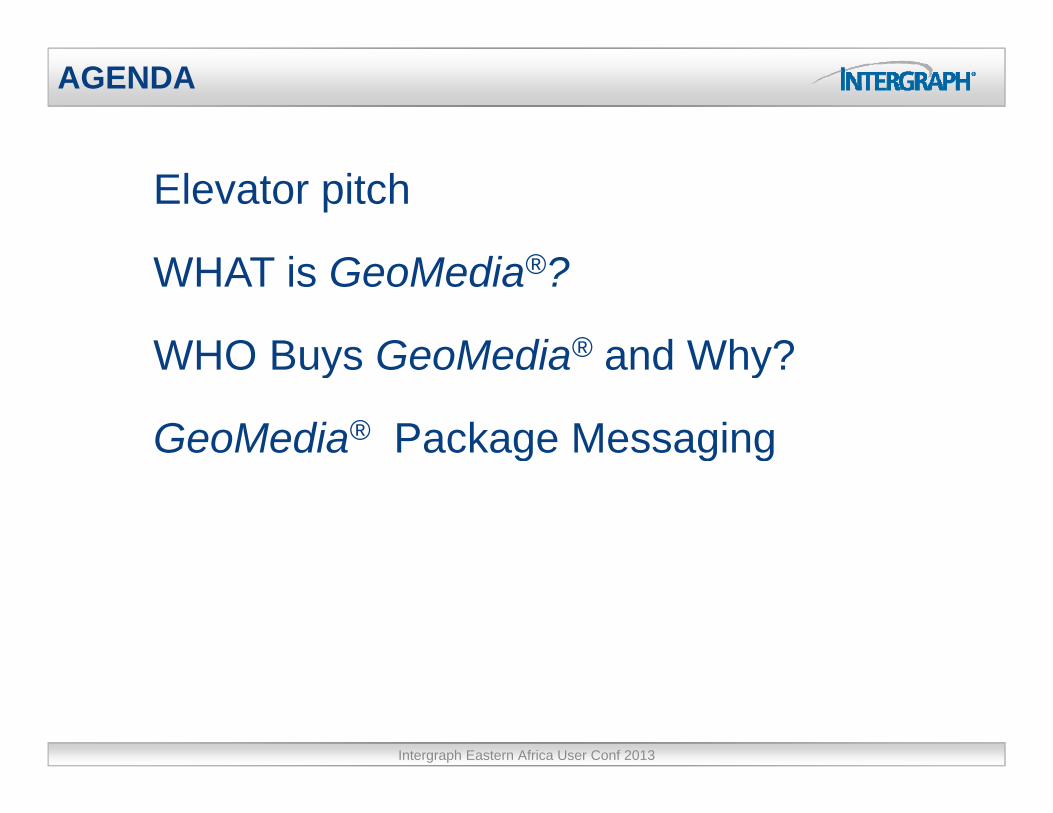
AGENDA
Elevator pitch
WHAT is GeoMedia®?
WHO Buys GeoMedia® and Why?WHO Buys GeoMedia® and Why?
GeoMedia® Package Messagingg g g
Intergraph Eastern Africa User Conf 2013
G M di i t ibl ti l i t
Elevator Pitch
GeoMedia is an open, extensible geospatial environment
for natively accessing, displaying, editing
and analyzing data from various sources and formats.
It’s based on industry standards such as OGC
and ISO, and uses de-facto standards such as Oracle,
Microsoft SQL Server and PostGIS.”
Intergraph Eastern Africa User Conf 2013
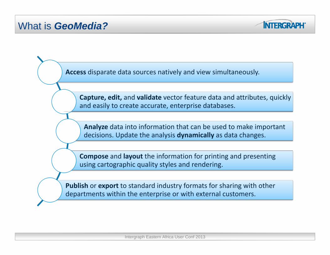
What is GeoMedia?
Access disparate data sources natively and view simultaneously.
Capture, edit, and validate vector feature data and attributes, quickly and easily to create accurate, enterprise databases.
Analyze data into information that can be used to make important decisions. Update the analysis dynamically as data changes.
Compose and layout the information for printing and presenting using cartographic quality styles and rendering.
Publish or export to standard industry formats for sharing with other departments within the enterprise or with external customers.
Intergraph Eastern Africa User Conf 2013
WHO Buys GeoMedia and WHY?WHO Buys GeoMedia and WHY?
SMARTERDECISIONS

Municipal Planning and Management
Local/regional/central governments are under increased pressure to:
• Deliver services at lowers costs due to budget constraints and fewer resources
• Improve public services to maximize the use of tax revenue
• Ensure the infrastructure is safefor the public
Intergraph Eastern Africa User Conf 2013

Transportation Infrastructure Management
Transportation agencies need
to ensure traffic safety and
protect road infrastructure
while minimizing disruption to
the flow of vehicles, goods, and
passengers.
Intergraph Eastern Africa User Conf 2013
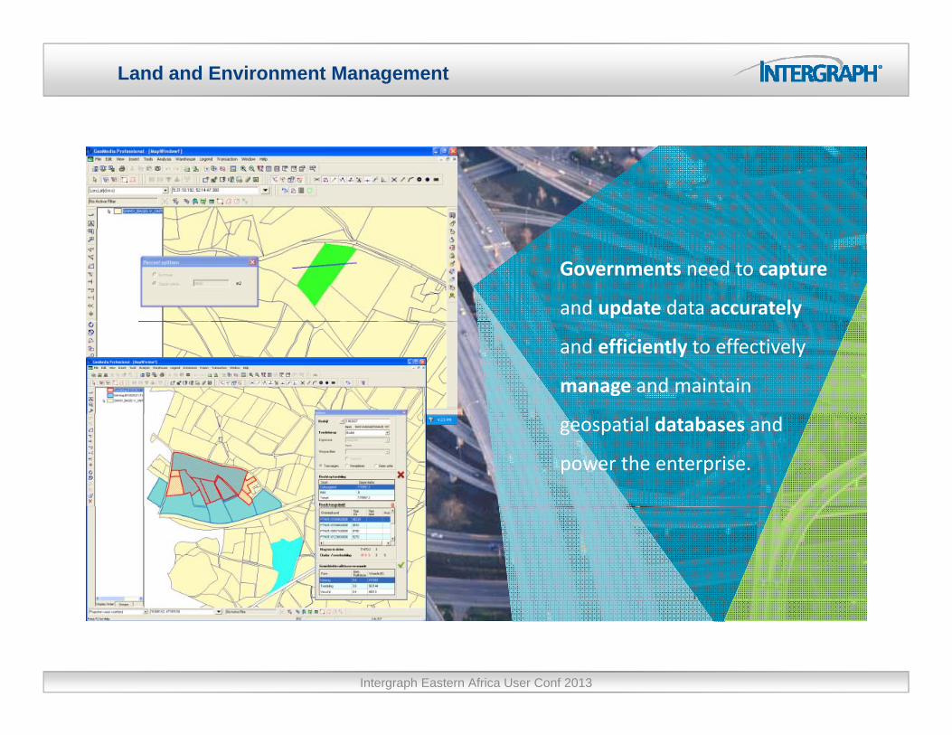
Land and Environment Management
Governments need to capture
and update data accurately
and efficiently to effectively
manage and maintain
geospatial databases and
power the enterprise.
Intergraph Eastern Africa User Conf 2013

Mapping and Cartographic Production
Governments and DOTs need toGovernments and DOTs need to
regularly produce both digital and
hardcopy mapping products. They
are pressed to reduce overall
timeframes for production while
maintaining a high degree of
cartographic quality and meeting
mapping specifications.mapping specifications.
Intergraph Eastern Africa User Conf 2013
The GeoMedia messageThe GeoMedia message
SMARTERDECISIONS
GeoMedia is an open extensible geospatial environment for:
The GeoMedia Desktop Messaging
GeoMedia is an open extensible geospatial environment for:
Natively accessing and displaying in a single view, various data sources and formats
Capturing and editing geospatial data using an extensive set of placement and editing commands
Visualizing features and queries to exact style or symbologyVisualizing features and queries to exact style or symbologyspecifications
Analyzing data and performing complex, ad-hoc, what-if analysis
Performing map composition and printing
Exporting data to the most common or standard formats
GeoMedia uses industry and de-facto standards such as ISO OGC and OracleGeoMedia uses industry and de-facto standards such as ISO, OGC, and Oracle, allowing customers to easily integrate GeoMedia into their enterprise.
GeoMedia is a platform for add-on products and third-party products. As a platform, it facilitates end-user software customization and configuration.
Intergraph Eastern Africa User Conf 2013
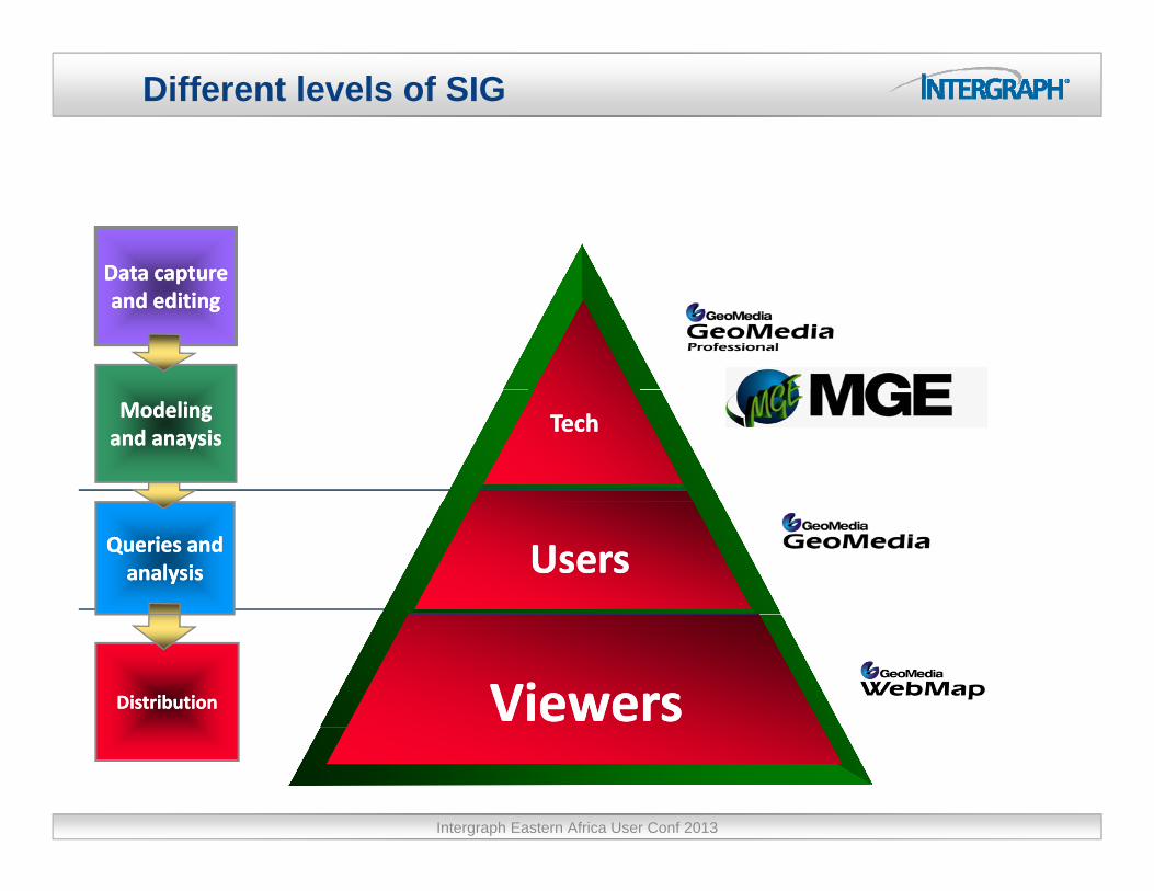
Different levels of SIG
Data captureData captureData capture Data capture and editingand editing
Modeling Modeling and and anaysisanaysis
TechTech
Queries and Queries and analysisanalysis UsersUsers
DistributionDistribution ViewersViewers
Intergraph Eastern Africa User Conf 2013

The GeoMedia Vision
Enabling you, our customers, to:
CreateCreate
Manage
Exploit
information, in a geospatial context so you will have:context, so you will have:
Clarity for running your daily operations
Abilit t k iti l b iAbility to make critical business decisions.
Intergraph Eastern Africa User Conf 2013

The GeoMedia functionalityThe GeoMedia functionality
SMARTERDECISIONS

Data sources
MapsMaps Text dataText dataMGSMMGSM
MGE MGE ARC/INFOARC/INFO
GeoMediaGeoMediaProfessionalProfessional
PhotosPhotosEventsEvents
ProfessionalProfessional InformsInforms
VideosVideos
FRAMMEFRAMME
DocumentsDocuments
Printed mapsPrinted mapsFilmsFilms
FRAMME FRAMME
Intergraph Eastern Africa User Conf 2013

Data Access & Ingest. Data servers
Oracle DataS
Oracle DataS CADCAD dgnServerServer CAD
Data ServerCAD
Data Serverdxf
AutoCAD2010
.8
.7
GeoMedia
SQL ServerData ServerSQL ServerData Server ArcView
Data ServerArcView
Data Server
GMLGML
shp.5
G/TechData Server
G/TechData Server
I/CADI/CAD
WFSData Server
WFSData Server
GMLData Server
GMLData Server
ddc
gml
.6
I/CADData Server
I/CADData Server
TerraShareData ServerTerraShareData Server
WMSData Server
WMSData Server
map
WFS, WMS & WCS
T Sh KMLKMLWCS
Data ServerWCS
Data ServerWebsitesTerraShare
Client
KMLData Server
KMLData Server .4
Intergraph Eastern Africa User Conf 2013

Data Maintenance & Access – Metadata Catalogs
How well do you really know your data?How well do you really know your data?
Intergraph Eastern Africa User Conf 2013
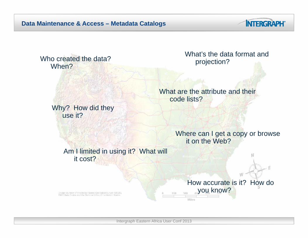
Data Maintenance & Access – Metadata Catalogs
Who created the data? When?
What’s the data format and projection?
What are the attribute and their code lists?
Why? How did they use it?
Where can I get a copy or browseWhere can I get a copy or browse it on the Web?
Am I limited in using it? What will it cost?
How accurate is it? How do you know?
Intergraph Eastern Africa User Conf 2013

Data Maintenance & Access – Metadata Catalogs
Where can I find new feature or image data within my
Enterprise, so I can improve my maps and analysis?
Intergraph Eastern Africa User Conf 2013

Data Maintenance & Access – Metadata Catalogs
Use GeoMedia Catalog to connect to Geospatial Metadata in your Enterprise!g p y p
Intergraph Eastern Africa User Conf 2013
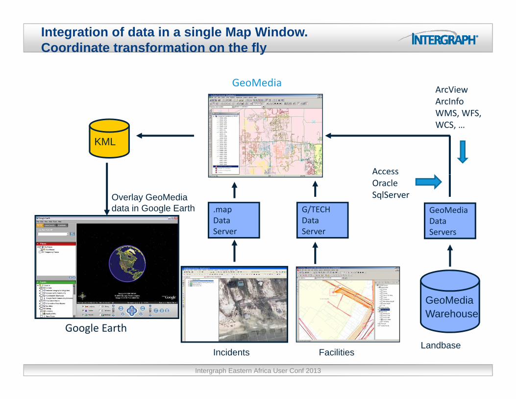
Integration of data in a single Map Window.Coordinate transformation on the fly
GeoMediaArcViewArcInfoWMS, WFS, WCS
KML
Access
WCS, …
GeoMediaData
G/TECHData
.mapData
Overlay GeoMediadata in Google Earth
OracleSqlServer
ServersServerServer
GeoMediaWarehouse
G l E th
The image cannot be displayed. Your computer may not have enough memory to open the image, or the image may have been corrupted. Restart your computer, and then open the file again. If the red x still appears, you may have to delete the image and then insert it again.
Google Earth
FacilitiesIncidentsLandbase
Intergraph Eastern Africa User Conf 2013

Data Access & Ingest
GeoMedia
BING MapsI/F
BING MapsI/F
User Authenticated
GeoMediaData ServerGeoMedia
Data Server
I/FI/F
BING or Pictometry GeoMedia Map WindowGeoMediaWarehouse
PictometryI/F
PictometryI/F .8
Synchronized
WFS, WMS or WCS Web
Server
Intergraph Eastern Africa User Conf 2013
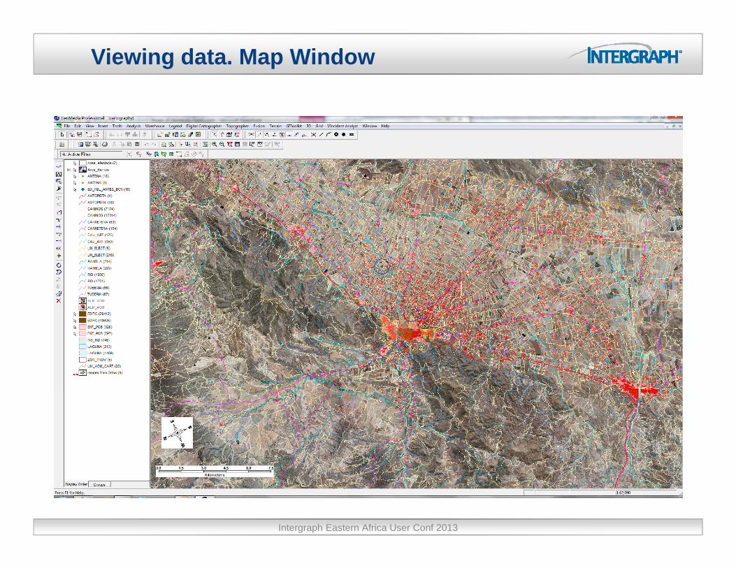
Viewing data. Map Window
Intergraph Eastern Africa User Conf 2013

Viewing data. Data Window
Intergraph Eastern Africa User Conf 2013

Printing data. Map composition
Intergraph Eastern Africa User Conf 2013
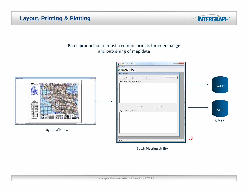
Layout, Printing & Plotting
Batch production of most common formats for interchangeand publishing of map data
GeoTIFF
GeoPDF
Layout Window
CMYK
Batch Plotting Utility
.8
Intergraph Eastern Africa User Conf 2013

Data Maintenance & Access – Construction Aids
Want different ways of constructing feature geometry using related, existing features and minimizing the use of button clicks?
Now in these commands:
Insert Feature
Continue
Redigitize
Edit GeometryConstruction Aids are available to make it easier to collect and
No need to exit command –available as right click Edit Geometry
Split Feature
Snaps
to make it easier to collect and edit geometry
g
Intergraph Eastern Africa User Conf 2013

Placement & Editing
Quickly remove unnecessary geometry (vertices) from features
.5
AfterBefore
Intergraph Eastern Africa User Conf 2013
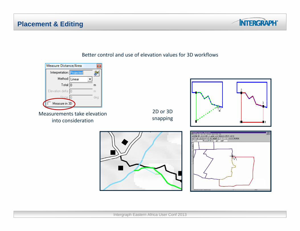
Placement & Editing
Better control and use of elevation values for 3D workflows
Measurements take elevation into consideration
2D or 3D snapping
Intergraph Eastern Africa User Conf 2013
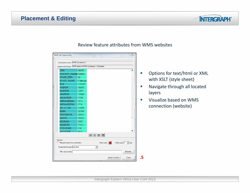
Placement & Editing
Review feature attributes from WMS websites
Options for text/html or XML with XSLT (style sheet)
Navigate through all located layers
Visualize based on WMS connection (website)
5.5
Intergraph Eastern Africa User Conf 2013

Data Capturing - Exporting
Intergraph Eastern Africa User Conf 2013

Queries and analysis
Queries
• Attribute ‐ Spatial ‐ BothAttribute Spatial Both
Analysis
• Analytical combination
• Buffer zoneBuffer zone
• Aggregation
• Spatial intersection
• Spatial differenceSpatial difference
• Functional attributes
• Address geocoding enhancements improve paccuracy, add flexibility in address matching
Intergraph Eastern Africa User Conf 2013

Query & Analysis. Functional attributes
New expression for substituting text supports subsets and wildcards
Analyze WMS data with respect to timeto time
Intergraph Eastern Africa User Conf 2013

Raster & Image Processing
GeoTIFF export from the Layout Window
BIGTIFF
Georeferenced MrSID
JPEG 2000 with GeoTIFF tagstags
Remove need for world files and .csf
Intergraph Eastern Africa User Conf 2013
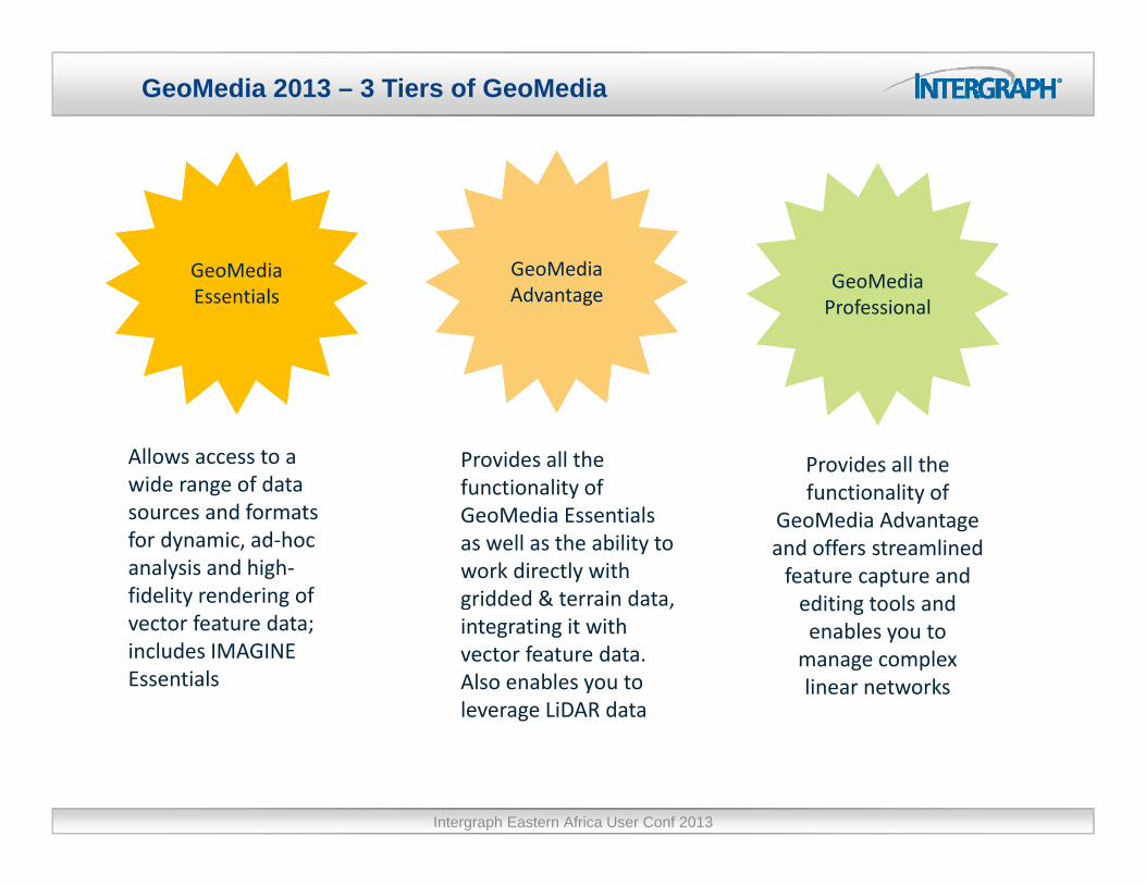
GeoMedia 2013 – 3 Tiers of GeoMedia
GeoMedia GeoMedia G M diGeoMediaEssentials
GeoMediaAdvantage
GeoMediaProfessional
Allows access to a wide range of data
Provides all the functionality of
Provides all the functionality of
sources and formats for dynamic, ad‐hoc analysis and high‐fidelity rendering of
yGeoMedia Essentials as well as the ability to work directly with gridded & terrain data,
functionality of GeoMedia Advantage and offers streamlined feature capture and editing tools and
vector feature data; includes IMAGINE Essentials
integrating it with vector feature data. Also enables you to leverage LiDAR data
editing tools and enables you to manage complex linear networks
Intergraph Eastern Africa User Conf 2013

GeoMedia 2013
Intergraph Eastern Africa User Conf 2013

GeoMedia 2013 - 3 Tiers of GeoMedia
Essentials – Query and analysis of geospatial data plus IMAGINE Essentials for i l i i d hsimple image preparation and enhancement
Advantage – Essentials plus GeoMedia Grid and Terrain providing a full GIS analytical package
Professional – Advantage plus all feature collection, editing and qualitycontrol functionality.
Intergraph Eastern Africa User Conf 2013
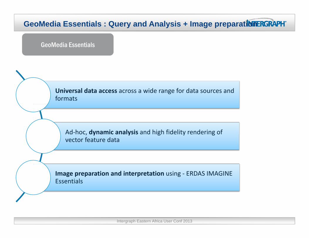
GeoMedia Essentials : Query and Analysis + Image preparation
GeoMedia EssentialsGeoMedia EssentialsGeoMedia EssentialsGeoMedia Essentials
Universal data access across a wide range for data sources and formats
Ad‐hoc, dynamic analysis and high fidelity rendering ofAd hoc, dynamic analysis and high fidelity rendering of vector feature data
Image preparation and interpretation using ‐ ERDAS IMAGINE Essentials
Intergraph Eastern Africa User Conf 2013

Analysis
Intergraph Eastern Africa User Conf 2013
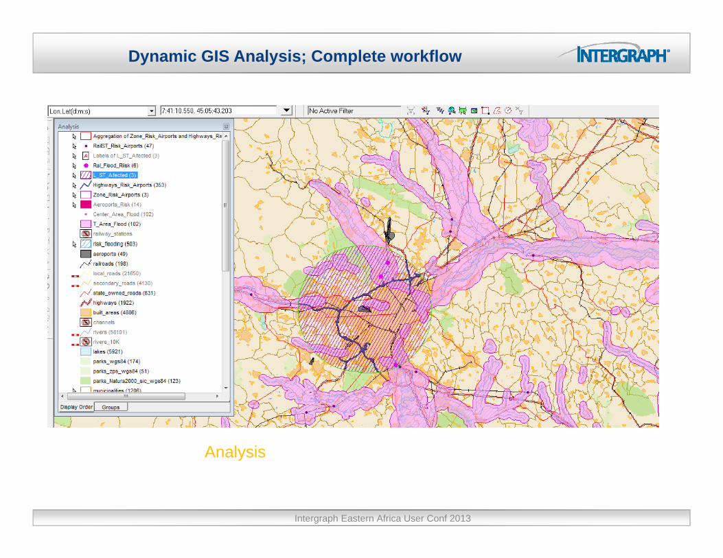
Dynamic GIS Analysis; Complete workflow
AnalysisAnalysis
Intergraph Eastern Africa User Conf 2013

Incorporate Non-Graphic Information using Linear Reference Systems (LRS)
Intergraph Eastern Africa User Conf 2013

GeoMedia 2013 – New, Modern User Experience
Logically grouped commands in ribbon control
Ribbon can auto‐hide to maximize screen space
Add and remove commands onto your own custom
tab
Intergraph Eastern Africa User Conf 2013

GeoMedia 2013 – Fast Display
Client‐side cache improves displayimproves display
times
Display times improved from minutes tominutes to seconds
Cache is kept up to date as editing is performed
Intergraph Eastern Africa User Conf 2013
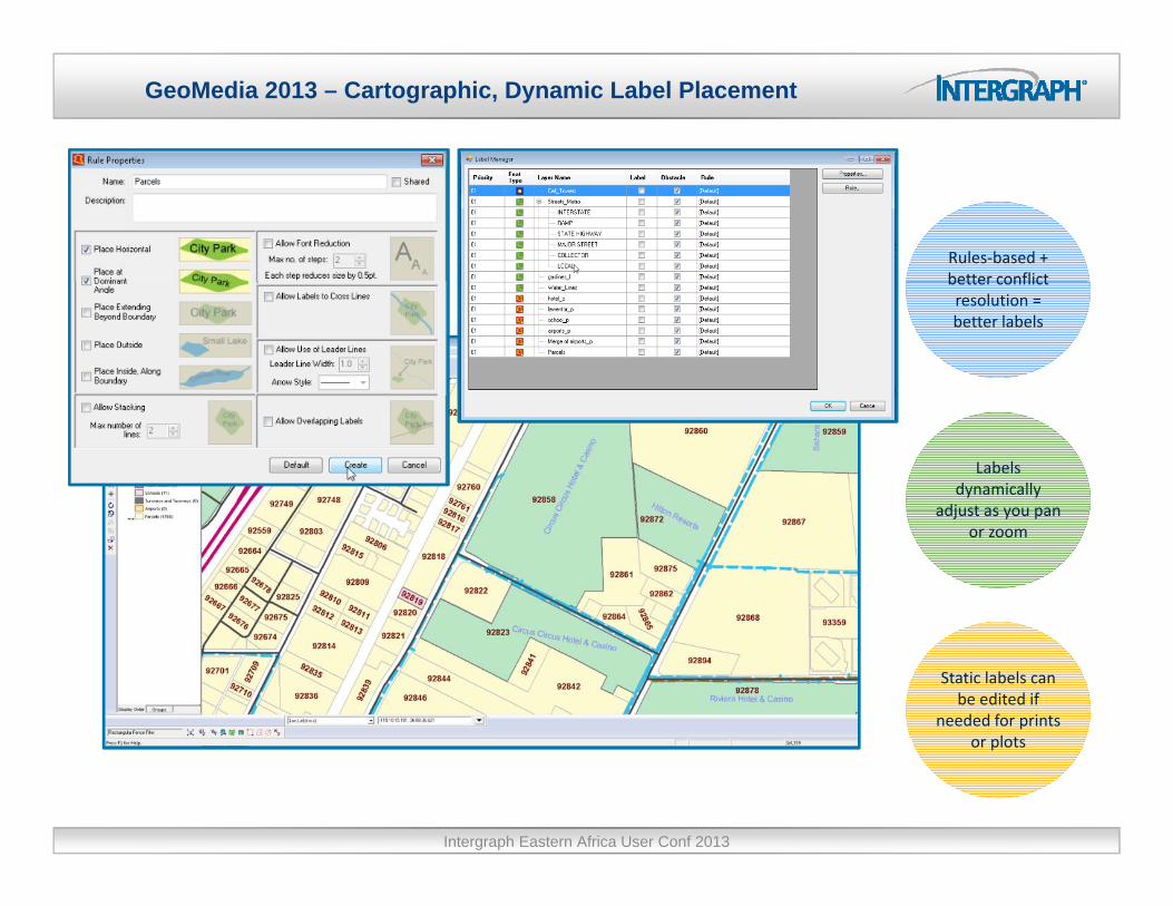
GeoMedia 2013 – Cartographic, Dynamic Label Placement
Rules‐based + better conflictbetter conflict resolution = better labels
Labels dynamically
adjust as you panadjust as you pan or zoom
Static labels can be edited if
needed for prints or plotsor plots
Intergraph Eastern Africa User Conf 2013
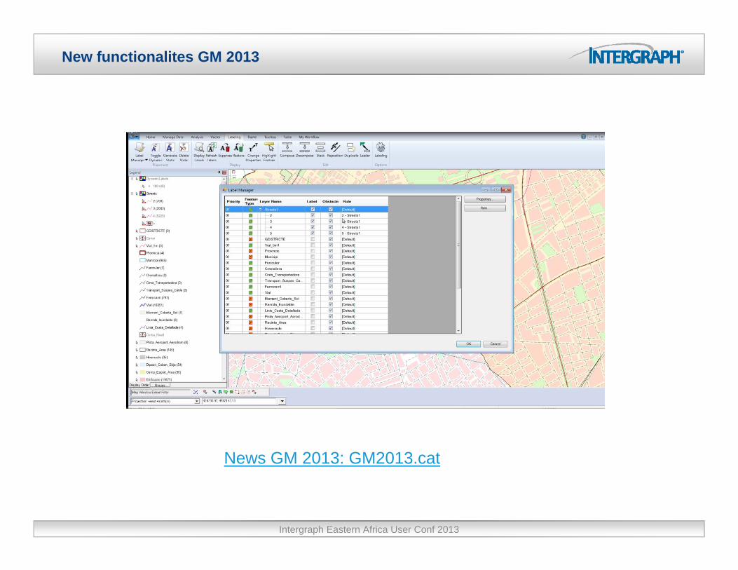
New functionalites GM 2013
News GM 2013: GM2013.cat
Intergraph Eastern Africa User Conf 2013

Spatial Modeler. Vector operators
Queries_Spatial_Modeler.avi
Intergraph Eastern Africa User Conf 2013
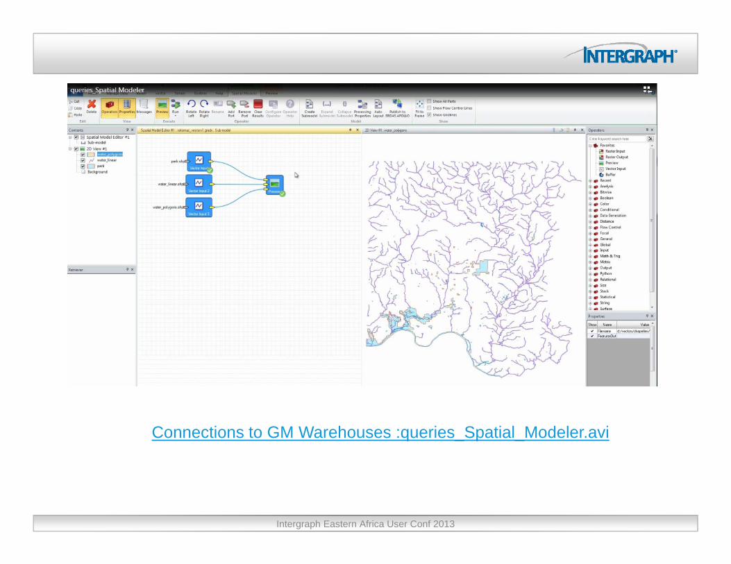
Connections to GM Warehouses :queries_Spatial_Modeler.avi
Intergraph Eastern Africa User Conf 2013

GeoMedia 2013 – Access Imagery via ERDAS APOLLO
Quick and easy delivery ofdelivery of
“unstructured” image data
Query based on spatial extent, keywords timekeywords, time
and date
Gridded, detailed or thumbnail view of query
res ltsConection from GM to Apollo catalog: apolloCatalogo avi resultsConection from GM to Apollo catalog: apolloCatalogo.avi
Intergraph Eastern Africa User Conf 2013

ERDAS IMAGINE Image & Terrain
Intergraph Eastern Africa User Conf 2013
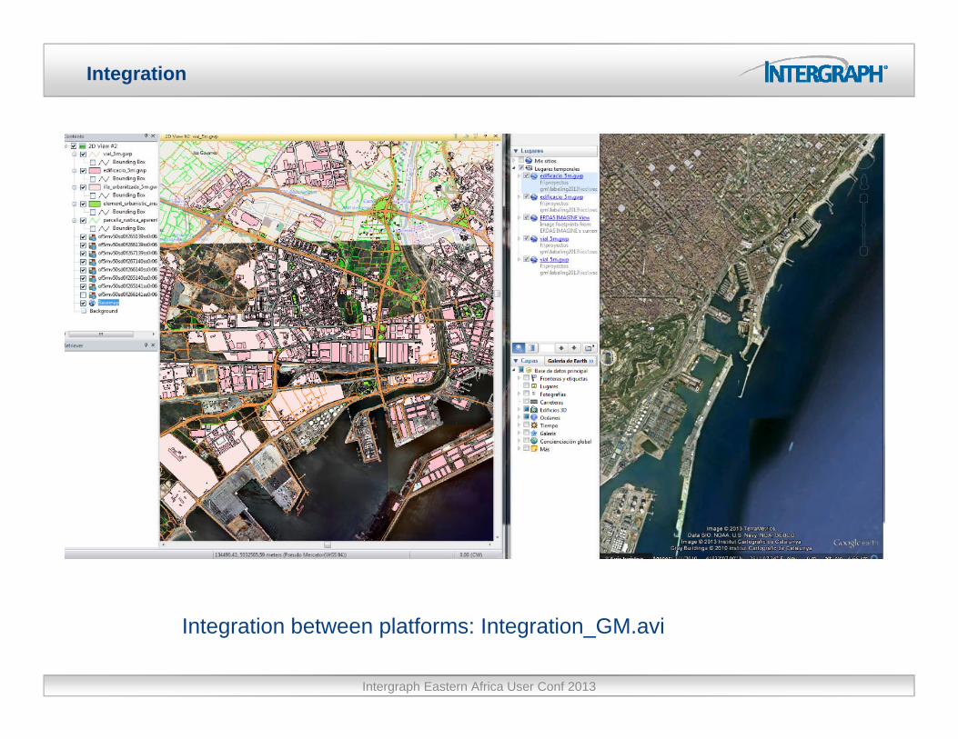
Integration
Intergraph Eastern Africa User Conf 2013
Integration between platforms: Integration_GM.avi

Tools integration
Intergraph Eastern Africa User Conf 2013
Interactive connections:Imagine_GM.avi
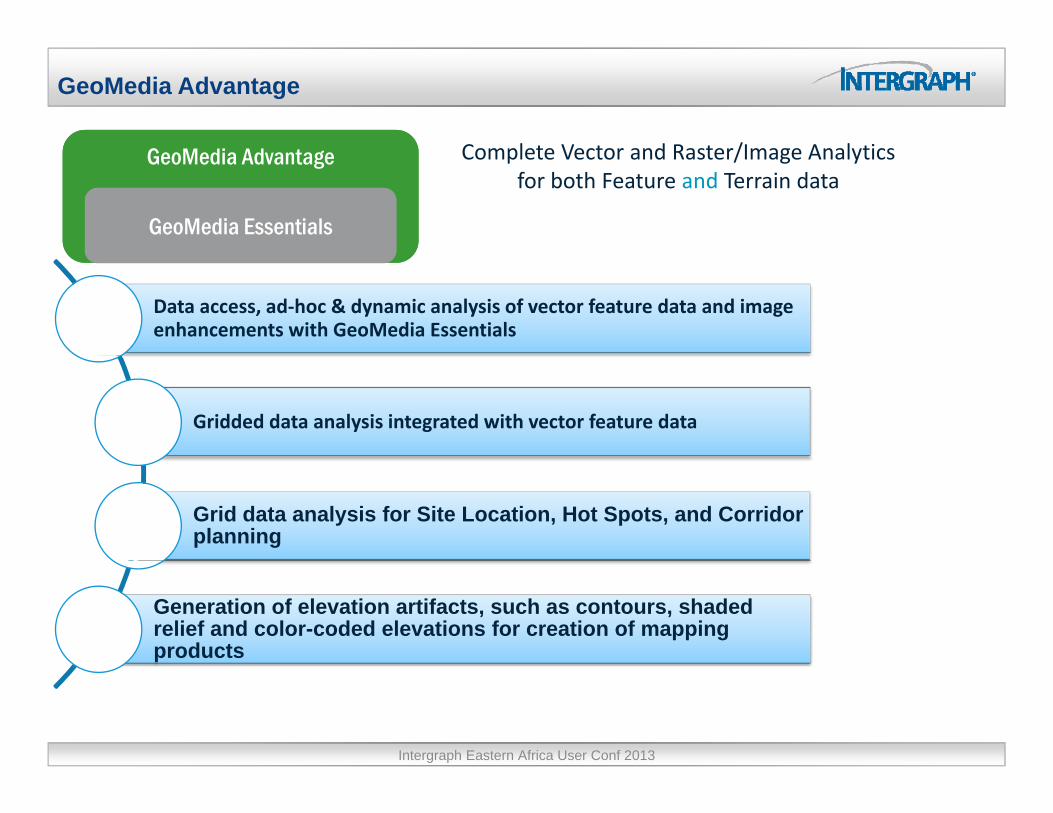
GeoMedia Advantage
Complete Vector and Raster/Image AnalyticsG M di Ad tG M di Ad t Complete Vector and Raster/Image Analyticsfor both Feature and Terrain data
GeoMedia AdvantageGeoMedia Advantage
GeoMedia EssentialsGeoMedia Essentials
Data access, ad‐hoc & dynamic analysis of vector feature data and image enhancements with GeoMedia Essentials
Gridded data analysis integrated with vector feature data
Grid data analysis for Site Location, Hot Spots, and Corridor planning
Generation of elevation artifacts, such as contours, shaded relief and color-coded elevations for creation of mapping products
Intergraph Eastern Africa User Conf 2013
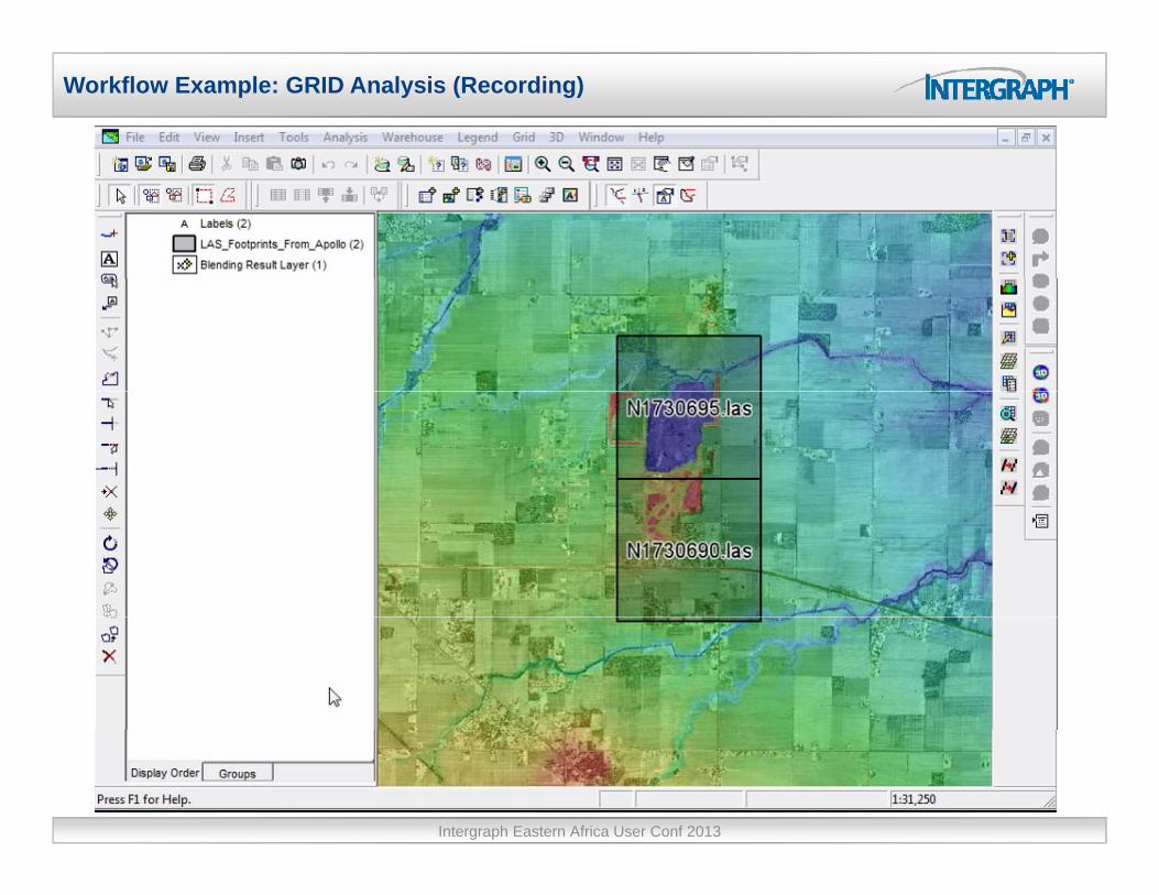
Workflow Example: GRID Analysis (Recording)
Intergraph Eastern Africa User Conf 2013
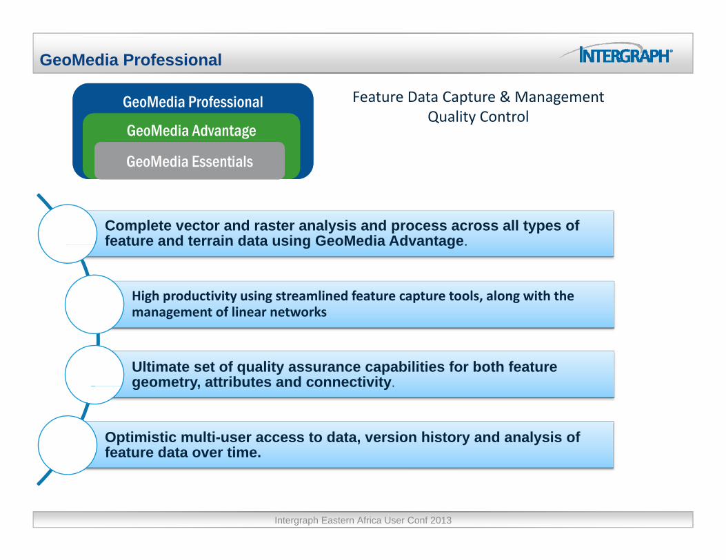
GeoMedia Professional
Feature Data Capture & ManagementGeoMedia ProfessionalGeoMedia Professional p gQuality Control
GeoMedia ProfessionalGeoMedia Professional
GeoMedia AdvantageGeoMedia Advantage
GeoMedia EssentialsGeoMedia Essentials
Complete vector and raster analysis and process across all types of feature and terrain data using GeoMedia Advantage.feature and terrain data using GeoMedia Advantage.
High productivity using streamlined feature capture tools, along with the management of linear networksmanagement of linear networks
Ultimate set of quality assurance capabilities for both feature geometry, attributes and connectivity.geometry, attributes and connectivity.
Optimistic multi-user access to data, version history and analysis of feature data over time.feature data over time.
Intergraph Eastern Africa User Conf 2013

Easily Incorporate Data from IMAGINE; Advanced Editing
Intergraph Eastern Africa User Conf 2013
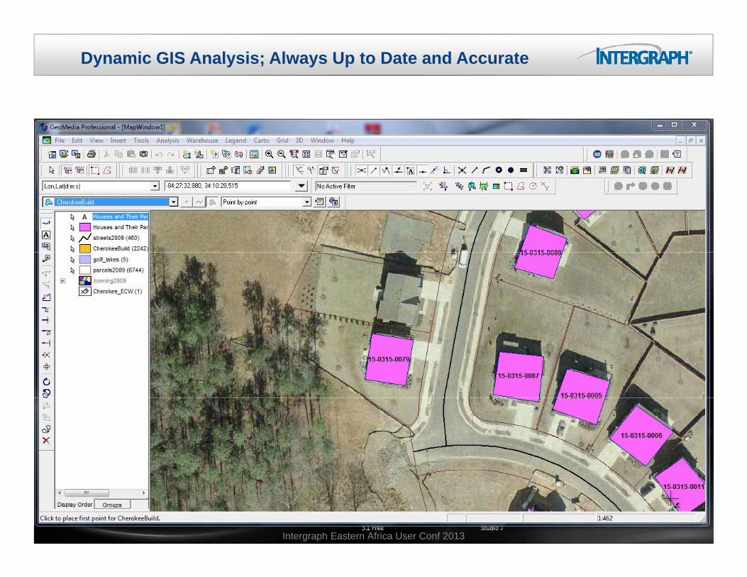
Dynamic GIS Analysis; Always Up to Date and Accurate
Intergraph Eastern Africa User Conf 2013

Label Along Existing Featureg g
Intergraph Eastern Africa User Conf 2013

GeoMedia packaging
GeoMedia Mapping Manager
GeoMedia Mapping Manager
GeoMediaTransportation
Manager
GeoMediaTransportation
Manager
GeoMedia ProfessionalGeoMedia Professional
GeoMedia AdvantageGeoMedia AdvantageGeoMedia Database GeoMedia Database GeoMedia AdvantageGeoMedia Advantage
GeoMedia EssentialsGeoMedia Essentials
GeoMedia Database Manager
GeoMedia Database Manager
GeoMedia 3DGeoMedia 3D
Intergraph Eastern Africa User Conf 2013
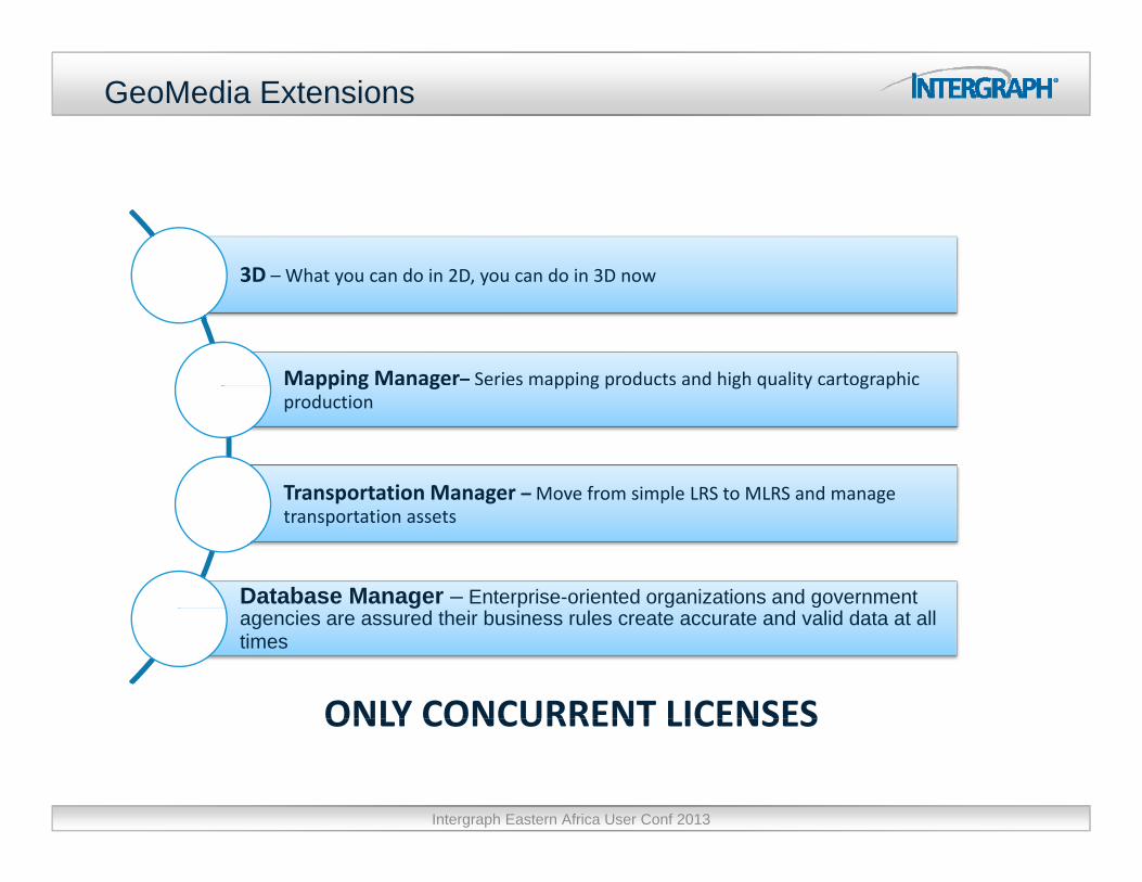
GeoMedia Extensions
3D What you can do in 2D you can do in 3D now3D – What you can do in 2D, you can do in 3D now
Mapping Manager– Series mapping products and high quality cartographic pp g g pp g p g q y g pproduction
Transportation Manager –Move from simple LRS to MLRS and manageTransportation Manager Move from simple LRS to MLRS and manage transportation assets
Database Manager – Enterprise-oriented organizations and government gagencies are assured their business rules create accurate and valid data at all times
ONLY CONCURRENT LICENSESONLY CONCURRENT LICENSES
Intergraph Eastern Africa User Conf 2013

Modelización 3D
Escenario GM 3D
Intergraph Eastern Africa User Conf 2013

GeoMedia 3D
Intergraph Eastern Africa User Conf 2013

GeoMedia 3D
Intergraph Eastern Africa User Conf 2013
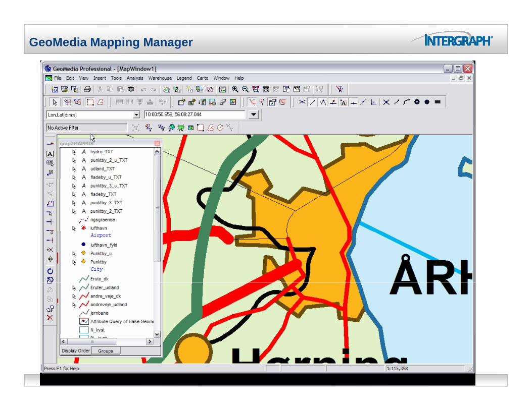
GeoMedia Mapping Manager
Intergraph Eastern Africa User Conf 2013
QuestionsQuestionsThank you
Begoña Verdejo HerrerasSenior Presales Engineer.
Security, Government & Infrastructure
Tel.+34 91 [email protected]
SMARTERDECISIONS

Intergraph Eastern Africa User Conf 2013