geomorph coopersa toads finaldraft · 5 the cane toad life cycle consists of breeding, eggs,...
TRANSCRIPT

Government of South Australia
South Australian Arid Lands NaturalResources Management Board
October 2013South Australian Arid Lands Natural Resources Management Board
Cane toads and South Australian Arid Lands geomorphology
Gresley A. Wakelin-King
CANE TOADS AND SOUTH AUSTRALIAN ARID LANDS GEOMORPHOLOGY
Gresley A. Wakelin-King1
October 2013
Report to the South Australian Arid Lands Natural Resources Management Board
1Wakelin Associates, PO Box 271, Clifton Hill, Melbourne, Australia;
www.wakelinassociates.com.au

2
DISCLAIMER The South Australian Arid Lands Natural Resources Management Board, and its employees do not
warrant or make any representation regarding the use, or results of use of the information contained
herein as to its correctness, accuracy, reliability, currency or otherwise. The South Australian Arid Lands
Natural Resources Management Board and its employees expressly disclaim all liability or responsibility
to any person using the information or advice.
This report may be cited as:
Wakelin-King, G.A., 2013. Cane Toads and South Australian Arid Lands Geomorphology. Report by
Wakelin Associates to the South Australian Arid Lands Natural Resources Management Board, Port
Augusta.
Cover image:
L) Cane Toad [Credit: David Peacock]
R) Cooper Creek’s North West Branch is a complex of discontinuous distributary channels, set amongst
dunefields, alluvial flats, lakes and swamps. [Image prepared by Gresley Wakelin-King, Wakelin
Associates, using part of the Strzelecki Rural 2001 orthophoto. Orthophoto custodian: South Australian
Department of Environment, Water and National Resources, Adelaide.]
© South Australian Arid Lands Natural Resources Management Board 2013
This work is copyright. Apart from any use permitted under the Copyright Act 1968 (Commonwealth), no
part may be reproduced by any process without prior written permission obtained from the South
Australian Arid Lands Natural Resources Management Board. Requests and enquiries concerning
reproduction and rights should be directed to the Regional Manager, South Australian Arid Lands
Natural Resources Management Board, Railway Station Building, PO Box 2227, Port Augusta, SA, 5700

3
Table of Contents
Introduction 6
Summary and Recommendations 6
Recommendations 10
Appendix 1: Technical Background 12
Cane Toads 12
Potential toad habitat in Cooper Creek 16
Cane toad control 20
References 22
4
Introduction During 2011-2012, the South Australian Arid Lands Natural Resources Management
Board (SAALNRM) undertook the (Caring for our Country) Cooper Creek project
“Managing the high ecological value aquatic ecosystems (HEVAE) of the Cooper
Creek catchment (SA section)”. As part of the sub-project “Geomorphological
assessment and analysis of the Cooper Creek catchment (SA section)”, this report
considers the feral cane toad and how the study area’s landforms contribute to or
detract from its possible invasion paths and habitats. The area covered by this report
encompasses the Cooper's catchment within South Australia, and also considers an
area extending northeast ~400 km upstream from the South Australia-Queensland
border (where the geomorphology is of direct relevance to the aims of this project).
This report on cane toads is a partner to the report “Geomorphological assessment
and analysis of the Cooper Creek catchment (SA section)” (Part 1: “Geomorphology
Report and Recommendations” and “Part 2: Technical Report”) (Wakelin-King 2013).
Summary and Recommendations Cane toads are an invasive species whose range in Australia is rapidly increasing,
and whose effect on ecosystems derives from toad toxicity to predators (Shine 2010).
In the high-value aquatic ecosystems of refuge waterholes, animals (including fish,
Greenlees & Shine 2011) are at risk from eating the highly toxic eggs and less toxic
tadpoles. Though in other locations larger fish and turtles are protected from the toxic
eggs because of the eggs’ emplacement in shallow water, the Cooper’s succession
of flood peaks risks washing eggs into deeper waters where larger animals can eat
them. The rich riparian zones of refuge waterholes are equally important to land
animals, who will be at risk from predation on the terrestrial adult toads. Established
toad colonies along the Cooper are clearly undesirable.
It is less obvious that unsuccessful toad colonies may also be highly detrimental to
Cooper Creek ecology. Toad colonies may not be able to establish if their breeding
ponds – on the floodplain – are only temporary. The toads might lay eggs, but
perhaps the shallow water will not persist long enough to grow adult toads able to
migrate. However, that brief time of floodplain inundation is an important time in fish
ecology. Fish escaping from their refuge waterholes seek the floodplains as an
opportunity to feed, grow, and find new breeding grounds. Thus, toad eggs may pose
a new threat at a time which is critical for the genetic diversity of arid-zone fish.

5
The cane toad life cycle consists of breeding, eggs, tadpoles, metamorphs, and
adults. Breeding must take place at the water’s edge, and the eggs and tadpoles are
aquatic. The metamorphs and adults are terrestrial, and risk drowning in deep water.
The adults are extremely tough, can travel long distances (up to 1.3 km in a night),
and can tolerate some desiccation, but they must rehydrate every couple of days.
The metamorphs are highly vulnerable to desiccation, and must stay close to water.
For the cane toad invasion front to establish in a new location, the key habitat
requirements are water for rehydration while travelling, daytime shelters, and suitable
breeding habitat.
Across Australia, the cane toad invasion front has recently increased in rapidity, and
by virtue of both behavioural change and genetic alteration the toads are increasingly
able to occupy challenging habitat. Fortunately, cane toad dispersal takes place by
movement of the terrestrial adults, not by swimming of the aquatic stages, so the
recent wet years may not have promoted toad expansion beyond what has been
observed in drier years. They have reached southwestern Queensland, and there is
no reason why they can't penetrate further down Cooper Creek. Published models of
cane toad expansion, which conclude that South Australia is too dry for cane toad
populations to establish, are based on a poor understanding of Channel Country
rivers and are certainly incorrect.
Whether water is available for rehydration of toads travelling down moisture corridors
of the Cooper depends on 1) how far apart water bodies are, and 2) the hydrology at
the time in question (how long since the last flood; the degree of floodplain
inundation). In order to prioritise likely cane toad invasion pathways and identify
“weakest link” reaches for targeted toad control, it is desirable to document for
various flow conditions the locations of permanent, semipermanent, and temporary
waters, and what their upstream-downstream distance relationships are.
There is no shortage of landforms and landscape elements that could serve as toad
shelters during the day (Fig. 1). This is not a limiting factor to cane toad invasion and
establishment. As well as natural features, toads are good at exploiting human
habitat, and community engagement will be an important factor of their control.

6
Fig. 1 Potential daytime shelter for toads: left, bank tree roots near Tilcha Waterhole; right, a distributary
channel offtake with vegetation.
There are many potential breeding sites available to invading cane toads (Fig. 2,
Table 1). Cooper Creek's hydrology is not dependent on locally-derived rainfall; much
of its water comes from the semi-tropical north. Current hydrological investigation
indicates that (Justin Costelloe, pers. comm. 2012):
under the current evaporation rate and inflow frequency, many waterholes and lakes persist for years to decades (Table 1);
the longest period of probable no flow in the Cooper since 1939 was 21 months, and waterbodies >4 m in depth should retain water for longer than that period;
Coongie Lake has probably only dried twice, briefly, in the last 40 years
upstream from Coongie Lake (Northwest Branch) and Embarka Waterhole (Main Branch) there are a string of essentially permanent waterholes all the way up to the upper catchment;
downstream of these locations, the waterbodies would periodically dry out and could remain dry for several years.
In fact, the waterholes of the Coongie Lakes area already support Central Australia’s
richest frog community (Reid & Puckridge 1990). There are also many artificial water
sources from human-built infrastructure: short-term but numerous over a wide area
(e.g. borrow pits) and long-term to permanent (evaporation ponds, dams). Higher
salinity or lower pH may be detrimental to toads, and a more detailed picture of the
Cooper Creek’s and the lakes’ water chemistry would assist in prioritising control
areas.
7
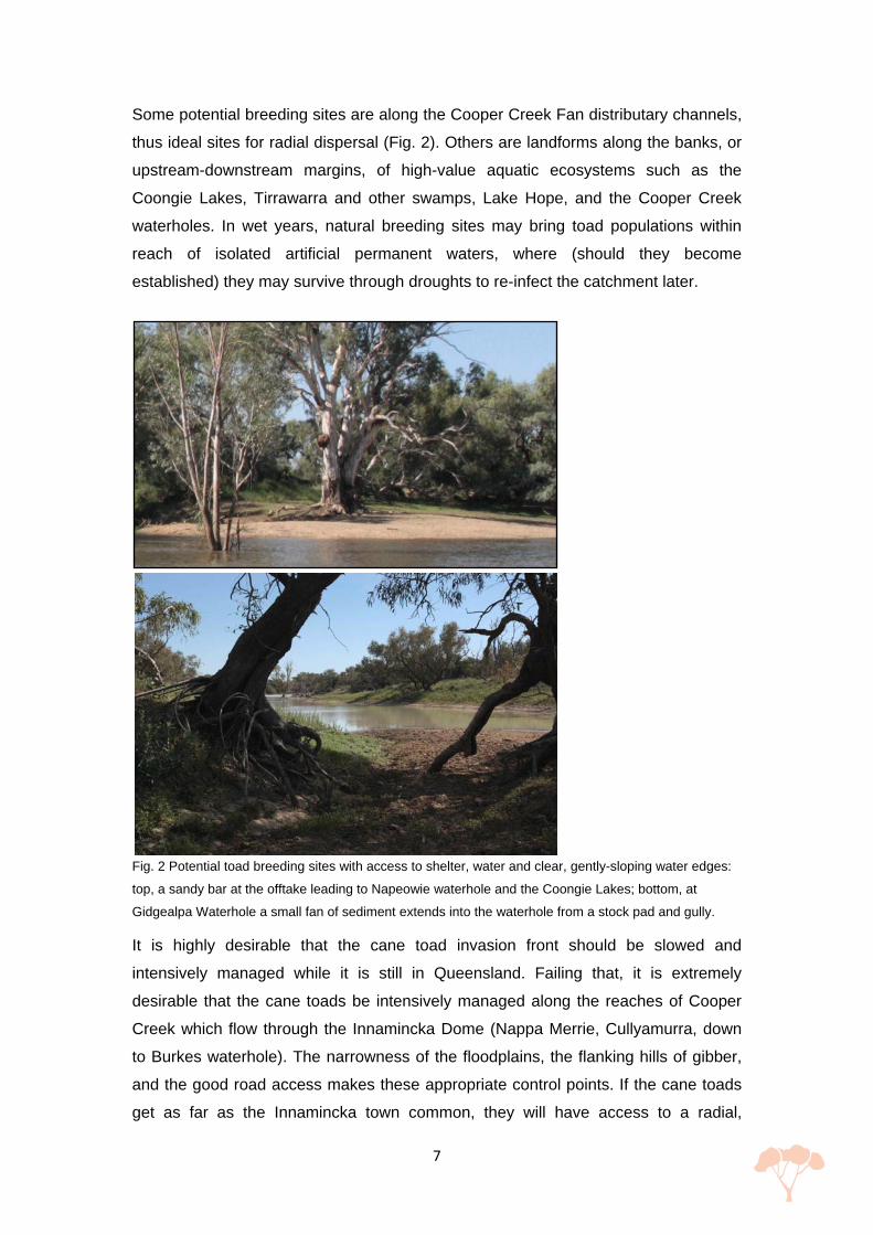
Some potential breeding sites are along the Cooper Creek Fan distributary channels,
thus ideal sites for radial dispersal (Fig. 2). Others are landforms along the banks, or
upstream-downstream margins, of high-value aquatic ecosystems such as the
Coongie Lakes, Tirrawarra and other swamps, Lake Hope, and the Cooper Creek
waterholes. In wet years, natural breeding sites may bring toad populations within
reach of isolated artificial permanent waters, where (should they become
established) they may survive through droughts to re-infect the catchment later.
Fig. 2 Potential toad breeding sites with access to shelter, water and clear, gently-sloping water edges:
top, a sandy bar at the offtake leading to Napeowie waterhole and the Coongie Lakes; bottom, at
Gidgealpa Waterhole a small fan of sediment extends into the waterhole from a stock pad and gully.
It is highly desirable that the cane toad invasion front should be slowed and
intensively managed while it is still in Queensland. Failing that, it is extremely
desirable that the cane toads be intensively managed along the reaches of Cooper
Creek which flow through the Innamincka Dome (Nappa Merrie, Cullyamurra, down
to Burkes waterhole). The narrowness of the floodplains, the flanking hills of gibber,
and the good road access makes these appropriate control points. If the cane toads
get as far as the Innamincka town common, they will have access to a radial,

8
distributary river network, from which they will have access to the rest of Cooper
Creek and the Strzelecki Creek.
Locations Maximum Cease-To-Flow Depth
Water persistence without inflow (y)
Inflow frequency /a
Murken waterhole (Qld) # 5.14 2.2 <1
Yalungah waterhole (Qld) # 4.31 1.9 <1
Meringhina waterhole (Qld) # 4.50 2.0 <1
Nappa Merri waterhole 11.71 5.1 <1
Cullyamurra waterhole 25.0 10.9 <1
Minkie waterhole 6.35 2.8 <1
Coongie Lake 1.80 0.75 <1
Tirrawarra swamp* <1.8? 0.75? <1
Embarka waterhole 3.80 1.7 1
Gidgealpa waterhole 4.07 1.8 3.6-5.7
Lake Hope 6.80 3.0 3.6
Lake Kilamperpunna No information <2? 5.7
Yaningurie waterhole 3.00 1.3 8.0-13.3
Table T1 Persistence of water in the Cooper Ck landscape: approximate values for selected water-retaining landforms, indicating (per annum) how long water persists after a fill event, and how frequently new flows may come in (Justin Costelloe, pers. comm. 2012). Note that these recurrence intervals are indicative only, and cannot fully express the variability of the flow patterns in this catchment; see Costelloe, 2012. # Data from: Hamilton et al. 2005. The mean annual open water evaporation loss at Moomba is 2.285 m y-1.
Recommendations 1. Development of a strategy for management of the cane toad invasion.
Management of the cane toad invasion front may be more successful in the
Queensland reach of Cooper Creek (Windorah to Nappa Merrie) than it has been in
the Top End, since the invasion front would only be as wide as the inundated parts of
the Cooper floodplain. In combination with maps of dispersion pathways, it may be
possible to develop a strategy of slowing or holding the toad front in “weakest link”
reaches, by dry-year toad busting and tadpole trapping along key landforms in the
primary dispersion paths. If the toads reach the Innamincka Dome, the pinch points
near Nappa Merrie and Cullyamurra waterholes are tightly constrained between
waterless uplands, and may represent the best places for toad call monitoring, and
the best opportunities for defensive toad busting and tadpole trapping.
2. Better understanding of the cane toads of southwestern Queensland.
Working with the Queensland Desert Channels Group and toad ecologists, establish
9
the location of the Jundah toad front since the 2010-2012 wet years, and verify the
habitat preferences, dehydration and temperature tolerances, and capacity for
overland travel of this population of toads. Particular attention should be given to
investigating toad exploitation of landform elements that they have not previously
encountered: gilgai macropores (“crabholes”), GAB springs, waterhole splay
channels, etc.
3. Database and map of prioritised toad dispersion pathways in
southwestern Queensland: finding the “weakest link”. To manage toad
populations before they get to high-value waterholes in South Australia, it would be
necessary to work with Queensland agencies to identify pathways along the river
network where waterholes or other water sources are close enough together that
cane toads may travel downriver. From this information, key locations (“weakest link”
reaches) for monitoring, fencing, and toad busting may be selected, such that
denying toads this water will break the upstream-downstream dispersion path. A
database constructed from geomorphic, hydrologic, landholder and historical data
would be used to map spatial relationships of accessible water locations at various
flood heights. Water locations would be assessed with respect to toad-travel
distances; ideally this work would be done in partnership with toad physiologists and
modellers. A GIS dataset of waterhole locations and attributes is already available
(Silcock 2009).
4. Stakeholder engagement with cane toad control in South Australia and
Queensland. Cane toads are known to be particularly successful in exploiting human
habitats. If cane toads successfully invade the Strzelecki plain, local control of
artificial permanent water and shelter will be very important, especially during dry-
year targeted toad control. Measures will include fencing evaporation ponds,
monitoring and toad busting dams and borrow pits, and restricting access to daytime
refuge sites. The cooperation of the hydrocarbon exploration and extraction industry
is particularly important, because their infrastructure is widespread and closely-
spaced, and also because their type of work makes toad stowaways a strong
possibility.
5. Document water chemistry in the Cooper and its lakes. The present
information merely covers total solutes expressed as conductivity. A survey of solute
type and concentration, pH and other relevant information would assist in prioritising
vulnerable areas, and would improve understanding of the nature and causes of
down-gradient salinity change.

10
6. Landform/habitat mapping of key locations in South Australia and
Queensland. Targeted pest control will be aided by detailed landform mapping to
identify likely toad habitat. This will be of assistance in managing toad populations
over large waterholes with limited budgets and staff. It is likely to be a very important
precursor to toad busting and tadpole trapping in locations of complex
geomorphology, such as distributary offtake valleys or complex shallow reaches.
Appendix 1: Technical Background
Cane Toads
The daily cycle of the adult cane toad revolves around hydration and sheltering from
desiccation. Toads are nocturnal: they spend daylight hours out of sight, sheltering in
small confined spaces (burrows, deep soil cracks in black-soil country, small gaps
between rocks) or beneath the cover of vegetation (Tingley & Shine 2011). Their
refuge spaces can include apparently quite unfavourable situations (such as hiding
beneath a sheet of corrugated iron exposed to the sun, Steve Wilson, ex-Desert
Channels Queensland, pers. comm., 2012). At dusk toads emerge from their
shelters, to rehydrate by immersing their ventral surfaces in shallow water (they don't
drink), and to move around either locally (established populations) or away from the
day's refuge site (advancing invasion front). During the night's movement, the toads
feed (primarily on insects, but they will eat anything; CSIRO 2003). Males may
congregate around a suitable breeding location (open ground around the edge of
shallow water) and call to attract females; females may be more widely dispersed
away from the breeding locations. Cane toads are known to be very successful at
exploiting human environments for shelter and rehydration, utilising sub-floor spaces,
pet-food bowls, and drip patches beneath air-conditioners or leaking taps (Matt
Greenlees, University of Sydney, pers. comm., 2012).
Cane toad life cycles are dependant upon the availability of warmth and water, but it
is important to note that
the adults are largely terrestrial and their original native range includes seasonal dryness,
in Australia, they are increasingly occupying zones where conditions are more extreme than those of their native range (Urban et al. 2007),

11
their adaptive behaviours have allowed them to be increasingly well-adapted to seasonal drought in the Top End (Brown et al. 2011),
they have demonstrated plasticity in cold tolerance, allowing them to invade colder regions of south eastern Australia (Kolbe et al. 2010),
and (most importantly) cane toads at the invasion front also display genetic adaptability, displaying longer legs (fast forward progress, therefore better access to new breeding sites) (Philips et al. 2007), enhanced dispersal abilities (Alford et al. 2009) and greater ability to deal with arid conditions (more rapid water uptake, better ability to travel long distances while dehydrated) (Tingley et al. 2012).
Thus, the cane toad life cycle described below should be recognised as being
derived from places where the cane toad currently exists. It does not represent
factors that can be assumed to limit the toads' ability to expand into South Australia's
Arid Lands.
The cane toad life cycle moves through the following stages: amplexus (breeding),
eggs, tadpoles, metamorphs, adult toads. Unless otherwise referenced, this
information is pers. comm., Matt Greenlees, University of Sydney, 2012.
1. Amplexus (breeding). Toads will seek out a suitable breeding site: a body of still or slow-flowing water, with a shallow edge and little surrounding vegetation. They will preferentially seek such a site (Semeniuk et al 2007), even if it requires they move away from the main river (David Peacock, PIRSA, pers. comm., 2012; and see Doody et al. 2006). Males congregate around the edge, calling for females; females range more widely away from the breeding site, and will come in if attracted by a male's call. Amplexus is when the male clasps the female's back, in order to externally deposit sperm on the eggs as the eggs are laid. Ideally this takes place in shallow water with a gently-shelving incline. Amplexus can take place in a vegetated riparian zone, but it is less common. It can take place in deeper water, or on a more steeply inclined bank, however the female toad risks being drowned. Toad breeding sites are characteristically described as shallow ponds, farm dams, roadside culverts, and shallow streams and billabongs (Philips et al. 2007, Kearney et al. 2008, KBT1 2012). Parameters: the likelihood of a breeding event is restricted by minimum temperature; maximum temperature has not been known to be a controlling factor.
2. Eggs are laid in shallow water: the female toad's feet are touching the ground when she lays the eggs, and her head is above water. The eggs are laid in long neat strings of non-toxic gelatinous material containing of pairs of very toxic tiny black eggs. It is not known whether the egg strands are sticky; it is possible that eggs might float free, or become entwined around vegetation, and they have been known to become stranded by falling water levels. It is

12
unlikely that the eggs would remain viable if they are out of the water for very long. Two possibilities arise if egg strings become detached from the breeding site and transported elsewhere (for example, by a flood pulse). Firstly, the eggs may be transported to a new hatching location. This will be detrimental if toad control is being targeted around known breeding sites. Secondly, the eggs may end up in deeper water, bringing their toxin within the depth range of larger waterhole fish or turtles. To date, there have been no reports of egg detachment, however the locations of previous studies have not been on rivers whose water levels fluctuate on a day-to-day basis (whereas the Lake Eyre Basin channel country rivers are characterised by complex hydrology and multiple flood peaks). Parameters: the time needed between laying and hatching is generally 2-3 days, however that will be temperature dependent, and there are indications that toads are adapting to cooler temperatures. The effect of water salinity and acidity on the eggs is currently being investigated.
3. Tadpoles will move between shallow and deep water but are most often seen as swarms in shallow water (close to the ideal metamorph habitat). The time needed between hatching and metamorphosis can be as little as 17 days or as much as 6 months (CSIRO 2003). The amount of time they spend in this stage affects their adult fitness. If they spend a short time as tadpoles, they turn into little metamorphs and are thus less resistant to desiccation, and their fitness as adults is also compromised. Parameters: this stage is affected by temperature, feeding, competition, and the presence of predators (fear pheromones lead to faster development, therefore the tadpoles are smaller when they turn into metamorphs). Tadpoles will live amongst emergent vegetation. Tadpole swarms caught up in flowing water might result in dispersal, however if they're not at the water's edge during metamorphosis the metamorphs will drown. The effect of water salinity and acidity on tadpoles is not known.
4. The metamorphs are tiny black toadlets. They are very prone to dehydration, and cluster near muddy gently-sloping banks near the edge of shallow water. They don't need to enter water to rehydrate, just press their ventral surface against damp ground. They don't swim well and might drown in flowing water, however they are unlikely to enter the water. If conditions are dry their daily shelter spot needs to be within a couple of metres of their rehydration spot, however if conditions are moist they can go ~100 m from water. Unlike native frogs, they are not known to shelter in toilet cisterns or bowls. There is no information on the limiting parameters of water temperature, air/ground temperature, water salinity or acidity, or length of time to develop into adult toads.
5. Adult toads need to rehydrate regularly, but the length of time between hydration depends on activity levels, temperature, and humidity. Toads that are travelling (invasion front) will be in trouble if they can't rehydrate every 2-3 days, whereas toads that are sheltering have apparently been observed to last two weeks without water (KTB1 2012). Toad activity in the Top End is at a maximum in warm, wet, and windy nights (Philips et al. 2007). Because moisture and warmth is so strongly correlated in the Top End, where most of

13
the research has taken place, there is little information on other temperature/moisture conditions, however since toads are ectotherms, minimum temperature is likely to be a limiting parameter. Toads move an average of 50-150 m per night (with much higher maximum distances) so presumably the daytime shelter doesn't have to be very close to the rehydration site.
While there is clear evidence that toads hitchhike in vehicles (Shine Research Group
2011a, NT News Photo Gallery 2012), the most recent invasion wave across the Top
End has taken place by the efforts of the toads themselves. Toads expanding into
new territory along the invasion front move from one water source to another, so
tending to travel long moisture corridors such as river primary flow paths. However
they travel overland (not by swimming, although they can swim across strongly
flowing streams), and can cross very dry or otherwise difficult country (rocky, densely
vegetated, very steep, dry black-soil plains) (Schwartzkopf & Alford 2005, Matt
Greenlees pers. comm. 2012). Daily travel distances are typically <100-200m, but
vary widely according to conditions. Individuals have been tracked at single-night or
average-per-night distances of >200m, 750 m, 1 km, 1.3 km, (Schwartzkopf &
Alford 2005, Phillips et al. 2007), and toads have been observed colonising artificial
watering points up to 9.5 km from permanent natural waters (Florance et al. 2011) .
Invasion front toads tend to travel in approximately straight lines, away from their
natal pond. They also tend to keep a distance from other pioneer toads, so the end
result is a lot of toads all moving in the same direction. Toads prefer to travel along
clear pathways such as roads or cleared fencelines, and travel more slowly in
heavier vegetation. The toad populations along the invasion front are different in
age/size, gender balance, behaviour, and genetics from those resident in established
toad territory, and the complex travel patterns appear to differ along gender lines
(Schwartzkopf & Alford 2005, KTB2 2012).
A number of studies have attempted to predict the eventual distribution of cane toads
in Australia by matching their known habitat preferences and limiting parameters
(temperature, water requirements, etc.) to Australian climate zones (Kearney et al.
2008, Urban et al. 2007, Urban et al. 2008, Florance et al. 2011). While well-
grounded in literature on toad ecology, they are inadequate as predictive tools
because their understanding of arid-zone landforms and hydrology is minimal. A
study on the role of artificial watering points as potential toad habitat (Florance et al.
2011) develops a valuable methodology, but its results are compromised because its

14
data sources (intended to show the locations of permanent natural waters) are
incomplete and were not ground-truthed. Sophisticated computer models matching
toad physiology to bioclimatic conditions (Urban et al. 2007, Kearney et al. 2008)
assesses presence/absence of suitable breeding sites in such an extremely simplistic
fashion that the Cooper Creek's permanent waterholes and Ramsar listed wetlands
are presumed to not exist. Indicative lengths of water retention of some Cooper
Creek waterbodies are shown in Table T1. These publications will disadvantage the
South Australian Arid Lands Natural Resources Management Board in competitive
funding applications on a national level, since they falsely indicate the SAAL NRM
area is unlikely to be in danger of cane toad invasion. While the authors would rightly
point out that a model is not supposed to be taken seriously beyond the limitations of
its input data, the fact remains that readers unfamiliar with or unaware of those
limitations will take the conclusions at face value. This has already occurred (see
Peacock 2007, Urban et al. 2008, Phillips et al. 2008, Beckman & Shine 2009, Shine
2010, Florance et al. 2011).
Potential toad habitat in Cooper Creek
The key cane toad habitat requirements are water for rehydration while travelling,
daytime shelters, and suitable breeding habitat.
For toads to successfully expand downstream Cooper Creek, rehydration of water
sites must be no more than 3-4 days toad-travel apart. Any patch of shallow water (or
a shallow edge to deep water) is sufficient for adult toad rehydration, so the
availability of sites for toad rehydration depends on the current hydrology of the
system. In wet years, water is continuous along the channel network and in places
the floodplains are inundated, so there would seem to be few limits to toad expansion
down and across the Cooper's fluvial network. In light of the recent flow events
(2010-2012) (Costelloe 2012), it would be desirable to actively seek information on
the current location of the toad invasion front in Queensland.
In more dry years, the likely expansion corridors would be more limited. It would be
possible to map and prioritise likely dispersion pathways for high-flow and low-flow
hydrological scenarios by firstly defining the locations of suitable water, by combining
geomorphic information (flow paths, permanent and semipermanent waterholes, primary and secondary channels, and using gilgai morphology to map more and less-inundated floodplains)
hydrological data (Costelloe 2012), and

15
landholder data, and historical records of waterhole permanence (Silcock 2009).
Water locations would then have buffer zones established around them to indicate
toad-travel distances. Where buffer zones intersect, a potential pathway of toad
travel would exist. A simplistic model based on the travel distances measured from
the Top End would make that distance 3.9-5.2 km. (More sophisticated models
incorporating temperature and other biophysical conditions are described in the
literature. To apply them accurately it would be desirable to have specific information
from the south western Queensland toad populations to see what distances are
travelled, and over what weather conditions.) If it is intended that toad populations
should be managed before they get to high-value waterholes in South Australia then
it would be desirable to work with the Queenslanders to create such a database. The
database could be used to identify those parts of the primary flow path which (during
dry years) have the furthest-apart water sources; these would be high-priority targets
for cane toad control.
An important factor in toad dispersion pathways is the location of artificial water
points. The most important thing to understand about cane toad habitat in South
Australia is that even where natural waters are only transient, they may be sufficient
to allow invading toad populations to reach artificial permanent waters, from whence
they can reinfect the system in the next wet year. In the Strzelecki Plain, there are
substantial artificial permanent waters, including
pastoral dams
water treatment ponds created to service the hydrocarbon extraction industry.
The location of all artificial waters should be included in potential expansion corridors
database.
Wherever there is water in the fluvial system, there would be no shortage of suitable
places for a toad to shelter during the day, including:
the tangles of exposed Coolabah roots along the waterhole banks
beneath fallen branches and logs along waterhole banks, and in channel beds
beneath vegetation in gullies cutting through waterhole and channel banks
dense Lignum thickets along the edges of swamps, or some channel and waterhole banks
within the deep cracks and crabholes of the black soil swamp country

16
under the clusters of boulders, where rocky outcrop is close to the water (for example, at Cullyamurra and Nappa Merrie)
beneath or within human infrastructure: demountable offices, accommodation blocks, toilet blocks, sheds, storehouses, stockpiles on pallets, shipping containers, garden-supply bins
in or under human objects: shoes, the holes in bricks and bessa-blocks, cars, piles of mulch, scraps of building materials.
it would be desirable to examine the Channel Country cane toad populations at the invasion front (currently near Jundah), to ground-truth these assumptions.
The final factor in whether or not cane toads can colonise the Cooper Creek
catchment relates to suitable breeding sites. Toads prefer small shallow ponds,
which would dry quickly under north-east South Australia’s dry climate. Assuming
such ponds are fed by local runoff, modelling using SA’s rainfall:evaporation ratio has
assessed north-east South Australia as being at no risk of cane toad invasion
(Kearney et al. 2008, Urban et al. 2007, Urban et al. 2008, Florance et al. 2011).
However this assessment is incorrect: Cooper Creek is not dependent upon local
run-off for its water supply, so rainfall: evaporation ratio is only one of several
deciding factors. In fact, upstream from Coongie Lake (Northwest Branch) and
Embarka Waterhole (Main Branch) there are a string of essentially permanent
waterholes all the way up to the upper catchment; downstream of these locations,
there are waterbodies which would hold water for a time, before drying. The Coongie
Lakes are drought refugia and RAMSAR-listed high-value aquatic ecosystems.
Small ponds are not the only landforms which can supply the desirable features for
cane toad breeding sites (shallow still water, gentle slope, relatively unvegetated
water's edge). Suitable landforms are available throughout the Cooper:
upstream and downstream edges of feeder channels and splay channels of the permanent waterholes
margins of secondary and minor channels, also flood chutes, palaeochannels and anabranches
offtakes and distributary channels along the Cooper Creek Fan
lake edges
lake input and offtake channels
swamp edges

17
sandy benches where dunes meet channels, or where stock pads come down to the water's edge
dam edges
borrow pits
culverts and under-bridge areas
flare pits and evaporation ponds of the hydrocarbon extraction industry.
Furthermore, it has not been established that the absence of ideal spots will
completely prevent toads from breeding; their adaptability may include using less
ideal sites.
Some landforms may be less suitable for cane toads. Heavily vegetated water's edge
areas (like some downstream edges of splay channels) may be less desirable as
breeding sites (though toads have been observed calling in well-vegetated ponds).
Steep waterhole banks may be poor breeding sites, because of the risk of drowning.
Lake shorelines exposed to wave action may be undesirable environments for
metamorphs and tadpoles, although the sandy beaches associated with those
shorelines may be very desirable as breeding sites. Acidity (low pH) is associated
with poor health in fish (D. Schmarr, pers. comm. 2012), and heavily vegetated
swamp areas (such as Tirrawarra swamp) with brown peaty water may be unsuitable
for tadpoles or eggs. Increasing salinity with decreasing water level or with increasing
down-valley distance is also likely to be detrimental.
Toads exploit specific microhabitat in their breeding sites (Semeniuk et al 2007). If
specific waterholes or lakes are to be the subject of targeted toad control, it may be
desirable to undertake detailed geomorphological mapping as an aid to identifying
target habitat areas.
Cane toad control
Cane toad control mechanisms are beyond the scope of this report, however at
present the indications are that
"toad busting" (concentrated removal of toads from particular breeding sites or refuge areas) has not halted the invasion front in the Top End, but may (or may not) have slowed it briefly, and has apparently been successful in clearing specific sites, or reducing toad impact at specific sites (Sawyer & Taylor 2005, Peacock 2007, Shine research group 2011b, KTB2 2011, KTB3 2011);
18
biological controls do not currently exist, though work is being done on existing cane toad parasites (Shine research group 2011c) and other things (Shannon and Bayliss 2008), while other avenues remain unexplored (Peacock 2006);
toads can be successfully excluded from small areas by fencing (Stop The Toad 2010, Florance 2011), although the method will be problematic for many fluvial locations, and may be economically not feasible for pastoralists;
toads are successfully preyed upon by aquatic insects (Cabrera-Guzman et al 2012), meat ants (Shine research group 2011d), crabs (Matt Greenlees pers. comm. 2012; so possibly they might be preyed upon by yabbies), and especially cane toads prey upon each other;
toad tadpoles are attracted to toad pheromones (in a predator-prey relationship), and tadpole traps might make it possible to clear tadpoles from waterholes (Crossland et al 2012);
it is possible that a combined strategy of toadbusting plus tadpole pheromone traps may manage toads in specific places, reducing impact on local predator populations;
however toadbusting is a very labour-intensive operation which must be repeated regularly – it is outside the scope of pastoral station operations, instead requiring staff or dedicated volunteers, and external funding.
Toad busting of adult toads may be more successful in slowing the invasion front in
the Queensland (Windorah to Nappa Merrie) reach of Cooper Creek than it has been
in the Top End, since the invasion front would only be as wide as the Cooper
floodplain. If the “weakest link” locations could be identified in the primary dispersion
pathways, where isolating a few water sources would make it very difficult for the
front to progress, it may be possible to slow or hold the toad front. Dry-year toad
busting and tadpole trapping along key landforms in the dispersion paths would need
to be an ongoing effort, with extra resources allocated during/after wet years.
It would be extremely detrimental if the toads were to invade as far as the high-value
waterholes within the Innamincka Dome (Nappa Merrie and Cullyamurra), as they
would have access to permanent water in these sites, as well as impacting on refuge
fish populations. However, these waterholes are tightly constrained between
waterless uplands. The pinch points (where the hills most closely constrain the creek,
and the floodplains are narrowest) may represent the best places for toad call
monitoring, and the best opportunities for defensive toad busting and tadpole
trapping.
19
If cane toads get past Innamincka, and encounter the distributary channel network of
the Cooper Creek Fan, they will be much harder to control. They are likely to be able
to extend down both branches of the Cooper, into the Coongie Lakes, Kanowna
channel, Lake Hope, Strzelecki Creek, Kopperamanna Floodout, and possibly the
margins of lakes Frome, Blanche, Gregory. How permanent those populations are
will depend on year-to-year hydrology, and water chemistry (salinity, pH) in the
various locations. Across these areas, they are also likely to inhabit permanent
artificial waters, particularly in the oilfields.

20
References
Alford, R.A., Brown, G.P., Schwarzkopf, L., Phillips, B.L., & Shine, R., 2009. Comparisons through time and space suggest rapid evolution of dispersal behaviour in an invasive species. Wildlife Research 36, 23–28.
Beckmann, C. & Shine, R., 2009. Impact of invasive cane toads on Australian birds. Conservation Biology, 23 (6), 1544–1549.
Brown, G.P., Phillips, B.L., Webb, J.K & Shine, R., 2006. Toad on the road: Use of roads as dispersal corridors by cane toads (Bufo marinus) at an invasion front in tropical Australia. Biological Conservation 133, 88–94.
Brown, G.P., Kelehear, C., & Shine, R., 2011. Effects of seasonal aridity on the ecology and behaviour of invasive cane toads in the Australian wet–dry tropics. Functional Ecology 25, 1339–1347.
Cabrera-Guzmán, E., Crossland, M.R. & Shine, R., 2012. Predation on the eggs and larvae of invasive cane toads (Rhinella marina) by native aquatic invertebrates in tropical Australia. Biological Conservation 153,1–9.
Costelloe, J.F. 2012 (unoublished). Hydrological assessment and analysis of the Cooper Creek catchment, South Australia. A report to the South Australian Arid Lands Natural Resource Management Board, Port Augusta.
Crossland, M.R, Haramura, T., Salim, A.A., Capon, R.J. & Shine, R., 2012. Exploiting intraspecific competitive mechanisms to control invasive cane toads (Rhinella marina). Proceedings of the Royal Society, doi: 10.1098/rspb.2012.0821.
CSIRO 2003. Cane Toad Fact Sheet; www.csiro.au/proprietaryDocuments/CSE_ctfacts.pdf, accessed June 2012.
Doody, J.S., Green, B., Sims, R., Rhind, D. West, P. & Steer, D., 2006. Indirect impacts of invasive cane toads (Bufo marinus) on nest predation in pig-nosed turtles (Carettochelys insculpta). Wildlife Research 33, 349–354.
Florance, D., Webb, J.K., Dempster, T., Kearney, M.R., Worthing, A. & Letnic, M., 2011. Excluding access to invasion hubs can contain the spread of an invasive vertebrate. Proceedings of the Royal Society B 278 (1720), 2900-2908.
Greenlees, M. & Shine, R., 2011. Impacts of eggs and tadpoles of the invasive cane toad (Bufo marinus) on aquatic predators in tropical Australia. Austral Ecology 36: 53–58.
Hamilton, S.K., Bunn, S.E., Thoms, M.C. & Marshall, J.C. (2005). Persistence of aquatic refugia between flow pulses in a dryland river system (Cooper Creek, Australia). Limnology and Oceanography 50 (3):743-754
Kearney, M., Phillips, B.L., Tracy, C.R., Christian, K.A., Betts, G. and Porter, W.P., 2008. Modelling species distributions without using species distributions: the cane toad in Australia under current and future climates. Ecography 31, 423-434.
Kolbe, J. J. et al. 2010. Modelling the consequences of thermal trait variation for the cane toad invasion of Australia. – Ecological Applications 20: 2273–2285.
KTB1, 2011. Kimberley Toad Busters Fact Sheet #1: Recognising A Cane Toad. www.canetoads.com.au, accessed May 2012.

21
KTB2, 2011. Kimberley Toad Busters Fact Sheet #2: Cane Toad W.A/N.T. Frontline Corridors. www.canetoads.com.au, accessed May 2012.
KTB3, 2011. Kimberley Toad Busters Fact Sheet #3: KTB wet & dry season toadbusting strategy. www.canetoads.com.au, accessed May 2012.
NT News Photo Gallery 2012, http://tools.ntnews.com.au/photo-gallery/photo_gallery_popup_preview.php?category_id=3005&offset=25, accessed July 2012.
Peacock, D., 2006. Investigation of a pathogen for Bufo marinus in northern Argentina: could it be a trypanosome? In: Molloy, K.L. and Henderson, W.R. (Eds.). Science of Cane Toad Invasion and Control. Proceedings of the Invasive Animals CRC/CSIRO/Qld NRM&W Cane Toad Workshop, June 2006,
Brisbane. Invasive Animals Cooperative Research Centre, Canberra; pp. 98-105.
Peacock, T., 2007 (unpublished). Community on-ground cane toad control in the Kimberley: A review conducted for the Hon. David Templeman, MP, Minister for the Environment, Climate Change and Peel. Invasive Animals Cooperative Research Centre, University of Canberra.
Phillips, B.L., Brown, G.P., Greenlees, M., Webb J.K. & Shine, R., 2007. Rapid expansion of the cane toad (Bufo marinus) invasion front in tropical Australia. Austral Ecology (2007) 32, 169–176.
Phillips, B.L., Chipperfield, J.D. and Kearney, M.R., 2008. The toad ahead: challenges of modelling the range and spread of an invasive species. Wildlife Research 35, 222–234.
Reid, J.R.W. & Puckeridge, J.T., 1990. Coongie Lakes. In: Tyler, M.J., Twidale, C.R., Davies, M. & Wells, C.B., Natural History of the North East Deserts. Occasional Publications, Royal Society of South Australia, Adelaide; pp. 119-131.
Sawyer, G. & Taylor, R., 2005. Community participation in cane toad control. In: Taylor, R. & Edwards, G., A review of the impact and control of cane toads in Australia with recommendations for future research and management approaches. A Report to the Vertebrate Pests Committee from the National Cane Toad Taskforce; http://www.feral.org.au/wp-content/uploads/2010/03/CaneToadReport2.pdf, accessed June 2012; ISBN: 0724548629. .
Schwarzkopf, L. & Alford, R.A., 2005. Movement and dispersal in established and invading toad populations. In: Scott-Virtue, L., Porter, S. & Storey. A., Proceedings of the East Kimberley Cane Toad Forum, Kununurra, Western Australia, 15 - 16 March 2005; pp. http://www.canetoads.com.au/forumprocedes.htm, accessed June 2012.
Semeniuk, M., Lemckert, F. & Shine, R., 2007. Breeding-site selection by cane toads (Bufo marinus) and native frogs in northern New South Wales, Australia. Wildlife Research 34 (1) 59–66.
Shannon, M.F. & Bayliss, P., 2008 (unpublished). Review of the CSIRO Biological Control of Cane Toad Program to April 2008. Report to the Australian Department of the Environment, Water, Heritage, and the Arts.
Shine, R., 2010. The ecological impact of invasive cane toads (Bufo marinus) in Australia. The Quarterly Review of Biology 85 (3), 253-291.
Shine Research Group 2011a, Cane toad stowaways. http://www.canetoadsinoz.com/cane_toad_stowaways.html, accessed June 2012.
Shine Research Group 2011b, Debunking myths about cane toad control. http://www.canetoadsinoz.com/debunkingcanetoadcontrolmyths.html, accessed June 2012.

22
Shine Research Group 2011c, Team Bufo's new ideas on cane toad control. http://www.canetoadsinoz.com/newideasoncanetoadcontrol.html, accessed June 2012.
Shine Research Group 2011d, http://www.canetoadsinoz.com/meatants.html, accessed June 2012.
Silcock, J., 2009 (unpublished). Identification of permanent refuge waterbodies in the Cooper Creek and Georgina-Diamantina River catchments for Queensland and South Australia: A report to the South Australian Arid Lands Natural Resource Management Board. South Australian Arid Lands Natural Resource Management Board, Port Augusta; http://www.saalnrm.sa.gov.au/Portals/8/Publications_Resources/Project_Reports, accessed June 2012.
Stop The Toad 2010 (unpublished). Cane toad proof your backyard. http://www.stopthetoad.org.au/main/publications.php, accessed June 2012.
Tingley R. & Shine R (2011) Desiccation Risk Drives the Spatial Ecology of an Invasive Anuran (Rhinella marina) in the Australian Semi-Desert. PLoS
ONE 6(10): e25979. doi:10.1371/journal.pone.0025979, accessed June 2012.
Urban, M.C., Phillips, B.L., Skelly, D.K. & Shine, R., 2007. The cane toad’s (Chanunus [Bufo] marinus) increasing ability to invade Australia is revealed by a dynamically updated range model. Proceedings of the Royal Society B 274 (1616), 1413-1419.
Urban, M.C., Phillips, B.L., Skelly, D.K. & Shine, R., 2008. A toad more travelled: the heterogeneous invasion dynamics of cane toads in Australia. The American Naturalist 171 (3), pp. E134-E148.
Wakelin-King, G.A., 2013.Geomorphological assessment and analysis of the Cooper Creek catchment
(SA section). Report by Wakelin Associates to the South Australian Arid Lands Natural Resources
Management Board, Port Augusta.