geomorphology and stratigraphy - … · geomorphology and stratigraphy 20.3 onto the floodplain,...
TRANSCRIPT
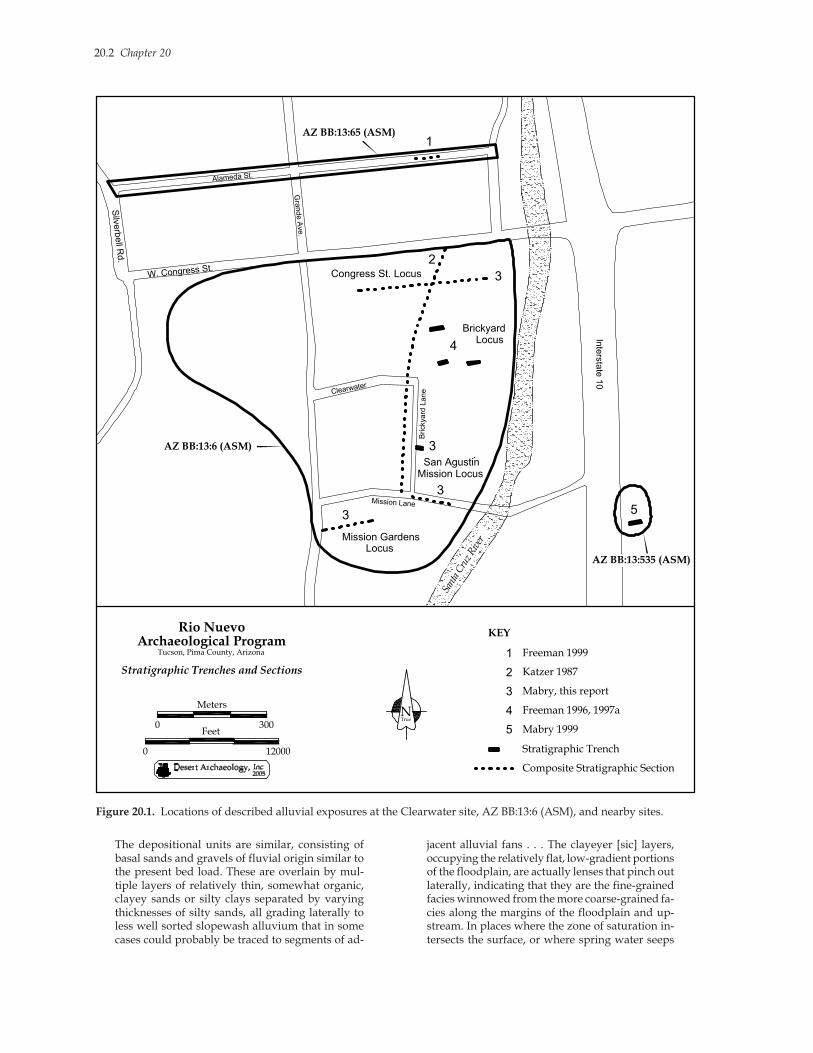
The alluvial deposits exposed in trenches at theClearwater site, AZ BB:13:6 (ASM), during the RioNuevo Archaeology project can be related to allu-vial deposits identified in several previous trenchesexcavated in the Holocene floodplain of the SantaCruz River, on the western side of the present chan-nel below A-Mountain (Ahlstrom et al. 1994; Freeman1996, 1997a, 1997b, 1999; Katzer 1987). The locationsof the alluvial exposures discussed here are shownin Figure 20.1. The deposits documented in previousexposures were correlated at a general level by Free-man (1997b). Mabry (1999) subsequently developeda more detailed, but still preliminary model of thestratigraphy of the floodplain west of the river tocompare it with the alluvial stratigraphy identifiedeast of the present channel at the East Bank site, AZBB:13:535 (ASM). The new exposures of alluvium andadditional radiocarbon dates reported here allowrefinement of the stratigraphic model of the Holoceneterrace (T2 in McKittrick 1988) at the base of A-Moun-tain. This chapter provides a synthesis and interpre-tation of the information currently available.
GEOMORPHOLOGY
Geomorphic processes in the area of the SantaCruz River floodplain in downtown Tucson arestrongly influenced by geology, topography, andvalley geometry. Except during intervals when thechannel is a continuous arroyo in this reach—as it iscurrently—a barrier of volcanic bedrock, of whichA-Mountain is the only visible portion, forces theunderground flow of the river to the surface (Betan-court and Turner 1990). At this location, the river isalso constricted between alluvial fans derived fromthe Tucson Mountains to the west and Pleistocene-aged terraces to the east. Throughout the Holocene,these conditions have typically led to sediment stor-age and a high water table south of A-Mountain, and,north of it, a steeply downsloping floodplain domi-nated by sediment transport (Parker 1995). DuringHolocene intervals of floodplain aggradation, thegradient of the floodplain slope downstream of A-Mountain gradually increased until it became sus-ceptible to channel incision.
These characteristics have made this a locus ofmultiple cycles of channel incision throughout theHolocene, with the most recent downcutting occur-ring during the 1890s (Cooke and Reeves 1976). Dur-ing the last incision cycle, the channel reached alayer of indurated Pleistocene sediments. Since then,it has been widening during floods, leading gov-ernmental agencies to stabilize the banks with con-crete in several reaches during the 1980s and 1990s.Within the wide channel, small terraces haveformed, including the T1 terrace in McKittrick(1988). Vegetation is currently increasing in thechannel bottom, trapping sediments and promot-ing channel filling.
Previous studies of exposures of alluvium in themiddle Santa Cruz Valley (the portion within theTucson Basin) have identified earlier cycles of chan-nel cutting and filling, with at least six major cyclesduring the last 5,000 years (Freeman 1996, 1997a,1997b, 1998, 1999, 2000a, 2000b; Gregory and Barr1999; Haynes and Huckell 1985, 1986; Huckell 1998;Huckleberry 2006; Katzer 1987, 1989; Mabry 1999;Nials 2006; Stafford 1987; Waters 1987, 1988). The 265radiocarbon dates reported in these studies, in addi-tion to the 36 dates reported here, provide the mostdetailed alluvial chronology in the Greater Southwestto date, particularly for the last 4,000 years (in un-calibrated radiocarbon years before present, ex-pressed here as 14C years b.p.).
These radiocarbon dates, along with temporallydiagnostic artifact types, bracket the ages of identi-fied alluvial deposits and indicate a pattern of longintervals of deposition interrupted by relatively briefintervals of channel entrenchment. These channelsfilled rapidly (within 100 years or so), and their fillscontain similar sediment sequences. Coarse sandsand gravels in the lower levels generally fine upwardto silts and clays in the higher levels. The uppermostsediments filling paleochannels are often thick claysthat were deposited in wet meadows (ciénegas inSpanish) created by high water tables (Hendricksonand Minckley 1984). Haynes and Huckell (1986:26-27) provided what is still the most concise descrip-tion of the typical sediment sequences within thechannel fills and the associated geomorphic pro-cesses:
CHAPTER 20
GEOMORPHOLOGY AND STRATIGRAPHY
Jonathan B. MabryDesert Archaeology, Inc.
20.2 Chapter 20
The depositional units are similar, consisting ofbasal sands and gravels of fluvial origin similar tothe present bed load. These are overlain by mul-tiple layers of relatively thin, somewhat organic,clayey sands or silty clays separated by varyingthicknesses of silty sands, all grading laterally toless well sorted slopewash alluvium that in somecases could probably be traced to segments of ad-
jacent alluvial fans . . . The clayeyer [sic] layers,occupying the relatively flat, low-gradient portionsof the floodplain, are actually lenses that pinch outlaterally, indicating that they are the fine-grainedfacies winnowed from the more coarse-grained fa-cies along the margins of the floodplain and up-stream. In places where the zone of saturation in-tersects the surface, or where spring water seeps
Sant
a C
ruz
Riv
er
Silv
erb
ell R
d.
W. Congress St.
Inte
rsta
te 1
0
Mission Lane
Brickyard
Lane
Alameda St.
Gra
nde A
ve.
Clearwater
AZ BB:13:6 (ASM)
AZ BB:13:65 (ASM)
AZ BB:13:535 (ASM)
TrueN
Rio Nuevo Archaeological Program
Tucson, Pima County, Arizona
Stratigraphic Trenches and Sections
0
Feet0
Meters
12000
300
Stratigraphic Trench
Composite Stratigraphic Section
1
2
3
4
3
3
3 5
1
2
3
4
5
Freeman 1999
Katzer 1987
Mabry, this report
Freeman 1996, 1997a
Mabry 1999
KEY
Congress St. Locus
BrickyardLocus
San Agustin
Mission Locus
Mission GardensLocus
Figure 20.1. Locations of described alluvial exposures at the Clearwater site, AZ BB:13:6 (ASM), and nearby sites.
Geomorphology and Stratigraphy 20.3
onto the floodplain, cienegas, or wet meadows,occur. Anytime the floodplain is not actively ag-grading or being eroded, soil development takesplace as vegetation grows and helps stabilize thesurface by a combination of root growth, reducingthe velocity of overflowing water, and trappingsediment. The top of each major depositional unit,where adequately preserved, has a soil indicatinga longer period of pedogenesis and stability thanany of the soils buried within the units, but the timeof stability and soil development must be relativelyshort compared to the time of aggradation.
The sequence of Holocene alluvium at the baseof A-Mountain also contains numerous flood depos-its. Some flood sediments are thin bands of silt, rep-resenting slackwater deposits that settled out ofslow-moving or ponded water during floods of mi-nor and moderate magnitudes, while others aremassive sandy deposits, more than a meter thick,representing channel deposits laid rapidly by fast-moving water during major flood events. Still othersare sands several meters in thickness that show bed-ding. These represent multiple high-magnitudefloods closely spaced in time. The alluvial sequenceshows that the last 4,000 years have been predomi-nated by regular overbank floods depositing silts andrapidly building the floodplain. The thick cienegaclays, representing long intervals of low-energy depo-sition, also contain multiple thin bands of silt andsand representing frequent minor flood events.
Alluvial Units
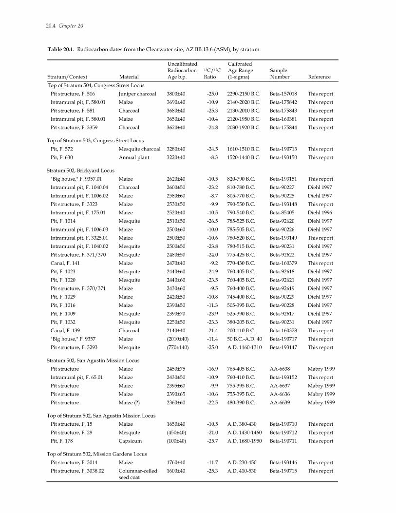
The current Holocene alluvial chronology of theA-Mountain reach of the Santa Cruz River floodplainis based on 36 radiocarbon dates presented in Tables20.1 and 20.2 (this total does not include five datesrejected as unreliable, shown in parentheses). Thealluvial units identified in trench exposures in vari-ous locations on the western and eastern sides of thecurrent river channel are correlated in Table 20.3.Twelve distinct units represent the entire 11,000-14C-year span of the Holocene and are designated herefor the first time. The ages of the units younger thanabout 4,000 14C years are estimated from associatedradiocarbon dates and temporally diagnostic arti-facts. The ages of older units are estimated throughcorrelations with radiocarbon-dated units in otherreaches. The alluvial units in the A-Mountain reachand their estimated timespans fit well (consistentlywithin 100 years) with the estimated beginning andending dates of the units identified for the entiremiddle Santa Cruz Valley by Haynes and Huckell(1986). However, the correlations suggested here maybe revised with additional information.
Unit 1
The oldest alluvial deposits identified in the A-Mountain reach are cross-bedded gravels and sandswith manganese staining 4-5 m below the presentground surface on the eastern side of the river at theEast Bank site (Units XVI-XIV, in ascending and tem-poral order; Mabry 1999). These represent braidingchannels of the river during an interval of rapid flow,probably dating to the terminal Pleistocene and earlyHolocene, sometime between 11,000 and 8,000 14Cyears b.p. No equivalents of these deposits have beenidentified on the western side of the river at the Clear-water site. However, similar deposits thought to dateto this time frame have been documented to the south(upstream) at the San Xavier Bridge site, AZ BB:13:14(ASM) (Waters 1987), and in Airport Wash (Units A1-3 in Haynes and Huckell 1986). Braiding channeldeposits possibly of this age have also been identi-fied downstream at the Santa Cruz Bend site, AZAA:12:746 (Unit 1a in Huckell 1998). Alternatively,this unit may date to the early portion of the middleHolocene, possibly during some interval between8000 and 6000 14C years b.p.
Unit 2
At the East Bank site, Unit 1 channel deposits areoverlain by 2 m of sands, sandy silts, and clayey silts(Units XIII-IX in Mabry 1999), representing threecycles of overbank deposition preceded and followedby deposition of colluvium derived from the nexthighest terrace to the east—the final Late PleistoceneJaynes terrace of Smith (1938). Lenses of colluviumare also present in these predominately overbankdeposits. Numerous calcium carbonate filaments andareas of heavy manganese staining indicate highgroundwater levels after deposition, but in the dis-tant past. No equivalents of these deposits have beenidentified on the western side of the river at Clear-water, or in any other reach in the middle Santa CruzValley. These deposits are estimated to date to thelate portion of the middle Holocene (6000-5000 14Cyears b.p.?), an interval during which channel depo-sition or high-energy overbank deposition was alsooccurring at the downstream at the Santa Cruz Bend;Las Capas, AZ AA:12:111 (ASM); and Los Morteros,AZ AA:12:57 (ASM), sites (Huckell 1998; Katzer 1989;Nials 2006), while channel cutting and widening wasoccurring upstream at San Xavier Bridge (Waters 1987).
Unit 3
The next higher unit at the East Bank site is com-posed of two silty clays deposited by overbank floodsand modified by pedogenesis and bioturbation (Units
20.4 Chapter 20
Table 20.1. Radiocarbon dates from the Clearwater site, AZ BB:13:6 (ASM), by stratum.
Stratum/Context Material
Uncalibrated Radiocarbon Age b.p.
13C/12C Ratio
Calibrated Age Range (1-sigma)
Sample Number Reference
Top of Stratum 504, Congress Street Locus
Pit structure, F. 516 Juniper charcoal 3800±40 -25.0 2290-2150 B.C. Beta-157018 This report
Intramural pit, F. 580.01 Maize 3690±40 -10.9 2140-2020 B.C. Beta-175842 This report
Pit structure, F. 581 Charcoal 3680±40 -25.3 2130-2010 B.C. Beta-175843 This report
Intramural pit, F. 580.01 Maize 3650±40 -10.4 2120-1950 B.C. Beta-160381 This report
Pit structure, F. 3359 Charcoal 3620±40 -24.8 2030-1920 B.C. Beta-175844 This report
Top of Stratum 503, Congress Street Locus
Pit, F. 572 Mesquite charcoal 3280±40 -24.5 1610-1510 B.C. Beta-190713 This report
Pit, F. 630 Annual plant 3220±40 -8.3 1520-1440 B.C. Beta-193150 This report
Stratum 502, Brickyard Locus
"Big house," F. 9357.01 Maize 2620±40 -10.5 820-790 B.C. Beta-193151 This report
Intramural pit, F. 1040.04 Charcoal 2600±50 -23.2 810-780 B.C. Beta-90227 Diehl 1997
Intramural pit, F. 1006.02 Maize 2580±60 -8.7 805-770 B.C. Beta-90225 Diehl 1997
Pit structure, F. 3323 Maize 2530±50 -9.9 790-550 B.C. Beta-193148 This report
Intramural pit, F. 175.01 Maize 2520±40 -10.5 790-540 B.C. Beta-85405 Diehl 1996
Pit, F. 1014 Mesquite 2510±50 -26.5 785-525 B.C. Beta-92620 Diehl 1997
Intramural pit, F. 1006.03 Maize 2500±60 -10.0 785-505 B.C. Beta-90226 Diehl 1997
Intramural pit, F. 3325.01 Maize 2500±50 -10.6 780-520 B.C. Beta-193149 This report
Intramural pit, F. 1040.02 Mesquite 2500±50 -23.8 780-515 B.C. Beta-90231 Diehl 1997
Pit structure, F. 371/370 Mesquite 2480±50 -24.0 775-425 B.C. Beta-92622 Diehl 1997
Canal, F. 141 Maize 2470±40 -9.2 770-430 B.C. Beta-160379 This report
Pit, F. 1023 Mesquite 2440±60 -24.9 760-405 B.C. Beta-92618 Diehl 1997
Pit, F. 1020 Mesquite 2440±60 -23.5 760-405 B.C. Beta-92621 Diehl 1997
Pit structure, F. 370/371 Maize 2430±60 -9.5 760-400 B.C. Beta-92619 Diehl 1997
Pit, F. 1029 Maize 2420±50 -10.8 745-400 B.C. Beta-90229 Diehl 1997
Pit, F. 1016 Maize 2390±50 -11.3 505-395 B.C. Beta-90228 Diehl 1997
Pit, F. 1009 Mesquite 2390±70 -23.9 525-390 B.C. Beta-92617 Diehl 1997
Pit, F. 1032 Mesquite 2250±50 -23.3 380-205 B.C. Beta-90231 Diehl 1997
Canal, F. 139 Charcoal 2140±40 -21.4 200-110 B.C. Beta-160378 This report
"Big house," F. 9357 Maize (2010±40) -11.4 50 B.C.-A.D. 40 Beta-190717 This report
Pit structure, F. 3293 Mesquite (770±140) -25.0 A.D. 1160-1310 Beta-193147 This report
Stratum 502, San Agustín Mission Locus
Pit structure Maize 2450±75 -16.9 765-405 B.C. AA-6638 Mabry 1999
Intramural pit, F. 65.01 Maize 2430±50 -10.9 760-410 B.C. Beta-193152 This report
Pit structure Maize 2395±60 -9.9 755-395 B.C. AA-6637 Mabry 1999
Pit structure Maize 2390±65 -10.6 755-395 B.C. AA-6636 Mabry 1999
Pit structure Maize (?) 2360±60 -22.5 480-390 B.C. AA-6639 Mabry 1999
Top of Stratum 502, San Agustín Mission Locus
Pit structure, F. 15 Maize 1650±40 -10.5 A.D. 380-430 Beta-190710 This report
Pit structure, F. 28 Mesquite (450±40) -21.0 A.D. 1430-1460 Beta-190712 This report
Pit, F. 178 Capsicum (100±40) -25.7 A.D. 1680-1950 Beta-190711 This report
Top of Stratum 502, Mission Gardens Locus
Pit structure, F. 3014 Maize 1760±40 -11.7 A.D. 230-450 Beta-193146 This report
Pit structure, F. 3038.02 Columnar-celled seed coat
1600±40 -25.3 A.D. 410-530 Beta-190715 This report

Geomorphology and Stratigraphy 20.5
VIII and VII in Mabry 1999). The lower paleosol av-erages approximately 30 cm in thickness, and theupper paleosol is about 50 cm thick in most places.These units, referred to here as Units 3a and 3b, rep-resent intervals of overbank deposition, interruptedby periods of floodplain stability and surface weath-ering, that may correlate with cycles of incision ofthe main river channel. Temporally, this unit appearsto correlate with the Unit B1 colluvium depositedalong the edge of the river channel (Unit B1) in theupstream reach south of San Xavier, with associatedradiocarbon dates ranging between 4850 and 398014C years b.p., and containing Middle Archaic sites(Haynes and Huckell 1986).
Unit 4
Unit 4 represents an interval of rapid deposition,beginning with flood sands or near-channel sands(4a), then shifting to overbank silts and clays (4b).Associated radiocarbon dates bracket the total time-span of Unit 4 between about 4000 and 3000 14C yearsb.p. This unit is approximately equivalent to Unit B2in Haynes and Huckell (1986), which was initiatedby a cycle of channel cutting documented in otherreaches of the middle Santa Cruz floodplain. Noequivalent channel has been identified at the base ofA-Mountain, although erosion of the top of Unit 3may be related to local channel entrenchment.
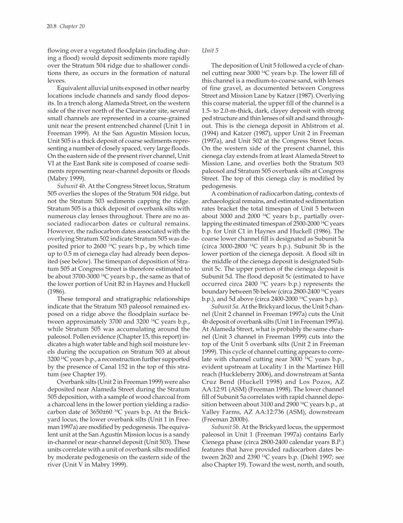
Subunit 4a. On the western side of the current riverchannel, south of Congress Street, strata 504 and 503(both within Unit 4a) are coarse, sandy deposits laiddown by high-velocity water flows in and near thechannel. The surface of Stratum 504, the earliest de-posit in this unit, is not level. It forms a low, gentlysloping ridge trending southwest-northeast (Figure20.2). The southeastern side slopes more steeply thanthe northwestern side. The orientation, distribution,and size of this deposit suggest it formed subaque-ously, as a channel-margin or current-margin barduring a relatively large flood event. Trenches didnot extend to the bottom of the deposit; therefore,the presence of an actual channel incised into the
floodplain is speculative. The channel (or current)appears to have been meandering, and the Stratum504 ridge appears to have been deposited as a bar-like feature on the outside of the meander. This pos-tulated origin would explain the elevated nature ofthe surface and the steeper southeastern side, as wellas the coarse nature of the sediments. The sandy sedi-ments are highly oxidized, with an orange color.Cultural features excavated into the top of this unitprovided five radiocarbon dates ranging between3800 and 3620 14C years b.p., including two dates onmaize of 3690±40 and 3650±40 14C years b.p. (Chap-ter 19, this report).
The sediments of the overlying Stratum 503 arealmost identical to Stratum 504, except they are notoxidized and have been modified by moderate pe-dogenesis. Stratum 503 is relatively thin and appearsto be thickest over the Stratum 504 crest, draping overthe ridge and thinning toward its margins (see Fig-ure 20.2). The contact between strata 503 and 504 iseasily recognized, but appears to have been “blurred”by postdepositional bioturbation processes. There areno indications of significant pedogenesis on Stratum504 prior to Stratum 503 deposition, although thepresence of cultural features and artifacts on the sur-face of Stratum 504 implies that it was exposed for aperiod of time. Cultural features originating in Stra-tum 503 provided two radiocarbon dates of 3280±40and 3220±40 14C years b.p., the latter on annual plantremains (see Chapter 19).
The lack of pedogenesis on top of Stratum 504indicates the hiatus between depositions of strata 504and 503 was relatively short, while the radiocarbondates associated with Stratum 503 cultural featuresindicate they were dug into its surface several centu-ries after its deposition. In addition to the lack of pe-dogenesis on Stratum 504, the absence of subaerialerosional features (rills, dunes, and so forth) and theabsence of eolian sorting of the sandy Stratum 504deposits all support the scenario that Stratum 503 wasdeposited subaqueously, not long after the deposi-tion of Stratum 504. This would explain the morphol-ogy and texture of Stratum 503 sediments. Water
Table 20.2. Relevant radiocarbon dates from sites near the Clearwater site, AZ BB:13:6 (ASM), by alluvial unit.
Stratum/Context Material
Uncalibrated Radiocarbon Age b.p.
13C/12C Ratio
Calibrated Age Range (1-sigma)
Sample Number Reference
Subunit 4b: Alameda Street Locus [Unit 2 at AZ BB:13:65 (ASM)]
Charcoal lens Unidentified charcoal 3650±60 ? 2130-1940 B.C. Beta-85537 Freeman 1999
Subunit 5d: East Bank Site [Upper Unit IV at AZ BB:13:535 (ASM)]
Pit, Feature 67 Mesquite charcoal 2420±80 -25.0 760-400 B.C. Beta-119021 Mabry 1999
20.6 Chapter 20
Ta
ble
20.
3.
Co
nco
rdan
ce t
able
fo
r id
enti
fied
all
uv
ial
un
its
in t
he
San
ta C
ruz
Riv
er f
loo
dp
lain
at
the
bas
e o
f A
-Mo
un
tain
.
Lo
cati
on
s o
f E
xp
osu
res
Wes
tern
Sid
e, A
Z B
B:1
3:6
(AS
M)
, an
d A
Z B
B:1
3:65
(A
SM
) E
aste
rn S
ide,
AZ
B
B:1
3:53
5 (A
SM
)
Ala
med
a S
tree
t (F
reem
an 1
999)
Co
ng
ress
Str
eet
(T
his
rep
ort
)
Bri
cky
ard
(F
reem
an 1
997a
)
San
Ag
ust
ín M
issi
on
(T
his
rep
ort
)
Mis
sio
n G
ard
ens
(Th
is r
epo
rt)
E
ast
Ban
k
(Mab
ry 1
999)
A-M
ou
nta
in
Ho
loce
ne A
llu
via
l U
nit
s a
nd
Est
ima
ted
T
ime
spa
ns
(Un
cali
bra
ted
1
4C
Years
b.p
.)
Mid
dle
San
ta
Cru
z V
alle
y
Un
its
(H
ayn
es a
nd
H
uck
ell
1986
)
Pre
sen
t ch
ann
el
P
rese
nt
chan
nel
Pre
sen
t ch
ann
el
P
rese
nt
chan
nel
Pre
sen
t ch
ann
el
P
rese
nt
chan
nel
9
1
00
-pre
sen
t
E
6, H
isto
ric
plo
wzo
ne
49
8, C
ien
ega/
Plo
wzo
ne
4.
His
tori
c fi
lls
49
7, P
low
zon
e
499,
Up
per
(so
il)
IA
, U
pp
er (
ov
erb
ank
si
lts)
8
2
00
-10
0
D
499,
Cie
neg
a
5, U
pp
er c
han
nel
fil
l
t
run
cate
d
499,
Lo
wer
(si
lts)
IA,
Lo
wer
(o
ver
ban
k
silt
s)
7b
9
00
-20
0
C
3
5, C
ha
nn
el f
ill
50
0, C
han
nel
fil
l
5, L
ow
er c
ha
nn
el f
ill
by
50
0, F
loo
d s
and
s
IB, F
loo
d s
and
s 7
a
10
00
-900
C3
501,
Up
per
(ci
eneg
a)
3,
Up
per
(ci
eneg
a)
plo
wzo
ne
501,
Flo
od
sil
t an
d
irri
gat
ion
cla
y
II
, Up
per
(ci
eneg
a)
6c
11
00
-10
00
C2
4, O
ver
ban
k s
ilts
501,
Mid
dle
(o
ver
ban
k
silt
s)
3,
Mid
dle
ch
ann
el f
ill
50
1, S
oil
II, L
ow
er (
ov
erb
ank
si
lts)
6
b
18
00
-11
00
C2
di
scon
form
ity
501,
Lo
wer
(ch
ann
el
gra
vel
s)
3,
Lo
wer
ch
an
nel
fil
l
501,
Flo
od
san
ds
II
I, F
loo
d s
and
s 6
a
20
00
-180
0
C
2
3, U
pp
er (
cien
ega)
502,
Up
per
(ci
eneg
a)
2,
Up
per
(ci
eneg
a)
50
2, U
pp
er (
cien
ega)
502,
Up
per
(ci
eneg
a)
IV
, U
pp
er (
cien
ega)
5
d
24
00
-20
00
C1
502,
Mid
dle
(fl
oo
d)
50
2, M
idd
le (
flo
od
)
5
c c
a. 2
40
0
C
1
502,
Lo
wer
(ci
eneg
a)
1,
Up
per
so
ils
50
2, L
ow
er (
cien
ega)
502,
Lo
wer
(ci
eneg
a)
IV
, Lo
wer
(ci
eneg
a)
5b
2
80
0-2
40
0
C1
3, L
ow
er (
chan
nel
fil
l)
2, L
ow
er (
chan
nel
fil
l)
5
a
30
00
-280
0
C
1
2, O
ver
ban
k s
ilts
505,
Ov
erb
ank
sil
ts
1,
Ov
erb
ank
sil
ts
50
3, F
loo
d s
and
s
V, O
ver
ban
k s
ilts
4
b
37
00
-30
00
B2
1, M
ult
iple
ch
ann
els
50
4-50
3, F
loo
d b
ar
50
5, F
loo
d s
and
s
VI,
Flo
od
san
ds
4a
4
00
0-3
700
B2
V
III-
VII
,So
ils
3a
-b 5
00
0-4
000
B1
X
III-
IX,S
ilts
and
coll
uv
ium
2
Mid
dle
Ho
loce
ne
X
VI-
XIV
,B
raid
ing
chan
nel
s
1 E
arl
y H
olo
cen
e-
term
ina
l P
leis
toce
ne
A
No
te: B
old
tex
t in
dic
ates
all
uv
ial
un
its
and
tim
esp
ans
refe
rred
to
in
th
is r
epo
rt.

Geomorphology and Stratigraphy 20.7
Figure 20.2. Topographies of the tops of Stratum 503 and Stratum 504 at the Congress Street locus, the Clearwatersite, AZ BB:13:6 (ASM).
20.8 Chapter 20
flowing over a vegetated floodplain (including dur-ing a flood) would deposit sediments more rapidlyover the Stratum 504 ridge due to shallower condi-tions there, as occurs in the formation of naturallevees.
Equivalent alluvial units exposed in other nearbylocations include channels and sandy flood depos-its. In a trench along Alameda Street, on the westernside of the river north of the Clearwater site, severalsmall channels are represented in a coarse-grainedunit near the present entrenched channel (Unit 1 inFreeman 1999). At the San Agustín Mission locus,Unit 505 is a thick deposit of coarse sediments repre-senting a number of closely spaced, very large floods.On the eastern side of the present river channel, UnitVI at the East Bank site is composed of coarse sedi-ments representing near-channel deposits or floods(Mabry 1999).
Subunit 4b. At the Congress Street locus, Stratum505 overlies the slopes of the Stratum 504 ridge, butnot the Stratum 503 sediments capping the ridge.Stratum 505 is a thick deposit of overbank silts withnumerous clay lenses throughout. There are no as-sociated radiocarbon dates or cultural remains.However, the radiocarbon dates associated with theoverlying Stratum 502 indicate Stratum 505 was de-posited prior to 2600 14C years b.p., by which timeup to 0.5 m of cienega clay had already been depos-ited (see below). The timespan of deposition of Stra-tum 505 at Congress Street is therefore estimated tobe about 3700-3000 14C years b.p., the same as that ofthe lower portion of Unit B2 in Haynes and Huckell(1986).
These temporal and stratigraphic relationshipsindicate that the Stratum 503 paleosol remained ex-posed on a ridge above the floodplain surface be-tween approximately 3700 and 3200 14C years b.p.,while Stratum 505 was accumulating around thepaleosol. Pollen evidence (Chapter 15, this report) in-dicates a high water table and high soil moisture lev-els during the occupation on Stratum 503 at about3200 14C years b.p., a reconstruction further supportedby the presence of Canal 152 in the top of this stra-tum (see Chapter 19).
Overbank silts (Unit 2 in Freeman 1999) were alsodeposited near Alameda Street during the Stratum505 deposition, with a sample of wood charcoal froma charcoal lens in the lower portion yielding a radio-carbon date of 3650±60 14C years b.p. At the Brick-yard locus, the lower overbank silts (Unit 1 in Free-man 1997a) are modified by pedogenesis. The equiva-lent unit at the San Agustín Mission locus is a sandyin-channel or near-channel deposit (Unit 503). Theseunits correlate with a unit of overbank silts modifiedby moderate pedogenesis on the eastern side of theriver (Unit V in Mabry 1999).
Unit 5
The deposition of Unit 5 followed a cycle of chan-nel cutting near 3000 14C years b.p. The lower fill ofthis channel is a medium-to-coarse sand, with lensesof fine gravel, as documented between CongressStreet and Mission Lane by Katzer (1987). Overlyingthis coarse material, the upper fill of the channel is a1.5- to 2.0-m-thick, dark, clayey deposit with strongped structure and thin lenses of silt and sand through-out. This is the cienega deposit in Ahlstrom et al.(1994) and Katzer (1987), upper Unit 2 in Freeman(1997a), and Unit 502 at the Congress Street locus.On the western side of the present channel, thiscienega clay extends from at least Alameda Street toMission Lane, and overlies both the Stratum 503paleosol and Stratum 505 overbank silts at CongressStreet. The top of this cienega clay is modified bypedogenesis.
A combination of radiocarbon dating, contexts ofarchaeological remains, and estimated sedimentationrates bracket the total timespan of Unit 5 betweenabout 3000 and 2000 14C years b.p., partially over-lapping the estimated timespan of 2500-2000 14C yearsb.p. for Unit C1 in Haynes and Huckell (1986). Thecoarse lower channel fill is designated as Subunit 5a(circa 3000-2800 14C years b.p.). Subunit 5b is thelower portion of the cienega deposit. A flood silt inthe middle of the cienega deposit is designated Sub-unit 5c. The upper portion of the cienega deposit isSubunit 5d. The flood deposit 5c (estimated to haveoccurred circa 2400 14C years b.p.) represents theboundary between 5b below (circa 2800-2400 14C yearsb.p.), and 5d above (circa 2400-2000 14C years b.p.).
Subunit 5a. At the Brickyard locus, the Unit 5 chan-nel (Unit 2 channel in Freeman 1997a) cuts the Unit4b deposit of overbank silts (Unit 1 in Freeman 1997a).At Alameda Street, what is probably the same chan-nel (Unit 3 channel in Freeman 1999) cuts into thetop of the Unit 5 overbank silts (Unit 2 in Freeman1999). This cycle of channel cutting appears to corre-late with channel cutting near 3000 14C years b.p.,evident upstream at Locality 1 in the Martinez Hillreach (Huckleberry 2006), and downstream at SantaCruz Bend (Huckell 1998) and Los Pozos, AZAA:12:91 (ASM) (Freeman 1998). The lower channelfill of Subunit 5a correlates with rapid channel depo-sition between about 3100 and 2900 14C years b.p., atValley Farms, AZ AA:12:736 (ASM), downstream(Freeman 2000b).
Subunit 5b. At the Brickyard locus, the uppermostpaleosol in Unit 1 (Freeman 1997a) contains EarlyCienega phase (circa 2800-2400 calendar years B.P.)features that have provided radiocarbon dates be-tween 2620 and 2390 14C years b.p. (Diehl 1997; seealso Chapter 19). Toward the west, north, and south,
Geomorphology and Stratigraphy 20.9
this uppermost paleosol transitions laterally to thelower part of the Stratum 502 cienega clay (Unit 5b),and is overlain by the upper portion of Stratum 502(Unit 5d). At the San Agustín Mission locus, themiddle of the Stratum 502 cienega clay containsCienega phase features radiocarbon dated between2395 and 2360 14C years b.p. (Elson and Doelle 1987;dates reported in Mabry 1998a:Table 1.3). On theeastern side of the present channel at the East Banksite, the contact between Unit V overbank silts andthe overlying Unit IV cienega clay is modified bypedogenesis, but is gradational; these units may rep-resent lower and upper portions of the same depositrather than distinct strata (Mabry 1999). Early Cien-ega phase features originate at this contact and justabove it.
Subunit 5c. The Cienega phase features at the SanAgustín Mission locus originate on a surface that wassubsequently covered by a thin, sandy silt layer de-posited by a flood of minor to moderate magnitude,bracketed near 2400-2350 14C years b.p. by the agesof cultural features in underlying and overlying units.What is thought to be the same flood deposit wasalso visible in the middle of the Stratum 502 cienegaclay at the Mission Gardens locus.
Subunit 5d. The top of Subunit 5d, representing acontinuation of cienega conditions over a large area,can be dated to about 2000 14C years b.p., based onthe oldest cultural materials on it. Late Cienega phase(circa 2400-1950 calendar years B.P.) cultural featuresare dug into the top of the Stratum 502 cienega de-posit at the San Agustín Mission locus; a canal radio-carbon dated to roughly 2100 14C years b.p. is in theupper part of the Stratum 502 cienega clay at theBrickyard locus (this report), and sherds of the AguaCaliente phase (circa 1950-1450 calendar years B.P.)are in the upper portion of an equivalent cienega clayunit at Alameda Street (Unit 3 in Freeman 1999). Atthe East Bank site, Unit IV grades from silty clay toclayey silt (becoming a cienega deposit) westwardtoward the present channel. One of the Late Cienegaphase features originating in the upper portion of thisunit provided a radiocarbon date of 2420±80 14C yearsb.p. (Mabry 1999).
Unit 6
Deposition of Unit 6 followed a cycle of down-cutting near 2000 14C years b.p. The channel fill gradesupward from coarse channel gravels and sands (Sub-unit 6a), to overbank silts (Subunit 6b), to a cienegadeposit (Subunit 6c). Associated radiocarbon datesand temporally diagnostic ceramic types bracket thetotal timespan of deposition of Unit 6 between about2000 and 1000 14C years b.p., equivalent to Unit C2in Haynes and Huckell (1986).
Subunit 6a. At Congress Street, the Stratum 501channel cuts the Stratum 502 cienega clay. At theBrickyard locus, the Unit 3 channel cuts the cienegaclay in the upper part of Unit 2 (Freeman 1997a). Atthe San Agustín Mission locus, the Stratum 502cienega clay is overlain by an in-channel or near-chan-nel sand deposit (Unit 501). The intervals of Subunits6a and 6b are represented by an erosional surface atthe Mission Gardens. On the eastern side of thepresent channel, a laminated deposit of sandy in-channel or near-channel sediments (Unit III) tops thecienega deposit in the upper part of Unit IV (Mabry1999). Channel deposition following entrenchmentprobably lasted no longer than a couple of centuries,and the estimated timespan of Subunit 6a is circa2000-1800 14C years b.p.
Subunit 6b. Filling of the lower part of the Unit 6channel with coarse sediments was followed by over-bank deposition of finer sediments. Overbank siltsof Unit 4 overlie the Unit 3 cienega clay at AlamedaStreet (Freeman 1999). At Congress Street, the middlechannel fill of Stratum 501 is composed of bands ofsilts and clays. During this interval, a weak soilformed in the upper part of Unit 501 at the SanAgustín Mission locus. At the Mission Gardens lo-cus, Agua Caliente phase cultural features radiocar-bon dated to 1760±40 and 1600±40 14C years b.p. wereexcavated into the eroded top of the Stratum 502cienega deposit during a hiatus in deposition at thatlocation. The corresponding lower part of Unit II onthe eastern side of the present channel is a clayey siltdeposited by overbank floods and containing culturalfeatures of the Cañada del Oro phase (circa 1250-1150calendar years B.P.) (Mabry 1999).
Subunit 6c. The upper part of the Unit 6 channelfill at Congress Street (this report) and at the Brick-yard locus (upper Unit 3 in Freeman 1997a) is a 30-to 50-cm-thick cienega clay displaying weak pedo-genesis. At the Brickyard locus, pottery sherds of theEarly and Middle Rincon subphases (circa 1050-900calendar years B.P.) are contained in this cienegadeposit (Freeman 1997a). Canal 146, containing pot-tery sherds of the Late Rincon and Tanque Verdephases (circa 900-700 14C years b.p.), is cut into thetop of it. At the San Agustín Mission locus, Canal137 was probably excavated during the interval ofSubunit 6c, but the top of the canal and the surround-ing alluvial sediments deposited during this inter-val are truncated by the historic plowzone. At theMission Gardens locus, a flood silt was depositedafter Canal 200 was excavated, followed by deposi-tion of a thin sheet of clay that probably derived fromthe irrigation water delivered by this canal. Formingthe upper part of Unit 2 on the eastern side of thepresent channel is a cienega clay displaying weakpedogenesis (Mabry 1999). Hohokam cultural features
20.10 Chapter 20
dating to the Middle Rincon subphase (circa 1000-900 calendar years B.P.) are contained in this cienegadeposit, and cultural features of the Late Rincon sub-phase (circa 900-850 calendar years B.P.) intrude thetop of it (Mabry 1999).
Unit 7
Deposition of Unit 7 follows a cycle of channelcutting near 1000 14C years b.p., equivalent to thechannel-cutting cycle near that time in several otherreaches of the middle Santa Cruz Valley (Unit C3channel in Haynes and Huckell 1986). Associatedradiocarbon dates and temporally diagnostic ceramictypes bracket the total timespan of deposition of Unit7 from about 1000 14C years b.p. to sometime between300 and 200 calendar years B.P., equivalent to UnitC3 in Haynes and Huckell (1986).
Subunit 7a. At Alameda Street, the small Unit 5channel cut into the top of the Unit 4 overbank silts.Freeman (1999) suggests this channel may be theditch excavated at Saint Mary’s Road in 1888, whichbecame the initial locus of arroyo headcutting thefollowing year (Betancourt and Turner 1990). How-ever, at Congress Street, a similar-sized (7-8 m wide),sand-filled channel (Stratum 500) cut through thecienega clay in the upper portion of Stratum 501, anda sequence of two Hohokam canals (Features 146 and154) containing sherds of the Late Rincon and TanqueVerde phases (circa 900-700 calendar years B.P.) weresubsequently excavated within this sand-filled chan-nel.
At Alameda Street, Freeman (1999:Figure 2.3)identified two historic canals in the top of the Unit5 channel fill. The historic-era Canal D (Feature 180)documented by Freeman (1996) at the Brickyard lo-cus was also excavated into a sandy channel depositcontaining pottery sherds of the Early and MiddleRincon subphases (circa 1050-900 calendar yearsB.P.). These stratigraphic relationships and associateddatable artifacts indicate the channel cutting occurrednear 1000 calendar years B.P. The channel deposi-tion represented by Subunit 7a is bracketed betweenabout 1000 and 900 calendar years B.P. by the agesof cultural features contained in the underlying andoverlying units (see above and below).
The corresponding unit at the Mission Gardensis a massive deposit of flood sands (Stratum 500) thatfilled Canal 200 and terminated its use. At the SanAgustín Mission locus, historic plowing truncated thesediments deposited during this interval, but theflood deposit that filled the upper portion of Canal137 may correlate with the flood sands at the Mis-sion Gardens. These flood deposits on the westernside of the present river channel correlate with theUnit IB flood sands on the eastern side (Mabry 1999).
Subunit 7b. The top of the Unit 7 channel fill (up-per Stratum 499) at Congress Street is a cienega clay.This deposit formed during the use of Canal 149,draping down into the canal profile. The sedimentsfilling this canal contained a variety of Classic pe-riod sherds, including Tanque Verde Red-on-brown,Sells Red, and corrugated wares, bracketing its agebetween about 850 and 700 calendar years B.P. Aflood sand filled Canal 149 and terminated its use.Canal 151 also appears to have been excavatedthrough the upper Stratum 501 cienega clay duringthis interval. The Subunit 7b cienega is equivalent tothe upper channel fills of Unit 5 at both AlamedaStreet and the Brickyard locus (Freeman 1997a, 1999).The corresponding sediments at the San AgustínMission locus are truncated by historic plowing.During this interval, overbank silts (Stratum 499)were deposited at the Mission Gardens locus.
Protohistoric period canals 201, 204, 205, and207—dating between about 500 and 300 calendaryears B.P. (and possibly as late as 200 calendar yearsB.P.)—originated within the upper part of this unit.On the eastern side of the present river channel, thelower part of the overbank silts of Unit IA were de-posited; this unit contains cultural features of the LateRincon subphase (circa 900-850 calendar years B.P.)(Mabry 1999). Spanish period remains at the SanAgustín Mission lie on top of Unit 7b, indicatingdeposition of this unit stopped by 200 years ago. Theages of these archaeological features, and the ages ofthe underlying and overlying units, bracket the ageof Subunit 7b between about 900 and 200 calendaryears B.P.
Unit 8
Although no equivalent channel has been iden-tified in the area at the base of A-Mountain, deposi-tion of Unit 8 follows a cycle of channel cuttingsometime between 500 and 200 calendar years B.P.in several other reaches of the middle Santa CruzValley (Unit D channel in Haynes and Huckell 1986).Waters and Haynes (2001) place this channel-cuttingepisode near 500 years ago, but do not present thebasis of this dating. The presence of Protohistoriccanals within Unit 7b at the Mission Gardens seemsto indicate the Unit 8 channel cutting occurred some-time between 300 and 200 calendar years B.P., whilethe Spanish period remains of the San Agustín Mis-sion on top of Subunit 7b and contained in Unit 8sediments indicate Unit 8 began accumulating ap-proximately 200 years ago. At the Mission Gardensand Congress Street loci, Unit 8 contains Spanish,Mexican, and American Territorial period artifacts,features, and canals. These associated cultural re-mains suggest a timespan of about 200-100 calendar
Geomorphology and Stratigraphy 20.11
years B.P. for Unit 8, of which the upper portion hasbeen truncated by historic plowing.
At Congress Street, following a period of soil for-mation in the upper part of the flood sand that filledthe Hohokam canal Feature 149, historic canal Fea-ture 155 was excavated along the depression of theprehistoric canal. A cienega clay contemporaneouswith this historic canal extends toward the presentriver channel. West of Canal 155, the historic plow-zone truncates the upper portions of sediments andcanals dating to this interval. Nevertheless, it is ap-parent that historic canal Feature 147 was excavatedalong the same alignment as Hohokam Canals 146and 154, intruding their upper fills. Canal Feature138, shown on an 1862 map as the “Acequia MadrePrimera,” was also excavated during this interval.
At the Mission Gardens locus, the top of the Unit7b silts are modified by weak pedogenesis and partlytruncated by the historic plowzone. The plowzonealso truncated Unit 8 deposits at Alameda Street(Freeman 1999), while this unit contains cultural fillsdating to the nineteenth and twentieth centuries atthe Brickyard locus (Freeman 1997a). East of thepresent channel, the upper part of Unit IA containshistoric-era trash and is disturbed by modern con-struction activities; its top forms the present groundsurface.
Unit 9
The most recent cycle of channel cutting at theend of the nineteenth century is well documentedby local newspapers and photographers (Betancourtand Turner 1990). A ditch was excavated at St. Mary’sRoad in 1888 to intercept the river’s underflow toincrease the water supply to agricultural fields to thenorth. The following year, this ditch became the lo-cus of arroyo headcutting during a large summerflood. Large floods also occurred during the sum-mers of 1890 and 1891, and the arroyo starting atHugh’s ditch extended upstream (southward) alongthe Acequia Madre. The river channel downcut tothe water table lowered by previous years of droughtand overgrazing. By 1891, the arroyo had extendedsouth of A-Mountain. This headcut coalesced withanother downcut segment near the San Xavier Mis-sion by 1910, resulting in the continuous incised chan-nel through Tucson that is visible today.
Summary
This new model of the alluvial sequence for theSanta Cruz River’s former floodplain at the base ofA-Mountain allows a number of observations, con-clusions, and correlations. The estimated beginning
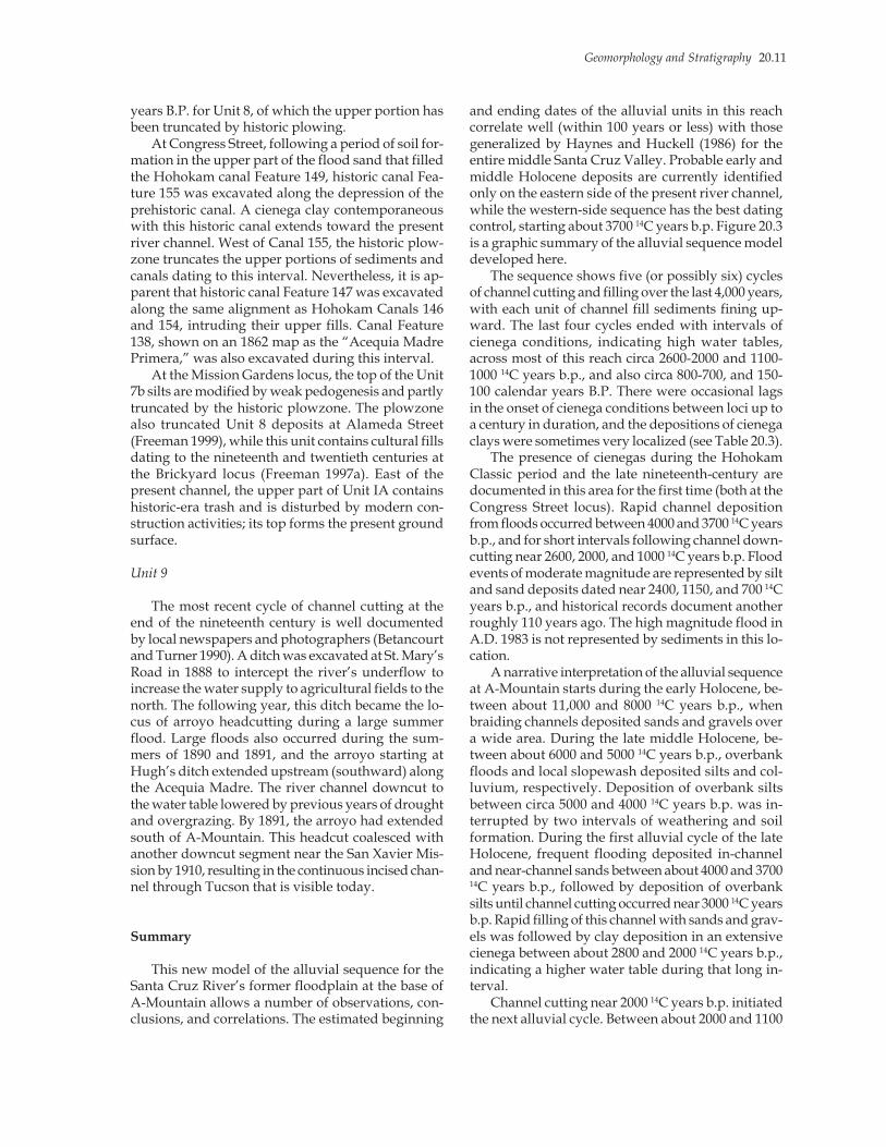
and ending dates of the alluvial units in this reachcorrelate well (within 100 years or less) with thosegeneralized by Haynes and Huckell (1986) for theentire middle Santa Cruz Valley. Probable early andmiddle Holocene deposits are currently identifiedonly on the eastern side of the present river channel,while the western-side sequence has the best datingcontrol, starting about 3700 14C years b.p. Figure 20.3is a graphic summary of the alluvial sequence modeldeveloped here.
The sequence shows five (or possibly six) cyclesof channel cutting and filling over the last 4,000 years,with each unit of channel fill sediments fining up-ward. The last four cycles ended with intervals ofcienega conditions, indicating high water tables,across most of this reach circa 2600-2000 and 1100-1000 14C years b.p., and also circa 800-700, and 150-100 calendar years B.P. There were occasional lagsin the onset of cienega conditions between loci up toa century in duration, and the depositions of cienegaclays were sometimes very localized (see Table 20.3).
The presence of cienegas during the HohokamClassic period and the late nineteenth-century aredocumented in this area for the first time (both at theCongress Street locus). Rapid channel depositionfrom floods occurred between 4000 and 3700 14C yearsb.p., and for short intervals following channel down-cutting near 2600, 2000, and 1000 14C years b.p. Floodevents of moderate magnitude are represented by siltand sand deposits dated near 2400, 1150, and 700 14Cyears b.p., and historical records document anotherroughly 110 years ago. The high magnitude flood inA.D. 1983 is not represented by sediments in this lo-cation.
A narrative interpretation of the alluvial sequenceat A-Mountain starts during the early Holocene, be-tween about 11,000 and 8000 14C years b.p., whenbraiding channels deposited sands and gravels overa wide area. During the late middle Holocene, be-tween about 6000 and 5000 14C years b.p., overbankfloods and local slopewash deposited silts and col-luvium, respectively. Deposition of overbank siltsbetween circa 5000 and 4000 14C years b.p. was in-terrupted by two intervals of weathering and soilformation. During the first alluvial cycle of the lateHolocene, frequent flooding deposited in-channeland near-channel sands between about 4000 and 370014C years b.p., followed by deposition of overbanksilts until channel cutting occurred near 3000 14C yearsb.p. Rapid filling of this channel with sands and grav-els was followed by clay deposition in an extensivecienega between about 2800 and 2000 14C years b.p.,indicating a higher water table during that long in-terval.
Channel cutting near 2000 14C years b.p. initiatedthe next alluvial cycle. Between about 2000 and 1100
20.12 Chapter 20
Figu
re 2
0.3.
Com
posi
te g
eolo
gic
cros
s se
ctio
n of
the
A-M
ount
ain
reac
h of
the
Sant
a C
ruz
Rive
r flo
odpl
ain.
canal
slo
pew
ash
canals
Holo
cene t
err
ace T
2
WE
ST
A-M
ou
nta
in
of
Early A
gricultura
l
curr
ent
EA
ST
his
toric
Cie
nega p
hase A
Z B
B:1
3:6
(A
SM
)
4a
5a
6b 6
a
4a
Hohokam
canals
his
toric
canal
4a
AZ
BB
:13:5
35 (
AS
M)
canal
pro
tohis
toric
Sa
nta
Cru
zchannel
5
4b
4a
1
2
slo
pew
ash
T3
T4
AZ
BB
:13:1
3 (
AS
M)
Ple
isto
cene
terr
aces
period c
anal
unnam
ed inte
rval
8 (
plo
wzo
ne)
(502 u
pp
er)
flo
od
(502 l
ow
er)
(503)
(504)
5d
5c
5b
4b
6c
7b
7a
9
3a
3b
6
87

Geomorphology and Stratigraphy 20.13
14C years b.p., this channel filled first with coarse sedi-ments and then overbank silts. This cycle ended witha rise in the water table and deposition of an exten-sive cienega clay between about 1100 and 1000 14Cyears b.p., when the next channel-cutting event oc-curred. Between roughly 1,000 and 200 years ago,this channel filled with sediments that fined upwardover time, with a smaller cienega forming near Con-gress Street between approximately 800 and 700 yearsago. The next alluvial cycle (marked by a channel-cutting event in most other reaches) deposited siltsand cienega clays between about 200 and 100 yearsago, while the stable floodplain surface in the Mis-sion Gardens locus experienced weathering and lim-ited soil formation. Between 1889 and 1891, follow-ing a period of drought and falling water table, themost recent downcutting event created an entrenchedchannel through what is now downtown Tucson—the channel that is visible today.
The ages of cultural occupations and canals arebracketed by the radiocarbon-dated timespans of thealluvial units that contain, underlie, and overlie them.Cultural occupations generally correlate with inter-vals of floodplain stability or slow aggradation fromregular, low-energy overbank floods. Constructionand operation of canals tend to correlate more spe-cifically with intervals of high water tables andcienega conditions. During the mid- to late nineteenthcentury, two canals were dug along the same align-ments as Hohokam canals built at least 500 yearsearlier. The depressions of the prehistoric canals werenot likely to have been still visible during the Mexi-can or early American Territorial periods. Rather, dif-ferent vegetation probably grew in the better-drainedcanal fills, making their alignments visible. It wasadvantageous to dig new canals along the earliercanal alignments, because it was easier to dig in thesandy sediments filling the prehistoric canals thanin the heavy clay sediments predominating in theCongress Street area at that time.
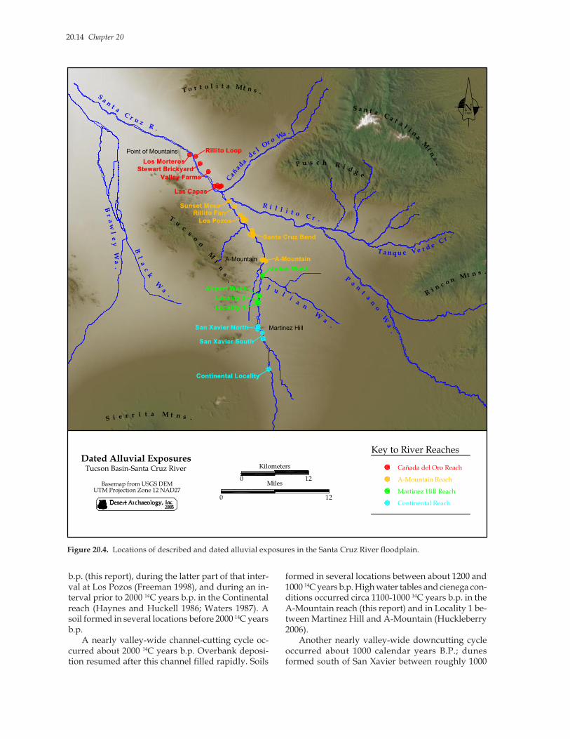
LOCAL PATTERNS
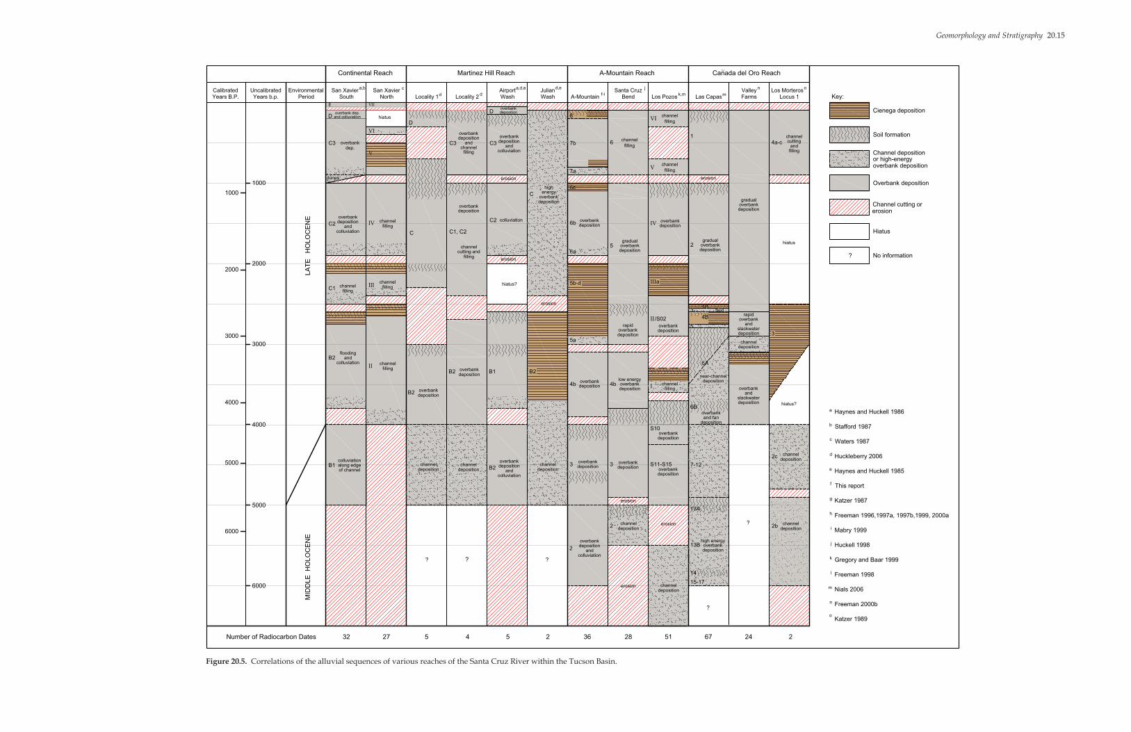
Many of the alluvial processes and resulting depo-sitional units identified in the A-Mountain reach havecorrelates in the 11 other radiocarbon-dated alluvialsequences in the middle Santa Cruz Valley, fromsouth of Martinez Hill to the northern end of theTucson Mountains (Figure 20.4). The estimatedtimespans and associated alluvial processes of thealluvial units identified in those localities are sum-marized in Figure 20.5. For each sequence, the num-ber of radiocarbon dates providing the chronologicalframework is shown below its column. Temporalboundaries of units are shown with solid or dashedlines, according to the level of confidence in the dat-
ing. The localities are grouped by the four reaches ofthe river through the Tucson Basin, as defined byNials (2006), and from left to right, are shown in theirorder from upstream (south) to downstream (north).
One important spatial pattern among the datedalluvial sequences is the presence of middle Holocene(7500-5000 14C years b.p.?) deposits at the East Banksite and most of the downstream localities. These aregenerally coarse or poorly sorted deposits represent-ing in-channel or near-channel deposition duringfloods, high-energy overbank floods, or local slope-wash (colluviation) during rain events. Upstream,erosion and channel widening either predominatedthroughout the middle Holocene, or occurred duringthe late portion of the middle Holocene, removing anysediments deposited earlier during that interval.
Between approximately 5500 and 4000 14C yearsb.p. at A-Mountain and some downstream locations,overbank deposition was interrupted by one or moreintervals of soil formation, representing stable flood-plain surfaces and local channel entrenchment. Inother locations, this interval was characterized byrapid, high-energy overbank and channel depositionand local slopewash.
Following a widespread cycle of downcuttingnear 4000 14C years b.p., rapid overbank depositionbegan in most reaches by 3700 14C years b.p., imply-ing the channel had filled by that time. Cienega con-ditions between approximately 3700 and 2800 b.p.near the mouth of Julian Wash between Martinez Hilland A-Mountain (Locality 4 in Huckleberry 2006)overlapped intervals of cienega conditions near 260014C years b.p. in the upstream Continental Reach(Haynes and Huckell 1986; Waters 1987), betweenabout 3500 and 3300 14C years b.p. at Los Pozos (Nials2006), between about 2800 and 2500 14C years b.p. atLas Capas (Nials 2006), between about 3200 and 310014C years b.p. at Valley Farms (Freeman 2000b), andprior to about 2500 14C years b.p. at Los Morteros,Locus 1 (Katzer 1989). These cienega deposits indi-cate high water tables and unentrenched channelsegments in those locations.
Deposition of overbank and cienega sedimentswas interrupted by intervals of floodplain stabilityand soil formation at Los Pozos between about 3400and 3300 14C years b.p., and in several locations be-tween roughly 3200 and 3000 14C years b.p., and againbetween about 2700 and 2500 14C years b.p. Thesesoils imply local channel entrenchment. About 300014C years b.p., channel cutting occurred at A-Moun-tain and other locations in the A-Mountain reach(Santa Cruz Bend and Los Pozos).
There was valley-wide channel cutting betweenapproximately 2600 and 2500 14C years b.p., followedby channel filling and then overbank deposition. Ahigh water table sustained a cienega at the base ofA-Mountain between roughly 2800 and 2000 14C years
20.14 Chapter 20
b.p. (this report), during the latter part of that inter-val at Los Pozos (Freeman 1998), and during an in-terval prior to 2000 14C years b.p. in the Continentalreach (Haynes and Huckell 1986; Waters 1987). Asoil formed in several locations before 2000 14C yearsb.p.
A nearly valley-wide channel-cutting cycle oc-curred about 2000 14C years b.p. Overbank deposi-tion resumed after this channel filled rapidly. Soils
formed in several locations between about 1200 and1000 14C years b.p. High water tables and cienega con-ditions occurred circa 1100-1000 14C years b.p. in theA-Mountain reach (this report) and in Locality 1 be-tween Martinez Hill and A-Mountain (Huckleberry2006).
Another nearly valley-wide downcutting cycleoccurred about 1000 calendar years B.P.; dunesformed south of San Xavier between roughly 1000
Tu
cs
o
n
Mt
ns
.
S a n t a C a t al i n
a
Mt
ns
.P u s c h R i d g e
Ri n c o n Mt n s .
S i e r r i t a M t n s .
T o r t o l i t a Mt n s .
Br
aw
le
y W
a.
Sa n
t a C r u z R .
Cañ
ad
a d
e l Or o Wa .
R i l l i t o C r .
T a n qu e Ve r d e Cr .
Pa
nt
an
o W
a.
J ul
ia
n W
a.
Bl
ac
k W
a.
Point of Mountains
A-Mountain
Martinez Hill
Santa Cruz Bend
A-Mountain
San Xavier North
Las Capas
Sunset Mesa
Los Pozos
Julian Wash
Airport Wash
Locality 1
Locality 2
San Xavier South
Valley Farms
Stewart BrickyardLos Morteros
Dated Alluvial ExposuresTucson Basin-Santa Cruz River
Basemap from USGS DEMUTM Projection Zone 12 NAD27
0
Kilometers
12Miles
0 12
TrueN
Cañada del Oro Reach
A-Mountain Reach
Martinez Hill Reach
Continental Reach
Key to River Reaches
Rillito Loop
Rillito Fan
Continental Locality
Figure 20.4. Locations of described and dated alluvial exposures in the Santa Cruz River floodplain.
Geomorphology and Stratigraphy 20.15
Figure 20.5. Correlations of the alluvial sequences of various reaches of the Santa Cruz River within the Tucson Basin.
channel
and
Continental Reach
CalibratedYears B.P.
UncalibratedYears b.p. Period
EnvironmentalSouth
San XavierNorth
San XavierLocality 1 Locality 2
AirportWash
JulianWash A-Mountain
Santa CruzBend Los Pozos Las Capas
ValleyFarms
Los MorterosLocus 1
Martinez Hill Reach A-Mountain Reach Canada del Oro Reach
a,b c
d d
a,d,e d,e
f-i
j
k,m m
n o
1000
1000
20002000
3000
3000
4000
4000
5000
5000
6000
6000
dunes
E
D
C3
overbank dep.and colluviation
overbank
C1filling
B2flooding
andcolluviation
B1colluviationalong edgeof channel
LA
TE
H
OLO
CE
NE
MID
DLE
H
OLO
CE
NE
hiatus
V
D
III filling
VI
VII
C
IIchannel
filling
B2 overbankdeposition
channeldeposition
?
32Number of Radiocarbon Dates 27 5 4 5 2 36 28 51 67 24 2
? ?
?
?
Doverbankdeposition
erosion
C3deposition
and
overbank
channelC3 deposition
and
overbank
colluviation
C1, C2
deposition
channel
overbank
cutting and
filling
fillingerosion
C2 colluviation
C energyoverbank
high
deposition
7b
8
7a
6c
6b
6a
5a
erosion
B2 overbankdeposition
B1
hiatus?
channeldeposition B2 deposition
and
overbank
colluviation
channeldeposition
B2
5b-d
depositionoverbank
4b depositionoverbank
3 depositionoverbank
2deposition
and
overbank
colluviation
channeldeposition
channeldeposition
3depositionoverbank
2 erosion
erosion
4bdepositionoverbank
low energy
S11-S15
depositionoverbank
S10
depositionoverbank
I fillingchannel
II
depositionoverbank
/S02
IIIa
depositionoverbank
rapid
6filling
VIfilling
channel
Vfilling
channel
IV
5depositionoverbankgradual
depositionoverbankgradual
2depositionoverbankgradual
1
erosion
4a-c cuttingchannel
filling
hiatus
hiatus?
3
channeldeposition
2b
channeldeposition
2c
andoverbank
rapid
depositionslackwater
depositionchannel
andoverbank
depositionslackwater
5
4A
4B
6A
6B
7-12
13A
13Bdepositionoverbank
high energy
14
15-17
Key:
Cienega deposition
Soil formation
Channel depositionor high-energyoverbank deposition
Overbank deposition
Channel cutting or
Hiatus
Haynes and Huckell 1986
Stafford 1987
Waters 1987
Huckleberry 2006
Haynes and Huckell 1985
This report
Katzer 1987
Freeman 1996,1997a, 1997b,1999, 2000a
Mabry 1999
Huckell 1998
Gregory and Baar 1999
Freeman 1998
Nials 2006
Freeman 2000b
Katzer 1989
a
b
c
d
e
f
g
h
i
j
k
l
m
n
o
C2 depositionand
overbank
colluviation
IVchannel
filling
channelchannel
depositionoverbank
erosion
depositionand fan
overbank
depositionnear-channel
flood
erosion
3
No information?
dep.
20.16 Chapter 20
and 900 calendar years B.P. (Huckell and Haynes1986). Overbank deposition resumed after the chan-nel had filled. Cienega conditions are indicated atA-Mountain circa 800-700 calendar years B.P. (thisreport), and near San Xavier circa 700-500 calendaryears B.P. (Waters 1987).
Within the last 500 years, each reach of the riverhas experienced one or two cycles of channel cut-ting, including the most recent valley-wide channeldowncutting at the end of the nineteenth century.Preceding that event, cienega conditions occurredcirca 200/150-100 calendar years B.P. at A-Mountainand in Huckleberry’s (2006) Locality 1. In severalother locations, soils formed between approximately300 and 100 14C years b.p.
As interpreted here, the middle and late Holocenesequence is divided into several valley-wide alluvialcycles that began with intervals of widespread chan-nel downcutting. These largely correspond with thealluvial cycles defined by Nials (2006; see also Gre-gory and Nials 2005). However, the estimatedtimespans of some cycles have been adjusted withnew data, and Nials’ Cycle 3 (circa 4000-1975 14Cyears b.p.) is subdivided by the almost valley-widedowncutting event near 2500 14C years b.p.
Differences among the reaches in the middleSanta Cruz Valley—such as channel downcutting orsoil formation occurring in some reaches simulta-neous with aggradation in other reaches—is expectedalong an arid-land, discontinuous ephemeral streamsuch as the Santa Cruz River (Bull 1997). Sedimentstorage and transport will also temporally lag betweenupstream and downstream reaches of the main chan-nel, and between tributaries and the main channel(Patton and Schumm 1981). However, there appearto have been a number of valley-wide, near-simul-taneous changes in alluvial processes (see also Wa-ters and Haynes 2001). Major transitions in the olderportions of the sequences, representing long-termchanges in alluvial regimes, occurred between 8000-7500, 5500-5000, and 4000-3700 14C years b.p.
Between three and six cycles of channel cuttingand filling are documented in most reaches over thelast 4,000 years, with widespread but brief episodes(lasting a century or less) of erosion and channel cut-ting occurring near 4000, 2500, 2000, and 1000 14Cyears b.p., and most recently about 110 years ago.The A-Mountain reach became entrenched near 300014C years b.p., and several locations were entrenchedsome 500 years ago. Intervals of floodplain stabilityand soil formation centered near 3700, 3000, 2500,2000, 1000, and 200 14C years b.p. are documented inmultiple reaches, correlating with intervals of chan-nel entrenchment.
Regional Patterns
At a larger scale of comparison, the middle SantaCruz Valley sequence generally fits with a numberof regional trends in Southwestern alluvial se-quences. Figure 20.6 illustrates the age ranges,based on qualitative archaeological and absoluteradiocarbon dating, of selected Holocene valley al-luvial fills in southern Arizona and in other partsof the Greater Southwest. Dark bar segments indi-cate documented timespans of deposits, while thegaps between the bars represent interruptions indeposition and/or erosion. The numbers of associ-ated radiocarbon dates are shown below each ex-ample. For the middle Santa Cruz Valley, the unitdesignations of Haynes and Huckell (1986) are pro-vided. The quality and precision of dating variesconsiderably among sequences; however, somegeneral patterns seem clear.
Throughout the Southwest, deposition of coarsechannel gravels predominated in the late (degla-cial) Wisconsin (14,000-11,000 b.p.). During theearly Holocene, between 11,000 and 8000/7500 14Cyears b.p., mostly fine-grained alluvium was de-posited by overbank floods. A widespread hiatusin deposition and/or erosion starting between 8000and 7500 14C years b.p. was followed by channeldeposition, high-energy overbank deposition, andslopewash beginning at different times between6500 and 5000 14C years b.p. and lasting until about4000-3700 14C years b.p. One or more soils also de-veloped during this interval, indicating sustainedperiods of floodplain stability. A long period ofrapid deposition of fine-grained alluvium and slopewash sediments between about 4000/3700 and 250014C years b.p., followed by steady deposition at aslower rate until about 1000 14C years b.p., is re-corded in many valleys.
Many Southwestern alluvial sequences were in-terrupted by cycles of channel downcutting or wid-ening near approximately 2000 and 1000 14C yearsb.p., including the middle Santa Cruz River(Haynes and Huckell 1986; Waters 1987), themiddle Gila River (Huckleberry 1995; Waters andRavesloot 2000), the Upper San Pedro River(Haynes 1987; Waters and Haynes 2001), andCienega Creek (Eddy and Cooley 1983) in south-ern Arizona. In the same region, Whitewater Drawalso downcut near roughly 1000 14C years b.p. (Wa-ters 1985, 1986b). Since about 1000 14C years b.p.,most Southwestern valleys have experienced oneor two additional cut-and-fill cycles. Many South-western arroyos are currently filling with channeldeposits and colluvium.

Geomorphology and Stratigraphy 20.17
Figure 20.6. Age ranges of Holocene valley alluvial fills in the Greater Southwest, based on radiocarbon and archaeologi-cal dating.
0
SantaCruz
1000
2000
3000
4000
5000
6000
7000
8000
9000
10,000
11,000
B.P.Years
Calibrated
CienegaValley
SanPedro
WhitewaterDraw
RioGrande
CienegaCreek
HopiMesas
ChacoWash
TesuqueValley
1887
D
C3
C2
C1
B2
B1
1900
1-2
upper 4,3,
7
lower 4,5-6,
7
1916
G2b3
G2b2
G2b1
G2a3
G2a2
G2a1
G1
F3
F2
F1
?
?
D
1885
P
H
O
N
M
L
K
J
I
H
G
E
F
1885
Organ III
Organ II
Organ I/Fillmore
? ?
?
?
Isaak'sRanch/Leasburg
?
A
B
C1-3
D1-2
E
1880
Z Naho1860
Post-1880
lowBonito terrace
Y
X upper
W
V lowerTsegi
?
highterrace
TsegiChaco
Gallo
?
?
Jeddito Fajada
(No. of C dates) (+300) (26) (+100) (31) (15)(11) (26) (18) (1)
15,000
14
Haynes and Huckell 1986; Waters 1987; this reporta
Eddy and Cooley 1983b
Haynes 1987c
Sayles and Antevs 1941; Waters 1986ad
Waters and Ravesloot 2000e
Giles 1975g
Hack 1942; Euler et al. 1979; Dean et al. 1985h
Bryan 1954; Hall 1977, 1990i
Miller and Wendorf 1958j
b d f h i jMiddle
Gila
1885
IV
III
e
18,000
(26)
II
I
Middle Middlea gUpper
c
Haury 1957f
b.p.Years
Uncalibrated
1000
2000
3000
4000
5000
6000
7000
8000
9000
11,000
12,000
10,000
0

20.18 Chapter 20
CAUSES AND TIMINGS OF FLOODPLAINAGGRADATION AND EROSION
What were the likely causes of shifts between longintervals of floodplain aggradation and the muchshorter intervals of erosion in the middle Santa CruzValley? Haynes and Huckell (1986) suggested thatclimatic shifts were largely responsible for the mul-tiple late Holocene cut-and-fill cycles, but pointed outthat the fluctuating level of the water table playedan important role in the historic entrenchment of theSanta Cruz floodplain, and probably also influencedthe timings of cutting and filling during prehistory.Huckell (1996, 1998) attributed the documented pat-tern of rapid aggradation of late Holocene alluviumin the Santa Cruz Valley and other valleys of south-eastern Arizona to climatically related changes inrunoff and sediment yield from the slopes of themountains and piedmonts bounding the river valleys.
Waters (1987, 1991), citing the threshold-equilib-rium model of Schumm (1973, 1977), argued that in-trinsic geomorphic thresholds were more importantthan such external factors. Noting that the increasedfrequency of cutting and filling in the Santa Cruzfloodplain during the late Holocene correlates withrapid vertical aggradation (up to 7 m in places),Waters (1987) hypothesized that the gradients of cer-tain channel reaches steepened to the point where acritical threshold of slope was exceeded, increasingtheir susceptibility to incision. Entrenchments of theseunstable reaches of the floodplain could have beentriggered by flooding related to both short-term cli-matic anomalies, including the El Niño effect (see alsoWaters and Haynes 2001), and also longer-durationclimatic states. Aggradation resumed after short in-tervals of floodplain incision.
Freeman (1997b, 2000a) drew attention to the roleof topographic controls on the separate responses ofdifferent reaches of the Santa Cruz River to intrinsicgeomorphic factors. She noted that the near-surfacebedrock at A-Mountain creates a location favorableto sediment storage, and the narrow distance betweenthe mountain on the west and Pleistocene terraceson the east increased the water velocity and sedimentload capacity during floods. Although Freeman(1997b, 2000a) did not discuss it, a similar subsur-face bedrock barrier and lateral constriction occursbetween Martinez Hill and Black Mountain, and hasthe same effects on the San Xavier reaches. Cookeand Reeves (1976) documented that, historically,headcutting initiated at the steep areas of the SantaCruz floodplain immediately downstream from thesesubsurface barriers and the marshy sediment trapsthey created on the upstream sides.
Waters (1987) also raised the possibility that, likehistoric-era farmers in the late nineteenth century,
prehistoric farmers may have unwittingly created lociof entrenchment by constructing irrigation ditches.He has suggested that the nonsynchronous entrench-ment of the San Xavier reaches (during the EarlyRincon phase) and Cienega Creek (during the LateRincon phase) rules out a climatic perturbation asthe cause, and points to the role of human activities(Waters 1991).
Mabry (1999) argued that the lack of synchronicitybetween the Santa Cruz River and Cienega Creek (seeEddy and Cooley 1983), a major tributary, is to beexpected due to the complex response a fluvial sys-tem undergoes to reach a new equilibrium aftercrossing a geomorphic threshold (Schumm 1973,1977). Temporary sediment storage causes a time-lag between deposition in upper and lower parts offluvial systems, and there is also a time-lag betweenerosion in main trunks and in their tributaries asheadward cutting occurs (Patton and Schumm 1981).The result is that a fluvial system is often simulta-neously downcutting in one reach and aggradingin another. This effect is even more pronounced inwatersheds where surface flows and entrenchmentare discontinuous, as was the case for the historicSanta Cruz River (Betancourt and Turner 1990;Cooke and Reeves 1976). It also explains the differ-ences between the alluvial sequences of the differentreaches of the Santa Cruz River considered here.Channel cutting in one or more reaches correlated,at times, with soil formation, colluviation, or over-bank deposition in other reaches, while channel fill-ing sometimes correlated with overbank depositionelsewhere.
More recently, Waters and Haynes (2001) empha-sized the general synchronicity of arroyo-cutting(channel-entrenchment) events in the Santa Cruz andSan Pedro valleys of southern Arizona during thelast 4000 14C years b.p. They noted that four of sixregional arroyo-cutting events coincide with wetperiods documented by other types of paleoenviron-mental records, and inferred that these wet intervalsare related to the El Niño-Southern Oscillation(ENSO) pattern. Similarly, they suggested that theapparent hiatus in arroyo-cutting cycles between theearly and late Holocene is due to a lower intensityand frequency of ENSO events during the middleHolocene (see Fontugne et al. 1999; Keefer et al. 1998;Rodbell et al. 1999). In their broader interpretation,all the synchronous arroyo-cutting events during thelate Holocene are the result of dry-wet climatic cycles(Waters and Haynes 2001). In each case, a precedingperiod of dry conditions lowered water tables andreduced the vegetation covers that protected thedesert valleys from erosion. Flooding subsequentlyresulting from a period of increased precipitation trig-gered arroyo-cutting.
Geomorphology and Stratigraphy 20.19
In the Greater Southwest, a link has been proposedbetween frequent El Niño conditions, increasedtropical and frontal storms (and cutoff low-pressuresystems), and high-magnitude floods capable of en-trenching floodplains. Parker (1995) has suggestedthat periods of channel filling along the Santa CruzRiver correlate with periods dominated by mon-soonal precipitation, as monsoon storms are local-ized, and the floods they cause can transport sedimentsonly short distances. In contrast, the high-magnitude,scouring floods caused by tropical and frontal stormshave the necessary power to connect discontinuouslyentrenched reaches into a single, continuously en-trenched channel (Parker 1995).
In a study of historical weather data and floodmeasurements spanning most of the twentieth cen-tury, Webb and Betancourt (1992) found a correla-tion between El Niño events and high-magnitudefloods along the Santa Cruz River. Studies of paleo-flood deposits across the Southwest have also shownthat, over the last 5000 14C years b.p., the frequencyof high-magnitude floods increased during intervalsof frequent El Niño events (Ely et al. 1993). Deposi-tional evidence of 251 paleofloods along 19 rivers inArizona and southern Utah indicate extreme floodswere most frequent between 4800 and 3600 14C yearsb.p., near 1000 14C years b.p., and after 500 14C yearsb.p., with a peak during the late 1800s and early1900s. Extreme floods were relatively infrequent from3600-2200 and 800-600 14C years b.p.
The hypothesis that cycles of channel downcut-ting in the middle Santa Cruz Valley correlate withintervals of increased frequency of El Niño condi-tions has been developed further by Gregory andNials (2005). They note studies indicating that, in theGreater Southwest, El Niño conditions typically re-sult in reduced monsoonal precipitation (Webb andBetancourt 1992) and increased precipitation from falland winter storms (Andrade and Sellars 1988), result-ing in increased streamflow and probability of floods(Cayan and Webb 1992; Ely et al. 1993). Comparingtrends in atmospheric carbon isotope ratios over thelast 20,000 years with an 8,000-year bristlecone pinetree-ring chronology from southeastern California,they argue that variability in El Niño frequency isrelated to variability in solar activity and present adetailed model of the effects on the Santa Cruz Riverand its floodplain (Gregory and Nials 2005).
Emerging from these studies is a general modelof alluvial regimes, flood frequencies, and downcut-ting cycles being related to shifts between summer-dominant (monsoonal) precipitation, more balancedsummer and winter precipitation, and frequent ElNiño conditions. For example, the predominance ofchannel deposition and localized slopewash deposi-tion in the middle Santa Cruz Valley between about
5000 and 4000 14C years b.p. may have been due toincreased monsoonal rainfall during that interval, asinterpreted from southern Arizona pollen data (Mar-tin 1963; see also Mehringer et al. 1967) and packratmidden data (Van Devender 1987, 1990).
The long interval of rapid overbank depositionand higher water tables, starting between 4000 and3700 14C years b.p., and lasting until about 2500 14Cyears b.p., may represent an interval of more bal-anced summer-winter precipitation and increasedeffective moisture in southern Arizona, as indicatedby higher lake levels (Waters 1989), dune stability(Waters 1986a), and plant taxa in packrat middens(Van Devender 1987, 1990). However, such correla-tions need to be tested with paleoenvironmental datathat allow these different precipitation patterns to bedistinguished. Likewise, the hypothesis that Ho-locene cycles of channel entrenchment in the SantaCruz River watershed correlate with intervals of fre-quent El Niño conditions (Gregory and Nials 2005;Waters and Haynes 2001) needs testing through com-parison of: (1) historical weather data; (2) paleoenvi-ronmental records that can distinguish relatively wetfalls and winters; and (3) the detailed alluvial chro-nology described here.
In summary, these various models all have someempirical support, and the timings of floodplain in-cisions during the Holocene have likely been deter-mined by local geomorphic thresholds, topographiccontrols, and human impacts. However, the long-term trends in floodplain aggradation, channel cut-ting, and other alluvial processes in the Santa Cruzwatershed correlate relatively well with those in otherbasins in the Southwest, and are probably related tolong-term climate shifts (including the frequency ofEl Niño events and the fluctuating strength of themonsoonal pattern) and concomitant changes in veg-etation, surface runoff, water table levels, and sedi-ment supplies.
SITE LOCATIONS, SEDIMENT CONTEXTS,AND PRESERVATION CONDITIONS
Throughout prehistoric and historic times, theSanta Cruz River was the main focus of settlementin the Tucson Basin. Most of the known prehistoricsites in the basin are on Pleistocene terraces overlook-ing the Holocene floodplain and buried in the flood-plain itself. In the A-Mountain reach, the remains ofprehistoric occupations have been found in the flood-plain at depths between 20 cm and 400 cm below thepresent ground surface. They generally correlate withburied soil horizons representing periods of relativestability of the floodplain and, to a lesser extent, withoverbank deposits representing aggradation. Historic
20.20 Chapter 20
remains are generally limited to the upper 50 cm.The identified prehistoric and historic-era canals gen-erally correlate with soil surfaces and cienega clays.
While rapid accumulation of alluvium has pre-served a 4,100-year sequence of cultural remains inthe A-Mountain reach, the alternate wetting and dry-ing of sediments has accelerated oxidation of organicmaterials. This has led to poor preservation of pol-len and uncarbonized plant parts and animal bones,thereby skewing the archaeological record towardartifacts made of unperishable materials and carbon-ized organic remains. It is also very likely that themultiple cycles of channel cutting during the Ho-locene have removed a significant portion of the ar-chaeological record.
The possible presence of middle Holocene depos-its in the A-Mountain reach (at least on the easternside of the present channel) is important because de-posits of such age are very rare throughout the South-west (see Figure 20.4), and because it means thatmiddle Holocene cultural remains could be pre-served in some locations in this reach. If they arefound, remains of this age would be highly signifi-cant because archaeological sites definitely datingbetween 7600 and 4900 14C years b.p. (circa 6400-3700B.C. calibrated) have not yet been found in southernArizona (Mabry 1998b). Any information about cul-tural activities during that interval characterized bygenerally less favorable climate and erosion of thelandscape would fill a prominent gap in currentknowledge of southern Arizona prehistory.
ALLUVIAL PROCESSES AND CULTURALACTIVITIES
The documented intervals of prehistoric occupa-tion in the A-Mountain reach of the Santa Cruz Rivercorrelate with intervals of relatively mesic climate, ahigh water table, perennial soil moisture, and flood-plain stability or aggradation. For humans, this setof conditions meant a reliable water supply, a highconcentration of edible wild plants and game, andthe right conditions for water-table farming, floodfarming, and irrigated farming (Bryan 1941; Huckell1996).
The correlation of canals with soils and cienegaclays in this area suggests the ideal conditions forirrigation included a stable or slowly aggrading unen-trenched floodplain and a high water table. Duringperiods characterized by these conditions, water
could be conveyed by gravity, canals silted up lessrapidly (thus requiring cleaning less frequently), andcanals were blown out by floods less often. In addi-tion to diverting surface flows of the river, canals thatwere dug into cienega surfaces could also intercepthigh water tables, thereby conveying water even inseasons (or longer intervals) when there were no sur-face flows. While the heavy, constantly saturated, andsomewhat saline cienega clays were probably notcultivated, the canals could have directed water toagricultural fields located on the coarser, better-drained sediments on the margins of cienegas.
However, the floodplain in the A-Mountain reachwas probably abandoned temporarily by humangroups whenever the river channel was incising.Channel entrenchment implies a lowered water tableand more difficult access to a drinking supply, a de-crease in wild food resources in the riparian zone, areduced frequency and regularity of overbank floodsnecessary for floodwater farming, and stranding ofcanal intakes for irrigated agriculture. Incision cyclesusually lasted a century or less, according to the dat-ing information from the alluvial fills (Haynes andHuckell 1986). This suggests that, while floodplainentrenchment was a recurrent problem for inhabit-ants of this reach of the valley, conditions becamefavorable again after only a few generations.
Current dating information from archaeologicalcontexts indicates generally continuous human oc-cupation of the A-Mountain reach over the last 4,100years, with interruptions generally being shorter thancan be demonstrated with current dating techniques.The only apparent long-term break in occupationduring the late Holocene was between about 3200and 2600 14C years b.p., an interval approximatelyequivalent to the San Pedro phase (circa 3200-2800calendar years B.P.), for which archaeological re-mains have not yet been documented in this part ofthe Santa Cruz floodplain. However, this gap in thearchaeological record is probably only a samplingproblem, and San Pedro phase cultural remains willlikely be documented by future archaeological inves-tigations in this area of the floodplain, on the olderterraces above the floodplain, or on nearby TumamocHill. The floodplain area immediately upstream ofA-Mountain, where the subsurface barrier of bedrockforces groundwater upward, would have been oneof the last oases in the middle Santa Cruz Valleyduring periods of dry climate. It is therefore likelythat human occupation is more continuous in thislocation than in most other areas of the floodplain.
Ahlstrom, Richard V. N., Heidi Roberts, and GaryHuckleberry
1994 Archaeological and Geomorphological Overviewand Testing Plan for the Rio Nuevo Property,Tucson, Pima County, Arizona. ArchaeologicalReport No. 94-174. SWCA, Inc., Tucson.
Andrade, E. R., and W. D. Sellers 1988 El Niño and its Effect on Precipitation in Ari-
zona and Western New Mexico. Journal of Cli-matology 8:403-410.
Betancourt, Julio L., and Raymond M. Turner 1990 Tucson’s Santa Cruz River and the Arroyo
Legacy. Ms. on file, Desert Archaeology, Inc.,Tucson.
Bryan, Kirk 1941 Pre-Columbian Agriculture in the Southwest
as Conditioned by Periods of Alluviation. An-nals of the Association of American Geographers31:219-242.
1954 The Geology of Chaco Canyon, New Mexico,in Relation to the Life and Remains of thePrehistoric Peoples of Pueblo Bonito. Smith-sonian Miscellaneous Collections 122(7). Wash-ington, D.C.
Bull, William B. 1997 Discontinuous Ephemeral Streams. Geomor-
phology 19:227-276.
Cayan, Daniel R., and Robert H. Webb 1992 El Niño/Southern Oscillation and Stream-
flow in the Western United States. In El Niño:Historical and Paleoclimatic Aspects of the South-ern Oscillation, edited by H. F. Diaz and V.Markgraf, pp. 29-68. Cambridge UniversityPress, Cambridge, England.
Cooke, Ronald U., and Richard W. Reeves 1976 Arroyos and Environmental Change in the Ameri-
can Southwest. Clarendon Press, Oxford.
Dean, Jeffrey S., Robert C. Euler, George J. Gumer-man, Fred Plog, Richard H. Hevly, and ThorN. V. Karlstrom
1985 Human Behavior, Demography, and Paleo-environment on the Colorado Plateaus. Amer-ican Antiquity 50:537-554.
Diehl, Michael W. 1996 Further Archaeological Investigations of the Rio
Nuevo South Property, City of Tucson, Arizona.Technical Report No. 96-5. Center for DesertArchaeology, Tucson.
1997 Archaeological Investigations of the Early Agri-cultural Period Settlement at the Base of A-Moun-tain, Tucson, Arizona. Technical Report No. 96-21. Center for Desert Archaeology, Tucson.
Eddy, Franklin W., and Maurice E. Cooley 1983 Cultural and Environmental History of Cienega
Valley, Southeastern Arizona. AnthropologicalPapers No. 43. University of Arizona Press,Tucson.
Elson, Mark D., and William H. Doelle 1987 Archaeological Assessment of the Mission Road
Extension: Testing at AZ BB:13:6 (ASM). Tech-nical Report No. 87-6. Institute for AmericanResearch, Tucson.
Ely, Lisa L., Yehouda Enzel, Victor R. Baker, andDaniel R. Cayan
1993 A 5000-Year Record of Extreme Floods andClimate Change in the Southwestern UnitedStates. Science 262:410-412.
Euler, R., G. Gumerman, T. Karlstrom, J. Dean, andR. Hevly
1979 The Colorado Plateaus: Cultural Dynamicsand Paleoenvironment. Science 205:1089-1101.
Fontugne, M., P. Usselmann, D. Lavallée, M. Julien,and C. Hatté
1999 El Niño Variability in the Coastal Desert ofSouthern Peru During the Mid-Holocene.Quaternary Research 52:171-179.
Freeman, Andrea K. L. 1996 Geomorphology. In Further Archaeological
Investigations of the Rio Nuevo South Property,City of Tucson, Arizona, by M. W. Diehl, pp.17-26. Technical Report No. 96-5. Center forDesert Archaeology, Tucson.
REFERENCES CITED
20.22 Chapter 20
Freeman, Andrea K. L. 1997a Geomorphology and Stratigraphy of the A-
Mountain Project Area. In Archaeological In-vestigations of the Early Agricultural PeriodSettlement at the Base of A-Mountain, TucsonArizona, edited by M. W. Diehl, pp. 8-21. Tech-nical Report No. 96-21. Center for Desert Ar-chaeology, Tucson.
1997b Middle to Late Holocene Stream Dynamicsof the Santa Cruz River, Tucson, Arizona:Implications for Human Settlement, the Tran-sition to Agriculture, and Archaeological SitePreservation. Unpublished Ph.D. disserta-tion, Department of Anthropology, Univer-sity of Arizona, Tucson.
1999 Geologic Background and Stratigraphy of theProject Area. In Archaeological Investigationsfor the Menlo Park Storm Drain Project: Prehis-toric and Historic Canal Systems at the Base ofA-Mountain, by A. K. L. Freeman, W. H.Doelle, M. D. Elson, and A. C. Diehl, pp. 8-12. Technical Report No. 96-14. Center forDesert Archaeology, Tucson.
2000a Application of High-Resolution AlluvialStratigraphy in Assessing the Hunter-Gath-erer/Agricultural Transition in the SantaCruz River Valley, Southeastern Arizona.Geoarchaeology 15:559-589.
2000b Geomorphology and Canals. In FarmingThrough the Ages: 3400 Years of Agriculture atthe Valley Farms Site in the Northern TucsonBasin, edited by K. D. Wellman, pp. 95-117.Cultural Resource Report No. 98-226. SWCA,Inc., Tucson.
Freeman, Andrea K. L. (editor) 1998 Archaeological Investigations at the Wetlands
Site, AZ AA:12:90 (ASM). Technical Report No.97-5. Center for Desert Archaeology, Tucson.
Giles, Leland H. 1975 Holocene Soils and Soil Geomorphic Rela-
tions in an Arid Region of Southern NewMexico. Quaternary Research 5:321-360.
Gregory, David A., and Sam W. Baar, IV 1999 Stratigraphy, Chronology, and Characteris-
tics of the Natural and Cultural Deposits. InExcavations in the Santa Cruz River Floodplain:The Middle Archaic Component at Los Pozos,edited by D. A. Gregory, pp. 13-32. Anthro-pological Papers No. 20. Center for DesertArchaeology, Tucson.
Gregory, David A., and Fred L. Nials 2005 The Environmental Context of Early Agricul-
tural Period Occupations in the Tucson Ba-sin. In Subsistence and Resource Use Strategiesof Early Agricultural Communities in SouthernArizona, edited by M. W. Diehl, pp. 19-71.Anthropological Papers No. 34. Center forDesert Archaeology, Tucson.
Hack, John T. 1942 The Changing Physical Environment of the Hopi
Indians of Arizona. Papers of the PeabodyMuseum of American Archaeology and Eth-nography 35(1). Harvard University, Cam-bridge, Massachusetts.
Hall, Stephen A. 1977 Late Quaternary Sedimentation and Paleo-
ecologic History of Chaco Canyon, NewMexico. Geological Society of America Bulletin88:1593-1618.
1990 Holocene Landscapes of the San Juan Basin,New Mexico: Geomorphic, Climatic, and Cul-tural Dynamics. In Archaeological Geology ofNorth America, edited by N. P. Lasca and J.Donahue, pp. 323-334. Geological Society ofAmerica, Boulder.
Haury, Emil W. 1957 An Alluvial Site on the San Carlos Indian
Reservation, Arizona. American Antiquity23:2-27.
Haynes, C. Vance, Jr. 1987 Curry Draw, Cochise County, Arizona: A
Late Quaternary Stratigraphic Record ofPleistocene Extinction and Paleo-Indian Ac-tivities. Geological Society of America CentennialField Guide–Cordilleran Section 1987:23-28.
Haynes, C. Vance, Jr., and Bruce B. Huckell 1985 Geological and Archaeological Investigations
along Airport Wash in the Southern Tucson Ba-sin. Technical Report No. 85-4. Institute forAmerican Research, Tucson.
1986 Sedimentary Successions of the Prehistoric SantaCruz River, Tucson, Arizona. Open File ReportNo. 86-15. Arizona Bureau of Geology andMineral Technology, University of Arizona,Tucson.
Hendrickson, Dean A., and W. L. Minckley 1984 Ciénegas—Vanishing Climax Communities
of the American Southwest. Desert Plants6(3):131-175.

Geomorphology and Stratigraphy 20.23
Huckell, Bruce B. 1996 Middle to Late Holocene Stream Behavior
and the Transition to Agriculture in South-eastern Arizona. In Early Formative Adapta-tions in the Southern Southwest, edited by B. J.Roth, pp. 27-36. Monographs in World Ar-chaeology No. 25. Prehistory Press, Madison,Wisconsin.
1998 Alluvial Stratigraphy of the Santa Cruz BendReach. In Archaeological Investigations of EarlyVillage Sites in the Middle Santa Cruz Valley:Analyses and Synthesis, part I, edited by J. B.Mabry, pp. 31-56. Anthropological PapersNo. 19. Center for Desert Archaeology, Tuc-son.
Huckleberry, Gary A. 1995 Archaeological Implications of Late-Holocene
Channel Changes in the Middle Gila River.Geoarchaeology 10:159-182.
2006 Alluvial Chronology for the Martinez Hill-Sentinel Peak Reach of the Santa Cruz Riverin Southwest Tucson, Arizona. In Craft Spe-cialization in the Southern Tucson Basin: Ar-chaeological Excavations at the Julian Wash Site,AZ BB:13:17 (ASM): Part 2. Synthetic Studies(Draft), by H. D. Wallace. AnthropologicalPapers No. 40. Center for Desert Archaeol-ogy, Tucson.
Katzer, Keith L. 1987 Geological Reconnaissance of the Mission
Road Extension. In Archaeological Assessmentof the Mission Road Extension: Testing at AZBB:13:6 (ASM), edited by M. D. Elson and W.H. Doelle, pp. 63-65. Technical Report No. 87-6. Institute for American Research, Tucson.
1989 The Stratigraphy and Geomorphic History ofthe Los Morteros Canals (AZ AA:12:57, Lo-cus 1). In Archaeological Investigations at LosMorteros, AZ AA:12:57, Locus 1, in the North-ern Tucson Basin, by M. Bernard-Shaw, pp. 57-71. Technical Report No. 87-8. Institute forAmerican Research, Tucson.
Keefer, D. K., S. deFrance, M. Moseley, J. Richard-son, D. Satterlee, and A. Day-Lewis
1998 Early Maritime Economy and El Niño Eventsat Quebrada Tacahuay, Peru. Science 281:1833-1835.
Mabry, Jonathan B. 1998a Introduction. In Archaeological Investigations
of Early Village Sites in the Middle Santa CruzValley: Analyses and Synthesis, part I, editedby J. B. Mabry, pp. 1-29. Anthropological Pa-pers No. 19. Center for Desert Archaeology,Tucson.
1998b Paleoindian and Archaic Sites in Arizona. Tech-nical Report No. 97-7. Center for Desert Ar-chaeology, Tucson.
1999 Summary and Interpretations. In PrehistoricUses of a Developing Floodplain: ArchaeologicalInvestigations on the East Bank of the Santa CruzRiver at A-Mountain, by J. B. Mabry, M. W.Lindeman, and H. Wöcherl, pp. 88-98. Tech-nical Report No. 98-10. Desert Archaeology,Inc., Tucson.
Martin, Paul S. 1963 The Last 10,000 Years: A Fossil Pollen Record of
the American Southwest. University of ArizonaPress, Tucson.
McKittrick, Mary Anne 1988 Surficial Geologic Maps of the Tucson Metropoli-
tan Area. Open-file Report No. 88-18. ArizonaGeological Survey, Tucson.
Mehringer, Peter J., Jr., Paul S. Martin, and C. V.Haynes, Jr.
1967 Murray Springs, a Mid-postglacial PollenRecord from Southern Arizona. AmericanJournal of Science 265:786-797.
Miller, J., and F. Wendorf 1958 Alluvial Chronology of the Tesuque Valley,
New Mexico. Journal of Geology 66:177-194.
Nials, Fred L. 2006 Geomorphology and Stratigraphy. In Las
Capas: Early Irrigation and Sedentism in a South-western Floodplain (Draft), edited by J. B.Mabry. Anthropological Papers No. 28. Cen-ter for Desert Archaeology, Tucson.
Parker, John T. C. 1995 Geomorphology and Hydrology of the Santa
Cruz River, Southeastern Arizona. Unpub-lished Ph.D. dissertation, Department of Geo-sciences, University of Arizona, Tucson.
20.24 Chapter 20
Patton, P. C., and S. A. Schumm 1981 Ephemeral Stream Processes: Implications for
Studies of Quaternary Valley Fills. QuaternaryResearch 15:24-43.
Rodbell, D. T., G. O. Seltzer, D. M. Anderson, M. B.Abbott, D. B. Enfield, and J. H. Newman
1999 An ~15,000-Year Record of El Niño-DrivenAlluviation in Southwestern Ecuador. Science283:516-520.
Sayles, E. B., and Ernst Antevs 1941 The Cochise Culture. Medallion Papers No. 29.
Gila Pueblo, Globe, Arizona.
Schumm, Stanley A. 1973 Geomorphic Thresholds and Complex Re-
sponse of Drainage Systems. In Fluvial Geo-morphology, edited by M. Morisawa, pp. 299-310. State University of New York Publica-tions in Geomorphology, Binghamton.
1977 The Fluvial System. John Wiley and Sons, NewYork.
Smith, G. E. P. 1938 The Physiography of Arizona Valleys and the
Occurrence of Groundwater. Technical BulletinNo. 77. College of Agriculture, University ofArizona, Tucson.
Stafford, Thomas W., Jr. 1987 Quaternary Alluvial Stratigraphy Reconnais-
sance of the Santa Cruz River, Tucson, Ari-zona. In The San Xavier Archaeological Project,by M. L. Heuett, S. Miller, J. L. Betancourt, andT. W. Stafford, Jr. Southwest Cultural Series,No. 1, Vol. 1, Section 2C. Cultural and Envi-ronmental Systems, Inc., Tucson.
Van Devender, Thomas R. 1987 Holocene Vegetation and Climate in the
Puerto Blanco Mountains, Southwestern Ari-zona. Quaternary Research 27:51-72.
1990 Late Quaternary Vegetation and Climate of theSonoran Desert, United States and Mexico. InPackrat Middens: The Last 40,000 Years of BioticChange, edited by J. L. Betancourt, T. R. VanDevender, and P. S. Martin, pp. 134-165. Uni-versity of Arizona Press, Tucson.
Waters, Michael R. 1985 Late Quaternary Alluvial Stratigraphy of
Whitewater Draw, Arizona: Implications forRegional Correlation of Fluvial Deposits inthe American Southwest. Geology 13:705-708.
1986a Geoarchaeological Investigations of the Pica-cho Study Area. In Prehistoric Hunter-gather-ers of South Central Arizona: The Picacho Reser-voir Project, edited by F. E. Bayham, D. H.Morris, and M. S. Shackley, pp. 17-35. An-thropological Field Studies No. 13. Office ofCultural Resource Management, Departmentof Anthropology, Arizona State University,Tempe.
1986b The Geoarchaeology of Whitewater Draw, Ari-zona. Anthropological Papers No. 45. Univer-sity of Arizona Press, Tucson.
1987 Holocene Alluvial Geology and Geoarchae-ology of AZ BB:13:14 and the San XavierReach of the Santa Cruz River, Arizona. InThe Archaeology of the San Xavier Bridge Site(AZ BB:13:14), Tucson Basin, Southern Arizona,edited by J. C. Ravesloot, pp. 39-60. Archaeo-logical Series No. 171. Arizona State Museum,University of Arizona, Tucson.
1988 The Impact of Fluvial Processes and Land-scape Evolution on the Archaeological Sitesand Settlement Patterns along the San XavierReach of the Santa Cruz River, Arizona.Geoarchaeology 3:205-219.
1989 Late Quaternary Lacustrine History andPaleoclimatic Significance of Pluvial LakeCochise, Southeastern Arizona. QuaternaryResearch 32:1-11.
1991 The Geoarchaeology of Gullies and Arroyosin Southern Arizona. Journal of Field Archae-ology 18:141-159.
Waters, Michael R., and C. Vance Haynes 2001 Late Quaternary Arroyo Formation and Cli-
mate Change in the American Southwest.Geology 29:399-402.
Waters, Michael R., and John C. Ravesloot 2000 Late Quaternary Geology of the Middle Gila
River, Gila River Indian Reservation, Ari-zona. Quaternary Research 54:49-57.
Webb, Robert H., and Julio L. Betancourt 1992 Climatic Variability and Flood Frequency of the
Santa Cruz River, Pima County, Arizona. Wa-ter-Supply Paper No. 2379. U.S. GeologicalSurvey, Washington, D.C.