geophysical and geological evidence for the benue...
TRANSCRIPT

TJournal of African Earth Sciences, Vol. 2, No.2. pp. 141to 150, 1984Printed in Great Britain
0731-7247/84 $3.00 + 0.00
Pergamon Press Ltd.
Geophysical and geological evidence for the Benue-Chad BasinCretaceous rift valley system and its tectonic implications
C. R. CRATCHLEY
Institute of Geological Sciences, Exhibition Road, South Kensington, London SW7, U.K.
P. LoUIS
Centre Geologique et Geophysique, Universite des Sciences, 34060 Montpellier, France
and
D. E. AJAKAIYE
Department of Physics, Ahmadou Bello University, Zaria. Nigeria
(Received 21 February 1984)
Abstract-Various geological and geophysical studies of the Chad Basin and Benue trough are reviewed. Wecritically examine the geodynamic models previously proposed for the region and finally present our own model.The main points of this model'are as follows: a Precambrian origin for the major anomaly of Haraz, the Benuetrough interpreted as a failed arm of the triple junction created during the opening of the Atlantic, theinterpretation of the Bake-Birao trough as an extension of the Ngaundere-Mbere system rejuvenated in theCretaceous; and a phase of extension in the East Niger contemporaneous with the Benue closing.
INTRODUCTION
THISPAPERis a review and summary of work previouslypresented or published independently by the authors(Cratchley and Jones 1965, Louis 1970, Ajakaiye andBurke 1973, Ajakaiye 1981). These accounts have beenvariously referred to in papers by several authors asevidence in support of their hypotheses regarding themechanisms which might have been associated with thebreakaway of South America from Africa during theCretaceous (Burke et al. 1971, Artsybashev and Kogbe1974,Burke and Dewey 1974, Olade 1975, Wright 1975,1976, Burke 1976, Offodile 1976, etc.). The purpose ofthe present paper is to give a summary of the importantfeatures in our interpretation of the geological work ofothers as well as our own geophysical studies as theyrelate to the rift system of the Benue trough and ChadBasin.
It appears to us that not only have some of thepublished results been over-simplified in some of theproposed hypotheses but also in some cases, the pro-posed hypotheses contain significant omissions or errorssince the most recent results have not been used. Thisapplies particularly to interpretations of the develop-ment of rift valleys through the Chad Basin in support oftriple junction development. This account aims to set onrecord the important geological/geophysical features ofthe region and to assess these as evidence for or againstthe recent hypotheses proposed by others.
OUTLINE OF THE WORK
During the period from 1959 to 1979, a regional
gravity network was established over the Chad Basinand Benue Valley in West and Central Africa. Over themajor part of the basin (Republics of Cameroun, Nigerand Tchad) gravity surveys were carried out by theOffice de la Recherche Scientifique et Technique OutreMer (ORSTOM), Paris. In the southwestern part of thebasin (Nigeria) and the Benue trough, gravity andmagnetic surveys were carried out mainly by the Over-seas Geological Surveys (OGS), London and theGeological Survey of Nigeria, and by various individu-als. Altogether at least 34,000 gravity stations wereestablished over an area of 180 degree squares. Inaddition 13 seismic refraction lines were placed oversignificant gravity anomalies in NE Nigeria and 300 longline electrical resistivity soundings were made across themajor troughs in the basin.
The results of these surveys have been reported indetail by Cratchley (1960), Cratchley and Jones (1965),Louis (1970), Myada (1979), Osazuwa (1978), Adighije(1979), Ajayi (1979), Ajakaiye (1981) etc. This papersummarizes the main results and interpretations in termsof the major structural features of the Chad Basin andBenue trough, and discusses their possible significancein relatiolt to the opening of the South Atlantic Oceanand hypotheses proposed in the literature (Grant 1971,Burke and Dewey 1974, Burke 1976, Wright 1976).
GENERAL GEOLOGY
The Chad Basin occupies a vast area at an altitude ofbetween 200 and 500 m above sea level in central Africa,over most of which the Quaternary Chad formationsmasks older rocks (Fig. 1). Of particular importance to
141
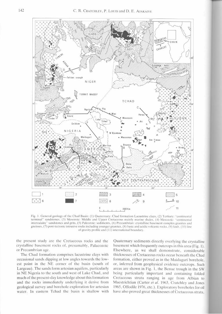
142 C. R. CRATCHLEY,P. LouIs and D. E. AJAKAIYE
/,~!.\}j~~i~~ 4
/y 9
~5~10
300 KmJ
Fig. 1. General geology of the Chad Basin: (1) Quaternary: Chad formation Lacustrine clays. (2) Tertiary: "continentalterminal" sandstones. (3) Mesozoic: Middle and Upper Cretaceous mainly marine shales. (4) Mesozoic: "continentalintercalaire" sandstones and grits. (5) Paleozoic: sediments. (6) Precambrian: crystalline basement complex granites andgneisses. (7) post-tectonic intrusive rocks including younger granites. (8) basic and acidic volcanic rocks. (9) fault. (10) line
of gravity profile and (11) international boundary.
the present study are the Cretaceous rocks and thecrystalline basement rocks of, presumably, Palaeozoicor Precambrian age.
The Chad formation comprises lacustrine clays withoccasional sands dipping at low angles towards the low-est point in the NE corner of the basin (south ofLargeau). The sands form artesian aquifers, particularlyin NE Nigeria to the south and west of Lake Chad, andmuch of the present-day knowledge about this formationand the rocks immediately underlying it derive fromgeological survey and borehole exploration for artesianwater. In eastern Tchad the basin is shallow with
Quaternary sediments directly overlying the crystallinebasement which frequently outcrops in this area (Fig. 1).Elsewhere, as we shall demonstrate, considerablethicknesses of Cretaceous rocks occur beneath the Chadformation, either proved as in the Maiduguri borehole,or, inferred from geophysical evidence outcrops. Suchareas are shown in Fig. 1, the Benue trough in the SWbeing particularly important and containing foldedCretaceous strata ranging in age from Albian toMaestrichtian (Carter et ai. 1963, Cratchley and Jones1965, Offodile 1976, etc.). Exploratory boreholes for oilhave also proved great thicknesses of Cretaceous strata,

Benue-Chad Basin rift vaHey system 143
g'
12'
g'
g' 12'
15' 18' 121'~~~$~~;;~1
[:::::::::j 2
1::::::13\;<>::'14_5
.'>~.~.~.~.~.
15'
12
21'
Fig. 2. Schematic outline of the Bouguer anomaly of the Chad Basin. A-A': line of gravity profile. la,b,c: Benue trough;2a: Doba trough; 2b: Bake-Birao trough; 2c: Bousso trough; 3a: Haraz positive anomaly; 4a: Tenere rift; 4b: Tenere rift;4c: Tefidet rift; Sa: Rig-Rig anomaly; 5b: Termit anomaly; 6a: Maiduguri trough; 6b: Gombe trough; 7: Largeau Basin.
I: <-70 mgals; 2: - 70 to -50 mgals; 3: -50 to -30 mgals; 4: -30 to -10 mgals; 5: >-10 mgals.
Iit
t
particularly in Southern Tchad (Doba trough) and to thenorth and south of Lake Chad.
Both marine and continental facies of Cretaceous ageare found in boreholes located in Maiduguri and areparticularly significant in any discussion concerning rift-ing and possible marine invasion via the Benue troughinto the Chad Basin itself. Continental facies rep-resented by massive sandstone formations (e.g. theBimasandstone of Cenomonian age) are known to occurboth in the Benue trough and in the Niger basin to thewestof the present study area.
Palaeozoic formations exist in the region but theirpresence or absence beneath the Chad formation isunknown.
Where exposed around the edges of the basin and asinliers within it, the crystalline basement comprisesmainly granite and gneiss with smaHer areas of mica
schist. Basalts and minor basic and acidic intrusions,particularly of Tertiary age, are common, especially inTibesti and Cameroun, and to a lesser degree in Air.Minor intrusions and basalts of probable mid-Cretace-ous are known in the Benue trough. The Jurassic"Younger Granite" intrusions of the Jos Plateau and Airare also noteworthy.
Several major tectonic directions are seen in the base-ment, particularly NW-SE fractures in the Air andNNE-SSW fractures in Tibesti.
GRAVITY ANOMALIES
The major features of the Bouguer gravity field areshown in Fig. 2 based primarily on Cratchley (1960),Cratchley and Jones (1965) and Louis (1970).

Fowo
144 C. R. CRATCHLEY,P. LouIs and D. E. AJAKAIYE
A.0"
~. ./_5~~1"-~:~;~~~dAnom'ly
Obr.rved and Regional Bouguer Anomalies 1 and 2
-""
mil K",~I -..:.::U~~ :::: ~ I~k..
Residual Bouguer Anomaly 2 and Model ~ SObo
Bs."
ED100
Ew
,'00
.'000
A'SE
o
1-30
B'o
F'SE
= .10r-;'-20
1-30. -40
i-50m.oo
SP11,.... .~-IOOOI
~ooc!.30oo
D'0'
OOO
j
~ 0
e 800
116002<..
!J..
sketch plan 01 actual line of resistivity soundingsI profile EE')
o'lwow
~ Position of electrical sounding~ Chad Formation I:;:;:;:;:;:;:;::I Continental Interealaire
100 True resistivity in ohm-m~ =~ Unidentified Sediments~====:====~
(
'ha,e,
"..' COIu'nenlal Terminal .k:::::::::::::::d grll5 1++++++4 Crystalline Basement
Borehole BH
SP3 Seismic shotpoinl
E=.====-::=~ Miadle Cretotccous shales or maris
UII.m Unidentified resistant Substratum
I \ Fault or Flexure
Fig. 3. Interpreted sections along Bouguer profiles.
Anomaly I-The Benue trough
The Benue trough has been considered by manyauthors in discussion on the origin of this feature (King1950, Carter .etal. 1963, Burke et al. 1971, Grant 1971,etc.). The present authors consider that the accountgiven by Cratchley and Jones (1965) in interpreting thegeological and gravitational evidence stands as a reason-able explanation of the origin and subsequent develop-ment of the Benue trough.
The characteristic gravity profile across the Cretace-ous trough (profile AA' Fig. 2) shows a marked centralpositive anomaly flanked over the length of the MiddleBenue by two negative anomalies. Interpretation of thisprofile is by a two-dimensional model in which theregional Bouguer anomaly requires crustal thinningbeneath the centre of the trough in excess of that neces-sary for isostatic compensation of topography alone. Ingeneral, the axial positive regional anomaly observedacross the trough could be attributed to a thinning of the
Dsw"
i'-: 301
1!.i

Benue-Chad Basin rift valley system 145
SE
Kwarge Lafia Numan Mayo Belwa
Kaltu,ngo j l j h--LJ ~Assumed Regional
Jada, ," ', '
" Rib,adu, ," ',~ Ganye, ., ,"",I--+-i
o 20Km
NW SEc
_ ~._ Q) .~I Valda Formation
:~ ~:~ g: ::§::: :Benue:Blma.Muri~I;~:,~~:::~::: :Vallev: Yola:BasementI In I 0 1 II III I I II co ;- I n:lE >;1 II :::1111tlAllUViumlsandstone I
I en 'i 1._ (/) I I I ~It' I I I
~ co tt~ Upper Sima sandstone
I Dukul FormationValda Formation
GambaSandstone
Fig. 4. Crustal structure along profile AI-A'I [adapted from Osazuwa et al. (1981). assuming an irregular basement surfaceand basic intrusion into the basement along weak zones].
crust of the order of 2-8 km assuming a density contractof 0.37 x 10³ kg/m3 between the lower crust and themantle in this area. The three attenuation models of Fig.3 show varying amounts of excess mass near surface.There is geological evidence for high density rocks (up to2.65 X 103kg/m3) some of which buried at shallowdepths of 50-500 m in the Albian shales of this centralzone, probably due to intrusion and uplift. Thus, geolog-icallya combination of thinner crust plus density increasein the upper part of the crust, caused by intrusives in thebasement and in the sediments is likely to be the bestinterpretation (Fig. 4). This zone of intrusion and upliftcontinues NE and SW through the major Abakalikianticlinorium (Fig. 1). The location of warm springs andhot brines along the axis of the Benue trough are indica-tions that abnormally hot material can be found beneaththe trough at comparable shallow depths.
The negative anomalies are ascribed to great thicknessof Cretaceous rocks contained within the fault-boundededgesand gravitational interpretation and borehole dateindicate the presence of more than 5500 m thickness.The southern trough probably contains as much as5000m of Cretaceous rocks in some localities.
Based on geological evidence and gravitationalinterpretation the following structural history was pro-posed by Cratchley and Jones (1965). Opening of theBenue trough began prior to marine invasion in the
Albian. The mechanism was rifting under tensionassociated with the separation of South America fromAfrica. Crustal thinning and graben development at thesurface accompanied deposition of perhaps 2000 m ofAlbian marine shales in a narrow Benue seaway. Upliftof the Abakaliki anticlinorium and the central Benuetrough accompanied by intrusion almost certainly occur-red in early Cenomanian and gave rise to the centralpositive anomaly. This was possibly contemporaneouswith uplift of the Adamawa Plateau (Le Marechal andVincent 1970). This is necessary to provide the sourcematerial for the 3000 m of continental and deltaicsandstone deposited in the Middle and Upper Benue inthe Cenomanian (Carter et al. 1963, Offodile 1976) aspalaeocurrent directions suggest a highland source tothe south and southeast of the trough. Further marineinvasion took place in the Turonian and Senonian andduring these periods penetrated through the Chad basinvia the Maiduguri and Gombe troughs (anomalies 6aand 6b) and probably intermittently into the Dobatrough (anomaly 2a) although there is now no directconnection evident into the Doba trough from the Yolaarm (Fig. 1) of the Benue. (This has possibly beenremoved by Tertiary uplift.) Compression of the sedi-ments in the trough into extremely long folds, in theMiddle and Upper Benue generally parallel to the riftboundaries began in the Santonian to the SW of the
NW0
100
en 200
>-';Q 300E0 400c-0:
500
600
0
2
4E=::tl-I>.Wc
34
37
146
c c'
C. R. CRATCHLEY,P. LouIs and D. E. AJAKAIYE
Benue, and reached the Middle Benue by the end of theSenonian. This occurred at the same time that marinedeposition was continuing in the Upper Benue, theGombe and Maiduguri troughs. This fact appears to usto be extremely important as it implies an anticlockwiserotation of the basement block of Northern Nigeriaduring the Senonian. Folding in the Gombe trough didnot occur until the Maestrichtian. The southern Benuetrough was probably closed by Turonian, leaving thenorthern one as the only possible marine link.
As Bouguer anomalies are affected by topographicelevation, certain areas of negative anomaly (e.g. in thevicinity of Adamawa plateau) which appear on Fig. 2 areconsidered to reflect isostatic compensation [see Louis(1970) for map of isostatic anomalies].
Anomaly 2- The Doba and Bake-Birao troughs
The Doba and Bake-Birao troughs (anomaly 2a and2b in Fig. 2) are extremely long (total length is 850 km)sedimentary troughs evidenced by an intense linearnegative gravity anomaly.
The Deba trough, marking the western end of thecombined feature is approximately elliptical (150 kmW-E, 80 km N-S) in shape. Supplementary seismicrefraction measurements and electrical resistivity sound-ings (CPGF 1961, Louis 1970) have indicated sedimentthicknesses in the centre of the Doba trough of at least3500 m. The resistivity interpretation (Fig. 3, profileBB') indicates a varying sequence of sedimentary rocksranging from shales or marls to sandstones and grits.This interpretation suggests the possibility of marine orlacustrine deposits as well as continental sandstones.The presence of about 6000 m of predominantly lacus-trine deposits with some thin marine intercalations hasrecently been revealed in an oil exploration boreholenear Doba (CONOCO, personal communication). Thisis suggestive of only limited marine incursions into theYola arm of the Benue trough, presumably during theCretaceous, although the major accumulation appearsto have been in an intercontinental fault-boundedtrough. At the present time, definite geological evidencefor a connecting trough between Doba and Benue ismissing and the present geological evidence for a connec-tion between the Benue and Doba trough is tenuous.The Bake-Birao trough has a width varying between 40and 70 km over its 700 km extent to the Sudaneseborder. It should be noted that this feature was incor-
rectly marked on the structural map of Africa (UNESCO1968) published prior to Louis (1970), and unfortunatelyused in subsequent papers. For a density contrast of 0.6x 10³ kg/m3 between the sediments and the basementrocks, the simple negative anomaly leads to a depth of3000 m to the basement at Birao.
Separating the Doba and Birao troughs, there is animportant positive Bouguer anomaly which correspondsto a high velocity, higher resistive dyke-like body (Fig. 3,profile BB') and may be related to the faulting andintrusion at Mbere in Cameroun.
Gazel (1956) considers that the age of these faults puts
70
60
50
40
30
20'
10
o10 20 30 4'0 50 60 70 eo k;;;
D- "poO"'f<m'
10
20
Km
Fig, 5, Profile across Hantz anomaly.
them in the lower Precambrian but that they could havebeen rejuvenated in a later geological period giving rifttroughs similar to those of the Benue and Mbere.
To the north of Doba, a gravity anomaly indicates theexistence of a smaller but nonetheless significant troughat Bousso (Fig. 2, anomaly 2c). The Bousso troughextends some 150-200 km in the ESE direction. Itswidth is about 50 km and the sediments in the trough areabout 2000 m thick. From the detailed shape of thegravity anomaly, it can be considered to be a graben.
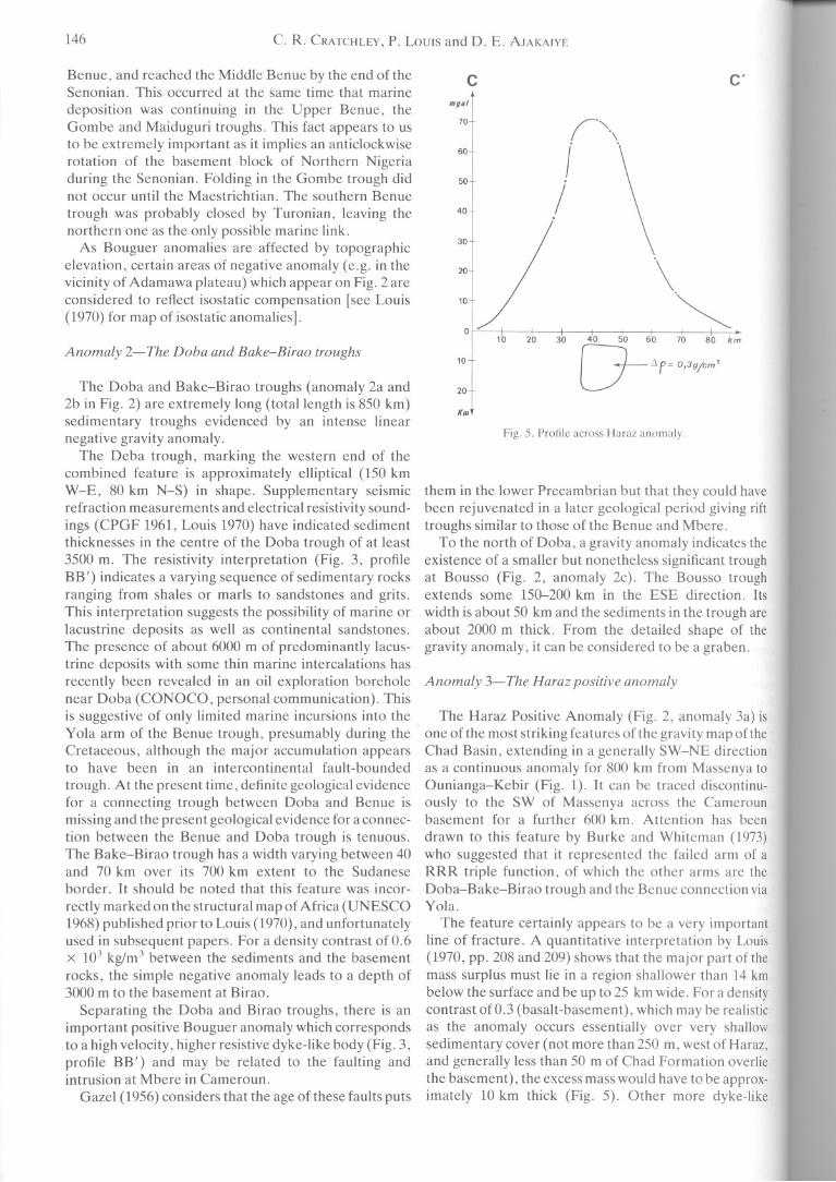
Anomaly 3- The Haraz positive anomaly
The Haraz Positive Anomaly (Fig. 2, anomaly 3a) is. one of the most striking features of the gravity map of the
Chad Basin, extending in a generally SW-NE directionas a continuous anomaly for 800 km from Massenya toOunianga-Kebir (Fig. 1). It can be traced discontinu-ously to the SW of Massenya across the Camerounbasement for a further 600 km. Attention has beendrawn to this feature by Burke and Whiteman (1973)who suggested that it represented the failed arm of aRRR triple function, of which the other arms are theDoba-Bake-Birao trough and the Benue connection viaYola.
The feature certainly appears to be a very importantline of fracture. A quantitative interpretation by Louis(1970, pp. 208 and 209) shows that the major part of themass surplus must lie in a region shallower than 14 kmbelow the surface and be up to 25 km wide. For a densitycontrast of 0.3 (basalt-basement), which may be realisticas the anomaly occurs essentially over very shallowsedimentary cover (not more than 250 m, west of Haraz,and generally less than 50 m of Chad Formation overliethe basement), the excess mass would have to be approx-imately 10 km thick (Fig. 5). Other more dyke-like

Benue-Chad Basin rift valley system
models are possible. The possible origin of this feature isdiscussed later. It is sufficient here to say that there is noother evidence to suggest the age which could be Pre-cambrian by comparison with other areas (Louis 1970);Cretaceous, according to Burke's hypothesis; or possiblyTertiary, associated with the Cameroun and Tibestivolcanic zones (Furon 1960).
Other positive anomalies (Fig. 2, anomaly 3b), notindividually extensive, occur in a well defined but con-tinuous line for a total distance of 900 km from thevicinity of Maiduguri to that of Largeau (Fig. 1).
Anomaly 4-The Tenere rifts
Gravitational and aeromagnetic anomalies, as well asresistivity soundings have all indicated the presence ofthree irregular rifts (Fig. 2, anomalies 4a, b, c), allstriking approximately NW-SE and possibly extendingto the northern and western sides of Lake Chad. Themost extensive rift lies to the east and continues toRig-Rig on Lake Chad; its width varies from 40 to 60 km.The second, near Adrar Madet, is parallel to the first andextends for some 250 km with a width of about 50 km.The third corresponds to the known Tefidet graben.Interpretation of the Bouguer anomaly profiles togetherwith the electrical resistivity sounding results indicatethat the graben are filled with at least 3000 m of sedi-ments (Fig. 3, DO').
Detailed interpretation of resistivity curves (Louis1970,p. 236) has indicated a variable sequence includingprobable Middle Cretaceous slides overlain by 1000m ofpossibly coarser grained rocks.
On strong geological evidence Fauer (1966) placedthe Tefidet trough at the end of the Cretaceous. All theTenere grabens may have a common origin and age,possibly due to the faulting in Tibesti. It is equallypossible that, like similar trending structures in Mali (theGao trough), they originated in the Precambrian andwere rejuvenated during the Cretaceous (Reichelt1967).
Anomaly 5-Negative anomalies north of Lake Chad
The two linear negative anomalies north of LakeChad, shown in Fig. 2 as Rig-Rig (anomaly Sa) andTermit (anomaly 5b) are considered to be extremelyimportant grabens linking the Tenere rifts (anomaly 4)to the Maiduguri troughs (anomaly 6a). Although thepossibility of basement differentiation had to be con-sidered because of the low gradients on these anomalies,it was discarded on the evidence of resistivity soundingsacross the feature. An important aspect of the gravityprofile when compared to the electrical interpretation isevident from profile EE' (Fig. 3) which suggests thatthere is excess mass beneath the centre of the maintrough which may be of a form similar to that found inthe Benue trough but which is here buried beneathQuaternary sediments. Excess mass beneath the Chadsediments is a typical feature of the area around LakeChad and southwards toward Garoua and Adamawa
AES 2:2-£
147
(Fig. 1). It serves to complicate the pattern of gravityanomalies due to sediment in-fill, so that it only becomespossible to suggest an interpretation when other evi-dence from boreholes, seismic determinations or resis-tivity determination can be invoked. A depth of about3000 m of sediment, presumably of Cretaceous age, isindicated by the resistivity interpretations on profile EE'(Fig. 3).
Immediately to the west of Nguigmi (Fig. 1) is anothersmaller negative anomaly, associated with a trough,which has gradients requiring faulting at the edges of theinferred trough (Fig. 3, profile EE'). These buried riftshave quite clear connections, through a rift system, intoNE Nigeria in spite of the lack of data over Lake Chaditself and of the complications of excess mass mentionedabove (Figs 1 and 2).
Anomaly 6---Negative anomalies in northeastern Nigeria
Immediately to the SW of Lake Chad, the Maiduguritrough (Fig. 2, anomaly 6a) is confirmed by seismicrefraction evidence as well as a gravity low as an impor-tant trough, linking anomalies 5 and 1 (Fig. 2). It con-tains about 3000 m of Quaternary and Cretaceous sedi-ments (profile FF', Fig. 3) (Cratchley 1960). In theMaiduguri borehole, to the SW of this profile some1200 m of sediment were penetrated, the lower 600 mbeing marine shales of Santonian-Maestrichtian age(Carter et al. 1963). The basement was not reached. Acomparison between the Bouguer anomalies andthicknesses of Quaternary and Cretaceous sediments,where determined seismically and in boreholes, revealsthe existence of regional positive anomaly of about45 mgal running NNE from near Maiduguri and almostcertainly continuing to the north of Lake Chad. Theexcess mass represented by this anomaly may be similarto that found in the Benue trough, i.e. a combination ofthinning of the crust and intrusion of basic rocks into theunderlying basement and possibly the Cretaceous sedi-ments.
The Maiduguri trough may represent one continuousfracture extending from the Benue trough through LakeChad to the vicinity of Largeau (Figs 1and 6). However,there are numerous other positive anomalies near LakeChad; e.g. at Geidam, which tends to suggest that thestructural history of this area is extremely complex andmay well have been modified in the Tertiary.
The Gombe trough (Fig. 2, anomaly 6b) representsthe continuation of the Cretaceous trough southwest-wards to the Benue trough. Possibly faulted beneathsediment cover (as revealed by aeromagnetic data), theGombe trough is shown by geological and geophysicalevidence to contain at least 2000 m of Cenomanian toMaestrichtian rocks at its northern end. Shales of Maes-trichtian age appear to be equivalent to the Santonian-Maestrichtian shales found in the Maiduguri borehole(Carter et al. 1963). To the west of Gombe, geologicaloutcrops require the presence of at least 600 m of Cre-taceous sediments of which about half are marine shales(Carter et al. 1963) while gravitational and magnetic

148 C. R. CRATCHLEY,P. LOUISand D. E. AJAKAIYE
IS'
12'
+
+
+
+++ 1 ,.,.- 4== a
; 5::: b
Erdis basin ~_paleozoic
+
+
+
+18'+ +
+
Fig. 6. Generalized interpretation of geophysical results in the Chad Basin. I-Basement outcrop; 2-zone of probableintrusion; 3-Cretaceous marine transgression; 4-fault; 5a-basement surface> 1000 m from several geophysical
techniques or from borehole; 5b--basement surface> 1000m from gravimetric survey alone.
evidence suggests the presence of at least 3000 m ofCretaceous rocks. Southwards, the Cretaceous rocksare at least 2000 m thick towards the Upper Benue. Tothe south of Gombe there is geological and gravitationalevidence for at least 5000 m of sediments (Carter et al.1963, Cratchley and Jones 1965, Ajakaiye 1981).
Anomaly 7-Largeau negative anomaly
The large (40 mgal) elliptical negative anomaly whichoccurs in the northeastern section of the Chad Basin hasno obvious connection with other rift anomalies in theBasin. It is quite large, extending to more than 100 kmN-S and about 250 km E-W (Fig. 2). Interpretation, interms of low-density rocks in the basement is possiblebut unlikely when the maximum variations of 20 mgal,observed along traverses across the basement of theOuaddai Massif to the east, are considered. It seemsquite likely that a sedimentary basin several thousandmetres deep may exist here. There is no geological orother geophysical evidence to substantiate this or indi-
cate the possibility of a connection in a SW directionthrough other less well-defined negative anomalies (Fig.2) to the trough on the north side of Lake Chad.
SUMMARY OF EVIDENCE
See Fig. 6. The combined geological and geophysicalinterpretation of data gives strong evidence for a com-plex series of Cretaceous grabens extending into thecentre of the Chad Basin from the SW (Benue) and theNW (Tenere) and bounding its southern edge in themajor Doba-Bake-Birao system. In general, negativegravity anomalies are asociated with these features, butcomplications arise in the Benue trough and aroundLake Chad because of the presence of, probably,igneous intrusions and crustal thinning within andbeneath the grabens. These give rise to a series ofpositive gravity features extending in a NE directionfrom the Benue to the vicinity of Largeau in the NEChad Basin. A notable positive anomaly (Haraz, Mas-
Benue-Chad Basin rift valley system
senya), largely parallel to this direction, is continuousover 800 km of shallow basement and appears to be ofPrecambrian origin. Some important details are:
(1) Benue trough-associated with the separation ofSouth America and Africa, occurred in Albian time andallowed marine invasion at least as far as Yola (the mainarm of the northern section of the Benue trough) in NENigeria. Regression in the Cenomian followed uplift,igneous intrusioin and deposition of Continental Bimasandstone. Renewed invasion in late Cenomanian-Turonian time penetrated to the north, towardsMaiduguri, to the Chad Basin (marine shales encoun-tered in the Maiduguri borehole). Folding in the Benuetrough started during the Santonian while marine de-position was still taking place to the NE.
(2) Doba-Bake-Birao trough-this longer linearfeature is infilled with 600 m of presumed Cretaceoussediments. Borehole evidence in the Doba trough indi-cates essentially lacustrine sediments. Only smallamounts of marine sediments were found, consistentwith the possible hypothesis that a connecting riftbetween Yola and Pala was closed (uplift in lateCenomanian?). The extensive eastward continuation-the Bake-Birao trough, may be associated with transientfaulting (see proposed model below).
(3) Tenere troughs-the topographical, geologicaland gravitational expressions clearly indicate grabenstructures infilled with sediments. Geological evidencein the Telfidet trough indicates Coniacian-Santonianage for the sediments (Faure 1968), i.e. when foldingwas taking place in the lower Benue. Some basic intru-sions occur.
(4) Haraz positive anomaly-this major linear anom-aly is interpreted as a basic intrusion into the basementbeneath shallow sediment cover. The lack of topographi-cal variation on the basement surface, and of evidencefor faulting suggests a Precambrian feature within thepeneplained basement, possibly a large intrusive dyke,although it appears to be non-magnetic (Louis 1970).
DISCUSSION OF REGIONAL TECTONICS
Grant (1971) proposed that the Niger delta formedthe site of a triple junction of the RRF type, the Benuetrough being one of the tensile R arms which partiallyclosed again after the complete separation of SouthAmerica from Africa. This opening followed by "re-bound" due to strain accumulation in the African plate,neatly accounts for the Albian marine invasion followedby compressive folding of the accumulated sediments inthe Santonian and later.
Burke et al. (1971) suggested a triple junction of theRRR type based on gravity data which indicate oceanictype crust beneath the Niger delta. A Santonian orogenyinvolving a Benue subduction zone was also proposed-a hypothesis repeated in Burke and Dewey (1974).These two authors (Burke and Dewey 1973) also pro-posed that early extensional phases of rifting werecaused by plume generated triple junctions, citing Louis
149
(1970); Cratchley and Jones (1965) as gravitational evi-dence for the existence of such junctions at Niger Delta,Chum and Poli (Fig. 6). This interpretation relies on thehypothesis that the Haraz positive anomaly represent8an axial rift dyke of Cretaceous age. However, theevidence for both these hypotheses (Benue subductionzone and Cretaceous triple junction associated with theHaraz anomaly) is extremely tenuous (Louis 1978); theHaraz anomaly is quite unlike the other grabenanomalies and its geological associations are also quitedifferent. However Burke et al. (1971) also suggestedrelative movement within the African plate due to differ-ences in spreading rate and direction between the sectionof the mid-Atlantic ridge opposite the bulge of Africaand that south of the Gulf of Guinea. We support thisconcept as it can explain some of the features of theDoba trough system, and the possible link betweenthese and transform faults via the Ngaundere fault.
Burke (1976) proposed that the Cretaceous rift systembeneath the Quaternary sediments of the Chad Basinhelped to localize this major basin, an idea with whichwe agree. Unfortunately, he again associated the Harazanomaly with a Cretaceous axial rift dyke.
Wright (1976) compared oceanic fracture zone align-ments identified by Francheteau and Le Pichon (1972)with mapped continental fracture systems. The evidencefor continuity in these structures is striking, particularlyfor the Romanche and Chain transcurrent fractures, andthe mapped faults show dextral movements of 10 and30 km. There is also tentative evidence in this paper forthe possible continuation of the Charcot faults, andperhaps other mid-Atlantic transform faults furthersouth of Charcot (Fig. 1), into the African continent topossibly as far as the Mbere-Ngaundere fault system.
Benkhelil (1982) has presented a hypothesis linkingthe Romanche, Chain and Charcot faults directly intothe Benue trough in order to postulate a "pull apartbasin" model for sedimentation in the Benue. We findthis model unconvincing as there is presently lack ofevidence for the cross-faults that are required to bring allthree major transcurrent fractures within the confines ofthe Benue, and indeed, this model is not consistent withthe clear evidence in Wright (1976). It is also difficult tovisualize how marine invasion could have taken placeunder this hypothesis.
In conclusion, we propose a chronological model forthe evolution of this area:
(1) Precambrian:Features in the basement; a particular example of
which is the major anomaly of Haraz. This anomalycould represent the boundary of a continental plateinside the Precambrian but certainly before the Pan-African.
(2) Cretaceous:(a) The history begins by the opening of the Atlantic
with a triple junction RRF (in agreement with Grant1971): a small extension in the Benue trough gives afailed arm; the transform faults (arm F) Romanche andChain fractures zones, are controlled by pre-existinglines of weakness in adjacent continental crust (Nigeria

150
Ajakaiye, D. E. 1981. Geophysical investigations in the Benuetrough-a review. Earth Evolution Sciences 2,110-125.
Ajakaiye, D. E. and Burke, K. 1973. Bouguer gravity map of Nigeria.Tectonophysics 16,103-115.
Ajayi, C. O. and Ajakaiye, D. E. 1981. The origin and peculiarities ofthe Nigerian Benue trough-another look from recent gravity dataobtained from the Middle Benue. Tectonophysics 80, 285-303.
Artsybashev, V. A. and Kogbe, C. A. 1974. Crustal structure of theBenue valley area, Nigeria. Geol. Rundsch. 64,324-329.
Benkhelil, J. 1982. Benue Trough and Benue Chain. Geol. Mag. 119(2),158-168.
Burke, K. 1976. The Chad Basin: an active intra-continental basin.Tectonophysics 36,197-206.
Burke, K. and Dewey, J. F. 1973. Plume-generated triple junctions:key indicators in applying plate tectonics to old rocks. J. Geol. 81,406-433.
Burke, K. and Dewey, J. F. 1974. Two plates in Africa during theCretaceous. Nature, Lond. 249,313-315.
Burke, K. and Whiteman, A. J. 1973. In: Implications of ContinentalDrift to the Earth Sciences (Edited by D. H. Tarling and S. K.Runcom), pp. 735-755.
Burke, K., Dessauvagie, T. E. and Whiteman, A. 1971. Opening ofthe Gulf of Guinea and geological history of the Benue depressionand Niger Delta. Nature, Phys. Sci. 233,51-55.
Carte tectonique intern. de l'Afrique, UNESCO, 1968.Carter, J. D., Barber, W., Tait, E. A. and Jones, G. P. 1963. The
geology of parts of Adamawa, Bauchi and Bornu Provinces innorth-eastern Nigeria. Bull. Geol. Surv. Nigeria No. 30.
Cratchley, C. R. 1960. Geophysical survey of the south-western partof the Chad Basin. Unpubl. paper presented at C.C.T.A. Confer-ence on "Geology", Kaduna, N. Nigeria, February 1960.
Cratchley, C. R. and Jones, G. P. 1965. An interpretation of theGeology and gravity anomalies ofthe Benue Valley, Nigeria. Overs.Geol. Surv. Geophys. Paper, No. 1.
Faure, H. 1966. Reconnaissance geologique des formations sedimen-taires post-paleozoique du Niger oriental. Mem. BRGM, No. 47,Paris.
Francheteau, J. and Le Pichon 1972. Marginal fracture zones asstructural framework of continental margins in South Atlanticocean.J.geophys. Res. 56,991-1007.
Furon, R. 1960. Geologie de I'Afrique, deuxieme edition. Payot,Paris.
Gazel, J. 1956. Geologie du Cameroun. Atlas du Cameroun.Yaounde,IRCAM.
Grant, N. K. 1971. South Atlantic, Benue trough and Gulf of GuineaCretaceous triple junction. Bull. geol. Soc. Am. 82,2295-2298.
King, L. 1950. Speculations upon the outline and the mode of disrup-tion of Gondwanaland. Geol. Mag. 87,353-359.
Le Marechal, A. and Vincent, P. M. 1970. Le fosse cretace duSud-Adamaouia, Cameroun. In: African Geology (Edited by T. F.J. Dessauvagie and A. J. Whiteman), pp. 229-249. Ibadan Univer-sity Press, Ibadan.
Louis, P. 1970. Contribution geophysique a la connaissancegeologique du Bassin du Lac Tchad. Mem. ORSTOM, No. 42,Paris.
Louis, P. 1978. Gravimetrie et geologie en Afrique occidentale etcentrale. Mem. BRGM, No. 91, pp. 53-61.
MacCurry, P. 1971. Pan African orogeny in northern Nigeria. Bull.geol. Soc. Am. 82,3251-3262.
Myada, E. E. 1979. Mafa-Dikwa geophysical anomalies and theirinterpretation. Ph.D. Thesis. Ahmadu Bello University, Zaria.
Offodile, M. E. 1976. The geology of the Middle Benue, Nigeria,Special Vol. 4. Palaeontological Institution of the University ofUppsala, Sweden.
Olade, M. A. 1975. Evolution of Nigeria's Benue trough: a tectonicmodel. Geol. Mag. 112,575-583.
Osazuwa, I. B., Ajakaiye, D. E. and Verheiien, P. J. T. 1981. Analysisof the structure of part of the upper Benue rift valley on the basis ofnew geophysical data. Earth Evolution Sciences 2, 126-135.
Reichelt, R. 1967. La fosse de Gao. Symposium on African Geol.,Vol. 4, Sheffield.
Wright, J. B. 1975. Origins of the Benue trough-a critical review. In:Geology of Nigeria (Edited by C. A. Rogbe), pp. 309-317.Elizabethan Press, Lagos.
Wright, J. B. 1976. Fracture systems in Nigeria and initiation offracture zones in the South Atlantic. Tectonophysics 34,43-47.
C. R. CRATCHLEY,P. LoUIS and D. E. AJAKAIYE
for Romanche and Chain, Ngaundere fault system forthe Charcot fracture zone) (Wright 1976). These pre-existing lines of weakness were probably establishedduring the Pan-African orogeny but these faults maywell represent lineaments of much greater age (Mac-Curry 1971). During the opening of the South Atlantic,these transform faults were active and resulted in arejuvenation of the fault system in the continent. Inparticular, the Ngaundere fault system shows a patternof transcurrent movement whose extension into thecontinent may be represented by the Bake-Benuetrough.
Another interpretation is possible: when consideredas a unit, the Doba and Bake-Birao troughs are alignedin a direction different from that of the Bake-Birao
trough alone. This alignment corresponds to a majorlineament through Africa, running from the Gulf ofGuiinea coast to the coast of the Gulf of Aden. Thislineament could be of Precambrian origin which hasbeen reactivated during the separation of Africa andSouth America (Louis 1970).
(b) Further marine invasion took place in the Benuetrough (Turonian and Senonian for the Middle Benue)and during these periods extended to the Chad Basinand probably from time to time into the Doba trough.Compression of the sediments (end of Senonian in theMiddle Benue) is an indication of the closure that occur-red in the Benue trough during this period. During thistime, the Tenere troughs appeared, while the Tibestiexhibited the first occurrences of fracturation and theDjado was subjected to a brittle tectonic. We must admitthat during a short period, an extension phase in the Eastof Niger is contemporaneous with the Benue closing.We suggest that stresses which generated these eventscame from the "collision" of European and Africanplates in the North. In order to explain the gravityanomalies in the Benue trough and also in the centre ofthe Chad Basin (near the lake) we must assume a fairlyhigh density basement with a possible crustal thinning.Such phenomena related to the formation of grabenscould explain the subsequent importance of sedimenta-tion in the basin (Burke 1976).
(3) Tertiary:(a) Uplift and volcanism appear in the Cameroun and
in the Tibesti. The uplift could possibly have obliteratedtraces of the link between the Yola arm of the Benue intothe Doba trough.
(b) Further sedimentation continues in the Basin.More geophysical and geological data is still required
for a better understanding of the tectonics of the ChadBasin. In particular, the results of seismic reflectionprofiling of the deep crust, deep drilling and geochronol-ogy of the basement around the basin would be veryuseful for this purpose.
REFERENCES
Adighije, C. 1979. Gravity field of Benue trough, Nigeria. Nature,Lond. 282, 199-201.