geospatial readiness analysis - technology · bottom line upfront geospatial readiness will fuse...
TRANSCRIPT

GEOSPATIAL READINESS ANALYSIS
CONCEPT FOR OSD PERSONNEL AND READINESS

Purpose
ACCOMPLISHING THE IMPOSSIBLE
Develop and discuss a concept for geospatial readiness analysis that incorporates: • Geospatial depiction of plans and capabilities • Geospatial representation of intelligence, POL-MIL and other data that can
impact readiness assessments • Linkage of all key command and control, plans, operations, and readiness systems
and data
The attached concept is based upon previous conversations with the DIO and Thermopylae’s understanding of the current status of DRRS implementation and integration with other systems. Once the DIO agrees with the concept and it is validated with OSD(P&R), Thermopylae recommends developing a whitepaper on integrated geospatial readiness and then to seek funding to implement the concept on a pilot basis with on GCC.

Bottom Line Upfront
Geospatial readiness will fuse data from multiple systems into a comprehensive approach to readiness assessments, planning and resource allocation. The configurable geospatial dashboard will allow decision makers to rapidly gain shared situational awareness and make informed decisions. The capabilities added to this approach to DRRS will help OSD to meet Congressionally mandated goals and provide greater incentives for users to fully embrace DRRS and improve its effectiveness. The approach discussed in this presentation uses proven technology that is in use in USSOUTHCOM and elsewhere. It will employ data currently available and fuse it together to show a comprehensive readiness picture and how U.S. forces are postured to respond to current and emerging situations. This approach will significantly streamline design and implementation and provide rapid value to OSD, the Joint Staff, and the Combatant Commands.
ACCOMPLISHING THE IMPOSSIBLE

Discussion Outline
• Situation/need
• Concept overview
• OV-1 Draft
• Design notes
• SOUTHCOM’s 3D UDOP—a potential starting point
• Way ahead
ACCOMPLISHING THE IMPOSSIBLE

SITUATION
ACCOMPLISHING THE IMPOSSIBLE
Is there a need for Geospatial Readiness?

Defense Readiness Reporting System (DRRS) Policy
ACCOMPLISHING THE IMPOSSIBLE
4.1. The DRRS shall provide the means to manage and report the readiness of the Department of Defense and its subordinate Components to execute the National Military Strategy as assigned by the Secretary of Defense in the Defense Planning Guidance, Contingency Planning Guidance, Theater Security Cooperation Guidance, and the Unified Command Plan. All DoD Components will align their readiness reporting processes in accordance with this Directive. 4.2. The DRRS shall build upon the processes and readiness assessment tools used in the Department of Defense to establish a capabilities-based, adaptive, near real-time readiness reporting system. All DoD Components will use the DDRS to identify critical readiness deficiencies, develop strategies for rectifying these deficiencies, and ensure they are addressed in program/budget planning and other DoD management systems.
DODI NUMBER 7730.65 June 3, 2002 Certified Current as of April 23, 2007

Policy (continued)
ACCOMPLISHING THE IMPOSSIBLE
4.3. The DRRS is supported by two DoD readiness management processes. These are the Senior Readiness Oversight Council (SROC) and the Joint Quarterly Readiness Review (JQRR). 4.4. The DoD Components shall develop mission essential tasks or similar indicators for all assigned missions, and use information technology to collect near real-time data on the readiness of military forces and support organizations to perform these missions. 4.5. The Department shall also develop and employ modern readiness assessment tools, software, and models to aid in readiness reporting and assessment. The DRRS will continue to ensure that Commanders' assessments and military judgments are included in the reporting system.

Key Issues
• The policy statement clearly establishes DRRS as – The primary readiness system – A key element of Adaptive Planning and Execution – A key part of the resourcing system and the main way
components will report and support resource requirements/issues
• However: – Does the Defense Readiness Reporting System (DRRS) provide
an accurate assessment of readiness? – Is DRRS properly implemented across the services and
combatant commands? – Is DRRS integrated in to the Adaptive Planning and Execution
(APEX) architecture and construct
ACCOMPLISHING THE IMPOSSIBLE

Key Factors that Impact Readiness
• Plan requirements – Mission and key tasks
– Capability requirements
– Assumptions
• Capability readiness – Unit readiness
– Deployment times
• Situational requirements – Changes in the POL-MIL situation
– Changes in the intelligence estimate [JIPOE (Joint Intelligence Preparation of the Operational Environment)]
ACCOMPLISHING THE IMPOSSIBLE
How do situational changes impact plan assumptions?

Comprehensive Readiness in DRRS
ACCOMPLISHING THE IMPOSSIBLE
DRRS does not, by itself, capture all of these dynamics unless the readiness assessors perform these tasks offline. • Combatant Commands assess plan readiness based upon Mission Essential Tasks
(MET) • METs should be tied to mission essential tasks and key tasks • MET roll up to the overall plan readiness
• Service Components assess based upon METL tasks • Unit level up to METL tasks for a Plan • Unit level readiness may or may not be directly linked to plan readiness
depending upon plan level and service component integration into DRRS • Commanders may subjectively change readiness assessments based on
judgment, situational changes and other variables, but there is no standard approach
DRRS may not properly capture all of the facets of plan readiness and may provide a misleading picture of plan readiness

DRRS Implementation
• DRRS-S is not seamlessly integrated with all service component DRRS implementations
• Some services have not fully transitioned from legacy readiness systems to DRRS
• Some combatant commands have not fully implemented DRRS-S – Hence the need for “Fast Start” programs at the
combatant commands
• Implementation and usage is not standardized across the services and combatant commands
ACCOMPLISHING THE IMPOSSIBLE

DRRS and APEX
• “Adaptive Planning and Execution (APEX) is a system of joint policies, processes, procedures, and reporting structures, supported by communications and information technology that is used by the Joint Planning and Execution Community to monitor, plan, and execute mobilization, deployment, employment, sustainment, redeployment, and demobilization activities associated with joint operations. At full maturity, the APEX system will be a collection of capabilities that provide collaborative planning that facilitates the rapid development and maintenance of plans and, when necessary, the dynamic transition to execution. The APEX system will address and provide combatant commands, service/functional components, combat support agencies (CSA) and the Joint Staff with an aligned end-to-end process, integrated with multi-national partners and US government departments and agencies, as required, facilitated by trained personnel and technology to support planning and execution.” DISA Website (http://www.disa.mil/news/pressresources/factsheets/apex.html)
• “Although the global force management (GFM) business processes are intertwined with adaptive planning and execution (APEX) and readiness, there has been little coordination among these communities towards finding materiel solutions that meet the informational requirements needed to support all three communities. Instead, the adaptive planning and readiness efforts were driven primarily by the development of materiel solutions for their communities and not based on operational requirements3. This has resulted in interoperability problems as these systems cannot exchange information.” Rosamaria S Morales (MITRE, “Modeling Composable Data Schemas for Data Visibility for Adaptive Planning and Force Sourcing Processes “, (2009)
• Readiness assessments should be a key facet of APEX in order to effectively and efficiently allocate and apportion forces
ACCOMPLISHING THE IMPOSSIBLE
While there are discussions of using DRRS to inform and guide APEX, there are little or no formal linkages between the two programs

Situational Assessment
• DRRS is only achieving a portion of its potential as noted by the GAO in 2009 audit
• While there have been improvements since then, readiness is still potentially mis-reported and not effectively integrated into planning and force allocation
• DRRS is now being used to support IPL and other resource systems, but the linkages could be tighter
• DRRS-S may not be fully integrated with the service models
ACCOMPLISHING THE IMPOSSIBLE

CONCEPT OVERVIEW
ACCOMPLISHING THE IMPOSSIBLE
How would it work?
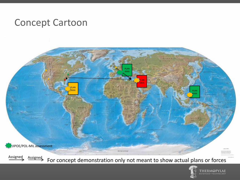
Concept Cartoon
PLAN XXXX
PLAN XXXX
PLAN XXXX
PLAN XXXX
Assigned Assigned For concept demonstration only not meant to show actual plans or forces
JIPOE/POL-MIL assessment

Fully Interactive GIS Display
• Click on JIPOE/POL-MIL icons to drill down into the assessments
• Click on Plan icons to drill down in the plans to include: – MET assessments – Assumptions assessments (have conditions in the AO impacted
the assumptions) – Critical resource shortfalls with linkages to the Integrated
Priority List (IPL) and POM issues – Steady state engagement issues
• Click on force icons to drill on readiness • Click on force-plan linkages to get estimated deployment
times
ACCOMPLISHING THE IMPOSSIBLE

Integrated Systems
• DRRS
• JOPES
• Global Force Management
• GCCS (various versions)
• GCC JIPOE/intelligence products
• GCC POL-MIL products
• IPL
• APEX systems
ACCOMPLISHING THE IMPOSSIBLE

What does this Solve?
• Clearly integrates the JIPOE/POL-MIL assessments with Plan readiness
• Clearly displays the geographic hotspots whether there are forces allocated to plans associated with the hotspots – Shows potentially over allocated forces
– Shows plans in potentially critical areas with little or no allocated forces
– Shows plans that may need to be reviewed quickly for force allocation, assumptions review in preparation for potential execution
• Provides a readiness COP to facilitate APEX and resource allocation decisions
ACCOMPLISHING THE IMPOSSIBLE

OV-1 DRAFT
ACCOMPLISHING THE IMPOSSIBLE
Assumptions
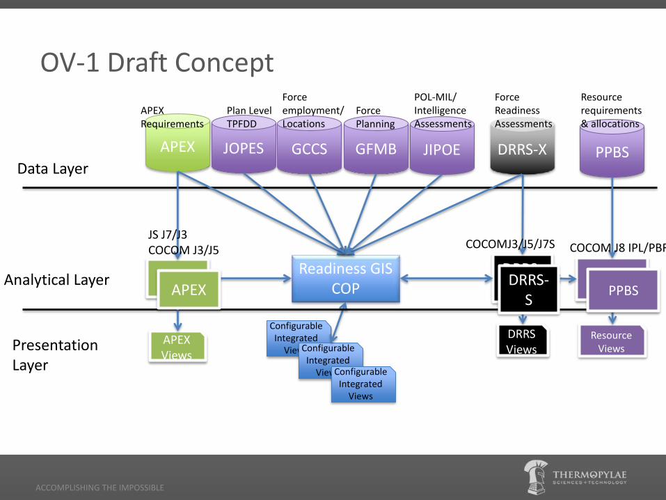
OV-1 Draft Concept
ACCOMPLISHING THE IMPOSSIBLE
Readiness GIS COP
Configurable Integrated
Views Configurable Integrated
Views
DRRS-S
DRRS Views Presentation
Layer
Analytical Layer APEX
APEX Views
PPBS
Resource Views
DRRS-X PPBS APEX
Data Layer JOPES GCCS GFMB JIPOE
Configurable Integrated
Views
Plan Level TPFDD
Force employment/ Locations
Force Planning
POL-MIL/ Intelligence Assessments
Force Readiness Assessments
Resource requirements & allocations
APEX Requirements
COCOMJ3/J5/J7S
DRRS-S
COCOM J8 IPL/PBR JS J7/J3 COCOM J3/J5
PPBS APEX

OV-1 Notes
• Bring in the data from COCOM’s, JS, and other agencies into a holistic view that shows the balance between risk and readiness
• JIPOE data that incorporates all source information, to include POL-MIL data is key to the risk assessment. This is potentially the data that is the most dynamic
• Risk assessments inform readiness assessments and resource allocation decisions in order to plans and operations with the highest impact on national security are properly resourced
• Readiness decisions also inform APEX decisions for contingency operations
ACCOMPLISHING THE IMPOSSIBLE

Risk Assessment Factors
• Changes in Force Posture
– Unit positioning
– Force readiness
– Loss or degradation of basing and facilities, overflight, logistics support
• Change in relationship with key partners
• Increase in crisis potential
ACCOMPLISHING THE IMPOSSIBLE
GCCS
GFMB, JIPOE
DRRS-X
JIPOE
JIPOE, APEX

Risk Mitigation Factors
• Strengthen Force Posture
– Proactively relocate forces
– Add/enhance existing facilities
• Add capabilities such as IPL items
• Strengthen partnerships
– Exercises
– Capability building programs
• Review planning assumptions
ACCOMPLISHING THE IMPOSSIBLE
APEX, GCCS, JOPES
PPBS
PPBS
GFMB, PPBS

DESIGN NOTES
How do we build it?
ACCOMPLISHING THE IMPOSSIBLE

Strategic Balancing
ACCOMPLISHING THE IMPOSSIBLE
Risk Readiness GFMB, Resourcing
JIPOE
Force Posture
Assumptions

Design Drivers
• All the required data is (or should be) available – POL-MIL and JIPOE assessments may or may not be continually
updated on an accessible platform
• Policy and access to the data sources are the two key issues – Need to ensure the policy drives the data accessibility and the
use of the Geospatial Readiness COP
– DODI 7730.65 should provide the policy umbrella
• Need to ensure DRRS meets its congressionally mandated requirements – Geospatial Readiness COP could provide energy to help resolve
some of the current DRRS implementation issues
ACCOMPLISHING THE IMPOSSIBLE

Design Requirements
• Validate the key risk, readiness, and resourcing data sources
• Validate the key systems to exchange information
• Determine policy requirements
• Determine analytical requirements
• Determine user interface requirements
• Establish data sharing protocols
ACCOMPLISHING THE IMPOSSIBLE

SOUTHCOM 3D UDOP…A MODEL
SLIDESHOW HEADER
ACCOMPLISHING THE IMPOSSIBLE
TST’s Support to SOUTHCOM’s situational awareness, planning and execution

SOUTHCOM 3D UDOP
• On 12 January the earthquake in Haiti impacted SOUTHCOM as they organized to effectively respond and coordinate with other organizations rushing to provide relief.
• Within 48 hours of the earthquake SOUTHCOM began leveraging previous working relationships to coordinate outside of DoD.
• There was an urgent need to have one place to geospatially interact with data relevant to the relief effort
• 3D UDOP is a 3D Google Earth web based geospatial capability developed for viewing information relevant to the Haiti relief effort
• TST developed 3D UDOP in less than a week using existing geospatial capabilities
• Since Haiti, SOUTHCOM has continued to expand and use 3D UDOP for commander’s update briefs and other purposes.
SLIDESHOW HEADER
ACCOMPLISHING THE IMPOSSIBLE

3D UDOP Capabilities
• Supports rapid development and deployment of geospatial enabled information into a comprehensive geospatial dashboard
• Brings in data from multiple sources/systems and geospatially enables it and allow it to interact
• Provides highly configurable dashboards to display what the user needs in the way they want to see it
• Supports sophistical analytical processes
• Provides real time/near real time reporting capabilities
SLIDESHOW HEADER
ACCOMPLISHING THE IMPOSSIBLE
Leveraging 3D UDOP
• 3D UDOP may provide an excellent starting point for geospatial readiness – It is already used by one GCC
– It already has many of the tools and capabilities that would support geospatial readiness
– It is already certified to operate on secured networks
– It is GOTS
• Key steps to move from 3D UDOP to geospatial readiness: – Integrate the required data sources and systems
– Define required configurable dashboards
SLIDESHOW HEADER
ACCOMPLISHING THE IMPOSSIBLE

WAY AHEAD
Next Steps?
ACCOMPLISHING THE IMPOSSIBLE

Recommendation
• Develop a whitepaper that discusses the concept. Validate the paper with OSD(P&R), JS J7 and Combatant Command J5’s and J3’s
• Determine funding types
– Current DRRS program funding
– JCTD submission
– Other?
• Implement a pilot with one GCC
– Potentially SOUTHCOM to leverage 3D UDOP
ACCOMPLISHING THE IMPOSSIBLE
Next Steps
• Refine concept with DIO
• Develop a whitepaper concept ICW DIO
• Draft and circulate the whitepaper for review and comments
• Publish the whitepaper in Joint Forces Quarterly, the Military Operations Research Society (MORS) Phalanx, or other journal
• Determine funding vehicle
• Select a GCC for a pilot
ACCOMPLISHING THE IMPOSSIBLE