geotechnical investigation data report seminole …
TRANSCRIPT

February 3, 2014 2390081003
Mrs. Cheri Hobson-Matthews Planning & Zoning Director Henry County Planning & Zoning Department 140 Henry Parkway McDonough, GA 30253
RE: GEOTECHNICAL INVESTIGATION DATA REPORT SEMINOLE ROAD LANDFILL SURFACE MINING PERMIT ELLENWOOD, HENRY COUNTY, GEORGIA
Dear Mrs. Hobson-Matthews: This report presents the results of the geotechnical investigation completed by Golder Associates Inc. (Golder) at the site of a proposed Surface Mining Borrow Pit at Linecrest Road in Ellenwood, Henry County, Georgia. The purpose of the geotechnical investigation was to perform soil borings in accessible portions of the site to generally characterize subsurface conditions within the footprint of the proposed Surface Mining Borrow Pit. This report includes a summary of the project, a description of the procedures used to carry out the geotechnical exploration, subsurface conditions encountered, and measured water levels. Soil borings results are attached to this report.
1.0 INTRODUCTION On behalf of DeKalb County Sanitation Division, Golder is developing an engineering concept, recommendations, and construction plans and documents for surface mining activities at Linecrest Road in Ellenwood, Henry County, Georgia.
The surface mining borrow pit is to be excavated on a ±19.25 acre tract of land. This tract of land is composed of six residential properties, four of which had homes at one time. Currently the tract of land is vacant. A power line easement owned by Snapping Shoals EMC runs within the property along the eastern property line, adjacent to Bond Drive. The excavation for the surface mining borrow pit will generally extend 10 feet below existing ground surface (ft-bgs) to the northern portion of the property and slope at a 1% grade to the existing ground surface near the southern portion of the property. Soil excavated will be used for daily cover and other construction at Seminole Road Landfill.
Storm water collected within the limits of the surface mining borrow pit will be discharged through a proposed 48-inch diameter reinforced concrete pipe (RCP) culvert beneath Linecrest Road. This storm water pipe will replace the existing 36-inch RCP culvert and be installed at a lower elevation to discharge storm water from the entire surface mining borrow pit onto Seminole Road Landfill property where it will be diverted to existing storm water detention ponds.
A geotechnical investigation was conducted by Golder to characterize subsurface conditions at the four locations shown on Figure 1. The investigation was limited to these areas which were accessible to a drill rig without any clearing.
Golder Associates Inc. 3730 Chamblee Tucker Road
Atlanta, GA 30341 USA Tel: (770) 496-1893 Fax: (770) 934-9476 www.golder.com
Golder Associates: Operations in Africa, Asia, Australasia, Europe, North America and South America
Golder, Golder Associates and the GA globe design are trademarks of Golder Associates Corporation

Mrs. Hubson-Matthews January 7, 2014 Henry County Planning and Zoning 2 2390081003 2.0 SITE DESCRIPTION The proposed surface mining borrow pit is located in a residential area. The vacant ±19.25 acre property is densely wooded and residences have been removed from the parcels. The property is located between Bond Drive and Linecrest Road in Ellenwood, Henry County, Georgia. Surface mining activities will be within the footprint of the ±19.25 acre property. Seminole Road Landfill lies to the north of Linecrest Road. Access to the site is located at four entry points with main access at 3239 Linecrest Road, Ellenwood, Ga 30294 and 267 Bond Drive, Ellenwood, Ga 30294.
Our geotechnical investigation was limited to clearings in the northwest portion of the site near Linecrest Road and the eastern-central portion of the site near Bond Drive. Topography across the site varies from a high of about 970 feet above mean sea level (ft-msl) in the eastern-central portion of the site with low elevations of approximately 950 ft-msl along the northern and southern site boundaries. No rock outcroppings or surface water features (i.e., ponds, streams or wetland areas) were observed by Golder in the accessible areas of the site.
2.1 Existing Structures Remnants of former residences consist of support stones in the footprint of the former structure locations. Small structures such as sheds or rock fencing can be found within the ±19.25 acre property as well.
The upstream headwall of the existing 36-inch RCP storm water culvert is located within the right-of-way of Linecrest Road on the surface mining borrow pit side of the road. The culvert is located to the east of the parcel at 3245 Linecrest Road. The culvert advances from the headwall in a northern direction beneath Linecrest Road to where it discharges onto the Seminole Road Landfill property. The drainage channel receiving flow from the culvert ultimately discharges to detention pond 9. Runoff from the northwest portion of the site enters a roadside drainage channel that discharges to a creek that bypasses detention pon 2.
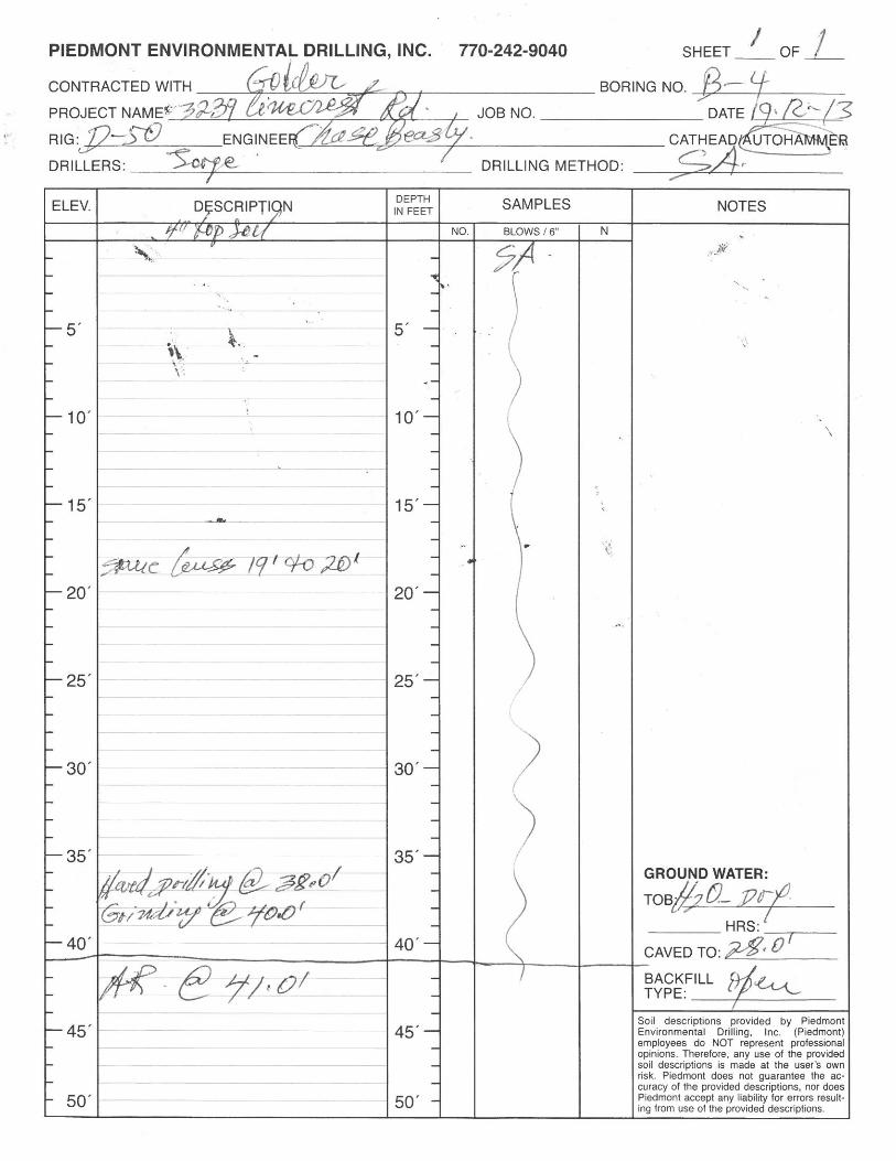
3.0 SUBSURFACE EXPLORATION PROCEDURES On December 19, 2013, Golder conducted a subsurface exploration in the footprint of the proposed surface mining borrow pit to evaluate general subsurface stratigraphy, primarily depths to auger refusal and groundwater. The following subsections describe the methodology of the exploration program. Approximate borehole locations are indicated on Figure 1 while Figure 2 represents the geologic profile of the borings.
3.1 Soil Borings Piedmont Environmental Drilling Inc. (Piedmont), under contract to Golder, performed the geotechnical drilling using an all-terrain rubber-track drill rig. Boreholes were advanced using 2.25-inch inner diameter hollow stem augers. Two of the boreholes were drilled in general accordance with ASTM D1586 and standard penetration tests (SPT) were performed using a split-barrel SPT sampler. Borings B-1 and B-2 are located in the northern portion of the property near Linecrest Road, while boring B-3 and B-4 are located in the eastern portion of the property near Bond Drive. Borings B-1 and B-3 were advanced from ground surface using hollow stem augers where SPT sampling was conducted at 10 foot intervals to a depth of 40 ft-bgs. Borings B-2 and B-4 were advanced from ground surface using hollow stem augers to depths of 50 and 41 ft-bgs, respectively, with no SPT sampling. Bag samples for B-2 and B-4 were taken at 25 foot intervals. Figure 1 shows the approximate borehole locations.
SPT sampling was only conducted at Borings B-1 and B-3 due to time constraints resulting from equipment failure of the all-terrain rubber-track drill rig. In order to achieve the desired number of borings, Borings B-2 and B-4 were advanced from ground surface using hollow stem augers without SPT sampling to expedite the drilling process. Samples obtained in Borings B-1 and B-3 were classified as residual soil. Borings B-2 and B-4 provided supplemental information with regard to the depth of groundwater, dense soil layers or rock lenses, and auger refusal.
G:\DeKalb County\2390081 Seminole Landfill\Production Drawings\Project 4 - Surface Mining Plan
Mrs. Hubson-Matthews January 7, 2014 Henry County Planning and Zoning 3 2390081003 During the subsurface exploration, a Golder engineer characterized soils encountered and recorded drilling observations on field borehole logs. The soils were identified and logged in general accordance with ASTM D2488 and Golder’s standard field procedures. In describing the soils, properties such as grain size, plasticity, color, consistency/compactness, moisture, and structure were recorded; details of the soils encountered during drilling are presented on Records of Boreholes in Attachment A and Figure 2 – Geologic Profile of Soil Borings. The presence and depths of groundwater infiltration were also recorded at the time of drilling, if observed. SPT soil samples were collected and stored in clean glass containers.
4.0 SITE SUBSURFACE CONDITIONS Materials encountered during the geotechnical exploration include: 3 to 4 inches of topsoil, residual soils, and bedrock/float rock. The distribution and characteristics of these materials and associated groundwater conditions are discussed in detail in the following subsections.
4.1 Residual Soils Residual soils in the Piedmont physiographic province are the result of in-place weathering of the parent bedrock. Residual soil was encountered in all four borings to depths ranging from 40 to 50 ft-bgs. Residual soils consisted of brown and gray silty sand and sandy silt with some mica and rock fragments. Silts encountered in this zone were generally low plasticity. SPT blow counts ranged from 13 to 53 bpf. Boring B-4 penetrated thin rock lenses at about 19 to 20 ft-bgs.
4.2 Auger Refusal Auger refusal is typically interpreted as the top of competent bedrock where no rock coring is performed but may indicate rock lenses or boulders suspended within soil or partially weathered rock (PWR). Typically, a zone of PWR will be encountered prior to auger refusal occurring in sound bedrock. Top of bedrock elevations in the Piedmont physiographic province vary considerably over short horizontal distances and, dependent on differential weathering and bedrock type, pinnacles of rock may be encountered above auger refusal depths. For these reasons, caution is recommended when considering auger refusal to represent top of bedrock.
Auger refusal was encountered in Boring B-4 at a depth of 41 ft-bgs with hard drilling noted initially at a depth of 38 ft-bgs.
4.3 Groundwater Groundwater measurements were taken 24 hours after the time of drilling. Stabilized groundwater levels may differ from those measured and seasonal fluctuations will occur. Groundwater levels were measured for Borings B-1 at 28 ft-bgs and B-2 at 33 ft-bgs. Borings B-3 and B-4 caved at depths of 31 and 32 ft-bgs, respectively. At 24 hours after the time of drilling no groundwater was present above the caved depth in either of these boreholes.
Backfilling was not completed in order to allow for future groundwater measurements to ensure more accurate field estimates of groundwater depth. The boreholes will be backfilled following the next round of groundwater measurements.
5.0 LIMITATIONS Findings presented in this report are based on data and samples from four discrete locations from the site. It is not uncommon for subsurface conditions to vary significantly over short horizontal and vertical distances. Regardless of the thoroughness of a subsurface exploration, there is the possibility that conditions between borings will differ from those at the boring locations.
Our professional services have been performed and our findings derived in accordance with generally accepted geotechnical engineering principles and standards. Golder is not responsible for the conclusions,
G:\DeKalb County\2390081 Seminole Landfill\Production Drawings\Project 4 - Surface Mining Plan

Mrs. Hubson-Matthews January 7, 2014 Henry County Planning and Zoning 4 2390081003 opinions, or recommendations of others based on these data. Our exploration and testing did not include any assessment or evaluation of environmental conditions or contamination in the soil, groundwater, or surface water.
6.0 SUMMARY AND CLOSING The geotechnical exploration was performed to provide a general characterization of subsurface conditions for the surface mining borrow pit along Linecrest Road. In Boreholes B-1 and B-2 conducted near Linecrest Road, residual soil was encountered, beneath a thin layer of topsoil, to depths of 40 and 50 ft-bgs. Auger refusal was not encountered in either borehole. Groundwater depths in these boreholes ranged from 28 to 33 ft-bgs, as measured 24 hours following drilling. In Borehole B-3 and B-4 near Bond Drive, residual soil was encountered to depths of 40 and 41 ft-bgs., with auger refusal in Borehole B-4 at 41 ft-bgs. No groundwater was present in Boreholes B-3 and B-4 above their caved depths of 31 and 28 ft-bgs, respectively.
In general, the findings of Golder’s geotechnical investigation indicate:
Bedrock may be present at depths of 40 ft-bgs or less; therefore, proposed excavation depths should be limited to a maximum of 40 ft-bgs.
The borings encountered residual soil throughout their depths. No deleterious material was encountered in the four boreholes performed for the investigation; however, other unexplored areas of the site may contain unsuitable material, particularly due to the previous development of the site for residential properties.
Groundwater was encountered at shallower depths close to Linecrest Road where groundwater was measured at 28 to 33 ft-bgs (corresponding to an elevation of approximately 932 ft-msl). Groundwater control will be necessary during the culvert replacement. Excavation/mining plans will be produced based on groundwater at approximately 28 ft-bgs near Linecrest Road and at similar elevations across the site.
We trust that this report is sufficient for your present requirements. Should you have any questions concerning this report, please do not hesitate to contact one of the undersigned.
Sincerely, GOLDER ASSOCIATES INC.
Steve J. Cribb, PE Kevin S. Brown, P.E. Senior Consultant and Associate Principal and Senior Consultant
Attachments:
Figure 1 – Approximate Location of Soil Borings
Figure 2 – Geologic Profile of Soil Borings
Attachment A – Soil Boring Logs
Attachment B – Important Information About Your Geotechnical Engineering Report
G:\DeKalb County\2390081 Seminole Landfill\Production Drawings\Project 4 - Surface Mining Plan

Mrs. Hubson-Matthews January 7, 2014 Henry County Planning and Zoning 5 2390081003 KSB/SJC
G:\DeKalb County\2390081 Seminole Landfill\Production Drawings\Project 4 - Surface Mining Plan

EXISTING CONDITIONS BASEMAP
EXCAVATION 10 FEET DEPTH
1
DEKALB COUNTY
SURFACE MINING PERMIT APPLICATION
SEMINOLE ROAD LANDFILL
TITLE
PROJECT
SCALEDESIGN
PROJECT No. FILE No.
CADD
CHECK
REVIEW
REVISION DESCRIPTION CADD CHK RVWDESDATEREV
G:\D
eK
alb
C
ou
nty\2
39
00
81
S
em
in
ole
L
an
dfill\P
ro
du
ctio
n D
ra
win
gs\P
ro
je
ct 4
- S
urfa
ce
M
in
in
g P
la
n\S
urfa
ce
M
in
in
g P
erm
it - B
ase
ma
p.d
wg
| L
ayo
ut: A
RC
H_
D_
FIG
UR
E_
LA
ND
SC
AP
E | M
od
ifie
d: C
Be
asle
y 1
2/0
4/2
01
3 2
:4
6 P
M | P
lo
tte
d: C
Be
asle
y ----
12/4/2013KGB
12/4/2013KGB
12/4/2013ACB
12/4/2013ACB AS SHOWN
Surface Mining Permit - Basemap
SHEET
2390081-003
REFERENCES / SPECIFICATIONS
NOTES
LEGEND
DRAFT - FOR DISCUSSION
PURPOSES
0
FEET
60 120 180
SCALE
1. AERIAL TOPOGRAPHIC INFORMATION PROVIDED BY BECKOM AERIAL MAPPING,
DATE OF AERIAL 8/23/2013.
2. GROUND RUN SURVEY INFORMATION PROVIDED BY MARTIN SURVEYORS,
DATED 10/24/2013. INFORMATION INCLUDES STORM WATER DITCHING AND
PIPING, FENCING AND PROPERTY LINES.
1. DRAWING TO BE USED FOR PLANNING PURPOSES.
PROPERTY BOUNDARY
EXISTING CONTOURS
EXISTING EDGE OF ROAD
EXISTING TREE LINE
EXISTING FENCE
EXISTING CHANNEL FLOW LINE
EXISTING POWER LINE
POWER LINE EASEMENT
980
ET ET