geotechnical site characterization of a mud eruption ... · geotechnical site characterization of a...
TRANSCRIPT

Geotechnical Site Characterization of a MudEruption Disaster Area Using CPTu for RiskAssessment and Mitigation (IPL-195)
Paulus P. Rahardjo, Adityaputera Wirawan, and Andy Sugianto
AbstractA mud eruption in East Java that occured on May 29, 2006 is well known worldwide. Themechanisms of the causes of the eruptions are still in debate, whether it was triggered bygas well drilling or by pressurised fluid reactivated by the Jogjakarta earthquake of May 26,2006. This debate is not the main issue in this report. Instead, this paper discusses mainlythe results of CPTu tests recently conducted and mitigation and risk reduction. The volumeof the mud discharge is estimated at 5000 m3. Dykes were constructed to contain the mud,which covered areas reaching 650 ha (Sofyan 2015). The location of the disaster is in themiddle of the town of Porong in the district of Sidoardjo, near Surabaya Internationalairport, and mud has blocked the major arterial roads from north to south of East Java. Thesoil condition of the site is deep soft clays which causes instability of the dykes. Some dykefailures occurred, endangering residential areas due to the flow of the mud (Rahardjo 2015).This paper describes the characterics of the soil conditions from a number of drillings andCPTu tests conducted by the authors for designing the replacement of the arterial road andfor dyke reinforcement, and also in the middle of the mud. The paper discuss thegeotechnical problems of land subsidence over large areas and differential settlement thatcause damage to infrastructure, including roads, gas pipes, railways, bridges and buildings,and is of particular importance to the safety of the dykes. The mud has been dischargedthrough the Porong River, and sedimentation is part of the problem.
KeywordsMud eruption � Soft soils � Geotechnical failures � Land subsidence � CPTu �Mitigationand risk reduction
P.P. Rahardjo (&) � A. Wirawan � A. SugiantoUniversitas Katolik Parahyangan, Jl. Ciumbuleuit No. 94,Bandung, 40142, Indonesiae-mail: [email protected]
A. Wirawane-mail: [email protected]
© The Author(s) 2017K. Sassa et al. (eds.), Advancing Culture of Living with Landslides,DOI 10.1007/978-3-319-59469-9_40
449
Introduction
The mud disaster that occurred in 2006 in east Java is aspecial event that is very rare. A mud eruption occured onMay 29, 2006 and is the biggest of its kind in the world. Itwas preceded by drilling for gas exploration in this area.However, until this day, there is still some speculation aboutwhether the eruption was triggered by the drilling or by theJogjakarta earthquake of May 26, 2006. It is still debated,but in recent discussions (Rahardjo 2015) Massini et al.(2010) claimed that there is a trend toward the opinion thatthe cause of the eruption is largely natural.
The disaster caused 14 fatalities, displaced 30,000 people(13,000 families), closed 30 factories and hundreds of smallbusiness, and flooded more than 10,000 homes with mud in
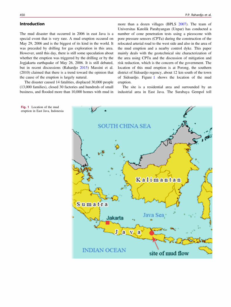
more than a dozen villages (BPLS 2007). The team ofUniversitas Katolik Parahyangan (Unpar) has conducted anumber of cone penetration tests using a piezocone withpore pressure sensors (CPTu) during the construction of therelocated arterial road to the west side and also in the area ofthe mud eruption and a nearby control dyke. This papermainly deals with the geotechnical site characterization ofthe area using CPTu and the discussion of mitigation andrisk reduction, which is the concern of the government. Thelocation of this mud eruption is at Porong, the southerndistrict of Sidoardjo regency, about 12 km south of the townof Sidoardjo. Figure 1 shows the location of the muderuption.
The site is a residential area and surrounded by anindustrial area in East Java. The Surabaya Gempol toll
Fig. 1 Location of the muderuption in East Java, Indonesia
450 P.P. Rahardjo et al.

highway Surabaya-Malang–Pasuruan Banyuwangi, which isan important economic route in East Java, is directly influ-enced by this mud eruption.
Despite of many efforts carried out to reduce the eruption,the scale of the disaster is beyond the capability of humanbeings. As a result, the last effort is merely defence to savethe lives of people by containing the mud in cells and to limitthe widening effect to the surrounding by pumping the mudinto the Porong River.
The disaster has become the world’s most destructivemud volcano (Wayman 2011). But at present, after almost9 years, the discharge has dropped in volume, and this giveshope that the eruption is almost over. Some geologists
however predicted that the flow of mud will end 30 yearsfrom the start of the disaster, so it seems that it is not certainand only a rather hasty conclusion.
The mud ejected through this volcano is hot, and forsamples collected nearby, temperatures are in the range of80–90 °C (Figs. 2, 3 and 4).
The Cause of the Mud Eruption
Prior to the mud eruption, there was drilling for gas explo-ration by a company in Indonesia, known as Banjar Panji 1(Fig. 5), which had reached about 3000 m depth. Richard
Fig. 2 The vent of the mud eruption in East Java, Indonesia, surrounded by protection dykes (Boston.com 2008)
Geotechnical Site Characterization of a Mud Eruption … 451
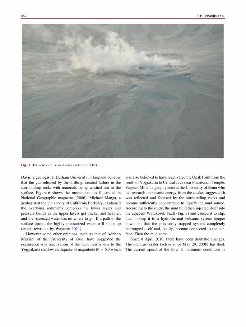
Davis, a geologist at Durham University in England believesthat the gas released by the drilling, created failure in thesurrounding rock, with materials being washed out to thesurface. Figure 6 shows the mechanism, as illustrated inNational Geographic magazine (2006). Michael Manga, ageologist at the University of California Berkeley, explainedthe overlying sediments compress the lower layers andpressure builds as the upper layers get thicker and heavier,and the squeezed water has no where to go. If a path to thesurface opens, the highly pressurized water will shoot up(article rewritten by Wayman 2011).
However some other opinions, such as that of AdrianoMazzini of the University of Oslo, have suggested theoccurrence was reactivation of the fault nearby due to theYogyakarta shallow earthquake of magnitude M = 6.3 which
was also believed to have reactivated the Opak Fault from thesouth of Yogjakarta to Central Java near Prambanan Temple.Stephen Miller, a geophysicist at the University of Bonn wholed research on seismic energy from the quake, suggested itwas reflected and focused by the surrounding rocks andbecame sufficiently concentrated to liquefy the mud source.According to the study, the mud fluid then injected itself intothe adjacent Watukosek Fault (Fig. 7) and caused it to slip,thus linking it to a hydrothermal volcanic system deeperdown, so that the previously trapped system completelyrearranged itself and, fatally, became connected to the sur-face. Then the mud came.
Since 8 April 2010, there have been dramatic changes.The old Lusi crater (active since May 29, 2006) has died.The current speed of the flow at minimum conditions is
Fig. 3 The center of the mud eruption (BPLS 2007)
452 P.P. Rahardjo et al.
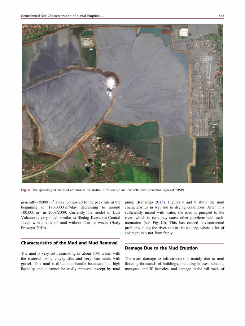
generally <5000 m3 a day, compared to the peak rate at thebeginning of 180,0000 m3/day decreasing to around100,000 m3 in 2008/2009. Currently the model of LusiVolcano is very much similar to Bledug Kuwu (in CentralJava), with a kick of mud without flow or waves (HadyPrasetyo 2010).
Characteristics of the Mud and Mud Removal
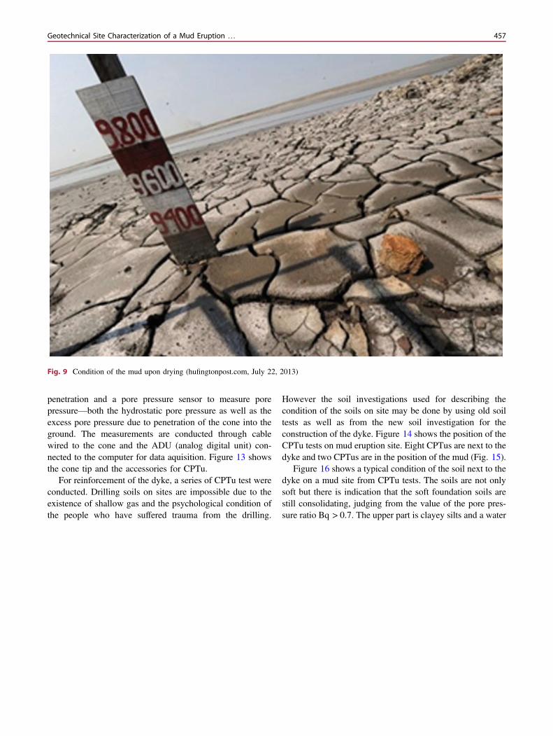
The mud is very soft, consisting of about 70% water, withthe material being clayey silts and very fine sands withgravel. This mud is difficult to handle because of its highliquidity and it cannot be easily removed except by mud
pump (Rahardjo 2015). Figures 8 and 9 show the mudcharacteristics in wet and in drying conditions. After it issufficiently mixed with water, the mud is pumped to theriver, which in turn may cause other problems with sedi-mentation (see Fig. 10). This has caused environmentalproblems along the river and at the estuary, where a lot ofsediment can not flow freely.
Damage Due to the Mud Eruption
The main damage to infrastructure is mainly due to mudflooding thousands of buildings, including houses, schools,mosques, and 30 factories, and damage to the toll roads of
Fig. 4 The spreading of the mud eruption in the district of Sidoardjo and the cells with protection dykes (CRISP)
Geotechnical Site Characterization of a Mud Eruption … 453

Surabaya-Gempol, Arterial Road Surabaya-Malang, and torailways, gas pipes, drainage canals and others structures,causing economic losses in the order of billions of US dol-lars. Both economic and social activities are significantlydirect or indirectly affected.
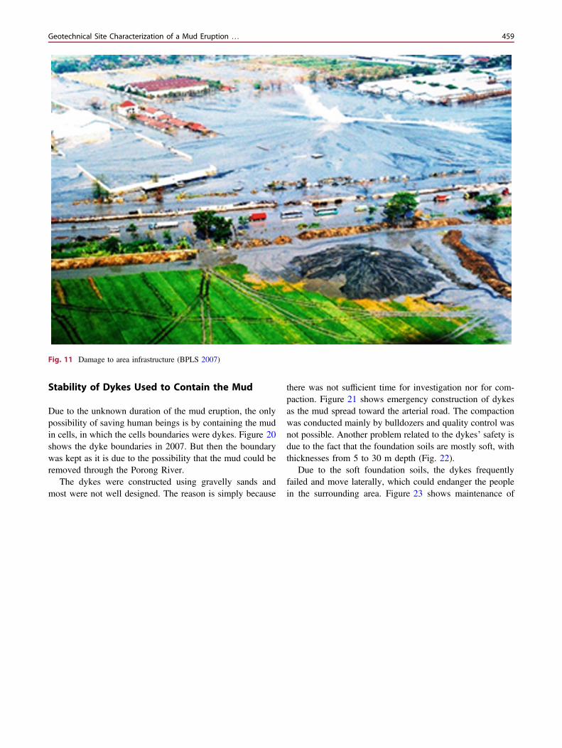
Figure 11 shows the range of spreading of the mud in2007, when the highway of Surabaya-Gempol was still inuse. The author reviewed the condition of the dyke, andwater had started seeping at the toe of the slope, whichmeant that the dyke was not safe. In the same year, thishighway was flooded by the mud and is no longer used(Rahardjo 2015).
Geotechnical Site Characterization UsingCPTu
Soil Conditions at the Site
Based on laboratory tests in this area, the soils are highlyplastic materials, with a natural water content ranging from40–100%. Generally the upper part is slightly stronger,showing slight overconsolidation. However the void ratiocould be as high as 1.5–3.0. Laboratory tests also show thatthe soft soils are still consolidating. Compressibility of thesoils, measured by its compression index is very high, with arange of 0.5–1.5, so the settlement is large (Soleman 2012)(Fig. 12).
Based on in situ testing (CPTu and SPT), the soil upperlayers are very soft, with a thickness of 15–25 m, dominatedby clays to silts and silty sands. The silty sands are mixedwith clay. This soil condition has a very low bearingcapacity and may cause very substantial settlement uponloading. The possibility of squeezing of lower soil layers areamong the problems that need to be considered.
CPTu Tests at the Mud Site
The use of CPTu (Cone Penetration Test with pore pressuremeasurement) has been popular in Indonesia since 1990,especially for soft soils. The increasing use of the CPTu isdue to a number of factors:
• It is handy, fast and accurate for soil profiling and notdependent on the operators.
Fig. 5 Photograph of Banjar Panji 1 well (Didiek Djarwadi 2015)
Fig. 6 The mechanism of the start of mud eruption (NationalGeographic 2006)
454 P.P. Rahardjo et al.
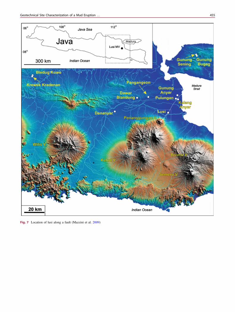
Fig. 7 Location of lusi along a fault (Mazzini et al. 2009)
Geotechnical Site Characterization of a Mud Eruption … 455

• It can distinguish both the soil resistance and the porepressure, hence the effective reaction of the soils can bemeasured and it can recognize the drained and undrainedresponse of the soils.
• The interpretation of soil properties, although heavilyreliant on empirical correlation, are accurate due to themany available measurements for comparison andjustification.
• Dissipation tests can be conducted to measure the per-meability and consolidation characteristics of the soils,
which provides more reliable methods compared to lab-oratory tests.
The authors have gained a lot of experience in manyprojects throughout the northern coast of Jakarta and also inmany places where soft soil deposits create instability duringconstruction and the problems of long-term settlement.
The equipment consists of an electronic cone with conetip to measure tip resistance, a friction sleeve to measurefriction resistance of the soils during the course of
Fig. 8 The visual appearance of the wet mud (BPLS 2007)
456 P.P. Rahardjo et al.
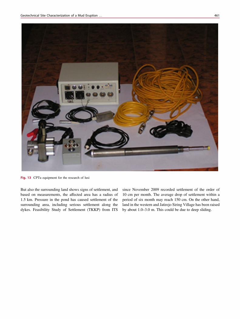
penetration and a pore pressure sensor to measure porepressure—both the hydrostatic pore pressure as well as theexcess pore pressure due to penetration of the cone into theground. The measurements are conducted through cablewired to the cone and the ADU (analog digital unit) con-nected to the computer for data aquisition. Figure 13 showsthe cone tip and the accessories for CPTu.
For reinforcement of the dyke, a series of CPTu test wereconducted. Drilling soils on sites are impossible due to theexistence of shallow gas and the psychological condition ofthe people who have suffered trauma from the drilling.
However the soil investigations used for describing thecondition of the soils on site may be done by using old soiltests as well as from the new soil investigation for theconstruction of the dyke. Figure 14 shows the position of theCPTu tests on mud eruption site. Eight CPTus are next to thedyke and two CPTus are in the position of the mud (Fig. 15).
Figure 16 shows a typical condition of the soil next to thedyke on a mud site from CPTu tests. The soils are not onlysoft but there is indication that the soft foundation soils arestill consolidating, judging from the value of the pore pres-sure ratio Bq > 0.7. The upper part is clayey silts and a water
Fig. 9 Condition of the mud upon drying (hufingtonpost.com, July 22, 2013)
Geotechnical Site Characterization of a Mud Eruption … 457
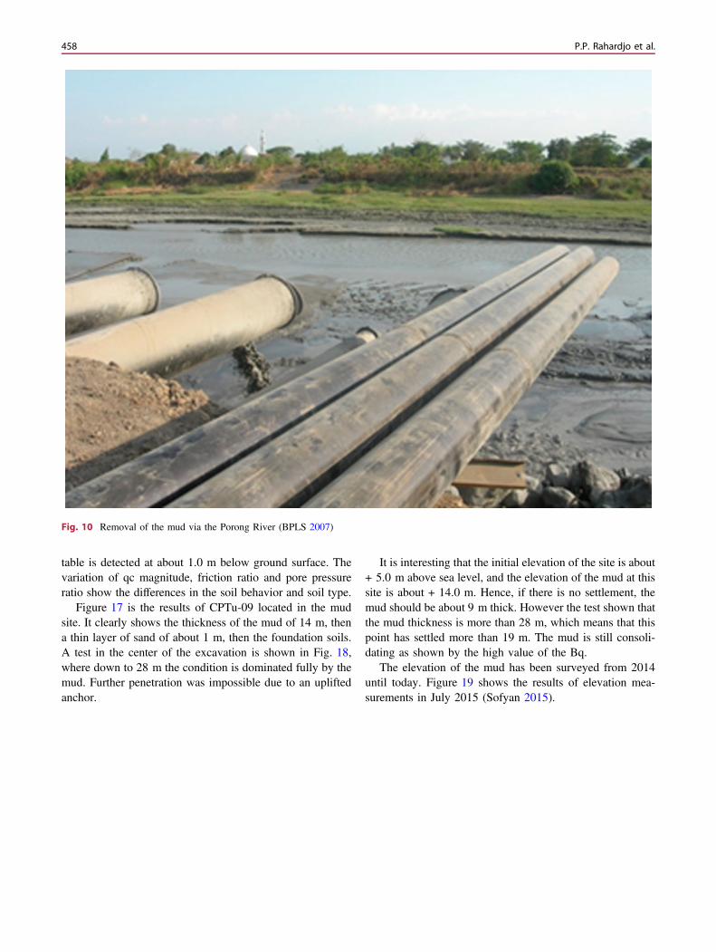
table is detected at about 1.0 m below ground surface. Thevariation of qc magnitude, friction ratio and pore pressureratio show the differences in the soil behavior and soil type.
Figure 17 is the results of CPTu-09 located in the mudsite. It clearly shows the thickness of the mud of 14 m, thena thin layer of sand of about 1 m, then the foundation soils.A test in the center of the excavation is shown in Fig. 18,where down to 28 m the condition is dominated fully by themud. Further penetration was impossible due to an upliftedanchor.
It is interesting that the initial elevation of the site is about+ 5.0 m above sea level, and the elevation of the mud at thissite is about + 14.0 m. Hence, if there is no settlement, themud should be about 9 m thick. However the test shown thatthe mud thickness is more than 28 m, which means that thispoint has settled more than 19 m. The mud is still consoli-dating as shown by the high value of the Bq.
The elevation of the mud has been surveyed from 2014until today. Figure 19 shows the results of elevation mea-surements in July 2015 (Sofyan 2015).
Fig. 10 Removal of the mud via the Porong River (BPLS 2007)
458 P.P. Rahardjo et al.
Stability of Dykes Used to Contain the Mud
Due to the unknown duration of the mud eruption, the onlypossibility of saving human beings is by containing the mudin cells, in which the cells boundaries were dykes. Figure 20shows the dyke boundaries in 2007. But then the boundarywas kept as it is due to the possibility that the mud could beremoved through the Porong River.
The dykes were constructed using gravelly sands andmost were not well designed. The reason is simply because
there was not sufficient time for investigation nor for com-paction. Figure 21 shows emergency construction of dykesas the mud spread toward the arterial road. The compactionwas conducted mainly by bulldozers and quality control wasnot possible. Another problem related to the dykes’ safety isdue to the fact that the foundation soils are mostly soft, withthicknesses from 5 to 30 m depth (Fig. 22).
Due to the soft foundation soils, the dykes frequentlyfailed and move laterally, which could endanger the peoplein the surrounding area. Figure 23 shows maintenance of
Fig. 11 Damage to area infrastructure (BPLS 2007)
Geotechnical Site Characterization of a Mud Eruption … 459

dykes in the center, which now has reached 25 m high dueto the continuous settlement. As the dykes became higher,stability has become particular concern. To reduce theamount of fill, large sandbags have been used in the fillembankment.
A study was conducted by Augustawijaya et al. (2012) toanalyse the stability of the dykes. The particular location forhis study was the dyke at number 10D. The results show thatthe stability is marginal.
In August 22, 2010, a particular accident accompanied asudden flood landslide (like a cold lahar) in the south east, a
phenomena that has occured in debris flows and sedimentgravity flows (Hardy Prasetyo 2010). In a matter of minutes,three dredgers that were operating there were driven as far as200 m from their original position (Figs. 24 and 25).
Land Subsidence and Settlement Problems
At the center of the vent, the land sank because so muchwater and mud from beneath the ground was erupted. Tomaintain the height of the dykes, large sandbags were used.
Fig. 12 Damage to houses in the muddy flood (BPLS 2007)
460 P.P. Rahardjo et al.
But also the surrounding land shows signs of settlement, andbased on measurements, the affected area has a radius of1.5 km. Pressure in the pond has caused settlement of thesurrounding area, including serious settlement along thedykes. Feasibility Study of Settlement (TKKP) from ITS
since November 2009 recorded settlement of the order of10 cm per month. The average drop of settlement within aperiod of six month may reach 150 cm. On the other hand,land in the western and Jatirejo Siring Village has been raisedby about 1.0–3.0 m. This could be due to deep sliding.
Fig. 13 CPTu equipment for the research of lusi
Geotechnical Site Characterization of a Mud Eruption … 461

Mitigation and Implementation
There are a number of geotechnical problems that must besolved, including the safety of the dykes, settlement or landsubsidence, and risk of overflow. For dyke safety, it shouldbe monitored visually as well as using instruments such assettlement points, inclinometers and pizometers. Thoseinstruments will serve to measure the performance of the
dyke, as well as act as a warning system if the dyke is notstable.
For subsidence it is necessary continuously monitor alarge area. The land subsidence may damage houses andhence the boundary of the area that is influenced shall berelocated. For transportation toward Malang, a new arterialroad has been completed. The relocation is to west side,assuming that the east side has lower elevation.
Fig. 14 Location of CPTu tests
462 P.P. Rahardjo et al.

ConclusionsBased on the study, some conclusions are made:
• The soil conditions underneath the mud eruption and thearea of mud containment are generally very soft. Thiscondition causes serious problems with stability andsubsidence. In most cases, the soils are still consolidatingand are sensitive to disturbance. Additional loading willbe very dangerous and may trigger dyke failures.
• The first year of the study has been basically to identifythe geotechnical problems of the mud eruption disaster.
We need more detailed studies of awareness andpreparedness.
• CPTu is the best tool to study the mud conditions, as wellas the foundation soils.
• There is a chance for improvement due to the significantdecrease in mud discharge. Reclamation may be pro-posed. At least in part it will be possible to compress themud into a stronger layer along the periphery of the dyke.
• The mud discharge to Porong River may cause long-termproblems due to sedimentation along the river and in theestuary area.
Fig. 15 Location of the CPTus tests on mud sites
Geotechnical Site Characterization of a Mud Eruption … 463
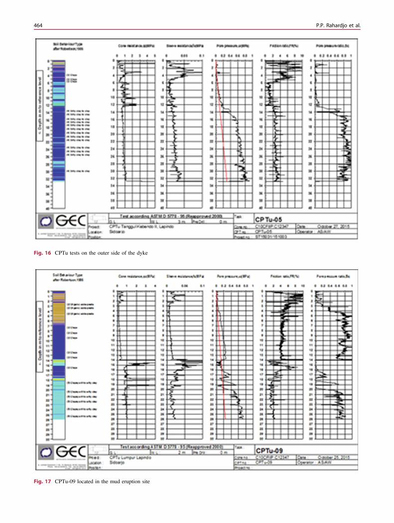
Fig. 16 CPTu tests on the outer side of the dyke
Fig. 17 CPTu-09 located in the mud eruption site
464 P.P. Rahardjo et al.

It is suggested to install geotechnical monitoring sys-tem which will provide information on the performanceof the dykes.
Acknowledgements The authors appreciate the assistance of Lem-baga Penelitian dan Pengabdian Masyarakat (LPPM) of ParahyanganCatholic University for providing funds to do work on this research andto BPLS and engineers of PT GEC for providing information and data.
Fig. 18 CPTu at the center of the mud eruption
Geotechnical Site Characterization of a Mud Eruption … 465
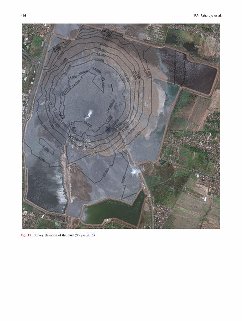
Fig. 19 Survey elevation of the mud (Sofyan 2015)
466 P.P. Rahardjo et al.

Fig. 20 Boundaries of cells to contain the mud (Tim Nasional 2007)
Geotechnical Site Characterization of a Mud Eruption … 467
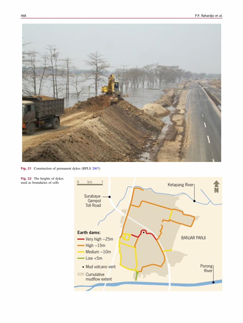
Fig. 21 Construction of permanent dykes (BPLS 2007)
Fig. 22 The heights of dykesused as boundaries of cells
468 P.P. Rahardjo et al.
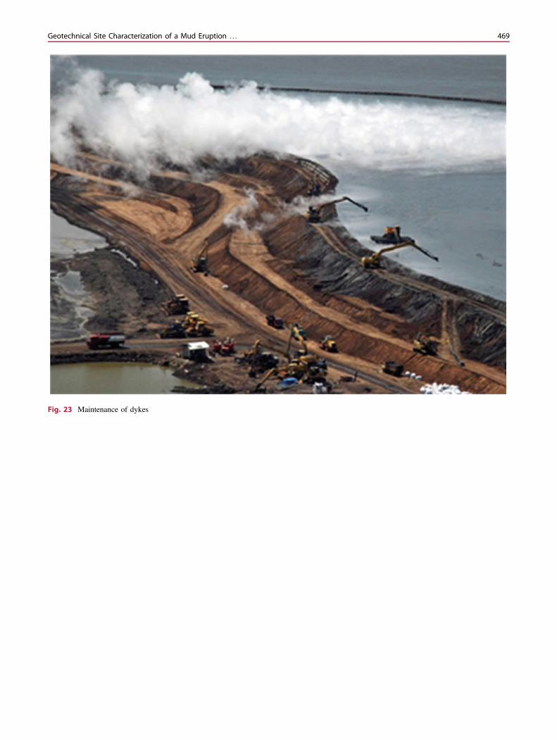
Fig. 23 Maintenance of dykes
Geotechnical Site Characterization of a Mud Eruption … 469

Fig. 24 Geotechnical cross section of foundation soils (Augustawijaya et al. 2012)
Fig. 25 Cross section of dykes(Augustawidjaja 2012)
470 P.P. Rahardjo et al.

References
Agustawijaya DS, Sukandi (2012) The stability analysis of the Lusimud volcano embankment dams using FEM with special referenceto the dam point P10D. Civ Eng Dimension 14(2):100–109
BPLS (Badan Penangulangan Lumpur Sidoardjo) (2007) Personalcommunication with Mr. Sofyan
Boston.com (2008) Sidoardjo’s man-made mud volcanoGEC PT (2009) Soil investigation report using CPTU for the alternative
by pass road at Porong (Report)Guntoro A (2011) Understanding the origin of Sidoardjo mud volcano
in relation to longevity estimation based on regional study andseismic interpretation. Lectures at Geological Department TrisaktiUniversity, Jakarta
Kompas (2010) Lapindo mud resulted in building fracture, Surabaya,22 June 2010
Rahardjo PP (2011) Geotechnical aspect of Sidoardjo mud eruption (inIndonesian), report, Center for Infrastructures and Urban Develop-ment, Parahyangan Catholic University
Rahardjo PP (2015) Geotechnical aspect of mud eruption disaster inEast Java. In: Proceeding 19th Asian regional conference on soilmechanics and foundation engineering, Fukuoka, Japan
Mazzini A, Nermoen A, Krotkiewski M, Podladchikov S, Planke S,Svensen H (2009) Strike-slip faulting as a trigger mechanism foroverpressure release through piercement structures: implications forthe lusi mud volcano, Indonesia. Mar Petrol Geol 26(9):1751–1765
Sofyan (2015) Report on the latest situation of Lumpur Sidoardjo. In:Proceedings international conference on landslides and slopestability, Bali
Soleman AR (2012) Karakterisasi Tanah Lempung Lunak di PorongSidoardjo berdasarkan Uji CPTu dan Uji Laboratorium, tesisMagister. Universitas Katolik Parahyangan, Bandung
Wayman E (2011) The World’s Muddiest disaster, Smithsonian.com, 2Dec 2011
Open Access This chapter is licensed under the terms of the CreativeCommons Attribution 4.0 International License (http://creativecommons.org/licenses/by/4.0/), which permits use, sharing,adaptation, distribution and reproduction in any medium or format, aslong as you give appropriate credit to the original author(s) and thesource, provide a link to the Creative Commons license and indicate ifchanges were made.
The images or other third party material in this chapter are included inthe chapter’s Creative Commons license, unless indicated otherwise ina credit line to the material. If material is not included in the chapter’sCreative Commons license and your intended use is not permitted bystatutory regulation or exceeds the permitted use, you will need toobtain permission directly from the copyright holder.
Geotechnical Site Characterization of a Mud Eruption … 471