geothermal country update for perú, 2010-2014 world geothermal congress 2015 melbourne, australia,...
TRANSCRIPT

Proceedings World Geothermal Congress 2015
Melbourne, Australia, 19-25 April 2015
1
Geothermal Country Update for Peru, 2010-2014
Vicentina Cruz1, Victor Vargas
2
1Instituto Geológico Minero y Metalúrgico - INGEMMET, Av. Canadá Nº 1470, San Borja Lima 41, Perú, Apartado 889
2(Formerly INGEMMET), EDC Peru Holdings SAC – EPHS, Av. Manuel Olguín 335 – Of. 1301 – Santiago de Surco, Lima 33,
Perú ([email protected])
Keywords: Peru, Pacific Rig, Eje Volcánico Sur, Authorized Areas, Surface Exploration, Geothermal, Hydro
ABSTRACT
Peru is one of the countries in South America with greatest geothermal potential because it is located within the Pacific Ring of
Fire, where the subduction process occurs between the Nazca and South American Plates. This is the key factor in the formation of
the Andes Cordillera (Andean Mountain Range) located in the southern part of Peru, where many active volcanoes can be found.
Consequently, the magmatic and tectonic processes have allowed the development of geothermal environments in this region.
The evaluation of the Peruvian geothermal potential begun in the 70´s where most of the studies were undertaken by government
institutions, with some technical assistance from countries that have developed geothermal activities.
Six geothermal regions have been identified in Peru. The most promising of these is the region 5, also called “Eje Volcánico Sur”,
where all the actives volcanoes are located. Whereas, the other five regions have good potential for low and moderate enthalpy
resources. Historically Peru has developed activities in the direct uses of the geothermal resources, mainly in balneology, where
some hot springs have been used since the Inca´s Empire.
Since 2007, Peru has been receiving economical and technical assistance to start the development of geothermal energy. It was in
this year that the Japanese government supported the pre-feasibility studies in two of the most promising geothermal fields in the
country, Calientes and Borateras, where 150 MWe were estimated to be found. In 2010, the Japanese government also elaborated
“The Master Plan for Development of Geothermal Energy in Peru” where they studied 15 geothermal fields and 3,000 MWe was
the first estimated of the geothermal potential of the country.
Peru, is one of the two South American countries (the other is Chile), that has geothermal legislation. The Geothermal Law in Peru
was published in 1997 and its newest By-laws were published in 2010. As a result, many geothermal companies have looked into
investing in Peru as a good opportunity to develop the geothermal resources. There are many private companies exploring
geothermal resources currently in Peru. The government has granted more than 30 authorizations areas, most of them located in
southern Peru.
However, until now no electricity from geothermal resources has been produced and there have not been any drilling for production
wells done in the country.
1. INTRODUCTION
Peru is a democratic, social, independent and sovereign nation, located in the central and western part of South American, between
81°19’35” and 68°30’11” west longitude, and 0°01’48” to 18°21’05” south latitude (Fig 1). There are 30 135 875 habitants living
in a territory of 1 285 216 km2 (INEI, 2012); the official language is Spanish and there is a significant segment of the population
speaks Quechua, Aymara and several dialects in the Amazonic jungle.
The complex geography of the country has allowed characterizing and dividing in three main regions, these are called: Costa, Sierra
and Selva. The first one is located close to the Pacific Ocean and is predominated by an arid desert. The second has the main feature
that Peru has, The Andes Mountain or “Cordillera de los Andes”, caused by the subduction process occurs between the Nazca and
South American Plates, the volcanic range is located inside it. And the third one is the characterized by the Amazon jungle.
As a result, Peru is one of the countries with more biodiversity around the world and a large variety of mineral resources, in
addition to the variety of renewable energy resources throughout its territory. For the case of geothermal energy the most
promissory areas are located in the southern part.
In 2008, the Ministry of Energy and Mines approve of the Legislative Decree N°1002 for the promotion of investment in electricity
generation using renewable energy, with the aim of promoting the use of renewable energy, eliminating any barrier or obstacle to
development, allowing the diversification of the energy mix, constituting a step towards a policy of energy security and
environmental protection.
Moreover, the initiative of this standard, is to give additional benefits such as the implementation of a framework for promoting
private investment by removing barriers to this energetic activity, preservation of the environment with clean energy production,
helping to achieve positive effects globally and at the same time, achieve a minimum status of development of the Peruvian
economy, which requires greater security in energy availability.

Cruz et al.
2
Regarding geothermal energy in 1997, the Ministry Energy and Mines approved the Organic Law of Geothermal Resources (Law
No. 26848) and then in 2010 approved the Regulations for this law (MEM, 2010). The Law and Regulation promote the rational
development of geothermal resources in order to ensure the supply of energy required for economic growth, well-being and
efficient diversification of the Peruvian Energy´s matrix (increase new energy sources) and cautious development of the
aforementioned activities, their access and competition, according to the existed regulations.
Figure 1: Location of Peru.
The first steps to develop the geothermal resources in countries like Peru, has been supported by developed geothermal countries.
In this context in 2007 through coordinating with the Peruvian Agency for International Cooperation, Japan International
Cooperation Agency - JICA gave to Peru the international technical assistance to develop the pre-feasibility studies of two major
geothermal areas in the south, located in the Tacna region Calientes and Borateras (Fig. 2 and 3). After that in 2010, the Peruvian
government accepted and received the cooperation from JICA to develop the project called “The Master for the development of the
Geothermal Energy in Peru”.
In the following pages we present an overview of Peru´s geological setting, a description of the geothermal resources and potential,
together with the history of exploration, the state of geothermal utilization and a discussion of the actual and future development.
Figure 2: View of geothermal manifestations in Calientes.
2. GEOLOGICAL SETTING
Peru is part of the Central Andes that constitutes a typical mountain range, associated to subduction process between the Nazca and
South American Plates. The chain has a high topography and is characterized by a calc-alkaline magmatic arc; witness an active
subduction since at least 200 million years. The big morphostructural units are: the Coastal Zone, the Western Cordillera, the
Altiplano, the Eastern Cordillera, the Sub-Andean Zone and Plain Amazonic.
The Peruvian Andes comprise a set of mountain range emplaced between the Peruvian-Chilean Trench and Amazon plain. All the
stratigraphy, structure, magmatism, mineralization and seismicity of the Andes of Peru and are directly or indirectly the result of the
subduction process.
The geological history in Peru is very complex. Along the country very old rocks, whose ages reach 2000 Ma. has been emplaced.
At that era, the Amazon or Southamerica did not have the current territories of the Coast Zone and the West Range. These lands

Cruz et al.
3
have been accreted (united) to Southamerica 1,000 million years ago, by effect of plate movements and collisions that have
occurred. Indeed, geological studies have shown that the Arequipa massif in southern and Paracas block in the north have collided
with the Amazon. Product of these collisions there are evidence of deformed rocks, metamorphosed and a main suture zone that
corresponds to fault system Carabaya mountain range in the south and the Marañón River fault system Cerro de Pasco in the north.
It is these large sutures having a main control of large mineral deposits (Carlotto et al., 2009).
The geodynamic process that has endured Peru has developed in two periods clearly identified by the various geological events that
occurred in them. The first, during the Paleozoic, and the second with the evolution of the Andean Mountain range, that occurred
during the Triassic-Pleistocene.
However, in the Cenozoic period corresponds to the large Andean uplift, initiated in the late Paleozoic, a large development in the
early Cenozoic, extending to the present. Where large fault systems that behave as reverse faults and course are evident, produce
important deformations, erosion and filling of synorogenic basins, as well as the emplacement of volcanic products and formation
of batholiths, such as case, Andahuaylas-Yauri or Cordillera Blanca batholith. All this magmatism linked to the subduction of the
Nazca plate, is the main factor of the varied mineralizations that occur throughout the Peruvian´s Andean Mountains, and large
faults are structures that have been controlled these mineralizations. As part of thi geological settings, the structural systems and
active volcanism in the southern Peru are related to our great geothermal potential.
In the Miocene, the deformation moves towards the Sub-Andean Zone that suffers a strong deformation between 15 million years
and the current. These fault systems as of the Sub-Andean Front, continues and folded system forms that favoring the formation of
certain mineral deposits like those of Pb-Zn, but especially oilfields and gas.
Figure 3: Panoramic view of Borateras geothermal manifestations area.
Figure 4: Volcanic trend in southern Peru.
In the early Pliocene was given a renewed uplift of the Andes, reaching heights that exceed 3,000 m., accompanied by a mainly
andesitic volcanic activity and gradually circumscribed to the southern part. Local sequences develop around many volcanic

Cruz et al.
4
apparatus, with explosive and effusive phases, forming stratovolcanoes that align with a N-NW direction. In the high parts of the
Western Mountain range, from Northern of Chile to 13° S approximately, the alignment of volcanic apparatus known as the
"Barroso Arc", the same as continuous during the Pleistocene. In the Oriental Mountain range South of Peru, produced a fissure
volcanism of the acid explosive type, registering ignimbritas with ages from 4 to 5 Ma.
During the Quaternary, and as part of continue geological process, along the territory many and several deposits as many volcanic
sediments, glacial, alluvial, lacustrine, marine, and wind has been deposited.
The volcanic Pleistocenic deposits and recent, corresponding to the volcanic ejections glaciation later that are present in southern
Peru linked to the volcanic apparatus of the “Cordillera del Barroso”. The volcanic chain forms part of the Western Cordillera range
following an apparent alignment with NW-SE orientation in Peru and N-S in the north of Chile. The geometric characteristics of
each of the volcanoes that make up this chain, show that tectonic activity is contemporaneous to the extensional orogeny that
experiment the Andean Mountain range close to the Middle and Recent Quaternary (Sebrier et al, 1985). The main volcanoes
present in the southern region of Peru are: Paucarani, Tutupaca, Yucamane in Tacna; Ubinas, Ticsani, Huaynaputina in Moquegua,
the Chachani, Misti, Ampato, Hualca Hualca, Sabancaya and volcanic belt Andahua in Arequipa, and Quimsachata in the Vilcanota
valley (Cusco). These volcanoes had effusive and explosive phases of activity (Fig. 4).
Is important to remark that in the Northern and Central regions of Peru, volcanic activity ceased 8 million years ago (Marocco,
1980). Furthermore, the extensive Quaternary volcanism, favors the presence of anomalous high heat flow along the Peruvian
Andes, with geothermal surface manifestations through hot springs, mud pools, fumaroles and steam sources.
Peru has geological map to 1:1000 000 scale (Fig. 3), that is continuously updated by INGEMMET. Also, during the last ten years
this map has been started to update, the update scale are 1:50,000 and 1:100,000. From 12° to 18°30´ south latitude, all the geologic
sheets has been updated. Then, through some project with Universities or another institutions some sheets in the northern and
central country also have been updated.
Figure 5: Peruvian Geological Map.
3. GEOTHERMAL RESOURCES AND POTENTIAL
The first geothermal studies in Peru began in the 70’s with the first inventory of mineral and thermal springs realized by Mining
and Metallurgical Geologic Institute (INGEMMET). Since then, several studies have been made, such as follows:
In 1975, MINERO PERU carried out preliminary studies of exploration of geothermal manifestations in Calacoa and Salinas zones
in Moquegua.
In 1976, Geothermal Energy Research of Japan, conducted preliminary exploration work on Vilcanota basin in Cusco.
In 1977, INIE carried out the first census of the geothermal manifestations.
In 1978, INGEMMET compiled an inventory and geographic clustering of geothermal regions.
Cruz et al.
5
In 1979 and 1980, INGEMMET and AQUATER (Italy company), conducted geothermal reconnaissance studies in Region V,
where is located the geothermal region called “Eje Volcánico Sur”.
In 1980, Geothermal Energy System Ltd. developed geothermal studies in Calacoa and Salinas zones, located in in Moquegua
region and Tutupaca zone in Tacna region.
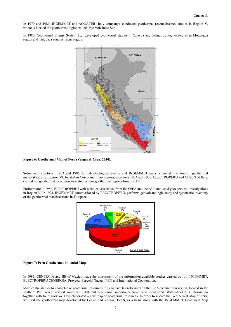
Figure 6: Geothermal Map of Peru (Vargas & Cruz, 2010).
Subsequently between 1983 and 1985, British Geological Survey and INGEMMET made a partial inventory of geothermal
manifestations of Region VI, located in Cusco and Puno regions, moreover 1983 and 1986, ELECTROPERU and CESEN of Italy,
carried out geothermal reconnaissance studies four geothermal regions from I to IV.
Furthermore in 1986, ELECTROPERU with technical assistance from the OIEA and the NU conducted geochemical investigations
in Region V. In 1994, INGEMMET commissioned by ELECTROPERU, performs geovolcanologic study and systematic inventory
of the geothermal manifestations in Tutupaca.
Figure 7: Peru Geothermal Potential Map.
In 1997, CENERGÍA and IIE of Mexico made the assessment of the information available studies carried out by INGEMMET,
ELECTROPERU CENERGIA, Proyecto Especial Tacna, IPEN and International Cooperation.
Most of the studies to characterize geothermal resources in Peru have been focused on the Eje Volcánico Sur region, located in the
southern Peru where several zones with different geothermal importance have been recognized. With all of this information
together with field work we have elaborated a new map of geothermal resources. In order to update the Geothermal Map of Peru,
we used the geothermal map developed by Cossio and Vargas (1979), as a basis along with the INGEMMET Geological Map
Cruz et al.
6
information at a 1:1´000,000 scale, which was updated in 1999. In addition the Thermal and Mineral springs Inventory Map
updated in 2003 and the Volcanic Map of Peru developed in 1997 by Fidel et al. (1997) was also considered. With all these
elements we re-defined the boundaries of six geothermal regions (Fig. 6), that was presented in WGC 2010 in Bali.
On the other hand, in 2007, the Ministry of Energy and Mines of Peru through of Peruvian Agency for International Cooperation-
APCI, manage to get, the technical support of the Japan government to develop geothermal energy in the country. In this
opportunity two Japanese banks finance, the pre-feasibility studies in the geothermal fields Borateras and Calientes. As a result of
these studies the geothermal potential for Borateras and Calientes were estimated in 50MWe and 100 MWe respectively.
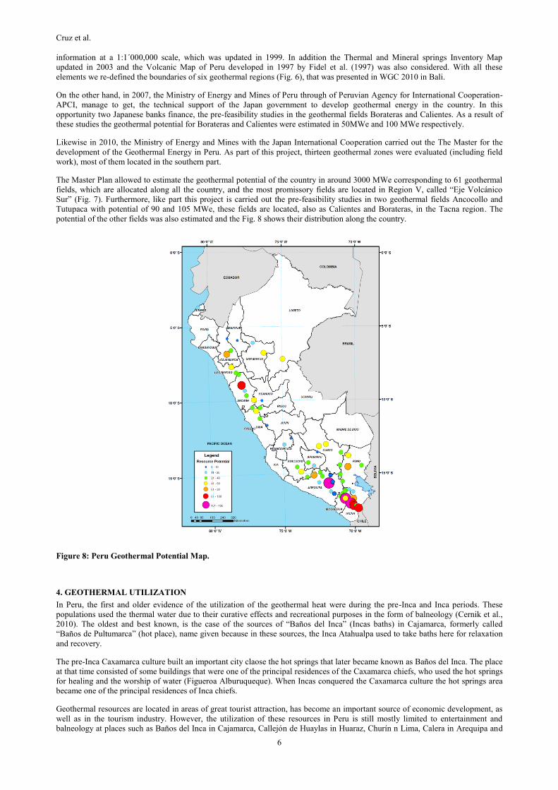
Likewise in 2010, the Ministry of Energy and Mines with the Japan International Cooperation carried out the The Master for the
development of the Geothermal Energy in Peru. As part of this project, thirteen geothermal zones were evaluated (including field
work), most of them located in the southern part.
The Master Plan allowed to estimate the geothermal potential of the country in around 3000 MWe corresponding to 61 geothermal
fields, which are allocated along all the country, and the most promissory fields are located in Region V, called “Eje Volcánico
Sur” (Fig. 7). Furthermore, like part this project is carried out the pre-feasibility studies in two geothermal fields Ancocollo and
Tutupaca with potential of 90 and 105 MWe, these fields are located, also as Calientes and Borateras, in the Tacna region. The
potential of the other fields was also estimated and the Fig. 8 shows their distribution along the country.
Figure 8: Peru Geothermal Potential Map.
4. GEOTHERMAL UTILIZATION
In Peru, the first and older evidence of the utilization of the geothermal heat were during the pre-Inca and Inca periods. These
populations used the thermal water due to their curative effects and recreational purposes in the form of balneology (Cernik et al.,
2010). The oldest and best known, is the case of the sources of “Baños del Inca” (Incas baths) in Cajamarca, formerly called
“Baños de Pultumarca” (hot place), name given because in these sources, the Inca Atahualpa used to take baths here for relaxation
and recovery.
The pre-Inca Caxamarca culture built an important city claose the hot springs that later became known as Baños del Inca. The place
at that time consisted of some buildings that were one of the principal residences of the Caxamarca chiefs, who used the hot springs
for healing and the worship of water (Figueroa Alburuqueque). When Incas conquered the Caxamarca culture the hot springs area
became one of the principal residences of Inca chiefs.
Geothermal resources are located in areas of great tourist attraction, has become an important source of economic development, as
well as in the tourism industry. However, the utilization of these resources in Peru is still mostly limited to entertainment and
balneology at places such as Baños del Inca in Cajamarca, Callejón de Huaylas in Huaraz, Churín n Lima, Calera in Arequipa and

Cruz et al.
7
Aguas Calientes in Tacna. Today, the use of geothermal sources in balneology activities (hotels, spas and recreation) has increased
in our country, from the simple and rustic local, this activity is developing, through using traditional techniques to the construction
of hotel and major recreational facilities, in several cases the infrastructure in the thermal spas and surroundings are poor.
On the other hand, since 2006, the Geological, Mining and Metallurgical Institute based in Supreme Decree, D.S. N° 05-2005-
MINCETUR, now Law Regulation of the hydro resources, Law N° 29338, has undertaken the certification and physic-chemistry
classification of the waters, for tourism use.
Summarizing, the direct uses of the geothermal resources in balneology or recreation are well known and more-less well
development in the country, but as until now non-official government entities has a complete inventory of these resources their
thermal potential has not been estimated.
As was mentioned in the item 3, Peru is a country that could be considered with a great geothermal potential, but until now no
geothermal power plant has been built or installed. According with the General Direction of Electricity from the Ministry of Energy
and Mines (DGE-MEM) more than 30 geothermal authorization for exploration has been granted but no company has drilled any
geothermal well (exploratory or slim holes).
Efforts to develop geothermal resources are being performed by companies awarded with authorization to carry surface exploration.
Geotérmica Quellaapacheta Peru SAC, EDC Energía Verde SA and ENEL Green Power are in the first stage to find and develop
geothermal resources. Superficial exploration campaigns (geological, geochemical and geophysical) are being carried out, at
southern Peru mainly.
It seems that one of the three companies - Geotérmica Quellaapacheta Peru SAC - GQPS, is moving into phase two of the
exploration authorization, as per the DGE-MEM, at the beginning of this year GQPS filed their intention to continue with
exploration activities, drilling of three wells need to be drilled as per current regulations.
5. DISCUSSIÓN
In the past 18 years, the Gross Domestic Product GDP has grown at an average annual rate of 5.3%, growth is sustained by the
dynamism of various activities (mining, industry, manufacturing, etc.); which in turn is reflected in higher electricity demand. The
Peruvian electricity market has achieved a significant development that has allowed accompanying the country's economic growth.
The electricity market has a generation park made up by 45 power plants with a capacity higher than 18 MW, which, in the
aggregate, account for an installed capacity of 6963 MW. This group includes 23 hydropower plants that total 3152 MW, and 28
thermal power plants that total 3811MW. Nine out of the thermal power plants operate with natural gas and reach 2658 MW.
The Table 01 shows the Present and Planned Production of Electricity until 2014, here is possible to see that until 2020 the
Peruvian government does not expect that any geothermal field starts to produce. The forecast consider only the fossil fuels and
hydro.
Table 01: Present and Planned Production of Electricity.
In operation in
December 2014 ------- ------- 6380.6 20839.3 3479 22340.2 ------- ------- 80.7 198.1 9940.3 43377.6
Under construction
in December 2014 ------- ------- 300 ------- 492 ------- ------- ------- 108 ------- 900 -------
Funds committed,
but not yet under
construction in
December 2014
------- ------- 163.2 ------- 970.6 ------- ------- ------- ------- ------- ------- -------
Estimated total
projected use by
2020
------- ------- 700 19969 3684 43254 ------- ------- 1014 2977 5398 66200
Total
Other Renewables
(specify)
Capacity
MWe
Gross
Prod.
GWh/yr
Capacity
MWe
Gross
Prod.
GWh/yr
Geothermal Fossil Fuels Hydro Nuclear
Capacity
MWe
Gross
Prod.
GWh/yr
Capacity
MWe
Gross
Prod.
GWh/yr
Capacity
MWe
Gross
Prod.
GWh/yr
Capacity
MWe
Gross
Prod.
GWh/yr
The electricity market has an interconnected transmission system called National Interconnected Electric System (Sistema Eléctrico
Interconectado Nacional - SEIN) that covers large areas of the national territory with high voltage networks at nominal voltages of
60; 138; 220 y 500 kV (Fig. 9). The National Interconnected System (SEIN) serves 85% of the connected population, with several
“isolated” systems covering the rest of the country. While investment in generation, transmission and distribution in urban areas is
predominantly private, resources for rural electrification come solely from public sources.
In early 2014, the effective capacity of the domestic generation park was 8 GW, with electricity production by type of source that is
broken down into 54.8% from hydropower, 41.1% from natural gas, 0.8% from diesel and residual, 2.3% coal, 0.5%solar, 0.8%
biomass and biogas (Fig. 10) (http://www.minem.gob.pe). However, the geothermal energy until 2014 has not participated in the
electrical matrix of Peru (Table 02 and 03).

Cruz et al.
8
Figure 9: Peru National Interconnected Electric System (SEIN) Map (MEM, 2013).
Figure 10: Production in the Electricity Market by Type of Energy Source (MEM, 2014).
The graph showed before has been update in January, 2014; but in May started to produce the first Wind Park in the country. It has
32 MWe of potential and will produce 150 GWh/year.
6. FUTURE DEVELOPMENT AND INSTALLATIONS
The prospect of the electricity sector contributes to guarantee the energy supply and the feasibility of the sector in the long term, in
addition to ensuring its responsible conduction and promoting the development of industry and mining in Peú.
The energetic strategic planning constitutes one of the fundamental axes for the projection of the country´s economy, as well as for
any type of Programs, Plans or Projects of national development. In this context, the Peruvian state through its Office of Energy
Efficiency has requested the development and production of a New Sustainable Energy Matrix (NUMES) as a planning tool (MEM,
2012).
The self-supply of energetic resources presents big challenges for the country. Now, local and foreign investment is strengthening
the infrastructure of the National Interconnected Electric System (SEIN). Accordingly, the plans include an expansion of the
Transmission System and the construction of more hydropower and thermal plants, including solar, wind, biomass, biogas,
geothermal plants, among others.
In an optimistic scenario, it is estimated that from 2011 to 2030, the total energy demand increase of the SEIN would be 119 TW.h
additional to the current annual demand of 32.6 TW.h recorded in 2011. In the same scenario, it is estimated that during the first
five years (2011-2015), the SEIN demand will be increased an average of 857 MW/year with an average growth of 13%. During
the following five-year periods, from 2016 to 2030, the average growths may reach 8%, 6% and 6%, while the average increase
would be 5,6, 5,7 and 7,8 TW.h/year, respectively (MEM, 2012).

Cruz et al.
9
For this reason, the plan for electricity for the country is the following tables:
Table 02: Power Generation 2011-2040.
Technology 2011-2020 2021-2030 2031-2040 Total %
Hydropower 3684 2475 524 6682 36
Thermics 700 2270 5000 7970 43
Winds 592 300 450 1342 7
Solars 140 140 80 360 2
Geothermics - 1010 490 1500 8
Biomass 282 240 100 622 3
Total 5398 6435 6644 18476
New Power MW
Table 03: Power geothermal generation 2021-2040.
F1 F2 F3 F4 F5
Geothermal Expansión I 350 490 280 350 350
Geothermal Expansión II 160 224 128 160 160
Geothermal Expansión III 500 700 400 500 500
1010 1414 808 1010 1010
Geothermal Expansión I 150 210 120 150 150
Geothermal Expansión II 90 126 72 90 90
Geothermal Expansión III 250 350 200 250 250
490 686 392 490 490
1500 2100 1200 1500 1500
2021-2030
Sub Total 1
2031 - 2040
Sub Total 2
Geothernic Totals
Year Geothermic Projects Power (MW)
7. ACKNOWLEDGMENTS
We acknowledge our thanks to Dr. Victor Carlotto Caillaux, Director of DGR (Regional Geology Direction) of the Mining and
Metallurgical Geologic Institute, INGEMMET, by support with the geological information.
REFERENCES
Carlotto V., Rodríguez, R., Acosta, H.; Cárdenas, J. & Jaillard, E.: Alto estructural Totos-Paras (Ayacucho): límite paleogeográfico
en la evolución mesozoica de las cuencas Pucará (Triásico Superior-Liásico) y Arequipa (Jurásico-Cretácico), En: Bruce, B.,
ed. Víctor Benavides Cáceres, Lima, Sociedad Geológica del Peru, Volumen Especial, 7, (2009), 1-46.
Cossio, A. & Vargas, L.: Perspectivas de Desarrollo de la Energía Geotérmica, Primer Simposium Nacional: La Energía y sus
Perspectivas, Tomo II. MEM. Lima, 2, (1979), 50.
Cernik, M., Sima, J., and Plesinger, V.: Development and protection of geothermal sources in Peru. Proceedings World Geothermal
Congress 2010, Bali, Indonesia, 25-29 April 2010, 4 pp. Website: http://www.geothermal-
energy.org/pdf/IGAstandard/WGC/2010/3301.pdf, (2010).
Fidel, L., Morche, W & Nuñez, S.: Inventario de Volcanes del Peru, Instituto Geológico Minero y Metalúrgico del Peru, Serie C,
Estudios de Geodinámica e Ingeniería Geológica, 15, (1997), 94.
Figueroa Alburuqueque, J.R.: Los Baños del Inca. Peru Top Tours, Website:http://www.perutoptours.com/index06cainca ath.html.
MEM: “Elaboración de la Nueva Matriz Energética Sostenible y Evaluación Ambiental Estratégica, como Instrumentos de
Planificación”, Peruvian Ministry of Energy and Mines, Lima. Website: http://www.minem.gob.pe/
minem/archivos/file/DGEE/eficiencia%20energetica/publicaciones/guias/Informe_completo_Estudio_NUMES.pdf, (2012).
MEM: Avance estadístico del subsector eléctrico, Cifras de Enero 2014, Peruvian Ministry of Energy and Mines, Lima, Website:
http://www.minem.gob.pe/ minem/archivos/Avance%20Estadistico_Subsector%20Electrico%20-%20Enero%202014.pdf,
(2014).
Marocco, R.: Géologie des Andes peéruviennes: Un segment E-W de la chaíne des Andes péruviennes: la déflexion d´Abancay.
Etude géologique de la Cordillére Orientale et des Hauts Plateaux entre Cuzco et San Miguel. Sud du Pérou, Doc. Orstom,
(1980), 94.
Sébrier M., Mercier J. L., Macharé J., Bonnut D., Cabrera J. & Blanc J. L.: The state of stress in an overriding plate situated above
a flat slab: The Andes of Central Peru, Tectonics, 7, (1988), 895-928.
Vargas, V., and Cruz, V.: Geothermal map of Peru. Proceedings World Geothermal Congress 2010, Bali, Indonesia, 7 pp. Website:
http://www.geothermal-energy.org/pdf/IGAstandard/WGC/2010/1627.pdf, (2010).