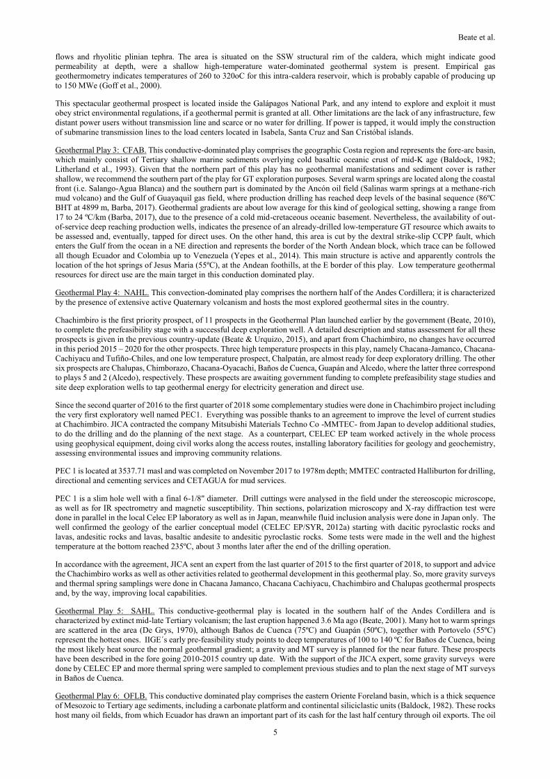
geothermal country update of ecuador: 2015-2020 · cordillera real, which are sub-linear nne...
TRANSCRIPT

Proceedings World Geothermal Congress 2020
Reykjavik, Iceland, April 26 – May 2, 2020
1
Geothermal Country Update of Ecuador: 2015-2020
Bernardo Beate, Matilde Urquizo & Andrés Lloret
Escuela Politécnica Nacional (EPN) – Dpto. de Geología, Ladrón de Guevara E11-253 y Andalucía, Quito/Ecuador.
Corporación Eléctrica del Ecuador (CELEC EP), Av. 6 de Diciembre N26- 235 y Orellana, Quito/Ecuador.
Instituto de Investigación Geológico Energético (IIGE) - Dirección de Gestión Científica, Av. De la República E7-263 y Diego de
Almagro, Quito/Ecuador.
[email protected], [email protected], [email protected]
Keywords: Ecuador, geothermal plays, prefeasibility studies, deep exploratory drilling, use of geothermal energy, Ground Source
Heat Pumps.
ABSTRACT
The groundbreaking geothermal event in this period 2015 – 2020 was the drilling of the first deep exploration well in the history of
Ecuador in Nov. 2017 in the Chachimbiro prospect. The well, located at an elevation of 3460masl reached a depth of 1978m with a
BHT of 235 °C, and was drilled with the help of non-reimbursable funding and technical cooperation of JICA to CELEC. A follow
up 2nd stage, to be funded by a government to government loan through JICA is envisioned for drilling 5 additional appraisal wells
and for the installation of a 5MWe wellhead unit, both to be tendered by CELEC under JICA regulations; positive results would aim
for a 50 MW power plant.
Chachimbiro is the first priority prospect, of 11 prospects in the Geothermal Plan launched by the government in 2010, to complete
the prefeasibility stage with a successful deep exploration well. Three high temperature prospects, namely Chacana-Jamanco,
Chacana-Cachiyacu and Tufiño-Chiles, and one low temperature prospect, Chalpatán, are almost ready for deep exploratory drilling.
The other six prospects are Chalupas, Guapán, Chimborazo, Chacana-Oyacachi, Baños de Cuenca and Alcedo, which are awaiting
government funding to complete prefeasibility stage studies and site deep exploration wells to tap geothermal energy for electricity
generation and direct uses.
On the other hand, CELEC has installed a state of the art laboratory for water and gas analysis for geothermal exploration and
purchased equipment for Grav-Mag- MT surveys and rock studies; it also has been very keen on capacity building by sending staff
members to overseas training programs in Japan, Iceland, El Salvador and Costa Rica.
Utilization of geothermal energy is still restricted to direct uses in swimming pools (5.16 MWt and 102.4 TJ/yr for annual utilization).
Nevertheless, the IIGE, which is in charge of the development of low temperature geothermal resources, has started the construction
of the first greenhouse powered by GSHP with horizontal ground loop. The IIGE also launched the study of the use of low to medium
temperature geothermal resources in the country energy mix. The expected outcome of this study should be the Geothermal Resource
Map, which will be done with the technical support of CEGA in the framework of the government to government agreement with
Chile. IIGE future developments include the study for a geothermal desalination plant in Galápagos as well as geothermal heating
using PCR (phase change materials) for urban and rural buildings.
Taking into account the tectonic setting of the Ecuadorean territory, including the 200 miles of ocean surrounding the Galapagos
Archipelago and covering the front of the mainland coast, six geothermal plays are proposed as to locate and consider geothermal
potential (theoretical): 1.Galápagos Rift, 2.Galápagos Hot Spot, 3.Northern Andes, 4.Southern Andes, 5.Coastal Fore-arc basin, and
6. Oriente Foreland basin.
Government policies, according to the Master Plan for Electricity, aim to develop renewable resources, including geothermal, to
substantially lessen the use of fossil fuels. The current energy mix is dominated by hydro (62.58%), fossil fuels (35.06%) and other
(2.37%) with a total installed generation capacity of 8059.28 MWe. The gross energy production is 29353.28 GWh/yr (as of Jan.
2019), where 21382.42 GWh are from renewables and 7971.49 GWh are from fossil fuels.
Finally, geothermal energy utilization in Ecuador is challenged to be cost-efficient in light of an abundant hydro resource, as well as
to be environmentally safe and socially accepted.
1. INTRODUCTION
This paper is a follow up of the country update for the previous interval (Beate & Urquizo, 2015). It summarizes geothermal activities
in Ecuador for the period 2015-2020. Nevertheless, the history of exploration before 2015 and the description of explored and under-
explored areas or prospects hasn’t been included in this summary, since no substantial changes have occurred in this last period, apart
from the Chachimbiro deep exploration drilling; in this case, the reader is kindly referred to the previous country updates (Beate and
Salgado, 2010 and Beate and Urquizo, 2015) and to the references therein.
Ecuador is a democratic republic, located on the equatorial pacific margin of Western South America; it has 17 million inhabitants
(INEC, 2019) living in a territory of 256,370 km2 (IGM, 2019); the official language is Spanish and the GNP was 108 398 MUSD
for the year 2018 (BCE, 2019).

Beate et al.
2
Since the approval of the new Constitution in 2008, the government has steered towards a stronger participation of the state in
exploration and development of the country’s energy and mineral resources. It is the aim of the government to change the energy
matrix towards the substitution of the fossil fuels for power generation with indigenous, clean, renewable energy resources, mainly
hydro, but also including wind, solar, geothermal and biomass.
The leading agencies for geothermal energy are MERNNR (Ministry for Energy and Non-Renewable Resources), CELEC EP (Public
Corporation for Electricity Generation and Transmission) and IIGE (Institute for Geological and Energy Research), SENAGUA
(National Secretariat for Water) and MAE (Ministry of the Environment).
Public funding has been allocated for geothermal exploration to both high and low temperature resources. In accordance to the
Constitution, which dictates that the State will be responsible to provide and regulate public services such as electricity, energy
concessions can be granted by exception through private finance initiatives (i.e. public auctions), private investment or joint ventures
with public companies where the State of Ecuador owns at least 51 % interest, but final adjustments for geothermal regulations are
still pending.
The following pages include an overview of Ecuador’s geological setting, a listing of geothermal resources and potential, together
with the state of geothermal utilization and a discussion of the actual and future development.
2. OVERVIEW OF ECUADOR´S GEOLOGICAL SETTING
Mainland Ecuador, located at the pacific equatorial margin of western South America, consists of three geographically and geo-
morphologically distinct regions: the coastal plains or Costa to the W, the Andes high mountain chain or Sierra in the center and the
upper Amazon basin or Oriente flatlands to the East. A fourth region comprises the Galapagos Archipelago, roughly located about
1000 km W of mainland Ecuador, in the Pacific Ocean (Fig.1)
Figure 1. Geodynamic setting of Ecuador and its Geothermal Plays. Redrawn after The Global Multi-Resolution Topography
(GMRT) Synthesis (Ryan, W.B.F. et al., 2009) and Maritime limits of Ecuador-IOA (2011) and modified from Bernard and
Andrade (2011), Spikings et al., (2001) and Gutscher et al., (1999).
The Andes are the backbone of the country. They consist of two parallel NNE striking mountain chains: a) the Eastern Cordillera or
Cordillera Real, which are sub-linear NNE striking belts of juxtaposed metamorphic rocks of mainly Paleozoic age, intruded by both,
S and I – type batholiths of early – mid Mesozoic age; and, b) the Western Cordillera or Cordillera Occidental, which core consists
of oceanic lithosphere with a Mid-Cretaceous basaltic plateau on top, accreted towards the continent in late Cretaceous; further
Paleocene volcanics and volcaniclastic material was added in now folded and faulted sequences; these rocks are intruded by Neogene
I-type granitoids (Litherland et al., 1993; Vallejo, 2007). Both cordilleras have been uplifted and are capped by mid- to late Tertiary
volcanics. Between the two Cordilleras, the Interandean Valley developed; it is laterally bonded by active faults, mainly thrust faults,
Beate et al.
3
and consists of thick late Tertiary to Recent volcaniclastic and epiclastic sedimentary sequences. Covering both Cordilleras and the
Interandean Valley in the Northern half of the Sierra, a broad, well developed, cal-alkaline volcanic arc extends northwards into
Colombia (Barberi et al., 1988; Hall & Beate, 1991). This continental arc is of Quaternary age and consists of more than 80 volcanoes,
of which at least 20 have been active in the Holocene (Hall et al., 2008) and two are currently in eruption. The Southern half of the
Sierra shows extensive, Oligo-Miocene explosive volcanism, but now extinct, due to the flattening of the slab since late Miocene
(Gutscher et al., 2000).
The Costa is the flat region west of the Andes; it comprises a late Cretaceous to Cenozoic fore –arc basin underlain by cold early
Cretaceous, oceanic crust; no active volcanism is present in this region (Litherland et al., 1993).
The Oriente is an extensive sedimentary basin, which overlies cratonic basement (Baldock, 1982). Older rocks include Jurassic
batholiths and a Cretaceous carbonate platform, covered by Tertiary epiclastic sediments. Along the cordilleran foothills, large thrust
faults cut the sequence with a NS strike. Quaternary alkaline volcanoes are present along the western margin of the basin in a back
arc setting (Hall et al., 2008). Mid-to Late Cretaceous intraplate basaltic volcanism affected the central part of the basin (Barragan
& Baby, 2014)
The Galapagos Archipelago, together with the aseismic submarine Carnegie ridge, represents the Galapagos Hot Spot (GHS) trace
above the Nazca Plate. The islands consist of about fifteen Quaternary basaltic shield volcanoes, increasing in age towards the East.
Just N of the Islands, the Galapagos spreading center (GSC) follows a EW strike and it is off set by the 91ºW transform (Fig. 1).
Geodynamic processes are controlled since late Oligocene by the nearly orthogonal convergence between Nazca and South American
plates, which has generated regional uplift and crustal faulting and deformation, as well as extensive volcanism (Lonsdale, 1978).
The western and northern part of the country constitutes the North Andean Block, which moves in a NE direction along the dextral
strike slip CCPP fault (Yepes et al., 2016; Vaca et al., 2019).
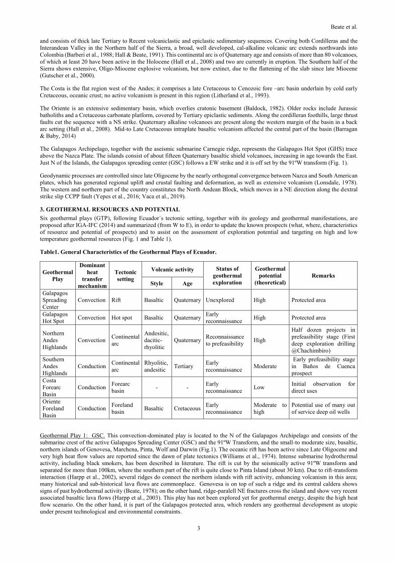
3. GEOTHERMAL RESOURCES AND POTENTIAL
Six geothermal plays (GTP), following Ecuador´s tectonic setting, together with its geology and geothermal manifestations, are
proposed after IGA-IFC (2014) and summarized (from W to E), in order to update the known prospects (what, where, characteristics
of resource and potential of prospects) and to assist on the assessment of exploration potential and targeting on high and low
temperature geothermal resources (Fig. 1 and Table 1).
Table1. General Characteristics of the Geothermal Plays of Ecuador.
Geothermal
Play
Dominant
heat
transfer
mechanism
Tectonic
setting
Volcanic activity Status of
geothermal
exploration
Geothermal
potential
(theoretical)
Remarks
Style Age
Galapagos
Spreading
Center
Convection Rift Basaltic Quaternary Unexplored High Protected area
Galapagos
Hot Spot Convection Hot spot Basaltic Quaternary
Early
reconnaissance High Protected area
Northern
Andes
Highlands
Convection Continental
arc
Andesitic,
dacitic-
rhyolitic
Quaternary Reconnaissance
to prefeasibility High
Half dozen projects in
prefeasibility stage (First
deep exploration drilling
@Chachimbiro)
Southern
Andes
Highlands
Conduction Continental
arc
Rhyolitic,
andesitic Tertiary
Early
reconnaissance Moderate
Early prefeasibility stage
in Baños de Cuenca
prospect
Costa
Forearc
Basin
Conduction Forearc
basin - -
Early
reconnaissance Low
Initial observation for
direct uses
Oriente
Foreland
Basin
Conduction Foreland
basin Basaltic Cretaceous
Early
reconnaissance
Moderate to
high
Potential use of many out
of service deep oil wells
Geothermal Play 1: GSC. This convection-dominated play is located to the N of the Galapagos Archipelago and consists of the
submarine crest of the active Galapagos Spreading Center (GSC) and the 91ºW Transform, and the small-to moderate size, basaltic,
northern islands of Genovesa, Marchena, Pinta, Wolf and Darwin (Fig.1). The oceanic rift has been active since Late Oligocene and
very high heat flow values are reported since the dawn of plate tectonics (Williams et al., 1974). Intense submarine hydrothermal
activity, including black smokers, has been described in literature. The rift is cut by the seismically active 91ºW transform and
separated for more than 100km, where the southern part of the rift is quite close to Pinta Island (about 30 km). Due to rift-transform
interaction (Harpp et al., 2002), several ridges do connect the northern islands with rift activity, enhancing volcanism in this area;
many historical and sub-historical lava flows are commonplace. Genovesa is on top of such a ridge and its central caldera shows
signs of past hydrothermal activity (Beate, 1978); on the other hand, ridge-paralell NE fractures cross the island and show very recent
associated basaltic lava flows (Harpp et al., 2003). This play has not been explored yet for geothermal energy, despite the high heat
flow scenario. On the other hand, it is part of the Galapagos protected area, which renders any geothermal development as utopic
under present technological and environmental constraints.

Beate et al.
4
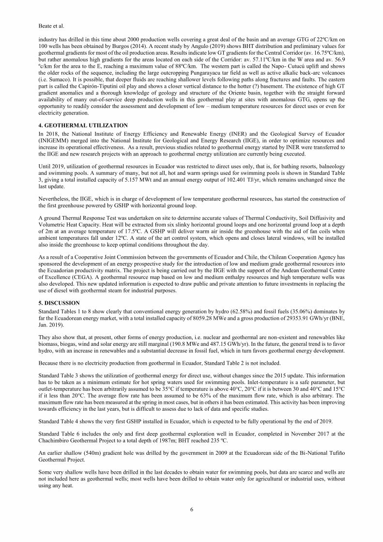
Figure 2. Geothermal Plays showing location and exploration stage of Geothermal Prospects in mainland Ecuador. Modified
from Vaca et al., (2019); Beate and Urquizo (2015) and Baby et al., (2013).
Geothermal Play 2: GHS. This convection-dominated play comprises the central part of the Galapagos Platform, which has been
constructed by the Galapagos Hot Spot (GHS) on top of the East- drifting lithospheric Nazca Plate. The majority of the 15 islands
are constructed by basaltic shield volcanoes with central calderas of Quaternary age (Harpp and Geist, 2018). Most of the recent and
current volcanic activity is located in the bigger western islands, which are closest to the hot spot up-flow. The central and eastern
islands show a general eastwards increase in age due to the drift of the Nazca plate, nevertheless, many of these islands also show
signs of recent volcanic activity. This is due to plume-rift-asthenosphere interactions along time. This play has not yet been explored
for geothermal resources, despite the high theoretical potential due to massive volcanism and high regional heat flow, mainly for
strict environmental and conservation policies, since Galapagos is a National Park.
Only one geothermal prospect is known until now from volcanological studies. It is located on Isabela Island inside the collapse
caldera of Alcedo shield volcano. It shows extensive hydrothermal alteration, numerous explosion craters (at least seven), strong
geothermal fumaroles discharging vapor at 97°C (locally superheated at 130ºC) and a heat source related to a primary basaltic origin
but also to shallow rhyolitic intrusions associated with explosive silicic volcanism of recent age (c.a. 120 ka, Geist, 1994) like obsidian
Beate et al.
5
flows and rhyolitic plinian tephra. The area is situated on the SSW structural rim of the caldera, which might indicate good
permeability at depth, were a shallow high-temperature water-dominated geothermal system is present. Empirical gas
geothermometry indicates temperatures of 260 to 320oC for this intra-caldera reservoir, which is probably capable of producing up
to 150 MWe (Goff et al., 2000).
This spectacular geothermal prospect is located inside the Galápagos National Park, and any intend to explore and exploit it must
obey strict environmental regulations, if a geothermal permit is granted at all. Other limitations are the lack of any infrastructure, few
distant power users without transmission line and scarce or no water for drilling. If power is tapped, it would imply the construction
of submarine transmission lines to the load centers located in Isabela, Santa Cruz and San Cristóbal islands.
Geothermal Play 3: CFAB. This conductive-dominated play comprises the geographic Costa region and represents the fore-arc basin,
which mainly consist of Tertiary shallow marine sediments overlying cold basaltic oceanic crust of mid-K age (Baldock, 1982;
Litherland et al., 1993). Given that the northern part of this play has no geothermal manifestations and sediment cover is rather
shallow, we recommend the southern part of the play for GT exploration purposes. Several warm springs are located along the coastal
front (i.e. Salango-Agua Blanca) and the southern part is dominated by the Ancón oil field (Salinas warm springs at a methane-rich
mud volcano) and the Gulf of Guayaquil gas field, where production drilling has reached deep levels of the basinal sequence (86ºC
BHT at 4899 m, Barba, 2017). Geothermal gradients are about low average for this kind of geological setting, showing a range from
17 to 24 ºC/km (Barba, 2017), due to the presence of a cold mid-cretaceous oceanic basement. Nevertheless, the availability of out-
of-service deep reaching production wells, indicates the presence of an already-drilled low-temperature GT resource which awaits to
be assessed and, eventually, tapped for direct uses. On the other hand, this area is cut by the dextral strike-slip CCPP fault, which
enters the Gulf from the ocean in a NE direction and represents the border of the North Andean block, which trace can be followed
all though Ecuador and Colombia up to Venezuela (Yepes et al., 2014). This main structure is active and apparently controls the
location of the hot springs of Jesus Maria (55ºC), at the Andean foothills, at the E border of this play. Low temperature geothermal
resources for direct use are the main target in this conduction dominated play.
Geothermal Play 4: NAHL. This convection-dominated play comprises the northern half of the Andes Cordillera; it is characterized
by the presence of extensive active Quaternary volcanism and hosts the most explored geothermal sites in the country.
Chachimbiro is the first priority prospect, of 11 prospects in the Geothermal Plan launched earlier by the government (Beate, 2010),
to complete the prefeasibility stage with a successful deep exploration well. A detailed description and status assessment for all these
prospects is given in the previous country-update (Beate & Urquizo, 2015), and apart from Chachimbiro, no changes have occurred
in this period 2015 – 2020 for the other prospects. Three high temperature prospects in this play, namely Chacana-Jamanco, Chacana-
Cachiyacu and Tufiño-Chiles, and one low temperature prospect, Chalpatán, are almost ready for deep exploratory drilling. The other
six prospects are Chalupas, Chimborazo, Chacana-Oyacachi, Baños de Cuenca, Guapán and Alcedo, where the latter three correspond
to plays 5 and 2 (Alcedo), respectively. These prospects are awaiting government funding to complete prefeasibility stage studies and
site deep exploration wells to tap geothermal energy for electricity generation and direct use.
Since the second quarter of 2016 to the first quarter of 2018 some complementary studies were done in Chachimbiro project including
the very first exploratory well named PEC1. Everything was possible thanks to an agreement to improve the level of current studies
at Chachimbiro. JICA contracted the company Mitsubishi Materials Techno Co -MMTEC- from Japan to develop additional studies,
to do the drilling and do the planning of the next stage. As a counterpart, CELEC EP team worked actively in the whole process
using geophysical equipment, doing civil works along the access routes, installing laboratory facilities for geology and geochemistry,
assessing environmental issues and improving community relations.
PEC 1 is located at 3537.71 masl and was completed on November 2017 to 1978m depth; MMTEC contracted Halliburton for drilling,
directional and cementing services and CETAGUA for mud services.
PEC 1 is a slim hole well with a final 6-1/8" diameter. Drill cuttings were analysed in the field under the stereoscopic microscope,
as well as for IR spectrometry and magnetic susceptibility. Thin sections, polarization microscopy and X-ray diffraction test were
done in parallel in the local Celec EP laboratory as well as in Japan, meanwhile fluid inclusion analysis were done in Japan only. The
well confirmed the geology of the earlier conceptual model (CELEC EP/SYR, 2012a) starting with dacitic pyroclastic rocks and
lavas, andesitic rocks and lavas, basaltic andesite to andesitic pyroclastic rocks. Some tests were made in the well and the highest
temperature at the bottom reached 235ºC, about 3 months later after the end of the drilling operation.
In accordance with the agreement, JICA sent an expert from the last quarter of 2015 to the first quarter of 2018, to support and advice
the Chachimbiro works as well as other activities related to geothermal development in this geothermal play. So, more gravity surveys
and thermal spring samplings were done in Chacana Jamanco, Chacana Cachiyacu, Chachimbiro and Chalupas geothermal prospects
and, by the way, improving local capabilities.
Geothermal Play 5: SAHL. This conductive-geothermal play is located in the southern half of the Andes Cordillera and is
characterized by extinct mid-late Tertiary volcanism; the last eruption happened 3.6 Ma ago (Beate, 2001). Many hot to warm springs
are scattered in the area (De Grys, 1970), although Baños de Cuenca (75ºC) and Guapán (50ºC), together with Portovelo (55ºC)
represent the hottest ones. IIGE´s early pre-feasibility study points to deep temperatures of 100 to 140 ºC for Baños de Cuenca, being
the most likely heat source the normal geothermal gradient; a gravity and MT survey is planned for the near future. These prospects
have been described in the fore going 2010-2015 country up date. With the support of the JICA expert, some gravity surveys were
done by CELEC EP and more thermal spring were sampled to complement previous studies and to plan the next stage of MT surveys
in Baños de Cuenca.
Geothermal Play 6: OFLB. This conductive dominated play comprises the eastern Oriente Foreland basin, which is a thick sequence
of Mesozoic to Tertiary age sediments, including a carbonate platform and continental siliciclastic units (Baldock, 1982). These rocks
host many oil fields, from which Ecuador has drawn an important part of its cash for the last half century through oil exports. The oil
Beate et al.
6
industry has drilled in this time about 2000 production wells covering a great deal of the basin and an average GTG of 22ºC/km on
100 wells has been obtained by Burgos (2014). A recent study by Angulo (2019) shows BHT distribution and preliminary values for
geothermal gradients for most of the oil production areas. Results indicate low GT gradients for the Central Corridor (av. 16.75ºC/km),
but rather anomalous high gradients for the areas located on each side of the Corridor: av. 57.11ºC/km in the W area and av. 56.9
ºc/km for the area to the E, reaching a maximum value of 88ºC/km. The western part is called the Napo- Cutucú uplift and shows
the older rocks of the sequence, including the large outcropping Pungarayacu tar field as well as active alkalic back-arc volcanoes
(i.e. Sumaco). It is possible, that deeper fluids are reaching shallower levels following paths along fractures and faults. The eastern
part is called the Capirón-Tiputini oil play and shows a closer vertical distance to the hotter (?) basement. The existence of high GT
gradient anomalies and a thorough knowledge of geology and structure of the Oriente basin, together with the straight forward
availability of many out-of-service deep production wells in this geothermal play at sites with anomalous GTG, opens up the
opportunity to readily consider the assessment and development of low – medium temperature resources for direct uses or even for
electricity generation.
4. GEOTHERMAL UTILIZATION
In 2018, the National Institute of Energy Efficiency and Renewable Energy (INER) and the Geological Survey of Ecuador
(INIGEMM) merged into the National Institute for Geological and Energy Research (IIGE), in order to optimize resources and
increase its operational effectiveness. As a result, previous studies related to geothermal energy started by INER were transferred to
the IIGE and new research projects with an approach to geothermal energy utilization are currently being executed.
Until 2019, utilization of geothermal resources in Ecuador was restricted to direct uses only, that is, for bathing resorts, balneology
and swimming pools. A summary of many, but not all, hot and warm springs used for swimming pools is shown in Standard Table
3, giving a total installed capacity of 5.157 MWt and an annual energy output of 102.401 TJ/yr, which remains unchanged since the
last update.
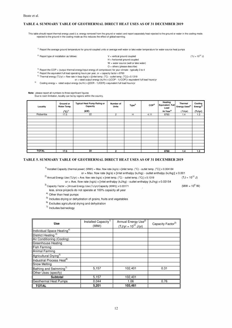
Nevertheless, the IIGE, which is in charge of development of low temperature geothermal resources, has started the construction of
the first greenhouse powered by GSHP with horizontal ground loop.
A ground Thermal Response Test was undertaken on site to determine accurate values of Thermal Conductivity, Soil Diffusivity and
Volumetric Heat Capacity. Heat will be extracted from six slinky horizontal ground loops and one horizontal ground loop at a depth
of 2m at an average temperature of 17.5ºC. A GSHP will deliver warm air inside the greenhouse with the aid of fan coils when
ambient temperatures fall under 12ºC. A state of the art control system, which opens and closes lateral windows, will be installed
also inside the greenhouse to keep optimal conditions throughout the day.
As a result of a Cooperative Joint Commission between the governments of Ecuador and Chile, the Chilean Cooperation Agency has
sponsored the development of an energy prospective study for the introduction of low and medium grade geothermal resources into
the Ecuadorian productivity matrix. The project is being carried out by the IIGE with the support of the Andean Geothermal Centre
of Excellence (CEGA). A geothermal resource map based on low and medium enthalpy resources and high temperature wells was
also developed. This new updated information is expected to draw public and private attention to future investments in replacing the
use of diesel with geothermal steam for industrial purposes.
5. DISCUSSION
Standard Tables 1 to 8 show clearly that conventional energy generation by hydro (62.58%) and fossil fuels (35.06%) dominates by
far the Ecuadorean energy market, with a total installed capacity of 8059.28 MWe and a gross production of 29353.91 GWh/yr (BNE,
Jan. 2019).
They also show that, at present, other forms of energy production, i.e. nuclear and geothermal are non-existent and renewables like
biomass, biogas, wind and solar energy are still marginal (190.8 MWe and 487.15 GWh/yr). In the future, the general trend is to favor
hydro, with an increase in renewables and a substantial decrease in fossil fuel, which in turn favors geothermal energy development.
Because there is no electricity production from geothermal in Ecuador, Standard Table 2 is not included.
Standard Table 3 shows the utilization of geothermal energy for direct use, without changes since the 2015 update. This information
has to be taken as a minimum estimate for hot spring waters used for swimming pools. Inlet-temperature is a safe parameter, but
outlet-temperature has been arbitrarily assumed to be 35°C if temperature is above 40°C, 20°C if it is between 30 and 40°C and 15°C
if it less than 20°C. The average flow rate has been assumed to be 63% of the maximum flow rate, which is also arbitrary. The
maximum flow rate has been measured at the spring in most cases, but in others it has been estimated. This activity has been improving
towards efficiency in the last years, but is difficult to assess due to lack of data and specific studies.
Standard Table 4 shows the very first GSHP installed in Ecuador, which is expected to be fully operational by the end of 2019.
Standard Table 6 includes the only and first deep geothermal exploration well in Ecuador, completed in November 2017 at the
Chachimbiro Geothermal Project to a total depth of 1987m; BHT reached 235 ºC.
An earlier shallow (540m) gradient hole was drilled by the government in 2009 at the Ecuadorean side of the Bi-National Tufiño
Geothermal Project.
Some very shallow wells have been drilled in the last decades to obtain water for swimming pools, but data are scarce and wells are
not included here as geothermal wells; most wells have been drilled to obtain water only for agricultural or industrial uses, without
using any heat.

Beate et al.
7
Allocated professional personnel to geothermal activities (Standard Table 7) has increased substantially in the first half of this period,
mainly from the side of the government with CELEC EP and INER/IIGE and less so with MERNNR and universities in Quito (EPN
and Yachay Tec), although it diminished strongly in the second half due to government funding restrictions; there is no professional
geothermal personnel employed by the private industry.
Foreign Aid Programs are turning into reality with participation of JICA to CELEC EP and CEGA/CHILE with IIGE. The Geological
Survey of Ecuador is now part of IIGE and is re-starting ground-level geothermal exploration in the country.
Standard Table 8 shows that public investment has been allocated to geothermal activities in this last five year term (2015 to 2020)
in the amount of 15 MUSD for research of the Chachimbiro geothermal project, including the drilling of one deep exploration hole.
This has been possible due to the positive political decision of the present administration to explore and develop the geothermal
resources in Ecuador and with the straight forward participation of JICA/government of Japan.
General policies and planning regarding electrical energy are issued by the government through the MERNNR (Ministry of Energy
and Non-Renewable Resources). The MERNNR coordinates the electric energy issues with ARCONEL, which is in charge of the
regulation of the sector, its electrification master plan, of supervising power generation projects, concessions/contracts for power
generation, prices and environmental issues. One of the problems in the electricity market is the availability of energy, rather than
the installed capacity, since the reservoirs for hydro generation are in some cases small and fossil fuels are expensive and not always
at hand. This situation favors the demand of geothermal power as base load. The problem was temporarily solved by importing energy
from Colombia and Peru, but this tendency has reversed in the last 2 years, with the commissioning of the new hydro projects.
Any project to generate electricity, including geothermal, needs a permit issued by ARCONEL, which in turn demands a water-use
permit from SENAGUA (National Agency for Water Issues) and an environmental permit from the Ministry of the Environment
(MAE). According to the current constitutional law, energy in any form belongs to the state and its exploration and development is
strictly regulated by the government, since energy is a strategic issue.
6. FUTURE DEVELOPMENT AND INSTALLATIONS
The next immediate step towards geothermal electricity generation in Ecuador is the field development of the Chachimbiro project
through an ODA loan from JICA to CELEC EP. This phase is planned to start soon and involves the drilling of 5 appraisal wells and
the installation of a 5MW well-head power plant with a budget of around 65 MUSD. This project will push forward other geothermal
proposals as well as give experience to local staff and local companies, and create new opportunities for surrounding communities
and academia.
Also, in parallel, JICA, probably in coordination with other multilaterals, is going to support the making of the specific terms of
regulation and applicable model for the feasibility to bring in more investment to develop additional geothermal projects. At the same
time, dissemination campaigns are going to take place to inform society, authorities and politicians about the benefits of each stage
of geothermal development and pointing out the necessity to complement the current electrical matrix, which consists mainly of
hydroelectricity, to cope with yearly worsening dry seasons.
An inter-institutional cooperation at government levels is planned in order to efficiently share resources like lab facilities and geo-
scientific staff, in order to build core capabilities for a continuous development of geothermal resources
Many efforts have been made by the government of Ecuador to eliminate the use of fossil fuels in the Galapagos Islands in the short
term. Although a promising geothermal field exists on Isabela Island´s Alcedo volcano as already mentioned in GT play 2, it is
located far away from the nearest town and within a protected natural area. Therefore, electricity generation from geothermal
resources seems unlikely for now. Direct uses on the other hand are a much more plausible option. A proposal for a geothermal
energy-driven desalination plant has been handed out to local authorities for further consideration (Lloret A, 2015). Presently, the
project has been submitted for national and international grant funding to finance reconnaissance studies aimed to increase the
prospect´s geo-scientific data.
In November 2018, Ecuador became a member of the Ibero-American Shallow Geothermal Network. Among other research activities
related to the development of low and medium grade geothermal sources, the government, through the IIGE, will promote the
deployment of ground source heat pumps using phase change materials (PCM) for thermal conditioning of buildings of different
types, both in urban, rural and industrial environments, with the use of proven and available Ibero-American technologies.
IIGE has resumed exploration of geothermal prospects in the country with special attention in low and medium enthalpy resources.
Gas and water samples are being collected, and geophysical studies, which include resistivity and magnetotelluric surveys, are also
expected to be carried out. The main purpose is to update and reassess the information obtained in previous studies and monitor
changes in geothermal systems that are already known. Similarly, weather stations have been placed in close range from known
geothermal prospects to study hydrological changes that may influence the development of geothermal projects in the future. Finally,
geological and geochemical mapping is also being carried out in underexplored locations were locals have reported geothermal
activity.
Several regions in the country remain unexplored for geothermal resources, namely the sedimentary basins in the Costa, the back-arc
volcanic chain with recently active alkalic volcanoes and the sedimentary foreland basin in the Oriente, as well as the Galapagos
Archipelago at both, the hot spot and the nearby spreading center. This increases the exploration potential for geothermal resources
in the country, in addition to the follow up exploration of the prospects cited above. Application of actual and future technology will
allow to tap hidden resources, those where geothermal evidence at surface is nil (Duffield and Sass, 2003) and consider EGS targets
as well.
Beate et al.
8
A good start will be to produce both, the heat flow map and the geothermal map of Ecuador with updated data. In this regard, IIGE
is keen to work on the Geothermal Atlas of Ecuador in the following years. It is imperative to get the necessary funding (public and
private) to drill the most promising prospects and tap geothermal power in Ecuador.
And Chachimbiro Geothermal Project, with its first 2000m deep exploratory well, is a promising enterprise in the right direction,
with CELEC EP as a clear and strong leader.
7. CONCLUSIONS
Ecuador is keen to continue to explore and, consequently, aims to develop its geothermal resources in all its territory, for both
electricity generation and direct uses, to increase renewable energy production and to lessen the use of fossil fuels. The leading
government agencies for geothermal energy are CELEC EP for generation and IIGE for exploration, research and development of
direct uses; both agencies are part of the Ministry of Energy and Non-Renewable Resources and follow the Master Plan for Energy
Development.
The Ecuadorean sovereign territory comprises six geothermal plays, namely: Galápagos Hotspot, Galápagos Spreading Center,
Northern Sierra with Quaternary active volcanism, Southern Sierra with extinct Tertiary volcanism, Fore-arc Cenozoic sedimentary
basin and Fore-land Meso-Cenozoic sedimentary basin. The first three geothermal plays are convection-dominated and the latter are
conduction-dominated.
The most advanced exploration yet has taken place in the Northern Sierra Geothermal Play, where 1 prospect, Chachimbiro, has been
drilled to 1978m depth with the first-ever deep exploration well in Ecuador´s history, under the technical and financial assistance of
JICA to CELEC EP.
Results are encouraging for Chachimbiro (BHT 235ºC) and follow-up funding for appraisal drilling of 5 deep wells and for the
installation of one well-head generation unit has been already approved by the government under an ODA agreement with JICA for
about 72 MUSD, where 12 MUSD are committed by the Ecuadorean Government.
Other 4 prospects (Chacana-Cachiyacu, Chacana-Jamanco, Chalpatán and Tufiño), also in the Northern Sierra Geothermal Play, are
drill-ready for deep wells and cueing for funding; 3 others (Chalupas, Chacana-Oyacachi and Chimborazo) are at early exploration
stages. Two prospects in the Southern Sierra Geothermal Play (Baños de Cuenca and Guapán) are also in early exploration stages as
well as Alcedo, located in the Galapagos Hot Spot Geothermal Play. The other 3 Geothermal Plays, the Galápagos Spreading Center
and the two conduction-dominated sedimentary basins, remain unexplored for geothermal resources at present.
Until today, the only practical use of geothermal energy in Ecuador is in swimming pools. Nevertheless, the first GSHP has been
installed and is being tested for greenhouse applications under the guidance of IIGE. It is expected that results from this testing will
accelerate the use of GSHPs in residential and commercial sectors. And, in the near future (next 2 -3 years), we are going to see the
generation of electricity in Chachimbiro under the leadership of CELEC EP.
Ongoing conversations between the Government of Ecuador and multilateral finance and technical assistance agencies, such as JICA,
IDB and CAF, are taking place to re-take nation-wide surface geothermal exploration programs to define drilling targets, increase
capacity building and to prepare the regulations for a geothermal law, which should allow both, government and private investment
in geothermal energy.
8. ACKNOWLEDGMENTS
We acknowledge our thanks to Arq. Robert Simpson, General Manager of CELEC EP for allocating time and authorizing access to
data used in this paper. Ing. Carlos Pérez, minister of Energy and Non-Renewable Resources, is acknowledged for encouraging
geothermal exploration and development of renewable energy resources in Ecuador. Ing. Martin Cordovez, Executive Director of
IIEG, is acknowledged for sharing its plans on geothermal energy mentioned above. Also many thanks to Dr. Florinella Muñoz,
Director of EPN (Escuela Politécnica Nacional) and to Dr. Johnny Zambrano, Dean of the Faculty of Geological and Petroleum
Engineering at EPN for supporting the writing of this paper. Last but not least, many thanks to Elena Angulo for assisting with figures
and tables in digital format and editing. Nevertheless, the responsibility of this paper belongs to the authors.
REFERENCES
Almeida E., Sandoval, G., Panichi, C., Noto, P., Beilucci, L.: Modelo geotérmico preliminar de áreas volcánicas del Ecuador, a partir
de estudios químicos e isotópicos de manifestaciones termales. Geothermal Investigations with isotope and geochemical
techniques in Latin America. Proceedings of a final research Coordination Meeting. IAEA, Vienna-Austria (1992). 219-235 pp
Angulo, E. & Beate, B., 2019. Temperature Distribution and Zoning of the Geothermal Gradient in the Oriente Basin, Ecuador.
Abstract 8th ISAG Conference, EPN, Quito – Ecuador.
Aspden, J.A and Litherland, M.: The geology and Mesozoic collisional history of the Cordillera Real, Ecuador. Tectonophysics,
v.205, (1992) 187-204pp.
Baby, P., Rivadeneira, M., Barragán, R., Christophoul, F., (2013) thick-skinned tectonics in the Oriente foreland basin of Ecuador,
Geological Society, London, Special Publication, doi 10.1144/SP377.1
Baldock, M.W.: Geology of Ecuador, explanatory bulletin of the national geological map of the Republic of Ecuador 1 : 1000000
scale, DGGM-IGS, London (1982) 54pp.
Barba, D., 2017. Gradiente Geotermal de la Cuencas de Ante-Arco del Ecuador. VIII. Jornadas Ciencias de la Tierra, EPN. Quito.
5p.
Barberi, F. et al.: Plio-Quaternary Volcanism in Ecuador. Geology Magazine 125 (1), (1988), pp. 1 - 14.

Beate et al.
9
Barragán, R. & Baby, P., 2014. Magmatismo Alcalino Intra-placa en la Cuenca Cretácica Oriente, Ecuador: Evidencias Geoquímicas,
Geocronológicas y Tectónicas. In: La Cuenca Oriente, Geología y Petróleo. Baby, P., Rivadeneira, M. &Barragán, R., editors.
IFEA-IRD-Petroamazonas EP. Quito – Ecuador. pp 81 – 102.
Beate, B., 1978. Geología y Petrografía de la Isla Genovesa, Galápagos. Tesis de Grado en Ingeniería Geológica, (EPN), Quito-
Ecuador. 81p.
Beate, B. et al.: Mio-Pliocene adakite generation related to flat subduction in southern Ecuador: the Quimsacocha volcanic center.
EPSL 192 (2001) 561-570 pp.
Beate, B., and Salgado, R.: Geothermal Country Update for Ecuador, 2005 - 2010. Proceedings of the World Geothermal Congress,
Bali, Indonesia, (2010). 16 p.
Beate, B.: Plan para el Aprovechamiento de los Recursos Geotérmicos en el Ecuador. Unp.Tech.Report for MEER, Quito. (2010)165
p.
Beate, B. & Urquizo,M.: Geothermal Country Update for Ecuador, 2010 – 2015. Proceedings of the World Geothermal Congress,
Melbourne, Australia (2015).
Bernard and Andrade (2011). Volcanes Cuaternarios del Ecuador Continental. IG-EPN and IRD.
BCE, 2019: Central Bank of Ecuador, website: https://www.bce.fin.ec/index.php/informacioneconomica/ (in Spanish)
Bloomquist R.G. Prioritizing sites and determining environmental conflicts. IGA-WGC (1995) 29-41pp.
Burgos, J., Baby, P., Christophoul, F., Soula, J. C., Rochat, P. (2004). Cuantificación de las erosiones Terciarias y Plio-Cuaternarias
en la parte Sur de la Cuenca Oriente. In: La Cuenca Oriente: Geología y Petróleo, 1° edición. Travaux de I'Institut Francais
dÉtudes Andines, 144, 116-130.
CELEC EP/SYR.: Initial Prefeasibility Study to Develop a Conceptual Model for the Chachimbiro Geothermal Project.
Unp.Tech.Report prepared by SYR on behalf of CELEC EP. (Directors: T. Powell-Project; C. Klein-Geochemistry; W.
Cumming-Geophysics; G.Smith-En vironmental). Quito, Final Report (2012.a ) 121 p.
CELEC EP/SYR.: Initial Prefeasibility Study to Develop a Conceptual Model for the Chacana Geothermal Project. Unp.Tech.Report
prepared by SYR on behalf of CELEC EP. (Directors: B.Beate-Project, M.Hall-Geology, S.Inguaggiato- Geochemistry; E.
Anderson-Geophysics; G.Smith-Environmental). Quito. Final Report (2012.b).
De Grys, A. et al.: A Note on the Hot Springs of Ecuador. Geothermics (1970) 1400-1404pp.
Duffield, W., Sass J.: Geothermal Energy-Clean Power from the Earth’s Heat. USGS-Circular 1249 (2003).
Geist, D., Howard, K., Jellinek, MA & Rayder, S.: The volcanic history of Volcan Alcedo, Galapagos Archipelago: A case study of
rhyolitic oceanic volcanism. Bull. Volcanology. 56, 243 – 260, 1994
Goff, F., McMurtry, Counce, D., Stimac, J.A, Roldan-Manzo, A.R. & Hilton, D.R.: Contrasting hydrothermal activity at Sierra Negra
and Alcedo volcanoes, Galapagos Archipelago, Ecuador. Bull. Volcanology. (2000) 62: 34 – 52
Gutscher M.A., Malavieille, J., Lallemand, S., Collot, J. Y. (1999). Tectonic segmentation of the North Andean margin: impact of
the Carnegie Ridge collision. Earth and Planetary Science Letters, Volume 168, Issues 3-4, 255-270 pp.
Gutscher M.A., Olivet, D., Aslanian, J.P., Maury, R..: The “lost Inca Plateau”: cause of flat subduction beneath Peru? Earth Planet
(2000) 335-341pp.
Hall, M.L and Beate, B.: El Volcanismo Plio-cuaternario en los Andes del Ecuador. Est. Geogr. Vol 4. Corp. Edit.Nacional. Quito
(1991). pp. 5 - 17.
Hall, M., Samaniego, P., Le Pennec, J.L., Johnson, J.B.: Ecuadorian Andes volcanism: A review of Late Pliocene to present activity.
Journal of Volcanology and Geothermal Research 176 (2008), 1 - 6.
Harpp, K. & Geist, D., 2002. Wolf-Darwin Lineament and Plume Ridge Interaction in Northern Galapagos. G3 vol.3 Nº11. 19p
Harpp, K.S., Fornari, D.J., Geist, D.J. and Kurz, M.D., 2003. Genovesa Submarine Ridge: a Manifestation of Plume-Ridge Interaction
in the Nortern Galapagos Islands. G3 v.4 Nº9. 27p.
Harpp, K.S. & Geist, G.J., 2018. The Evolution of the Galapagos volcanoes: An Alternative Perspective. Frontiers in Science, V6
Article 50. 16p.
Hughes R. and Pilatasig L.: Cretaceous and Tertiary terrane accretion in the Cordillera Occidental of the Ecuadorian Andes.
Tectonophysics, 345 (2002), 29-48pp.
IGA-IFC, 2014. Best Practices Guide for Geothermal Exploration. IGA Service GmbH, Bochum, Germany. 194 p.
IGM, 2019: Ecuadoran Military Geographic Institute, website:
http://www.geoportaligm.gob.ec/portal/index.php/descargas/geoinformacion/ (in Spanish)
INEC, 2019: National Institute of Statistics and Censuses, website: http://www.ecuadorencifras.gob.ec/institucional/home/ (in
Spanish)
INER / SYR: Geological and Geochemical studies of the Baños de Cuenca Geothermal Prospect, (2014).
Inguaggiato, S., Hidalgo, S., Beate, B., Bourquin, J.: Geochemical and Isotopic characterization of Volcanic and Geothermal Fluids
discharged from the Ecuadorean Volcanic Arc. Geofluids, 10-4, (2010) pp 525-541.

Beate et al.
10
Litherland M., Zamora, A. and Egüez, A.: Mapa Geológico de la República del Ecuador 1:1’000.000. CODIGEM-BGS, Quito.
(1993).
Lloret, A.: Use of geothermal energy for seawater desalination in the Galápagos Islands. Geothermal Training Programme (2015),
27 pp
Londsdale, P.: Ecuadorian subduction system. AAPG 62 (1978) 2454-2477pp.
MEER/CELEC/INP/CGS: Prefeasibility Study of an Integral Geothermal Model of Chalpatán Caldera. Unp. Tech.Report prepared
by CGS on behalf of MEER-CELEC-INP. Director: J. Albert-Project. (2013).
SENPLADES 2017: National Development Plan 2017-2021. National Planning Council, Quito, Ecuador (in Spanish), 148pp
Spikings, R., Winkler, W., Seward, D. and Handler, R. (2001). Along-strike variations in the thermal and tectonic response of the
continental Ecuadorian Andes to the collision with heterogeneous oceanic crust., Earth and Planetary Science, Letters 5742, pp.
1-17.
Vaca, S., Vallée, M., Nocquet, J.-M., Alvarado, A., (2019) Active deformation in Ecuador enlightened by a new waveform-based
catalog of earthquake focal mechanisms, Journal of South American Earth Sciences (2019), doi:
https://doi.org/10.1016/j.jsames.2019.05.017.
Vallejo C (2007) Evolution of the Western Cordillera in the Andes of Ecuador (Late Cretaceous–Paleogene). Ph.D. thesis, ETH
Zürich, p 208
Williams, D.L., von Herzen, R.P., Sclater, J.G. and Anderson, R.N., 1974. The Galapagos Spreading Centre: Lithospheric Cooling
and Hydrothermal Circulation. Geophys. J. R. Astr. Soc. 38, p587 – 608.
Yepes,H., L. Audin, A. Alvarado, C. Beauval, J. Aguilar, Y. Font, and F. Cotton (2016), A new view for the geodynamics of Ecuador:
Implication in seismogenic Source definition and seismic hazard assessment, Tectonics, 35, doi:10.1002/2015TC003941.

Beate et al.
11
STANDART TABLES - NOTE: TABLE 2/8 IS NOT INCLUDED.
TABLE 1. PRESENT AND PLANNED PRODUCTION OF ELECTRICITY
Balance Nacional de Energía Enero 2019, https://www.regulacionelectrica.gob.ec/balance-nacional/
TABLE 3. UTILIZATION OF GEOTHERMAL ENERGY FOR DIRECT HEAT AS OF 31 DECEMBER 2019 (other than
heat pumps)
Capacity
MWe
Gross
Prod.
GWh/yr
Capacity
MWe
Gross
Prod.
GWh/yr
Capacity
MWe
Gross
Prod.
GWh/yr
Capacity
MWe
Gross
Prod.
GWh/yr
Capacity
MWe
Gross
Prod.
GWh/yr
Capacity
MWe
Gross
Prod.
GWh/yr
Capacity
MWe
Gross
Prod.
GWh/yr
Capacity
MWe
Gross
Prod.
GWh/yr
Capacity
MWe
Gross
Prod.
GWh/yr
In operation in
December 20190 0 2825.3 7971.49 5043.19 20834.70 0 0 21.15 82.69 6.504 45.29 136.4 381.67 26.738 38.07 8059.28 29353.91
Under construction in
December 20190 0 0 0 303 0 0 0 50 0 0 0 0 0 0 0 353.00 -
Funds committed but
not yer under
construction in
December 2019
0 5 0 0 0 0 0 0 100 0 0 0 0 0 200 0 300.00 5.00
Estimated total projected
use by 2020 - - 2955.26 8338.18 5043.19 21793.10 - - 22.12 86.50 6.80 47.37 142.67 399.23 27.97 39.82 8198.02 30704.19
Other
Renewables
(solar)
Total
Other
Renewables
(biomass)
Geothermal Fossil Fuels Hydro Nuclear
Other
Renewables
(wind)
Other
Renewables
(biogas)
TABLE 3. UTILIZATION OF GEOTHERMAL ENERGY FOR DIRECT HEAT AS OF 31 DECEMBER 2014 (other than heat pumps)
1)I = Industrial process heat
2)Enthalpy information is given only if there is steam or two-phase flow
3)Capacity (MWt) = Max. flow rate (kg/s)[inlet temp. (
oC) - outlet temp. (
oC)] x 0.004184
or = Max. flow rate (kg/s)[inlet enthalpy (kJ/kg) - outlet enthalpy (kJ/kg)] x 0.001
4)Energy use (TJ/yr) = Ave. flow rate (kg/s) x [inlet temp. (
oC) - outlet temp. (
oC)] x 0.1319
or = Ave. flow rate (kg/s) x [inlet enthalpy (kJ/kg) - outlet enthalpy (kJ/kg)] x 0.03154
5)Capacity factor = [Annual Energy Use (TJ/yr)/Capacity (MWt)] x 0.03171
Note: the capacity factor must be less than or equal to 1.00 and is usually less,
since projects do not operate at 100% of capacity all year.
Note: please report all numbers to three significant figures.
Capacity3)
Locality Type1)
Flow Rate Temperature (oC) Enthalpy
2) (kJ/kg) Ave. Flow Energy
4) Capacity
(kg/s) Inlet Outlet Inlet Outlet (MWt) (kg/s) (TJ/yr) Factor5)
Baños Cuenca B 8.000 73.000 35.000 1.272 5.040 25.261 0.629
Baños Tungurahua- Virgen B 5.120 53.000 35.000 0.386 3.226 7.659 0.629
El Salado B 5.000 44.300 35.000 0.195 3.150 3.864 0.628
Palictahua B 2.800 40.700 35.000 0.0067 1.764 1.326 0.627
Chachimbiro- Toma B 1.500 58.000 35.000 0.144 0.945 2.867 0.631
Pitzantzi B 0.950 40.800 35.000 0.023 0.599 0.458 0.631
Naugulvi B 2.000 52.000 35.000 0.142 1.260 2.825 0.631
Cununyacu- Chimborazo B 1.400 47.500 35.000 0.073 0.882 1.454 0.632
Guayllabamba- Chimborazo B 5.000 40.000 35.000 0.105 3.150 2.077 0.627
Ilaló- Cununyacu B 8.000 27.000 15.000 0.402 5.040 7.977 0.629
Tingo B 1.200 32.000 20.000 0.060 0.756 1.197 0.633
San Antonio B 12.000 35.500 20.000 0.778 7.560 15.456 0.630
Ushimana B 1.000 19.000 15.000 0.017 0.630 0.332 0.619
Chunchi B 2.000 29.500 15.000 0.121 1.260 2.410 0.632
Ilaló B 5.000 35.000 20.000 0.314 3.150 6.232 0.629
Papallacta- Termas B 1.100 53.000 35.000 0.083 0.693 1.645 0.628
El Tambo B 1.000 50.000 35.000 0.063 0.630 1.246 0.627
Jamanco B 2.000 66.000 35.000 0.259 1.260 5.152 0.631
Cachiyacu B 1.200 68.000 35.000 0.166 2.756 3.291 0.629
Portovelo- Río Amarillo B 1.200 57.000 35.000 0.110 0.756 2.194 0.632
Tufiño- Aguas Hed. B 3.000 53.000 35.000 0.226 1.890 4.487 0.630
San Vicente B 2.000 38.000 20.000 0.151 1.260 2.991 0.628
TOTAL 72.470 5.157 47.625 102.401
Maximum Utilization Annual Utilization
H = Individual space heating (other than heat pumps)
C = Air conditioning (cooling) D = District heating (other than heat pumps)
A = Agricultural drying (grain, fruit, vegetables) B = Bathing and swimming (including balneology)
F = Fish farming G = Greenhouse and soil heating
K = Animal farming O = Other (please specify by footnote)
S = Snow melting
(MW = 106 W)
(TJ = 1012
J)
Beate et al.
12
TABLE 4. SUMMARY TABLE OF GEOTHERMAL DIRECT HEAT USES AS OF 31 DECEMBER 2019
TABLE 5. SUMMARY TABLE OF GEOTHERMAL DIRECT HEAT USES AS OF 31 DECEMBER 2019

Beate et al.
13
TABLE 6. WELLS DRILLED FOR ELECTRICAL, DIRECT AND COMBINED USE OF GEOTHERMAL RESOURCES
FROM JANUARY 1, 2015 TO DECEMBER 31, 2019 (excluding heat pump wells)
1) Include thermal gradient wells, but no ones less than 100m deep.
The well reached 1978m deep, the first meter was drilled in august 2017 and the last one on november 2017 and the last temperature
registered in march 2018 was 235°C.
TABLE 7. ALLOCATION OF PROFESSIONAL PERSONNEL TO GEOTHERMAL ACTIVITIES (Restricted to personnel
with University degrees)
(1) Government
(2) Public Utilities
(3) Universities
(4) Paid Foreign Consultants
(5) Contribute Through Foreign Aid Program
(6) Private Industry
In 2016 complimentary geohysics, geochemistry and geology studies were done, some people from CELEC EP participate working
with the experts. In 2017, the first well was drilled and more people from the company was involved, helping in the logistics, health,
safety and environmental, learning in the rig, labs, and different services.
In 2018, planning activities were done and because of budget cuts some peopleo was fired from CELEC EP.
In 2019, people are working mainly to complete the Loan Agreement process, civil works and civil designs, monitoring and social
management.
TABEL 8. TOTAL INVESTMENTS IN GEOTHERMAL IN (2019) US$
Electric
PowerDirect Use Combined
Other
(specify)
Exploration (all) 1 1,987
Production >150 C
150-100 C
<100 C
Injection (all)
Total 1 1,987
Wellhead
TemperaturePurpose
Number of wells DrilledTotal Depth
(km)
( 1 ) ( 2 ) ( 3 ) ( 4 ) ( 5 ) ( 6 )
2015 3 9 1 --- 1 ---
2016 1 17 1 --- 11 ---
2017 1 18 1 --- 15 ---
2018 1 10 1 --- 8 ---
2019 4 6 1 --- 1 ---
Total 3 6 1 --- --- ---
YearProfessional Person - Years of Effort
Direct Electrical Private Public Cooperation
Millon US$ Million US$ Million US$ Million US$ % % %
1995 - 1999 ---- ---- ---- ---- ---- ---- ----
2000 - 2004 ---- ---- ---- ---- ---- ---- ----
2005 - 2009 0.37 ---- ---- ---- ---- 100% ----
2010 - 2014 7.2 ---- ---- ---- ---- 100% ----
2015 - 2019 15 ---- 0.23 ---- ---- 30% 70%
UtilizationResearch &
Deveopment Incl.
Field Development
Including ProductionPeriod
Funding Type