germany berlin tiergarten tunnel verkehrsanlagen im ... · this report was compiled by the german...
TRANSCRIPT
Germany
Berlin Tiergarten
Tunnel
Verkehrsanlagen im
zentralen Bereich –
VZB
2
This report was compiled by the German OMEGA Team, Free University Berlin, Berlin,
Germany.
Please Note: This Project Profile has been prepared as part of the ongoing OMEGA Centre
of Excellence work on Mega Urban Transport Projects. The information presented in the
Profile is essentially a 'work in progress' and will be updated/amended as necessary as work
proceeds. Readers are therefore advised to periodically check for any updates or revisions.
The Centre and its collaborators/partners have obtained data from sources believed to be
reliable and have made every reasonable effort to ensure its accuracy. However, the Centre
and its collaborators/partners cannot assume responsibility for errors and omissions in the
data nor in the documentation accompanying them.
3
CONTENTS
A PROJECT INTRODUCTION
Type of project
Project name
Description of mode type
Technical specification
Principal transport nodes
Major associated developments
Parent projects
Country/location Current status
B PROJECT BACKGROUND
Principal project objectives Key enabling mechanisms
Description of key enabling mechanisms
Key enabling mechanisms timeline Main organisations involved Planning and environmental regime
Outline of planning legislation
Environmental statements
Overview of public consultation
Ecological mitigation
Regeneration
Ways of appraisal
Complaints procedures
Land acquisition
C PRINCIPAL PROJECT CHARACTERISTICS
Detailed description of route Detailed description of main and intermediate travel nodes Project costs
Construction costs
Construction cost time line Project delivery Main engineering features
Details of engineering and construction
Details of main contracts
Main engineering key facts and figures

4
D PROJECT TIMELINE
Project timeline Project timeline key issues
E PROJECT FUNDING
Introduction Background to funding
Revenue
Prediction of funding costs
Funding key stages Traffic forecasts Funding sources Commentary on financing/funding
F OPERATIONS
Reported traffic volume How traffic forecasts were formulated
G BIBLIOGRAPHY
APPENDIX
GLOSSARY
5
List of figures
Figure 1: Entry of the car tunnel in the South near Landwehr Canal............................... 7
Figure 2: View into North-South railway tunnel tube constructed with tunnelling shield .............................................................................................................................................. 7
Figure 3: Northern tunnel entry city railway S21 ............................................................... 8
Figure 4: Construction works metro tunnel U55 ............................................................... 8
Figure 5: Railway axis Berlin – Verona/Milan – Bologna – Naples – Messina – Palermo .............................................................................................................................................10
Figure 6: Overview of the Tunnel ......................................................................................11
Figure 7: Main organisations involved in planning and construction of North-South Connection ........................................................................................................................17
Figure 8: Travel nodes along North-South railway connection ......................................27
Figure 9: Berlin Central Station under construction ........................................................28
Figure 10: Map of location of Berlin Central Station (see Hauptbahnhof) ......................28
Figure 11: Urban development plan Lehrter Sadtquartier around Central Station ........29
Figure 12: Urban development plan Humboldt Harbour ..................................................30
Figure 13: Local railway station at Potsdamer Platz ........................................................31
Figure 14: View onto Potsdamer Platz ..............................................................................33
Figure 15: Finance agreement for North-South railway connection between Federal Government and German Railways in EUR ......................................................................44
Figure 16: Aerial view of Southern Cross (Bahnhof Südkreuz) and surrounding area.. .............................................................................................................................................56
Figure 17: German Railways Service Store in a Pavilion on Gesundbrunnen station square .................................................................................................................................57
List of tables
Table 1: key enabling mechanisms timeline ....................................................................14
Table 2: Contractors working on North-South connection .............................................20
Table 3: Contractors working on road tunnel ...................................................................21
Table 4: Contractors working on metro tunnel ................................................................21
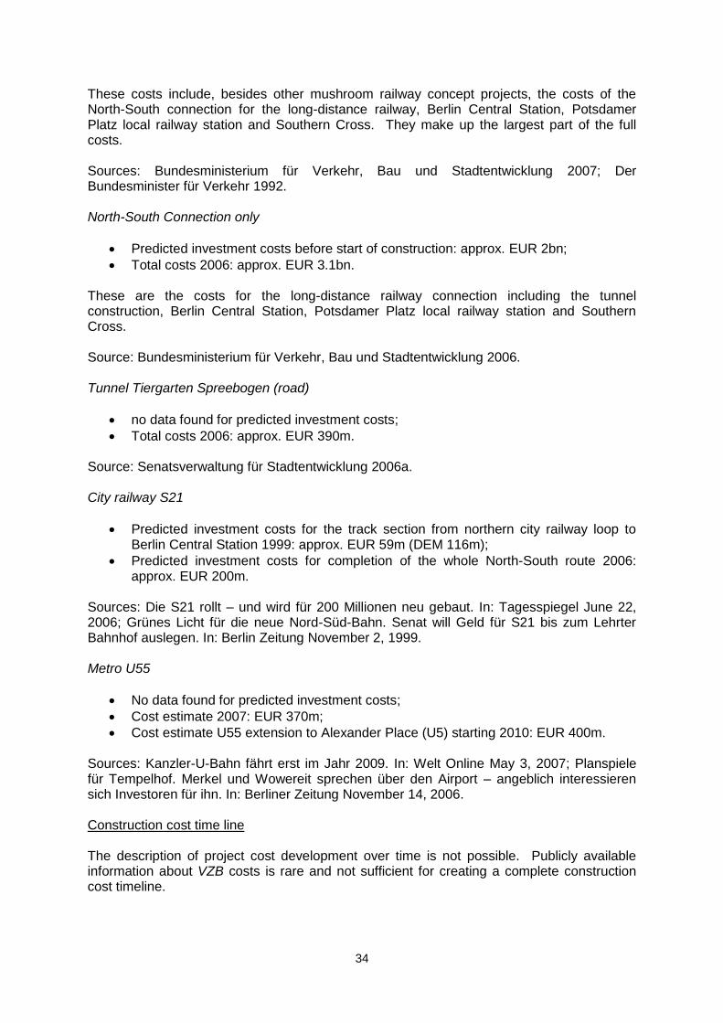
Table 5: Overview of project delivery ...............................................................................35
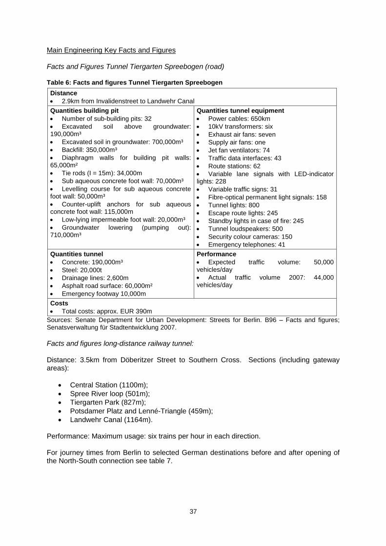
Table 6: Facts and figures Tunnel Tiergarten Spreebogen .............................................37
Table 7: Change of journey times due to North-South railway connection opening in 2006 .....................................................................................................................................38
Table 8: Overview of reported traffic volume ...................................................................47
6
A PROJECT INTRODUCTION
Type of project
Project name
Official project name: „Transport facilities in the central area‟ (Verkehrsanlagen im zentralen Bereich)
Official name road tunnel
„Tunnel Tiergarten Spreebogen‟ Popular names
Tiergartentunnel (mostly applied to the road tunnel);
North-South tunnel (mostly referred to the long-distance rail tunnel). Description of mode type The project around the Inner-City Rail & Road Tunnel Berlin consists of four physically separate but jointly planned road and rail tunnels:
Tunnel Tiergarten Spreebogen (TTS) for road traffic;
North-South Connection for long-distance railway;
Metro U5/55;
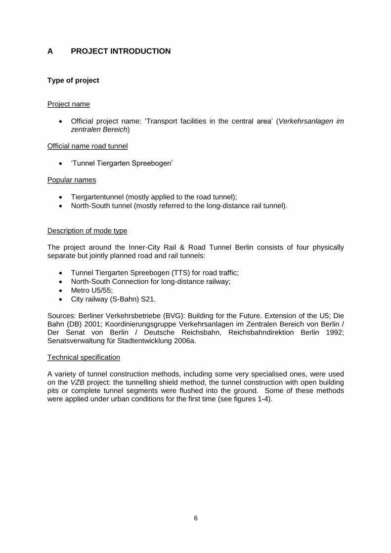
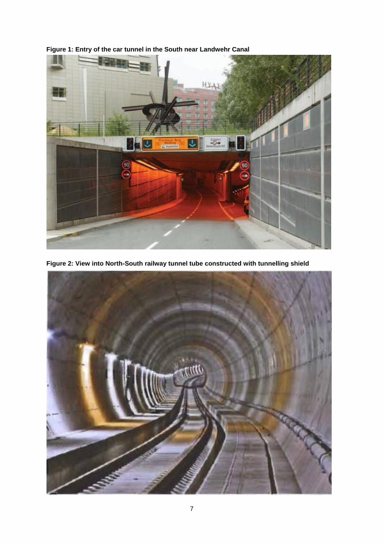
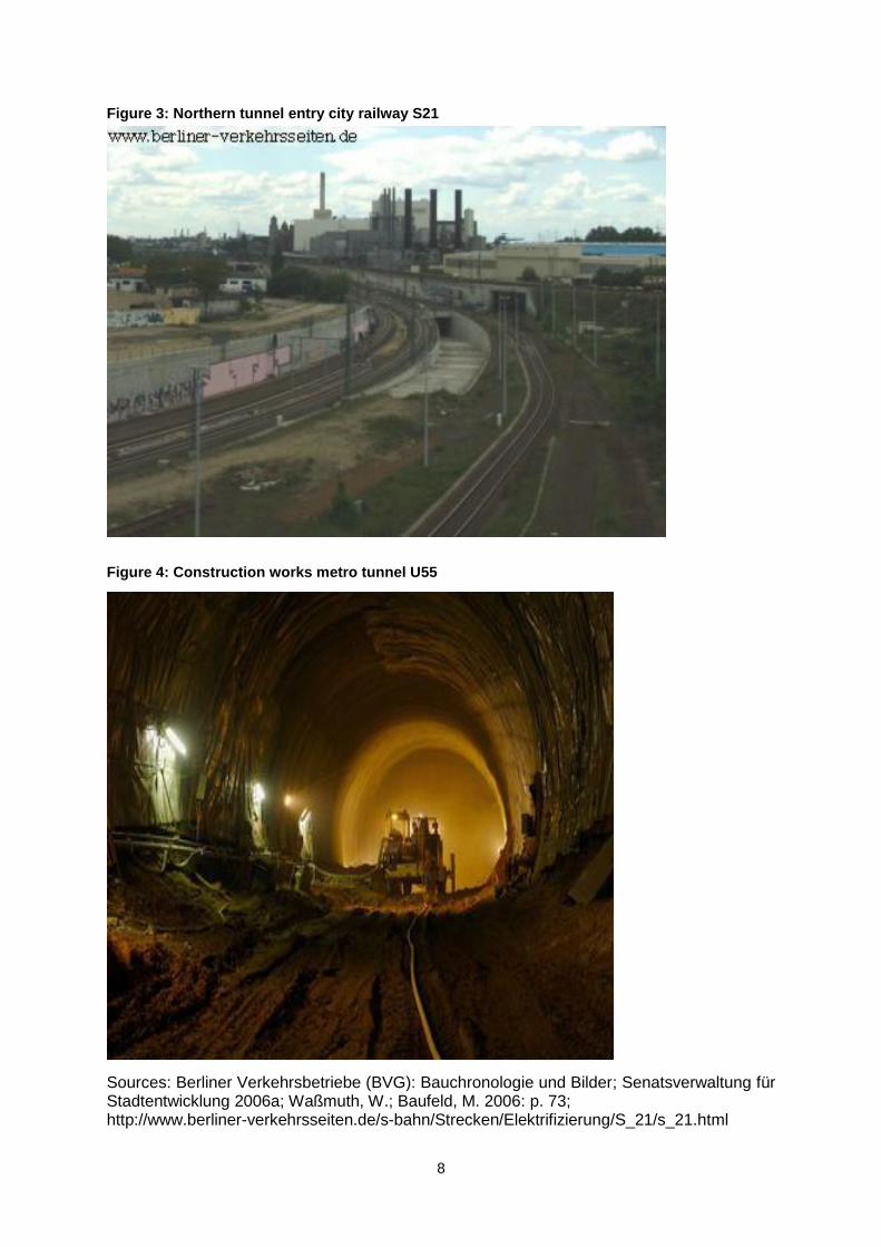
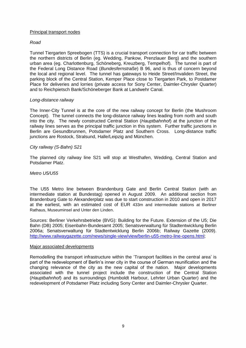
City railway (S-Bahn) S21. Sources: Berliner Verkehrsbetriebe (BVG): Building for the Future. Extension of the U5; Die Bahn (DB) 2001; Koordinierungsgruppe Verkehrsanlagen im Zentralen Bereich von Berlin / Der Senat von Berlin / Deutsche Reichsbahn, Reichsbahndirektion Berlin 1992; Senatsverwaltung für Stadtentwicklung 2006a. Technical specification A variety of tunnel construction methods, including some very specialised ones, were used on the VZB project: the tunnelling shield method, the tunnel construction with open building pits or complete tunnel segments were flushed into the ground. Some of these methods were applied under urban conditions for the first time (see figures 1-4).
7
Figure 1: Entry of the car tunnel in the South near Landwehr Canal
Figure 2: View into North-South railway tunnel tube constructed with tunnelling shield
8
Figure 3: Northern tunnel entry city railway S21
Figure 4: Construction works metro tunnel U55
Sources: Berliner Verkehrsbetriebe (BVG): Bauchronologie und Bilder; Senatsverwaltung für Stadtentwicklung 2006a; Waßmuth, W.; Baufeld, M. 2006: p. 73; http://www.berliner-verkehrsseiten.de/s-bahn/Strecken/Elektrifizierung/S_21/s_21.html
9
Principal transport nodes Road Tunnel Tiergarten Spreebogen (TTS) is a crucial transport connection for car traffic between the northern districts of Berlin (eg. Wedding, Pankow, Prenzlauer Berg) and the southern urban area (eg. Charlottenburg, Schöneberg, Kreuzberg, Tempelhof). The tunnel is part of the Federal Long Distance Road (Bundesfernstraße) B 96, and is thus of concern beyond the local and regional level. The tunnel has gateways to Heide Street/Invaliden Street, the parking block of the Central Station, Kemper Place close to Tiergarten Park, to Postdamer Place for deliveries and lorries (private access for Sony Center, Daimler-Chrysler Quarter) and to Reichpietsch Bank/Schöneberger Bank at Landwehr Canal. Long-distance railway The Inner-City Tunnel is at the core of the new railway concept for Berlin (the Mushroom Concept). The tunnel connects the long-distance railway lines leading from north and south into the city. The newly constructed Central Station (Hauptbahnhof) at the junction of the railway lines serves as the principal traffic junction in this system. Further traffic junctions in Berlin are Gesundbrunnen, Potsdamer Platz and Southern Cross. Long-distance traffic junctions are Rostock, Stralsund, Halle/Leipzig and München. City railway (S-Bahn) S21 The planned city railway line S21 will stop at Westhafen, Wedding, Central Station and Potsdamer Platz. Metro U5/U55 The U55 Metro line between Brandenburg Gate and Berlin Central Station (with an intermediate station at Bundestag) opened in August 2009. An additional section from Brandenburg Gate to Alexanderplatz was due to start construction in 2010 and open in 2017 at the earliest, with an estimated cost of EUR 433m and intermediate stations at Berliner
Rathaus, Museuminsel and Unter den Linden. Sources: Berliner Verkehrsbetriebe (BVG): Building for the Future. Extension of the U5; Die Bahn (DB) 2005; Eisenbahn-Bundesamt 2005; Senatsverwaltung für Stadtentwicklung Berlin 2006a; Senatsverwaltung für Stadtentwicklung Berlin 2006b; Railway Gazette (2009). http://www.railwaygazette.com/news/single-view/view/berlin-u55-metro-line-opens.html; Major associated developments Remodelling the transport infrastructure within the „Transport facilities in the central area‟ is part of the redevelopment of Berlin‟s inner city in the course of German reunification and the changing relevance of the city as the new capital of the nation. Major developments associated with the tunnel project include the construction of the Central Station (Hauptbahnhof) and its surroundings (Humboldt Harbour, Lehrter Urban Quarter) and the redevelopment of Potsdamer Platz including Sony Center and Daimler-Chrysler Quarter.
10
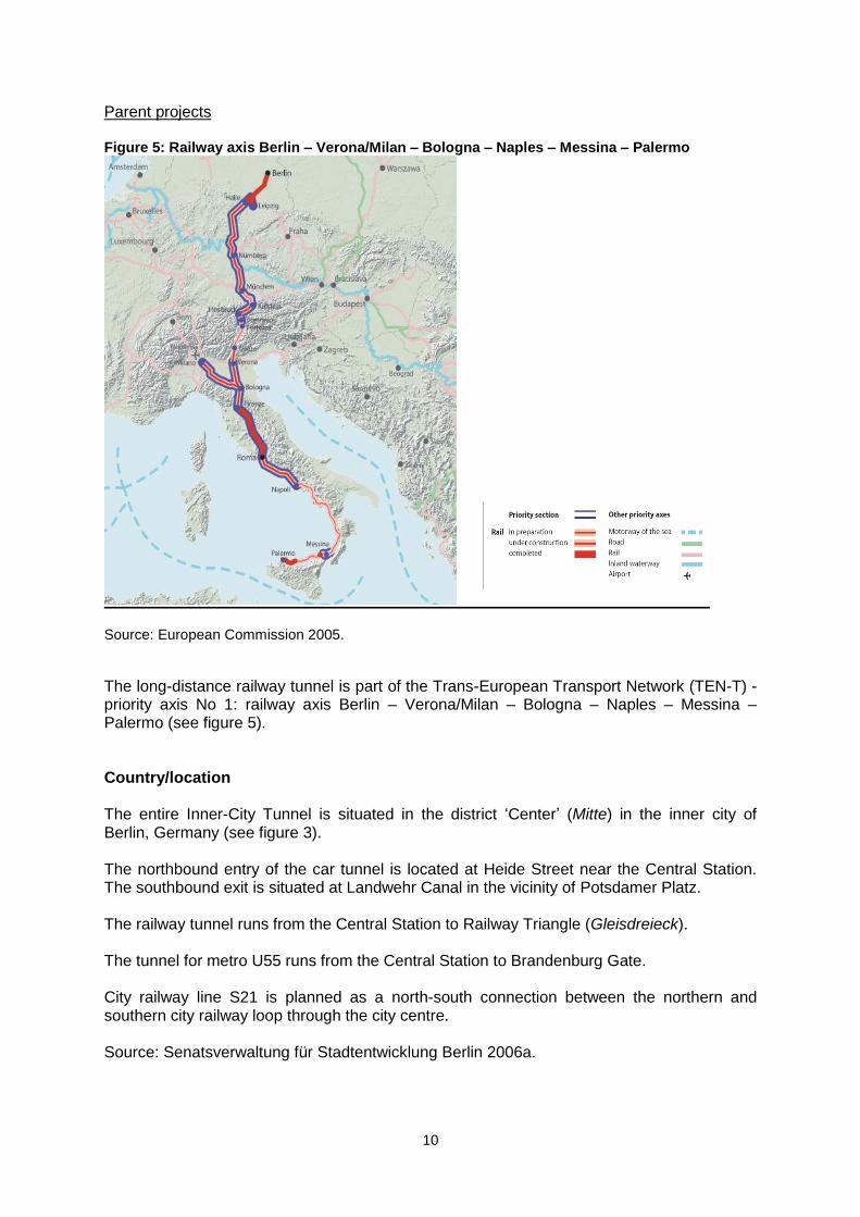
Parent projects Figure 5: Railway axis Berlin – Verona/Milan – Bologna – Naples – Messina – Palermo
Source: European Commission 2005.
The long-distance railway tunnel is part of the Trans-European Transport Network (TEN-T) - priority axis No 1: railway axis Berlin – Verona/Milan – Bologna – Naples – Messina – Palermo (see figure 5). Country/location The entire Inner-City Tunnel is situated in the district „Center‟ (Mitte) in the inner city of Berlin, Germany (see figure 3). The northbound entry of the car tunnel is located at Heide Street near the Central Station. The southbound exit is situated at Landwehr Canal in the vicinity of Potsdamer Platz. The railway tunnel runs from the Central Station to Railway Triangle (Gleisdreieck). The tunnel for metro U55 runs from the Central Station to Brandenburg Gate. City railway line S21 is planned as a north-south connection between the northern and southern city railway loop through the city centre. Source: Senatsverwaltung für Stadtentwicklung Berlin 2006a.
11
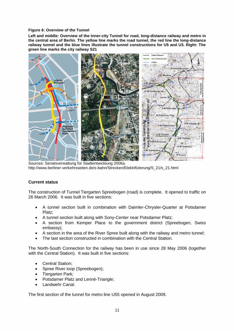
Figure 6: Overview of the Tunnel
Left and middle: Overview of the Inner-city Tunnel for road, long-distance railway and metro in the central area of Berlin. The yellow line marks the road tunnel, the red line the long-distance railway tunnel and the blue lines illustrate the tunnel constructions for U5 and U3. Right: The green line marks the city railway S21
Sources: Senatsverwaltung für Stadtentwicklung 2006a. http://www.berliner-verkehrsseiten.de/s-bahn/Strecken/Elektrifizierung/S_21/s_21.html
Current status The construction of Tunnel Tiergarten Spreebogen (road) is complete. It opened to traffic on 26 March 2006. It was built in five sections:
A tunnel section built in combination with Daimler-Chrysler-Quarter at Potsdamer Platz;
A tunnel section built along with Sony-Center near Potsdamer Platz;
A section from Kemper Place to the government district (Spreebogen, Swiss embassy);
A section in the area of the River Spree built along with the railway and metro tunnel;
The last section constructed in combination with the Central Station. The North-South Connection for the railway has been in use since 28 May 2006 (together with the Central Station). It was built in five sections:
Central Station;
Spree River loop (Spreebogen);
Tiergarten Park;
Potsdamer Platz and Lenné-Triangle;
Landwehr Canal. The first section of the tunnel for metro line U55 opened in August 2009.
12
City railway line S21 is in the process of planning (plan approval decision 2005). The start of construction is not finally settled. Parts of the construction works for S21 have been undertaken in the course of the North-South tunnel construction for the long-distance railway. Capacities Capacity of the road tunnel: Before opening, the expected traffic volume was 50,000 vehicles per day. In 2007, one year after bringing the tunnel into operation, the actual traffic volume amounted to 44,000 vehicles per day. Capacity of the long-distance railway tunnel: six trains per hour in each direction. Capacity metro U55: expected 6,400 passengers per workday. Sources: Berliner Verkehrsbetriebe (BVG): Building for the Future. Extension of the U5; Deutsche Bahn (DB) 2005; Senatsverwaltung für Stadtentwicklung Berlin 2006a; Senatsverwaltung für Stadtentwicklung 2006c; Senatsverwaltung für Stadtentwicklung 2007; Waßmuth, W.; Baufeld, M. 2006: pp. 62-63.
13
B PROJECT BACKGROUND
Principal project objectives Objectives formulated by the Government of Berlin and German Railways (Deutsche Bahn – DB) in the opening stages of the project „Transport facilities in the central area‟ in 1994:
Improvement of the transport infrastructure of Berlin especially against the background of German reunification and the changing relevance of the city (as the new seat of the German Government). This implies:
Building an adequate infrastructure for the higher traffic volume expected at that time (both long-distance and local traffic, railway, metro and road);
For the railway, integration into the national and European transport system, restructuring the railway network and technical modernisation.
Sources: Deutsche Bahn, Senatsverwaltung für Bau- und Wohnungswesen 1994; Projektgesellschaft Verkehrsanlagen im Zentralen Bereich Berlin mbH 1994. The principal objectives of the Government of Berlin relating to the road tunnel mainly affect urban development (before its opening in 2006):
Limitation of transit traffic in the area of Tiergarten Park (Berlin‟s largest inner city park ) and the government district, relieving the roads at ground level;
Absorption of higher traffic volume, caused by the newly constructed Potsdamer Platz and Central Station, by the road tunnel;
Use of land in the west of Potsdamer Platz and at the Central Station for other building projects (Lehrter Urban Quarter, Humboldt Harbour);
Strengthening of Tiergarten Park as an important place for flora, fauna and recreation.
Source: Senatsverwaltung für Stadtentwicklung 2006a. The principal objectives of German Railways relating to the long-distance railway tunnel (before its opening in 2005) were:
Reduced journey times especially on north-south routes (Berlin-Stralsund, Berlin-Leipzig);
Relieving loads on the east-west railway line, creating greater capacities, and improving the reliability of the railway service.
Source: Deutsche Bahn (DB) 2005. Route options There have been different route options for Berlin‟s railway system since the very beginning of the planning in the early 1990s: a circle concept, an axes concept and the chosen
14
mushroom concept. After the decision to choose the mushroom concept in 1993/1994 the routing for the entire „Transport facilities in the central area‟ did not change significantly. To a greater degree the implementation of the subprojects „city railway line S21‟ and „metro U5/U55‟ have been questioned during the planning process (due to financial problems and for being oversized for the local traffic volume). Due to these reasons, U55 will for the present have a shorter route than originally planned and the construction of S21 was temporarily put on ice. Sources: Berliner Verkehrsbetriebe (BVG): Building for the Future. Extension of the U5; Braun, M. 2004; Waßmuth, W.; Baufeld, M. 2006: pp. 18-23. Key enabling mechanisms Description of key enabling mechanisms Principal decision-makers: The construction of the transport facilities in the central area mainly resulted from the reunification of Germany and Berlin in 1990 and from the decision by the German Bundestag in 1991 to relocate the seat of the German Government to Berlin. Key enabling mechanisms timeline
Table 1: key enabling mechanisms timeline
Month Year Event
April 1991 Resolution of Federal Government on „Transport projects German Unity‟ (Verkehrsprojekte Deutsche Einheit). Project no. 8.3: investments in railroad connection from Berlin to Leipzig/Halle including Berlin Central Station hub.
June 1991 Hauptstadt-Beschluss: „Capital Resolution‟ of the German Bundestag: Berlin becomes the capital and seat of the German Government.
July 1992 On the basis of the German Federal Transport Infrastructure Plan 1992 (Bundesverkehrswegeplan 1992) the Federal Ministry of Transport (Bundesministerium für Verkehr) instructs the Government of Berlin and East German Railways (Deutsche Reichsbahn) to submit a joint plan for the transport facilities in the central area (Verkehrsanlagen im zentralen Bereich - VZB)
1993 Federal Ministry of Transport (Bundesministerium für Verkehr), State of Berlin and German Railways (Deutsche Bahn AG) establish a planning team responsible for the transport facilities in the central area (Projektgesellschaft für die Planung der Verkehrsanlagen im Zentralen Bereich Berlin – PVZB): Plan approval procedure (Planfeststellungsverfahren – PFV)
September October
1995 Plan approval decision (Planfeststellungsbeschluss) from the Federal Railway Authority (Eisenbahn-Bundesamt – EBA) for the VZB. Groundbreaking ceremony on 13 October 1995 with the Federal Chancellor Helmut Kohl, Federal Transport Minister Matthias Wissmann, Chairman of German Railways Heinz Dürr and the mayor of Berlin Eberhard Diepgen.
Sources: Bürgerinitiative Westtangente: Chronik. Waßmuth, W.; Baufeld, M. 2006.
Main organisations involved A great number of organisations were and still are involved in the planning, construction and operation of VZB. The reasons for this complex structure of organisations can be firstly found in the inclusion of different means of transportation, as well as in the integration of the
15
project in the redevelopment of Berlin‟s inner city. Secondly structures and responsibilities have changed in local and national administrative bodies and at German Railways in the course of the reunification process during the 1990s. Federal Government bodies and departments The following Federal Government bodies were involved in the project: German Bundestag On 20 June 1991 the members of German Parliament (Bundestag) decided for Berlin to be capital of the reunified nation. This resolution (Hauptstadtbeschluss) advanced the planning of transport facilities in the central area because relocating the government required the provision of an adequate transport infrastructure. Federal Government On 15 July 1992 the Government advocated plans for the mushroom concept (railway). Federal Ministry of Transport, Building and Urban Affairs (Bundesministerium für Verkehr, Bau und Stadtentwicklung) (former name: Federal Ministry of Transport) Responsibilities of the Ministry of Transport, Building and Urban Affairs:
The Ministry drew up a Federal Transport Infrastructure Plan in 1992 (Bundesverkehrswegeplan 1992). This document considered traffic forecasts for the year 2010, which served as a basis for the future development of German transport infrastructure. For Berlin the plan scheduled the extension of the transport node Berlin including the north-south railway connection. With the plan the Ministry provided assurance for project funding.
According to the „Act on expansion of federal track systems‟ (Gesetz über den Ausbau der Schienewege des Bundes-BSWAG) the Federal Government is under an obligation to finance the north-south railway connection.
The ministry also finances in a large part the road, metro and city railway tunnel. Sources: Bölke, J & Schäfer, P. 2006; Senatsverwaltung für Stadtentwicklung 2006b. Federal Railway Authority (Eisenbahn-Bundesamt – EBA) The Federal Railway Authority (EBA) accompanied the project in all phases. EBA was founded in 1994 as the controlling and approving authority for German Railways and is subordinated to the Federal Ministry for Transport, Building and Urban Affairs. EBA was not only involved in the planning and implementation of the North-South connection for railways but also participated in the planning phase of the entire „transport facilities in the central area‟. The responsibilities of the EBA with respect to VZB were:
Realization of plan approval procedure for the „transport facilities in the central area‟. EBA also took over the responsibility for the road and metro tunnel. Promoters of this controversial decision argued that railway infrastructure was the largest part of the entire project. A distribution of the plan approval procedure across three different government bodies would have caused many problems. For example it was

16
important to consider effects on the environment together, especially against the background of construction works under the River Spree and Tiergarten Park.
Consideration of all plan modifications after plan approval decision in 1995.
Building inspection for the construction of the railway tunnel: controlling state of construction, acceptance tests.
Inspection of operational safety of the newly constructed railway line (eg. fire control, evacuation plan railway tunnel).
EBA also conducted plan approval procedure for the city railway line S21, which was completed in 1995.
Sources: Bölke, J & Schäfer, P. 2006; Eisenbahnbundesamt – Außenstelle Berlin 2005. Forums and meetings On 19 March 1992 the leaders of German Federal Railways (Dürrr and Münchschwander) and East German Railways (Remmert) presented the Federal Transport Minister (Kraus) with their railway concept for Berlin (North-South Connection). Kraus agreed with their ideas and the detailed planning began. The Federal Ministry of Transport, Government of Berlin and German Railways established a team for the planning of „transport facilities in the central area‟ (Projektgesellschaft für die Planung der Verkehrsanlagen im Zentralen Bereich Berlin – PVZB) in 1993/94. This team consisted of three main consulting engineers (Emch + Berger Ingenieure und Planer, Schüßler-Plan Ingenieurberatung, DE-Consult) who conducted the plan. Source: Waßmuth, W & Baufeld, M. 2006: pp. 19, 173. Local government bodies/departments: Berlin Senate (Senat von Berlin) After the national decision for Berlin to become the German capital, the Berlin Senate passed a resolution on a basic concept of traffic planning for the central area (Grundlinien der Verkehrsplanung im zentralen Bereich) on 18 December 1991. Within the framework of this paper the Senate proposed an integrated traffic planning concept for the central area taking into account all means of transportation (long-distance, regional and city railway, metro, tramway and road traffic). The Senate considered the construction of a road tunnel in the inner city. Source: Senatsverwaltung für Verkehr und Betriebe Berlin 1995. Senate Department for Urban Development (Senatsverwaltung für Stadtentwicklung - SenStadt; former names: Senatsverwaltung für Bau- und Wohnungswesen; Senatsverwaltung für Verkehr und Betriebe Senatsverwaltung für Bauen, Wohnen und Verkehr) The Senate Department for Urban Development and its former counterparts took over responsibilities after the Berlin Senate‟s decision to promote an integrated traffic concept for the inner city (see above). The Department was significantly involved in the establishment of a team which conducted preliminary planning (PVZB) and acted as applicant for the plan
17
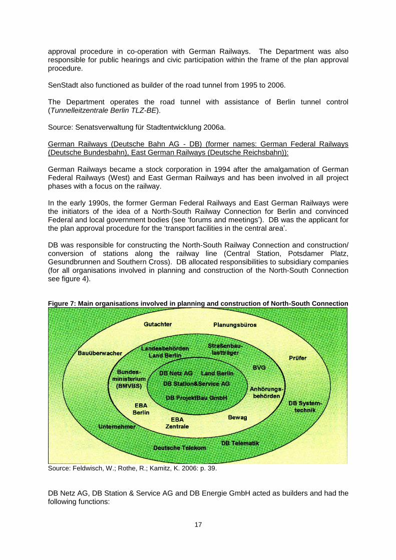
approval procedure in co-operation with German Railways. The Department was also responsible for public hearings and civic participation within the frame of the plan approval procedure. SenStadt also functioned as builder of the road tunnel from 1995 to 2006. The Department operates the road tunnel with assistance of Berlin tunnel control (Tunnelleitzentrale Berlin TLZ-BE). Source: Senatsverwaltung für Stadtentwicklung 2006a. German Railways (Deutsche Bahn AG - DB) (former names: German Federal Railways (Deutsche Bundesbahn), East German Railways (Deutsche Reichsbahn)): German Railways became a stock corporation in 1994 after the amalgamation of German Federal Railways (West) and East German Railways and has been involved in all project phases with a focus on the railway. In the early 1990s, the former German Federal Railways and East German Railways were the initiators of the idea of a North-South Railway Connection for Berlin and convinced Federal and local government bodies (see „forums and meetings‟). DB was the applicant for the plan approval procedure for the „transport facilities in the central area‟. DB was responsible for constructing the North-South Railway Connection and construction/ conversion of stations along the railway line (Central Station, Potsdamer Platz, Gesundbrunnen and Southern Cross). DB allocated responsibilities to subsidiary companies (for all organisations involved in planning and construction of the North-South Connection see figure 4). Figure 7: Main organisations involved in planning and construction of North-South Connection
Source: Feldwisch, W.; Rothe, R.; Kamitz, K. 2006: p. 39.
DB Netz AG, DB Station & Service AG and DB Energie GmbH acted as builders and had the following functions:
18
orders/bookings;
internal approvals DB;
project modifications;
budget planning and controlling;
project financing;
monitoring of costs, appointments and quality;
risk acquisition and evaluation;
regular reporting to executive committee DB;
commissioning. DB ProjektBau GmbH was responsible for project management and was involved in:
plan approval procedure;
tendering;
completion of contracts with civil engineers;
obtaining construction approval from EBA;
planning of costs, appointments, quality;
risk analysis;
acceptance of construction works. A superior board of representatives from DB Netz AG and DB Station & Service AG was implemented in 2002 for completion of the project. This decision-making body had close contact with the DB executive committee. DB and its subsidiary companies (DB Fernverkehr AG, DB Regio AG) have been the operators of the North-South Connection since its opening on 28 May 2006. DB Netz AG was the applicant for the plan approval procedure for city railway line S21, which has been completed with plan approval decision in 2005. Sources: Eisenbahnbundesamt – Außenstelle Berlin 2005; Feldwisch, W.; Rothe, R.; Kamitz, K. 2006. Berlin Transport Authority (Berliner Verkehrsbetriebe - BVG) Berlin Transport Authority is currently responsible for building and operating metro line U55, by order of the Senate Department for Urban Development. Source: Berliner Verkehrsbetriebe (BVG): Building for the Future. Extension of the U5. Pressure Groups In 1993 about 50 initiatives, organisations and parties formed an alliance called „Anti-Tunnel GmbH‟ against the planned tunnel. Main stakeholders of this group
Public campaign bypass west (Bürgerinitiative Westtangente e.V.). Established in 1974, the primary aim of the action group was to prevent the construction of an urban motorway (called bypass west) in the western districts of Berlin. The plan was never completed, but Tunnel Tiergarten Spreebogen is part of the marked-out route of the formerly planned urban motorway. For this reason the public campaign wanted to prevent the implementation of the „transport facilities in the central area‟, too.

19
Berlin conservation working group (Berliner Landesarbeitsgemeinschaft Naturschutz e.V. – BLN) is a service facility for public campaigns and organisations interested in conservation issues. The group coordinated a joint statement of „Anti-Tunnel GmbH‟ towards the planning of „transport facilities in the central area‟.
Objectives and measures of ‘Anti-Tunnel GmbH’ The organisation mainly accompanied the plan approval procedure for „transport facilities in the central area‟ and took part in civic participation activities. Centerpiece was a broad written statement on this plan published in 1994. The pressure group feared adverse environmental effects especially on Tiergarten Park. Within tunnel construction works under the park a drawdown was predicted, with negative consequences on the local flora and fauna. Due to the efforts of „Anti-Tunnel GmbH‟ ground water monitoring was established. Besides this very special point of issue „Anti-Tunnel GmbH promoted ecological urban planning and a rethink of transport policy to the benefit of pedestrians, cyclists and local public transport. From their point of view the planning for „transport facilities in the central area‟ disregarded these aspects:
Tunnel Tiergarten Spreebogen would generate more car traffic in the inner city.
The mushroom railway concept would not match with the polycentric structures of the city. There were less expensive and more practical alternatives.
Building a new metro line would be far more expensive than the extension of tramway lines.
After the plan approval decision in 1995 „Anti-Tunnel GmbH‟ tried to take legal action against this decision before the Federal Administrative Court (official complainant: BLN). This action was dismissed for formal reasons in 1996. Nature conservation organisations like BLN did not have the right of action on a federal level at that time. A simultaneously submitted application for a building freeze was defeated. Demonstrations and protest actions were organized by „Anti-Tunnel GmbH‟ within the groundbreaking ceremony for the construction project in 1995 and the opening of Tunnel Tiergarten Spreebogen in 2006. Sources: Berliner Landesarbeitsgemeinschaft Naturschutz (BLN); Anti-Tunnel-GmbH 1994; Bürgerinitiative Westtangente: Chronik. Contractors The (civil engineering) contractors that were involved in the construction of the „transport facilities in the central area‟ can be divided into three groups. The first group were contractors of German Railways and its subsidiary companies, and participated in the construction of the North-south connection for the long-distance railway (see table 2).
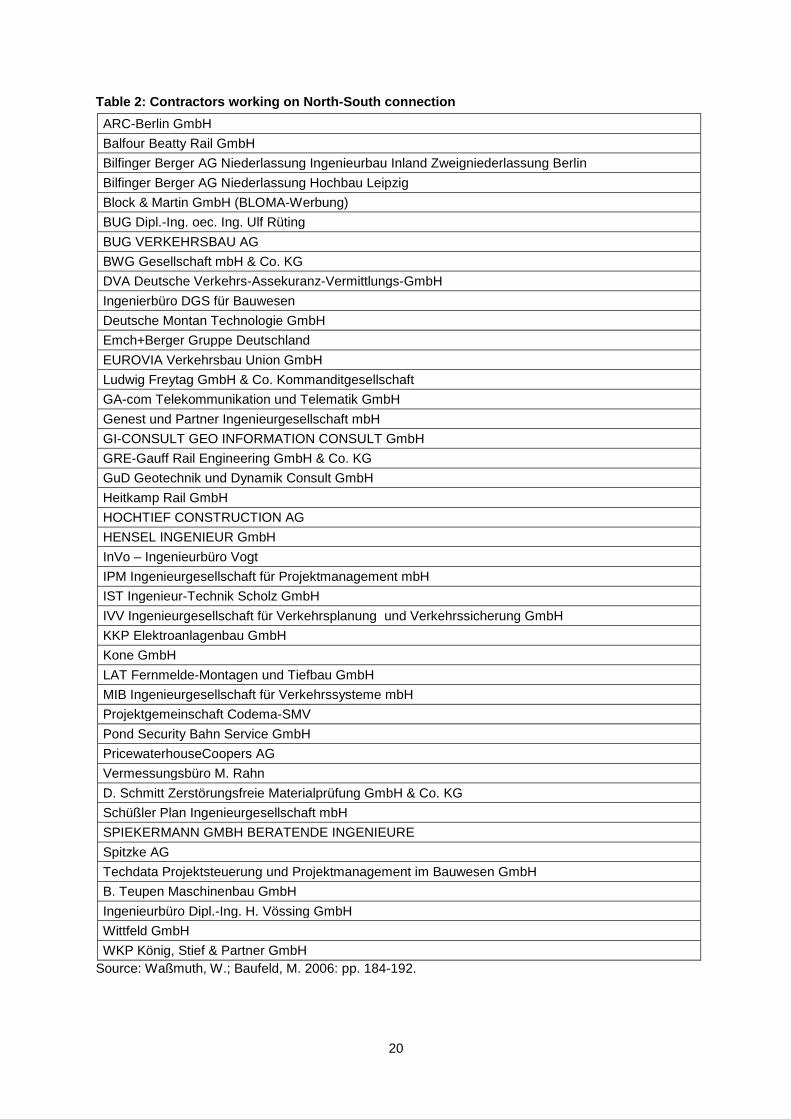
20
Table 2: Contractors working on North-South connection
ARC-Berlin GmbH
Balfour Beatty Rail GmbH
Bilfinger Berger AG Niederlassung Ingenieurbau Inland Zweigniederlassung Berlin
Bilfinger Berger AG Niederlassung Hochbau Leipzig
Block & Martin GmbH (BLOMA-Werbung)
BUG Dipl.-Ing. oec. Ing. Ulf Rüting
BUG VERKEHRSBAU AG
BWG Gesellschaft mbH & Co. KG
DVA Deutsche Verkehrs-Assekuranz-Vermittlungs-GmbH
Ingenierbüro DGS für Bauwesen
Deutsche Montan Technologie GmbH
Emch+Berger Gruppe Deutschland
EUROVIA Verkehrsbau Union GmbH
Ludwig Freytag GmbH & Co. Kommanditgesellschaft
GA-com Telekommunikation und Telematik GmbH
Genest und Partner Ingenieurgesellschaft mbH
GI-CONSULT GEO INFORMATION CONSULT GmbH
GRE-Gauff Rail Engineering GmbH & Co. KG
GuD Geotechnik und Dynamik Consult GmbH
Heitkamp Rail GmbH
HOCHTIEF CONSTRUCTION AG
HENSEL INGENIEUR GmbH
InVo – Ingenieurbüro Vogt
IPM Ingenieurgesellschaft für Projektmanagement mbH
IST Ingenieur-Technik Scholz GmbH
IVV Ingenieurgesellschaft für Verkehrsplanung und Verkehrssicherung GmbH
KKP Elektroanlagenbau GmbH
Kone GmbH
LAT Fernmelde-Montagen und Tiefbau GmbH
MIB Ingenieurgesellschaft für Verkehrssysteme mbH
Projektgemeinschaft Codema-SMV
Pond Security Bahn Service GmbH
PricewaterhouseCoopers AG
Vermessungsbüro M. Rahn
D. Schmitt Zerstörungsfreie Materialprüfung GmbH & Co. KG
Schüßler Plan Ingenieurgesellschaft mbH
SPIEKERMANN GMBH BERATENDE INGENIEURE
Spitzke AG
Techdata Projektsteuerung und Projektmanagement im Bauwesen GmbH
B. Teupen Maschinenbau GmbH
Ingenieurbüro Dipl.-Ing. H. Vössing GmbH
Wittfeld GmbH
WKP König, Stief & Partner GmbH
Source: Waßmuth, W.; Baufeld, M. 2006: pp. 184-192.

21
The second group of (civil engineering) contractors worked on the road tunnel and were contractors of the Senate Department for Urban Development (see table 3). Table 3: Contractors working on road tunnel
Alpine Bau Deutschland AG
Brendel Ingenieure
BSG
Bung AG - Beratende Ingenieure
Johann Bunte Baununternehmung GmbH & Co. KG
Cegelec Solutions & Services
EUROVIA Verkehrsbau Union GmbH
GUD Consult GmbH
GUF Heizung & Sanitärmontagen GmbH
Ingenieurbüro Vössing GmbH
IPM Ingenieurgesellschaft für Projektmanagement mbH
IVZ Berlin Ingenieurgemeinschaft für die Planung der Verkehrsanlagen im Zentralen Bereich
Krebs und Kiefer beratende Ingenieure für das Bauwesen
Lahmeyer Berlin Ingenieurgesellschaft
MABAU Niederlassung Berlin
Max Bögl Bauservice GmbH & Co. KG
PTV traffic mobility logistics
Prüfingenieur statisch/Konstruktive Prüfung Dipl.-Ing. Traugott Rostalski
Siemens
SMV Bauprojektsteuerung Ingenieurgesellschaft mbH
STRABAG
Schüßler-Plan Ingenieurgesellschaft mbH
Techdata Projektsteuerung und Projektmanagement im Bauwesen GmbH
VEPRO Verkehrsbau Projekt GmbH Ingenieurbüro Bau- und Verkehrswesen
Weiss-Electronic GmbH
Fa. Würthle, Kassel, Brandschutzsysteme, Sonderkonstruktionen
Züblin Spezialtiefbau GmbH
Source: Senatsverwaltung für Stadtentwicklung 2006b.
The third group, contractors of Senate Department for Urban Development and Berlin Transport Authority, have been involved in construction of the tunnel for metro line U55 (see table 4). Table 4: Contractors working on metro tunnel
CDM Consult GmbH
Deutsche Montan Technologie GmbH (DMT)
Hochtief Construction AG
Klein Ingenieure
Max Bögl Bauservice GmbH & Co. KG
PSP beratende Ingenieure für Tunnelbau, Grund- und Ingenieurbau
Zerna Ingenieure GmbH (ZKP)
Source: Berliner Verkehrsbetriebe (BVG): Unsere Links + Partner.
22
Planning and environmental regime Outline of planning legislation In Germany planning of mega transport projects differs from the regular planning regime and usually includes a „regional planning procedure‟ (Raumordnungsverfahren – ROV) and a „plan approval procedure‟ (Planfeststellungsverfahren – PFV) (see Peters 2008a: 11-12). Crucial to VZB was the second procedure concluding with the plan approval decision in 1995 as mentioned above. A further key part was the land use plan (Flächennutzungsplan - FNP) for Berlin released in 1994. Tunnels of VZB were designated in this document and it is to be assumed that an initial regional planning procedure did not proceed for that reason. In §22(4) in the treaty on state spatial planning between Berlin and Brandenburg (Landesplanungsvertrag) from 1995 it is arranged that the content of FNP „94 corresponds with the superior aims of spatial and regional planning. According to that a regional planning procedure for VZB, which examines exactly these aims, was not required. But it should be pointed out that the treaty entered into force years after the process of planning VZB began in the early 1990s. It is difficult to reproduce the precise progress of events in this early period after German Reunification, when joint planning legislation for Eastern and Western Germany was still in progress. Source: Land Berlin; Land Brandenburg 1995; Peters, D. 2008a; Senatsverwaltung für Stadtentwicklung 1994. Environmental statements The plan approval procedure for VZB was accompanied by a statutory environmental impact assessment (EIA) (Umweltverträglichkeitsprüfung – UVP). This survey contains an anticipatory analysis and evaluation of the possible environmental effects of the planned project. The main finding of the study was of significant effects on the environment not only during the construction phase (eg. noise and dust emissions; drawdown) but also after completion (eg. modification of large areas) may be expected. But the realization of broad compensation measures, as also claimed in the survey, would reduce the negative consequences of the project to a minimum. Besides the EIA, the annotations to plan approval procedure also contained special environmental surveys on soil/subsoil, water regime, air pollutants, echo/convulsion and electromagnetic tolerance. „Anti-Tunnel GmbH‟ criticized the environmental impact assessment procedure for VZB in their written statement to the plan approval procedure. The organisation mainly indicated that lack of data and time had made an adequate analysis of the project‟s broad environmental consequences impossible. Compensation measures for the construction of VZB were specified within landscape preservation planning (Landschaftspflegerische Begleitplanung) and were also part of the plan approval procedure according to §14 Nature Conservation Act Berlin (Naturschutzgesetz Berlin - NatSchGBln). By balancing expected land consumption and loss of biovolume, compensation measures were determined, such as unsealing, greening, tree planting and building of noise barriers (see „Ecological mitigation‟ below). Source: Berliner Landesarbeitsgemeinschaft Naturschutz (BLN); Anti-Tunnel-GmbH 1994; Deutsche Bahn (DB); Senatsverwaltung für Bau- und Wohnungswesen 1994; Schröder, R. ; Barsig, M. 2004.
23
Overview of public consultation Public consultation was integrated in the planning process at different points in time:
Tunnel construction was subject of discussion in early civic participation procedure (vorgezogene Bürgerbeteiligung) for land use plan Berlin and for coordinated local plan Postdamer Place/Leipziger Place (Koordinierter Bebauungsplan Potsdamer Platz/Leipziger Platz) in 1992/1993. That way especially public campaign bypass west tried to intervene in the „tunnel project‟ at an early stage. For example 1,300 objections to the road tunnel were advanced within civic participation for the coordinated local plan Potsdamer Platz/Leipziger Place.
The public display of Berlin‟s land use plan in 1993 brought about 19,000 objections to traffic planning including tunnel construction.
Civic participation is also an integrated step in plan approval procedure combined with EIA. Public display for VZB proceeded in a four-week period in 1995, where all affected stakeholders had the opportunity to comment on the plan. Subsequent to this event „Anti-Tunnel GmbH‟ and BLN published their broad statement on the plan.
Sources: Bürgerinitiative Westtangente: Chronik; Deutscher Bundestag 1995. Ecological mitigation Ecological mitigation measures were developed within the scope of previously mentioned landscape preservation planning (Landschaftspflegerische Begleitplanung). The following compensatory measures were related to the railway construction:
Generation of a 33,000m² park/ green corridor at Döberitzer Street;
Unsealing of so-called Entlastungsstraße, a temporary built street crossing Tiergarten Park which was part of the former routing of B96;
Greening and plantation of banks along the train path;
Protection of succession and ruderal areas along the train path;
Greening of noise barriers along Mettmann Park and Bautzener Street;
Tree planting in Tiergarten Park. As compensatory measures for B96 and Metro U55 the following were intended:
Conversion of a former railway yard in nature park Schöneberger Südgelände (about 180,000m²);
Unsealing and redevelopment measures at the following places:
Public Park Prenzlauer Berg;
former tramway depot Wiebe Street in Center-Tiergarten;
Junker Street in Kreuzberg;
three schoolyards in Wedding;
three schoolyards in Friedrichshain;
one schoolyard in Kreuzberg;
two schoolyards in Neukölln;
one schoolyard in Steglitz;
Sparr Place in Wedding;
Planting of 17,411 trees in different districts of Berlin;
24
Construction of a pedestrian and cyclist bridge over Charlottenburger Canal (Charlottenburger Verbindungskanal).
Critique The Cooperation and Advice Center for environmental issues (Kooperations- und Beratungsstelle für Umweltfragen – Kubus) at Berlin Institute of Technology (Technische Universität Berlin) made investigations into the stage of work of abovementioned compensatory measures in 2004 by order of BLN. In their spot survey they conclude that some of the measures were not implemented. Others were transacted with delay and at a long distance from the construction zones of VZB. Sources: Deutsche Bahn (DB); Senatsverwaltung für Bau- und Wohnungswesen 1994; Schröder, R; Barsig, M. 2004. Regeneration The construction of VZB with the new Central Station at its current location north of the new government quarter presents a major potential impetus for the large-scale urban regeneration of the three adjacent sites, the Lehrter Urban quarter, the Heidestrasse quarter and the Humboldt harbour (described further below). While this was clearly recognized as an opportunity for regeneration by the relevant decision-makers at German Railways and the Berlin Senate, no concrete regeneration scheme was linked to the VZB project at the time, nor were the potential gains from future development opportunities a central determining factor in the decision to build the tunnel and the station. Due to serious overbuilding in the Berlin real estate market in the 1990s and 2000s, especially in the commercial properties market, the proposed regeneration schemes at the three sites are only now slowly coming into fruition. Appraisal methods German Federal Transport Infrastructure Plan 1992 A large part of the VZB project, the North-South connection for long-distance railway, was appraised before construction within the Federal Transport Infrastructure Plan of 1992. Various appraisal criteria were considered:
Macroeconomic appraisal: cost-benefit analysis;
Ecological appraisal: environmental risk analysis;
Economic viability of railway operations;
Further criteria. As a result the North-South long-distance railway connection has been categorized as urgent/prior needs. Plan approval procedure 1993-1995 Within the scope of the plan approval procedure the VZB project has been appraised to some extent once again before construction. As already mentioned mainly environmental topics were considered:
Environmental impact assessment (EIA);
Special environmental surveys in soil and subsoil, water regime, air pollutants, echo/convulsion and electromagnetic tolerance.

25
Monitoring environmental variables during construction Groundwater is an important topic for construction works in Berlin‟s inner city because it can be found already at a depth of three metres. Due to that, the construction phase was accompanied by computer based groundwater monitoring with focus on prevention of drawdown for protection of Tiergarten Park‟s flora. However, this monitoring unfortunately could not prevent a flood on the construction site of the southern railway tunnel section at railway triangle (Gleisdreick) in 1997. Sources: Azer, Hany 2006a; Der Bundesminister für Verkehr 1992; Projektgesellschaft für Verkehrsanlagen im Zentralen Bereich Berlin (PVZB) 1994a. Complaints procedures Complaints procedures were integrated into the official plan approval procedure, as part of the public participation procedures. In 1995, the BLN, with the assistance of „Anti-Tunnel GmbH‟, went to court against the VZB, mainly on the basis of the potential ecological damage the tunnel construction might cause to the Tiergarten Park. The complaint was unsuccessful. Land acquisition The State of Berlin and German Railways tried to build the „traffic facilities in the central area‟ mainly on their own property. If third parties were affected, there were three types of land acquisition:
Land acquisition in case of using the area for construction;
Seizure of permanent use if usage of land is limited because of the tunnel below ground level;
Seizure of temporary use if usage of land is limited during construction works. No precise information is available at this point in time. Further data can be found in the land acquisition catalogue of plan approval decision volume 18 attachment 8. Source: Deutsche Bahn (DB); Senatsverwaltung für Bau- und Wohnungswesen 1994.
26
C PRINCIPAL PROJECT CHARACTERISTICS
Detailed description of route The route description of the VZB project can be subdivided into the different modes of transportation involved: Long-distance railway tunnel The north-south railway line, coming from Southern Cross, enters the tunnel on the grounds of the former Potsdamer goods station (Potsdamer Güterbahnhof) south of Landwehr Canal in Berlin‟s southern central area. It leads northwards underneath Landwehr Canal to the shopping and entertainment centre, Potsdamer Platz, where trains can stop at the new local railway station. The tunnel then passes Tiergarten Park towards the Place of the Republic (Platz der Republik) in the Federal Government District, goes underneath the River Spree west of Humboldt Harbour and reaches the Central Station. Going northbound the tunnel finishes at Döberitzer Street. Further north the railway line divides into tracks going eastwards to Gesundbrunnen Station and westwards to Spandau Station. Tunnel Federal long distance road (Bundesfernstraße) B96 – Tunnel Tiergarten Spreebogen – TTS The TTS route begins in the southern regions of Berlin‟s inner city, with connections to the roads Reichpietsch Bank and Schöneberger Bank along the Landwehr Canal. Northwards, TTS leads to Potsdamer Platz and to Tiergarten Park, where gateways enable private access for deliveries to the Sony Center and Daimler Chrysler Quarter and public access to Kemper Place. These sections run about 150m to 300m west of the long-distance railway tunnel. TTS then reaches the Federal Government District. South of the Swiss Embassy in the area of Otto-von Bismarck-Avenue, TTS goes east approaching the railway tunnel. After that it leads underneath the River Spree, goes past Central Station, where it has a gateway to the parking block, and ends north of Invaliden Street with a connection to Heide Street. Tunnel metro U5/U55 The metro tunnel begins in close vicinity to Brandenburg Gate at Pariser Place. The U55 will have a stop at „Among Lime trees‟ (Unter den Linden). The tunnel first leads a short way eastwards, then northwards into the Government District. Another metro stop is planned at the lower house of the German Parliament (Bundestag). After that the tunnel leads underneath the River Spree, next to the railway and road tunnel, reaches Central Station and ends to the north of it at Döberitzer Street. City railway S21 The complete route of the city railway line S21 is not yet fixed. The part officially approved so far starts at the northern side of Berlin‟s inner city railway loop with tracks from Wedding Station and Westhafen Station that become a joint railway line on the way south towards Central Station. The second planned route section leads from Central Station to Potsdamer Platz with intermediate stops at the lower house of the German Parliament (Bundestag) and Brandenburg Gate. In the long term a last section is planned from Potsdamer Platz Station via Railway Triangle Station (providing a connection to the metro lines U1 and U2) to the southern side of the inner city railway loop.
27
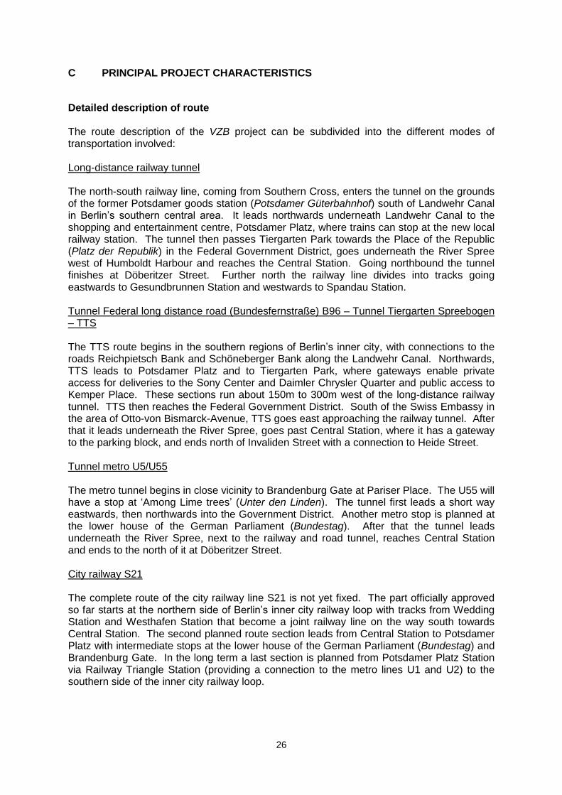
Sources: Bundesverwaltungsgericht 1995. Bau neuer S-Bahn zum Hauptbahnhof noch ungewiss. Geld für die geplante Nord-Süd-Strecke S 21 ist da. Ein Termin steht nicht fest – Senat und Bahn streiten. In: Tagesspiegel July 23, 2006. Detailed description of main and intermediate travel nodes Stations along the North-South railway connection (see figure 5) started operations on 28 May 2006 along with the opening of the long-distance railway tunnel. Planning and development of these travel nodes will be described below. Routing of all VZB projects largely follows the long-distance railway connection. For this reason emphasis is put on the main railway stations in this system. Figure 8: Travel nodes along North-South railway connection
(Gesundbrunnen, Central Station (see Hbf), Potsdamer Platz, Südkreuz)
Source: Die Bahn (DB) 2005.
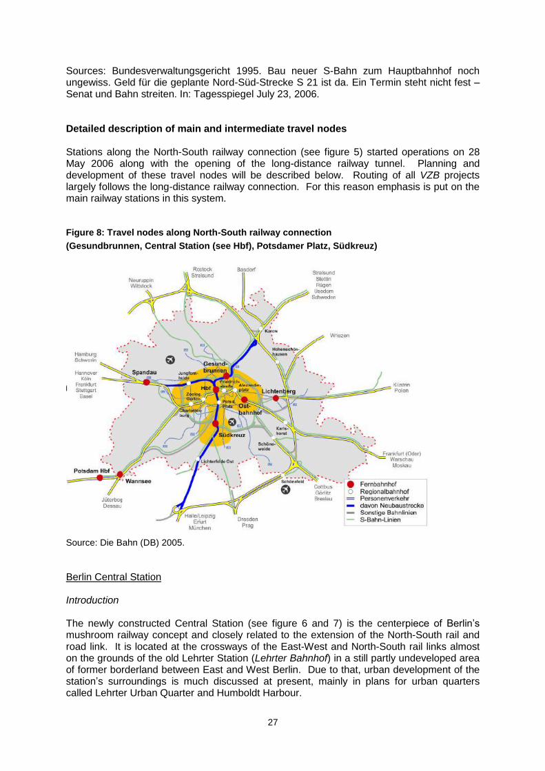
Berlin Central Station Introduction The newly constructed Central Station (see figure 6 and 7) is the centerpiece of Berlin‟s mushroom railway concept and closely related to the extension of the North-South rail and road link. It is located at the crossways of the East-West and North-South rail links almost on the grounds of the old Lehrter Station (Lehrter Bahnhof) in a still partly undeveloped area of former borderland between East and West Berlin. Due to that, urban development of the station‟s surroundings is much discussed at present, mainly in plans for urban quarters called Lehrter Urban Quarter and Humboldt Harbour.
28
Figure 9: Berlin Central Station under construction
Source: Deutsche Bahn (DB) 2005.
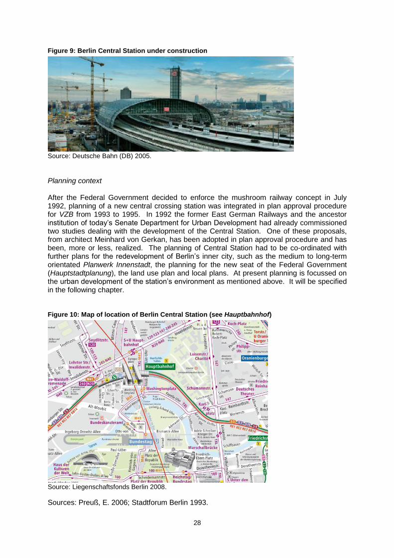
Planning context After the Federal Government decided to enforce the mushroom railway concept in July 1992, planning of a new central crossing station was integrated in plan approval procedure for VZB from 1993 to 1995. In 1992 the former East German Railways and the ancestor institution of today‟s Senate Department for Urban Development had already commissioned two studies dealing with the development of the Central Station. One of these proposals, from architect Meinhard von Gerkan, has been adopted in plan approval procedure and has been, more or less, realized. The planning of Central Station had to be co-ordinated with further plans for the redevelopment of Berlin‟s inner city, such as the medium to long-term orientated Planwerk Innenstadt, the planning for the new seat of the Federal Government (Hauptstadtplanung), the land use plan and local plans. At present planning is focussed on the urban development of the station‟s environment as mentioned above. It will be specified in the following chapter. Figure 10: Map of location of Berlin Central Station (see Hauptbahnhof)
Source: Liegenschaftsfonds Berlin 2008.
Sources: Preuß, E. 2006; Stadtforum Berlin 1993.
29
Proposed development and key features Figures, Berlin Central Station:
Three-floor building;
70,000m² of floor space;
15,000m² of commercial space;
225 long-distance trains daily;
325 regional trains daily;
627 city railway trains daily;
An estimated 300,000 visitors and travellers daily;
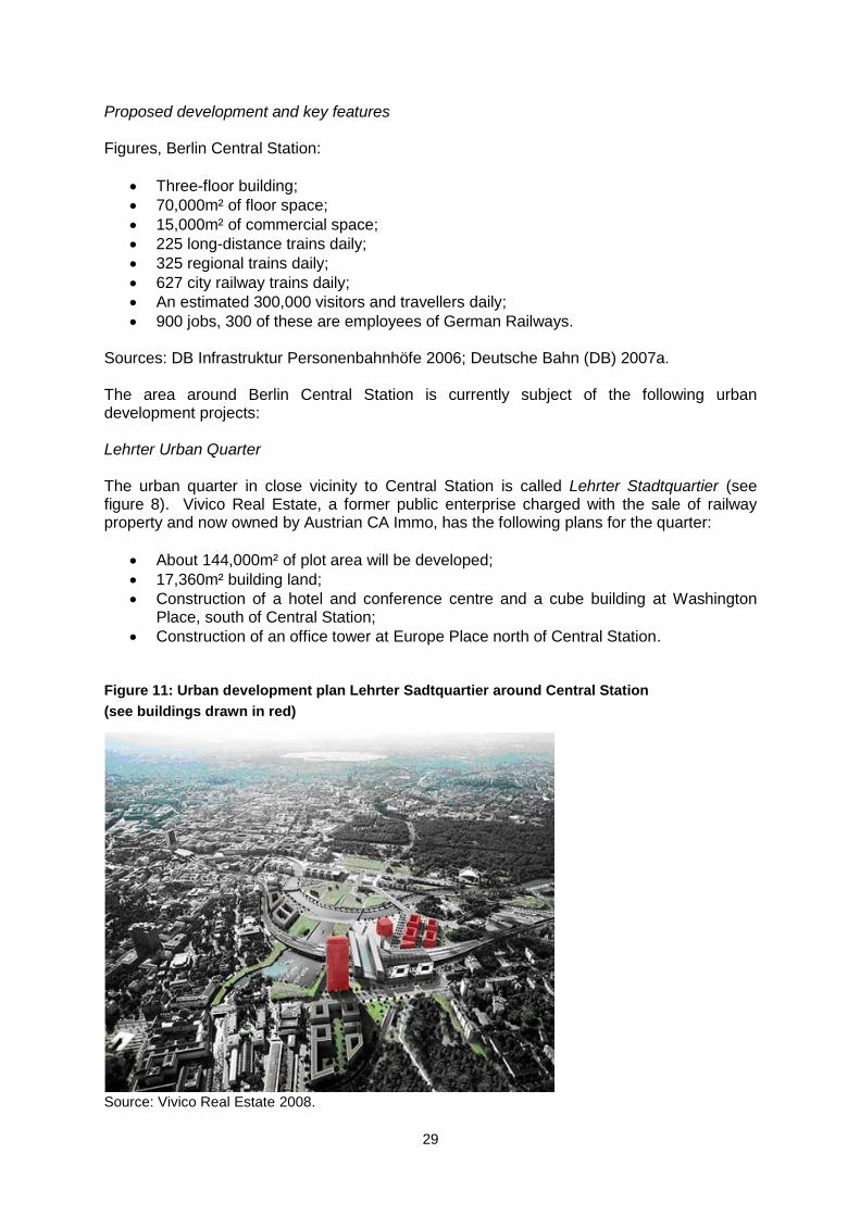
900 jobs, 300 of these are employees of German Railways. Sources: DB Infrastruktur Personenbahnhöfe 2006; Deutsche Bahn (DB) 2007a. The area around Berlin Central Station is currently subject of the following urban development projects: Lehrter Urban Quarter The urban quarter in close vicinity to Central Station is called Lehrter Stadtquartier (see figure 8). Vivico Real Estate, a former public enterprise charged with the sale of railway property and now owned by Austrian CA Immo, has the following plans for the quarter:
About 144,000m² of plot area will be developed;
17,360m² building land;
Construction of a hotel and conference centre and a cube building at Washington Place, south of Central Station;
Construction of an office tower at Europe Place north of Central Station. Figure 11: Urban development plan Lehrter Sadtquartier around Central Station
(see buildings drawn in red)
Source: Vivico Real Estate 2008.
30
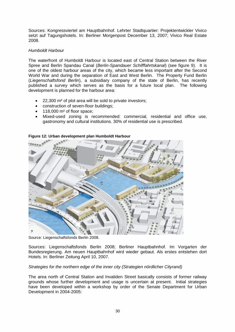
Sources: Kongressviertel am Hauptbahnhof. Lehrter Stadtquartier: Projektentwickler Vivico setzt auf Tagungshotels. In: Berliner Morgenpost December 13, 2007; Vivico Real Estate 2008. Humboldt Harbour The waterfront of Humboldt Harbour is located east of Central Station between the River Spree and Berlin Spandau Canal (Berlin-Spandauer Schifffahrtskanal) (see figure 9). It is one of the oldest harbour areas of the city, which became less important after the Second World War and during the separation of East and West Berlin. The Property Fund Berlin (Liegenschaftsfond Berlin), a subsidiary company of the state of Berlin, has recently published a survey which serves as the basis for a future local plan. The following development is planned for the harbour area:
22,300 m² of plot area will be sold to private investors;
construction of seven-floor buildings;
118,000 m² of floor space;
Mixed-used zoning is recommended: commercial, residential and office use, gastronomy and cultural institutions. 30% of residential use is prescribed.
Figure 12: Urban development plan Humboldt Harbour
Source: Liegenschaftsfonds Berlin 2008.
Sources: Liegenschaftsfonds Berlin 2008; Berliner Hauptbahnhof. Im Vorgarten der Bundesregierung. Am neuen Hauptbahnhof wird wieder gebaut. Als erstes entstehen dort Hotels. In: Berliner Zeitung April 10, 2007. Strategies for the northern edge of the inner city (Strategien nördlicher Cityrand) The area north of Central Station and Invaliden Street basically consists of former railway grounds whose further development and usage is uncertain at present. Initial strategies have been developed within a workshop by order of the Senate Department for Urban Development in 2004-2005:
31
50,000m² of plot area can be developed;
Possible uses: sport and park area at Lehrter Street, development measures in co-operation with pharmaceutical company Schering AG located at Müller Street.
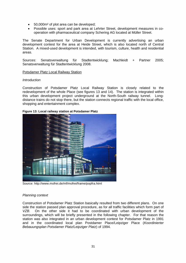
The Senate Department for Urban Development is currently advertising an urban development contest for the area at Heide Street, which is also located north of Central Station. A mixed-used development is intended, with tourism, culture, health and residential areas. Sources: Senatsverwaltung für Stadtentwicklung; Machleidt + Partner 2005; Senatsverwaltung für Stadtentwicklung 2008. Potsdamer Platz Local Railway Station Introduction Construction of Potsdamer Platz Local Railway Station is closely related to the redevelopment of the whole Place (see figures 13 and 14). The station is integrated within this urban development project underground at the North-South railway tunnel. Long-distance trains do not stop there, but the station connects regional traffic with the local office, shopping and entertainment complex. Figure 13: Local railway station at Potsdamer Platz
Source: http://www.mofrei.de/mf/mofrei/frame/popfra.html
Planning context Construction of Potsdamer Platz Station basically resulted from two different plans. On one side the station passed plan approval procedure, as for all traffic facilities which form part of VZB. On the other side it had to be coordinated with urban development of the surroundings, which will be briefly presented in the following chapter. For that reason the station was also integrated in an urban development contest for Potsdamer Platz in 1991 and in the coordinated local plan Postdamer Place/Leipziger Place (Koordinierter Bebauungsplan Potsdamer Platz/Leipziger Platz) of 1994.
32
Proposed development and key features Potsdamer Platz (together with the adjacent Leipziger Place) was an important part of Berlin‟s inner city in the early 20th century. It became less important in the course of the Second World War and during the separation of the city, like almost of the border area between East and West Berlin. Revitalization of the Place began after German Reunification, and during the 1990s it was one of the largest construction sites in the city. Potsdamer Platz consists of five urban development projects (see figure 11). The DaimlerChrysler Quarter has been developed by former Daimler-Benz AG and was completed in 1998. The State of Berlin sold the building ground to the company in the early 1990s. Key features of the project are:
An estimated 100,000m² of plot area;
500,000m² of floor space;
19 buildings, ten streets, two plazas;
Mixed-used zoning: 50% offices, 20% residential use, 30% are used by a shopping center, entertainment (cinema, theatre) and hotels;
An estimated 70,000 – 100,0000 visitors daily;
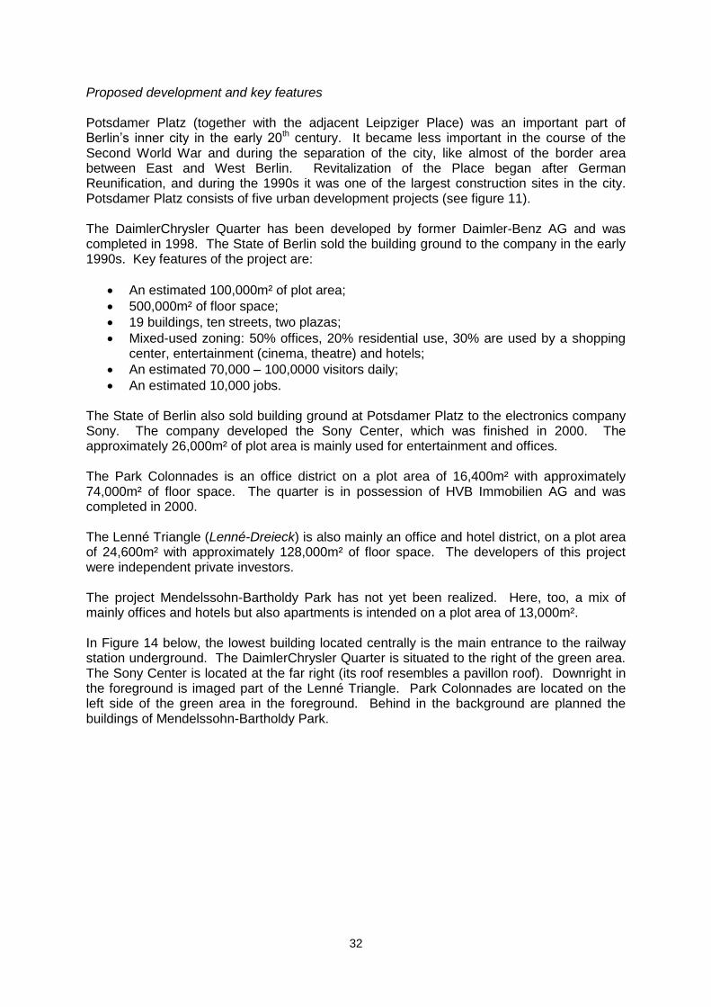
An estimated 10,000 jobs. The State of Berlin also sold building ground at Potsdamer Platz to the electronics company Sony. The company developed the Sony Center, which was finished in 2000. The approximately 26,000m² of plot area is mainly used for entertainment and offices. The Park Colonnades is an office district on a plot area of 16,400m² with approximately 74,000m² of floor space. The quarter is in possession of HVB Immobilien AG and was completed in 2000. The Lenné Triangle (Lenné-Dreieck) is also mainly an office and hotel district, on a plot area of 24,600m² with approximately 128,000m² of floor space. The developers of this project were independent private investors. The project Mendelssohn-Bartholdy Park has not yet been realized. Here, too, a mix of mainly offices and hotels but also apartments is intended on a plot area of 13,000m². In Figure 14 below, the lowest building located centrally is the main entrance to the railway station underground. The DaimlerChrysler Quarter is situated to the right of the green area. The Sony Center is located at the far right (its roof resembles a pavillon roof). Downright in the foreground is imaged part of the Lenné Triangle. Park Colonnades are located on the left side of the green area in the foreground. Behind in the background are planned the buildings of Mendelssohn-Bartholdy Park.
33
Figure 14: View onto Potsdamer Platz
Source:http://www.stadtentwicklung.berlin.de/planen/staedtebau-projekte/leipziger_platz/de/realisierung/index.shtml
Sources: Cire, A. 2006; DaimlerChrysler Real Estates 2007; Deutsche Bahn (DB); Senatsverwaltung für Bau- und Wohnungswesen 1994; HVB Immobilien AG 2007; Senatsverwaltung für Stadtentwicklung: Städtebauliche Projekte. Leipziger und Potsdamer Platz; Sony Berlin GmbH 2008. Gesundbrunnen Station and Southern Cross Gesundbrunnen Station and Southern Cross are two more travel nodes along the Berlin North-South rail link. These stations are not part of the VZB project but are nevertheless important nodes in Berlin‟s transport infrastructure. For that reason further information about Gesundbrunnen Station and Southern Cross can be found in the appendix of this document. Project costs
VZB had to deal with escalating costs in the course of the planning and implementation phase as many other mega urban transport projects. Cost overruns derived from factors such as rising construction prices and unforeseen events, a tunnel flood near Landwehr Canal for instance. The complex structure of the VZB project, due to integration of different means of transportation and to the large number of parties involved, also complicates the description of costs in detail. In general very little information about project costs is open to the public, especially reliable numbers are rare. The development of costs is described below as far as it is possible at this point in time of the case study. Construction costs Transport node Berlin (Knoten Berlin)
Predicted investment costs 1991: EUR 5.113bn (DEM 10bn);
Total costs 2006: EUR 6.333bn (adjusted for inflation 2006).
34
These costs include, besides other mushroom railway concept projects, the costs of the North-South connection for the long-distance railway, Berlin Central Station, Potsdamer Platz local railway station and Southern Cross. They make up the largest part of the full costs. Sources: Bundesministerium für Verkehr, Bau und Stadtentwicklung 2007; Der Bundesminister für Verkehr 1992. North-South Connection only
Predicted investment costs before start of construction: approx. EUR 2bn;
Total costs 2006: approx. EUR 3.1bn. These are the costs for the long-distance railway connection including the tunnel construction, Berlin Central Station, Potsdamer Platz local railway station and Southern Cross. Source: Bundesministerium für Verkehr, Bau und Stadtentwicklung 2006. Tunnel Tiergarten Spreebogen (road)
no data found for predicted investment costs;
Total costs 2006: approx. EUR 390m. Source: Senatsverwaltung für Stadtentwicklung 2006a. City railway S21
Predicted investment costs for the track section from northern city railway loop to Berlin Central Station 1999: approx. EUR 59m (DEM 116m);
Predicted investment costs for completion of the whole North-South route 2006: approx. EUR 200m.
Sources: Die S21 rollt – und wird für 200 Millionen neu gebaut. In: Tagesspiegel June 22, 2006; Grünes Licht für die neue Nord-Süd-Bahn. Senat will Geld für S21 bis zum Lehrter Bahnhof auslegen. In: Berlin Zeitung November 2, 1999. Metro U55
No data found for predicted investment costs;
Cost estimate 2007: EUR 370m;
Cost estimate U55 extension to Alexander Place (U5) starting 2010: EUR 400m. Sources: Kanzler-U-Bahn fährt erst im Jahr 2009. In: Welt Online May 3, 2007; Planspiele für Tempelhof. Merkel und Wowereit sprechen über den Airport – angeblich interessieren sich Investoren für ihn. In: Berliner Zeitung November 14, 2006. Construction cost time line The description of project cost development over time is not possible. Publicly available information about VZB costs is rare and not sufficient for creating a complete construction cost timeline.
35
Project delivery Table 5: Overview of project delivery
Forecast Actual
Construction start Long-distance railway tunnel
1995 1995
Tunnel Tiergarten Spreebogen (road)
1995 1995
Tunnel metro U55 - Start of construction together with construction works in government district, main construction works since 2004
Tunnel city railway line S21
- Some parts of S21 have been constructed within the long-distance railway project. Main construction works have not started yet
Completion Long-distance railway tunnel
2002 2006
Tunnel Tiergarten Spreebogen
2002 2006
Tunnel metro U55 2009 (has been modified several times)
-
Tunnel city railway line S21
2011-2013 (has been modified several times)
-
Commencement of use
Long-distance railway tunnel
2002 2006
Tunnel Tiergarten Spreebogen
2002 2006
Tunnel metro U55 2009 2009
Tunnel city railway line S21
2011-2013 -
Source: Preuß, E. 2006: pp. 157-159.
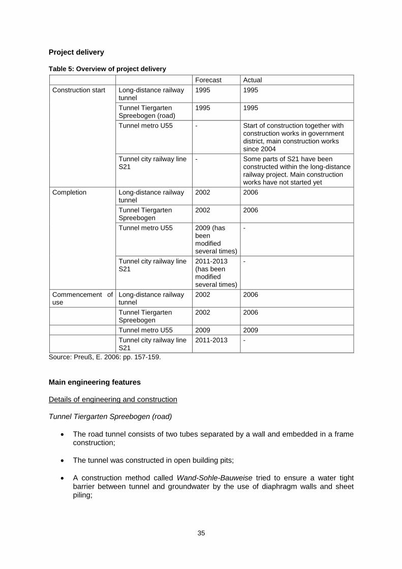
Main engineering features Details of engineering and construction Tunnel Tiergarten Spreebogen (road)
The road tunnel consists of two tubes separated by a wall and embedded in a frame construction;
The tunnel was constructed in open building pits;
A construction method called Wand-Sohle-Bauweise tried to ensure a water tight barrier between tunnel and groundwater by the use of diaphragm walls and sheet piling;
36
Crossing of the River Spree was a challenging sub-building pit not only for the Tunnel Tiergarten Spreebogen project but also for all VZB tunnels. For that reason the riverbed was diverted during the construction phase;
A further special zone was the tunnel construction below Berlin Central Station. Special structural solutions were necessary in this area due to a thirteen-floor high superstructure above the road tunnel.
Source: Senatsverwaltung für Stadtentwicklung 2006a. Long-distance railway tunnel
Construction methods for the four-track railway tunnel differed in the sub-sections:
The tunnelling shield method was used for two sections called tunnel structure north (705m) and south (574m);
Open building pits including the above-mentioned Wand-Sohle-Bauweise were applied at Place of the Republic (119m) and Potsdamer Platz (261m);
A third technique was used at Lenne-Triangle (201m) and Railway Triangle (319m): tunnel segments were constructed above surface and were then flushed into the ground (this method is called Druckluft-Senkkastenverfahren).
Source: Azer, H. 2006a. Metro tunnel U55 The U55 will be built in five construction phases. The main building pit is situated at Unter den Linden:
Phase 1: Demolition of urban railway passageway at Unter den Linden station in an open building pit;
Phase 2: Construction of subterraneous curtains east and west of Wilhelm Street to protect the tunnel structure from groundwater. Open building pit;
Phase 3: Preparation of an initial pit for the tunnelling works located at Pariser Place;
Phase 4: Digging the ducts by the tunnelling shield method. Shotcrete Lining;
Phase 5: Construction of a new western exit at Unter den Linden;
Phase 6: Construction of a new eastern exit at Unter den Linden. Source: Berliner Verkehrsbetriebe (BVG): The future U55. Construction. Details of main contracts For engineering contracts of all VZB sub-projects see section on „Contractors‟ above.
37
Main Engineering Key Facts and Figures Facts and Figures Tunnel Tiergarten Spreebogen (road) Table 6: Facts and figures Tunnel Tiergarten Spreebogen
Distance
2.9km from Invalidenstreet to Landwehr Canal
Quantities building pit
Number of sub-building pits: 32
Excavated soil above groundwater: 190,000m³
Excavated soil in groundwater: 700,000m³
Backfill: 350,000m³
Diaphragm walls for building pit walls: 65,000m²
Tie rods (I = 15m): 34,000m
Sub aqueous concrete foot wall: 70,000m³
Levelling course for sub aqueous concrete foot wall: 50,000m³
Counter-uplift anchors for sub aqueous concrete foot wall: 115,000m
Low-lying impermeable foot wall: 20,000m³
Groundwater lowering (pumping out): 710,000m³
Quantities tunnel equipment
Power cables: 650km
10kV transformers: six
Exhaust air fans: seven
Supply air fans: one
Jet fan ventilators: 74
Traffic data interfaces: 43
Route stations: 62
Variable lane signals with LED-indicator lights: 228
Variable traffic signs: 31
Fibre-optical permanent light signals: 158
Tunnel lights: 800
Escape route lights: 245
Standby lights in case of fire: 245
Tunnel loudspeakers: 500
Security colour cameras: 150
Emergency telephones: 41
Quantities tunnel
Concrete: 190,000m³
Steel: 20,000t
Drainage lines: 2,600m
Asphalt road surface: 60,000m²
Emergency footway 10,000m
Performance
Expected traffic volume: 50,000 vehicles/day
Actual traffic volume 2007: 44,000 vehicles/day
Costs
Total costs: approx. EUR 390m
Sources: Senate Department for Urban Development: Streets for Berlin. B96 – Facts and figures; Senatsverwaltung für Stadtentwicklung 2007.
Facts and figures long-distance railway tunnel: Distance: 3.5km from Döberitzer Street to Southern Cross. Sections (including gateway areas):
Central Station (1100m);
Spree River loop (501m);
Tiergarten Park (827m);
Potsdamer Platz and Lenné-Triangle (459m);
Landwehr Canal (1164m). Performance: Maximum usage: six trains per hour in each direction. For journey times from Berlin to selected German destinations before and after opening of the North-South connection see table 7.
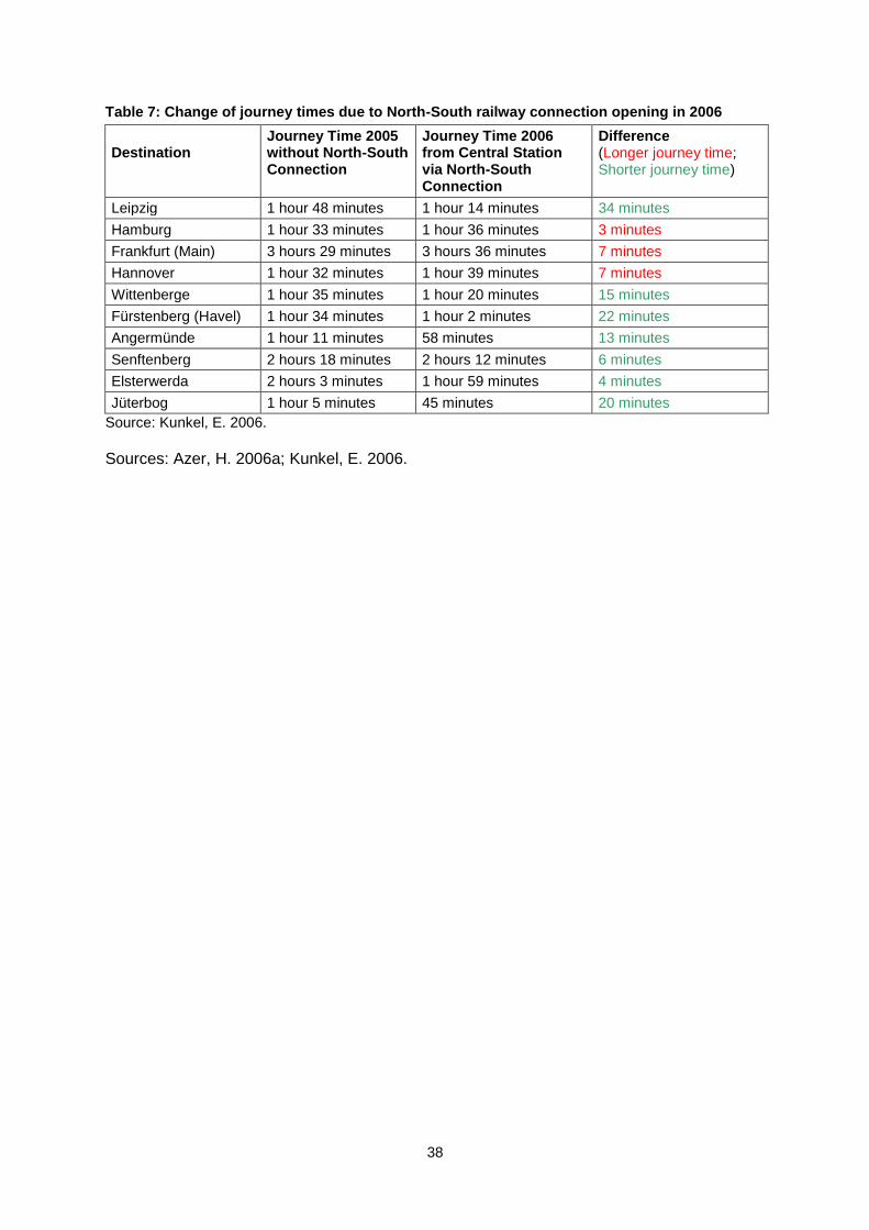
38
Table 7: Change of journey times due to North-South railway connection opening in 2006
Destination
Journey Time 2005 without North-South Connection
Journey Time 2006 from Central Station via North-South Connection
Difference (Longer journey time; Shorter journey time)
Leipzig 1 hour 48 minutes 1 hour 14 minutes 34 minutes
Hamburg 1 hour 33 minutes 1 hour 36 minutes 3 minutes
Frankfurt (Main) 3 hours 29 minutes 3 hours 36 minutes 7 minutes
Hannover 1 hour 32 minutes 1 hour 39 minutes 7 minutes
Wittenberge 1 hour 35 minutes 1 hour 20 minutes 15 minutes
Fürstenberg (Havel) 1 hour 34 minutes 1 hour 2 minutes 22 minutes
Angermünde 1 hour 11 minutes 58 minutes 13 minutes
Senftenberg 2 hours 18 minutes 2 hours 12 minutes 6 minutes
Elsterwerda 2 hours 3 minutes 1 hour 59 minutes 4 minutes
Jüterbog 1 hour 5 minutes 45 minutes 20 minutes
Source: Kunkel, E. 2006.
Sources: Azer, H. 2006a; Kunkel, E. 2006.
39
D PROJECT TIMELINE
Year Month Type of decision/event
Key decision/event
1990 Oct Project Initiation DE-Consult, a former joint undertaking of German Federal Railways and Deutsche Bank, presented the idea of a new Berlin railway concept within a railway colloquy at Logenhaus Conference Center, Berlin
6.
1991 Apr Project Initiation/Financing
Resolution of Federal Government on „Transport Projects German Unity‟ (Verkehrsprojekte Deutsche Einheit). Project no. 8.3: investments in railroad connection from Berlin to Leipzig/Halle including Berlin Central Station Hub
8.
1991 June Project Initiation Hauptstadt-Beschluss: „Capital Resolution‟ of the German Bundestag: Berlin becomes capital and seat of the German Government. This decision was the main basis for the VZB project‟s initiation
8.
1991 Dec Project Initiation Resulting from the „Capital Resolution‟ the Berlin Senate passed a resolution on an integrated basic concept of traffic planning for the central area (Grundlinien der Verkehrsplanung im zentralen Bereich) including considerations about an inner city road tunnel
7.
1992 Mar Project Initiation Leaders of German Federal Railways (Dürr and Münchschwander) and East German Railways (Remmert) presented the Federal Transport Minister (Krause) with their mushroom railway concept for Berlin (North-South-Connection). Krause agreed with the plans
8.
1992 July Project Initiation The Federal Government advocated plans for the Berlin mushroom railway concept
8.
1992 July Project Initiation/Financing
On the basis of the German Federal Transport Infrastructure Plan 1992 (Bundesverkehrswegeplan 1992) the Federal Ministry of Transport (Bundesministerium für Verkehr) instructed the Government of Berlin and East German Railways (Deutsche Reichsbahn) to submit a joint plan for the transport facilities in the central area
8.
1992 Sept Node Berlin Central Station
East German Railways commissioned the architects Kleihues and Gerkan to conduct project studies for the planned Central Station
6.
1992 - Node Potsdamer Platz
An early civic participation procedure (vorgezogene Bürgerbeteiligung) for the land use plan Berlin and coordinated local plan Potsdamer Platz/Leipziger Place. 1,300 objections to the road tunnel
3.
1993 Feb Node Berlin Central Station
Media conference by the Berlin Senate and East German Railways: Presentation of project studies Berlin Central Station
6.
1993 Mar Node Berlin Central Station
East German Railways decided on the Berlin Central Station design by architect Gerkan
6.
1993 Autumn Project Initiation The Federal Ministry of Transport, State of Berlin and German Railways establish a planning team responsible for the transport facilities in the central area (Projektgesellschaft für die Planung der Verkehrsanlagen im Zentralen Bereich Berlin – PVZB): plan approval procedure (Planfeststellungsverfahren – PFV)
8.
1993 Nov Problem project Initiation
Resolution of Berlin Senate not to build city railway line S21 at the moment due to financial straits
5.
1993 - Pressure Group Foundation of „Anti-Tunnel GmbH‟, which disagreed with the tunnel plans
3.
40
Year Month Type of decision/event
Key decision/event
1993 - Project Initiation Public display of the land use plan Berlin. 19,000 objections to the traffic planning including tunnel constructions
3.
1994 - Project Initiation The land use plan Berlin considered VZB tunnels3.
1995 - Project Initiation Public display within the VZB plan approval procedure3.
1995 Sept Project Initiation Plan approval decision (Planfeststellungsbeschluss) from the Federal Railway Authority (Eisenbahn-Bundesamt – EBA) for the transport facilities in the central area
8.
1995 Oct Implementation Groundbreaking ceremony of the VZB project in the presence of Federal Chancellor Helmut Kohl, Federal Transport Minister Matthias Wissmann, Chairman of German Railways Heinz Dürr and the mayor of Berlin Eberhard Diepgen
6.
1995 Nov Implementation Official start of construction road Tunnel Tiergarten Spreebogen
6.
1995 Nov Pressure Group „Anti-Tunnel GmbH‟ took legal action against plan approval decision before the Federal Administrative Court
3.
1996 Apr Node Berlin Central Station
First building pits of Berlin Central Station were assigned to building enterprises
6.
1996 - Presssure Group Legal action against plan approval decision dismissed3.
1996 - Implementation A section of the Spree riverbed was diverted for VZB tunnel construction
6.
1997 July Problems Implementaion
Flooding of a tunnel section near Landwehr Canal caused project delays
6.
1997 Aug Financing Finance agreement between German Railways and Federal Government for the North-South railway connection. Federal Government provides EUR 1.728bn of the approx. EUR 2bn for the entire project. The own resources of German Railways amounted to EUR 500m
6.
1998 Sept Node Berlin Central Station
Groundbreaking ceremony Berlin Central Station in the presence of Federal Transport Minister Matthias Wissmann, the mayor of Berlin Eberhard Diepgen, and German Railways chairman Johannes Ludewig
6.
1998 - Financing European Union grants for the long-distance railway tunnel within Trans-European Network project (TEN-T): approx. EUR 75m
8.
1999 Nov Financing Berlin Senate provided financing for the northern section of city railway line S21 between Northern city railway loop and Central Station
9.
1999 - Project Initiation Plan approval decision metro line U51.
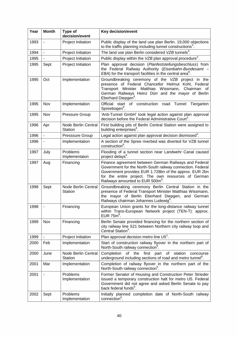
2000 Feb Implementation Start of construction railway flyover in the northern part of North-South railway connection
6.
2000 June Node Berlin Central Station
Completion of the first part of station concourse underground including sections of road and metro tunnel
6.
2001 Mar Implementation Completion of railway flyover in the northern part of the North-South railway connection
6.
2001 - Problems Implementation
Former Senator of Housing and Construction Peter Strieder issued a temporary construction halt for metro U5. Federal Government did not agree and asked Berlin Senate to pay back federal funds
6.
2002 Sept Problems Implementation
Initially planned completion date of North-South railway connection
6.
41
Year Month Type of decision/event
Key decision/event
2002 Oct Node Berlin Central Station
Start of last building pit Berlin Central Station6.
2003 June Implementation Start of concreting road tunnel6.
2003 Dec Node Southern Cross
Start of conversion Southern Cross6.
2005 Feb Implementation Plan approval decision city railway line S216.
2005 June Node Southern Cross
Opening new station concourse Southern Cross6.
2005 Summer Project Initiation Decision of Federal Government to fund city railway line S21
6.
2006 Mar Implementation Opening road Tunnel Tiergarten Spreebogen6.
2006 May Implementation Opening of North-South connection including Berlin Central Station, Gesundbrunnen Station, Potsdamer Platz Local Railway Station and Southern Cross
6.
2007 Mar Financing Several members of German Parliament complained about cost overruns of railway node extension Berlin (North-South railway tunnel including transport nodes)
4.
2007 Apr Financing Federal Ministry of Transport, Building and Urban Affairs included further financial requirements for completion of North-South railway connection within railway infrastructure investment plan until 2010: EUR 200.8m during 2006-2010, EUR 349.9m after 2011
2.
Sources: 1.Berliner Verkehrsbetriebe: U55. Brandenburger Tor als U-Bahn-Shuttle; 2.Bundesministerium für Verkehr, Bau und Stadtentwicklung 2007; 3.Bürgerinitiative Westtangente: Chronik; 4.Deutscher Bundestag 2007; 5.Peters, D. 2008b: p. 4; 6.Preuß, E. 2006; 7.Senatsverwaltung für Verkehr und Betriebe Berlin 1995; 8.Waßmuth, W.; Baufeld, M. 2006; 9.Grünes Licht für die neue Nord-Süd-Bahn. Senat will Geld für S21 zum Lehrter Bahnhof auslegen. In: Berliner Zeitung November 2, 1999. Project timeline key issues
The following key issues emerge from the project timeline: Project initiation: Ambitious plans for Berlin after German Unity – a special case of MUTP Arising from German Unity, the VZB project can be regarded as a special case of MUTP. The fall of the Berlin Wall was a unique opportunity for planners to broadly reconnect the city‟s infrastructure, which was interrupted for almost 30 years. Shortly after 1989/1990 most people had very optimistic expectations for the economic and population development of Berlin (which had to be revised downwards later on – for more details see Peters 2008b: 3). In addition, politicians decided to relocate the Federal Government from Bonn to Berlin. All this required corresponding infrastructure development. Under these very special circumstances optimistic visions of the future seemed to be much more important than bald comparisons of costs and benefits of a mega urban transport project. It might also explain the relatively short VZB project initiation phase from 1992 to 1995. Project initiation: Mushroom railway concept as pivotal element in a mega project bundle Looking at the entire VZB project is often very confusing due to the integration of different subprojects and different means of transportation. After getting a general idea of the entire
42
mega project bundle the dominance of the mushroom railway concept becomes apparent. The North-South railway connection and its stations, especially the newly built Central Station, were the centrepiece of the entire transport facilities for the central area. Other parts of the project - the road tunnel, the city railway line S21 and the metro line U5 – are appended to the railway concept and would not have been implemented on their own. A closer view of these appended projects shows that all were quite long-standing ideas. The redevelopment of Berlin‟s transport infrastructure after 1989 can be understood as the right time for also promoting these old ideas. But bundling the subprojects together in a joint approval procedure turned out to be problematic, because path dependencies and a „point of no return‟ for all VZB projects were created at an early stage. In this way, also, questionable subprojects were pushed through. Public resistance especially against the road tunnel, the subsequent financial straits of the Berlin Senate and the moderate economic and population development of the city were subordinated to the plan approval decision once made. Implementation: Complicated and risky project coordination The engineering and coordination of the VZB tunnel construction was marked by many difficulties that caused delays. The first important issue in this context is the Spree River and the high groundwater level in Berlin‟s inner city. Diversion of the Spree Riverbed and groundwater monitoring complicated the implementation of the VZB project. A tunnel section near Landwehr Canal flooded. Secondly, various tunnel construction methods were used, from open building pits to the tunnelling shield method. All these had to be coordinated and some were used under urban circumstances for the first time. Thirdly, almost the entire inner city near the former Berlin Wall was affected by VZB and urban development construction works. Providing all construction sites with building material and the disposal of excavated soil was a logistical challenge. Transport nodes: urban development projects, festivalization and privatization Due to the redevelopment of Post-Wall Berlin, urban development and the VZB projects have to be seen as a whole. In particular, the Central Station and the Postdamer Place Local Railway Station including its surroundings were and still are in the public eye. In this context the issue of festivalization has to be mentioned. The mostly state-funded VZB infrastructure was celebrated with large public opening ceremonies and was altogether a large media event. It is reminiscent of the commonly occurring festivalization of urban economic development projects implemented with the help of public-private partnerships. A second important issue is privatization and urban development. German Railways, as an organizational privatized and profit-oriented company, created the Central Station as a large shopping mall. In addition, the company partly acted as a developer within the station‟s surroundings with its former subsidiary Vivico Real Estate. Source: Peters, D. 2008b.
43
E PROJECT FUNDING
Introduction The VZB project is mainly financed with public federal funds. The Federal Government is obliged to provide German railway infrastructure according to the „Act on expansion of federal track systems‟ (Gesetz über den Ausbau der Schienenwege des Bundes – BSWAG). For that reason the North-South railway connection was mainly funded by the Federal State. Not only the long-distance railway project but also the local railway, metro and road tunnels are state-funded and partly co-financed by other involved institutions. Special finance agreements with additional stakeholders have been made for each project and subproject. Consequently, funding structures are very complex. Project funding will be described as far as possible at this point in time of the case study. Most data was found for the financing of the North-South connection for the long-distance railway. Background to funding
Revenue There are no sources with revenue forecasts and actual revenues open to the public that refer to the VZB project. Prediction of funding costs Figure 12 shows the predicted development of the finance agreement between Federal Government and German Railways from 1994 to 2005 for the largest part of the VZB project, the North-South long-distance railway connection. The bright area in the background shows the actual state of the finance agreement. The area in the middle illustrates the release of funds over the years. The anterior dark area shows the actual use of funds between 1994 and 2005. Approximately EUR 2bn of funds were appropriated in this period of time from both stakeholders.

44
Figure 15: Finance agreement for North-South railway connection between Federal Government and German Railways in EUR
(Source: Bölke, J & Schäfer, P, 2006: p. 157.)
Funding key stages
The launch part 1 – in April 1991: Federal Resolution on „Transport projects German Unity‟ (Verkehrsprojekte Deutsche Einheit) including project no. 8.3: Federal funding assurance for long-distance railroad connection from Berlin to Leipzig/Halle (including North-South railway tunnel).
The launch part 2 – in July 1992: Resolution on „German Federal Transport Infrastructure Plan 1992‟ (Bundesverkehrswegeplan 1992). In this document „Transport projects German Unity‟ and „Act on expansion of federal track systems‟ were considered and federal financing of the North-South long-distance railway connection was confirmed.
Problem funding S21 – in November 1993: Resolution of Berlin Senate not to build city railway line S21 at present due to financial straits.
Finance agreement – in August 1997 between German Railways and the Federal Government for the North-South railway connection. On the basis of the responsibility for the German track system the Federal Government financed EUR 1.728bn of the approximately EUR 2bn for the North-South railway connection. German Railways contributed EUR 500m from their own resources.
European Union grants – have been provided since 1998 for the long-distance railway tunnel within the Trans-European Transport Network project (TEN-T). The EU provided approximately EUR 75m for the North-South connection.
45
Funding city railway S21 – November 1999. Berlin Senate now provided financing for the northern section of city railway line S21 between the northern city railway loop and Central Station.
Funding city railway S21 – summer 2005. The Federal Government decided to finance the second part of city railway line S21. Funding is spread over a relatively long period of time, so that S21 will be completed at the earliest between 2011 and 2013.
Finance agreement – for the road tunnel between Berlin Senate and Federal Government: EUR 181m of the EUR 390m was paid by the Federal Government.
Finance agreement – for the metro tunnel U55 between Berlin Senate and Federal Government. No precise data have been found.
Complaint – March 2007. Members of the Federal Government complained about the cost overruns of the North-South railway connection.
Additional financing – April 2007 for the North-South railway connection. The Federal Ministry of Transport, Building and Urban Affairs budgeted for further financial requirements for this project: approximately EUR 300m from 2006 to 2010 and an additional EUR 349m after 2011.
Sources: Bölke, J. ; Schäfer, P. 2006; Berliner Verkehrsbetriebe (BVG): U55. Brandenburger Tor als U-Bahn-Shuttle; Bundesministerium für Verkehr, Bau und Stadtentwicklung 2007; Der Bundesminister für Verkehr 1992; Eisenbahn-Bundesamt 2005; Preuß, E. 2006: p. 49; Freie Fahrt im Tiergartentunnel. Deutschlands längste Straßenröhre soll die Berliner Innenstadt entlasten – Senat rechnet mit 50.000 Autos täglich. In: Berliner Morgenpost March 27, 2006. Traffic forecasts No appropriate data are available on the direct effects of traffic forecasts on the amount of funding for the project. For general predicted traffic volume as the basis for the initiation of the VZB project, see „Reported traffic volume‟ below. Funding sources The distribution of costs have been negotiated for each subproject, for instance for the construction of a station or a tunnel section. So-called „keys of cost distribution‟ (Kostenteilungsschlüssel) have been developed for this purpose. The main funding sources are the following, almost exclusively public, institutions (arranged according to the estimated amount of investment):
Institution Sector
Federal Government/Federal Ministry of Transport Public
German Railways Public/privatized organizationally in the form of a stock corporation
Berlin Senate Public
European Union Public
Berlin Transport Authority Public
46
Commentary on financing/funding To put it briefly: Firstly VZB funding was and still is provided from public sources, mainly from the Federal Government, except for funding from German Railways, which is a privatized but still state-owned stock company. Secondly VZB funding was very complex due to the numerous subprojects with separate funding structures. For that reason a transparent breakdown of all funding sources seems an impossible task. Thirdly project funding was characterized by the financial straits of the Berlin Senate, which caused delays in implementation of the city railway line S21 and metro line U55.

47
F OPERATIONS
Reported traffic volume Table 8: Overview of reported traffic volume
Predicted traffic volume Actual traffic volume
Long-distance railway traffic Berlin
Predicted in 1992 for the year 2010:
53m passengers per year to and from Berlin
5.3m transit passengers per year
107 trains per day passing through North-South connection
Actual traffic volume:
six trains per hour in each direction passing through North-South tunnel = 288 trains per day (including regional railway traffic)
An estimated 300,000 passengers daily (to and from Central Station including East-West railway connection and visitors)
Regional railway traffic Berlin
Predicted in 1992 for the year 2010:
76-88m passengers per year between Berlin and the surroundings of the city
plus traffic within Berlin and within the surroundings: 90-101m passengers per year
84 trains per day passing through North-South connection
60 trains per day airport express to mayor airport
Actual traffic volume:
see above long-distance traffic
Cars and trucks in road Tunnel Tiergarten Spreebogen
Predicted in 1994:
60,000 motor vehicles per day passing the road tunnel Predicted in 2006 shortly before opening:
50,000 motor vehicles/day
Actual traffic volume in 2007:
44,000 vehicles/day
Passengers Metro U55 Predicted in 1994:
32,200 passengers per day using the metro line U5 (extended to Alexander Place) from Berlin Central Station instead of individual motor cars or taxis Predicted around 2004:
64,000 passengers per workday using the U55 from Central Station
The Metro line U55 has not been put into operation yet
Passengers city railway line S21
No information available The city railway line S21 has not been put into operation yet
Sources: Berliner Verkehrsbetriebe (BVG): Building for the Future. Extension of the U5. ; Der Bundesminister für Verkehr 1992. ; Deutsche Bahn; Senatsverwaltung für Bau- und Wohnungswesen 1994: pp. 22, 34, 39. ; Deutsche Bahn (DB) 2005.; Münchschwander, P.; Remmert, W.; Funk, D. 2006; Projektgesellschaft für Verkehrsanlagen im Zentralen Bereich Berlin mbH (PVZB) 1994b; Senatsverwaltung für Stadtentwicklung Berlin 2006a; Senatsverwaltung für Stadtentwicklung 2007.

48
How traffic forecasts were formulated
Traffic predictions for the long-distance railway project were formulated by the Federal Ministry of Transport in 1992 on the basis of a general traffic forecast for 2010. Thereof operating programmes for future regional and long-distance railway traffic were derived (for data see previous chapter) and the mushroom railway concept was promoted as the means of building an adequate transport infrastructure for the predicted traffic development. Traffic volume forecasts for the road and metro tunnel were formulated within the VZB plan approval procedure in 1994 and based on local data from the Berlin Senate. The unique situation in Berlin shortly after 1989/1990 must once more be emphasised. The very optimistic expectations for economic and population development are reflected in the traffic forecasts from the early 1990s and had to be revised downwards to some degree later on.
49
G BIBLIOGRAPHY Azer, Hany (2006a): Von Senkkasten, Schildvortrieb und Spreeverlegung. In: Waßmuth, W.; Baufeld, M. (2006): Bahnmetropole Berlin. Die neue Nord-Süd-Verbindung: pp. 54-65. Azer Hany (2006b): Besonderheiten der Schilddurchfahrt durch den Berliner Untergrund. In: Waßmuth, W.; Baufeld, M. (2006): Bahnmetropole Berlin. Die neue Nord-Süd-Verbindung: pp. 66-70. Bauzeitung Tempelhof-Schöneberg Nr.4 (2006): Stadtumbau Berlin. Schöneberg-Südkreuz [online]. Available from: http://www.berlin.de/imperia/md/content/batempelhofschoeneberg/abtgesstadtqm/plangendenk/planen/2006_01_23_bauzeitung4_stadtumbau_west.pdf [cited 10 April 2008]
Berliner Landesarbeitsgemeinschaft Naturschutz (BLN); Anti-Tunnel-GmbH (1994): Eigentlich spricht alles gegen die Tiergartentunnel…. Redaktionell überarbeitete Fassung der Stellungnahme zu den „Verkehrsanlagen im Zentralen Bereich“. Berliner Verkehrsbetriebe (BVG): Bauchronologie und Bilder [online]. Available from: http://www.bvg.de/index.php/de/Bvg/GalleryDetail/id/160844/key/16/folder/1270/gallery/160843/rewindaction/Detail/rewindmodule/Bvg/rewindid/160844 [cited 19 May 2008) Berliner Verkehrsbetriebe (BVG): Building for the Future. Extension of the U5. The U55 Shuttle Line from Hauptbahnhof to the Brandenburg Gate [online]. Available from: http://www.u55.info/en_u55/start.htm [cited 6 February 2008] Berliner Verkehrsbetriebe (BVG): The future U55. Construction [online]. Available from: http://www.bvg.de/index.php/en/Bvg/Index/folder/1275/name/Construction [cited 28 April 2008) Berliner Verkehrsbetriebe (BVG): U55. Brandenburger Tor als U-Bahn-Shuttle [online]. http://www.bvg.de/index.php/de/Bvg/Detail/folder/1015/rewindaction/Index/id/131076/name/Brandenburger+Tor+als+U-Bahn-Shuttle [cited 30 April 2008] Berliner Verkehrsbetriebe (BVG): Unsere Links + Partner [online]. Available from: http://www.u55.info/u55/links.htm [cited 18 March 2008]
Bölke, J.; Schäfer, P. (2006): Kernaufgaben des Eisenbahn-Bundesamtes am Beispiel des Bahnknoten Berlin. In: Bahnmetropole Berlin. Die neue Nord-Süd-Verbindung: pp. 148-158. Bürgerinitiative Westtangente: Chronik [online]. Available from: http://www.bi-westtangente.de/context.php?action=chronik [cited 11 March 2008] Bundesministerium für Verkehr, Bau und Stadtentwicklung (2006): Die neue Nord-Süd-Verbindung in Berlin [online]. Available from: http://www.bmvbs.de/dokumente/-,302.4813/Artikel/dokument.htm [cited 16 April 2008] Bundesministerium für Verkehr, Bau und Stadtentwicklung (2007): Investitionsrahmenplan (Fünfjahresplan) für den Ausbau der Schienenwege des Bundes bis 2010 – Projektliste und Erläuterungen -: p. 2 [online]. Available from: http://www.bmvbs.de/Anlage/original_1003308/Investitionsrahmen-plan-bis-2010-fuer-die-Verkehrsinfrastruktur-des-Bundes-IRP.pdf [cite 16 April 2008]

50
Bundesverwaltungsgericht (1995): (Erstinstanzlicher) Beschluss des Bundesverwaltungsgerichts vom 28.11.1995 – 11 VR 38.95 – (Tiergartentunnel Berlin) [online]. Available from: http://www-penelope.drec.unilim.fr/penelope/Library/Libs/DLib/11VR38/11VR38.htm [cited 31 March 2008] Braun, M. (2004): Neue Berliner S-Bahn-Strecke S21, Planungsstand und Realisierungschancen. In: EI – Eisenbahningenieur (55) 11/2004. Cire, A. (2006): Work in Progress: der Regionalbahnhof Potsdamer Platz [online]. Available from: http://www.mofrei.de/mf/mofrei/kontext/kon_bau.html [cited 10 April 2008] DaimlerChrysler Real Estates (2007): Welcome to Potsdamer Platz [online]. Available from: http://www.potsdamerplatz.de/en/daimlerchrysler_quartier_potsdamer_platz.html [cited 9 April 2008] DB Infrastruktur Personenbahnhöfe (2006): Der neue Berliner Hauptbahnhof [online]. Available from: http://www.hbf-berlin.de/site/shared/de/dateianhaenge/infomaterial/sonstige/poster__berlin__hauptbahnhof__juni06.pdf [cited 7 April 2008] Der Bundesminister für Verkehr (1992): Bundesverkehrswegeplan 1992. Deutsche Bahn (DB); Senatsverwaltung für Bau- und Wohnungswesen (1994): Verkehrsanlagen im zentralen Bereich Berlin. Erläuterungsbericht Planfeststellungsbereich Bau-FB-km 1,7 + 52N bis Bau FB-km 7,7 +77. Deutsche Bahn –DB (2007): Der Hauptbahnhof in Zahlen. 300.000 Reisende und Besucher werden täglich erwartet [online]. Available from: http://www.hbf-berlin.de/site/berlin__hauptbahnhof/de/kundenzentrum__bahnhof/daten__und__fakten/daten__und__fakten.html [cited 7 April 2008] Deutsche Bahn (DB) (2007): Berlin Südkreuz. Daten und Fakten [online]. Available from: http://www.bahnhof.de/site/bahnhoefe/de/ost/berlin__suedkreuz/daten__und__fakten/daten__und__fakten.html [cited 14 April 2008] Deutscher Bundestag: Drucksache 13/2668 vom 12.10.1995. Verkehrsplanung Hauptstadt Berlin und Region Berlin-Brandenburg, point 3 [online]. Available from: http://dip.bundestag.de/btd/13/026/1302668.asc [cited 11 March 2008] Deutscher Bundestag Drucksache 16/4783 (2007): Antwort der Bundesregierung auf die Kleine Anfrage der Abgeordneten Dr. Anton Hofreitner, Winfried Hermann, Peter Hettlich, weiterer Abgeordneter und der Fraktion BÜNDNIS 90/DIE GRÜNEN – Drucksache 16/5412- Kostenüberschreitungen bei Bauprojekten der Deutschen Bahn AG [online]. Available from: http://dip.bundestag.de/btd/16/047/1604783.pdf [cited 29 April 2008] Die Bahn (DB) (2001): Drehscheibe Berlin. Pilzkonzept [online]. Available from: http://www.bahn.de/imperia/md/content/pdf/holding/bauprojekte/3.pdf [cited 5 February 2008]. Die Bahn (DB) (2005): Bahnverkehr Berlin 2006. Pressekonferenz 6.Juli 2005 [online]. Available from: http://www.berlinverkehr.com/netze/050706_bahnknoten__berlin__praesentation.pdf [cited 25 February 2008]
51
Eisenbahn-Bundesamt (2005): Planfeststellungsbeschluss zu dem Plan der DB Netz AG für das Bauvorhaben S21 – Nordringanbindung bis Lehrter Bahnhof Berlin-Westhafen – Berlin Lehrter Bahnhof – Berlin Wedding. Available from: http://www.eisenbahnbundesamt.de/Service/files/_90_S21_Nordringanbindung.pdf [cited 25 February 2008]. European Commission (2005): Trans-European Transport Network. TEN-T priority axes and projects 2005: p.14 [online]. Available from: http://ec.europa.eu/ten/transport/projects/doc/2005_ten_t_en.pdf [cited 25 February 2008)
Feldwisch, W.; Rothe, R.; Kamitz, K. (et al) (2006): Die Nord-Süd-Verbindung – Wie organisiert der Bauherr ein solches Großprojekt? In: Waßmuth, W.; Baufeld, M.: Bahnmetropole Berlin. Die neue Nord-Süd-Verbindung: p. 39 HVB Immobilien AG (2007): Park Kolonnaden Berlin [online]. Available from: http://www.hvbimmobilien.com/projects/briefing_1000124.html [cited 9 April 2008] Koordinierungsgruppe Verkehrsanlagen im Zentralen Bereich von Berlin / Der Senat von Berlin / Deutsche Reichsbahn, Reichsbahndirektion Berlin (1992): Planung der Verkehrsanlagen im Zentralen Bereich. Information Nr. 1. Stand Oktober 1992. Kunkel, E. (2006) : Das Fahrplankonzept. In : Waßmuth, W.; Baufeld, M.: Bahnmetropole Berlin. Die neue Nord-Süd-Verbindung: p. 34 Land Berlin; Land Brandenburg (1995): Gesetz zu dem Landesplanungsvertrag vom 6. April 1995 [online]. Available from: http://www.landesrecht.brandenburg.de/sixcms/detail.php?gsid=land_bb_bravors_01.c.23640.de#22 [cited 19 March 2008] Liegenschaftsfonds Berlin (2008): Das Projekt Humboldthafen Berlin. Eine überarbeitete Studie [online]. Available from: http://www.liegenschaftsfonds-berlin.de/site/fileadmin/user_upload/bilder/Teaserbox_rechts/Humboldthafen/humboldthafen.pdf [cited 2 April 2008] Münchschwander, P.; Remmert, W.; Funk, D. (2006): Entwicklung des Pilzkonzeptes. Überblick über die Bauvorhaben im Knoten Berlin. In: Waßmuth, W.; Baufeld, M.: Bahnmetropole Berlin. Die neue Nord-Süd-Verbindung: pp. 24-29. Peters, D. (2008a): Decision-Making for Mega-Urban Transport Infrastructure Projects: A German Case Study, Omega Project 2: Mega-Urban Transport Projects: Lessons for Decision-Makers German Country Team, Working Paper 1: National Context (forthcoming): pp. 11-12. Peters, D. (2008b): Digging through the Heart of Reunified Berlin: Unbundling the Story of the Tiergarten-Tunnel Mega-Project. Paper for the Special Session on Large Infrastructure Projects, International Conference on Infrastructure Systems “Building Networks for a Brighter Future” November 10-12, Rotterdam, The Netherlands (forthcoming): p. 4. Preuß, Erich (2006): Berlin Hauptbahnhof. Projektgesellschaft für Verkehrsanlagen im Zentralen Bereich Berlin (PVZB) (ed.) (1994a): Umweltgeologie und Umwelttechnik. Information Nr. 3. Stand Juni 1994.
52
Projektgesellschaft Verkehrsanlagen im Zentralen Bereich Berlin mbH (ed.) (1994b): Verkehrsanlagen im Zentralen Bereich im Rahmen der Planfeststellung. Information Nr. 5. Stand Juni 1994. Punkt 3 (2006a): Größter der Region: DB Service Store am Bahnhof Gesundbrunnen. No 2/2006 [online]. Available from: http://www.punkt3.de/ [cited 15 April 2008) Punkt 3 (2006b): Bahnhof Gesundbrunnen - das Tor zum Norden. No 9/2006 [online]. Available from: http://www.punkt3.de/ [cited 15 April 2008) Schröder, R. ; Barsig, M. (2004): Recherchen zur Umsetzung der Ausgleichs- und Ersatzmaßnahmen zu den planfestgestellten Vorhaben im “Zentralen Bereich” von Berlin [online]. Available from: http://www2.tu-berlin.de/zek/kubus/publikationen/Ausgleich_Zentral_Internet.pdf [cited 11 March 2008] Senate Department for Urban Development: Streets for Berlin. B96 – Facts and figures [online]. Available from: http://www.stadtentwicklung.berlin.de/bauen/strassenbau/en/tts_zahlen.shtml [cited 23 April 2008] Senatsverwaltung für Stadtentwicklung (1994): Flächennutzungsplan Berlin 1994 [online]. Available from: http://www.stadtentwicklung.berlin.de/planen/fnp/de/historie/8_FNP_1994_gr.pdf [cited 19 March 2008] Senatsverwaltung für Stadtentwicklung (2006a): Tunnel Tiergarten Spreebogen -TTS-. Stadtstraßentunnel unter dem Tiergarten im Zuge der B96 [online]. Available from: http://www.stadtentwicklung.berlin.de/bauen/strassenbau/download/Brosch_TT.pdf [cited 5 February 2008]. Senatsverwaltung für Stadtentwicklung Berlin (2006b): Tunnel Tiergarten Spreebogen –TTS-. Verkehrsfreigabe Stadtstraßentunnel im Zuge der B96 [online]. Available from: http://www.stadtentwicklung.berlin.de/bauen/strassenbau/download/tts_faltblatt.pdf [cited 13 February 2008] Senatsverwaltung für Stadtentwicklung – Pressebox (2006c): Grußwort von Senatorin Junge-Reyer zur Eröffnung des Tiergartentunnels am 26.03.2006 [online]. Available from: http://www.stadtentwicklung.berlin.de/aktuell/pressebox/archiv_volltext.shtml?arch_0603/nachricht2208.html [cited 18 February 2008] Senatsverwaltung für Stadtentwicklung – Pressebox (2007): Ein Jahr Tiergartentunnel [online]. Available from: http://www.stadtentwicklung.berlin.de/aktuell/pressebox/archiv_volltext.shtml?arch_0703/nachricht2598.html [cited 18 February 2008] Senatsverwaltung für Stadtentwicklung - Pressebox (2008): Presseeinladung: 2. Standortkonferenz – Heidestraße [online]. Available from: http://141.15.4.17/aktuell/pressebox/archiv_volltext.shtml?arch_0802/nachricht2953.html [cited 7 April 2008] Senatsverwaltung für Stadtentwicklung: Städtebauliche Projekte. Leipziger und Potsdamer Platz [online]. Available from: http://www.stadtentwicklung.berlin.de/planen/staedtebau-projekte/leipziger_platz/index.shtml [cited 9 April 2008]
53
Senatsverwaltung für Stadtentwicklung: Stadtumbau West [online]. Available from: http://www.stadtentwicklung.berlin.de/wohnen/stadtumbau/de/west.shtml [cited 14 April 2008] Senatsverwaltung für Stadtentwicklung; Machleidt + Partner (2005): Strategien Nördlicher Cityrand. Dokumentation der Werkstattverfahrens [online]. Available from: http://www.stadtentwicklung.berlin.de/planen/stadtplanerische_konzepte/download/Doku_CityNord_gesamt.pdf [cited 7 April 2008] Senatsverwaltung für Verkehr und Betriebe Berlin (1995): Verkehrsplanung für Berlin. Materialien zum Stadtentwicklungsplan Verkehr: pp. L5-L7. Sony Berlin GmbH (2008): The Sony Center [online]. Available from: http://www.sonycenter.de/aw/Home/~b/Das_Sony_Center/?lng=en [cited 9 April 2008] Stadtforum Berlin (1993): Medienmappe. Dokumentation der 28. Sitzung des Stadtforums 2. und 3. April 1993 [online]. Available from: http://www.stadtentwicklung.berlin.de/planen/forum2020/downloads/28.pdf [cited 2 April 2008] Vivico Real Estate (2008): Lehrter Stadtquartier, Berlin [online]. Available from: http://www.vivico.de/deutsch/Immobilien/Objekte/Lehrter_Stadtquartier/Fotos_und_Plaene/index.php# [cited 7 April 2008]
Waßmuth, W.; Baufeld, M. (2006): Bahnmetropole Berlin. Die neue Nord-Süd-Verbindung Newspaper Articles Grünes Licht für die neue Nord-Süd-Bahn. Senat will Geld für S21 bis zum Lehrter Bahnhof auslegen. In: Berlin Zeitung November 2, 1999 [online]. Available from: http://www.berlinonline.de/berliner-zeitung/archiv/.bin/dump.fcgi/1999/1102/lokales/0074/index.html [cited 16 April 2008] Proviant im Pavillon. Am Bahnhof Gesundbrunnen können jetzt auch Fahrkarten gekauft werden. Viel Platz gibt es für die Kunden im „DB Service Store“ aber nicht. In: Tagesspiegel February 3, 2006 [online]. Available from: http://www.tagesspiegel.de/berlin/;art270,1925490 [cited 15 April 2008] Freie Fahrt im Tiergartentunnel. Deutschlands längste Straßenröhre soll die Berliner Innenstadt entlasten – Senat rechnet mit 50.000 Autos täglich. In: Berliner Morgenpost March 27, 2006. Available from: http://www.morgenpost.de/content/2006/03/27/berlin/819375.html [cited 14 May 2008]. Südkreuz noch nicht fertig, aber nutzbar. Der erste Fernbahnzug wird in Berlins zweitgrößten Bahnhof am 28. Mai 2006 um 6.48 planmäßig halten. In: Berliner Morgenpost May 17, 2006 [online]. Available from: http://www.morgenpost.de/content/2006/05/17/bezirke/829660.html [cited 14 April 2008] Die S21 rollt – und wird für 200 Millionen neu gebaut. In: Tagesspiegel June 22, 2006. Available from: http://www.tagesspiegel.de/berlin/;art270,2171347 [cited 16 April 2008]
54
Bau neuer S-Bahn zum Hauptbahnhof noch ungewiss. Geld für die geplante Nord-Süd-Strecke S 21 ist da. Ein Termin steht nicht fest – Senat und Bahn streiten. In: Tagesspiegel July 23, 2006 [online]. Available from: http://www.tagesspiegel.de/berlin/;art270,2186281 [cited 13 February 2008] Planspiele für Tempelhof. Merkel und Wowereit sprechen über den Airport – angeblich interessieren sich Investoren für ihn. In: Berliner Zeitung November 14, 2006 [online]. Available from: http://www.berlinonline.de/berliner-zeitung/archiv/.bin/dump.fcgi/2006/1114/lokales/0041/index.html [cited 28 April 2008] Umstrittenes Handelszentrum am Fernbahnhof genehmigt. Neubau für sechs Fachmärkte löst in Gesundbrunnen Debatten aus. Arbeiten auf ehemaligem Bahngelände sollen noch diesen Monat beginnen. In: Berliner Morgenpost Novermber 18, 2006 [online]. Available from: http://www.morgenpost.de/content/2006/11/18/bezirke/866502.html [cited 15 April 2008] Berliner Hauptbahnhof. Im Vorgarten der Bundesregierung. Am neuen Hauptbahnhof wird wieder gebaut. Als erstes entstehen dort Hotels. In: Berliner Zeitung April 10, 2007 [online]. Available from: http://www.berlinonline.de/berliner-zeitung/spezial/dossiers/berlin_hauptbahnhof/75899/index.php [cited 7 April 2008] Kanzler-U-Bahn fährt erst im Jahr 2009. In: Welt Online May 3, 2007 [online]. Available from: http://www.welt.de/berlin/article849651/Kanzler-U-Bahn_faehrt_erst_im_Jahr_2009.html [cited 16 April 2008] Container mit Gleisanschluss. Vor einem Jahr wurde auch Gesundbrunnen zum Fernbahnhof. Bis heute ist er eine Kuriosität ohne zentrales Gebäude. In: Tagesspiegel June 24, 2007 [online]. Available from: http://www.tagesspiegel.de/berlin/;art270,2327380 [cited 15 April 2008] Kongressviertel am Hauptbahnhof. Lehrter Stadtquartier: Projektentwickler Vivico setzt auf Tagungshotels. In: Berliner Morgenpost December 13, 2007 [online]. Available from: http://www.morgenpost.de/content/2007/12/13/berlin/936724.html [cited 7 April 2008] Additional Online Sources http://www.berliner-verkehrsseiten.de/s-bahn/Strecken/Elektrifizierung/S_21/s_21.html [cited 19 May 2008) http://www.mofrei.de/mf/mofrei/frame/popfra.html [cited 8 April 2008] http://www.stadtentwicklung.berlin.de/planen/staedtebau-projekte/leipziger_platz/de/realisierung/index.shtml [cited 9 April 2008]

55
Appendix Further information about Gesundbrunnen Station and Southern Cross is added below. These stations are not part of the VZB project, but also important transport nodes along Berlin‟s North-South rail link. Southern Cross Introduction Southern Cross is located at the intersection of inner city railway loop and North-South railway line which has already been an important city railway junction before expansion of the mushroom concept. It is the first inner-city stop for long-distance railway traffic coming from South. Development of Southern Cross differs from stations already introduced above. Situated at an urban motorway and provided with parking facilities, the station is especially addressed to motorist. Planning of the urban surroundings is focused on industrial zones. Planning context Planning responsibilities for Southern Cross are, similar to the other stations, spread over several levels. Firstly the station was integrated in plan approval procedure for VZB. Secondly urban development of the surroundings is planned under the direction of Senate Department of Urban Development and Tempelhof-Schöneberg district administration. In 1994 a first urban development contest for the station‟s surroundings has been realized. Implementation of Southern Cross development has been uncertain in the meantime due to financial straits resulting from cost overruns of the VZB project. German Railways wanted to remit the construction to a period of time after 2010. The local government opposed to these plans and after all construction works began at the end of 2003. Southern Cross was rebuilt then to a long-distance railway station in a very short period of time between 2003 and 2006. Sources: Deutsche Bahn (DB); Senatsverwaltung für Bau- und Wohnungswesen 1994; Preuß, E. 2006: pp. 81-85. Proposed development and key features Figures Southern Cross:
90 long-distance trains daily;
114 regional trains daily;
1,115 city railway trains daily;
18 shops and gastronomy;
estimated 180,000 passengers daily, 60,000 of these in long-distance traffic. Sources: Deutsche Bahn (DB) 2007b; Südkreuz noch nicht fertig, aber nutzbar. Der erste Fernbahnzug wird in Berlins zweitgrößten Bahnhof am 28. Mai 2006 um 6.48 planmäßig halten. In: Berliner Morgenpost May 17, 2006.

56
Figure 16: Aerial view of Southern Cross (Bahnhof Südkreuz) and surrounding area. The framed zone is part of the development plan “Urban Rebuild West” (Stadtumbau West).
Source: Bauzeitung Tempelhof-Schöneberg Nr.4 (2006): Stadtumbau Berlin. Schöneberg-Südkreuz [online]. Available from: http://www.berlin.de/imperia/md/content/batempelhofschoeneberg/abtgesstadtqm/plangendenk/planen/2006_01_23_bauzeitung4_stadtumbau_west.pdf [cited 10 April 2008]
Southern Cross is surrounded by an area which is to some extent undeveloped and difficult. For this reason it is part of a programme called „Urban Rebuild West‟ (Stadtumbau West). This is a national development plan for urban districts with structural problems resulting from economic and demographic changes. The programme is financed with public funding from the Federal Government and – in the case of Berlin – from the structural funds of the European Union. The planning and realization of the local project Southern Cross is conducted by Senate Department of Urban Development and Tempelhof-Schöneberg district administration. For Southern Cross mainly the following urban development projects are in the planning process within the frame of this programme (see figure 13):
Design of station forecourts and integration of Southern Cross into local road system;
Conversion of former GASAG gas company site northwest of Southern Cross into public green spaces. Potential use of former gasometer for events;
Development of an industrial zone at Naumann Street north of Southern Cross;
Industrial and cultural usage of former military and barracks area at General Pape Street east of Southern Cross;
Development of an industrial zone west of Southern Cross (Schöneberger Linse);
Development of an recreational area for cyclists, pedestrians and skaters north of Southern Cross (Schöneberger Schleife); Sources: Bauzeitung Tempelhof-Schöneberg Nr.4 2006; Senatsverwaltung für Stadtentwicklung: Stadtumbau West.
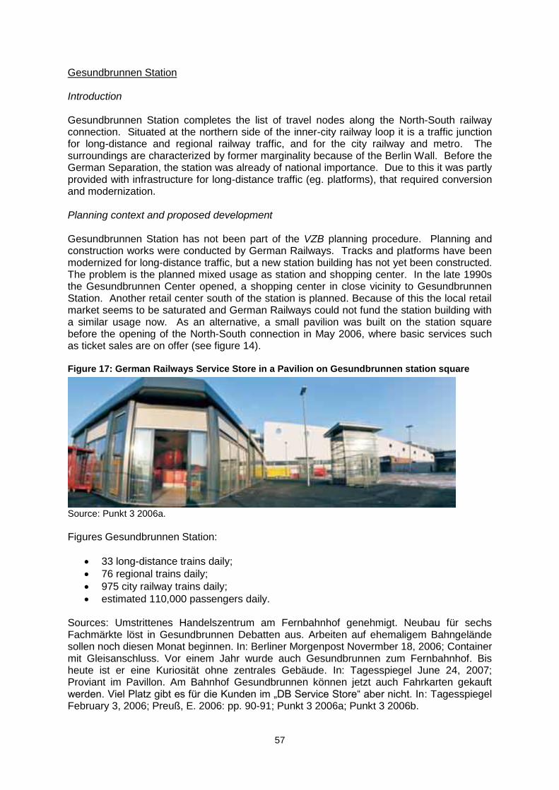
57
Gesundbrunnen Station Introduction Gesundbrunnen Station completes the list of travel nodes along the North-South railway connection. Situated at the northern side of the inner-city railway loop it is a traffic junction for long-distance and regional railway traffic, and for the city railway and metro. The surroundings are characterized by former marginality because of the Berlin Wall. Before the German Separation, the station was already of national importance. Due to this it was partly provided with infrastructure for long-distance traffic (eg. platforms), that required conversion and modernization. Planning context and proposed development Gesundbrunnen Station has not been part of the VZB planning procedure. Planning and construction works were conducted by German Railways. Tracks and platforms have been modernized for long-distance traffic, but a new station building has not yet been constructed. The problem is the planned mixed usage as station and shopping center. In the late 1990s the Gesundbrunnen Center opened, a shopping center in close vicinity to Gesundbrunnen Station. Another retail center south of the station is planned. Because of this the local retail market seems to be saturated and German Railways could not fund the station building with a similar usage now. As an alternative, a small pavilion was built on the station square before the opening of the North-South connection in May 2006, where basic services such as ticket sales are on offer (see figure 14). Figure 17: German Railways Service Store in a Pavilion on Gesundbrunnen station square
Source: Punkt 3 2006a.
Figures Gesundbrunnen Station:
33 long-distance trains daily;
76 regional trains daily;
975 city railway trains daily;
estimated 110,000 passengers daily. Sources: Umstrittenes Handelszentrum am Fernbahnhof genehmigt. Neubau für sechs Fachmärkte löst in Gesundbrunnen Debatten aus. Arbeiten auf ehemaligem Bahngelände sollen noch diesen Monat beginnen. In: Berliner Morgenpost Novermber 18, 2006; Container mit Gleisanschluss. Vor einem Jahr wurde auch Gesundbrunnen zum Fernbahnhof. Bis heute ist er eine Kuriosität ohne zentrales Gebäude. In: Tagesspiegel June 24, 2007; Proviant im Pavillon. Am Bahnhof Gesundbrunnen können jetzt auch Fahrkarten gekauft werden. Viel Platz gibt es für die Kunden im „DB Service Store“ aber nicht. In: Tagesspiegel February 3, 2006; Preuß, E. 2006: pp. 90-91; Punkt 3 2006a; Punkt 3 2006b.
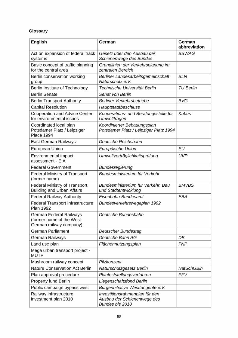
58
Glossary
English German German abbreviation
Act on expansion of federal track systems
Gesetz über den Ausbau der Schienenwege des Bundes
BSWAG
Basic concept of traffic planning for the central area
Grundlinien der Verkehrsplanung im zentralen Bereich
Berlin conservation working group
Berliner Landesarbeitsgemeinschaft Naturschutz e.V.
BLN
Berlin Institute of Technology Technische Universität Berlin TU Berlin
Berlin Senate Senat von Berlin
Berlin Transport Authority Berliner Verkehrsbetriebe BVG
Capital Resolution Hauptstadtbeschluss
Cooperation and Advice Center for environmental issues
Kooperations- und Beratungsstelle für Umweltfragen
Kubus
Coordinated local plan Potsdamer Platz / Leipziger Place 1994
Koordinierter Bebauungsplan Potsdamer Platz / Leipziger Platz 1994
East German Railways Deutsche Reichsbahn
European Union Europäische Union EU
Environmental impact assessment - EIA
Umweltverträglichkeitsprüfung UVP
Federal Government Bundesregierung
Federal Ministry of Transport (former name)
Bundesministerium für Verkehr
Federal Ministry of Transport, Building and Urban Affairs
Bundesministerium für Verkehr, Bau und Stadtentwicklung
BMVBS
Federal Railway Authority Eisenbahn-Bundesamt EBA
Federal Transport Infrastructure Plan 1992
Bundesverkehrswegeplan 1992
German Federal Railways (former name of the West German railway company)
Deutsche Bundesbahn
German Parliament Deutscher Bundestag
German Railways Deutsche Bahn AG DB
Land use plan Flächennutzungsplan FNP
Mega urban transport project - MUTP
Mushroom railway concept Pilzkonzept
Nature Conservation Act Berlin Naturschutzgesetz Berlin NatSchGBln
Plan approval procedure Planfeststellungsverfahren PFV
Property fund Berlin Liegenschaftsfond Berlin
Public campaign bypass west Bürgerinitiative Westtangente e.V.
Railway infrastructure investment plan 2010
Investitionsrahmenplan für den Ausbau der Schienenwege des Bundes bis 2010
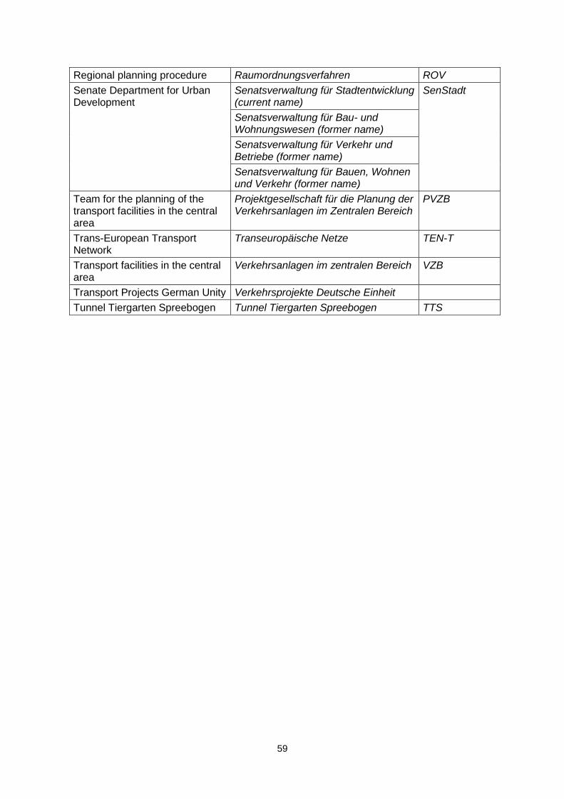
59
Regional planning procedure Raumordnungsverfahren ROV
Senate Department for Urban Development
Senatsverwaltung für Stadtentwicklung (current name)
SenStadt
Senatsverwaltung für Bau- und Wohnungswesen (former name)
Senatsverwaltung für Verkehr und Betriebe (former name)
Senatsverwaltung für Bauen, Wohnen und Verkehr (former name)
Team for the planning of the transport facilities in the central area
Projektgesellschaft für die Planung der Verkehrsanlagen im Zentralen Bereich
PVZB
Trans-European Transport Network
Transeuropäische Netze TEN-T
Transport facilities in the central area
Verkehrsanlagen im zentralen Bereich VZB
Transport Projects German Unity Verkehrsprojekte Deutsche Einheit
Tunnel Tiergarten Spreebogen Tunnel Tiergarten Spreebogen TTS