getis - introduction to geography 14th edition c2014...
TRANSCRIPT

1
C H A P T E R 1
C H A P T E R O U T L I N E 1.1 What Is Geography? 1.2 Evolution of the Discipline
Subfields of GeographyWhy Geography Matters
1.3 Some Core Geographic ConceptsLocation, Direction, and Distance
LocationDirectionDistance
This Italian valley village with its fields forms a cultural landscape in sharp contrast to the natural landscape of the background Dolomite Alps. © Creatas/Jupiter Images RF.
Size and ScalePhysical and Cultural AttributesAttributes of Place Are Always ChangingInterrelations between PlacesPlace Similarity and Regions
Spatial DistributionsTypes of Regions
1.4 Geography’s Themes and Standards 1.5 Organization of This Book
get22880_ch01_001-018.indd 1get22880_ch01_001-018.indd 1 9/13/13 4:26 PM9/13/13 4:26 PM
Final PDF to printer

2 Chapter 1
O n the days just before Halloween, 2012, citizens and authori-ties in the eastern United States were preparing for Hurri-
cane Sandy, whose eye was heading for Atlantic City, New Jersey, just 100 miles from New York City to the north, 60 miles from Philadelphia to the northwest, and 120 miles from Baltimore to the southwest. It had already been determined that the hurricane would be the largest in terms of area to ever strike the mainland of the United States. Although winds were strong, the great fear was that the surge of water into the harbors and along the beaches
would cause considerable damage to coastal buildings and roads. In addition, a particularly high tide was forecast for the same time that Hurricane Sandy would arrive. Even more disconcerting were meteorologists’ warnings that a storm arriving from the U.S. Mid-west would combine with the hurricane to create a superstorm. All of these fears were realized. Preparations, although extensive, could not cope with the devastating effects of the storm. On Octo-ber 29, Hurricane Sandy came ashore as predicted (see Figure 1.1). Having already left portions of several Caribbean islands in sham-bles, the storm caused 253 deaths overall along the hurricane’s seven-country path, and was responsible for $65 billion in dam-age, mainly in New York City and New Jersey, two of the most populous places in the United States. The only hurricane more costly was Katrina in 2005 which wiped out huge portions of the city of New Orleans. The storm surge fl ooded streets, subway tunnels, and the auto tunnels leading into and out of New York. Downed power lines forced New York, the world’s leading fi nan-cial center, to come to a standstill. Stock market trading was aban-doned concomitantly with the closing of a transportation system that normally carries about 3 million people a day. At the time that you are reading this, many areas on the East Coast are still attempting to recover from Hurricane Sandy.
In contrast to Hurricane Sandy, two years earlier a magnitude 7.0 earthquake devastated Haiti, a poverty-stricken country in the Caribbean. The Haiti earthquake caused the loss of an estimated 250,000 lives. News reports often refer to catastrophes such as these as “natural disasters,” but the devastating human consequences of the earthquake that struck Haiti, Hurricane Sandy, or innumer-able others were not due to nature alone. Past decisions about
where to build and where not to build, availability or lack of availability of economic resources, and government enforcement of building codes and land-use regula-tions played a major role in determining the outcomes of such disasters. The devasta-tion left by these disasters is a tragic reminder that human actions take place within the context of the environment. They are also a reminder that, just as maps and satel-lite images were essential tools in the storm prediction, emergency management, and recovery processes, many of the world’s pressing prob-lems require a geographic understanding that takes in earth systems, the locational aspects of human activities, and the relationships between human societies and their environment—all important themes in the discipline of geography.
Figure 1.1 Destruction from Hurricane Sandy in Great Kills Harbor, New York. The October 2013 hurricane caused more than $65 billion in damages and temporarily brought New York City, the world’s leading financial center, to a standstill. Natural disasters are tragic reminders of the close relationships between human societies and the natural environment. Courtesy U.S. Coast Guard photo by Petty Officer 2nd Class Stephen Lehmann.
L E A R N I N G O B J E C T I V E SAfter studying this chapter you should be able to:
1.1 Understand what geographers mean when they say that “location matters.”
1.2 Describe what is meant by physical and cultural landscapes.
1.3 Discuss how geography aids in understanding national and international problems.
1.4 Explain how the word spatial is used in the discipline of geography.
1.5 Appreciate which concepts are used to understand the processes of human interaction.
1.6 Summarize the kinds of understanding encompassed in the National Standards.
get22880_ch01_001-018.indd 2get22880_ch01_001-018.indd 2 9/4/13 3:27 PM9/4/13 3:27 PM
Final PDF to printer

Introduction 3
1.1 What Is Geography?Many people associate the word geography simply with knowing where things are: whether they be countries, such as Myanmar and Uruguay; cities, such as Timbuktu or Almaty; or deposits of natural resources, such as petroleum or iron ore. Some people pride themselves on knowing which rivers are the longest, which mountains are the tallest, and which deserts are the largest. Such factual knowledge about the world has value, permitting us to place current events in their proper spatial set-ting. When we hear of an earthquake in Turkey or an assault in Chechnya, we at least can visualize where they occurred. Know-ing why they occurred in those places, however, is considerably more important.
Geography is much more than place names and locations. It is the study of spatial variation, of how and why things differ from place to place on the surface of the earth. It is, further, the study of how observable spatial patterns evolved through time. Just as know-ing the names and locations of organs in the human body does not equip one to perform open-heart surgery, knowing where things are located is only the first step toward understanding why things are where they are, and what events and processes determine or change their distribution. Why are earthquakes common in Turkey but not in Russia, and why is Chechnya but not Tasmania wracked by insur-gency? Why are the mountains in the eastern United States rounded and those in the western states taller and more rugged? Why do you find a concentration of French speakers in Quebec but not in other parts of Canada?
In answering questions such as these, geographers focus on the interaction of people and social groups with their environment—planet Earth—and with one another; they seek to understand how and why physical and cultural spatial patterns evolved through time and continue to change. Because geographers study both the physical environment and human use of that environment, they are sensitive to the variety of forces affecting a place and the interac-tions among them. To explain why Brazilians burn a significant portion of the tropical rain forest each year, for example, they draw on their knowledge of the climate and soils of the Amazon Basin; population pressures, landlessness, and the need for greater agricultural area in rural Brazil; the country’s foreign debt status; midlatitude markets for lumber, beef, and soybeans; and Brazil’s economic development objectives. Understanding the environmen-tal consequences of the burning requires knowledge of, among other things, the oxygen and carbon balance of the earth; the con-tribution of the fires to the greenhouse effect, acid rain, and deple-tion of the ozone layer; and the relationships among deforestation, soil erosion, and floods.
Geography, therefore, is about earth space and the content of that space. We think of and respond to places from the standpoint of not only where they are but, what is more important, what they con-tain or what we think they contain. Reference to a place or an area usually calls up images about its physical nature or what people do there, and this often suggests to us, without our consciously think-ing about it, how those physical things and activities are related. Examples include “Bangladesh,” “farming,” and “flooding” as well as “Colorado,” “mountains,” and “skiing.” That is, the content of an area has both physical and cultural aspects, and geography is always concerned with understanding both (Figure 1.2).
1.2 Evolution of the DisciplineGeography’s combination of interests was apparent even in the work of the early Greek geographers who fi rst gave struc-ture to the discipline. Geography’s name was reputedly coined by the Greek scientist Eratosthenes over 2200 years ago from the words geo, “the earth,” and graphein, “to write.” From the beginning, that writing focused both on the physical struc-ture of the earth and on the nature and activities of the people who inhabited the various lands of the known world. To Strabo (c. 64 b.c.–a.d. 20), the task of geography was to “describe the several parts of the inhabited world, . . . to write the
Figure 1.2 Aspen, Colorado, demonstrates changing interactions between physical environment and human activity. Mineral resources, mountainous terrain, and abundant snowfall have made different specialized human uses attractive and possible. The brick buildings in the foreground are the legacy of its original settlement as a silver mining town, peaking with over 5000 residents in 1890 but declining to about 700 by 1930. The groomed ski slopes in the background represent the town’s current identity as a premier ski resort, year-round tourist destination and home to celebrities. © Punchstock RF.
get22880_ch01_001-018.indd 3get22880_ch01_001-018.indd 3 9/3/13 5:42 PM9/3/13 5:42 PM
Final PDF to printer

4 Chapter 1
assessment of the countries of the world [and] to treat the differ-ences between countries.” Even earlier, Herodotus (c. 484–425 b.c.) had found it necessary to devote much of his writing to the lands, peoples, economies, and customs of the various parts of the Per-sian Empire as necessary background to an understanding of the causes and course of the Persian wars.
Greek (and, later, Roman) geographers measured the earth, devised the global grid of parallels and meridians (marking latitudes and longitudes; see p. 7), and drew upon that grid surprisingly sophisticated maps of their known world ( Figure 1.3). They explored the apparent latitudinal variations in cli-mate and described in numerous works the familiar Mediter-ranean Basin and the more remote, partly rumored lands of northern Europe, Asia, and equatorial Africa. Employing nearly modern concepts, they described river systems, explored cycles of erosion and patterns of deposition, cited the dangers of deforestation, described variations in the natural landscape, and noted the consequences of environmental abuse. Against that physical backdrop, they focused their attention on what humans did in home and distant areas—how they lived; what their distinctive similarities and differences were in language, religion, and custom; and how they used, altered, and perhaps destroyed the lands they inhabited. Strabo, indeed, cautioned against the assumption that the nature and actions of humans
were determined by the physical environment they inhabited. He observed that humans were the active elements in a human-environmental partnership.
The interests guiding the early Greek and Roman geographers were and are enduring and universal. The ancient Chinese, for exam-ple, were as involved in geography as an explanatory viewpoint as were westerners, though there was no exchange between them. Fur-ther, as Christian Europe entered its Middle Ages between a.d. 800 and 1400 and lost its knowledge of Greek and Roman geographic work, Muslim scholars—who retained that knowledge—undertook to describe and analyze their known world in its physical, cultural, and regional variation.
In the 15th and 16th centuries, European voyages of explora-tion and discovery put geography at the forefront of the scientific revival. Modern geography had its origins in the surge of scholarly inquiry that, beginning in the 17th century, gave rise to many of the traditional academic disciplines we know today. In its Euro-pean rebirth, geography from the outset was recognized—as it always had been—as a broadly based integrative study. Patterns and processes of the physical landscape were early interests, as was concern with humans as part of the earth’s variation from place to place. The rapid development of geology, botany, zool-ogy, climatology, and other natural sciences by the end of the 18th century strengthened regional geographic investigation and
I n d i c u s
Lunae Mons
AethiopiasubAegypto
Arabia
ScythiaSerica
Sinarum
SitusExtra
Imaum
TaprobariaIns.
Equator
100 110 120 130140
150160
170
10
0
10
20
30
40
50
60
160140
120100806040
2060
50
40
30
20
10
0
10
1020
3040
5060 70 80 90
Montem
India Intra
Gangem Flu.
Felix
A e t h i o p i aI n t e r i o r
O c e an u s
Sinus
Gangeticus
Indus
Ganges
SinusHesperus
Magnus
Sinus
SinusPersicus
CaspiumMare
Scythia Intra Imaum Montem
Figure 1.3 World map of the 2d-century A.D. Greco-Egyptian geographer-astronomer Ptolemy. Ptolemy (Claudius Ptolemaeus) adopted a previously developed map grid of latitude and longitude based on the division of the circle into 360°, permitting a precise mathematical location for every recorded place. Unfortunately, errors of assumption and measurement rendered both the map and its accompanying six-volume gazetteer inaccurate. Ptolemy’s map, accepted in Europe as authoritative for nearly 1500 years, was published in many variants in the 15th and 16th centuries. The version shown here summarizes the extent and content of the original. Its underestimation of the earth’s size convinced Columbus a short westward voyage would carry him to Asia.
get22880_ch01_001-018.indd 4get22880_ch01_001-018.indd 4 9/3/13 5:43 PM9/3/13 5:43 PM
Final PDF to printer

Introduction 5
increased scholarly and popular awareness of the intricate inter-connections of things in space and between places. By that time, accurate determination of latitude and longitude and scientific mapping of the earth had made assignment of place information more reliable and comprehensive. A key figure during this period of geographic research was Alexander von Humboldt. Humboldt, for whom Humboldt University in Berlin, Germany, is named, led ambitious scientific expeditions to distant places and synthesized vast amounts of geographic data in his famous writings.
Subfields of GeographyDuring the 19th century, national censuses, trade statistics, and ethnographic studies gave fi rmer foundation to human geographic investigation. By the end of the 19th century, geography had become a distinctive and respected discipline in universities throughout Europe and in other regions of the world where European academic examples were followed. The proliferation of professional geog-raphers and geography programs resulted in the development of a whole series of increasingly specialized disciplinary subdivisions, many represented by separate chapters of this book. Political geog-raphy, urban geography, and economic geography are examples of some of these subdivisions.
Geography’s specialized subfields are not isolated from one another; rather, they are closely interrelated. Geography in all its subdivisions is characterized by three dominating interests. The first is in the spatial variation of physical and human phenom-ena on the surface of the earth; geography examines relationships between human societies and the natural environments that they occupy and modify. The second is a focus on the systems that link physical phenomena and human activities in one area of the earth with other areas. Together, these interests lead to a third endur-ing theme, that of regional analysis: geography studies human-environmental (or “ecological”) relationships and spatial systems in specific locational settings. This areal orientation pursued by some geographers is called regional geography.
Other geographers choose to identify particular classes of things, rather than segments of the earth’s surface, for specialized study. These systematic geographers may focus their attention on one or a few related aspects of the physical environment or of human populations and societies. In each case, the topic selected for study is examined in its interrelationships with other spatial systems and areal patterns. Physical geography directs its attention to the natural envi-ronmental side of the human-environmental structure. Its concerns are with landforms and their distribution, with atmospheric condi-tions and climatic patterns, with soils or vegetation associations, and the like. The other systematic branch of geography is human geog-raphy. Its emphasis is on people: where they are, what they are like, how they interact over space, and what kinds of landscapes of human use they erect on the natural landscapes they occupy.
Why Geography MattersThere are three good reasons people study geography. First, it is the only discipline concerned with understanding why and how both physical and cultural phenomena differ from place to place on the surface of the earth. Each chapter in this book is designed
to give you a basic knowledge of the many processes that shape our world. Chapter 3, for example, introduces you to the tectonic forces that warp, fold, and fault landforms; create volcanoes; and cause earthquakes and tsunami. The discussion of cultural geog-raphy in Chapter 6 will give you a framework for understanding the technological, sociological, and ideological components of culture and an awareness of the forces that bring about changes in a culture over time.
Second, a grasp of the broad concerns and topics of geogra-phy is vital to an understanding of the national and international problems that dominate daily news reports. Global climate change, the diffusion of AIDS and other diseases, international trade imbal-ances, inadequate food supply and population growth in develop-ing countries, turmoil in Africa and the Middle East—all of these problems have geographic dimensions, and geography helps explain them. To be geographically illiterate is to deny oneself not only the ability to comprehend local and world problems but also the oppor-tunity to contribute meaningfully to the development of policies for dealing with them.
Third, because geography is such a broad field of study, a great diversity of job opportunities await those who pursue college train-ing in the discipline. Geographic training opens the way to careers in a wide array of fields (see “Careers in Geography”). Geographi-cal techniques of analysis are used for interpreting remotely sensed images, determining the optimum location for new businesses, monitoring the spread of infectious diseases, delineating voting dis-tricts, and a host of other tasks. A good book to read is Why Geog-raphy Matters (Oxford University Press, 2005) by Harm J. de Blij.
1.3 Some Core Geographic ConceptsThe topics included within the broad fi eld of geography are diverse. That very diversity, however, emphasizes the reality that all geographers—whatever their particular topical or regional interests—are united by the similar questions they ask and the common set of basic concepts they employ to consider their answers. Of either a physical or cultural phenomenon, they will inquire: What is it? Where is it? How did it come to be what and where it is? Where is it in relation to other physical or cultural realities that affect it or are affected by it? How is it part of a func-tioning whole? How does its location affect people’s lives and the content of the area in which it is found?
These and similar questions are rooted in geography’s concern with earth space and are derived from enduring central themes in geography. In answering them, geographers draw upon a common store of concepts, terms, and methods of study that together form the basic structure and vocabulary of geography. Geographers believe that recognizing spatial patterns is the essential starting point for understanding how people live on and shape the earth’s surface.
Geographers use the word spatial as an essential modifier in framing their questions and forming their concepts. Geography, they say, is a spatial science. It is concerned with the spatial dis-tribution of phenomena, with the spatial extent of regions, the spa-tial behavior of people, the spatial relationships between places on the earth’s surface, and the spatial processes that underlie those behaviors and relationships. Geographers use spatial data to
get22880_ch01_001-018.indd 5get22880_ch01_001-018.indd 5 9/3/13 5:43 PM9/3/13 5:43 PM
Final PDF to printer

6 Chapter 1
Geography admirably serves the objectives of a liberal education. It can make us better-informed citizens, more able to understand the important issues facing our communities, our country, and our world and better prepared to contribute solutions.
Can it, as well, be a pathway to employment for those who wish to specialize in the discipline? The answer is yes, in a num-ber of different types of jobs. One broad cluster is concerned with supporting the fi eld itself through teaching and research. Teaching opportunities exist at all levels, from elementary to university post-graduate. Teachers with some training in geography are in increas-ing demand in elementary and high schools in the United States, refl ecting geography’s inclusion as a core subject in the federally adopted No Child Left Behind Act and the national determina-tion to create a geographically literate society (see “The National Standards,” p. 16). At the college level, specialized teaching and research in all branches of geography have long been established, and geographically trained scholars are prominently associated with urban, community, and environmental studies; regional sci-ence; locational economics; and other interdisciplinary programs.
Because of the breadth and diversity of the fi eld, training in geography involves the acquisition of techniques and approaches applicable to a wide variety of jobs outside the academic world. Modern geography is both a physical and social science and fos-ters a wealth of technical skills. The employment possibilities it presents are as many and varied as are the public and private agen-cies and enterprises dealing with the natural environment, with human economic and social activities, and with the acquisition and analysis of spatial data.
Many professional geographers work in government at the federal, state, and local levels and in a variety of international orga-nizations. Indeed, geographers have made careers in essentially all of the many bureaus and offi ces of the executive departments of
the U.S. national government—Agriculture, Commerce, Educa-tion, Health and Human Services, Homeland Security, Housing and Urban Development Interior, and others—and in their counter-parts at the state level. Such major independent federal agencies as the Central Intelligence Agency (CIA), National Aeronautics and Space Administration (NASA), Federal Trade Commission, National Geospatial-Intelligence Agency (NGA), Federal Aviation Agency, and many others have steady need for geographically trained workers.
Although many positions do not carry a geography title, physical geographers serve as water and other natural resource analysts, weather and climate experts, soil scientists, and the like. Areas of recent high demand include environmental managers and technicians and geographic information specialists. Geographers who have specialized in environmental studies fi nd jobs in both public and private agencies. Their work may include assessing the environmental impact of proposed development projects on such things as air and water quality and endangered species, as well as preparing the environmental impact statements required before construction can begin.
Human geographers work in many different roles in the pub-lic sector. Jobs include data acquisition and analysis in health care, transportation, population studies, economic development, and international economics. Many geography graduates fi nd positions as planners in local and state government agencies concerned with housing and community development, park and recreation plan-ning, and urban and regional planning. They map and analyze land use plans and transportation systems, monitor urban land development, make informed recommendations about the location of public facilities, and engage in basic social science research.
Most of the same specializations are found in the private sec-tor. Geographic training is ideal for such tasks as business plan-ning and market analysis; factory, store, and shopping center site
C A R E E R S I N G E O G R A P H Y
identify spatial patterns and to analyze spatial systems, spatial interaction, spatial diffusion, and spatial variation from place to place.
The word spatial comes, of course, from space, and to geog-raphers it always carries the idea of the way things are distributed, the way movements occur, and the way processes operate over the whole or a part of the surface of the earth. The geographer’s space, then, is earth space, the surface area occupied or available to be occupied by humans. Spatial phenomena have locations on that surface, and spatial interactions occur among places, things, and people within the earth area available to them. The need to under-stand those relationships, interactions, and processes helps frame the questions that geographers ask.
Those questions have their starting point in basic observations about the location and nature of places and about how places are similar to or different from one another. Such observations, though simply stated, are profoundly important to our comprehension of the world we occupy.
• Places have location, direction, and distance with respect to other places.
• A place has size; it is large, medium, or small. Scale is important.
• A place has both physical structure and cultural content. • The attributes, or characteristics, of places develop and
change over time. • The content of places is structured and explainable. • The elements of places interrelate with other places. • Places may be generalized into regions of similarities and
differences.
These basic notions are the means by which geographers express fundamental observations about the earth spaces they examine and put those observations into a common framework of refer-ence. Each of the concepts is worth further discussion, for they are not quite as simple as they seem.
Location, Direction, and DistanceLocation, direction, and distance are everyday ways of assess-ing the space around us and identifying our position in relation to other things and places of interest. They are also essential
get22880_ch01_001-018.indd 6get22880_ch01_001-018.indd 6 9/3/13 5:43 PM9/3/13 5:43 PM
Final PDF to printer

Introduction 7
Geographic Field of Concentration Employment Opportunities
Cartography and geographic information systems Cartographer for federal government (agencies such as Defense Mapping Agency, U.S. Geological Survey, or Environmental Protection Agency) or private sector (e.g., Environmental Systems Research Institute, ERDAS, Intergraph, or Bentley); map librarian; GIS specialist for planners, land developers, real estate agencies, utility companies, local government; remote-sensing analyst; surveyor
Physical geography Weather forecaster; outdoor guide; coastal zone manager; hydrologist; soil conservation/agricultural extension agent
Environmental studies Environmental manager; forestry technician; park ranger; hazardous waste planner
Cultural geography Community developer; Peace Corps volunteer; health care analyst
Economic geography Site selection analyst for business and industry; market researcher; traffi c/route delivery manager; real estate agent/broker/appraiser; economic development researcher
Urban and regional planning Urban and community planner; transportation planner; housing, park, and recreation planner; health services planner
Regional geography Area specialist for federal government; international business representative; travel agent; travel writer
Geographic education Elementary/secondary school teacher; general geography college professor; overseas teacher
a “Careers in Geography,” by Richard G. Boehm. Washington, D.C.: National Geographic Society, 1996. Previously published by Peterson’s Guides, Inc.
in understanding the processes of spatial interaction that fi g-ure so importantly in the study of both physical and human geography.
LocationThe location of places and things is the starting point of all geo-graphic study as well as of our personal movements and spatial actions in everyday life. We think of and refer to location in at least two different senses, absolute and relative.
Absolute location is the identification of place by a precise and accepted system of coordinates; therefore, sometimes it is called mathematical location. We have several such accepted systems of pinpointing positions. One of them is the global grid of parallels and meridians—that is, latitude and longitude (discussed in Chapter 2, pp. 21–23). With it, the absolute location of any point on the earth can be accurately described by reference to its degrees, minutes, and seconds of latitude and longitude.
Other coordinate systems are also in use. Survey systems such as the township, range, and section description of property in much
of the United States give mathematical locations on a regional level, and street address precisely defines a building according to the ref-erence system of an individual town. Absolute location is unique to each described place, is independent of any other characteristic or observation about that place, and has obvious value in the legal description of places, in measuring the distance separating places, or in finding directions between places on the earth’s surface.
When geographers—or real estate agents—remark that “loca-tion matters,” however, their reference is usually not to absolute but to relative location—the position of a place or thing in relation to that of other places or things (Figure 1.4). Relative location expresses spatial interconnection and interdependence and may carry social (neighbor-hood character) and economic (assessed valuations of vacant land) implications. On an immediate and personal level, we think of the location of the school library not in terms of its street address or room number but where it is relative to our classrooms, the cafeteria, or another reference point. On the larger scene, relative location tells us that people, things, and places exist not in a spatial vacuum but in a world of physical and cultural characteristics that differ from place to place.
selection; and community and economic development programs for banks, public utilities, and railroads. Publishers of maps, atlases, news and travel magazines, and the like employ geogra-phers as writers, editors, and mapmakers.
The combination of a traditional, broad-based liberal arts per-spective with the technical skills required in geographic research and analysis gives geography graduates a competitive edge in the labor market. These fi eld-based skills include familiarity with geographic information systems (GIS, explained in Chapter 2), cartography and computer mapping, remote sensing and photo-grammetry, and competence in data analysis and problem solving.
In particular, students with expertise in GIS, who are knowledge-able about data sources, hardware, and software, are fi nding they have ready access to employment opportunities. The following table, based on the booklet “Careers in Geography,”a summarizes some of the professional opportunities open to students who have specialized in one (or more) of the various subfi elds of geography. Also, be sure to read the discussion of geography careers accessed on the homepage of the Association of American Geographers at www.aag.org. Additional links on the topic of geography careers can be found in the Online Learning Center for this text. The link can be found in the Preface.
get22880_ch01_001-018.indd 7get22880_ch01_001-018.indd 7 9/3/13 5:43 PM9/3/13 5:43 PM
Final PDF to printer

Solana Beach
Encinitas
Poway
Ramona
LakesideSanteeLa Jolla
25
2015
30
30
2520
15
1010
10
15
15 55
PacificOcean
El CajonEl Cajon
Chula VistaChula Vista
National CityNational City
El CajonLa Mesa
LemonGrove
Chula Vista
Imperial Beach
Coronado
San DiegoSan DiegoSan Diego
National City
0 km
0 miles
5
5
805
5
15
8
78
52
94
56
163
Introduction 9
In both senses of the word, scale implies the degree of general-ization represented (Figure 1.7). Geographic inquiry may be broad or narrow; it occurs at many different size-scales. Climate may be an object of study, but research and generalization focused on climates of the world will differ in degree and kind from study of the microcli-mates of a city. Awareness of scale is very important. In geographic work, concepts, relationships, and understandings that have meaning at one scale may not be applicable at another.
For example, the study of world agricultural patterns may refer to global climate patterns, cultural food preferences, levels of economic development, and patterns of world trade. These large-scale relationships are of little concern in the study of crop patterns within single counties of the United States, where topography, soil and drainage conditions, farm size, ownership, and capitaliza-tion, or even personal management preferences, may be of greater explanatory significance.
Physical and Cultural AttributesAll places have individual physical and cultural attributes dis-tinguishing them from other places and giving them character, potential, and meaning. Geographers are concerned with identify-ing and analyzing the details of those attributes and, particularly,
Figure 1.6 Travel times from downtown San Diego, 2002, in minutes. Lines of equal travel time (isochrones: from Greek isos, equal, and chronos, time) mark off the different linear distances accessible within given spans of time from a starting point. The fingerlike outlines of isochrone boundaries reflect variations in road conditions, terrain, traffic congestion, and other aids or impediments to movement. Note the effect of freeways on travel time.
the Far East locate parts of Asia from the European perspective; they are retained in the Americas by custom and usage, even though one would normally travel westward across the Pacific, for example, to reach the “Far East” from California, British Columbia, or Chile. For many Americans, “back East” and “out West” are reflections of the migration paths of earlier genera-tions for whom home was in the eastern part of the country, to which they might look back. “Up North” and “down South” reflect our accepted custom of putting north at the top and south at the bottom of our maps.
DistanceDistance joins location and direction as a commonly understood term that has dual meanings for geographers. Like its two com-panion spatial concepts, distance may be viewed in both an abso-lute and a relative sense.
Absolute distance refers to the spatial separation between two points on the earth’s surface, measured by an accepted standard unit—such as miles or kilometers for widely separated locales, feet or meters for more closely spaced points. Relative distance trans-forms those linear measurements into other units more meaningful to human experience or decision making.
To know that two competing malls are about equidistant in miles from your residence is perhaps less important in planning your shopping trip than is knowing that, because of street conditions or traffic congestion, one is 5 minutes and the other 15 minutes away (Figure 1.6). Most people, in fact, think of time distance rather than linear distance in their daily activities; downtown is 20 minutes by bus, the library is a 5-minute walk. In some instances, money rather than time is the distance transformation. An urban destina-tion might be estimated to be a $10 cab ride away, information that may affect either the decision to make the trip at all or the choice of travel mode to get there. As a college student, you already know that rooms and apartments are less expensive at a greater distance from campus.
A psychological transformation of linear distance is also fre-quent. A solitary late-night walk back to the car through an unfa-miliar or dangerous neighborhood seems far longer than a daytime stroll of the same distance through familiar and friendly territory. A first-time trip to a new destination frequently seems much longer than the return trip over the same path. Nonlinear distance and spa-tial interaction are further considered in Chapter 7.
Size and ScaleWhen we say that a place may be large, middle size, or small, we speak both of the nature of the place itself and of the generaliza-tions that can be made about it. Geographers are concerned with scale, though we may use that term in different ways. We can, for example, study a problem such as population or landforms at the local scale or on a global scale. Here, the reference is purely to the size of unit studied. More technically, scale tells us the relation-ship between the size of an area on a map and the actual size of the mapped area on the surface of the earth. In this sense, as Chapter 2 makes clear, scale is a feature of every map and is essential to recognizing what is shown on that map.
get22880_ch01_001-018.indd 9get22880_ch01_001-018.indd 9 9/3/13 5:43 PM9/3/13 5:43 PM
Final PDF to printer

90
Lake PontchartrainL. PontchartrainL. PontchartrainCausewayCauseway
L. PontchartrainCauseway
University ofUniversity ofNew OrleansNew Orleans
DowntownDowntown
Gentilly Gentilly RidgeRidge
University ofNew Orleans
French Quarter
Downtown
0Miles
3
Mississippi River
10
610
1010
10
New OrleansNew OrleansNew Orleans
Gentilly Ridge
Areas below sea level(a) Mississippi River Basin
New Orleans
(b)
NorthPole
Washington D.C.
Ottawa
Moscow
Alaska(U.S.A.)
PacificOcean
AtlanticOcean
180°
90°
30°
60°
150°
120°
150°
120° 60°
30°
0°
30°
60°
90°
R U S S I A
UNITED STATES
C A N A D A
Equato
r
8 Chapter 1
New York City, for example, may be described in absolute terms as located at (approximately) latitude 40°43′N (read as 40 degrees, 43 minutes north) and longitude 73°58′W. We have a better understanding of the meaning of its location, however, when
reference is made to its spatial relationships: to the continental interior through the Hudson-Mohawk lowland corridor or to its position on the eastern seaboard of the United States. Within the city, we gain understanding of the locational significance of Cen-tral Park or the Lower East Side not solely by reference to the street addresses or city blocks they occupy but also by their spatial and functional relationships to the total land use, activity, and popula-tion patterns of New York City.
In view of these different ways of looking at location, geog-raphers make a distinction between the site and the situation of a place (Figure 1.5). Site, an absolute location concept, refers to the physical and cultural characteristics and attributes of the place itself. It is more than mathematical location, for it tells us something about the specific features of that place. Situation, on the other hand, refers to the relations between a place and other places. It is an expression of relative location with particu-lar reference to items of significance to the place in question. Site and situation in the city context are further examined in Chapter 11.
DirectionDirection is the second universal spatial concept. Like location, it has more than one meaning and can be expressed in absolute or relative terms. Absolute direction is based on the cardinal points of north, south, east, and west. These appear in all cultures, derived from the obvious “givens” of nature: the rising and setting of the sun for east and west, the sky location of the noontime sun and of certain fi xed stars for north and south.
We also commonly use relative, or relational, directions. In the United States, we go “out West,” “back East,” or “down South”; we worry about conflict in the “Near East” or economic competition from the “Far Eastern countries.” Despite their ref-erence to cardinal compass points, these directional references are culturally based and locationally variable. The Near East and
Figure 1.5 Site and Situation (a) The site of New Orleans is hardly ideal for building a city. The French occupied the most suitable high ground they could find near the mouth of the Mississippi River. The site extends from the “high ground” on the natural levee next to the Mississippi River to former wetlands near Lake Pontchartrain. Much of the city and its suburbs are below sea level on sinking soils composed of soft sediments deposited by past river floods. (b) The situation of New Orleans is ideal for building a city. New Orleans is connected to 9000 miles of navigable waterways through the Mississippi River which drains a basin that stretches from the Rocky Mountains to the Appalachian Mountains.
Figure 1.4 The reality of relative location on the globe may be strikingly different from the impressions we form from flat maps. The position of Russia with respect to North America when observed from a polar perspective emphasizes that relative location properly viewed is important to our understanding of spatial relationships and interactions between the two world areas.
get22880_ch01_001-018.indd 8get22880_ch01_001-018.indd 8 9/3/13 5:43 PM9/3/13 5:43 PM
Final PDF to printer

10 Chapter 1
with recognizing the interrelationship between the physical and cultural components of area: the human-environmental interface.
The physical characteristics of a place are such natural aspects as its climate, soil, water supplies, mineral resources, terrain fea-tures, and the like. These natural landscape attributes provide the setting within which human action occurs. They help shape—but do not dictate—how people live. The resource base, for example, is physically determined, though how resources are perceived and utilized is culturally conditioned.
Environmental circumstances directly affect agricultural potential and reliability; indirectly, they may affect such matters as employment patterns, trade flows, population distributions, national diets, and so on. The physical environment simultaneously presents advantages and disadvantages with which humans must deal. Thus, most places offer trade-offs in terms of climate favorability, natural hazards, farming and fishing productivity, natural resources, and natural scenery. For example, a scenic volcano may someday erupt, or a mild, coastal location may be vulnerable to hurricanes, and so forth. Physical environmental patterns and processes are explored in Chapters 3 and 4 of this book.
At the same time, by occupying a given place, people modify its physical attributes. The visible imprint of that human activity is called the cultural landscape. It, too, exists at different scales and at different levels of visibility. Contrasts in agricultural practices and land use between Mexico and southern California are evident in Figure 1.8, whereas the signs, structures, and people of Los Ange-les’s Chinatown leave a smaller, more confined imprint within the larger cultural landscape of the metropolitan area itself.
The physical and human characteristics of places are the keys to understanding both the simple and the complex interactions and interconnections between people and the environments they occupy and modify. Those interconnections and modifications are not static or permanent but are subject to continual change.
The existence of the U.S. Environmental Protection Agency (and its counterparts elsewhere) is a reminder that humans are the active and frequently harmful agents in the continuing interplay between the cultural and physical worlds (Figure 1.9). Virtually every human activity leaves its imprint on the earth’s soil, water, vegetation, animal life, and other resources, as well as on the atmo-sphere common to all earth space, as Chapters 12 and 13 make clear.
Attributes of Place Are Always ChangingThe physical environment surrounding us seems eternal and unchanging but, of course, it is not. In the framework of geologic time, change is both continuous and pronounced. Islands form and disappear; mountains rise and are worn low to swampy plains; vast continental glaciers form, move, and melt away, and sea levels fall and rise in response. Geologic time is long, but the forces that give shape to the land are timeless and relentless.
Even within the short period of time since the most recent retreat of continental glaciers—12,000 or 13,000 years ago—the environments occupied by humans have been subject to change. Glacial retreat itself marked a period of climatic alteration, extend-ing the area habitable by humans to include vast reaches of north-ern Eurasia and North America formerly covered by thousands of
POPULATION DENSITIESDensity per SquareMile
19 or less 7 or less20–3940–79
80–159
8–1516–3031–61
320–639640–1279
160–319
1280 or more
124–24662–123
247–493494 or more
Kilometer
Midwestern States
(a)
(b)
Illinois Counties
North Dakota
Minnesota
WisconsinSouth Dakota
Iowa
Illinois
Nebraska
Kansas Missouri
IndianaOhio
Michigan
Figure 1.7 Population density and map scale. “Truth” depends on one’s scale of inquiry. Map (a) reveals that the maximum year 2010 population density of midwestern states was no more than 123 people per square kilometer (319 per sq mi). From map (b), however, we see that population densities in three Illinois counties exceeded 494 people per square kilometer (1280 per sq mi) in 2010. If we were to reduce our scale of inquiry even further, examining individual city blocks in Chicago, we would find densities reaching 2500 or more people per square kilometer (10,000 per sq mi). Scale matters!
get22880_ch01_001-018.indd 10get22880_ch01_001-018.indd 10 9/3/13 5:43 PM9/3/13 5:43 PM
Final PDF to printer

Introduction 11
feet of ice. With moderating climatic conditions came changes in vegetation and fauna. On the global scale, these were natural envi-ronmental changes; humans were as yet too few in number and
Figure 1.8 This Landsat satellite image reveals contrasting cultural landscapes along the Mexico-California border. Move your eyes from the Salton Sea (the dark patch at the top of the image) southward to the agricultural land extending to the edge of the picture. Notice how the regularity of the fields and the bright colors (representing growing vegetation) give way to a marked break, where irregularly shaped fields and less prosperous agriculture are evident. Above the break is the Imperial Valley of California; below the border is Mexico. © NASA.
too limited in technology to alter materially the course of physical events. On the regional scale, however, even early human societies exerted an impact on the environments they occupied. Fire was used to clear forest undergrowth, to maintain or extend grassland for grazing animals and to drive them in the hunt, and later to clear openings for rudimentary agriculture.
With the dawn of civilizations and the invention and spread of agricultural technologies, humans accelerated their management and alteration of the now no longer “natural” environment. Even the classical Greeks noted how the landscape they occupied differed—for the worse—from its former condition. With growing numbers of people, and particularly with industrialization and the spread of European exploitative technologies throughout the world, the pace of change in the content of area accelerated. The built landscape—the product of human effort—increasingly replaced the natural landscape. Each new settlement or city; each agricultural assault on forests; and each new mine, dam, or factory changed the content of regions and altered the temporarily established spatial interconnec-tions between humans and the environment.
Characteristics of places today are the result of constantly changing past conditions. They are the forerunners of differing human-environmental balances yet to be struck. Geographers are concerned with places at given moments of time. But to understand fully the nature and development of places, to appreciate the signifi-cance of their relative locations, and to understand the interplay of their physical and cultural characteristics, geographers must view places as the present result of past operation of physical and cultural processes (Figure 1.10).
You will recall that one of the questions geographers ask about a place or thing is “How did it come to be what and where it is?” This is an inquiry about process and about becoming. The forces and events shaping the physical and explaining the cultural environ-ment of places today are an important focus of geography and are the topics of most of the chapters of this book. To understand them is to appreciate the changing nature of the spatial order of our con-temporary world.
Figure 1.9 Sites such as this Anacortes, Washington, oil refinery are major emitters of potentially toxic chemicals to the atmosphere, land, and water. Pollution control technologies have significantly reduced, but not eliminated, their negative impacts on the environment. However unsightly or smelly they may be, oil refineries provide the gasoline, diesel, heating oil, jet fuel, and asphalt products that are necessary to economic activity and everyday life in industrialized countries. © Walter Siegmund.
get22880_ch01_001-018.indd 11get22880_ch01_001-018.indd 11 9/3/13 5:43 PM9/3/13 5:43 PM
Final PDF to printer

12 Chapter 1
Interrelations between PlacesThe concepts of relative location and distance that were intro-duced earlier lead directly to another fundamental spatial reality: places are interrelated with other places in structured and com-prehensible ways. In describing the processes and patterns of that human interaction, geographers add accessibility and connectiv-ity to the ideas of location and distance.
Tobler’s First Law of Geography tells us that, in a spatial sense, everything is related to everything else but relationships are stron-ger when things are near one another. Our observation, there-fore, is that interaction between places diminishes in intensity and frequency as distance between them increases—a statement of the idea of “distance decay,” which we explore in Chapter 7.
Are you more likely to go to a fast-food outlet next door or to a nearly identical restaurant across town? Our decision making sometimes is unpredictable, but in this case you can see that most people would probably choose the nearer place more often.
Consideration of distance implies assessment of accessibility.How easy or difficult is it to overcome the “friction of distance”? That is, how easy or difficult is it to overcome the barrier of the time and space separation of places? Distance isolated North America from Europe until the development of ships (and aircraft) that reduced the effective distance between the continents. All parts of ancient and medieval cities were accessible by walking; they were “pedestrian cities,” a status lost as cities expanded in area and population with industrialization. Accessibility between city districts could be maintained only by the development of pub-lic transit systems whose fixed lines of travel increased the ease of movement between connected points and reduced it between areas not on the transit lines themselves.
Accessibility, therefore, suggests the idea of connectivity,a broader concept implying all the tangible and intangible ways in which places are connected: by physical telephone lines, street and road systems, and pipelines and sewers; by unrestrained walk-ing across open countryside; by radio and TV broadcasts; by cell phone service areas; and in nature even by movements of wind systems and ocean currents. Where routes are fixed and flow is channelized, networks—the patterns of routes connecting sets of places—determine the efficiency of movement and the connected-ness of points. Demand for universal instantaneous connectivity is common and unquestioned in today’s advanced societies. Tech-nologies and devices to achieve it proliferate, as our own lifestyles show. Cell phones, e-mail, broadband wireless Internet, instant messaging, and more have erased time and distance barriers for-merly separating and isolating individuals and groups and have reduced our dependence on physical movement and on networks fixed in the landscape.
There is, inevitably, interchange between connected places. Spatial diffusion is the process of dispersion of an idea or a thing (a new consumer product or a new song, for example) from a center of origin to more distant points. The rate and extent of that diffusion are affected, again, by the distance separating the origin of the new idea or technology and other places where it is eventually adopted. Diffusion rates are also affected by such factors as population den-sities, means of communication, advantages of the innovation, and importance or prestige of the originating node. Further discussion of spatial diffusion is found in Chapter 7.
Geographers study the dynamics of spatial relationships. Movement, connection, and interaction are part of the social and economic processes that give character to places and regions ( Figure 1.11). The increasingly global reach of those spatial interac-tions is expressed in the term globalization. Globalization implies the increasing interconnection of more and more peoples and parts of the world as the full range of social, cultural, political, economic, and environmental processes becomes international in scale and effect. Promoted by continuing advances in worldwide accessibility and connectivity, globalization encompasses other core geographic concepts of spatial interaction, accessibility, connectivity, and dif-fusion. More detailed implications of globalization will be touched on in Chapters 7 and 10 .
Figure 1.10 The process of change in a cultural landscape. (a) Dubai, a city-state in the United Arab Emirates, was a modest-sized fishing town in the 1960s. (b) Discovery of oil and growth as a tax-free haven and cosmopolitan business center led to fantastic growth. Former places are hardly recognizable today. The city is home to the world's tallest building and the world's largest shopping mall which features an indoor ski resort. (a) © Chris Ware/Keystone Features/Hulton Archive/Getty (b) © Chris Schmid/Getty.
(a)
(b)
get22880_ch01_001-018.indd 12get22880_ch01_001-018.indd 12 9/3/13 5:43 PM9/3/13 5:43 PM
Final PDF to printer

SILICON VALLEYTotal Number of Trips by
Place of Residence10–5051–100101–200201–500501–10001001–2000
SONOMA
MARIN
N
SOLANO
CONTRA COSTA
SAN FRANCISCO
SANTA CLARA
ALAMEDA
SAN MATEO
5 miles
5 km
Introduction 13
Place Similarity and RegionsThe distinctive characteristics of places—physical, cultural, locational—immediately suggest two geographically impor-tant ideas. The fi rst is that no two places on the surface of the earth can be exactly the same. Not only do they have different absolute locations, but—as in the features of the human face—the precise mix of physical and cultural characteristics of place is never exactly duplicated. The inevitable uniqueness of place would seem to impose impossible problems of generalizing spa-tial information.
That this is not the case results from the second important idea, that the natural and cultural characteristics of places show patterns of similarity in some areas. For example, a geographer doing fieldwork in France may find that all farmers in one area
use a similar, specialized technique to build fences around their fields. Often, such similarities are striking enough for us to con-clude that spatial regularities exist. They permit us to recognize and define regions, earth areas that display significant elements of internal uniformity and external differences from surround-ing territories. Places are, therefore, both unlike and like other places, creating patterns of areal differences and coherent spatial similarity.
The problems of the historian and the geographer are similar. Each must generalize about items of study that are essentially unique. The historian creates arbitrary but meaningful and useful historical periods for reference and study. The “Roaring Twenties” and the “Victorian Era” are shorthand summary names for spe-cific time spans, internally quite complex and varied but signifi-cantly distinct from what went before or followed after. The region is the geographer’s equivalent of the historian’s era: a device to classify the complex reality of the earth’s surface into manage-able pieces. Just as historians focus on key events to characterize certain historical periods, geographers focus on key unifying ele-ments or similarities to determine the boundaries of regions. By identifying and naming regions, a complex set of interrelated envi-ronmental or cultural attributes can easily be conveyed through a simpler construct.
Spatial DistributionsRegions are not “given” in nature any more than “eras” are given in the course of human events. Regions are devised; they are spa-tial summaries designed to bring order to the infi nite diversity of the earth’s surface. At their root, they are based on the recognition and mapping of spatial distributions—the spatial arrangement of environmental, human, or organizational features selected for study. For example, the location of Welsh speakers in Great Britain is a distribution that can be identifi ed and mapped. As many spatial dis-tributions exist as there are imaginable physical, cultural, or connec-tivity elements of area to examine. Those that are selected for study, however, are those that contribute to the understanding of a specifi c topic or problem.
Let us assume that we are interested in studying burglary rates in the United States. Statistics indicate that some states have sig-nificantly higher rates than others. A resident of Arizona is roughly three times as likely to be a victim of a burglary as a resident of North Dakota. We would ask whether the distribution of rates appears random. Mapping the spatial distribution is a first step and shows that the states with the highest rates appear to be clustered along the southern border and the West Coast. Next, we must try to explain the spatial distribution. We would ask what factors account for the observed pattern. We would ask whether the pattern is simi-lar to that for other types of crimes. Since it is commonly assumed that big cities, poverty, and youthful populations are associated with crime, we would want to see whether any of those distributions were correlated with burglary rates.
When two spatial distributions are closely related, they are said to have a spatial association. In Figure 1.12, we observe that com-munities in Texas where consuming alcoholic beverages is legal tend to have a majority of Catholic or Lutheran residents, while so-called dry communities are more likely to be predominantly Baptist
Figure 1.11 An indication of one form of spatial interaction and connectivity is suggested by this “desire line” map recording the volume of daily work trips within the San Francisco Bay area to the Silicon Valley employment node. The ends of the desire lines define the outer reaches of a physical interaction region defined by the network of connecting roads and routes. The region changed in size and shape over time as the network was enlarged and improved, the Silicon Valley employment base expanded, and the commuting range of workers increased. The map, of course, gives no indication of the global reach of the Silicon Valley’s accessibility and interaction through other means of communication and interchange. Redrawn with permission from Robert Cervero, Suburban Gridlock. © 1986 Center for Urban Policy Research, Rutgers, the State University of New Jersey.
get22880_ch01_001-018.indd 13get22880_ch01_001-018.indd 13 9/3/13 5:43 PM9/3/13 5:43 PM
Final PDF to printer

Data for 1971 Status in 1972
0 150 km
100 m0
Wholly “dry” areas Areas where some or all alcoholic beverages may be purchased
Dominantly Baptistand Methodist areas
Dominantly Catholicand Lutheran areas
14 Chapter 1
Figure 1.12 Spatial distributions of religion and alcohol sales in Texas. Catholic and Lutheran areas tend to be "wet," and Baptist and Methodist areas tend to retain prohibition. Both Baptist and Methodist churches have traditionally taken a stand against the consumption of alcohol. The two maps suggest a spatial association between religion and alcohol prohibition laws. Sources: 38th Annual Report of the Texas Alcoholic Beverage Commission, Austin, 1972, p. 49; and Churches and Church Membership in the United States: 1971, National Council of Churches of Christ in the U.S.A., 1974.
or Methodist. Geographers attempt to identify spatial associations that are stronger than expected by chance alone.
Types of RegionsRegions may be administrative, formal, functional, or perceptual. Administrative regions are created by laws, treaties, or regulations. Examples include countries, states, counties, cities, and school dis-tricts. The political map of the world shows the boundaries of one set of administrative regions. Even the end zone on a football fi eld is an administrative region. Boundaries of administrative regions are as precisely defi ned as measurement allows, and generally laws and rules are applied uniformly to all places within those boundaries.
A formal (or uniform) region is an area of essential uniformity for a single physical or cultural feature or a limited combination of physical or cultural features. The name Corn Belt suggests a region based on its farm economy and predominant crop. Figure 1.13 depicts formal regional patterns. The formal region is based on objective, often statistically derived identifiers. Whatever the basis of its definition, the formal region is a sizable area over which a valid generalization of uniformity may be made with respect to some attribute or attributes—that is, the attribute holds true for the entire region.
A functional (or nodal) region, in contrast, may be visualized as a spatial system. Its parts are interdependent, and throughout its extent the functional region operates as a dynamic, organizational unit. Like the formal region, a functional region is objectively
defined; but a functional region has unity in the manner of its oper-ational connectivity, not in the sense of static content. The defin-ing characteristics of interaction and connection of a functional region are most clearly recognized at its node or core and lessen in dominance toward its margins. As the degree and extent of control and interaction in an area change, the boundaries of the functional region change in response; that is, a nodal region’s boundaries remain constant only as long as the interchanges that establish it remain unaltered. Examples are the trade areas of towns, the cir-culation area of a newspaper, the area that receives a television station’s signal, and the territories subordinate to the financial, administrative, health care, retail, and service functions of regional capitals, such as Chicago, Atlanta, or Minneapolis (Figure 1.14).
Perceptual (or vernacular or popular) regions are less rigor-ously structured than the formal and functional regions geographers devise. They are regions that exist and have reality in the percep-tions of their inhabitants and the general society. As composites of the mental maps of ordinary folk, they reflect feelings and images rather than objective data. Because of that, perceptual regions may be more meaningful in individuals’ daily lives than the more objec-tive regions of geographers.
Ordinary people have a clear idea of spatial variation and employ the regional concept to distinguish between territorial enti-ties. People individually and collectively agree on where they live. The vernacular regions they recognize have reality in their minds and are reflected in regionally based names employed in busi-nesses, by sports teams, or in advertising slogans. The frequency
get22880_ch01_001-018.indd 14get22880_ch01_001-018.indd 14 9/3/13 5:43 PM9/3/13 5:43 PM
Final PDF to printer

Sugarcane
Perth
AdelaideSydney
Darwin500 miles
500 km
Brisbane
MelbourneIntensive livestock farming and dairyingForest, grazingExtensive sheep grazing
Extensive cattle grazingCrop and livestock farmingNo significant use
Houston
Dallas
Atlanta
Tampa
Balt.Pitt.
Cin.
Cleve.Det.
Buff.
Chi.
Ind.
Milwaukee
St.Louis
Kansas CityDenver
San Diego
Los Angeles
San Francisco
Portland
Seattle
Washington D.C.
PhiladelphiaNew York
Boston
Miami
0 miles 200
0 km 400
400
NewOrleans
Minneapolis
Introduction 15
Figure 1.13 This generalized land use map of Australia is composed of formal regions whose internal economic characteristics show essential uniformities, setting them off from adjacent territories of different condition or use.
Figure 1.14 The functional regions shown on this map were based on linkages between large banks of major central cities and the “correspondent” banks they formerly served in smaller towns. Although the rise of nationwide banks has reduced their role, the regions once defined an important form of connectivity between principal cities and locales beyond their own immediate metropolitan area. Source: Data from Annals of the Association of American Geographers, John R. Borchert, Vol. 62, p. 358, Association of American Geographers, 1972.
get22880_ch01_001-018.indd 15get22880_ch01_001-018.indd 15 9/12/13 12:13 AM9/12/13 12:13 AM
Final PDF to printer
Gulf
South
South
Midwest
North
West
Pacific
NorthwestPacific
EastMiddle AtlanticNo Regional
Affiliation
Southwest
NortheastNew England
Atlantic
East
Acadia
16 Chapter 1
Figure 1.15 Perceptual (vernacular or popular) regions of North America. Source: Wilbur Zelinsky, “North America's Vernacular Regions” in Annals of the Association of American Geographers Vol. 70, Figure l, p. 14, 1980. Redrawn with permission.
The inclusion of geography as a subject area to be assessed refl ects the conviction that a grasp of the skills and understandings of geography is essential in an American educational system “tai-lored to the needs of productive and responsible citizenship in the global economy.” Along with the “basic observations” reviewed in the text, the National Geography Standards 1994 help frame the kinds of understanding we will seek in the following pages and suggest the purpose and benefi t of further study of geography.
The 18 geography standards tell us the following: The geo-graphically informed person knows and understands:
Geographic Techniques and Skills 1. How to use maps and other geographic tools and technolo-
gies to acquire, process, and report information from a spa-tial perspective.
2. How to use mental maps to organize information about people, places, and environments in a spatial context.
3. How to analyze the spatial organization of people, places, and environments on Earth’s surface.
Physical Systems 4. The physical processes that shape the patterns of Earth’s
surface. 5. The characteristics and spatial distribution of ecosystems
on Earth’s surface.
Human Systems 6. The characteristics, distribution, and migration of human
populations on Earth’s surface.
7. The characteristics, distribution, and complexity of Earth’s cultural mosaics.
8. The patterns and networks of economic interdependence on Earth’s surface.
9. The processes, patterns, and functions of human settlement. 10. How the forces of cooperation and confl ict among people
infl uence the division and control of Earth’s surface.
Environment and Society 11. How human actions modify the physical environment. 12. How physical systems affect human systems. 13. The changes that occur in the meaning, use, distribution,
and importance of resources.
The Uses of Geography 14. How to apply geography to interpret the past. 15. How to apply geography to interpret the present and plan
for the future.
Places and Regions 16. The physical and human characteristics of places. 17. That people create regions to interpret Earth’s complexity. 18. How culture and experience infl uence people’s perceptions
of places and regions.
Source: Geography for Life: National Geography Standards 1994. Washington, D.C.: National Geographic Research and Exploration, 1994.
T H E N A T I O N A L S T A N D A R D S
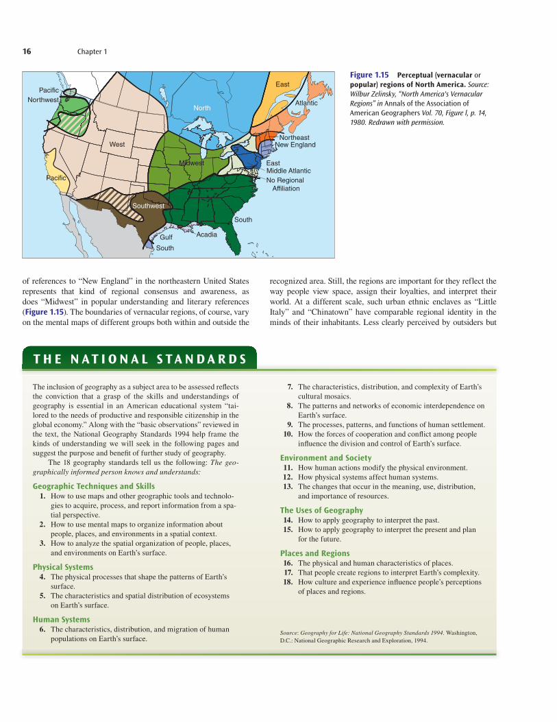
of references to “New England” in the northeastern United States represents that kind of regional consensus and awareness, as does “Midwest” in popular understanding and literary references ( Figure 1.15). The boundaries of vernacular regions, of course, vary on the mental maps of different groups both within and outside the
recognized area. Still, the regions are important for they reflect the way people view space, assign their loyalties, and interpret their world. At a different scale, such urban ethnic enclaves as “Little Italy” and “Chinatown” have comparable regional identity in the minds of their inhabitants. Less clearly perceived by outsiders but
get22880_ch01_001-018.indd 16get22880_ch01_001-018.indd 16 9/3/13 5:43 PM9/3/13 5:43 PM
Final PDF to printer

Introduction 17
unmistakable to their inhabitants are the “turfs” of urban clubs or gangs. Their boundaries are sharp, and the perceived distinctions between them are paramount in the daily lives and activities of their occupants.
As you read the chapters of this book, notice how many exam-ples of regions and regionalism are presented in map form and dis-cussed in the text. Note, too, how those depictions and discussions vary between the three different regional types as the subjects and purposes of the examples change.
1.4 Geography’s Themes and StandardsThe core geographic concepts discussed so far in this chap-ter refl ect both the “fundamental themes in geography” and the “National Geography Standards.” Together, the “themes” and “standards” have helped organize and structure the study of geog-raphy over the past several years at all grade and college levels. Both focus on the development of geographic literacy. The for-mer represent an instructional approach keyed to identifi cation and instruction in the knowledge, skills, and perspectives students should gain from a structured program in geographic educa-tion. The latter—“standards”—codify the essential subject mat-ter, skills, and perspectives of geography essential to the mental equipment of all educated adults.
The five fundamental themes, as summarized by a joint com-mittee of the National Council for Geographic Education and the Association of American Geographers, are those basic concepts and topics that recur in all geographic inquiry and at all levels of instruction:
• location: the meaning of relative and absolute position on the earth’s surface;
• place: the distinctive and distinguishing physical and human characteristics of locales;
• relationships within places: the development and conse-quences of human-environmental interactions;
• movement: patterns and change in human spatial interaction on the earth;
• regions: how they form and change.
The National Geography Standards were established as part of the nationally adopted Goals 2000: Educate America Act (see “The National Standards”). Designed specifically as guidelines to the essential geographic literacy to be acquired by students who have gone through the U.S. public school system, the standards address the same conviction underlying this edition of Introduction to Geography—that being literate in geography is a necessary part of the mental framework of all informed persons.
1.5 Organization of This BookDespite its outward appearance of diversity, geography has a broad consistency of purpose achieved by having a lim-ited number of distinct but closely related areas of study. The unifying categories within which geographers work and the plan of this book can be seen in Figure 1.16. Not included in this book, however, is an emphasis on specific regions, such
as Europe, the Mississippi Valley, the developing world, etc. These are discussed in individual courses where students can gain a deep understanding and knowledge of a particular area.
In this book, we begin with a discussion of fundamental con-cepts and techniques of geographic analysis (Chapters 1 and 2). The emphasis is on the nature of maps and the skills necessary to create them. Basic cartography (mapmaking) is discussed as well as some of the exciting new technologies, such as geographic information systems (GIS) and global positioning systems (GPS), which allow for great detail, flexibility in map use, and creativ-ity in “seeing” the earth as it has never been seen before. In our introduction to spatial analysis, we consider ways in which maps can be used to understand patterns of change, such as population growth, the spread of a disease, or the diffusion of a commercial enterprise, and so on.
To understand the physical and human characteristics of the earth, we begin, in Chapter 3, Physical Geography: Landforms, to explore physical systems. The approach of geography is to attempt to recognize the processes responsible for surface physical features such as mountains and streams. In Chapter 4, weather and climate
Location Ch. 9: Primary ActivitiesCh. 10: Manufacturing and Service ActivitiesCh. 11: Urban
Physical SystemsCh. 3: LandformsCh. 4: Weather and Climate
Human SystemsCh. 5: Population Ch. 6: Cultural Ch. 7: Human InteractionCh. 8: Political
EnvironmentCh. 12: Natural ResourcesCh. 13: Human Impact
Techniques ofGeographic AnalysisCh. 2: GeographicTechniques and Skills
The Uses of GeographyExamples given in all chapters.
Figure 1.16 The areas of study of geography do not stand alone. Rather, each is interconnected with the others, and all together depend on unifying research techniques and tools. As the diagram indicates, it is possible to group chapters by broad areas of interest: Physical Systems, Human Systems, Location, and Environment, all held together by geographic techniques and skills.
get22880_ch01_001-018.indd 17get22880_ch01_001-018.indd 17 9/3/13 5:43 PM9/3/13 5:43 PM
Final PDF to printer

18 Chapter 1
are investigated. This requires that we identify the principles of the science of the lower atmosphere where earth-sun relations are the backbone of any understanding of changes in weather and climate. Also included is a listing of climates based on a geographic classifi-cation system which simplifies understanding of the great variation of Earth’s weather and climate.
Human systems on Earth are many and complex. In its devel-opment, the discipline of geography has found efficient ways to compartmentalize these complexities. Each of the discussions beginning with Chapter 5 and continuing to Chapter 7 represents a singling out of a particular human system. Chapter 5 is a study of population geography. Although there is much in common with the field of demography, the emphasis in population geography is on the location, distribution, and spatial trends in the numbers of peo-ple over time. In Chapter 6, we discuss the fundamentals of cultural geography, including the technological, sociological, and ideologi-cal systems of human behavior. Differences in language, religion, and ethnicity play major roles in the human use of the earth. A sec-tion on gender and culture helps to foster a deep appreciation for geographic variations in roles humans play. Chapter 7, on human interaction, emphasizes a conceptual view of human activities to help understand the geographic controls on communication and commerce. A major section concerns the role that migration plays in affecting human systems. Chapter 8 contains a comprehensive look at the geographic characteristics of political systems. Nations, states, cooperative behavior, and local and regional political organi-zations are understood in terms of culture and past history. In geog-raphy, emphasis is on the size of political entities, their locations, and the cohesiveness of their boundaries.
Chapters representing the study of location follow in Chapters 9 through 11. These chapters emphasize the location of human activities, the systems that make them function, and the settlements that evolve from their differing levels of human activ-ity. Primary activities relate to the use of the physical environment, such as mining and agriculture. These are discussed in Chapter 9. A major point made is that none of these activities occurred by chance and that the nature of the land in places and the demand for the output of that land have much to do with the kinds of activi-ties in which humans engage.
The output of primary activities gives rise to industrial (sec-ondary) and commercial (tertiary) activities. These are explored in Chapter 10 . The point of view of geography is to attempt to understand the location of these activities. Principles of location are investigated, and the resulting interaction and commercial trade are discussed. The outputs and demand for primary, second-ary, and tertiary activity give rise to settlements of varying size and complexity. These complexities represent the field of urban geography which is studied in Chapter 11. The city and its hin-terland are examined; the internal spatial arrangement of cities in different cultures and societies in which they appear is dissected. Principles of city systems and the increasingly intertwined world city system are discussed in the chapter.
The final two chapters explore the interaction of the physi-cal and human environment of the earth and how they are used and abused by humans. Chapter 12 on the geography of natural
Thinking Geographically 1. In what two meanings and for what different purposes do geogra-
phers refer to location? When geographers say “location matters,” what aspect of location commands their interest?
2. What does the term cultural landscape imply? Is the nature of the cultural landscape dictated by the physical environment?
3. What kinds of distance transformations are suggested by the term relative distance? How is the concept of psychological distancerelated to relative distance?
4. How are the ideas of distance, accessibility, and connectivity related to processes of human interaction?
5. Why do geographers concern themselves with regions? How are for-mal and functional regions different in concept and definition?
6. What are the National Standards for geography? How does the geo-graphic knowledge encompassed by the National Standards help to understand a specific local, national, or international problem?
absolute direction 8absolute distance 9absolute location 7accessibility 12administrative region 14 connectivity 12cultural landscape 10environment 18formal (uniform) region 14functional (nodal) region 14globalization 12human interaction 12 human systems 18location 18
natural landscape 10perceptual (vernacular, popular)
region 14physical systems 17region 13relative direction 8relative distance 9relative location 7scale 9site 8situation 8spatial diffusion 12techniques of geographic
analysis 17
Key Words
resources explains the meaning of renewable and nonrenewable resources. Emphasis is on the critical resources of modern times—energy and land. Our hope is that if humans can understand the issues related to the exploitation of resources, they can better cope with their dwindling supplies. Thus, relatively new energy resources such as solar, wind, and natural gas power are discussed as alterna-tives to coal and oil resources. In Chapter 13, the point is made that humans play a crucial role in affecting the environment. Many of the important issues of the day are discussed with regard to human impact. In turn, the human impact on water, air, climate, landforms, plants, and animals are discussed, and possible societal controls on their use are introduced.
Throughout the book, current issues are introduced and pub-lic policy alternatives explored. An informed citizenry can come to intelligent, rational decisions about the future use of the earth only if it is well-informed and understands available options.
get22880_ch01_001-018.indd 18get22880_ch01_001-018.indd 18 9/3/13 5:43 PM9/3/13 5:43 PM
Final PDF to printer