gis as an enterprise municipal system - government … gis-based applications include crime...
TRANSCRIPT

GIS as an Enterprise Municipal System
BY GREG BABINSKI

In the past two decades, geographic information system(GIS) technology has become much more powerful,whilecosts have declined.GIS has become a common business
tool,and many basic GIS capabilities are now used directly bygovernment agency business users — including finance staff— elected officials,and the general public.As the technologyhas matured and applications proliferated, many governmentagencies now consider GIS a mission-critical enterprise sys-tem, along with financial, human resources, enterpriseresource planning, and asset management systems.
King County,Washington — which comprises 2,000 squaremiles and has a population of 1.8 million — invested morethan $10 million in its initial GIS development. On the otherend of the spectrum, the City of Mercer Island — which com-prises six square miles within King County and has a popula-tion of 22,000 and — invested barely $300,000 for its originalGIS development.Both agencies rely on GIS for dozens of pur-poses, including managing their utility systems, providing akey tool for planning and permitting,and supporting public safety and emer-gency management. GIS supports manyunique needs for each agency as well —such as protecting and managing thethree bald eagle nesting sites on MercerIsland and helping King County assesshow increases in sea level, related toglobal warming,will affect its waterfront.
SUPPORTING BUSINESS NEEDS
GIS is not a single-purpose system, but an enabling tech-nology that supports multiple business needs. It harnesses the power of framework geographic information by provid-ing locational context for almost any municipal data. GIS software allows public agency data to be processed,analyzed,and displayed quickly and effectively to support better decision making.
Data Maintenance. Municipal framework data, the foun-dation for GIS, typically includes transportation (streets, high-ways, and street addresses), property ownership (tax parcelsand land surveys), boundaries (city, district, census, zip, etc.),natural features (streams and topography), and imagery (dig-ital aerial photography). Framework data, which provides thegeographic context for other business data, was maintainedfor years before GIS was developed.For example, the assessormaintained paper tax parcel maps, the public works depart-
ment maintained street paving maps, and the utility depart-ment maintained sewer maps. Traditional, paper-based mapmaintenance was labor intensive,prone to errors,and did notsupport agency-wide use. GIS allows technicians to maintainbase maps with considerable time and costs savings, andautomated processes within the software help reduce errorsand improve accuracy.Network technology enables everyonein the organization to share framework GIS data for their ownbusiness needs.
Framework GIS data require constant updating as trans-portation, property ownership, boundaries, or other featureschange. Because GIS data is expensive to develop and main-tain,it makes sense to pursue collaborative data sharing oppor-tunities with other public agencies in order to minimize costs.
Business Process Improvement. GIS supports better busi-ness data management, which can lead to business processimprovements. For example, a county with paper permitrecords could scan their records for system automation and
improved records security. The scannedpermit records could then be retrievedwithin GIS by street address,by owner,bytype of property, or by many other geo-graphic variables. A planner or permittechnician could use GIS to retrieve andview other nearby permits, utility infor-mation, and even high-resolution digitalaerial photography of the site. Permitapplications could then be processed by
the agency at reduced cost and in less time for the applicant.GIS helps put a wide variety of data and records into geo-graphic context for informed decision making.
Natural and manmade disasters during the past decadehave exposed a nationwide need for better management oflocal street address data. Most regions have multiple jurisdic-tions and even departments within jurisdictions that assignand maintain street addresses. In many regions, the U.S.PostalService, county assessor, local permitting agency, fire depart-ment, and enhanced 911 each maintain separate streetaddress databases. Multiple street address databases within agiven location usually contain significant discrepancies andrepresent wasteful duplication of effort. This situation is ofconcern to the U.S. Department of Homeland Security, states,and local first-responder agencies,which need accurate streetaddress data to deploy GIS for effective coordination of multi-ple agencies in response to any type of emergency.
February 2009 | Government Finance Review 23
GIS software allows public
agency data to be processed,
analyzed, and displayed quickly
and effectively to support better
decision making.
24 Government Finance Review | February 2009
Map Making.“Show me a map”is the most frequent requestGIS staff receive, and map making is a powerful GIS applica-tion. GIS-based maps are easier to create and maintain thanstandard paper maps, and basic map-making ability can beput into the hands of almost anyone with access to a com-puter. GIS automates many basic map-making functions suchas placing text and selecting standardized map symbols.
GIS also changes the way people think of maps. For many
cities and counties, maps once meant expensive map books
that were revised several times each year and issued to utility
crews, meter readers, or fire crews. In other cases, maps were
huge sheets to be mounted on walls or folded for use in the
field (and never refolded quite the same way again).With GIS,a
map of a city water system can be printed at full size for mount-
ing on the wall of an operation center,and then printed as mul-
tiple map pages for field crew books,published as a PDF file for
the city Web site, or loaded onto laptops or other portable
devices for use by meter readers and maintenance field crews.
What is a GIS?
In simple terms, a GIS is a computer system that manages data with a geographic component, including satellite data, aerial photo-graphs, digital maps, and other sources, in an automated system that supports data analysis, modeling, and display. Other terms some-times used in place of GIS include “geospatial technology” (in common use by the federal government) and “geomatics” (frequentlyused in Canada).
Geographic Data. GIS integrates non-map data sources that include geographic locations.Tabular data that contains geographic loca-tions — a public utility customer database with service location and billing addresses, for example — can provide location data for GISapplications. As much as 90 percent of public agency data includes a geographic location component that can be used by GIS.
Geographic Information. Data on their own are facts without context.The power of GIS is its ability to combine data from multiplesources in order to provide useful information that supports decision making.
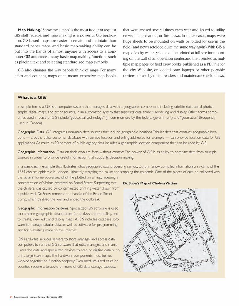
In a classic early example that illustrates what geographic data processing can do, Dr. John Snow compiled information on victims of the1854 cholera epidemic in London, ultimately targeting the cause and stopping the epidemic. One of the pieces of data he collected wasthe victims’ home addresses, which he plotted on a map, revealing aconcentration of victims centered on Broad Street. Suspecting thatthe cholera was caused by contaminated drinking water drawn froma public well, Dr. Snow removed the handle of the Broad Streetpump, which disabled the well and ended the outbreak.
Geographic Information Systems. Specialized GIS software is usedto combine geographic data sources for analysis and modeling, andto create, view, edit, and display maps. A GIS includes database soft-ware to manage tabular data, as well as software for programmingand for publishing maps to the Internet.
GIS hardware includes servers to store, manage, and access data;computers to run the GIS software that edits manages, and manip-ulates the data; and specialized devices to scan or digitize data or toprint large-scale maps.The hardware components must be net-worked together to function properly. Even medium-sized cities orcounties require a terabyte or more of GIS data storage capacity.
Dr. Snow’s Map of Cholera Victims

TAKING AN ENTERPRISE APPROACH
An enterprise GIS approach enables public agencies toincrease efficiency by sharing the cost of GIS technology andof framework GIS data to meet the specific informationrequirements of every department. It eliminates overlap andavoids the limitations caused by a narrow focus on a givenproject or problem. GIS technology allows organizations todevelop business applications that would not otherwise bepossible,but the best technical solution will be a failure if it isnot first and foremost a business solution. The followingexamples show how enterprise GIS capability allows organi-zations to create business solutions that are inexpensive buthighly effective.
Property Appraisal. Many county assessors have beendeveloping GIS-based computer-aided mass appraisal sys-tems (GIS/CAMA), resulting in fairer assessments and poten-
tially increased tax revenue. CAMA systems improve staff effi-ciency by combining recent high-resolution aerial photogra-phy with tax parcel maps to compare assessor records withthe actual extent and condition of the property.The technolo-gy also makes it easi-er for staff to discoverpreviously unnoteddevelopments oradditions; GIS/CAMAsystems can use digi-tal aerial photography from multiple years to automaticallyidentify possible structure modifications or additions. Thesesystems make appraisals more defensible by providing exten-sive data for objective analysis.
Site Analysis. Local governments analyze sites for a variety
of purposes.A city may need to determine the best place for
a clinic to serve the maximum number of nearby clients. A
utility may need to decide on the best location for a new
pumping station. A transit agency may need to analyze cus-
tomers of their park-and-ride lots. In each case, GIS provides
an effective tool for combining data from multiple sources,
processing the data,and presenting the results in tables,statis-
tics, or maps. In King County,Washington, for example, license
plate numbers recorded from each park-and-ride lot are used
to determine the addresses of the vehicle owners, which are
then plotted on a map to depict the distribution of the lot
users (see Exhibit 1). Transportation planners then use the
maps to plan for new lots or to adjust bus service.
Web Mapping Applications. One of the most significant
recent GIS developments is putting basic, user-friendly GIS
capability in the hands of everyone in the agency, and the
public as well.While desktop GIS software requires significant
computer capability,GIS-based Web mapping applications use
Internet mapping system (IMS) software that performs the
map request and display processing on a central server and
then displays the results on any computer with a Web browser.
Web mapping application costs are basically fixed,so there
is no additional cost involved in making the application wide-
ly available — even to the public. Of the 39 counties in
Washington, 30 have public Web mapping applications, along
with seven cities and one regional agency. For context,
King County, Washington maintains a suite of Web mapping
applications that collectively had 2.2 million user sessions in
2007.This represents more than 6,000 public user sessions per
February 2009 | Government Finance Review 25
GIS changes the way people
think of maps.

26 Government Finance Review | February 2009
Exhibit 1: Home Locations of Park-and-Ride Lot Users in King County

day. The result has been fewer people visiting county offices
or calling county staff for basic information about the county,
its services, or their property.
Data Processing and Reporting. Some GIS-based applica-
tions do not rely on maps. A utility department may need to
know per capita water consumption by city council district,or
the police department may need to know crime rates by zip
code. With appropriate data, GIS processing provides these
types of reports quickly. GIS can also generate property owner
or business mailing lists easily,based on location-based queries.
Other GIS-based applications include crime mapping,emer-
gency dispatch and routing for e911, maintenance and work
order management systems, flood plain mapping, natural
resources management,and real estate portfolio management.
BUDGETING AND FINANCE
As GIS capability has matured,applications to support pub-
lic budgeting and finance business needs have become com-
mon. In King County, the Finance and Business Operations
Division accounted for 1.65 percent of staff in 2007, but 1.75
percent of Web mapping application user sessions.The coun-
ty’s Office of Management and Budget represented 0.65 per-
cent of total staff, but 1.14 percent of total user sessions. The
county’s budget and finance staff use GIS at a rate compara-
ble to or greater than departments.Specific examples of budg-
et- and finance-related GIS applications include looking up
property tax histories,analyzing tax and utility payment delin-
quency, and mapping capital improvement projects for budg-
et development.
Many states have implemented GIS-based online applica-tions to look up tax rates.The state of Washington Departmentof Revenue’s Online Tax Rate Lookup Tool (at http://dor.wa.gov/content/findtaxesandrates/salesandusetaxrates/looku-pataxrate/) allows residents or businesses to determine theappropriate sales tax rate for a specific location based on acity name, street address, or zip code, or by indicating a loca-tion on an interactive online map.This, like all web-mappingapplications, reduces calls to agency staff while providing res-idents and businesses with a more useful service.
Another finance-related business use for GIS is complyingwith Governmental Accounting Standards Board StatementNo. 34, Basic Financial Statements — and Management’sDiscussion and Analysis — for State and Local Governments.
GASB 34 requires that local governments establish mecha-nisms to report on their infrastructure value,depreciation,andmanagement practices.Even without GASB 34,the aging infra-structure of cities and counties is a financial challenge and apolitical problem that will only grow with each passing year.GIS has proven to be an effective tool for managing municipalasset inventories, modeling valuations, and planning mainte-nance or replacement of assets.
FUNDING FOR MUNICIPAL GIS
Most agencies implement GIS as a capital project,based ona needs assessment,cost-benefit analysis, and strategic imple-mentation plan. Start up costs typically include acquiringhardware and software, developing or acquiring frameworkGIS data, system integration, and assembling a small staff tooperate and maintain the system.
February 2009 | Government Finance Review 27

28 Government Finance Review | February 2009
A single sponsor department such as planning or publicworks often provides GIS operation and maintenance. But asGIS use spreads outside the sponsor department, many agen-cies recognize that GIS should be organized as an enterpriseservice and funded by the individual departments that bene-fit from the services.The current trend is for municipal GIS tobe organized as a stand-alone division, or as a section withinthe agency’s information technology division. Often, a GISoversight committee provides ongoing strategic direction andfunding support, and a GIS technical committee representsthe needs of GIS end-users and business clients.
The largest component of a GIS management office budgetis labor.A small city or county GIS may have a staff of just oneor two people, while a large city or county with a populationof more than one million might have more than 20 people inits GIS management office. GIS managers and other seniorstaff typically have at least a bachelor’s degree from a univer-sity GIS program.Some schools now offer a master’s degree inGIS management programs.The GIS Certification Institute (atwww.gisci.org) also provides a GIS Certified Professional des-ignation for those who have demonstrated a defined level ofeducation, experience, and professional involvement.
The typical GIS budget may include the purchase of newsoftware and should always include software license mainte-nance to ensure that GIS staff and users have access to soft-ware updates and vendor support. GIS desktop software typi-cally requires a license for each user. IMS software is relatively expensive, compared with desktop software, but itenables basic GIS capability to be provided to many businessend-users without the cost of individual licenses. Another way to control the cost of desktop GIS software is enterpriselicense management — pooling software licenses, with users“checking out” licenses only when they need them. Becausemany users access GIS software only a few hours each week,enterprise license management allows an agency to meet itsneeds with a smaller number of licenses and at reduced cost.
The GIS budget will also include hardware costs. Desktopcomputer capability has increased, and most office comput-ers can now run GIS software. However, GIS staff will still ben-efit from computers that have higher processing speeds andgreater storage capacity because of the intense processinginvolved with data maintenance, application development,and analytical processing. Many organizations replace GISdesktop computers every two or three years, and then allo-
URISA
The Urban and Regional Information Systems Association
(URISA, at www.urisa.org) provides extensive educational
resources for managers who are responsible for implementing
enterprise GIS or managing its ongoing operation. Many of
these resources can be of value to finance and budget officers
who would like to learn more about the benefits of imple-
menting GIS and strategies to minimize start-up and opera-
tional costs.
A source for additional examples of GIS applications is the
URISA Journal (http://urisa.org/urisajournal), which contains ref-
ereed articles and reports about GIS research and state-of-
the-art GIS applications. Many URISA chapters publish online
newsletters (for example, the Washington State chapter
newsletter, The Summit, at http://www.waurisa.org/thesummit/)
with articles that describe local agencies GIS applications and
enterprise GIS case studies.
URISA holds an annual conference that attracts GIS profes-
sionals and users from around the world, as well as a GIS
Street Addressing Conference that focuses on street address-
ing standards and integrated emergency dispatch. Other
URISA specialty conferences focus on topics such as
GIS/CAMA, GIS for public health, GIS for transit, and public
participation GIS. In addition, URISA chapters in many states
and provinces hold their own annual conferences.The associa-
tion also provides workshops and publications on the use of
GIS for asset management.
URISA’s new flagship educational offering is the URISA
Leadership Academy.This week-long program, the only
geospatial technology leadership training program of its type, is
tailored for agency leaders and managers.
URISA also publishes books, quick study guides, and confer-
ence proceedings, in addition to its flagship URISA Journal.
Recently, URISA helped to form the Coalition of Geospatial
Organizations (COGO) with other GIS-related professional
and industry organizations.The primary purpose of COGO is
to formulate policy positions and to coordinate the develop-
ment of strategies to address key GIS-related issues at the fed-
eral, state, and local levels.

cate them to other staff. Other hardware will also be needed,including application and data servers, data storage devices,plotters, scanners, and sometimes laptops and GPS equip-ment for field data capture. The GIS management officeshould develop a plan that designates equipment replace-ment cycles with projected future costs.This plan can be usedto spread out replacement of expensive items over multipleyears to minimize budget cost spikes.
Once GIS has been developed, most of the data is main-
tained within the agency, with one major exception: aerial
imagery. Aerial imagery is a key component of municipal
GIS, providing locational context for other GIS data and
visual detail that supports many users.However,aerial imagery
must be replaced at least every two to
three years to provide coverage of new
subdivisions and infrastructure, and
changes to natural features, a well as
enabling GIS/CAMA change detection.
The GIS budget should include an
imagery replacement plan to coordinate
these costs with the equipment replace-
ment plan, or to set aside funds in an
imagery replacement reserve.
GIS funding varies from agency to
agency. Some organizations fund GIS
within the budget of a sponsor depart-
ment. These departments are usually
early adopters of GIS and have stable funding sources. Other
agencies treat GIS as a general government function
supported by the general fund. Because many agencies have
structural limits to the growth of their general funds, GIS
competes with many general government services in this
scenario. A growing number of agencies treat GIS as an
enterprise or internal service fund, with support from all
departments based on a funding formula tied to the level of
service provided.
There are many innovative examples of local governments
applying concepts such as costing government services,alter-
nate service delivery, and intergovernmental service sharing
to minimize GIS costs and to create more GIS capability. For
example, Chester County, Pennsylvania
(at www.chesco.org/ gis), and Pierce
County, Washington (at http://matter-
horn.co. pierce.wa.us/gis/), each pro-
vide basic GIS services to towns and
cities within their jurisdictions to gener-
ate revenue for the counties and to
reduce the cost of GIS capability for
smaller jurisdictions. Chester County
manages a GIS consortium that pro-
vides GIS services to townships,utilities,
and school districts for a tiered annual
fee.Pierce County provides local public
agencies with secure access to its GIS
February 2009 | Government Finance Review 29
There are many innovative
examples of local governments
applying concepts such as costing
government services, alternate
service delivery, and intergovern-
mental service sharing to mini-
mize GIS costs and to create
more GIS capability.

30 Government Finance Review | February 2009
data and applications for an annual subscription fee.The
King County GIS Center in Seattle (at www.kingcounty
.gov/gis) operates on an entrepreneurial basis,generating
5-10 percent of its annual revenue by providing a wide
variety of GIS services to outside agencies. King County
GIS services include Web application hosting,application
development,custom mapping,and GIS training for cities,
counties, regional agencies, and the state of Washington.
CONCLUSION
The U.S.Department of Labor lists geospatial technology
as one of 14 high-growth industries for the next decade.
GIS will be integrated into industry, commerce, and edu-
cation,paralleling the continued spread of enterprise GIS
capabilities throughout city, county, and regional agen-
cies. This mission-critical enterprise tool can be used in
many ways to manage operations and to maximize the
benefits of an organization’s unique geographic assets. ❙
Note
1.U.S. Department of Labor,“The President’s High Growth Training
Initiative,”http://www.doleta.gov/BRG/JobTrainInitiative/#
TargetedIndustries.
GREG BABINSKI is the finance and marketing manager for the
King County GIS Center in Seattle, Washington, where he has
worked since 1998. Before that, he was GIS Mapping Supervisor
for the East Bay Municipal Utility District in Oakland, California.
Babinski holds a master’s degree in geography from Wayne
State University, and he is a certified GIS professional (GISP).
He is also treasurer of URISA, the association for geospatial
professionals, as well as serving on the City of Mercer
Island, Washington, Utility Board. or more of GIS data
storage capacity.
GIS technology allows organizations to develop
business applications that would not otherwise
be possible, but the best technical solution will
be a failure if it is not first and foremost a
business solution.
Why Become a CPFO?
Vivian McGettigan, MBA, CPA, CPFO, Director of Finance for Fauquier County and Public Schools
Government Finance Officers Association
Financial Reporting
and at the annual GFOA conference.