gis enterprise geoportal project: software recommendations ... · doa has a statutory duty under...
TRANSCRIPT

GIS Enterprise Geoportal Project: Software Recommendations Report
October 3, 2014

CONTENTS
EXECUTIVE SUMMARY ......................................... 3
1 INTRODUCTION ............................................... 4 Project Purpose ...................................................................................................................................... 4 Project Scope .......................................................................................................................................... 5 Wisconsin Geospatial Data Context ....................................................................................................... 6 Wisconsin Geoportal Needs ................................................................................................................... 8 Project Logistics ...................................................................................................................................... 9
2 PROJECT EXECUTION ..................................... 12 Requirements Phase ............................................................................................................................. 12 Initial Product Evaluation Phase ........................................................................................................... 13 Product Proof-of-Concept Testing Phase ............................................................................................. 14
Product 1: Esri Geoportal Server ................................................................................................... 14 Product 2: CKAN ............................................................................................................................. 16
3 RESOURCE NEEDS ANALYSIS ............................. 18 Geoportal Governance Needs .............................................................................................................. 18
Geoportal Roles & Responsibilities ................................................................................................ 19 Geoportal Operations and Maintenance Estimates ............................................................................. 20
Geoportal Service Estimates .......................................................................................................... 21 Other Operation and Maintenance Considerations ...................................................................... 22 Geoportal Funding Model .............................................................................................................. 23
4 RECOMMENDATIONS ....................................... 24 Geoportal Product Choice .................................................................................................................... 24 Lessons Learned ................................................................................................................................... 24 Next Steps ............................................................................................................................................. 25
APPENDICES ................................................... 26 Appendix A: Project Charter ................................................................................................................. 26 Appendix B: GeoNetwork Geoportal Evaluation Checklist .................................................................. 32 Appendix C: CKAN Geoportal Evaluation Checklist .............................................................................. 33 Appendix D: Voyager Search Geoportal Evaluation Checklist .............................................................. 34 Appendix E: Esri ArcGIS Online Geoportal Evaluation Checklist .......................................................... 35 Appendix F: Esri Geoportal Server Evaluation Checklist ...................................................................... 36
2

EXECUTIVE SUMMARY
This document examines Wisconsin stakeholder needs and makes software recommendations for a Department of Administration (DOA) Division of Enterprise Technology (DET) enterprise geoportal system. Wisconsin is currently one of only nine states without a central state geospatial geoportal to ease the discovery, acquisition, and use of geospatial data and land information. DOA has a statutory duty under Wis. Stats. Section 16.967(3), to “. . . serve as the state clearinghouse for access to land information.” An enterprise geoportal could fulfill this duty, by facilitating the acquisition and efficient use of geospatial data. Recommendations Recommendation #1: DOA charters a Geoportal Implementation Plan Project, charged with the
following: Engage with LION, SAGIC, and the stakeholder community in the Implementation Planning •
process Propose governance plan requirements for the new geoportal system • Investigate and provide specifications for implementation of CKAN as a geoportal service • Develop a plan to fund the $1,200 to $1,500 or more initial costs and the $2,000 to $3,000 •
or more per month of ongoing costs Further investigate and recommend necessary employee resources to operate, maintain, •
customize and support the system for the first year Report to DOA management with a proposed Geoportal Implementation Plan by the end of •
April , 2015 Recommendation #3: DOA identifies an interim management-level project sponsor for a Geoportal
Implementation Plan Project Recommendation #4: DOA pursue the replacement of the GIO position in a timely manner to coincide
with subsequent efforts by Geoportal Implementation Plan work group Recommended Timeline: October 31, 2014 DOA charter and approve Geoportal Implementation
Plan Project October 31, 2014 – March 31, 2015
Weekly Geoportal Implementation Plan Project meetings and stakeholder engagement
April, 2015 Geoportal Implementation Plan Project team deliver report to DOA management
2015 or 2016 Begin a project to develop a new and improved Wisconsin Geospatial Data Repository
3

1 INTRODUCTION
This document examines Wisconsin stakeholder needs and makes recommendations on a solution for a Department of Administration (DOA) Division of Enterprise Technology (DET) enterprise geoportal. The conclusions presented suggest the need for a geoportal which will make Wisconsin’s government geospatial information a true enterprise asset. The mission of the Geographic Information Office within DOA is to facilitate coordination, promote efficient data sharing, maintain effective and robust geographic information systems, promote strategic state enterprise geospatial goals, and thereby better enable enterprise spatial information utilization. Briefly stated, an enterprise geoportal is essential to fulfilling the mission of the GIO and leveraging Wisconsin’s enterprise spatial data assets across state and local agencies. Discovery and access to government geospatial data is in the best interest of our communities and the state. Applications of geospatial data include economic development, social services delivery, public safety and emergency management, agriculture, natural resources management, and transportation. Unfortunately, geospatial data from a majority of Wisconsin’s government custodians is often difficult to discover, access, and utilize. According to Wis. Stats. Section 16.967(3), DOA is charged to “. . . serve as the state clearinghouse for access to land information.” An enterprise geoportal could fulfill this duty, by facilitating the acquisition and efficient use of geospatial data. Generally speaking, a geoportal serves a few key purposes:
Provides access to priority geospatial data through a web-based data discovery and access tool • Serve as a GIS community curated source of common and in-demand geospatial metadata • Systematic search and discovery capabilities allowing for filtering by or identification of a •
resource’s official agency custodian, technical documentation, time period represented, and area of coverage
Sufficient administrative capabilities to allow for periodic assessment, monitoring, and update of •content
Extensible functionality to allow for potential addition of advanced or differing capabilities •based on user feedback
Project Purpose The purpose of this project was to investigate product solutions and implementation requirements for enterprise geoportal services. This report documents the efforts of a workgroup which was assembled to examine how several products meet user needs regarding geospatial data storage, discovery, and access. The workgroup was charged with producing recommendations for implementing a managed geoportal solution for use by state and partner agencies. Those workgroup recommendations and the basis for them comprise this report.
GEOPORTAL A Web portal used to discover and access geospatial data and related services from one or more spatial data repositories.
4

Project Scope It is important to recognize that this recommendations report focuses primarily on geoportal software and infrastructure recommendations and is not an implementation project. A separate implementation project might follow this report, as this workgroup recommends. This report only features geoportal product recommendations, descriptions of geoportal maintenance estimates, and general governance requirements. Figure 1 below illustrates the scope of this software recommendations report. This software recommendations project might be considered a first step toward an implementation plan that will address geoportal related issues in detail, such as government-to-government data sharing agreements. According to the State Agency Geospatial Information Committee, data sharing and geospatial coordination during emergency operations and normal operations are top priorities for those working with GIS data. Because this report focuses on software recommendations, strategic issues such as data sharing are out of this project’s scope. Thus, they would be better addressed in a separate Geoportal Implementation Plan Project, which the workgroup recommends follow this report.
March 2014 - October 2014
1 2 3 Geoportal Software
Recommendations Report
2Q 2015 - 4Q 2015
October 2014 - 1Q 2015
Geoportal Implementation
Plan Development
Execution of Geoportal
Implementation Plan
Unsecured
Data
1Q 2016 - 3Q 2016
Secured Data
TBD
1 2 3 Repository
Recommendations Report
TBD
Repository Implementation
Plan Development
Execution of Repository
Implementation Plan
Unsecured
Data
TBD
Secured Data
Prior DOA
Repository Work
2008-2009 Figure 1. Scope of this report and potential future projects
5

To reiterate, this workgroup’s emphasis was on geoportal software recommendations. Nevertheless, the workgroup was mindful of the relationship that often exists between a geoportal and a repository. A repository is a central IT infrastructure piece necessary for the storage and provision of enterprise spatial data assets. Considering an enterprise repository was outside of this project’s scope. However, the workgroup members were informed by their experiences with spatial data repositories, including what has been referred to as the “Wisconsin Spatial Data Repository.” The Wisconsin Spatial Data Repository was a DET project that began in 2008. That project established the framework for a DET geospatial data repository but never led to the implementation and widespread use of that repository infrastructure. The project team recommends that more work on an Enterprise Repository should be done in the near future. This includes dealing with the issues of governance, roles, responsibilities, service offering definitions, costs and access to both unsecured and secured data. Wisconsin Geospatial Data Context Wisconsin has a long and proud legacy as a leader in the application of geographic information systems (GIS) within government. This history and current investigative work are the foundation for the project described in this report.
Some state agencies and counties began developing processes and procedures to use digital •versions of spatial data sets for planning and analysis in the early 1980’s.
In 1989, the Wisconsin Land Information Program and the Wisconsin Land Information Board •were created by Wisconsin Act 311, to establish a mechanism for land records modernization statewide.
In 1997, the Wisconsin Land Council2 was created, and attached to the Department of •Administration, to identify state goals and priorities and make recommendations to the Governor for implementation of Comprehensive Planning.
In 1999, the State Cartographer’s Office introduced Version 2 of its WISCLINC Clearinghouse •followed by a year-long series of FGDC-funded workshops on geospatial metadata development and publishing through a Clearinghouse.
In 2005, the State of Wisconsin hired its first Geographic Information Officer (GIO), located in •the Division of Enterprise Technology in the DOA. The GIO was given broad responsibilities, which included facilitating the coordination of GIS activities among stakeholder groups, encouraging the adoption of appropriate standards and data sharing policies, and identifying strategic directions for statewide GIS.
In 2005, the State Cartographer’s Office introduced its final version of WISCLINC—a voluntary •clearinghouse effort hosting metadata and links to GIS data housed elsewhere in the state.
In 2006, the GIO, through the “Wisconsin Enterprise GIS (WEGIS) 2006-2007 Business Plan” •announced an initiative for an enterprise GIS data repository and enterprise web mapping infrastructure and services.
1 https://docs.legis.wisconsin.gov/1989/related/acts/31 2 Statutory Sections 15.07 (16), 16.966, 16.967. Repealed in 2003.
6

In 2008, the DOA Division of Intergovernmental Relations partnered with the State •Cartographer’s Office to utilize the National States’ Geographic Information Council ‘s (NSGIC) GIS Inventory tool as part of the annual County Land Information Office Survey to update the state’s understanding of county-level GIS data holdings with a subsequent report in 2009.3
In 2012, the State Cartographer’s Office made known their intention to retire the WiscLINC •website in lieu of a UW-focused spatial data portal (in partnership with the UW-Madison Robinson Map Library) to provide access to county GIS data (much of which is restricted to academic use) to faculty, staff, and students.
State and National Trends National organizations have long advocated for the use of federated repositories and spatial data infrastructures,4 and geoportals. Many states have successfully implemented geoportals.5 Wisconsin is currently one of the nine states without a state geoportal. States need a system for discovery and access to geospatial data sets and associated services. Modern state geoportals provide effective online access through keyword, thematic, and map-based searching options. Using a geoportal to index related information, such as online map applications, federated external data sources, and other geo-services provides the most complete geoportal implementation. This is observed as a best practice in other state implementations, which were researched by this workgroup. Benefits of Free and Open Data In examining the return on investment of a potential geoportal, future decisions take into account the value of free and open government data. There are cases where data managed by government agencies is not available to the public, for reasons such as privacy and security. In the case of geospatial data, this workgroup suggests that publicly funded non-sensitive geospatial information be classified as free and open data, in accordance with best practices established by the National States’ Geographic Information Council.6 Backed by extensive research,7 the Minnesota-based organization MetroGIS argues that adopting a free and open data policy would have the following benefits:
Saves money, as their research has shown that the practice of charging for data has not proven •to be profitable
Data should be thought of as a public asset and therefore made more openly available to the •residents that are being served
Increases transparency and shows a “willingness to provide good public service” • Promotes economic growth, especially in a “digital economy” where businesses depend on data • such as this to make decisions • Allows for innovation—providing the data in the open and in open formats means that it is more • accessible for anyone to use in novel and innovative ways8 •
3 http://www.doa.state.wi.us/Documents/DIR/Land_Information/Land_Information/FINAL_County_GIS_Inv_Report_May2009.pdf 4 http://www.nsgic.org/public_resources/Strategic-Framework-for-NSDI_Final-050109.pdf 5 http://www.nsgic.org/geospatial-maturity-assessment 6 http://www.nsgic.org/public_resources/NSGIC_Data_Sharing_Guidelines_120211_Final.pdf 7 MetroGIS Data Producers Work Group (October 23, 2013). MetroGIS: Free & Open Access to Data. Retrieved August 11, 2014, from http://metrogis.org/MetroGIS/media/gis-documents/publications/
7

Wisconsin Geoportal Needs In our state there are several instances where the ownership, use, and management of spatial data assets pose challenges. These are issues which can be addressed with a geoportal. In general a geoportal would be useful for identifying geospatial data issues that could be solved by the data producers themselves, the GIS community or through other systems, like a geospatial repository system. Elaborated below are some of the general spatial data management challenges that might be resolved with a geoportal solution. Access to Geospatial Data Not Currently Accessible to the Public Delivering geospatial information to the public is a financial commitment that some government business operations cannot justify. Perhaps leveraging services and data from outside sources where possible, agency business areas are creating and utilizing GIS datasets internally, but the resulting geospatial data assets are not made accessible outside a given program area. For example, state agencies as large as the departments of Public Instruction and Workforce Development, with countless “locatable” assets and customers dispersed across the state, have not yet developed infrastructure that makes these spatial data holdings accessible to others. Identification of Geospatial Datasets without Formal Stewardship Many datasets have been produced at state agencies out of project-based need, with no formal agency assigned as custodian. There is an enterprise-wide need to be able to access datasets without formal stewardship. A geoportal will help identify these datasets without formal stewardship. Identification of Datasets Requiring Aggregation Some datasets with regional and statewide value are housed and maintained by county and municipal custodians, but not widely accessible. Examples of data potentially critical to state and regional operations, include address points, land parcels (property ownership boundaries), zoning, public lands, building footprints, LIDAR-based elevation data, aerial imagery and accurate localized data on transportation, hydrography and utilities. These data are currently assembled by state agencies on an ad-hoc project basis but should be aggregated into standardized statewide layers, reducing redundancy and increasing return on investment on these detailed local government data. Identification of Datasets that are Stored Redundantly Because spatial analysis and mapping with GIS software has become core to many state agency business areas, agencies tend to warehouse the geospatial data they use repeatedly but have gathered from elsewhere. Identical copies of geospatial data are often stored in individual databases in municipalities, counties and state agencies, consuming space and resources. These duplicate copies represent statewide roads, water bodies, waterways, public lands, administrative boundaries, place names, imagery, and many others. State imagery alone can occupy terabytes of space. In some state agency cases identical copies of large datasets are housed on neighboring servers at the state data center. This is not only an issue
8 MinnPost. (December 11, 2013). MetroGIS Recommends 7 Counties Make Geospatial Data Free And Open. Retrieved August 11, 2014, from http://www.minnpost.com/politics-policy/2013/12/
8

because of the duplications in resourcing, space and cost. It can also cause problems with regard to accuracy and currency reducing efficiency. Identification of the authoritative source for a particular dataset A geoportal can identify what data sources are determined by the GIS community to be the authoritative data source for a particular use. To make this identification process work well there will have to be clear definitions and processes established by the GIS community on what constitutes an authoritative dataset for a particular subject area. Fulfilling Statutory Responsibilities for Land Information Under the statues governing DOA’s Land Information Program (s. 16.967), DOA is to “serve as the state clearinghouse for access to land information,” and “maintain and distribute an inventory of land information available for the state.” Act 20, the state’s biennial budget for the years 2014-2015, requires DOA to plan and create a statewide digital parcel map, which will require aggregating local-level geospatial datasets (see “Identification of Datasets Requiring Aggregation” section above) and making those resources available and accessible to the public. Project Logistics DET Charter and Stakeholder Identification The charter for this recommendation project was initiated in January 2014. It was approved by DET and the project began in February of 2014. The project charter appears as Appendix A. To identify stakeholders, the workgroup identified a variety of stakeholder organizations. The groups listed below illustrate the diversity of stakeholders who aim to leverage and maximize the benefits of geospatial information assets and their efficient application. Some of these groups are focused on the geospatial discipline, while others utilize GIS as part of their core organizational business.
Association of Public-Safety Communication •Officials – WI Chapter
Wisconsin County Surveyors Association • Wisconsin Geographic Information •
Coordination Council Wisconsin Land Information Officers Network •
(LION) Wisconsin Land Title Association •
Wisconsin Real Property Listers • Wisconsin Register of Deeds • Wisconsin Society of Land Surveyors • Wisconsin State Agency Geospatial •
Information Committee (SAGIC) Wisconsin State Cartographer's Office (SCO)•
Project Team Voting members for this project were selected from three key stakeholder groups. The project team consisted of two representatives from LION, two from SAGIC, one from SCO, and several auxiliary (non-voting) members listed in the table on the following page.
9

Project Team Members
Voting Member Organization Role
Al Brokmeier Kenosha County – LION County LIO Stakeholder Sara McCurdy Polk County – LION County LIO Stakeholder Mitch Moline DOT – SAGIC State Agency Stakeholder Jerry Sullivan DNR – SAGIC State Agency Stakeholder AJ Wortley SCO Community Outreach and Technologies Expert
Auxiliary Members Curt Pulford GIO Project Manager (until June 2014) Lee Samson GIO Architecture and Technical Support,
Project Manager (after June 2014) William Cozzens Waukesha County – LION County LIO Stakeholder Peter Herreid WLIP WLIP Grant Administrator Davita Veselenak WLIP WLIP Staff and Communications Jaime Stoltenberg UW-Madison Cataloguing and Acquisitions Martin Goettl UW-Eau Claire Data Access and Data Management
Project Schedule
Task Name Duration Start Finish
Establish Stakeholder Team 2 weeks Mon 2/24/14 Fri 3/7/14 Stakeholder Business Requirements 4 weeks Mon 3/10/14 Fri 4/4/14 Geoportal (discovery) requirements Discuss/refine list Business requirements document Evaluate Wisconsin Spatial Data Repository 1 week Mon 5/4/14 Fri 5/9/14 Evaluate Geoportal Products On Requirements 6 weeks Mon 5/10/14 Fri 6/13/14 Build checklist from requirements Review geoportal Server Review GeoNetwork Review ArcGIS Online (AGOL) Review Voyager Compile findings Selection of test products Geoportal Product Proof-of-Concept(s) 6 weeks Mon 6/15/14 Fri 7/25/14 Load product 1 Test product 1 Load product 2 Test product 2 Review products, rate as tested Document product recommendation Geoportal Governance/Resource Needs Review 2 weeks Mon 7/21/14 Fri 8/1/14 Review data/metadata tasks Document governance requirements Estimate resource needs Document resource recommendation Final Report Draft 9 weeks Mon 8/4/14 Fri 10/3/14
10

11

2 PROJECT EXECUTION
Requirements Phase The project team worked collaboratively to define geoportal business use cases, followed by deriving functional/non-functional requirements desired in a geoportal, as shown in the tables below. Geoportal Business Use Cases
Use Case Name Description
Use Case 1
Orient new state agency employee
Provide all relevant resources through a single maintained source
Use Case 2 Access a repository through a geoportal Use a geoportal to access a repository Use Case 3 Find data by search Simple keyword search
Spatial search Federated search Advanced options for experts Smart matching and ranking Thesaurus service Search results are simple to understand yet contain detail for power users
Use Case 4 Find data by browsing Find data without searching Filter within category Classification and relationships
Use Case 5 Create a map Use preview service Provide integration points for map viewer platforms
Use Case 6 Share a resource Share resource location or resource Use Case 7 Preview service that shows basic
version of map A demonstration interactive map that provides some utility, but can be easily accessed by the lay person
Use Case 8 Access individual county datasets—parcels and other locally created "Statewide Framework Data Layers" GIS data created with WLIP funding
A portal to point individual local datasets and a repository, if local GIS datasets are not easily accessible, that avoids the hassle of having to contact individual county staffers and to sign multiple license agreements.
Use Case 9 Access aggregated, state-created datasets—parcels and other statewide aggregated layers from local GIS data
Statewide parcel layer and other layers aggregated from local data
Use Case 10 Geospatial portal as a broker (middleman)
Search a remote geospatial portal or endpoint
Use Case 11 Download data Allow the DOA portal to act as a remote endpoint Use Case 12 Serve as point of contact for county
resources Direct state agency requests and inquiries regarding county layers first through a DOA portal
Use Case 13 Backup facility A secondary location for critical data in the event of an emergency
Use Case 14 Ability to monitor change in data submittal/collection
Reporting
12
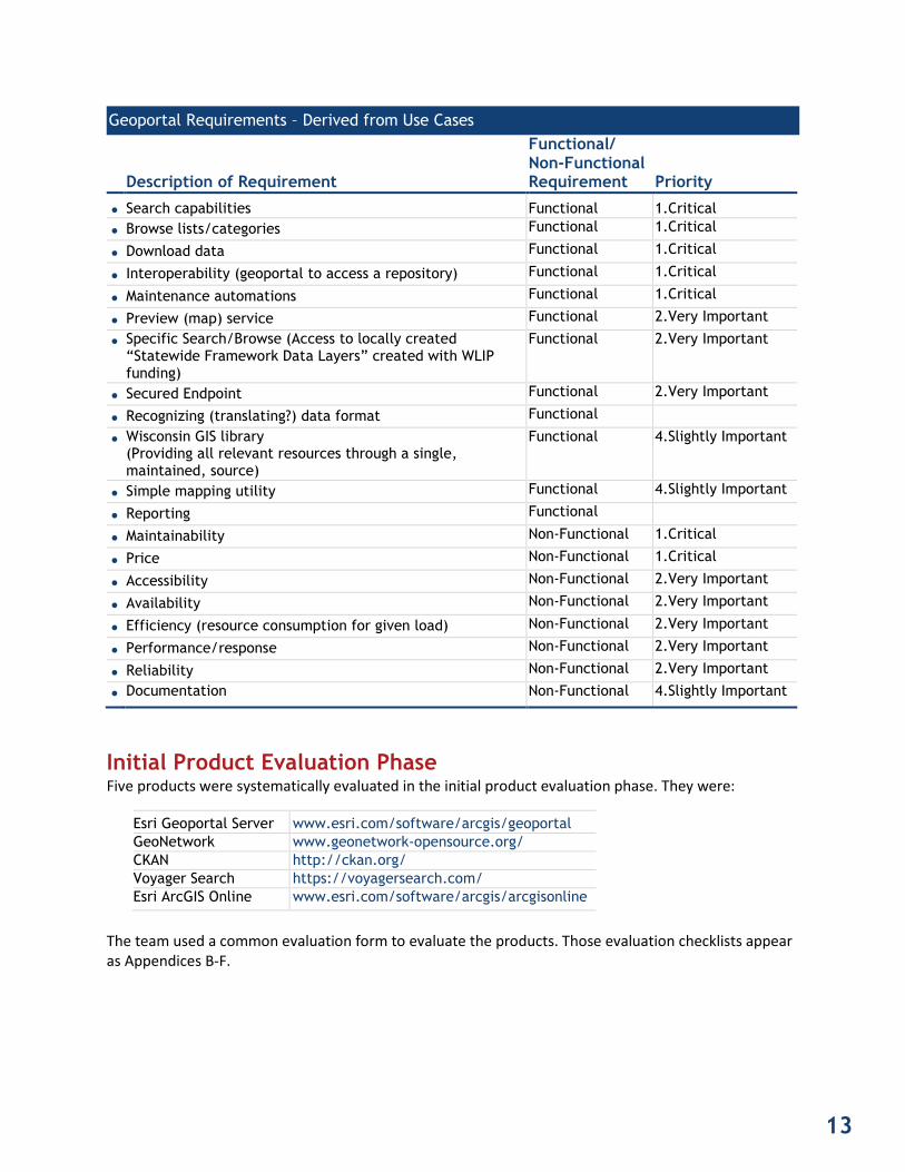
Geoportal Requirements – Derived from Use Cases
Description of Requirement
Functional/ Non-Functional Requirement Priority
• Search capabilities Functional 1.Critical • Browse lists/categories Functional 1.Critical
• Download data Functional 1.Critical
• Interoperability (geoportal to access a repository) Functional 1.Critical
• Maintenance automations Functional 1.Critical
• Preview (map) service Functional 2.Very Important
• Specific Search/Browse (Access to locally created “Statewide Framework Data Layers” created with WLIP funding)
Functional 2.Very Important
• Secured Endpoint Functional 2.Very Important
• Recognizing (translating?) data format Functional
• Wisconsin GIS library (Providing all relevant resources through a single, maintained, source)
Functional 4.Slightly Important
• Simple mapping utility Functional 4.Slightly Important
• Reporting Functional
• Maintainability Non-Functional 1.Critical
• Price Non-Functional 1.Critical
• Accessibility Non-Functional 2.Very Important
• Availability Non-Functional 2.Very Important
• Efficiency (resource consumption for given load) Non-Functional 2.Very Important
• Performance/response Non-Functional 2.Very Important
• Reliability Non-Functional 2.Very Important
• Documentation Non-Functional 4.Slightly Important
Initial Product Evaluation Phase Five products were systematically evaluated in the initial product evaluation phase. They were:
Esri Geoportal Server www.esri.com/software/arcgis/geoportal
GeoNetwork www.geonetwork-opensource.org/ CKAN http://ckan.org/ Voyager Search https://voyagersearch.com/ Esri ArcGIS Online www.esri.com/software/arcgis/arcgisonline
The team used a common evaluation form to evaluate the products. Those evaluation checklists appear as Appendices B-F.
13

Product Proof-of-Concept Testing Phase In the proof-of-concept phase, two products that were evaluated as most viable by voting members were installed, tested, and subject to hands-on evaluation. About Geoportal Proof-of-Concept Evaluation Process To evaluate the contributor perspective, project members were given some instructions on how to load metadata on the systems. They were then given the ability to add, delete or modify metadata as the wished. We tried to load metadata that included a variety of resource references. This includes links to downloadable data, web services and web applications. Members of the project team were able to evaluate the user perspective by searching for and listing data available on the systems. For both systems users were able to do keyword searches and dataset browsing. Both of these products have metadata harvesting tools. These are tools that can take a large set of files or metadata in XML format and load them into the system as new metadata entries. We did not have time to thoroughly test these tools, but we did confirm that they should work for harvesting metadata if fully implemented. Product 1: Esri Geoportal Server Esri Geoportal Server is a free, open source product that enables discovery and use of geospatial resources including geospatial datasets, online applications, and Web service APIs. It allows organizations to publish metadata for their geospatial resources to facilitate user discovery and access. The geoportal Server supports federated connections to standards-based clearinghouse and metadata serving applications. Esri Geoportal Server functions well at searching for particular tags or keywords if provided and using a standard vocabulary. Standard search options are supported. Publishers and administrators can login and add new resource entries. This software does require that metadata contain particular keywords and attributes to enable
Figure 2. Esri Geoportal Main Page
14

appropriate indexing of resources. This implies that in some cases metadata from data custodians will require edited before loading into the system. Esri Geoportal Pros and Cons
Pros Cons
• Customizable • Some good tools for harvesting data • Open source
• Requires some editing of metadata to index the resource correctly
• May require multiple entries for the same data set with different access options (e.g. data download versus web service)
• Publisher role privileges are limited. Publishers require Administrator approval before changes are available to users.
Figure 3. Esri Geoportal search page 15

Product 2: CKAN CKAN is a data management system that makes data accessible—by providing tools to streamline publishing, sharing, finding and using data. CKAN is aimed at data publishers seeking to make their data open and available, such as national and regional governments, companies, and organizations. CKAN, unlike Esri Geoportal Server, was not designed specifically to be a geospatial data catalog but rather a catalog for any type of data. Add-on spatial extensions and some customizations were made by the workgroup in order to use CKAN as a geospatial data catalog. The software did not have the metadata entry tools provided by Esri Geoportal server and harvesting tools were not as extensive. It did allow for a more flexible organization and categorization of datasets and their associated resources. CKAN Pros and Cons
Pros Cons • Customizable • Open source • Flexible organization of datasets with multiple
access options • More flexible in general
• No direct metadata entry tools • Requires a bit more maintenance and
customization to operate as a geospatial catalog
Figure 4. CKAN main page
16

Figure 5. CKAN search page
17

3 RESOURCE NEEDS ANALYSIS
Geoportal Governance Needs This section forecasts the needs of a production geoportal system based on lessons learned and workgroup discussions during the proof-of-concept test by the workgroup’s GIS support team and the evaluation team. Both the Esri Geoportal and CKAN software will require the same level of governance. There will need to be a set of well documented policies, procedures, standards, and guidelines for operating and maintaining the system. These will be maintained by the GIS support team. A review board will be needed to review and update the policies, procedures, standards and guidelines and provide general oversight and feedback from stakeholders. Ideally this review board would consist of representatives of the major potential contributors to the geoportal as well as some primary stakeholder end-user representation. This may include but is not limited to state agency, local government, non-profit, academic and private sector representatives. Figure 6 displays a possible configuration for a geoportal management scenario.
Contributor
GEOPORTAL MANAGEMENT SYSTEM OVERVIEW
System policies, standards,
guidelines and procedures
Geoportal Repository Review Board
GIS Support Team
Contributes to
geoportal
Assists contributors
Reviews and updates system policies,
standards, guidelines
and procedures
Operates and maintains
system
Figure 6. Geoportal management system overview
18

The suggested GIS support team consists of DET staff working in the GIS area of the Division, other DET staff, the Geographic Information Officer, and DIR staff from the Land Information Program. The GIS support team in conjunction with the review board will be responsible for drafting initial policies, procedures and guidelines. It is recommended that, at minimum, the following policies, procedures and guidelines be developed before the system is put into production:
Establish Service Level Agreement for geoportal services, including: •• Service Description • Service Hours • Service Availability • Customer Support • Service Performance and reliability • Capacity
Metadata guidelines •• Guidelines for Titles, Descriptions, Keywords, Time period of content, Appropriate
technical documentation, and Authoritative custodian identification • Naming convention for files • Standard tag and keyword taxonomy for effective catalog entry Role-based policy for editors (publishers) and administrators • Roles and responsibilities documentation for: •
• Contributors: geospatial data producers that contribute data • GIS Support team members: Responsible for day-to-day maintenance, technical
development and enhancement, and security and sustainability of the system • Review board members: support policy development, contribute to periodic
assessment, provide oversight and solicit stakeholder feedback Geoportal Roles & Responsibilities The major roles of support staff should be defined and documented. This includes but is not limited to of roles of data contributors, GIS support team members, and review board members. Responsibilities for each of these roles should be clearly documented. One approach is to use a RACI matrix9 (Responsible, Accountable, Consulted, and Informed). The definitions for the key roles in a RACI matrix are:
(R) Responsible – Those who do the work to achieve the task. There is at least one role with a •participation type of responsible.
(A) Accountable (also known as approver or final approving authority) – The one ultimately •answerable for the correct and thorough completion of the deliverable or task, and the one who delegates the work to those responsible.
(C) Consulted – Those whose opinions are sought, typically subject matter experts; and with •whom there is two-way communication.
(I) Informed – Those who are kept up-to-date on progress, often only on completion of the task •or deliverable; and with whom there is just one-way communication.
9 http://en.wikipedia.org/wiki/Responsibility_assignment_matrix
19

Proposed RACI Matrix for Geoportal10
Responsibility Category Responsibility Contributors Support Team
Review Board
1
Content
Adding new metadata to geoportal for a new dataset
R, A
C
2 Content Assisting contributors with metadata entry
A R
3 Policies, procedures, standards and guidelines
Making an adjustment to metadata standards
C R A
4 Policies, procedures, standards and guidelines
Putting an new metadata standard in place
I R A
Geoportal Operations and Maintenance Estimates To operate and maintain the geoportal system, the workgroup recommends creating: 1) a development system and 2) a production system. Both Esri Geoportal and CKAN require some technical modifications to add or update certain functionality (e.g., add a new extension). There is a need to have a system on which to test changes before update of the production system. For the development system, this workgroup recommends something similar to but slightly better than the test systems employed for this project. For the production systems, it is recommended that the web server and application server components of the geoportal software be separated out. This means a geoportal will require at least two servers. As part of these estimates some initial and ongoing costs estimates are provided here. These are rough cost estimates provided to give an idea of the resource requirements for operations and maintenance for the system. A future Implementation Plan Project for the geoportal system is necessary to provide more detailed and accurate cost estimates.
10 This is a limited example of what a RACI matrix for a geoportal could look like. Any such potential governance mechanisms will need to be fully examined by the Implementation Plan Project team.
20

Geoportal Service Estimates Geoportal Server Needs Esri Geoportal CKAN Non-Production System (Web and Application Server in one)
1 x Windows Server 2008 R2 (64 bit) 2 CPUs, 8Gb RAM 80 Gb disk space
1 x Linux Server (SLES) 64 bit 2 CPUs,8Gb RAM 80 Gb disk space
Production System (Separate servers for Web and Application servers)
2 x Windows Server 2008 R2 (64 bit) 4 CPUs,8Gb RAM 100 Gb disk space
2 x Linux Server (SLES) 64 bit 4 CPUs,8Gb RAM 100 Gb disk space
To operate and maintain the systems, a support staff is required, with basic system administration skills for the particular operating system being used. Both products require some experience with the Apache web server and the Tomcat servlet engine. The recommended installation procedure for CKAN involves setting up Linux-style user using some accounts with that are only available to Linux users that have access to root-level privileges. This might limit who can assist with system support and development on CKAN systems.
Geoportal Staffing Needs Esri Geoportal CKAN
Support Staff Skills
Windows Administration Skills Experience with Apache, Tomcat
Linux Administration Skills Experience with Apache, Tomcat
Developer Skills
Java Enterprise Edition programming skills (e.g. Java Server Faces, JSP) HTML, CSS, JavaScript
Python development skills using the Pylons web framework HTML, CSS, JavaScript
Initial Install Time 4 – 8 hours 6 – 10 hours
For the CKAN system, the workgroup used the DOA standard Linux Server OS: SUSE Linux Enterprise Server (SLES). Unfortunately, there were no installation instructions for this OS provided by the CKAN developers. The team found that by using instructions for the CentOS version of Linux and compiling packages by hand we could get things working on SLES without a problem. Someone with developer skills may be needed to customize the sites. Necessary customizations would include everything from simple web layout changes to adding new functionality in the form of custom code or extensions. Esri Geoportal customization would require some knowledge of Java EE (Enterprise Edition) and CKAN customization would require Python and Pylons knowledge.
21

Total ongoing costs for the two geoportal products should be about the same. Esri Geoportal costs might be higher depending on what database is used to store some of the records.
Geoportal Cost Estimates – Initial Set Up
Esri Geoportal CKAN
Initial Staff Time11
Staff Time ($80/hour)
$320 - $640
$480 – $800
Ongoing (per month)12 Technical Costs
Non-production Server $ 433.42 Production Server $ 1,261.68 Disk Space ( 280 Gb) $ 137.20 Staff Time13 ($80/hour) Average of 0.75 hours / week $240.00 Total Ongoing $ 2,072.30
Other Operation and Maintenance Considerations To operate and maintain the geoportal it is necessary to commit at least one full time employee to this work for at least a year. This resource would be needed for the following tasks:
Basic operation and maintenance work that may take 1-2 or more hours per week • Technical assistance work for contributors and users of the system, requiring anywhere from 10-•
25 hours per week • Documentation – including the development of policies, procedures, standards and
guidelines • Act as the geoportal custodian – responsible for developing the technical environment
and database structure of the geoportal • Assistance with data entry by custodians and other contributors • Assisting users with searches – interactive or non-interactive • Preparation of datasets for sharing
Customization of the system could take anywhere from 0–5 hours per week • Maintenance will require periodic assessment of the overall collection with attention to: •
• Dataset lifecycle and necessary update frequency • Datasets superseded by higher quality or newer data
Maintenance will entail preservation of superseded or updated datasets • Maintenance will entail analysis of gaps in collection supported by business area demand •
11 Initial staff time does not include all the documentation and customization that may be needed 12 Ongoing costs based on July 10, 2014 DET Wisconsin Enterprise Services Platform Rate Sheet 13 Ongoing staff time only includes operation and maintenance time—not customization or technical assistance time
22

Geoportal Funding Model The current plan is that this geoportal service will be free for both users and contributors. DOA’s Division of Enterprise Technology (DET) will pay for the initial development, operations and maintenance of this system, without drawing from Land Information Fund revenue. Additional work on this funding model will be part of the implementation plan development project.
23

4 RECOMMENDATIONS
Geoportal Product Choice After proof-of-concept evaluations, the workgroup voted on which product to recommend. The results of the vote were 5 votes for CKAN, and no votes for Esri Geoportal Server. Some of the key reasons listed for the CKAN choice include:
Large number of ready to use metadata tools available through CKAN extensions • Well designed and documented API for doing custom queries and applications • Broader developer base • Cleaner look and feel, with more aesthetic user interface/user experience • Indexing by both organizations and controlled tag groups • Searching by both organizations and controlled tag groups • Peer support, including Minnesota implementation and federal-level data.gov • Potential for longevity of product • Cost •
It is worth nothing that the CKAN product recommendation is based on evaluation criteria derived from business use cases. Due to rapid advancements and changes in technology, the workgroup recognizes that the recommended product choice might not be the best solution or recommendation for a future geoportal, at a different point in time. However, the efforts of the workgroup have value, because the business use cases from this project will retain their relevance, and can be applied to future projects and product decisions. Lessons Learned The workgroup was able to learn several lessons in the time this project began in March 2014 to the release of this report in October.
Clearly communicate the scope of your project from the onset of the project • Forming a project team that included members from major stakeholder groups is a good way to •
get some stakeholder group involvement in the project, however, further efforts should be taken to secure stakeholder group involvement
Engage the stakeholder community at several points in the process of a project • Be clear and establish an understanding that members of a workgroup are representatives of •
their respective agencies, and thus bear the responsibility to ensure that their actions and recommendations represent the interests of the membership of their organizations
Whenever possible, have a full-time project manager whose focus is exclusively project •management
The project team should clearly identify what project deliverables should be produced and who •should review them
Clearly establish who is responsible for documenting each phase of a project, so that reporting •can be as comprehensive as possible
Leave ample time for reporting and documentation at a project’s close •
24

Next Steps The next step after this project concludes is for DOA to implement recommendations, beginning with the primary task to start a charter for a Geoportal Implementation Plan Project. This project would review the needs and recommendations listed in this report and start building an enterprise geoportal system. Below is a potential timeline for these recommendations: October 31, 2014 DOA charter and approve Geoportal Implementation
Plan Project October 31, 2014 – March 31, 2015
Weekly Geoportal Implementation Plan Project meetings and stakeholder engagement
April, 2015 Geoportal Implementation Plan Project team deliver report to DOA management
2015 or 2016 Begin a project to develop a new and improved Wisconsin Geospatial Data Repository
Such a timeline may appear aggressive but is achievable.
25
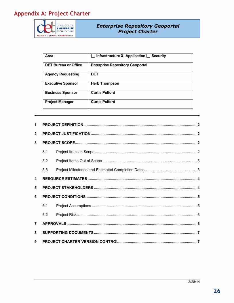
Enterprise Repository Geoportal Project Charter
APPENDICES
Area Infrastructure X- Application Security
DET Bureau or Office Enterprise Repository Geoportal
Agency Requesting DET
Executive Sponsor Herb Thompson
Business Sponsor Curtis Pulford
Project Manager Curtis Pulford
1 PROJECT DEFINITION ........................................................................................................... 2
2 PROJECT JUSTIFICATION .................................................................................................... 2
3 PROJECT SCOPE................................................................................................................... 2
3.1 Project Items in Scope ................................................................................................ 2
3.2 Project Items Out of Scope ......................................................................................... 3
3.3 Project Milestones and Estimated Completion Dates ................................................. 3
4 RESOURCE ESTIMATES ....................................................................................................... 4
5 PROJECT STAKEHOLDERS ................................................................................................. 4
6 PROJECT CONDITIONS ........................................................................................................ 5
6.1 Project Assumptions ................................................................................................... 5
6.2 Project Risks ............................................................................................................... 6
7 APPROVALS ........................................................................................................................... 6
8 SUPPORTING DOCUMENTS ................................................................................................. 7
9 PROJECT CHARTER VERSION CONTROL ......................................................................... 7
Appendix A: Project Charter
Confidential Page 2/28/14
26

Enterprise Repository Geoportal Project Charter
PROJECT DEFINITION
This project will investigate product solutions for enterprise repository and geoportal services. Specifically it will examine how several products meet user needs regarding information resource discoveries, standardization, storage, and access to data. The project will examine and implement a proof of concept(s) for harvesting metadata and securely sharing spatial data and files between state and partner agencies. The result will be a proposal to implement a managed solution for use by state and partner agencies.
PROJECT JUSTIFICATION
Current work on Act 20 initiatives related to geospatial data has prompted stakeholder groups to discuss strategy for geospatial data layer management. Four areas where a DET repository has been cited as solution are: Serving layers without formally recognized ownership (soils, imagery, civil divisions, etc.); A location for aggregation of municipal layers (parcels, zoning, addressing, etc.); Servicing agencies that have spatial data, but do not have GIS server capabilities, and; Reducing redundant storage of all common framework themes. Discussions with the State Agency Geographic Information Council (SAGIC), County Land Information Officers, and several other large stakeholder groups across the state have documented a need for DOA to assume responsibility for the enterprise delivery of repository and geoportal services. These services would discover, inventory, catalog, and provide access to all authoritative spatial data assets managed by Wisconsin government agencies.
PROJECT SCOPE
Project Items in Scope
• Defining business requirements o For repository functions o For geoportal functions
• Defining needed standards o Related to business requirements o Related to governance model o Related to data/metadata
• Investigating open source geoportal products o Esri - geoportal Server o Open Source Geospatial Foundation - GeoNetwork
• Investigating COTS geoportal products o Esri – ArcGIS Portal Appliance o VoyagerSearch – Voyager Server
• Piloting one or more geoportal products • Develop recommendation for:
o (existing) repository upgrade needs
Confidential Page 2/28/14
27

Enterprise Repository Geoportal Project Charter
o Geoportal product implementation o Governance model and standards developments o Resource requirements
Project Items Out of Scope
• Mandated government to government data sharing agreements • Aggregation of municipal datasets into Repository • Map authoring tools • Map services from data • Data services from maps
Project Milestones and Estimated Completion Dates
Project Milestone
Date Estimate Deliverable(s) Included Confidence Level
Establish Stakeholder Team
2 weeks after start
Meeting schedule, Roles and responsibilities
High
Stakeholder Business Requirements
4 weeks after team building
Documentation prioritizing requirements for data repository and geoportal
Medium
Data / Metadata Standards
4 weeks after requirements
Standards recommendations for input/export
Medium
Evaluate products re: requirements
3 weeks after req’s and standards
Report documenting pros and cons based on product literature and support
Low
Product Proof of Concept(s)
6 weeks (1 wk. build, 2 wk test, for ea.)
Evaluation reporting on test products
Low
Final Report 5 weeks Recommendation outlining repository upgrade, geoportal implementation, maintenance and governance needs
Low
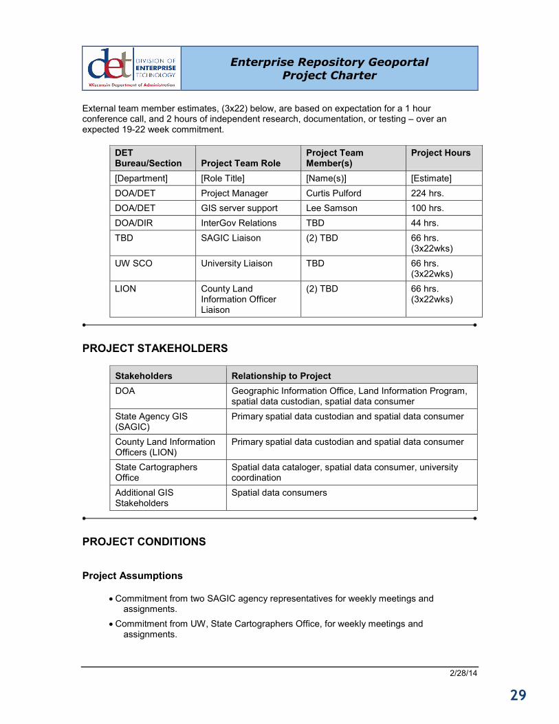
RESOURCE ESTIMATES
Resources within DOA will handle logistics, documentation, website and other communications. The entire Project Team will work together largely through GoToMeeting Web conference calls.
Confidential Page 2/28/14
28
Enterprise Repository Geoportal Project Charter
External team member estimates, (3x22) below, are based on expectation for a 1 hour conference call, and 2 hours of independent research, documentation, or testing – over an expected 19-22 week commitment.
DET Bureau/Section Project Team Role
Project Team Member(s)
Project Hours
[Department] [Role Title] [Name(s)] [Estimate] DOA/DET Project Manager Curtis Pulford 224 hrs. DOA/DET GIS server support Lee Samson 100 hrs. DOA/DIR InterGov Relations TBD 44 hrs. TBD SAGIC Liaison (2) TBD 66 hrs.
(3x22wks) UW SCO University Liaison TBD 66 hrs.
(3x22wks) LION County Land
Information Officer Liaison
(2) TBD 66 hrs. (3x22wks)
PROJECT STAKEHOLDERS
Stakeholders Relationship to Project DOA Geographic Information Office, Land Information Program,
spatial data custodian, spatial data consumer State Agency GIS (SAGIC)
Primary spatial data custodian and spatial data consumer
County Land Information Officers (LION)
Primary spatial data custodian and spatial data consumer
State Cartographers Office
Spatial data cataloger, spatial data consumer, university coordination
Additional GIS Stakeholders
Spatial data consumers
PROJECT CONDITIONS
Project Assumptions
• Commitment from two SAGIC agency representatives for weekly meetings and assignments.
• Commitment from UW, State Cartographers Office, for weekly meetings and assignments.
Confidential Page 2/28/14
29
Enterprise Repository Geoportal Project Charter
• Commitment from two county Land Information Officer representatives for weekly
meetings and assignments.
Project Risks
# Risk Area Likelihood Risk Owner Project Impact-Mitigation Plan 1 Multi-
partner scheduling conflicts
High Project Manager
The project will begin with an understanding that meeting times are fixed. Missed opportunities will affect liaison stakeholder communications, but will not delay the project completion
2 Product availability for proof of concept
Low Project Team Four products are currently viable for evaluation. Should problems arise in acquisition or licensing for test purposes, those products would be eliminated from contention.
APPROVALS
Prepared by Curtis Pulford_______________________ Project Manager
Approved by Herb Thompson (Sponsor) and Senior Leadership Cabinet Executive Sponsor
Curtis Pulford_______________________
Business Sponsor
Confidential Page 2/28/14
30

Enterprise Repository Geoportal Project Charter
SUPPORTING DOCUMENTS
Document Title Document Purpose Link To Document Enterprise Spatial Information ‘Repository / Geoportal’ Investigation
Background, documenting stakeholder needs
PROJECT CHARTER VERSION CONTROL
Version Date Author Change Description
Draft 01/28/2014 Curtis Pulford Draft document created
V.1 02/17/2014 CP Change 1 – Reflecting S.L. comments, entered into PMO system
V.1a 02/28/2014 CP Change 2 – Abridged version created for publication
Confidential Page 2/28/14
31

Appendix B: GeoNetwork Geoportal Evaluation Checklist
Item Description Priority Ability To Meet Requirement Comments On Ability
1 Download data 1.Critical 1-Fully Meets 2 Interoperability (geoportal to access
a repository) 1.Critical 1-Fully Meets
3 Maintainability 1.Critical 2-Partially Meets Little sponsorship, not sure on longevity
4 Price 1.Critical 1-Fully Meets 5 Search capabilities 1.Critical 1-Fully Meets 6 Browse lists / categories 1.Critical 1-Fully Meets 7 Maintenance automations 2.Very Important 3-Capable Doesn't seem to have a clear and
visible path to automation 10 Accessibility / Availability 2.Very Important 1-Fully Meets 12 Efficiency (resource consumption for
given load) 2.Very Important
13 Performance / Response 2.Very Important 1-Fully Meets 15 Preview (map) service 2.Very Important 1-Fully Meets Very nice and easy 16 Secured Endpoint 2.Very Important 2-Partially Meets One by one / Layers 17 Documentation 4.Slightly
Important 2-Partially Meets Fair
18 Wisconsin GIS library (Providing all relevant resources through a single, maintained source)
4.Slightly Important
4-Additions Necessary
Not really designed for this.
20 Reporting 4.Slightly Important
2-Partially Meets Some. Those seen are very good.
32

Appendix C: CKAN Geoportal Evaluation Checklist
Item Description Priority Ability To Meet Requirement Comments On Ability
1 Download data 1.Critical 1-Fully Meets 2 Interoperability (geoportal to access
a repository) 1.Critical 1-Fully Meets
3 Maintainability 1.Critical 3-Capable No sponsorship - Developers go elsewhere?
4 Price 1.Critical 1-Fully Meets 5 Search capabilities 1.Critical 1-Fully Meets 6 Browse lists / categories 1.Critical 1-Fully Meets 7 Maintenance automations 2.Very Important 2-Partially Meets Excellent harvesting. Potential to
automate individual submissions/updates
10 Accessibility / Availability 2.Very Important 1-Fully Meets 12 Efficiency (resource consumption for
given load) 2.Very Important
13 Performance / Response 2.Very Important 1-Fully Meets 15 Preview (map) service 2.Very Important 2-Partially Meets Not intuitive. Seen elsewhere with
custom development 16 Secured Endpoint 2.Very Important 1-Fully Meets Very good 17 Documentation 4.Slightly
Important 2-Partially Meets Fair
18 Wisconsin GIS library (Providing all relevant resources through a single, maintained source)
4.Slightly Important
4-Additions Necessary
Not really designed for this type of thing.
20 Reporting 4.Slightly Important
1-Fully Meets Excellent
33

Appendix D: Voyager Search Geoportal Evaluation Checklist
Item Description Priority Ability To Meet Requirement Comments On Ability
1 Download data 1.Critical 1-Fully Meets 2 Interoperability (geoportal to access
a repository) 1.Critical 1-Fully Meets
3 Maintainability 1.Critical 2-Partially Meets 4 Price 1.Critical 4-Additions
Necessary 100K, plus 20 K maintenance, 10K for individual add-ons.
5 Search capabilities 1.Critical 3-Capable 6 Browse lists / categories 1.Critical 1-Fully Meets 7 Maintenance automations 2.Very Important 3-Capable
10 Accessibility / Availability 2.Very Important 1-Fully Meets 12 Efficiency (resource consumption for
given load) 2.Very Important
13 Performance / Response 2.Very Important 1-Fully Meets 15 Preview (map) service 2.Very Important 4-Additions
Necessary
16 Secured Endpoint 2.Very Important 3-Capable 17 Documentation 4.Slightly
Important 4-Additions Necessary
18 Wisconsin GIS library (Providing all relevant resources through a single, maintained source)
4.Slightly Important
1-Fully Meets
20 Reporting 4.Slightly Important
3-Capable
34

Appendix E: Esri ArcGIS Online Geoportal Evaluation Checklist
Item Description Priority Ability To Meet Requirement Comments On Ability
1 Download data
1.Critical
4-Additions Necessary
2 Interoperability (geoportal to access a repository)
1.Critical 4-Additions Necessary
3 Maintainability 1.Critical 1-Fully Meets 4 Price 1.Critical 5 Search capabilities 1.Critical 1-Fully Meets 6 Browse lists / categories 1.Critical 1-Fully Meets 7 Maintenance automations 2.Very Important 2-Partially Meets
10 Accessibility / Availability 2.Very Important 1-Fully Meets 12 Efficiency (resource consumption for
given load) 2.Very Important
13 Performance / Response 2.Very Important 1-Fully Meets 15 Preview (map) service 2.Very Important 1-Fully Meets 16 Secured Endpoint 2.Very Important 1-Fully Meets 17 Documentation 4.Slightly
Important 2-Partially Meets
18 Wisconsin GIS library (Providing all relevant resources through a single, maintained source)
4.Slightly Important
4-Additions Necessary
20 Reporting 4.Slightly Important
4-Additions Necessary
35

Appendix F: Esri Geoportal Server Evaluation Checklist Item Description Priority Ability To Meet
Requirement Comments On Ability
1 Download data 1.Critical 1-Fully Meets 2 Interoperability (geoportal to
access a repository) 1.Critical 1-Fully Meets
3 Maintainability 1.Critical 2-Partially Meets
No ESRI announcements on long term plans
4 Price 1.Critical 1-Fully Meets 5 Search capabilities 1.Critical 1-Fully Meets Thesaurus service is an available add
on in GitHub 6 Browse lists / categories 1.Critical 1-Fully Meets 7 Maintenance automations 2.Very Important 2-Partially
Meets
10 Accessibility / Availability 2.Very Important 1-Fully Meets 12 Efficiency (resource
consumption for given load) 2.Very Important
13 Performance / Response 2.Very Important 1-Fully Meets 15 Preview (map) service 2.Very Important 2-Partially
Meets Requires a plug in (flash or JavaScript)
16 Secured Endpoint 2.Very Important 2-Partially Meets
requires customization
17 Documentation 4.Slightly Important
2-Partially Meets
Documentation and other requirements are, in some cases, specific to the version
18 Wisconsin GIS library (Providing all relevant resources through a single, maintained, source)
4.Slightly Important
1-Fully Meets
20 Reporting 4.Slightly Important
3-Capable Will need some customization
36

REPOSITORY SECTIO
NS OF R
EPORT
DELETED *P
RIOR TO* P
UBLICATIO
N
2014_0919 DRAFT
Repository Sections of
GIS Enterprise Project: Geoportal Software Recommendations
*Save this document for future repository project reference

REPOSITORY SECTIO
NS OF R
EPORT
DELETED *P
RIOR TO* P
UBLICATIO
N
CONTENTS
REPOSITORY PROJECT ........................... 3 WISCONSIN SPATIAL DATA REPOSITORY BACKGROUND ................................................................. 3 REPOSITORY PROJECT EXECUTION ................................................................................................... 3
Requirements Phase ..................................................................................................................... 3 Product Evaluation Phase ............................................................................................................ 3

REPOSITORY SECTIO
NS OF R
EPORT
DELETED *P
RIOR TO* P
UBLICATIO
N
3
Repository Project
WISCONSIN SPATIAL DATA REPOSITORY BACKGROUND The history of DOA work on a GIS repository dates back to . . . . __ __ __ __ __
REPOSITORY PROJECT EXECUTION
Requirements Phase The project team did not define repository business use cases, thus, this area is left to future projects. However, the team evaluated the current Wisconsin Spatial Data Repositiory with a few basic processes related to use of a repository, including:
Data acquisition • Data preparation, data integration, map service creation, and metadata preparation • Data publication • Data acquisition by users (download) •
Repository System Components Based on the previous work planning for a repository at DOA, it was determined that there are a mimimum of eight components to a Repository, as depicted in Figure 2. Product Evaluation Phase The project team did evaluate one “product”—the current Wisconsin Spatial Data Repository. However, as noted in the background section above, it should be clear that repository services are not currently in use by state agencies or other customers.
Figure 1. Repository system components

REPOSITORY SECTIO
NS OF R
EPORT
DELETED *P
RIOR TO* P
UBLICATIO
N
4
Current Repository Charateristics Some of the repository components are already in place at DOA, although they are not commonly used and have not been used for several years. Figure 3 shows the repository components DOA has yet to acquire, in white boxes.
Current characteristics were summarized according to nine categories, listed here and show in the table on the following page.
Capacity (Initial) 1. Capacity (Limits) 2. Who can store items 3. Who can retrieve items 4. Security system 5. Major uses 6. Notes 7. Pros 8. Cons 9.
Figure 2. Repository components NOT in place at DOA, shown in white boxes

REPOSITORY SECTIO
NS OF R
EPORT
DELETED *P
RIOR TO* P
UBLICATIO
N
5
Wisconsin Spatial Data Repository – Current Characteristics
Repository System
1. Capacity (Initial) 2. Capacity (Limits)
3. Who Can Store Items
GIO - Enterprise FTP 5-10 Gb GIO
GIS Shared Environment Database 2-5Gb GIS Shared Environment Share Owner
GIS Shared Environment File System 2-5Gb GIS Shared Environment Share Owner
GIO SharePoint 2-5Gb Particular Account
Enterprise FTP 5-10 Gb Account Owner
Box (Box.com) ? ? Anyone
4. Who Can Retrieve Items
5. Security System
6. Major Uses
GIO - Enterprise FTP Anyone, Particular FTP User
IAMS Data Transfer
GIS Shared Environment Database Anyone, Particular Account
IAMS Web Services
GIS Shared Environment File System Anyone, Particular Account
IAMS Web Services
GIO SharePoint Particular Account IAMS, WIEXT Document Storage, Data Transfer (under 50 Mb)
Enterprise FTP Anyone, Particular FTP User
IAMS Data Transfer
Box (Box.com) Anyone, Particular User Data Transfer
7. Notes 8. Pros 9. Cons
GIO - Enterprise FTP State System
GIS Shared Environment Database ArcSDE, Oracle Structured Storage Only available to Shared Environment Users
GIS Shared Environment File System Good for Imagery, Cached Files
GIO SharePoint Default file size limit: 50 MB
Enterprise FTP $14/Month per Account State System Expensive
Box (Box.com)

REPOSITORY SECTIO
NS OF R
EPORT
DELETED *P
RIOR TO* P
UBLICATIO
N
6
Repository Evaluation Checklist –(page 1 of 2)
Description Requirement Comments Priority Ability To Meet Requirement
Maintainability Technology sunsets, and staff availability 1.Critical 3 - Capable
Download data 1.Critical 2 - Partially Meets
Price 1.Critical 2 - Partially Meets
Interoperability (geoportal to access a repository)
Repositories must be known and discoverable. Portal returns findings from enterprise or federatated repositories.
1.Critical 1 - Fully Meets
File capacity How much space is needed, do we have enough? 1.Critical 1 - Fully Meets
Performance/ response
2.Very Important 4 - Additions Necessary
Backup and recovery data
2.Very Important 2 - Partially Meets
Maintenance automations
2.Very Important 2 - Partially Meets
Accessibility (and controls)
Evaluation of the process that authorized users access secured folders (tools available, accounts needed, etc.)
2.Very Important 2 - Partially Meets
Efficiency (resource consumption for given load)
2.Very Important 2 - Partially Meets
Output monitoring What files are popular, what number of users, where from. This should be for both.
2.Very Important 2 - Partially Meets
Backup and recovery System
2.Very Important 1 - Fully Meets
Specific seach/browse
For Repository this is authorized access directly to repository services/folders. (e.g., access to local data created with WLIP funding). If it cannot be downloaded from the custodians website/repository, it should be accessible here.
2.Very Important 1 - Fully Meets
Reliability 2.Very Important Important 1 - Fully Meets
Input monitoring How/what data moves to the repository 3. Important 3 - Capable Handle common Data Exchange protocols
3. Important
1 - Fully Meets Documentation 4. Slightly Important 3 - Capable

REPOSITORY SECTIO
NS OF R
EPORT
DELETED *P
RIOR TO* P
UBLICATIO
N
7
Description Status Comments/Suggestions Operational Needs
Ability To Meet Requirement
Maintainability No platforms have sunset issues. Resourcing (human) may not be adequate
Staffing likely needed
Download data FTP Admins will have to ensure 5-10K user access to multi-Gb datasets. DET also needs to provide long (vs. short) term storage for these data
Long term storage (outside of Oracle SDE) needs to be in place via BOX or FTP. Expected large user demand needs to be accomodated.
Price Currently, no expected charge for vector datasets. How tiled map services, and large volume raster datasets are handled is not explicit.
DET must determine if any data storage thresholds exist, and define a solution path (cost or otherwise) when those thresholds are crossed.
Interoperability (geoportal to access a repository)
this is a geoportal issue, our repository will be open to other geoportals
File capacity Currently capable, no exapansion limits
Performance/ response
Clustering of servers (up RAM, CPU, and out Dual servers) will be needed for optimal performance/response
In conjunction with (efficiency) additional product server may be needed for optimal performance. Dedicated (geo) FTP might be a more cost effective, mid-term solution
Backup and recovery data
Data backup exists on Oracle/SDE. No FTP or Cloud data archives are currently in place
Investigate internal and cloud archival
Procedures for archive are not developed (seperate project?)
Maintenance automations
FME is available for manual edits/input. FME Server may be required for large automations
When needed, FME Server should be acquired
Manual update procedures require staff committment, automation reduces staff time but incurs technical costs
Accessibility (and controls)
Accounts domain for secured FTP, Sharepoint,, and Box are available (each having particular caveats)
Users and DET will need to determine, document, and utilize organization and data layer specific guidelines for accessibility through the Repository
Efficiency (resource consumption for given load)
Cannot guarantee 24/7 without redundant servers at additional cost. Architecture will support current planned map services, but config changes may be needed for a much larger service offerring.
In conjunction with (performance/response) server service will be most efficient within a clustered architecture
Output monitoring Will have to work with FTP administrators on reporting from that source
Determine methodology
Backup and recovery System
System recovery is built into enterprise services
Specific seach/browse
Usage agreements need consideration
Reliability Up time history is excellent.
Input monitoring Automations and services for monitoring are possible, though not currently in plans
Determine methodology
Handle common Data Exchange protocols
Documentation Many Repository components are documented by GIO. DET Bureaus responsible for FTP, Sharepoint, and BOX will need to provide documentation.

REPOSITORY SECTIO
NS OF R
EPORT
DELETED *P
RIOR TO* P
UBLICATIO
N
8
Repository Service Estimates The current enterprise Wisconsin spatial data repository service created in 2009 is a loosely defined service. Documentation and workflows for this service have not been updated in the last two to three years. If the repository service is going to be a key part in this new geoportal and repository system, substantial work will be required to redefine and reconfigure the service. This includes doing work to investigate whether private or public cloud storage could play a role in the repository.
Wisconsin Spatial Data Repository
Initial Staff Time1 – Repository redefinition and reconfiguration
Staff Time ($80/hour) Estimate 40 to 80 hours work
$320.00 to $640.00
Ongoing (per month) Technical Costs
Private or Public Cloud Storage Services2 $35.00
2 x FTP Server Accounts $28.00
GIS Shared Environment $360.00
Disk Space ( 300 Gb) $147.00
Staff Time3 ($80/hour) Average of 0.5 hours / week
$160.00
Total Ongoing $730.00
Repository Funding Model The current plan is that this repository service will be free for both users and contributors. DOA’s Division of Enterprise Technology (DET) will pay for the initial development, operations and maintenance of this system. Additional work on this funding model will be part of the implementation plan development project.
1 Initial staff time does not include all the documentation and customization that may be needed 2 Based on Enterprise Box Cloud Storage account: https://www.box.com/pricing/ 3 Ongoing staff time only includes operation and maintenance time—not customization or technical assistance time