gis / geospatial technician workforce competencies · gis / geospatial technician workforce...
TRANSCRIPT

GIS / Geospatial Technician Workforce Competencies
John Johnson, National GeoTech Center
March, 2011
National Geospatial Technology Center of Excellence - Funded in part by the National
Science Foundation DUE ATE #0801893
1

Table of Contents
Part 1: Workforce Technical Competencies Table 1: GIS Technician Task Competencies – Tier 7 (Summary): Ranked by Consensus among DACUM Panels and Complexity…………….. 3 Table 2: GIS Technician Task Competencies – Tier 7 (Detail): Ranked by Consensus among DACUM Panels and Complexity…………….. 5 Part 2: Workforce Knowledge, Skill & Behavior Competencies Table 3: GIS Technician Priority Knowledge & Skill Competencies – Tier 6 (Summary): Ranked by Consensus among DACUM Panels and Complexity……………..16 Table 4: GIS Technician Priority Behavior Competencies (Summary): Ranked by Consensus among DACUM Panels and Complexity……………..17 Table 5: GIS Technician Priority Knowledge & Skill Competencies – Tier 6 (Detail): Ranked by Consensus among DACUM Panels and Complexity……………..18 Table 6: GIS Technician Priority Behavior Competencies (Detail): Ranked by Consensus among DACUM Panels and Complexity……………..23
2

Table 1
GIS Technician Task Competencies - Tier 7 (Summary) Ranked by Consensus among DACUM Panels and Complexity
Aggregate Validation Survey (median)
# Task Categories
DACUM Panels
Related Tasks
Importance # Learning Difficulty #
1 Design & create maps (G1) 8 34 medium 846 medium 785 2 Develop/document procedures (F4) 8 13 medium 296 medium 265 3 Conduct geoprocessing (D1) 7 26 medium 1,298 medium 1,156 4 Acquire data (C1) 7 20 medium 471 medium 426 5 Create/update data (C6) 7 16 high 1,112 medium 1,018 6 Validate data (C3) 7 14 high 571 medium 502 7 Collect field data electronically (B2) 7 12 high 594 medium 534 8 Create reports (G2) 7 9 medium 525 medium 482 9 Convert data (C9) 7 8 high 356 medium 317
10 Organize data (C2) 6 15 medium 824 medium 734 11 Maintain equipment & supplies (F8) 6 15 medium 727 low 624 12 Import/Export data (C5) 6 12 medium 344 medium 303 13 Participate in conferences/workshops (H2) 6 12 medium 691 low 628 14 Create/update metadata (C7) 6 11 high 510 medium 448 15 Provide training (H3) 6 11 medium 434 medium 396 16 Develop & make presentations (G4) 6 10 medium 434 medium 370 17 Evaluate data (A6) 6 9 high 272 medium 252 18 Evaluate data sources (A7) 6 6 high 318 medium 293 19 Coordinate project activities (F1) 5 14 high 62 high 60 20 Disseminate products (G5) 5 14 medium 306 medium 277 21 Georeference data (C8) 5 10 high 773 medium 703 22 Communicate with others (H1) 5 10 high 321 low 290 23 Define data requirements (A1) 5 9 medium 213 medium 194 24 Back-up/restore data (C4) 5 7 medium 351 low 311 25 Attend training (H5) 5 7 medium 484 low 437 26 Conduct geostatistical analysis (D5) 5 6 medium 218 medium 196 27 Develop project timeline/schedule (F6) 5 6 medium 173 medium 158 28 Review job related information (H9) 5 6 medium 262 medium 238
3

Table 1 (cont.) GIS Technician Task Competencies – Tier 7 (Summary) Ranked by Consensus among DACUM Panels and Complexity
Aggregate Validation Survey (median)
# Task Categories
DACUM Panels
Related Tasks Importance # Learning
Difficulty #
29 Develop software applications (E2) 4 13 medium 246 high 225 30 Design/edit databases (E1) 4 9 high 45 high 44 31 Maintain software (E5) 4 8 high 38 medium 36 32 Perform queries (D2) 4 6 33 Digitize data (B4) 4 5 high 331 low 301 34 Geocode data (B5) 4 5 high 380 medium 333 35 Define software/hardware requirements (E3) 4 5 medium 30 medium 28 36 Promote / represent GIS (H7) 4 5 medium 151 medium 145 37 Provide technical support (H8) 4 4 medium 129 medium 118 38 Prepare/assess cost estimates (F5) 3 7 medium 29 medium 29 39 Identify client needs/deliverables (F7) 3 7 40 Conduct network analysis (D3) 3 6 medium 740 medium 631 41 Create tables & charts (G3) 3 6 medium 210 medium 192 42 Optimize database performance (E4) 3 5 medium 281 medium 240 43 Develop user guides (H4) 3 5 medium 58 high 55 44 Define feature behavior (A3) 3 4 medium 162 high 144 45 Conduct image analysis (D4) 3 4 medium 29 high 28 46 Develop data maintenance schedule (A4) 3 3 high 30 medium 28 47 COGO legal descriptions (B1) 3 3 medium 254 medium 227 48 Scan non-digital data (B6) 3 3 medium 305 low 277 49 Supervise interns (H10) 3 3 medium 112 medium 97 50 Determine project scope (F2) 3 3 low 173 medium 157 51 Determine resource requirements (F3) 2 4 52 Join & relate data (A2) 2 3 high 436 medium 397 53 Establish data custodianships (A5) 2 3 medium 47 medium 45 54 Collect field data manually (B3) 2 3 medium 335 low 284 55 Acquire professional certification (H6) 2 2 medium 256 medium 225
Task ranking is by number of DACUM panels followed by aggregate number of related tasks. Task categories are not mutually exclusive. Some categories may also be part of another more general category.
National Geospatial Technology Center, 2010
4

Table 2
GIS Technician Task Competencies - Tier 7 (Detail)
Ranked by Consensus among DACUM Panels and Complexity
Aggregate Validation Survey (median)
Competency
DACUM Panels
Related Tasks
Importance # Learning Difficulty
#
1. Design & create maps (G1) 8 34 medium 846 medium 785
1. Acknowledge contributors 2. Acknowledge contributors and copyrights 3. Adhere to purpose and use of maps 4. Apply cartographic conventions 5. Calculate scale transformations. 6. Conceptualize scale. 7. Create graphic items (e.g. logos, headers, posters, exhibits) (E,C) 8. Create interactive maps (82%) (Adv.) 9. Create map series templates 10. Create map templates (C ) 11. Create Maps 12. Create maps (E,C) 13. Create reference maps (e.g. streets) 14. Create static maps 15. Create thematic maps (e.g. zoning) 16. Define purpose and use of maps 17. Design Cartographic Elements 18. Design layout 19. Design layout 20. Design map layouts 21. Design Maps 22. Determine appropriate fonts and colors 23. Determine appropriate scale 24. Determine appropriate scale and projection 25. Determine appropriate symbology 26. Interpret maps. 27. Make project maps 28. Perform Graphic Design 29. Plot Map 30. Recognize cartographic conventions 31. Resolve spatial conflicts. 32. Select proper media/output device 33. Select proper media/output device 34. Use appropriate symbology.
2. Develop/document procedures (F4) 8 13 medium 296 medium 265
1. Assess documentation needs 2. Complete Company documentation 3. Conform to policies and standards 4. Create documentation 5. Develop GIS procedures (e.g. to update data) 6. Develop policy for sharing data 7. Develop procedural guides 8. Document operating procedures 9. Document Project Results 10. Document what you have done for next person. 11. Establish project standards (e.g. layout & format consistency) 12. Maintain project documentation 13. Produce in-house standardized data documentation.
5

Aggregate Validation Survey (median)
Competency
DACUM Panels
Related Tasks
Importance # Learning Difficulty
#
3. Conduct geoprocessing (D1) 7 26 medium 1,298 medium 1,156
1. Assess output to determine if output is good. 2. Automate Manual Processes (e.g. scripting, modal building) 3. Calculate defined yield 4. Combine data layers 5. Compare data layers 6. Conduct Geoprocessing (e.g. clip, buffering, overlay, run models) (C ) 7. Conduct slope analysis 8. Create Models (e.g. process & scientific models, flow charts) (C ) 9. Create recommendation equations 10. Derive new data (e.g. generate contours from DEM, data generalization) 11. Geoprocess data (e.g. clip, buffer, union) 12. Identify service area 13. Interpolate defined yield 14. Interpolate point data 15. Interpret Results (C ) 16. Interpret topography (i.e., contour lines). 17. Observe data anomalies 18. Perform buffer analysis 19. Perform overlay analysis. 20. Perform proximity analysis 21. Perform site selection 22. Perform vector/raster overlay analysis 23. Perform view shed analysis 24. Pre-process Data (e.g. generalize, subset) (C ) 25. QA/QC Data (C ) (Spatial/Non-Spatial Analysis) 26. Report data anomalies
4. Acquire data (C1) 7 20 medium 471 medium 426
1. Acquire Data 2. Acquire data from originator 3. Acquire existing data (e.g. digital, hard copy) 4. Acquire existing geospatial data 5. Adhere to P&P for sharing and receiving data 6. Adhere to policies for sharing and receiving data 7. Assist in determining data needs/format 8. Contact data originator for acquisition 9. Coordinate data collection 10. Define data collection methods (e.g. GPS, air photo) 11. Gather data for updates 12. Gather data for updates 13. Obtain agronomic data (e.g. soil test, yield) 14. Obtain area of interest boundary data 15. Obtain base map data (e.g. roads, streams, political boundaries, cities) 16. Obtain climate data (e.g. precipitation, wind, temperature) 17. Obtain imagery data (e.g. satellite, aerial) 18. Obtain land use data 19. Obtain terrain feature data (e.g. soil type, topography) 20. Purchase new data
6

Aggregate Validation Survey (median)
Competency
DACUM Panels
Related Tasks
Importance # Learning Difficulty
#
5. Create/update data (C6) 7 16 high 1,112 medium 1,018
1. Create features 2. Create subset data 3. Edit attribute data 4. Edit feature geometry 5. Edit GIS data (e.g. add, delete, update) (E,C) 6. Edit spatial data 7. Enter data base information 8. Match location points with attributes 9. Perform spatial and content updates 10. Perform spatial and content updates 11. Populate GIS feature attributes (E,C) 12. Post / reconcile edits (e.g. changes) 13. Refresh/ replace layers (e.g. imagery, thematic layers) (C ) 14. Update Existing Data 15. Update non-spatial data attributes 16. Update spatial data attributes
6. Validate data (C3) 7 14 high 571 medium 502
1. Finalize data sets 2. Validate agronomic data 3. Validate boundary data 4. Determine data consistencies 5. Verify that updates are error free 6. Ensure Data Quality (Quality Control, Quality Assurance) 7. Conduct Ground Truthing 8. Validate spatial data (e.g. topology, build, verification) 9. Validate tabular data 10. Quality Assurance / Quality Control (Adv.) (Maintain data) 11. Validate data changes (multi-editor environ.) (91%) (Adv.) 12. QA/QC data (E,C) (Maintain GIS Data) 13. Verify content and spatial accuracies 14. Verify accuracy of imported data
7. Collect field data electronically (B2) 7 12 high 594 medium 534
1. Assess current technologies used in data collection. 2. Capture spatial & attribute data 3. Capture spatial and non-spatial data 4. Collect data using GPS 5. Collect field attribute data (E,C) 6. Collect field location data via GPS (E,C) 7. Coordinate geodedic control prior to mapping 8. Electronically collect field spatial data (GPS, Traffic counters, total station, yield monitors) 9. Participate in geodetic control 10. Perform Data Entry (e.g. college GPSdata, collect field data) 11. Post process GPS data (e.g. differential correction) 12. Post-process electronically collected field data (73%) (Adv.)
8. Create reports (G2) 7 9 medium 525 medium 482
1. Create analysis reports (E,C) 2. Create data analysis reports (e.g. tables, charts) 3. Create Database Reports 4. Create project status report 5. Create reports (91%) 6. Generate field reports e.g. budget, input quantities 7. Report Results 8. Report results 9. Write informational reports (e.g. progress, technical, procedural, recommendations) (C )
7

Aggregate Validation Survey (median)
Competency
DACUM Panels
Related Tasks
Importance # Learning Difficulty
#
9. Convert data (C9) 7 8 high 356 medium 317
1. Conversion of digital formats - data abstraction (cut, simplify, stretch & fit) 2. Convert between data formats (C ) 3. Convert data between formats (e.g. KML, XML, RSS) (Adv.) 4. Convert data into consistent formats 5. Convert Data Source (e.g. Auto-CAD) 6. Convert raw data into format of choice 7. Perform data conversions 8. Perform data conversions (between formats) (E, C)
10. Organize data (C2) 6 15 medium 824 medium 734
1. Assist other team members in organizing their work. 2. Categorize data 3. Create directory structure 4. Create naming conventions 5. Establish file structure (Adv.) 6. Make decisions to organize work priorities in light of unexpected contingencies. 7. Normalize data structure (e.g. schema) 8. Organize digital data (e.g. data library) 9. Organize file structure (e.g. create directories, perform data & directory housekeeping (C ) 10. Organize files according to Company procedures 11. Organize files. 12. Organize non-digital data 13. Organize work tasks. 14. Organize written information (i.e., reports, resumes). 15. Perform file management
11. Maintain equipment & supplies (F8) 6 15 medium 727 low 624
1. Comply with company P&P 2. Comply with hardware maintenance agreements 3. Cooperate in using shared equipment 4. Maintain equipment/ supplies) (E,C) 5. Maintain GPS & field equipment (digital camera, laser range finder, DMI) 6. Maintain Hardware 7. Maintain inventory of supplies 8. Maintain plotter / printer 9. Maintain Plotters and Printers 10. Maintain scanner 11. Maintain Vehicle 12. Monitor supplies inventories 13. Order Supplies 14. Request equipment & supplies (e.g. hardware, software) 15. Schedule Equipment
12. Import/Export data (C5) 6 12 medium 344 medium 303
1. Bulk load data and transfer formats. 2. Communicate with other database 3. Connect to external data sources (e.g. odbc, GIS servers) 4. Export application recommendation files 5. Export data in transferable format 6. Export data in transferable format 7. Export data structures 8. Import CAD files (82%) 9. Import data into appropriate formats 10. Import data into existing GIS 11. Import obtained data 12. Integrate data from various sources into consistent format
8

Aggregate Validation Survey (median)
Competency
DACUM Panels
Related Tasks
Importance # Learning Difficulty
#
13. Participate conferences/workshops (H2) 6 12 medium 691 low 628
1. Attend User Conferences 2. Network with industry professionals 3. Network with other job related professionals 4. Participate in GIS user groups (E,C) 5. Participate in job related professional organizations 6. Participate in job related workshops 7. Participate in professional conferences (oral, posters, publish/ submit articles) (E,C) 8. Participate in professional organizations 9. Participate in User Groups 10. Participate in workshops & conferences 11. Present at User Conferences (55%) (Adv.) 12. Visit trade shows
14. Create/update metadata (C7) 6 11 high 510 medium 448
1. Create / update metadata 2. Create and maintain metadata 3. Create and Update Meta Data 4. Create metadata 5. Create metadata 6. Create metadata (E,C) 7. Document spatial and content changes 8. Initiate metadata process 9. Publish metadata 10. Update Metadata 11. Update metadata (E,C)
15. Provide training (H3) 6 11 medium 434 medium 396
1. Assess level of user's knowledge and needs and train accordingly 2. Cross-train within organization (C ) 3. Cross-training (e.g. mentoring, coaching) 4. Establish and maintain remote training sites 5. Organize Staff/Department Training 6. Participate in peer training 7. Provide post training support 8. Provide training 9. Train co-workers 10. Train GIS end-user(s) (C ) 11. Train Other Staff
16. Develop & make presentations (G4) 6 10 medium 434 medium 370
1. Create animation (e.g. 3D, 4D) 2. Create Presentation Materials 3. Create Presentation Materials 4. Create project presentation(s) 5. Develop presentations 6. Give Informational Presentations 7. Present completed products 8. Present project summary 9. Provide information presentations 10. Provide information presentations for users
9

Aggregate Validation Survey (median)
Competency
DACUM Panels
Related Tasks
Importance # Learning Difficulty
#
17. Evaluate data (A6) 6 9 high 272 medium 252
1. Choose data for analysis 2. Determine data compatibility (e.g. projections) (E,C) 3. Evaluate data in context of application. 4. Evaluate data quality. 5. Evaluate spatial data accuracy 6. Handle data types appropriately 7. QA/QC data (E,C) (Create/Acquire GIS Data) 8. Verify accuracy of imported data 9. Verify content and spatial accuracies
18. Evaluate data sources (A7) 6 6 high 318 medium 293
1. Evaluate data sources 2. Evaluate sources 3. Identify data sources/resources 4. Research available data (C ) 5. Research Data Sources 6. Research existing geospatial data
19. Coordinate project activities (F1) 5 14 high 62 high 60
1. Assure QA/QC 2. Conform to policy and standards 3. Coordinate GIS projects (C ) 4. Coordinate multiple activities 5. Coordinate multiple projects and ongoing activities 6. Coordinate Projects with Stakeholders 7. Coordinate with Information Technology (IT) 8. Coordinate with Project Team 9. Coordinate work with Consultants 10. Maintain contracts (E) 11. Make project recommendations 12. Monitor project progress 13. Produce application recommendation files 14. Verify that project goals were met
20. Disseminate products (G5) 5 14 medium 306 medium 277
1. Deliver Maps and Data 2. Disseminate documentation 3. Disseminate documentation where appropriate 4. Disseminate information through a web site 5. Disseminate information via Internet 6. Distribute data according to organizational policy (E,C) 7. Distribute digital products (E,C) 8. Distribute hard copy products (E,C) 9. Load/Burn Data onto Media 10. Manage Web Content 11. Produce deliverables 12. Publish digital spatial information (CD, DVD) 13. Publish Map Products 14. Publish spatial information on-line
10

Aggregate Validation Survey (median)
Competency
DACUM Panels
Related Tasks
Importance # Learning Difficulty
#
21. Georeference data (C8) 5 10 high 773 medium 703
1. Apply appropriate projections 2. Change data’s spatial reference 3. Define data’s spatial reference 4. Georeference data 5. Georeference data 6. Georeference digital imagery (C ) 7. Georeference imagery 8. Rectify images (C ) 9. Rectify raster data (e.g. rubbersheeting) 10. Transform spatial data (e.g. reprojections)
22. Communicate with others (H1) 5 10 high 321 low 290
1. Communicate quality control problems to other team members. 2. Communicate with clients 3. Communicate with co-workers 4. Communicate with peers 5. Communicate with peers 6. Correspond with others (e.g. email, mail, phone) (C ) 7. Inform data users and custodians of update completion 8. Interact with co-workers 9. Let users & data custodians know that updates are completed 10. Present ideas clearly and concisely.
23. Define data requirements (A1) 5 9 medium 213 medium 194
1. Define data requirements (C) 2. Define data requirements (e.g. domains) 3. Determine appropriate projections 4. Determine coverages to be managed 5. Determine data needs / format 6. Determine data to be obtained 7. Determine future uses for completed project data / processes 8. Determine future uses for completed projects/databases 9. Determine resource needs
24. Back-up/restore data (C4) 5 7 medium 351 low 311
1. Archive / retrieve data (E,C) 2. Archive data 3. Backup / restore data (E,C) 4. Back-up Data 5. Back-up finished project files 6. Back-up raw data 7. Implement database backup procedures
25. Attend training (H5) 5 7 medium 484 low 437
1. Attend training 2. Complete job related classes (online / classroom) 3. Conduct self-assessment 4. Evaluate personal performance 5. Maintain technical proficiency 6. Seek additional training 7. Take advanced training courses (e.g. technical training & education courses) (C )
26. Conduct geostatistical analysis (D5) 5 6 medium 218 medium 196
1. Analyze data statistically 2. Apply principles of computational geometry. 3. Generate statistical reports 4. Generate statistics (e.g. descriptive, spatial) (C ) 5. Perform statistical analysis 6. Use random sampling techniques.
11

Aggregate Validation Survey (median)
Competency
DACUM Panels
Related Tasks
Importance # Learning Difficulty
#
27. Develop project timeline/schedule (F6) 5 6 medium 173 medium 158
1. Conform to project timetables 2. Determine project timeline 3. Develop project schedule 4. Develop project timetables 5. Estimate Task Schedule 6. Prioritize Work Load
28. Review job related information (H9) 5 6 medium 262 medium 238
1. Explore new process techniques 2. Read trade publications 3. Research current/emerging trends (e.g. publications, on-line) 4. Research GIS Technology Trends 5. Review industry publications 6. View job related information (e.g. blogs, news feeds, print publications, forums)
29. Develop software applications (E2) 4 13 medium 246 high 225
1. Automate Manual Processes 2. Automate repetitive tasks (Adv.) 3. Create scripts (C ) 4. Customize commercial software (C ) 5. Design application 6. Determine application design format (e.g. platform, language) 7. Determine programming tools required to develop applications 8. Develop application to simplify and/or standardize procedures 9. Develop software applications 10. Enhance existing custom applications 11. Exercise quality control (Application Dev't) 12. QA/QC software applications (e.g. beta test) (C ) 13. Test application performance
30. Design/edit databases (E1) 4 9 high 45 high 44
1. Construct a data base 2. Create data dictionary 3. Create Database Tables 4. Define database fields 5. Define database tables 6. Design Database Structure 7. Determine key fields 8. Develop databases (e.g. define geometry & attributes)(C ) 9. Maintain Data Dictionaries
31. Maintain software (E5) 4 8 high 38 medium 36
1. Comply with software licensing agreements 2. Install Software (e.g. enhancements, service packs) (C ) 3. Install software upgrades 4. Maintain Software 5. Maintain workstation security 6. Recommend software upgrades 7. Support application 8. Update and maintain application
32. Perform queries (D2) 4 6
1. Create Database Queries 2. Perform basic spatial queries 3. Perform data queries. 4. Perform spatial database queries 5. Respond to Geographic Queries 6. Run Database Queries and Calculations
12

Aggregate Validation Survey (median)
Competency
DACUM Panels
Related Tasks
Importance # Learning Difficulty
#
33. Digitize data (B4) 4 5 high 331 low 301
1. "Heads-up" digitize data 2. Digitize feature geometry 3. Perform “heads-up” (on-screen) digitization (E,C) 4. Perform Data Entry (e.g. digitize geographic features, create Auto-Cad) 5. Perform tablet digitization (E,C)
34. Geocode data (B5) 4 5 high 380 medium 333
1. Geocode (Adv) 2. Geocode addresses 3. Geocode data (E, C) 4. Perform Geo-coding 5. Reverse geocode (82%) (Adv)
35. Define software/hardware requirements (E3) 4 5 medium 30 medium 28
1. Define user software needs (C ) 2. Determine hardware /software requirements/ constraints 3. Provide Technology Recommendations 4. Recommend new technologies 5. Select database software (performance, usability, cost, manageability, uses, output format)
36. Promote / represent GIS (H7) 4 5 medium 151 medium 145
1. Educate and Promote GIS Capabilities 2. Participate in public relations activities (E,C) 3. Perform Community outreach 4. Promote GIS uses 5. Represent GIS at meetings (committees, user groups, organizational conferences) (E,C)
37. Provide technical support (H8) 4 4 medium 129 medium 118
1. Provide Technical Support 2. Provide technical support for users (Adv.) 3. Resolve user technical problems (C ) 4. Troubleshoot hardware/software problems
38. Prepare/assess cost estimates (F5) 3 7 medium 29 medium 29
1. Assess acquisition costs 2. Assess maintenance & update cost 3. Assess project costs 4. Budget project 5. Meet project budget 6. Obtain data acquisition cost quotes 7. Prepare cost estimates (e.g. time, equipment) (C )
39. Identify client needs/deliverables (F7) 3 7
1. Assess client need 2. Assess client needs 3. Assist in defining deliverables (maps, reports,…) 4. Define deliverables 5. Determine project needs 6. Gather User Requirements 7. Respond to Public Records Request
40. Conduct network analysis (D3) 3 6 medium 740 medium 631
1. Identify least-cost path 2. Identify shortest route 3. Linear reference data 4. Model linear networks 5. Perform dynamic segmentation (18%) (Adv.) 6. Perform network analysis (dynamic segmentation)
13

Aggregate Validation Survey (median)
Competency
DACUM Panels
Related Tasks
Importance # Learning Difficulty
#
41. Create tables & charts (G3) 3 6 medium 210 medium 192
1. Create charts (82%) 2. Create charts (E,C) 3. Create Database Tables 4. Create Mail Lists 5. Create tables (E,C) 6. Generate mailing labels (E,C)
42. Optimize database performance (E4) 3 5 medium 281 medium 240
1. Conduct database performance tuning (e.g. compress, build stats, index) (C ) 2. Optimize data file folders (Adv.) 3. Optimize data files (Adv.) 4. Optimize database structure (Adv.) 5. Optimize workstation performance
43. Develop user guides (H4) 3 5 medium 58 high 55
1. Build help files 2. Create "read me" files 3. Develop training applications and course materials 4. Develop users guides 5. Write Technical Guides (C )
44. Define feature behavior (A3) 3 4 medium 162 high 144
1. Build topology. 2. Create topology for related features (64%) (Adv.) 3. Define feature behaviors (e.g. sub-types & domains) (C ) 4. Define feature relationships/behaviors (relate tables, relationship classes)
45. Conduct image analysis (D4) 3 4 medium 29 high 28
1. Classify remote sensing data 2. Develop orthophotography 3. Interpret Imagery 4. Perform image analysis (e.g. classification) (C )
46. Develop data maintenance schedule (A4) 3 3 high 30 medium 28
1. Conform to data maintenance schedule 2. Develop a data maintenance schedule 3. Develop data maintenance schedules
47. COGO legal descriptions (B1) 3 3 medium 254 medium 227
1. COGO (55%) 2. COGO legal descriptions (E) 3. Digitize data using COGO (e.g. metes & bounds)
48. Scan non-digital data (B6) 3 3 medium 305 low 277
1. Scan hard copy images (E, C) 2. Scan hard copy maps 3. Scan non-digital data (91%)
49. Supervise interns (H10) 3 3 medium 112 medium 97
1. Participate in Hiring and Supervisory Activities 2. Supervise interns (82%) (Adv.) 3. Supervise Interns (C )
50. Determine project scope (F2) 3 3 low 173 medium 157
1. Determine scope of project 2. Develop Project Plan 3. Develop project scope
51. Determine resource requirements (F3) 2 4
1. Allocate internal / external resource needs (equipment, personnel, data) 2. Determine resource needs (equipment, personnel, data) 3. Maintain project resources 4. Optimize resources
14

Aggregate Validation Survey (median)
Competency
DACUM Panels
Related Tasks
Importance # Learning Difficulty
#
52. Join & relate data (A2) 2 3 high 436 medium 397
1. Join non-spatial data 2. Join tables (e.g. link, join, relate) 3. Perform spatial join
53. Establish data custodianships (A5) 2 3 medium 47 medium 45
1. Assign data/database permissions 2. Establish data custodianship (C) 3. Establish the data custodianships
54. Collect field data manually (B3) 2 3 medium 335 low 284
1. Administer questionnaires (27%) 2. Collect data using field sheets 3. Manually collect attribute data in the field (82%)
55. Acquire professional certification (H6) 2 2 medium 256 medium 225
1. Acquire GIS Certification (45%) 2. Obtain professional certification (e.g. GISP, ASPRS)
Task ranking is by number of DACUM panels followed by aggregate number of related tasks. Task categories are not mutually exclusive. Some categories may also be part of another more general category.
National Geospatial Technology Center, 2010
15

Table 3 GIS Technician: Priority Knowledge & Skill Competencies – Tier 6 (Summary) Ranked by Consensus among DACUM Panels and Complexity
Aggregate Related Validation DACUM Knowledge Survey (median)
# Knowledge & Skill Categories Panels & Skills Importance Responses
1 Communication: verbal/presentation/writing (2) 8 23 medium 753
2 Critical thinking/Problem Solving (10) 7 13 high 318
3 Organizational (24) 7 11 high 343
4 Mathematics (geometry, statistics) (23) 7 9 medium 391
5 Time management (32) 7 7 high 291
6 Cartography (1) 6 8 medium 416
7 Computer programming (7) 6 6 medium 280
8 Computer basics (3) 5 12 medium 311
9 Computer database (4) 5 12 medium 253
10 Land divisions, measurements (20) 5 11 medium 511
11 Photogrammetry/Remote Sensing (25) 5 8 medium 264
12 Computer software (8) 5 7 medium 331
13 Map reading (22) 5 5 high 228
14 Troubleshooting (33) 5 5 high 238
15 Industry applications (18) 4 11 medium 264
16 Data types, transfers & conversions (12) 4 8 high 628
17 Geography (15) 4 7
18 Standards (client, customer, industry) (30) 4 7 medium 594
19 Coordinate systems, projections (9) 4 6 high 235
20 Computer keyboarding (5) 4 4 medium 237
21 Scale (28) 4 4 high 237
22 Geoprocessing, modeling (16) 3 6 medium 512
23 Data models (11) 3 5 high 157
24 Jargon, acronyms (19) 3 4 medium 155
25 Research (27) 3 4 medium 155
26 Computer networks (6) 2 4 medium 52
27 Equipment operation (14) 2 4 medium 155
28 Engineering drawings (13) 2 3 medium 53
29 Spatial Thinking (29) 2 3 high 156
30 Units of measure/conversion (34) 2 3 medium 392
31 GPS (17) 2 2
32 Queries & analysis (26) 2 2 medium 224
33 Web development (35) 1 3
34 Legal issues (21) 1 2 medium 136
35 Teaching (31) 1 1
Categories are not mutually exclusive. Some knowledge, skill and behavior categories may also be part of another more general category. Source: National Geospatial Technology Center, 2010
16
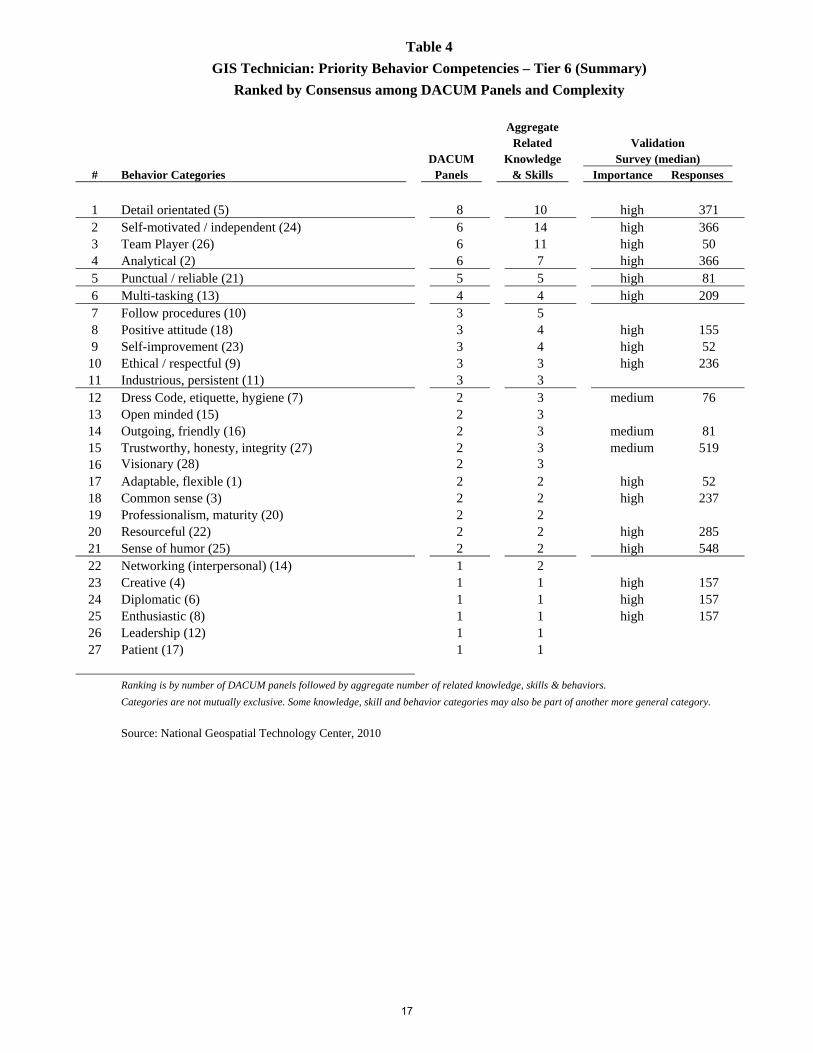
Table 4 GIS Technician: Priority Behavior Competencies – Tier 6 (Summary) Ranked by Consensus among DACUM Panels and Complexity
Aggregate Related Validation DACUM Knowledge Survey (median)
# Behavior Categories Panels & Skills Importance Responses
1 Detail orientated (5) 8 10 high 371 2 Self-motivated / independent (24) 6 14 high 366 3 Team Player (26) 6 11 high 50 4 Analytical (2) 6 7 high 366 5 Punctual / reliable (21) 5 5 high 81 6 Multi-tasking (13) 4 4 high 209 7 Follow procedures (10) 3 5 8 Positive attitude (18) 3 4 high 155 9 Self-improvement (23) 3 4 high 52
10 Ethical / respectful (9) 3 3 high 236 11 Industrious, persistent (11) 3 3 12 Dress Code, etiquette, hygiene (7) 2 3 medium 76 13 Open minded (15) 2 3 14 Outgoing, friendly (16) 2 3 medium 81 15 Trustworthy, honesty, integrity (27) 2 3 medium 519 16 Visionary (28) 2 3 17 Adaptable, flexible (1) 2 2 high 52 18 Common sense (3) 2 2 high 237 19 Professionalism, maturity (20) 2 2 20 Resourceful (22) 2 2 high 285 21 Sense of humor (25) 2 2 high 548 22 Networking (interpersonal) (14) 1 2 23 Creative (4) 1 1 high 157 24 Diplomatic (6) 1 1 high 157 25 Enthusiastic (8) 1 1 high 157 26 Leadership (12) 1 1 27 Patient (17) 1 1
Ranking is by number of DACUM panels followed by aggregate number of related knowledge, skills & behaviors. Categories are not mutually exclusive. Some knowledge, skill and behavior categories may also be part of another more general category.
Source: National Geospatial Technology Center, 2010
17

Table 5
GIS Technician: Priority Knowledge & Skill Competencies – Tier 6 (Detail)
Ranked by Consensus among DACUM Panels and Complexity Aggregate Related Validation DACUM Knowledge Survey (median) Knowledge & Skill Categories Panels & Skills Importance Responses
1. Communication: verbal/presentation/writing (2) 8 23 medium 753 1. Business skills 2. Communication 3. Communication skills 4. Communication skills (verbal & written) 5. Communication skills (writing, reading) 6. Communication skills -oral 7. Communication skills -written, email 8. Demonstrate ability to research information. 9. Demonstrate active listening skills. 10. Demonstrate initiative in communicating ideas. 11. Demonstrate negotiation skills. 12. Demonstrate oral communication skills (individual, group, team, client presentations). 13. Demonstrate technical writing skills. 14. Good written and verbal interpersonal communication skills 15. Graphing & reporting 16. Oral Communication 17. People skills (public relations, communication) 18. Presentation 19. Printing legibly 20. Technical writing 21. Technical writing 22. Verbal & written communication 23. Verbal communication
2. Critical thinking/Problem Solving (10) 7 13 high 318 1. “Think Outside the Box”, "See the big picture" 2. Analytical thinker 3. Break problem into manageable parts. 4. Critical thinking 5. Critical thinking 6. Critical thinking 7. Problem solve 8. Problem solving 9. Problem solving 10. Problem solving skills 11. Problem solving skills 12. Recognize and define problem(s). 13. Solution-orientated
3. Organizational (24) 7 11 high 343 1. Demonstrate ability to maintain focus and be consistent. 2. Demonstrate file management skills. 3. Demonstrate neatness. 4. Interpret and implement procedures methodically. 5. Organization 6. Organizational 7. Organizational 8. Organizational skills 9. Organized 10. Organized 11. Organized
18

Aggregate Related Validation DACUM Knowledge Survey (median) Knowledge & Skill Categories Panels & Skills Importance Responses
4. Mathematics (geometry, statistics) (23) 7 9 medium 391 1. Geometry 2. Mathematics 3. Mathematics 4. Mathematics (geometry, statistics, trigonometry, algebra) 5. Statistics 6. Statistics 7. Statistics 8. Statistics 9. statistics
5. Time management (32) 7 7 high 291 1. Diversified task - time management 2. Time management 3. Time management 4. Time management 5. Time Management 6. Time management skills 7. Time management skills
6. Cartography (1) 6 8 medium 416 1. Cartographic design 2. Cartographic Design 3. Cartographic license 4. Cartographic principles/theory 5. Cartography 6. Create map book 7. Demonstrate graphic design skills. 8. Demonstrate map design and layout.
7. Computer programming (7) 6 6 medium 280 1. Apply basic programming princi-ples (SQL statements, Boolean logic, macros). 2. Basic scripting (SQL, VB, HTML, Python, ASP, CSS, Query) 3. Experience with computer programming concepts 4. Programming 5. programming 6. Programming languages (VBA)
8. Computer basics (3) 5 12 medium 311 1. Apply basic concepts of hardware storage. 2. Burn to disk 3. Computer skills 4. Computer skills (above average) 5. Define and differentiate among computer terms related to networks. 6. Demonstrate knowledge of basic computer concepts and terms. 7. Demonstrate knowledge of graphical user interface environ-ment (i.e., Windows). 8. FTP site 9. Internet skills, esp. data collection and attribution 10. Operating systems 11. Use basic operating system commands. 12. Use Internet, ftp, e mail, computer faxes.
9. Computer database (4) 5 12 medium 253 1. Computer Science-database design 2. Computer Science-information management 3. Digital file management 4. Database development 5. Database administration 6. Experience with relational databases 7. Data custodianship 8. Database structure 9. Data exchange procedures 10. Security restrictions on data 11. Relational database design, 12. file management
19

Aggregate Related Validation DACUM Knowledge Survey (median) Knowledge & Skill Categories Panels & Skills Importance Responses
10. Land divisions, measurements (20) 5 11 medium 511 1. Basic survey principles 2. basics of surveying 3. Cadastral data 4. Coordinate geometry (COGO) 5. Interpret legal descriptions 6. Land measurements 7. Land descriptions 8. Land divisions 9. Land surveying 10. Legal descriptions 11. Plats & deeds
11. Photogrammetry/Remote Sensing (25) 5 8 medium 264 1. Geography-photogrammetry 2. Geography-remote sensing 3. Basic remote sensing theory 4. Photogrammetry 5. Remote sensing 6. Thermal imaging 7. Photogrammetry 8. Remote sensing
12. Computer software (8) 5 7 medium 331 1. Geography-competency in software 2. Legacy technology 3. Modify user interface 4. End user Web applications 5. Use software applications. 6. Use various platforms. 7. GIS software
13. Map reading (22) 5 5 high 228 1. Cadastral 2. Conceptualize images in 3 D. 3. Good color sensitivity helpful 4. Map interpretation 5. Map reading
14. Troubleshooting (33) 5 5 high 238 1. Geography-navigation/trouble shooting 2. Troubleshooting 3. Troubleshooting 4. Troubleshooting 5. Troubleshooting skills
15. Industry applications (18) 4 11 medium 264 1. Demonstrate fundamental drafting skills. 2. Drafting 3. Engineering-survey 4. Explain how GIS can be used in various real world applications. 5. Fisheries 6. Forestry basics/survey 7. Geology 8. Identify applications of GIS technology. 9. Related Industries 10. Variable Rate Technology (VRT) 11. Wildlife
20

Aggregate Related Validation DACUM Knowledge Survey (median) Knowledge & Skill Categories Panels & Skills Importance Responses
16. Data types, transfers & conversions (12) 4 8 high 628 1. Adding data to a project (GIS, CAD) 2. Data collection and format conversion 3. Data manipulation (spatial, non-spatial) 4. Data sources 5. Data transfer 6. Export formats, properties; settings 7. File transfer 8. File types (SHP, GDB, Coverage, CAD, DGN, TXT, IMG, TIF, SID, Flash, PDF, GeoPDF, e00, PkZIP, RAR,
TAR
17. Geography (15) 4 7 1. Apply principles of geography. 2. Geographic principles 3. Geography 4. Geography-Cartography 5. Geography-census 6. Geography-transportation 7. Geography-urban planning
18. Standards (client, customer, industry) (30) 4 7 medium 594 1. “ISO 9000” standards 2. Client/company standards 3. GIS Industry standards 4. Naming conventions 5. Quality control & assurance procedures 6. technological standards 7. Understand national documentation standards
19. Coordinate systems, projections (9) 4 6 high 235 1. Coordinate systems 2. Coordinate systems Projections 3. map datum, geoid 4. projections 5. Recognize projections. 6. Spatial projections
20. Computer keyboarding (5) 4 4 medium 237 1. Data entry 2. Demonstrate keyboarding skills. 3. Keyboarding 4. Typing
21. Scale (28) 4 4 high 237 1. Demonstrate appropriate scale for message.2. Map scale 3. Scale 4. Scale
22. Geoprocessing, modeling (16) 3 6 medium 512 1. Contour mapping 2. Create TIN model 3. Creating models 4. Evaluate a physical model. 5. Explain how a data model works. 6. Geoprocessing methods
23. Data models (11) 3 5 high 157 1. Conceptualize model of reality. 2. Differentiate between raster space and real space. 3. Raster / Vector 4. Raster and vector data 5. Recognize raster and vector models.
21

Aggregate Related Validation DACUM Knowledge Survey (median) Knowledge & Skill Categories Panels & Skills Importance Responses
24. Jargon, acronyms (19) 3 4 medium 155 1. Industry jargon 2. Jargon 3. Platform shop talk 4. Technical terminology
25. Research (27) 3 4 medium 155 1. Demonstrate ability to research information.2. Research technical support 3. Research techniques 4. Scientific methods
26. Computer networks (6) 2 4 medium 52 1. Computer networking 2. Computer, Network configuration 3. Networking systems 4. Windows networks
27. Equipment operation (14) 2 4 medium 155 1. Application equipment capabilities/limitations 2. Plotter operation 3. Technical operating 4. Understanding of equipment interactions
28. Engineering drawings (13) 2 3 medium 53 1. Engineering-CAD 2. Engineering-COGO 3. Reading engineering-grade plans
29. Spatial Thinking (29) 2 3 high 156 1. Demonstrate spatial intelligence. 2. Recognize spatial inconsistencies. 3. Spatial awareness
30. Units of measure/conversion (34) 2 3 medium 392 1. Unit conversions 2. Unit conversions 3. Units of measure
31. GPS (17) 2 2 1. Global GPS system 2. Global Positioning System (GPS)
32. Queries & analysis (26) 2 2 medium 224 1. Interpolation 2. Query (spatial/attribute)
33. Web development (35) 1 3 1. Relevant domain knowledge 2. Web content management 3. Web development
34. Legal issues (21) 1 2 medium 136 1. Copyright laws 2. OSHA requirements
35. Teaching (31) 1 1 1. Teaching skills
Ranking is by number of DACUM panels followed by aggregate number of related knowledge, skills & behaviors.
Categories are not mutually exclusive. Some knowledge, skill and behavior categories may also be part of another more general category.
Source: National Geospatial Technology Center, 2010
22

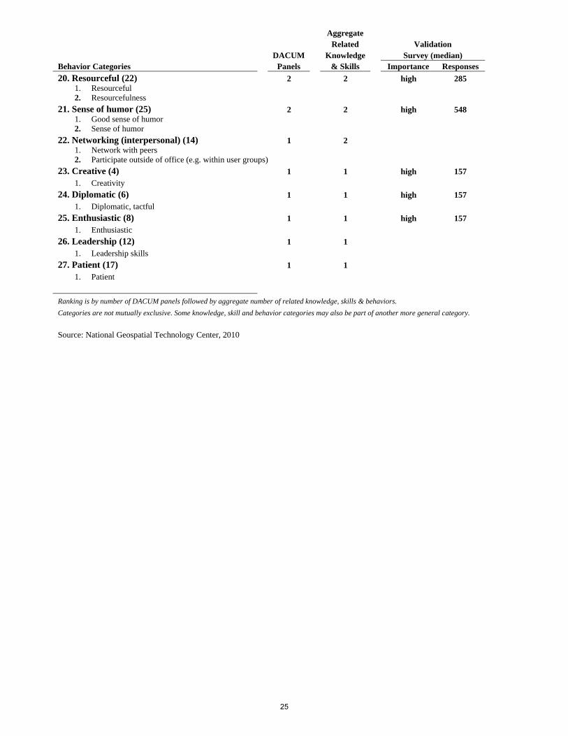
Table 6
GIS Technician: Priority Behavior Competencies (Detail) Ranked by Consensus among DACUM Panels and Complexity
Aggregate Related Validation DACUM Knowledge Survey (median) Behavior Categories Panels & Skills Importance Responses
1. Detail orientated (5) 8 10 high 371 1. Attentive to detail 2. Observant 3. Detail orientated 4. Attention to detail 5. Detail orientated 6. Accuracy & precision 7. Detail oriented 8. Detail-oriented 9. Check work. 10. Thoroughness
2. Self-motivated / independent (24) 6 14 high 366 1. Ability to work independently 2. Can work independently 3. Independent 4. Independent worker 5. Motivated 6. motivated 7. Self motivation 8. Self-disciplined 9. Self-initiated learner 10. Self-motivated 11. Self-motivated 12. Self-starter 13. Self-starter 14. Self-starter, independent worker
3. Team Player (26) 6 11 high 50 1. Can work in team 2. Demonstrate ability to work in a team as a member and/or leader. 3. Interpersonal 4. Networking 5. Recognize roles of others in team and cooperate to get job done. 6. Team building 7. Team participation 8. Team player 9. Team player 10. Team Player 11. Team worker
4. Analytical (2) 6 7 high 366 1. Analytical 2. Analytical 3. Analytical 4. Analytical 5. Analytical, detail oriented 6. Interpret technical information (i.e., manuals and CD Rom) 7. Logical, intelligent
5. Punctual / reliable (21) 5 5 high 81 1. Consistent 2. Punctual 3. Punctuality 4. Punctuality 5. Reliable - punctual
23

Aggregate Related Validation DACUM Knowledge Survey (median) Behavior Categories Panels & Skills Importance Responses
6. Multi-tasking (13) 4 4 high 209 1. Ability to multi-task 2. Able to multi-task, set work priorities 3. Multi-tasking 4. Multi-tasking
7. Follow procedures (10) 3 5 1. follow procedures 2. Recognize the importance of following procedures. 3. Follow technical procedures. 4. Demonstrate data entry and digitizing skills. 5. Understanding of copyright laws and standards
8. Positive attitude (18) 3 4 high 155 1. Attitude 2. Can-do, positive attitude 3. Positive attitude 4. Positive attitude
9. Self-improvement (23) 3 4 high 52 1. Ability to learn 2. Self-improvement 3. Willingness to learn 4. Willingness to learn
10. Ethical / respectful (9) 3 3 high 236 1. Ethical 2. Ethical behavior (integrity) 3. Respectful of others
11. Industrious, persistent (11) 3 3 1. Demonstrate ability to be persistent at collecting data. 2. Industrious 3. Persistence
12. Dress Code, etiquette, hygiene (7) 2 3 medium 76 1. Dress code 2. Hygienic 3. Use appropriate office etiquette
13. Open minded (15) 2 3 1. Open to new tasks, assignments, ideas 2. Open-minded 3. Open-minded
14. Outgoing, friendly (16) 2 3 medium 81 1. Easy-going 2. Outgoing (friendly) 3. People skills
15. Trustworthy, honesty, integrity (27) 2 3 medium 519 1. Honesty 2. Integrity 3. Trustworthy with confidential information
16. Visionary (28) 2 3 1. Abstract thinker (outside the box) 2. Divine - all knowing 3. Visionary
17. Adaptable, flexible (1) 2 2 high 52 1. Adaptability 2. Adaptable, Flexible
18. Common sense (3) 2 2 high 237 1. Common sense 2. Common sense
19. Professionalism, maturity (20) 2 2 1. maturity 2. Professionalism
24
Aggregate Related Validation DACUM Knowledge Survey (median) Behavior Categories Panels & Skills Importance Responses
20. Resourceful (22) 2 2 high 285 1. Resourceful 2. Resourcefulness
21. Sense of humor (25) 2 2 high 548 1. Good sense of humor 2. Sense of humor
22. Networking (interpersonal) (14) 1 2 1. Network with peers 2. Participate outside of office (e.g. within user groups)
23. Creative (4) 1 1 high 157 1. Creativity
24. Diplomatic (6) 1 1 high 157 1. Diplomatic, tactful
25. Enthusiastic (8) 1 1 high 157 1. Enthusiastic
26. Leadership (12) 1 1 1. Leadership skills
27. Patient (17) 1 1 1. Patient
Ranking is by number of DACUM panels followed by aggregate number of related knowledge, skills & behaviors.
Categories are not mutually exclusive. Some knowledge, skill and behavior categories may also be part of another more general category.
Source: National Geospatial Technology Center, 2010
25