gis interactive web-tool austria-2009

1
INTERACTIVE WEB VISUALIZATION TOOLS FOR THE INTERPRETATION OF THE RESULTS OF A SEISMIC RISK STUDY AIMED AT THE DEFINITION OF EMERGENCY LEVELS Results of a seismic risk assessment study are often applied and interpreted by users unspecialized on the topic or lacking a scientific background. In this context, the availability of tools that help translating essentially scientific contents to broader audiences (such as decision makers or civil defense officials) as well as representing and managing results in a user-friendly fashion, are on indubitable value. One of such tools is the visualization tool VISOR-RISNA, a web tool developed within the RISNA project (financed by the Emergency Agency of Navarre, Spain) for regional seismic risk assessment of Navarre and the subsequent development of emergency plans. SUMMARY GIS-RISNA (CONCEPTUAL MODEL) VISOR-RISNA (PARTIAL AND FINAL RESULTS OF THE RISK STUDY) CONTACT: ETSI Topografía, Geodesia y Cartografía, Universidad Politécnica de Madrid, SPAIN [email protected] + 34 913366441 CONCLUSIONS The use of thematic cartography integrated in a web environment to show results of a regional seismic hazards study is a straightforward, useful solution that allows unspecialized users to access large data bases in an easily understandable way. Accordingly, a tool such as VISOR-RISNA is an effective instrument in helping end-users to achieve informed and data constrained decisions for the development of emergency plans. A. Rivas-Medina, V. Gutierrez ,J. M. Gaspar-Escribano, B. Benito ETSI Topografía, Geodesia y Cartografía, Universidad Politécnica de Madrid, Spain TABLE OF VALUES GRID Surface representation PGA SA 0.1 s SA 2 s Geo-statistical analysis AMPLIFICATION FACTORS GEOTECHNICAL CLASSIFICATION Values assignment * = * * * = = = AMPLIFICATION FACTOR SA 0.1 s SOIL SA 2 s SOIL Combination of raster layers INTENSITY Combination of raster layers I = 0.0661 log PGA + 3.247 log EPA + 0.1311 INTENSITY Consulta estadística zonal BUILT SURFACE WORKING UNIT EDIFICES C TOTAL A D B Aggregation of attributes and elements. Assignation of vulnerabilities to working units (according to transfer matrices) DAMAGE MATRICES MEAN SLIGHT MODERATE STRONG A B C D TOTAL UNINHABITABLES Mean damage calculation VULNERABILITY MATRICES The RISNA Geographical Information System is developed within the RISNA Project for the regional seismic risk assessment of Navarre The risk study is divided in six connected modules. M1 Module for seismic hazard on rock conditions. M2 Module for the geotechnical classification, including site amplification factors. M3 Module for seismic hazard including soil conditions. M4 Module for macroseismic intensity related to input ground motion. M5 Module for seismic vulnerability of normal-importance structures. M6 Module for expected seismic damage. The proper accomplishment of the study requires integrating correctly all variables within the same geographical frame. For these goals, GIS tools are very adequate, and constitute the best choice for geographical data analyses and results representation. Figure 1. Static diagram of classes for the project in UML Language. The model is designed in the following way: 1. Colored squares represent the thematic modules of the study 2. The geometry of the classes appears in the upper part of the model and the raster and vector layers in the right and left sides, respectively. 3. Light grey color represent classes corresponding to raster layers. For vector layers, a vertically-graded color pattern is used. Plain colors are used for abstract classes (tables without geographical representation). 4. Numbering and types are located in the lower left corner, with blue and green colors, respectively. DEFINITION OF EMERGENCY LEVELS The parameters considered for the definition of emergency levels, linked to the expected ground motion, are: -Macroseismic intensity for the 475-year return period as ground motion parameter. - Expected mean damage, expected amount of buildings with strong damage number and percentage of building resulting uninhabitable, as damage parameters. - Amount of homeless persons as their homes result uninhabitable, as exposure-plus-damage parameter. Combinations of these parameters allow obtaining a hierarchy of municipalities with different actuation levels related to certain alert levels. Through guided queries, decision makers and Civil Protection officials may establish parameter intervals depending on the available human, material and technical resources. Seismic hazard results on rock conditions (peak ground acceleration (1) and spectral acceleration for different vibration periods in gals). Seismo-geotechnical regionalization of the study region in five soil classes (1) and amplification factors (2). Seismic hazard results including site effects (peak ground acceleration and spectral acceleration for different vibration periods in gals). (1) Figure 2. Analysis of information and processes performed The RISNA study included seismic hazard evaluation, geotechnical characterization of soils, incorporation of site effects to expected ground motions, vulnerability distribution assessment and estimation of expected damage distributions for a 10% probability of exceedance in 50 years. The main goal of RISNA was the identification of higher risk area where focusing detailed, local-scale risk studies in the future and the corresponding urban emergency plans. A geographic information system was used to combine different information layers, generate tables of results and represent maps with partial and final results. The visualization tool VISOR-RISNA is intended to facilitate the interpretation and representation of the collection of results, with the ultimate purpose of defining actuation plans. A number of criteria for defining actuation priorities are proposed in this work. They are based on combinations of risk parameters resulting from the risk study (such as expected ground motion and damage and exposed population), as determined by risk assessment specialists. The combination of those parameters and their distribution on classes (for identifying risk levels) is carried out by decision makers. These criteria provide a ranking of municipalities according to the expected actuation level and eventually, to alert levels. In this regard, the visualization tool constitutes an intuitive and useful tool that the end-user of the risk study may use to optimize and guide its application on emergency planning. The use of this type of tools can be adapted to other scenarios with different boundary conditions (seismicity level, vulnerability distribution) and user profiles (policy makers, stakeholders, students, general public) maintaining the same final goal: to improve the adaptation of the results of a scientific-technical work to the needs of other users with different backgrounds. Taking advantage of the geographical nature of the information and to facilitate the interpretation of partial and final results of the study by end-users, several user-friendly and user-specific products are developed. These include a collection of maps (similar to a thematic atlas) and a web visualiser called VISOR-RISNA, which are intended to aid Civil Protection authorities on the definition of their actuation plans and supporting their decisions. Several categories representative not only for the expected damage, but also for the expected ground motion and the exposed population are combined to make a rank of geographical units. These categories include intervals of relative and absolute parameters values. Example of query which could be used to help defining actuation levels. Highlighted areas satisfy all conditions imposed. ANALYSES AND PROCESSES SIG FEATURES Modular structure of the entire study within the GIS platform M1 M2 M3 M4 M5 M6 1 2 1 1 1 2 3 4 5 Municipal distribution of expected ruined buildings (1), including detailed data for each geographical unit (2) and (3). 1 3 2 Geographical working unit : A combination of Zip code and municipalities. Working scale : OUTCOME SCALE is 1:200.000 for calculations and analyses. The INPUT SCALES differ: The cartographic base of Navarre has a scale 1:100.000, and the geological cartography has a 1:200.000 scale. Reference System : ETRS89 (European Earth Reference System 1989), of official use in Spain. Working tool : ArcGIS v 9.3, which allows making all processes in the same platform: data capture and edition, variables analyses and Web visualiser . Municipal distribution of expected damage for each vulnerability class (1), including relative and absolute estimates (2) and (3), and providing detailed results for each municipality (4) and (5) 1 2 3 4 5 Municipal distribution of seismic vulnerability expressed by the total vulnerability distribution (1), absolute and relative amounts of buildings of each vulnerability class (2) and (3) and detailed data fcor each municipality (4) and (5). ACKNOWLEDGEMENTS: The RISNA Project was financed by the Emergency Agency of Navarre

Upload: vladimir-gutierrez-phd

Post on 10-Aug-2015

49 views

Category:

Travel


0 download

TRANSCRIPT

INTERACTIVE WEB VISUALIZATION TOOLS FOR THE INTERPRETATION OF THE RESULTS OF A SEISMIC RISK STUDY AIMED AT THE DEFINITION OF EMERGENCY LEVELS

Results of a seismic risk assessment study are often applied and interpreted by users unspecializedon the topic or lacking a scientific background. In this context, the availability of tools that helptranslating essentially scientific contents to broader audiences (such as decision makers or civildefense officials) as well as representing and managing results in a user-friendly fashion, are onindubitable value. One of such tools is the visualization tool VISOR-RISNA, a web tool developedwithin the RISNA project (financed by the Emergency Agency of Navarre, Spain) for regional seismicrisk assessment of Navarre and the subsequent development of emergency plans.

SUMMARY

GIS-RISNA (CONCEPTUAL MODEL) VISOR-RISNA (PARTIAL AND FINAL RESULTS OF THE RISK STUDY)

CO

NTA

CT:

ETSI

Top

ogra

fía, G

eode

sia

y C

arto

graf

ía, U

nive

rsid

ad P

olité

cnic

a de

Mad

rid, S

PAIN

am

edin

a@to

pogr

afia

.upm

.es

+

34

9133

6644

1

CONCLUSIONSThe use of thematic cartography integrated in a web environment to show results of a regional seismic hazards study is astraightforward, useful solution that allows unspecialized users to access large data bases in an easily understandable way.Accordingly, a tool such as VISOR-RISNA is an effective instrument in helping end-users to achieve informed and data constraineddecisions for the development of emergency plans.

A. Rivas-Medina, V. Gutierrez ,J. M. Gaspar-Escribano, B. BenitoETSI Topografía, Geodesia y Cartografía, Universidad Politécnica de Madrid, Spain

TABLE OF VALUESGRID

Surface

representationPGA

SA 0.1 s

SA 2 s

Geo-statistical analysis

AMPLIFICATION FACTORS

GEOTECHNICAL CLASSIFICATION

Values assignment

* =

*

*

*

=

=

=

AMPLIFICATION FACTOR

SA 0.1 s SOIL

SA 2 s SOIL

Combination of raster layers

INTENSITY

Combination of raster layers I = 0.0661 log PGA + 3.247 log EPA + 0.1311

INTENSITY

Consulta estadística zonal

BUILT SURFACE

WORKING UNIT

EDIFICES

CTOTAL

A

D

B

Aggregation of attributes and elements. Assignation of vulnerabilities to working units (according to transfer matrices)

DAMAGE MATRICES

MEAN SLIGHT MODERATE STRONG

A

B

C

D

TOTAL

UNINHABITABLES

Mean damage calculation

VULNERABILITY MATRICES

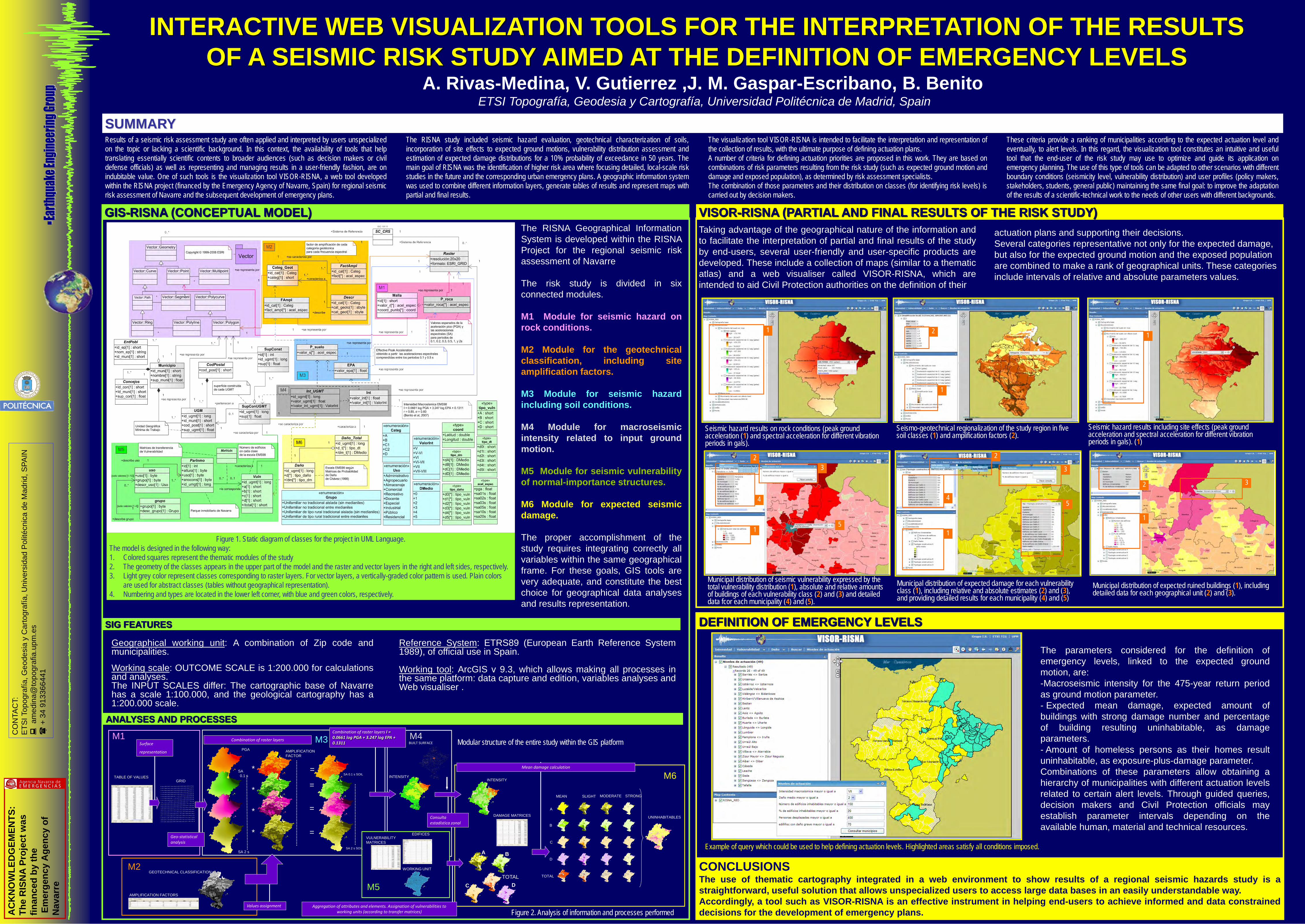
The RISNA Geographical InformationSystem is developed within the RISNAProject for the regional seismic riskassessment of Navarre

The risk study is divided in sixconnected modules.

M1 Module for seismic hazard onrock conditions.

M2 Module for the geotechnicalclassification, including siteamplification factors.

M3 Module for seismic hazardincluding soil conditions.

M4 Module for macroseismicintensity related to input groundmotion.

M5 Module for seismic vulnerabilityof normal-importance structures.

M6 Module for expected seismicdamage.

The proper accomplishment of thestudy requires integrating correctly allvariables within the same geographicalframe. For these goals, GIS tools arevery adequate, and constitute the bestchoice for geographical data analysesand results representation.

Figure 1. Static diagram of classes for the project in UML Language.The model is designed in the following way:1. Colored squares represent the thematic modules of the study2. The geometry of the classes appears in the upper part of the model and the raster and vector layers in the right and left sides, respectively.3. Light grey color represent classes corresponding to raster layers. For vector layers, a vertically-graded color pattern is used. Plain colors

are used for abstract classes (tables without geographical representation).4. Numbering and types are located in the lower left corner, with blue and green colors, respectively.

DEFINITION OF EMERGENCY LEVELS

The parameters considered for the definition ofemergency levels, linked to the expected groundmotion, are:-Macroseismic intensity for the 475-year return periodas ground motion parameter.- Expected mean damage, expected amount ofbuildings with strong damage number and percentageof building resulting uninhabitable, as damageparameters.- Amount of homeless persons as their homes resultuninhabitable, as exposure-plus-damage parameter.Combinations of these parameters allow obtaining ahierarchy of municipalities with different actuation levelsrelated to certain alert levels. Through guided queries,decision makers and Civil Protection officials mayestablish parameter intervals depending on theavailable human, material and technical resources.

Seismic hazard results on rock conditions (peak ground acceleration (1) and spectral acceleration for different vibration periods in gals).

Seismo-geotechnical regionalization of the study region in five soil classes (1) and amplification factors (2).

Seismic hazard results including site effects (peak ground acceleration and spectral acceleration for different vibration periods in gals). (1)

Figure 2. Analysis of information and processes performed

The RISNA study included seismic hazard evaluation, geotechnical characterization of soils,incorporation of site effects to expected ground motions, vulnerability distribution assessment andestimation of expected damage distributions for a 10% probability of exceedance in 50 years. Themain goal of RISNA was the identification of higher risk area where focusing detailed, local-scale riskstudies in the future and the corresponding urban emergency plans. A geographic information systemwas used to combine different information layers, generate tables of results and represent maps withpartial and final results.

The visualization tool VISOR-RISNA is intended to facilitate the interpretation and representation ofthe collection of results, with the ultimate purpose of defining actuation plans.A number of criteria for defining actuation priorities are proposed in this work. They are based oncombinations of risk parameters resulting from the risk study (such as expected ground motion anddamage and exposed population), as determined by risk assessment specialists.The combination of those parameters and their distribution on classes (for identifying risk levels) iscarried out by decision makers.

These criteria provide a ranking of municipalities according to the expected actuation level andeventually, to alert levels. In this regard, the visualization tool constitutes an intuitive and usefultool that the end-user of the risk study may use to optimize and guide its application onemergency planning. The use of this type of tools can be adapted to other scenarios with differentboundary conditions (seismicity level, vulnerability distribution) and user profiles (policy makers,stakeholders, students, general public) maintaining the same final goal: to improve the adaptationof the results of a scientific-technical work to the needs of other users with different backgrounds.

Taking advantage of the geographical nature of the information andto facilitate the interpretation of partial and final results of the studyby end-users, several user-friendly and user-specific products aredeveloped. These include a collection of maps (similar to a thematicatlas) and a web visualiser called VISOR-RISNA, which areintended to aid Civil Protection authorities on the definition of their

actuation plans and supporting their decisions. Several categories representative not only for the expected damage, but also for the expected ground motion and the exposed population are combined to make a rank of geographical units. These categories include intervals of relative and absolute parameters values.

Example of query which could be used to help defining actuation levels. Highlighted areas satisfy all conditions imposed.

ANALYSES AND PROCESSES

SIG FEATURES

Modular structure of the entire study within the GIS platformM1

M2

M3 M4

M5

M6

1 2

1

1

1

23

4

5

Municipal distribution of expected ruined buildings (1), including detailed data for each geographical unit (2) and (3).

1

32

Geographical working unit: A combination of Zip code andmunicipalities.

Working scale: OUTCOME SCALE is 1:200.000 for calculationsand analyses.The INPUT SCALES differ: The cartographic base of Navarrehas a scale 1:100.000, and the geological cartography has a1:200.000 scale.

Reference System: ETRS89 (European Earth Reference System1989), of official use in Spain.

Working tool: ArcGIS v 9.3, which allows making all processes inthe same platform: data capture and edition, variables analyses andWeb visualiser .

Municipal distribution of expected damage for each vulnerability class (1), including relative and absolute estimates (2) and (3), and providing detailed results for each municipality (4) and (5)

1

2

3

45

Municipal distribution of seismic vulnerability expressed by the total vulnerability distribution (1), absolute and relative amounts of buildings of each vulnerability class (2) and (3) and detailed data fcor each municipality (4) and (5).

AC

KN

OW

LED

GEM

ENTS

: Th

e R

ISN

A Pr

ojec

t was

fin

ance

d by

the

Emer

genc

y A

genc

y of

N

avar

re