gis responds to three fundamental questionspages.geo.wvu.edu/~elmes/geog350/lecture5.pdf ·...
TRANSCRIPT

Lecture 5
Putting Maps in GIS
9/16/2005 2
GIS responds to three fundamental questions by automating spatial data:“What is where?”“Why is it there?”
GIS reveals linkagesunevenly distributed social, economic and
environmental influences“What if ......?”
GIS provides geographical context for alternative policy analysis
9/16/2005 3
Representing Spatial Phenomena
Objects as symbols
Thematic Map: Choropleth
Continuous variation: Surface
Isoline map: ContoursCustomer Locations
Census TractsRoadsShopping CentersMountains & Rivers
WarehousesZip CodesCompetitor LocationsService/Sales TerritoriesStore Locations
Why Use Maps?
Because everything we manage is located somewhere:
... and is somehow connected.
Wildlife
9/16/2005 5
GIS Coordinates Multiple Map LayersMaps from different sourcesDifferent features and symbolsDifferent scales and areal units
Streets
Counties
Area Codes
ZIP Codes
States
Census Tracts
Maps and GISMaps are the main source of data for GISTraditions of cartography are fundamentally important to GISGIS has roots in the analysis of information on maps, and overcomes many of the limitations of manual analysis
this lecture is about cartography and its relationship to GISHow does GIS differ from cartography?
WHAT IS A MAP?DefinitionMaps show more than the Earth's surfaceTypes of maps
Thematic maps in GISLine maps versus photo maps
Characteristics of maps
DefinitionAccording to the International Cartographic Association (ICA), amap is:
a representation, normally to scale and on a flat medium, of a selection of material or abstract features on, or in relation to, the surface of the Earth
Maps show more than the Earth's surfacethe term "map" is often used in mathematics to convey the notionof transferring information from one form to another, just as cartographers transfer information from the surface of the Earthto a sheet of paperthe term "map" is used loosely to refer to any visual display ofinformation, particularly if it is abstract, generalized or schematic
9/16/2005 9
Definition of “Map”NOUN or VERBSTATIC or ACTIVEOBJECT or PROCESSAll of the above
Maps show more than the Earth's surface
Production of a map requires:Selection of the few features in the real world to includeClassification of selected features into groups (i.e. bridges, churches, railways)Simplification of jagged lines like coastlinesExaggeration of features to be included that are to small to show at the scale of the mapSymbolization to represent the different classes of features chosen
Types of mapsIn practice we normally think of two types of map:Topographic map - a reference tool, showing the outlines of selected natural and man-made features of the Earth
often acts as a frame or base map for other information"Topography" refers to the shape of the surface, represented by contours and/or shading, but topographic maps also show roads and other prominent features
Thematic map - a tool to communicate geographical concepts such as the distribution of population densities, climate, movement of goods, land use, etc.
Thematic maps in GISSeveral types of thematic map are important in GIS:
choropleth map - uses reporting zones such as counties or census tracts to show data such as average incomes, percent female, or rates of mortality
the boundaries of the zones or areal units are established independently of the data, and may be used to report many different sets of data
area class map - shows zones of constant attributes, such as vegetation, soil type, or forest species
the boundaries are different for each map as they are determined by the variation of the attribute being mapped, e.g. breaks of soil type may occur independently of breaks of vegetation
9/16/2005 13
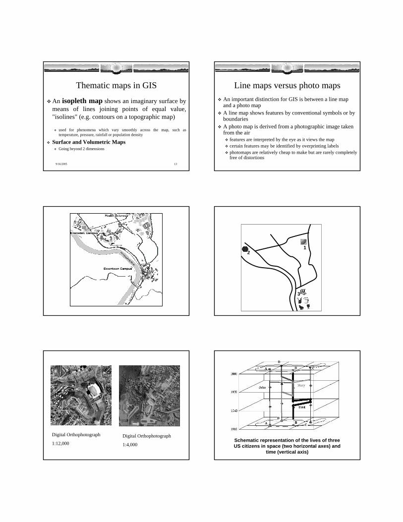
Thematic maps in GIS
An isopleth map shows an imaginary surface by means of lines joining points of equal value, "isolines" (e.g. contours on a topographic map)
used for phenomena which vary smoothly across the map, such as temperature, pressure, rainfall or population density
Surface and Volumetric MapsGoing beyond 2 dimensions
Line maps versus photo mapsAn important distinction for GIS is between a line map and a photo mapA line map shows features by conventional symbols or by boundariesA photo map is derived from a photographic image taken from the air
features are interpreted by the eye as it views the mapcertain features may be identified by overprinting labelsphotomaps are relatively cheap to make but are rarely completelyfree of distortions
12
3
Digital Orthophotograph
1:12,000Digital Orthophotograph
1:4,000Schematic representation of the lives of three US citizens in space (two horizontal axes) and
time (vertical axis)

Characteristics of MapsMaps are often stylized, generalized or abstracted, requiring careful interpretationUsually out of dateShow only a static situation - one slice in timeOften highly elegant/artisticEasy to use to answer certain types of questions
Where is it?But not “How much”
9/16/2005 20
The Traditional MapA long and rich historyHas a scale or representative fraction
The ratio of distance on the map to distance on the ground
Is a major source of data for GISObtained by digitizing or scanning the map and registering it tothe Earth’s surface
Digital representations are much more powerful than their paper equivalents
The First Known Map?The Bedolina Petroglyph;
Valcamonica,Italy, Circa 2500
BCE
Plan of settlement
The earliest map:
Catal Hyuk (6200BC)
Ptolemic map (13th century AD)Jodocus Hondius 1595AD

WHAT ARE MAPS USED FOR?Traditionally, maps are used as aids to navigation, as reference documents, and as wall decorationsmaps have four roles today:
DATA DISPLAYDATA STORESPATIAL INDEXDATA ANALYSIS – producing useful information
Data DisplayMaps provide useful ways of displaying information in a meaningful way
In practice, the cost of making and printing a map is highMap contents are often a compromise between different needs
Data StorageAs a means of storing data, maps can be very efficient, high density stores
a typical 1:50,000 map might have 1,000 place names on itthe information printed on the typical 1:50,000 topographic map sheet in the UK requires 25 million bytes of storage when it is converted to digital form, equivalent to one standard computer tape, or 10 full-length novels
Spatial IndexesCoordinate systems - locationA map can show the boundaries of areas (e.g. land use zones, soil or rock types) and identify each area with a label
a separate manual with corresponding entries may provide greater detail about each area
Data AnalysisMaps are used in analysis to:
Make or test hypotheses, such as the identification of cancer clustersExamine the relationship between two distributions using simple transparent overlays
THE USE OF MAPS FOR INVENTORY AND ANALYSISExamples demonstrate how maps have been used for sophisticated applications in inventory and analysis, and point out some limitations

Measuring land use changeTwo major land use surveys were carried out in the UK, in the late 1930s by Sir Dudley Stamp and in the 1960s by Professor Alice Coleman
the results were published as mapsin order to compare changes in land use between 1930s and 1960s, the area of each land use type was measured using a handplanimeter and counting overlaid dots
Despite interest in measuring the amount of change of land use through time, particularly from agricultural to urban, few results were produced using this method because the traditional techniques are slow and tedious, and because of the difficulty of overlaying or working from very different map sources
Landscape architectureIan McHarg pioneered the use of transparent map overlays for planning locations of highways, transmission corridors and other facilities in environmentally sensitive areas (McHarg, 1969)
despite the popularity of this technique and numerous applications, this method remains cumbersome and imprecise without the use of computers and GIS.
9/16/2005 33
GIS and MappingAUTOMATED AND COMPUTER-
ASSISTED CARTOGRAPHY
Change to computer mappingpersonalities were critically important in the 1960s and early 1970s - individual interests determined the direction and focus of research and development in computer cartography (see Rhind, 1988)
Impetus for change began in two communities
Two CommunitiesCommunity #1.
Scientists wishing to make maps quickly to see the results of modeling, or to display data from large archives already in digital form, e.g. census tablesquality not a major concernSYMAP was the first significant package for this purpose, released by the Harvard Lab in 1967
Community #2. Cartographers seeking to reduce the cost and time of map production and editing
hardware costs limited interest in this technology prior to 1980 to the major mapping agencies – now it is universally available on Pcs and PDAsthe costs of computing have dropped by an order of magnitude every six yearsan early belief that the entire map-making process could be automated diminished by 1975 because of difficulties of generalization and design
Advantages of computer cartographyLower cost for simple maps, faster productionGreater flexibility in output - easy scale or projection change - maps can be tailored to user needsMany other uses for digital data
Disadvantages of Computer Cartography
High initial capital cost, though this is now much reducedComputer methods do not ensure production of maps of high quality
Loss of regard for the “cartographic tradition” with the consequent production of “cartojunk”GIS- easy to make Bad Maps
Cost-benefit analysis difficult
GIS and Computer CartographyComputer cartography has a primary goal of producing maps
Systems have advanced tools for map layout, placement of labels, large symbol and font libraries, interfaces for expensive, high quality output devicesNot an analytical toolUnlike data for GIS, cartographic data does not need to be stored in ways which allow analysis of relationships between different themes, such as population density and housing prices or the routing of flows along connecting highway or river segmentsDisplay only