gis strategic plan - tigard, or - official · pdf filecity of tigard gis strategic plan ......
TRANSCRIPT
City of Tigard GIS Strategic Plan
Page 2 of 36
Document prepared by Finance and Information Services.
Reviewed and endorsed by the GIS Coordinating Group.
Approved by Tigard Executive Staff July 8, 2014.
GIS Coordinating Group
Public Works, John Goodrich Public Works, Paul Izatt
Public Works, Sara Doughty Library, Joyce Niewendorp
Community Development, Tom McGuire Community Development, Agnes Kowacz Community Development, Tim Lehrbach
Police, Gayla Shillitto City Management, Loreen Mills
Finance & Information Services, Toby LaFrance Finance & Information Services, Louis Sears
Finance & Information Services, Nathan Shaub Finance & Information Services, Preston Beck
O R E G O N
City of Tigard GIS Strategic Plan
Page 3 of 36
Table of Contents Page Executive Summary…………………………………………………………………..... 4 GIS Strategic Plan……………………………………………………………...…....…. 9
Introduction…………………………………………………………………… 9 Process…...………………………………………………………………….… 9 Background………………………………………………………………….… 9 GIS Program Overview……………………………………………………...… 10
Trends Impacting GIS……………………..…………………………………….….…. 16 Policy Decisions Impacting GIS…..………..………………………………………….. 20 Organizational Evaluation……………….….……….……………………………...….. 21 Analysis of Interviews –Major Issues…………………………………………………... 25 GIS Vision, Goals, Objectives……………………………..…………………………... 32 Appendix: GIS Executive Team/GIS Technical Team………………………….... 34 References………………………………………………………………………….. 36
City of Tigard GIS Strategic Plan
Page 4 of 36
Executive Summary Purpose The purpose of this GIS (Geographic Information System) Strategic Plan is to define a common unified vision and establish a mutual framework for city departments to efficiently and effectively use and improve the city’s use of GIS technology. This plan builds upon the successes of the previous GIS Strategic Plan, evaluates present conditions, assesses industry trends, and prepares a road map for the future of GIS at the city. Business Case Key business case drivers for this plan include:
• Ensuring the efficient provision of geospatial data and services resulting in cost-savings for the delivery of city services, and management of city assets and property
• Ensuring continued improvement of workflows and business process improvements resulting from GIS applications integrated with city business systems
• Ensuring strategic business driven deployment/acquisition of GIS related technologies and geospatial data to improve services and operations
• Extending city services by providing citizens and businesses with access to geospatial data in the form of easy to use applications to stay informed and provide input about the community in a method that saves them and the city time and money
• Centralized administration of a city-wide information system to ensure efficient use of data, applications, and GIS related resources to reduce redundancy and duplications of efforts
• Regional coordination initiatives to produce cost-savings, public safety benefits, and economies of scale from large data acquisitions
Key Recommendations of the Plan The following are key recommendations of this strategic planning process. Focus on Content Management A recurring theme through the SWOT analysis was one of not being able to easily search for GIS related data or users not knowing if certain GIS data exists even if it is readily accessible. It appears there is an issue not so much with a lack of data but with management of that data (content management). The amount of data we have built has become difficult to navigate when trying to find something new or unfamiliar. The first phase of the GIS program focused on infrastructure building and data conversion. While we have been successful at building a large GIS database, we now need to focus on better organizing that information. This plan

City of Tigard GIS Strategic Plan
Page 5 of 36
recommends new emphasis on solutions and methods to improve upon intuitive access, and ease of use of the city’s large repository of geospatial data. GIS Supports City Strategic Plan Priorities
As the city strategic plan is implemented, GIS must be at the ready with the data and analytical tools and skills to develop the right information to help staff, the public, and City Council make the most informed decisions. Currently various analytical methods needed for assessing/measuring walkability within the City are not fully developed, such as routing (network analysis) and need development. Additionally, the data needs of a city focusing on walkability will mean a more fine-grained mapping base than is currently available. It is recommended that this plan align City Strategic Plan goals and objectives with GIS Strategic Plan and the subsequent GIS Implementation Plan to ensure progress and ultimately success on the city’s goals and objectives.
Establish Modified GIS Governance To better align GIS resources with the GIS program objectives along with the City’s most pressing needs, a modified GIS governance model is recommended. The new governance model employs a senior level Steering Committee to replace the existing GIS Coordinating Group to focus on high level programmatic decision-making related to the GIS program and GIS strategic plan. In addition, the Plan defines a GIS stakeholder committee that will be charged with improving operational efficiency of GIS data and applications. Significant GIS-based improvements would be recommended to the senior level Steering Committee for consideration in the GIS Work Plan. Descriptions of the Steering Committee and GIS Stakeholder committee are described in the Appendix. Evaluate GIS Capability Maturity Model A key challenge facing Tigard’s GIS program in achieving its goals is securing the right mix of resources to sustain a growing system. GIS has been widely deployed in many government agencies. Recently studies have shown that GIS use can deliver significant return on investment (ROI). Annual ROI rates of 10:1 or more have been documentedi. However within the field of GIS management there is still a sense of vulnerability of GIS programs and that the ROI potential is not fully understood. Recently the GIS Management Institute developed tools to assess the characteristics of an organization’s GIS; an assessment of both enabling capability (technology, data, and infrastructure) and execution ability (GIS management and professional staff). To provide better and more reliable definition of the required resources to manage the GIS program, this plan recommends employing the GIS Capability Maturity Model and its companion the Geospatial Management Competency Model. Enhanced Responsive Application Development Another recurring theme from the SWOT analysis was the need for applications that perform specific functions and do so quickly. While the previous GIS strategic plan resulted in robust
City of Tigard GIS Strategic Plan
Page 6 of 36
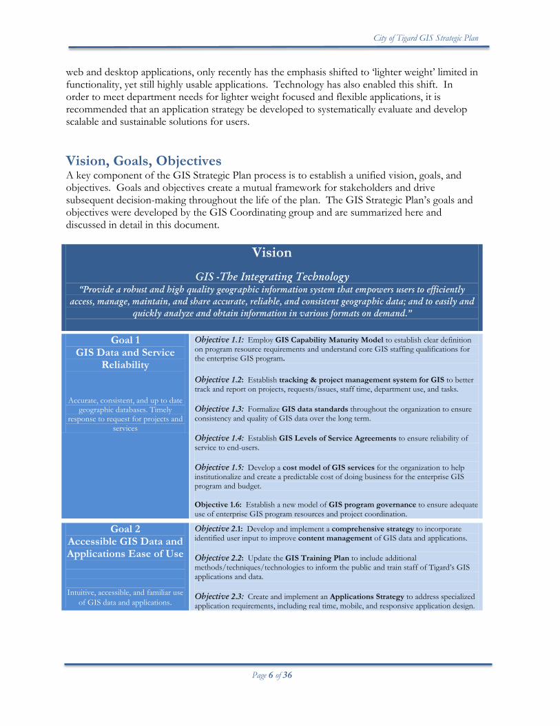
web and desktop applications, only recently has the emphasis shifted to ‘lighter weight’ limited in functionality, yet still highly usable applications. Technology has also enabled this shift. In order to meet department needs for lighter weight focused and flexible applications, it is recommended that an application strategy be developed to systematically evaluate and develop scalable and sustainable solutions for users. Vision, Goals, Objectives A key component of the GIS Strategic Plan process is to establish a unified vision, goals, and objectives. Goals and objectives create a mutual framework for stakeholders and drive subsequent decision-making throughout the life of the plan. The GIS Strategic Plan’s goals and objectives were developed by the GIS Coordinating group and are summarized here and discussed in detail in this document.
Vision
GIS -The Integrating Technology “Provide a robust and high quality geographic information system that empowers users to efficiently
access, manage, maintain, and share accurate, reliable, and consistent geographic data; and to easily and quickly analyze and obtain information in various formats on demand.”
Goal 1
GIS Data and Service Reliability
Accurate, consistent, and up to date geographic databases. Timely
response to request for projects and services
Objective 1.1: Employ GIS Capability Maturity Model to establish clear definition on program resource requirements and understand core GIS staffing qualifications for the enterprise GIS program. Objective 1.2: Establish tracking & project management system for GIS to better track and report on projects, requests/issues, staff time, department use, and tasks. Objective 1.3: Formalize GIS data standards throughout the organization to ensure consistency and quality of GIS data over the long term. Objective 1.4: Establish GIS Levels of Service Agreements to ensure reliability of service to end-users. Objective 1.5: Develop a cost model of GIS services for the organization to help institutionalize and create a predictable cost of doing business for the enterprise GIS program and budget. Objective 1.6: Establish a new model of GIS program governance to ensure adequate use of enterprise GIS program resources and project coordination.
Goal 2 Accessible GIS Data and Applications Ease of Use
Intuitive, accessible, and familiar use of GIS data and applications.
Objective 2.1: Develop and implement a comprehensive strategy to incorporate identified user input to improve content management of GIS data and applications. Objective 2.2: Update the GIS Training Plan to include additional methods/techniques/technologies to inform the public and train staff of Tigard’s GIS applications and data. Objective 2.3: Create and implement an Applications Strategy to address specialized application requirements, including real time, mobile, and responsive application design.
City of Tigard GIS Strategic Plan
Page 7 of 36
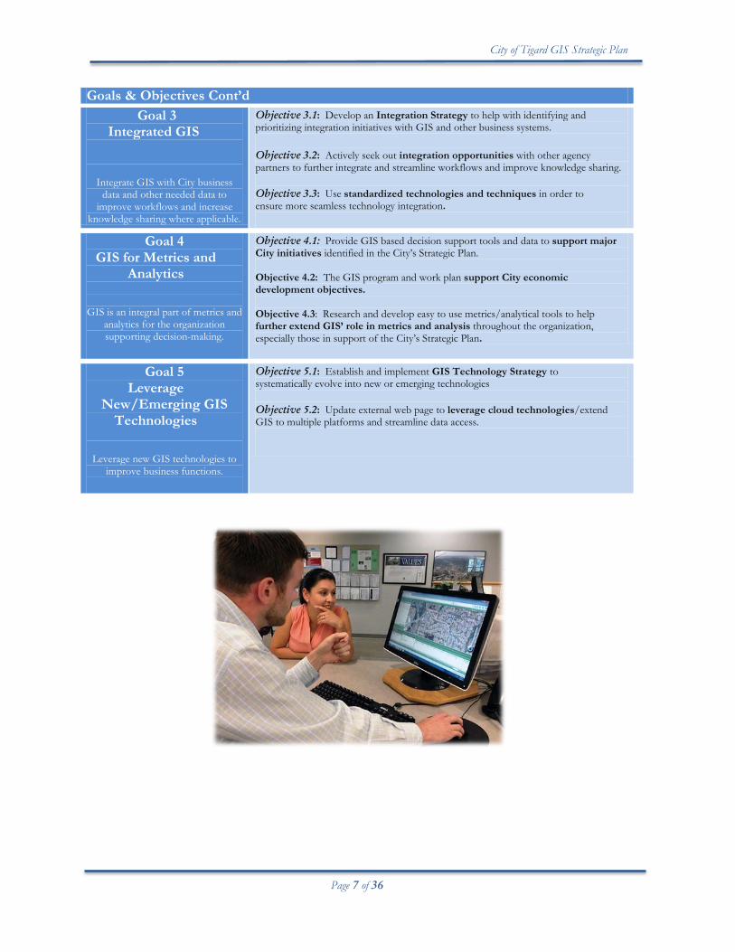
Goals & Objectives Cont’d
Goal 3 Integrated GIS
Integrate GIS with City business data and other needed data to
improve workflows and increase knowledge sharing where applicable.
Objective 3.1: Develop an Integration Strategy to help with identifying and prioritizing integration initiatives with GIS and other business systems. Objective 3.2: Actively seek out integration opportunities with other agency partners to further integrate and streamline workflows and improve knowledge sharing. Objective 3.3: Use standardized technologies and techniques in order to ensure more seamless technology integration.
Goal 4 GIS for Metrics and
Analytics
GIS is an integral part of metrics and
analytics for the organization supporting decision-making.
Objective 4.1: Provide GIS based decision support tools and data to support major City initiatives identified in the City’s Strategic Plan. Objective 4.2: The GIS program and work plan support City economic development objectives.
Objective 4.3: Research and develop easy to use metrics/analytical tools to help further extend GIS’ role in metrics and analysis throughout the organization, especially those in support of the City’s Strategic Plan.
Goal 5 Leverage
New/Emerging GIS Technologies
Leverage new GIS technologies to improve business functions.
Objective 5.1: Establish and implement GIS Technology Strategy to systematically evolve into new or emerging technologies Objective 5.2: Update external web page to leverage cloud technologies/extend GIS to multiple platforms and streamline data access.
City of Tigard GIS Strategic Plan
Page 8 of 36
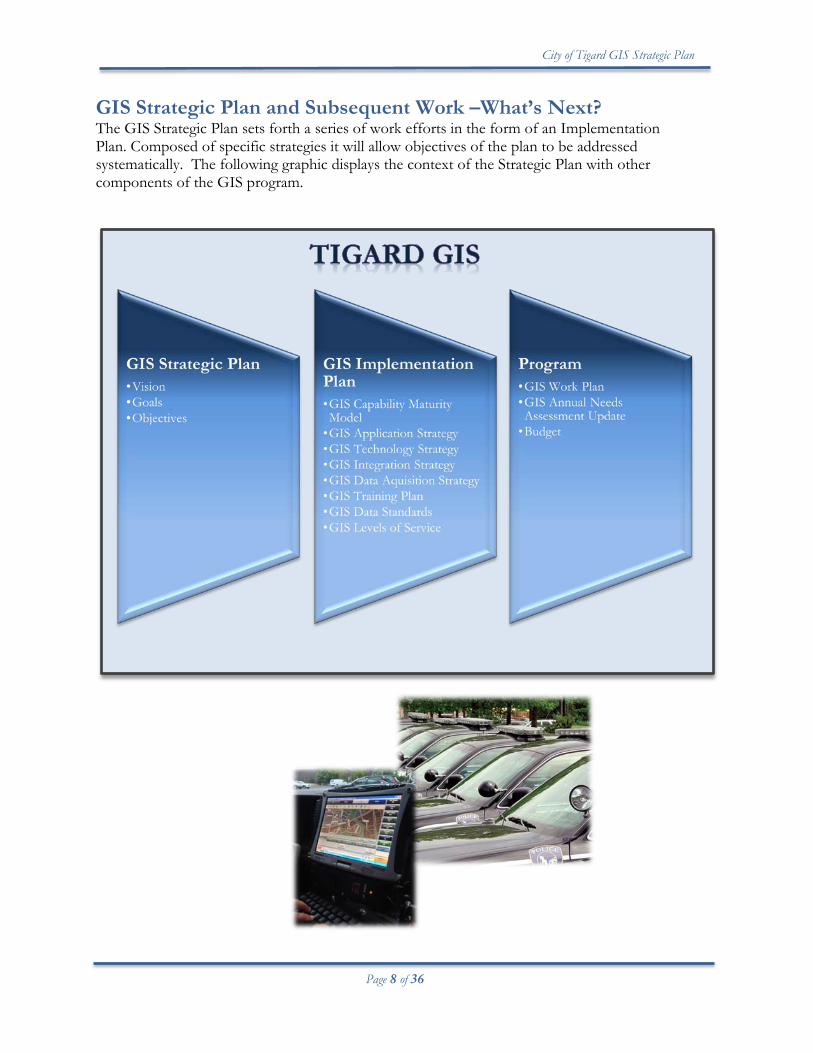
GIS Strategic Plan and Subsequent Work –What’s Next? The GIS Strategic Plan sets forth a series of work efforts in the form of an Implementation Plan. Composed of specific strategies it will allow objectives of the plan to be addressed systematically. The following graphic displays the context of the Strategic Plan with other components of the GIS program.

City of Tigard GIS Strategic Plan
Page 9 of 36
GIS Strategic Plan Introduction The 2014 GIS Strategic Plan is intended to establish a unified vision and to guide decision-making and resources of the citywide Geographic Information System (GIS) for the City of Tigard. The previous GIS Strategic Plan (2006) focused on core infrastructure building and establishing centralized management and operation of a citywide or enterprise GIS. With most of the plan elements completed, the 2014 GIS Strategic Plan will focus on the next five years, emphasizing GIS as the ‘integrating technology.’ In the last decade, GIS technology has become highly pervasive in our society. It is emerging as a platform for doing many common city business functions. With much of the core infrastructure in place and GIS institutionalized within the organization, it is now possible to move to the next generation with our GIS. This is a GIS that is highly integrated with city business functions, easy to use, intuitive, available anywhere on multiple devices, provides near real time information, is part of the social media platform, leverages 3D visualization capabilities, and most importantly is highly supportive in analysis and metrics in decision-making for city business functions and city strategic initiatives. Process The GIS Section held work sessions with city departments as well as the Neighborhood Network Committee to get an understanding of the City’s GIS needs landscape and helped shape a unified vision for this plan. In addition, the GIS Section regularly keeps up on the technology landscape in order to understand where the fast past world of GIS technology is moving, as well as assessing other related technologies that directly impact use of GIS. The GIS Coordinating Group (GISCG) is the main oversight group that reviews the planning process of the GIS strategic plan and provides direction and feedback during its evolution. The Executive Staff, composed of department directors, is the final review body that approves the Plan. Background A Geographic Information System (GIS) is proven technology that has been in use for several decades by many government agencies and other organizations as a decision support tool and information management system. GIS provides the capability to collect, manage, manipulate, analyze, and share information that is location based. Information is ‘layered’ in a map-based environment to provide a better visual image of location, patterns and relationships. GIS is integrating technology that touches numerous business processes, systems, data, and other applications. As such, it is an integral part of the decision-support infrastructure that contributes to the success of Tigard’s delivery of services and operations.
City of Tigard GIS Strategic Plan
Page 10 of 36
The City has routinely used GIS, since 1989. In 2006, the city embarked on a major city-wide core ‘infrastructure’ building effort to consolidate and modernize its GIS. At the time, a significant amount of the City’s GIS data was compartmentalized or was paper based, resulting in data redundancy and lack of data sharing amongst departments. Since then data has been centralized, converted to common GIS formats, and applications have been built to access the data which significantly improved the accessibility, timeliness and availability of information to both staff and the public.
2006 GIS Strategic Plan In 2006, the City of Tigard completed a GIS Strategic Plan. This plan contained key strategic initiatives to create a more efficient centralized model for the City’s GIS which had previously been loosely organized into department-centric GIS silos with little coordination amongst departments. These key strategic initiatives included:
• Develop and implement an enterprise GIS Strategic plan • Conduct a pilot project • Establish a system architecture hardware/software
environment • Develop overarching citywide GIS data model and
geodatabase models to support business processes • Migrate and convert data • Develop GIS standards and procedures • Develop a centralized web-based mapping application • Implement priority business system integration • Develop a GIS training plan • Develop an ongoing centrally managed GIS program
These initiatives gave rise to a multi-year project involving core infrastructure building, formalized governance and institutionalization of a functioning enterprise GIS with centralized management which serves all departments and the public. GIS Program Overview Tigard’s GIS provides a platform for the City to improve service delivery through better informed operations and decision-making. The GIS Section is focused on delivering quality service to the organization through a commitment to operational efficiency, information management and analysis, and research. GIS is an integral part of many city functions, including operations, administration, planning, public safety, emergency operations, regulation and
City of Tigard GIS Strategic Plan
Page 11 of 36
permitting, analysis, and communication. In addition, the City’s GIS is available to the public in the form of interactive maps, printable maps, and focused applications providing a rich self-service system demonstrating quality customer service and transparency of city government. Benefits of the City’s GIS Program Many GIS benefits are qualitative, such as improved collaboration, better decision-making, and more efficient business processes. These efficiencies, when provided by a mature GIS, can have a significant impact on a city’s financial bottom line. Geographical Information Systems are unique in that they attempt to satisfy support for many lines of business by standardizing approaches to many spatial and functionally similar, but organizationally dissimilar issues. GIS Benefits can be loosely categorized under three closely related general areas: 1) Operational/Business Process Efficiency, 2) Decision-making and Policy Support, and 3) Transparency and Public Information.
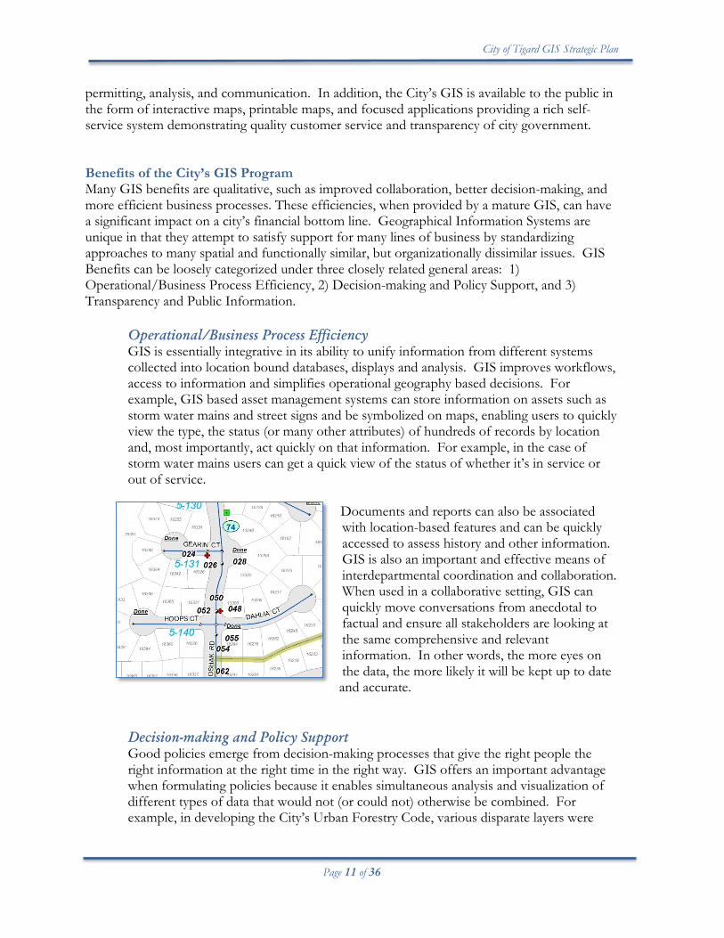
Operational/Business Process Efficiency GIS is essentially integrative in its ability to unify information from different systems collected into location bound databases, displays and analysis. GIS improves workflows, access to information and simplifies operational geography based decisions. For example, GIS based asset management systems can store information on assets such as storm water mains and street signs and be symbolized on maps, enabling users to quickly view the type, the status (or many other attributes) of hundreds of records by location and, most importantly, act quickly on that information. For example, in the case of storm water mains users can get a quick view of the status of whether it’s in service or out of service.
Documents and reports can also be associated with location-based features and can be quickly accessed to assess history and other information. GIS is also an important and effective means of interdepartmental coordination and collaboration. When used in a collaborative setting, GIS can quickly move conversations from anecdotal to factual and ensure all stakeholders are looking at the same comprehensive and relevant information. In other words, the more eyes on the data, the more likely it will be kept up to date and accurate.
Decision-making and Policy Support Good policies emerge from decision-making processes that give the right people the right information at the right time in the right way. GIS offers an important advantage when formulating policies because it enables simultaneous analysis and visualization of different types of data that would not (or could not) otherwise be combined. For example, in developing the City’s Urban Forestry Code, various disparate layers were
City of Tigard GIS Strategic Plan
Page 12 of 36
combined and analyzed to arrive at urban forestry policies that were acceptable to the public. These include zoning, land use, and canopy coverage from different years. In addition, GIS casts a uniquely geographic perspective on information: spatial patterns can be analyzed. GIS can inform decision-making at all levels of city government in meaningful ways. Better basic information for operational plans can yield significant results when allocating resources. Where are the crime hotspots, where are the police calls for service concentrated? Which intersections have the greatest numbers of pedestrian accidents? More comprehensive GIS analysis can create significant efficiencies in the development of plans for infrastructure and facility projects, such as locating a high capacity transit, libraries, trails, and other facilities. Transparency and Public Information GIS increases city government transparency and can act as a first line of response for public inquires. A mapping front end organizes information in a way that is intuitive to the public. For example, the city publishes reported crime information in a simple mapping application that merely requires the user to enter an address. From there, up to 24 different crime categories can be viewed in a half-mile buffer around a given address. This online mapping application also allows members of the community to view property values, view planning and zoning information, see permit activity for a given parcel, see what underlying natural hazards exists, see where the public infrastructure projects are, and list many other services that are available. Offering these services to the public frees up city staff to focus on other tasks while extending the availability of city services beyond normal business hours. This same approach can be applied to virtually any internal process that does not have a legal confidentiality constraint and has been integrated with the GIS database.
Organizational Structure One of the outcomes of the 2006 GIS Strategic Plan was to establish an enterprise GIS organizational structure that would provide ongoing support and operation of GIS functions. The City settled on a hybrid model using both centralized and decentralized features to operate its enterprise GIS.
Centralized Centralized are GIS administration, GIS program management, GIS database development and administration, application development, system monitoring, external GIS coordination/data procurement, base map maintenance, training and department technical support. GIS analysis and mapping is also provided to departments without GIS trained staff or backup support. Currently a GIS Coordinator and GIS Programmer Analyst provide centralized support functions for the enterprise GIS. Decentralized Decentralized within the organization is maintenance and analysis of department specific data and output related to department specific initiatives. This decentralized decision
City of Tigard GIS Strategic Plan
Page 13 of 36
was made because departments know and understand their data best and should therefore assume maintenance responsibility. Each data layer within the organization contains a GIS Data Stewardship agreement which specifies layer ownership and maintenance responsibility. Public Works, Community Development and Police each have staff performing data maintenance and analysis.
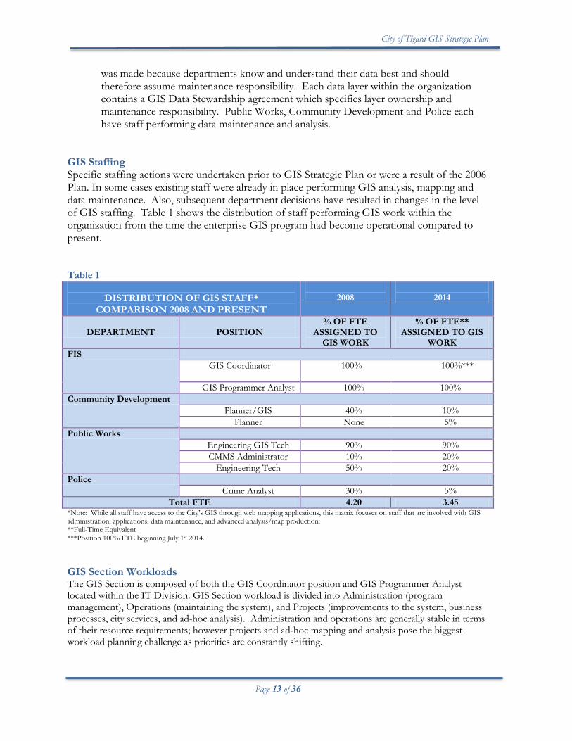
GIS Staffing Specific staffing actions were undertaken prior to GIS Strategic Plan or were a result of the 2006 Plan. In some cases existing staff were already in place performing GIS analysis, mapping and data maintenance. Also, subsequent department decisions have resulted in changes in the level of GIS staffing. Table 1 shows the distribution of staff performing GIS work within the organization from the time the enterprise GIS program had become operational compared to present. Table 1
DISTRIBUTION OF GIS STAFF* COMPARISON 2008 AND PRESENT
2008
2014
DEPARTMENT
POSITION
% OF FTE ASSIGNED TO
GIS WORK
% OF FTE** ASSIGNED TO GIS
WORK FIS
GIS Coordinator
100% 100%***
GIS Programmer Analyst 100% 100% Community Development
Planner/GIS 40% 10% Planner None 5%
Public Works Engineering GIS Tech 90% 90% CMMS Administrator 10% 20%
Engineering Tech 50% 20% Police
Crime Analyst 30% 5% Total FTE 4.20 3.45
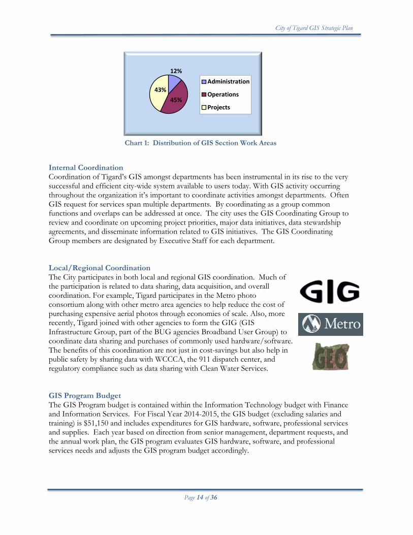
*Note: While all staff have access to the City’s GIS through web mapping applications, this matrix focuses on staff that are involved with GIS administration, applications, data maintenance, and advanced analysis/map production. **Full-Time Equivalent ***Position 100% FTE beginning July 1st 2014. GIS Section Workloads The GIS Section is composed of both the GIS Coordinator position and GIS Programmer Analyst located within the IT Division. GIS Section workload is divided into Administration (program management), Operations (maintaining the system), and Projects (improvements to the system, business processes, city services, and ad-hoc analysis). Administration and operations are generally stable in terms of their resource requirements; however projects and ad-hoc mapping and analysis pose the biggest workload planning challenge as priorities are constantly shifting.
City of Tigard GIS Strategic Plan
Page 14 of 36
Chart 1: Distribution of GIS Section Work Areas
Internal Coordination Coordination of Tigard’s GIS amongst departments has been instrumental in its rise to the very successful and efficient city-wide system available to users today. With GIS activity occurring throughout the organization it’s important to coordinate activities amongst departments. Often GIS request for services span multiple departments. By coordinating as a group common functions and overlaps can be addressed at once. The city uses the GIS Coordinating Group to review and coordinate on upcoming project priorities, major data initiatives, data stewardship agreements, and disseminate information related to GIS initiatives. The GIS Coordinating Group members are designated by Executive Staff for each department. Local/Regional Coordination The City participates in both local and regional GIS coordination. Much of the participation is related to data sharing, data acquisition, and overall coordination. For example, Tigard participates in the Metro photo consortium along with other metro area agencies to help reduce the cost of purchasing expensive aerial photos through economies of scale. Also, more recently, Tigard joined with other agencies to form the GIG (GIS Infrastructure Group, part of the BUG agencies Broadband User Group) to coordinate data sharing and purchases of commonly used hardware/software. The benefits of this coordination are not just in cost-savings but also help in public safety by sharing data with WCCCA, the 911 dispatch center, and regulatory compliance such as data sharing with Clean Water Services. GIS Program Budget The GIS Program budget is contained within the Information Technology budget with Finance and Information Services. For Fiscal Year 2014-2015, the GIS budget (excluding salaries and training) is $51,150 and includes expenditures for GIS hardware, software, professional services and supplies. Each year based on direction from senior management, department requests, and the annual work plan, the GIS program evaluates GIS hardware, software, and professional services needs and adjusts the GIS program budget accordingly.
12%
45% 43%
Administration
Operations
Projects
City of Tigard GIS Strategic Plan
Page 15 of 36
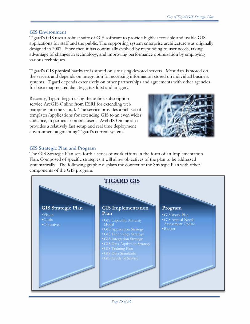
GIS Environment Tigard’s GIS uses a robust suite of GIS software to provide highly accessible and usable GIS applications for staff and the public. The supporting system enterprise architecture was originally designed in 2007. Since then it has continually evolved by responding to user needs, taking advantage of changes in technology, and improving performance optimization by employing various techniques. Tigard’s GIS physical hardware is stored on site using devoted servers. Most data is stored on the servers and depends on integration for accessing information stored on individual business systems. Tigard depends extensively on other partnerships and agreements with other agencies for base-map related data (e.g., tax lots) and imagery. Recently, Tigard began using the online subscription service ArcGIS Online from ESRI for extending web mapping into the Cloud. The service provides a rich set of templates/applications for extending GIS to an even wider audience, in particular mobile users. ArcGIS Online also provides a relatively fast setup and real time deployment environment augmenting Tigard’s current system. GIS Strategic Plan and Program The GIS Strategic Plan sets forth a series of work efforts in the form of an Implementation Plan. Composed of specific strategies it will allow objectives of the plan to be addressed systematically. The following graphic displays the context of the Strategic Plan with other components of the GIS program.
City of Tigard GIS Strategic Plan
Page 16 of 36
Trends Impacting GIS GIS is a fast paced evolving technology. With mapping becoming pervasive on the Internet and a ubiquitous integrated component of smart phones and apps in mobile devices, its pace has only increased. The following identifies trends that impact or influence decisions related to the City’s GIS program. GIS as a Platform The following is an excerpt from Jack Dangermond’s (founder and president of ESRI) plenary to the Federal User GIS Conference, February 2013: “Apps are becoming the language, more sensors resulting in Big Data - not just a hardware thing, GIS is creating loads of big data, and most important, real time big data - enter open issues, privacy matters, open computing issues and the like. The whole new world of apps is changing science, changing policy planning and more. The outcome is pervasive GIS knowledge everywhere. We have the technology that can make it pervasive on all devices - allowing new user experiences. Take the app with you and view data that are changing in real time. Apps integrate with imagery, big data, tabular data, real time sensors, social media, and more. Web maps are expressing these data in a new medium - driven via the power of the language of the web. What are web maps? They are a graphic expression pointing back to distributed services that can be visualized and analyzed. The web map points back to the original data, mashes it up, and allows us to integrate the data with live feeds, and output it in a variety of environments. Lightweight, interoperable, open... This is now being adopted by org[anizations]s all over the world for a variety of purposes - GIS as a platform.” Cloud GIS
Cloud GIS integrates all types of geographic information—maps, data, imagery, social media, crowd-sourced information, and sensor networks, and much more. As the world continues to be wired up, information is becoming much more accessible and actionable.
Cloud GIS enables ubiquitous access to geographic knowledge; it integrates the traditional work of geospatial professionals with a whole new pervasive world of apps. It takes what has been a relatively scarce commodity—geographic knowledge—and makes it abundant. And web maps provide a medium for integration and understanding, making this information widely accessible in simple forms. This widespread, easy access to geographic knowledge is what is meant by providing geography as a platform for understanding (Dangermond, 2012).
City of Tigard GIS Strategic Plan
Page 17 of 36
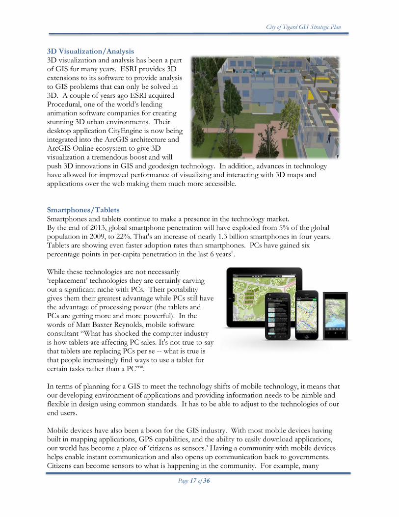
3D Visualization/Analysis 3D visualization and analysis has been a part of GIS for many years. ESRI provides 3D extensions to its software to provide analysis to GIS problems that can only be solved in 3D. A couple of years ago ESRI acquired Procedural, one of the world’s leading animation software companies for creating stunning 3D urban environments. Their desktop application CityEngine is now being integrated into the ArcGIS architecture and ArcGIS Online ecosystem to give 3D visualization a tremendous boost and will push 3D innovations in GIS and geodesign technology. In addition, advances in technology have allowed for improved performance of visualizing and interacting with 3D maps and applications over the web making them much more accessible. Smartphones/Tablets Smartphones and tablets continue to make a presence in the technology market. By the end of 2013, global smartphone penetration will have exploded from 5% of the global population in 2009, to 22%. That's an increase of nearly 1.3 billion smartphones in four years. Tablets are showing even faster adoption rates than smartphones. PCs have gained six percentage points in per-capita penetration in the last 6 yearsii. While these technologies are not necessarily ‘replacement’ technologies they are certainly carving out a significant niche with PCs. Their portability gives them their greatest advantage while PCs still have the advantage of processing power (the tablets and PCs are getting more and more powerful). In the words of Matt Baxter Reynolds, mobile software consultant “What has shocked the computer industry is how tablets are affecting PC sales. It's not true to say that tablets are replacing PCs per se -- what is true is that people increasingly find ways to use a tablet for certain tasks rather than a PC”iii. In terms of planning for a GIS to meet the technology shifts of mobile technology, it means that our developing environment of applications and providing information needs to be nimble and flexible in design using common standards. It has to be able to adjust to the technologies of our end users. Mobile devices have also been a boon for the GIS industry. With most mobile devices having built in mapping applications, GPS capabilities, and the ability to easily download applications, our world has become a place of ‘citizens as sensors.’ Having a community with mobile devices helps enable instant communication and also opens up communication back to governments. Citizens can become sensors to what is happening in the community. For example, many
City of Tigard GIS Strategic Plan
Page 18 of 36
agencies provide apps for mobile devices that allow the public to identify issues around the community (such as potholes, graffiti). Sometimes referred to as crowdsourcing, the community becomes an extension to staff and can alert the city of problems early on before they become bigger and more expensive to fix. Real Time (or Near Real Time) A number of new technologies are combining to enable the real time collection of data and the sharing of that data in real time with GIS. The result is a dynamic platform which enables real time, or near real time, visualization, analysis, and understanding. Sensors in the field (e.g., gauges, GPS, monitoring devices, mobile devices) provide real time input into GIS, which then incorporates them into the overall mapping environment to provide a more complete visualization. Further processing can set up alerts, instant messaging emails, when certain spatial criteria are crossed (geofencing). Social Media Platforms In terms of social networks and GIS there is much opportunity to be exploited for extending the reach of geospatial information beyond the mere presence of a traditional mapping home page. Social media platforms such as Facebook and Twitter have revolutionized the ways governments communicate with the public. The City of Tigard maintains an active social media presence in
regard to public relations and projects affecting the community. This is particularly true when it comes to stepping up to the real time on-demand information the public expects. Social media opens up an active dialog between the public and provides the opportunity for feedback and collaboration and publicity not available through conventional press releases. Integration with GIS can take form in mash-ups or embedding social media widgets in applications, dynamic news feeds, and
encouraging people to follow. In addition, mediums such as YouTube can offer ways to extend training/how-to opportunities of the cities GIS suite of products available to the public. GIS as a Social Media The World Wide Web has contributed to the availability of an abundance of mapping or geospatial services extending the ability of mapping to the masses. GIS is now perceived as a media, which is a fundamental paradigm shift from the back office environment of trained GIS analyst technicians making maps to 24/7 –immediate- ubiquitous mapping to almost anyone with access to the Internet. There is a growing perspective that social media are increasingly location-based. This is quite evident in the mainstream media (television, newspapers) who are increasingly relying on GIS to report news and tell stories (Sui, Goodchild, 2012). The active dialog/open environment of social media and mapping via the web has great opportunity in terms of building a stronger two-way communication medium for Tigard and the public.
City of Tigard GIS Strategic Plan
Page 19 of 36
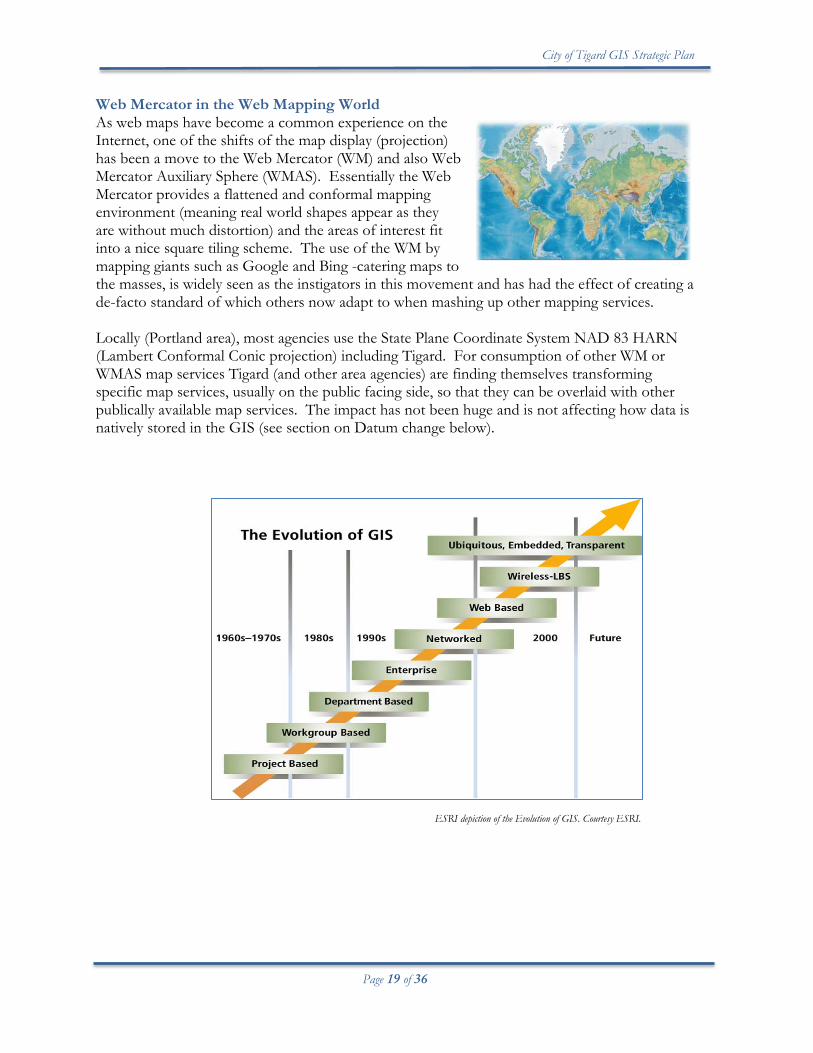
Web Mercator in the Web Mapping World As web maps have become a common experience on the Internet, one of the shifts of the map display (projection) has been a move to the Web Mercator (WM) and also Web Mercator Auxiliary Sphere (WMAS). Essentially the Web Mercator provides a flattened and conformal mapping environment (meaning real world shapes appear as they are without much distortion) and the areas of interest fit into a nice square tiling scheme. The use of the WM by mapping giants such as Google and Bing -catering maps to the masses, is widely seen as the instigators in this movement and has had the effect of creating a de-facto standard of which others now adapt to when mashing up other mapping services. Locally (Portland area), most agencies use the State Plane Coordinate System NAD 83 HARN (Lambert Conformal Conic projection) including Tigard. For consumption of other WM or WMAS map services Tigard (and other area agencies) are finding themselves transforming specific map services, usually on the public facing side, so that they can be overlaid with other publically available map services. The impact has not been huge and is not affecting how data is natively stored in the GIS (see section on Datum change below).
ESRI depiction of the Evolution of GIS. Courtesy ESRI.
City of Tigard GIS Strategic Plan
Page 20 of 36
Policy Decisions Impacting GIS This section discusses specific policy decisions that have implications for the City’s GIS. City of Tigard Strategic Plan The City of Tigard recently adopted a 20 year strategic plan. This plan lays out an ambitious vision to make Tigard the most walkable community in the Pacific Northwest. The city’s strategic plan has broad implications for GIS as a number of the goals and objectives will require GIS for metrics and analytics in order to support decision-making and monitoring of progress of the goals and objectives. For example, Goal 1 Facilitate walking connections to develop an identity has specific objectives to ensure the availability and development of a trail system for multiple types of trips. In addition, the plan emphasizes a close tie between economic development, a healthy business climate, and vision of a walkability community. Given the long term nature of this plan, ensuring adequate GIS support and tools will be very important over time. Datum Changes The State of Oregon is proposing new vertical and horizontal datums by 2022. The 2022 projects will have a significant impact. It’s akin to the adjustment from NAD83(1986) to NAD83(2011) and NGVD29 to NAVD88. Basically it means coordinates shift by well over a meter. The challenge will be in migrating old coordinates (data) onto the new datum. Tigard is not alone in this datum change and can benefit from its involvement in the GIG to coordinate how the changes will occur over time. While the year 2022 is beyond the purview of this strategic plan, the change is significant enough to warrant mentioning now as there will likely be opportunities to coordinate and be kept apprised of the status during this plan’s life.
City of Tigard GIS Strategic Plan
Page 21 of 36
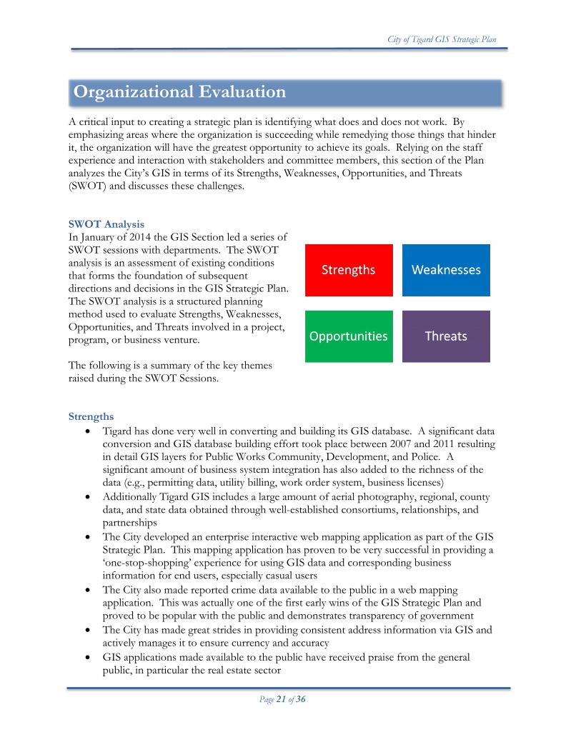
Organizational Evaluation A critical input to creating a strategic plan is identifying what does and does not work. By emphasizing areas where the organization is succeeding while remedying those things that hinder it, the organization will have the greatest opportunity to achieve its goals. Relying on the staff experience and interaction with stakeholders and committee members, this section of the Plan analyzes the City’s GIS in terms of its Strengths, Weaknesses, Opportunities, and Threats (SWOT) and discusses these challenges. SWOT Analysis In January of 2014 the GIS Section led a series of SWOT sessions with departments. The SWOT analysis is an assessment of existing conditions that forms the foundation of subsequent directions and decisions in the GIS Strategic Plan. The SWOT analysis is a structured planning method used to evaluate Strengths, Weaknesses, Opportunities, and Threats involved in a project, program, or business venture. The following is a summary of the key themes raised during the SWOT Sessions. Strengths
• Tigard has done very well in converting and building its GIS database. A significant data conversion and GIS database building effort took place between 2007 and 2011 resulting in detail GIS layers for Public Works Community, Development, and Police. A significant amount of business system integration has also added to the richness of the data (e.g., permitting data, utility billing, work order system, business licenses)
• Additionally Tigard GIS includes a large amount of aerial photography, regional, county data, and state data obtained through well-established consortiums, relationships, and partnerships
• The City developed an enterprise interactive web mapping application as part of the GIS Strategic Plan. This mapping application has proven to be very successful in providing a ‘one-stop-shopping’ experience for using GIS data and corresponding business information for end users, especially casual users
• The City also made reported crime data available to the public in a web mapping application. This was actually one of the first early wins of the GIS Strategic Plan and proved to be popular with the public and demonstrates transparency of government
• The City has made great strides in providing consistent address information via GIS and actively manages it to ensure currency and accuracy
• GIS applications made available to the public have received praise from the general public, in particular the real estate sector
City of Tigard GIS Strategic Plan
Page 22 of 36
• The City has well established relationships with other agencies coordinating GIS data sharing and projects that benefit Tigard and the public demonstrating good government at work
• The City’s ELA (enterprise license agreement) with its GIS vendor allows the City to deploy robust system architecture and make available a wide variety of analytical tools for desktop users
Weaknesses
• Simplicity in field applications is essential. This is not always taken into account when deploying the current web-based application
• Some data models, in particular utility data models, are proving to be cumbersome and need to be updated
• Cross platform browser compatibility issues (.e.g., Firefox/Internet Explorer) still present issues with usability of GIS web applications
• Tigard Maps Interactive (TMIM) is not intuitive and requires too many clicks to get at information. In Police operations, there is a ‘need it now’ demand for very specific types of information
• There is a general disconnect between what we have available and what the general public knows about
• The data may be out there in our GIS database but often users are uncertain where to find it
• Failing to prioritize/deprioritize active maintenance of GIS data • Inability to visualize the effects of proposed development in 3D for plan review • Current turnaround time for projects and requests for services has increased substantially
due to increasing demand for GIS services and reductions in staffing • Increasing demand for 24/7 GIS is creating problems with scheduling GIS processes,
application maintenance, and updates and associated GIS server down time. PW/PD staff still needs GIS applications 5-7 days a week respectively
• Data standards are not fully developed and need more definition and acceptance. They also need to be incorporated into scopes of work (SOW) and Request for Proposal (RFPs) involving GIS data as GIS deliverables are currently requiring additional GIS staff work to incorporate into GIS database
• Certain data sets purchased by Tigard are not having their benefits fully realized, due to lack of resources and partial understanding of how and where they can be used (e.g., Lidar)
• External and internal GIS home pages are inconsistent and falling out of currency. Usability as Tigard’s GIS has evolved and technology has changed
• Report generation in TMIM is still limited to configuration done by GIS staff • End users do not have the ability to perform limited configuration • Power user base (desktop users) has diminished over the years. There are fewer ArcGIS
certified/trained staff than in years past with knowledge of geographic principles or related field backgrounds. The burden of a lot of GIS analysis and some data maintenance has shifted to IT GIS staff where resources are limited
City of Tigard GIS Strategic Plan
Page 23 of 36
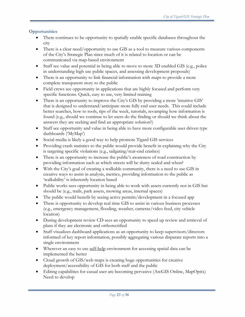
Opportunities • There continues to be opportunity to spatially enable specific databases throughout the
city • There is a clear need/opportunity to use GIS as a tool to measure various components
of the City’s Strategic Plan since much of it is related to location or can be communicated via map-based environment
• Staff see value and potential in being able to move to more 3D enabled GIS (e.g., police in understanding high use public spaces, and assessing development proposals)
• There is an opportunity to link financial information with maps to provide a more complete transparent story to the public
• Field crews see opportunity in applications that are highly focused and perform very specific functions. Quick, easy to use, very limited training
• There is an opportunity to improve the City’s GIS by providing a more ‘intuitive GIS’ that is designed to understand/anticipate more fully end user needs. This could include better searches, how to tools, tips of the week, tutorials, revamping how information is found (e.g., should we continue to let users do the finding or should we think about the answers they are seeking and find an appropriate solution?)
• Staff see opportunity and value in being able to have more configurable user driven type dashboards (‘MyMap’)
• Social media is likely a good way to help promote Tigard GIS services • Providing crash statistics to the public would provide benefit in explaining why the City
is targeting specific violations (e.g., tailgating/rear-end crashes) • There is an opportunity to increase the public’s awareness of road construction by
providing information such as which streets will be slurry sealed and when? • With the City’s goal of creating a walkable community, there is a need to use GIS in
creative ways to assist in analysis, metrics, providing information to the public as ‘walkability’ is inherently location based
• Public works sees opportunity in being able to work with assets currently not in GIS but should be (e.g., trails, park assets, mowing areas, internal spaces)
• The public would benefit by seeing active permits/development in a focused app • There is opportunity to develop real time GIS to assist in various business processes
(e.g., emergency management, flooding, weather, cameras/video feed, city vehicle location)
• During development review CD sees an opportunity to speed up review and retrieval of plans if they are electronic and orthorectified
• Staff visualizes dashboard applications as an opportunity to keep supervisors/directors informed of key report information, possibly aggregating various disparate reports into a single environment
• Wherever an easy to use self-help environment for accessing spatial data can be implemented the better
• Cloud growth of GIS/web maps is creating huge opportunities for creative deployment/accessibility of GIS for both staff and the public
• Editing capabilities for casual user are becoming pervasive (ArcGIS Online, MapOptix) Need to develop
City of Tigard GIS Strategic Plan
Page 24 of 36
• Abundant vendor supplied templates available, need to explore feasibility and take advantage of development time-savings
• Need to capitalize further on GIG resources and partnerships (Metro/State) (For example, data sharing, pushing for more map services)
• The Economic Development Manager sees opportunity in being able to perform better and more intelligent analysis and make better decisions with GIS data supporting City initiatives pertaining to the economic development opportunities in primarily the Industrial/Manufacturing 'trade sector'. This includes demographic data, business/employment data, assessor data (including historical data, and data which includes land, structure, equipment), buildable lands
• The Economic Development Manager sees opportunity in initiatives with GIS analysis and tools that focus on and support a ‘business friendly’ Tigard
Threats
• It is easy to fall into the trap of “eyes being bigger than the stomach.” Keeping track of the business need or value to the public at all time is essential
• There has been a trend of diminishing GIS staff resources affecting timely delivery of GIS services and maintenance of GIS data
• Limited resources for research and development. GIS staff has the institutional knowledge to best understand how GIS technology is evolving; however, the need to commit time to staying abreast of emerging trends and new technologies is not well established. It is critical that this piece become more of a core component of the program
• The GIS professional services budget has been reduced over time, much due to business decisions. It is important to keep in mind that specialized professional GIS services are still likely to be needed in the future
• Pressure to support multiple GIS platforms of different business systems
City of Tigard GIS Strategic Plan
Page 25 of 36
Analysis of Interviews –Major Issues This section analyzes the collection of themes collected during the SWOT analysis and aggregates them into the most salient issues affecting GIS followed by recommended actions. These recommended actions further translate into objectives of the plan. The issues are organized in the following categories:
• Application Related • GIS Program Related • Business Needs Related • Policy Related
Application Related Accessibility/Awareness of Data While there has been a very successful effort to build up the GIS layers composing Tigard’s GIS, the amount of GIS layers has reached a point where many people are not aware of what’s available to them, even if it is only a few clicks away in one of the applications available. There appears to be both an awareness and accessibility issue with our GIS data. Additionally, some data has many uses yet there is a lack of understanding of what the data can do, thus the data is not fully optimized. For example, the City has survey grade Lidar. While some of the data has been pulled into GIS and products derived, there is significant potential to use the point cloud data both in GIS and preliminary survey. Recommendations:
• Research how end users look up GIS related information and evaluate how this can be applied to improve content management of GIS
• Set an objective to improve accessibility and awareness of the GIS data contained within the City’s GIS. This can extend to improving applications for finding data, searching capabilities, training, etc.
Performance/Functionality of Map Applications -Meeting User Needs It was clear from the SWOT analysis that despite much progress on building applications to meet user needs there is still much work to be done. As expected, needs change over time. Additionally, expectation levels rise and users transition from one application to another and see potential improvements and observe gaps or lack of functionality in the current set of map tools available to them. Some of these main issues/improvements/needs include:
• Overall intuitiveness of map usability needs to be improved. Casual users need applications that require little or no training
City of Tigard GIS Strategic Plan
Page 26 of 36
• Simplicity and ease of use of GIS in field applications is essential • Understanding the vast amount of layers and finding out if layers are available is
cumbersome • Some workflows are complex, very dynamic, and require quick turnaround times. The
current set of tools still does not fully cover all needs (e.g., Police Intel briefings). More flexible or finely tuned GIS solutions are needed
• The external GIS web page (and accompanying applications) need to accommodate multiple platform devices and incorporate social media as integral part of the design
• Incorporate cloud computing as a means to extend the City’s GIS • Extending editing capabilities to a wider audience • Extending analytical (Geoprocessing tools) to a wider audience
Recommendations:
• Make an objective to target user requests related to improving intuitiveness of Tigard Maps, field applications, editing capabilities, way-finding/searching for layers, and the external web page
• Make it an objective to incorporate cloud computing (ArcGIS Online ecosystem) as well as analytical tools as a means to extending the City’s GIS
• Identify which business process need special focused applications. Prioritize and implement solutions to meet those needs
GIS Program Related Delay Time in Project Completion There has been a delay in project completion time due to the increasing demand for GIS-based solutions in the organization combined with fluctuations in GIS staffing. In addition, shifts in the power user group has resulted in the GIS Section assuming more mapping and analysis functions which occurred without an objective look at resource availability. Recommendations:
• Set an objective to Research URISA GIS Management Institute GIS Capability Maturity to develop a solid business case for geospatial staffing to meet city GIS needs by identifying necessary critical work functions needed to maintain an enterprise GIS
• Establish a new model of GIS program governance to ensure adequate use of enterprise GIS program resources. Establish a senior level GIS committee to review high level GIS programmatic issues, resources, and projects. Establish a secondary committee to coordinate on technical issues, specific application and data issues
• On an annual basis review the GIS Layer Stewardship Agreements with departments to ensure data layers have maintenance resources identified
Graphic courtesy PCC
City of Tigard GIS Strategic Plan
Page 27 of 36
Data Standards not fully Developed GIS data standards remain loosely defined within the City. While attempts to ‘piggyback’ on standards used by the region have been somewhat satisfactory, there needs to be more of an explicit effort to have them formalized at the City. For example, the City needs to have its own GIS data standards to supply consultants who perform GIS data work as well as codify relevant portions of the City’s code to ensure GIS data standards are institutionalized. Recommendations:
• Set an objective to complete GIS Data Standards for the organization and have the standards institutionalized/codified where applicable
• Coordinate with regional GIS data standards development in order to ensure consistency amongst agencies
Power User Group and GIS Staffing Since approximately 2010, the GIS ‘power user group’ i.e., staff with a background in GIS or those who have been trained in geospatial sciences, has decreased. This has occurred primarily in Community Development, Police, and Engineering. While the overall push of the enterprise GIS has been to empower casual users to utilize GIS applications with little training, there is still a demand for analysis involving desktop GIS applications and a strong understanding of spatial concepts, especially in regards to data maintenance and ad-hoc mapping and analysis. To some extent data editing can, and is being decentralized to casual users through easy to use focused applications, but in the arena of ad-hoc mapping and analysis there remains a gap. In an attempt to fill the void, GIS Section staff provides support where it can, however, increasingly; timely response is becoming difficult due to increasing demand for GIS resources and an existing backlog of requests and projects. Recommendations:
• Set an objective to Research URISA GIS Management Institute GIS Capability Maturity Model to develop a solid business case for geospatial trained staff to meet city GIS needs by identifying necessary critical work functions needed to maintain an enterprise GIS
• Work with departments to ensure outcomes of the geospatial staffing needs identified are incorporate these needs into a plan to improve department GIS support at the department level
• Coordinate with departments to ensure positions requiring geospatial knowledge or related technical skills are incorporated into job descriptions
Professional Services Budget Reduced The utilization of professional services has been instrumental in the development of the City’s enterprise GIS, as well as for specific integration and application projects requiring specialized expertise. In addition, professional services assist as a release valve for high resource demand situations to complete projects in a timely manner. During cost cutting measures to reduce the GIS budget, the professional services budget was reduced to a zero dollar amount, leaving only outside technical support paid through software
City of Tigard GIS Strategic Plan
Page 28 of 36
subscriptions as the only venue for additional expertise. This has been in effect for one fiscal year. To some extent, GIS Section staff have been able to stave off the need for outside professional service due to its expanding knowledge base in different technical areas (e.g., programming, database design), however it is likely with some of the newer technologies that departments are requesting to be implemented (e.g., real time/geoevent processing), it is likely that at some point professional service will be needed. Recommendations:
• Ensure GIS professional service budgets are built on solid business cases and tied to department work plans and/or enterprise GIS initiatives
• Coordinate with the GIG to develop means to share knowledge/expertise either through partnerships or collaborating on common projects and technical issues
Pressure to Support Multiple Business System GIS Modules Many business systems that have location based information are increasingly offering mapping components/modules along with their core product. The range of mapping solutions is as diverse as the different applications themselves. Supporting multiple mapping solutions becomes a resource issue for GIS Section staff. Having multiple mapping modules compounds maintenance and support. In addition, when end users have multiple mapping environments to use, without some standardization, they face navigation and familiarity issues with the applications which can impact performance and levels of use. Recommendations:
• Develop GIS standards that contain information for departments to use when new software applications are being procured that involve a mapping component or when integration with GIS is required
• Coordinate with procurement staff to ensure appropriate RFPs use language in support of GIS standards
• Obtain senior management support of GIS standards related to procurement of business systems and other purchased services involving map based solutions
Business Needs Related Economic Development Initiatives Need Greater Level of Business Intelligence/Analysis The City of Tigard’s Strategic Plan contains a goal to ‘ensure development advances the vision’. This goal places new emphasis on the importance of a healthy business climate and the city working closely with the community on advancing opportunities on underdeveloped and undeveloped land. To that end, GIS has an additional supportive role in assisting staff on economic development issues by providing improved levels of business intelligence and analysis.
City of Tigard GIS Strategic Plan
Page 29 of 36
Recommendations:
• Ensure that city strategic plan economic development objectives are woven into the GIS strategic plan objectives
• Coordinate with Economic Development Manager to identify GIS related needs of the business community are incorporated into annual GIS needs assessment
Solutions for Specialized Police Workflows Involving Location-based Information and Business Data The SWOT sessions identified specific workflows related to police reporting. These include crime analysis, police briefings (Intel Briefings), and support to operations. In general, these police related GIS needs involve developing focused application solutions and streamlining workflows. Essentially, applications would need a minimal amount of buttons and operations to get the information quickly due to the immediacy surrounding the police operations. In addition, Intel briefings need to grab specific content from various data sources and present in report format. Current production time of these presentations is tedious and needs to contain more automation where applicable in order to reduce staff preparation time. Recommendation:
• Set an objective to create an Applications Strategy and include the development of solutions addressing streamlining Police briefings workflows and other responsive application solutions supporting Police operations
Consolidated ‘Real Time’ Business Data Needed Within Map-Based Environment ‘Operations Dashboard’ Mentioned during the SWOT work sessions was the need to provide more summarized real time content of GIS data. With city GIS data coming into maturity and becoming more integrated with business data, and with the advent of dashboard-based applications it is now possible to use the GIS to display information in real time or near real time including metric based or ‘gauges’ displaying rolled up content KPIs (key performance indicators) or trends. The development of these types of applications will have multiple benefits. Not only will they save staff time automating and consolidating summary report information, the information will be available to supervisors, senior management, and where applicable the public. They also have the benefit of providing a ‘one-stop shopping’ experience for information. In other words instead of using individual business system dashboards, which vary by vendor, a single uniform design can be applied using GIS-based tools to provide a predictable and easy to navigate environment for the layperson. Recommendation:
• Establish and implement GIS Technology Strategy to systematically evolve into new or emerging technologies, including real time solutions and dashboard-based solutions
City of Tigard GIS Strategic Plan
Page 30 of 36
• Set an objective to create Applications Strategy and include the development of real time and dashboard solutions
Social Media’s Role in further extending/facilitating/enabling GIS in the community As mentioned above in Trends Impacting GIS Social media platforms, such as Facebook and Twitter, have revolutionized the ways governments communicate with the public. GIS is social media in itself as it offers the ability for the general public to communicate via maps (e.g., information exchange, constructive dialogs, mash-ups, social issues). GIS as social media is a fundamental paradigm shift. The active dialog/open environment of mapping via the web has significant implications in terms of a two-way communication medium for Tigard and the public. Recommendations:
• Research how other agencies are utilizing GIS with social media venues; • Actively incorporate social media considerations into applicable GIS projects • Utilize the ‘citizens as sensors’ concept when soliciting the public’s input/comments
related to city projects/programs • Design social media into GIS web pages to help promote web maps/apps and provide
training (e.g., YouTube)
3D Capability in GIS Needed An enhanced 3D capability in both visualization and analysis is needed by departments to support business activities. For example, in development review during the permitting process and in police tactical exercises in planning for events, such as high use public spaces. 3D mapping represent the next generation of GIS. Better visualization and comprehension, faster web applications, and improving availability of data that can be used in a 3D environment point to a stronger presence of 3D GIS in near future. Recommendations:
• Establish and implement GIS Technology Strategy to systematically evolve into new or emerging technologies, including 3D based solutions
Integration with Other Business Systems Still Needed, Including Real Time Over the last five years substantial progress has been made integrating GIS with business systems, linking tabular data to features in GIS. Most of the major business systems have some degree of integration with GIS. The most common integration form has been database extracts which are then stored in a separate database and accessed by GIS. More direct business system integration has slowly been pursued during conversion or upgrade projects (such as with the work order system in Public Works). Integration is also now involving bidirectional movement between applications. For example, from the new work order system, GIS features can be selected and passed off to the work order application for the immediate creation of a work
City of Tigard GIS Strategic Plan
Page 31 of 36
order. Such types of integration tend to be complex, but greatly streamline functionality for end-users. Recommendations:
• Develop a GIS Integration Strategy to help with identifying and prioritizing integration initiatives with GIS and other business systems. Align this strategy with future business system upgrades/overhauls
Policy Related City’s Strategic Plan Will Require Creative/Closely Integrated GIS based Decision Support Tools As City Council’s strategic plan begins implementation, GIS must be at the ready with the data and analytical tools and skills to develop the right information to help staff, the public, and City Council make the most informed decisions. Currently various analytical methods needed for assessing/measuring walkability within the City are not fully developed, such as routing (network analysis) and need development. Additionally, the data needs of a city focusing on walkability will mean a more fine-grained mapping base than is currently available. For example, much of the pedestrian environment remains tied to street data and can only be displayed diagrammatically. The pedestrian experience requires a richer more detailed mapping environment. Furthermore, resources (e.g., staff trained in geospatial sciences) will be needed in order to be able to conduct specialized GIS analysis associated with the City’s Strategic Plan. Recommendations:
• Align GIS Strategic Plan and subsequent GIS Implementation Plan with City Strategic Plan goals and objectives
• Identify needed resources, such as software, analytical tools, data, and staff training to meet required strategic plan needs. Incorporate these needs to appropriate strategies (e.g., Data Acquisition Strategy)
City of Tigard GIS Strategic Plan
Page 32 of 36
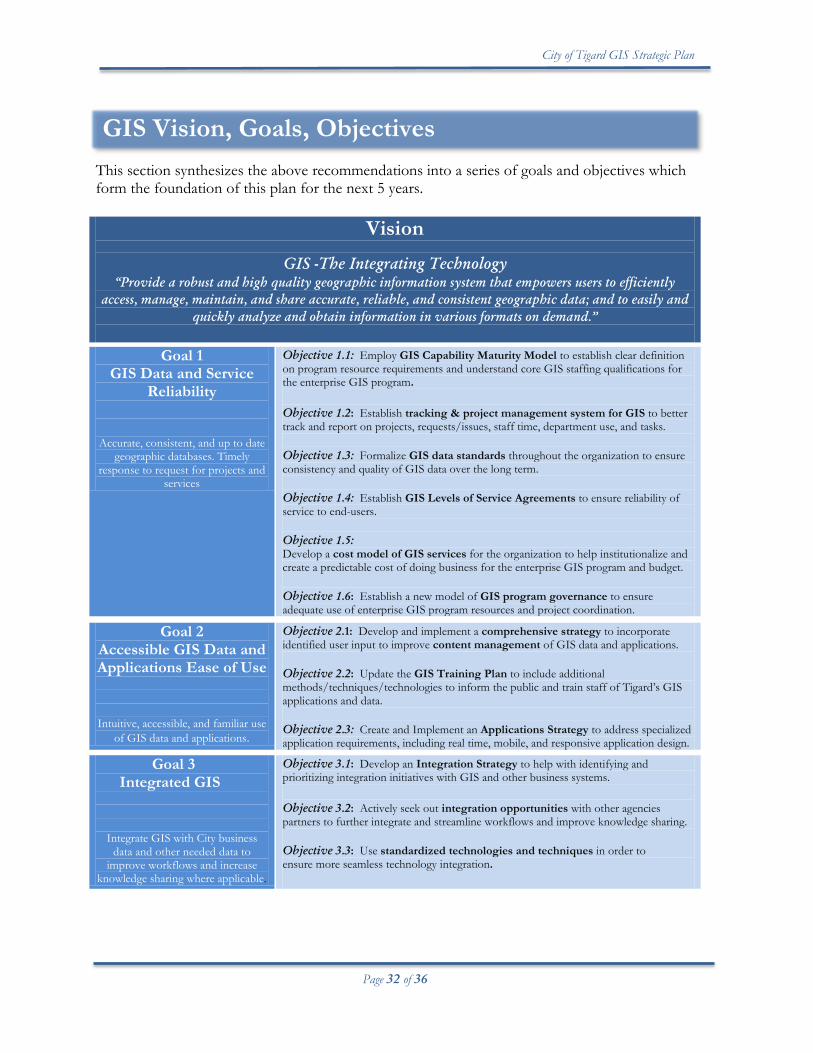
GIS Vision, Goals, Objectives This section synthesizes the above recommendations into a series of goals and objectives which form the foundation of this plan for the next 5 years.
Vision
GIS -The Integrating Technology “Provide a robust and high quality geographic information system that empowers users to efficiently
access, manage, maintain, and share accurate, reliable, and consistent geographic data; and to easily and quickly analyze and obtain information in various formats on demand.”
Goal 1
GIS Data and Service Reliability
Accurate, consistent, and up to date geographic databases. Timely
response to request for projects and services
Objective 1.1: Employ GIS Capability Maturity Model to establish clear definition on program resource requirements and understand core GIS staffing qualifications for the enterprise GIS program. Objective 1.2: Establish tracking & project management system for GIS to better track and report on projects, requests/issues, staff time, department use, and tasks. Objective 1.3: Formalize GIS data standards throughout the organization to ensure consistency and quality of GIS data over the long term. Objective 1.4: Establish GIS Levels of Service Agreements to ensure reliability of service to end-users. Objective 1.5: Develop a cost model of GIS services for the organization to help institutionalize and create a predictable cost of doing business for the enterprise GIS program and budget. Objective 1.6: Establish a new model of GIS program governance to ensure adequate use of enterprise GIS program resources and project coordination.
Goal 2 Accessible GIS Data and Applications Ease of Use
Intuitive, accessible, and familiar use of GIS data and applications.
Objective 2.1: Develop and implement a comprehensive strategy to incorporate identified user input to improve content management of GIS data and applications. Objective 2.2: Update the GIS Training Plan to include additional methods/techniques/technologies to inform the public and train staff of Tigard’s GIS applications and data. Objective 2.3: Create and Implement an Applications Strategy to address specialized application requirements, including real time, mobile, and responsive application design.
Goal 3 Integrated GIS
Integrate GIS with City business data and other needed data to
improve workflows and increase knowledge sharing where applicable.
Objective 3.1: Develop an Integration Strategy to help with identifying and prioritizing integration initiatives with GIS and other business systems. Objective 3.2: Actively seek out integration opportunities with other agencies partners to further integrate and streamline workflows and improve knowledge sharing. Objective 3.3: Use standardized technologies and techniques in order to ensure more seamless technology integration.
City of Tigard GIS Strategic Plan
Page 33 of 36
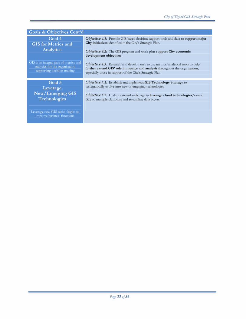
Goals & Objectives Cont’d
Goal 4 GIS for Metrics and
Analytics
GIS is an integral part of metrics and
analytics for the organization supporting decision-making
Objective 4.1: Provide GIS based decision support tools and data to support major City initiatives identified in the City’s Strategic Plan. Objective 4.2: The GIS program and work plan support City economic development objectives.
Objective 4.3: Research and develop easy to use metrics/analytical tools to help further extend GIS’ role in metrics and analysis throughout the organization, especially those in support of the City’s Strategic Plan.
Goal 5 Leverage
New/Emerging GIS Technologies
Leverage new GIS technologies to improve business functions
Objective 5.1: Establish and implement GIS Technology Strategy to systematically evolve into new or emerging technologies Objective 5.2: Update external web page to leverage cloud technologies/extend GIS to multiple platforms and streamline data access.
City of Tigard GIS Strategic Plan
Page 34 of 36
Appendix GIS Governance The following contains descriptions of the two groups that will represent the governance structure as identified in the Plan. GIS Executive Committee (GISEC) The purpose of the GISEC is to encourage and guide the effective utilization of city GIS technology and to ensure city departments coordinate the efficient use of GIS resources related to GIS projects and GIS data management. The GISEC serves as an advocacy group, promoting collaboration amongst departments related to GIS data and GIS related issues. GISEC members are champions of the City’s enterprise GIS having a strong understanding of its benefits and the importance of coordinating amongst departments and partner agencies. GISEC members are a stabilizing force in seeing the big picture long term interests of the city’s GIS program. The GISEC will look to the GIS Strategic Plan and GIS Work Plan in regards to input, feedback, issues, and decision-making related to the GIS program. The GISEC will depend on the GIS Section in the IT Division as the major implementing force behind the GIS Strategic Plan and ensure the GISEC is informed about progress and alerted to issues. The GISEC also provides feedback/decision-making/recommendations related to GIS policy affecting the City’s interests.
The GISEC generally meets quarterly to coordinate GIS related projects, review the GIS Work Plan, address GIS policy and or GIS data issues and coordinate timing/priority of major department GIS projects. The GIS Coordinator leads the GISEC meetings and is responsible for setting up meetings, reporting, and general administrative duties.
The GISEC is composed of department directors or assistant directors that have a key stake in the City’s enterprise GIS. This includes:
• Community Development • Public Works • Police • Finance and Information Services • Others representatives as appointed by the City Manager
Specific areas of focus of the GISEC include: • Large scale GIS project coordination/prioritization • Policy issues related to GIS and the city. Examples include:
o Data Stewardship Agreement
City of Tigard GIS Strategic Plan
Page 35 of 36
o Input on GIS data acquisition initiatives, specifically those that impact multiple departments
o GIS standards/enterprise GIS data issues
GIS Technical Committee (GISTC) The purpose of the GIS Technical Committee (GISTC) is to coordinate GIS technical issues and configurations of the City’s enterprise GIS applications. GISTC members are generally ‘power’ users of GIS applications, maintain GIS data and/or work closely with their department’s business data integrated with GIS. With their technical knowledge of GIS, GISTC members are able to provide feedback and coordinate with the GIS Section on specific issues affecting their departments. Where there are potentially technical issues that will involve the eventual decision-making of the GISEC, the GISTC may be tasked with initial recommendations. The group generally meets quarterly and serves as a forum to coordinate technical issues and information sharing. Specific functions of this committee include:
• Coordination of GIS technical issues (applications, GIS data) • Information sharing • Data model review • GIS data maintenance issues • Liaison to department application use and needs • Advocacy of the use and benefits of an enterprise GIS
Department directors appoint members of the GIS Technical Committee. Coordination between the GISEC and GISTC As the GISEC and GISTC have different roles and have different members, there will need to be adequate coordination and communication between the two committees to avoid duplication of efforts and that the appropriate committee is addressing the right issue. For example, the GISTC has a heavy focus on technical issues, whereas the GISEC is more focused on city-wide long term issues. Each will rely on the other for information. The GIS Coordinator will be the primary liaison between the groups to facilitate communication and ensure issues are channeled appropriately.
City of Tigard GIS Strategic Plan
Page 36 of 36
References i Urban and Regional Information Systems Association (URLIS), GIS Management Institute, 2013. ii Heggestuen, John, Business Insider, One in Every 5 People in the World Own A Smartphone, One in Every 17 own A Tablet, December, 2013. iii Dignan, Larry, ZDNet, Tables or smartphones: Which is the future for business?, August 2013.
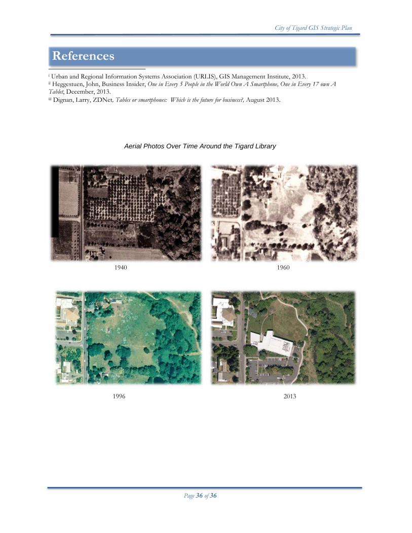
Aerial Photos Over Time Around the Tigard Library 1940 1960 1996 2013