gis/eam solution for companies type vak
TRANSCRIPT
GIS/EAM Solution for Companies Type VaK
- 2 -
1 Introduction
1.1 References
The presented set of components is used for operation of many companies type VaK (Water Supply and Sanitation) for more than twelve years. Throughout it is fully supported. According to customer needs are also being developed auxiliary modules, such as data export for calculation of pressure condition in the network, bulk import of camera survey of sewage system and more.
1.2 Components
1.2.1 GS Technology
The current geographic information systems (GIS) technology can be characterized by two basic attributes – processing of geographic data by standard relational database technology and implementation of Web resources for planar data dissemination and use of these data. The GIS technology architecture is formed by means of the GEOVAP, Ltd. Company.
1.2.2 Data Model GISVaK
The data model represents all necessary objects in a relational database. The data model exists for ORACLE and Microsoft SQL Server platforms. The further mentioned software allows also use of other relational databases (such as MySQL and PostgreSQL), for which is possible to prepare the data model.
1.2.3 Strong Client - GeoStoreV6®
It is a desktop GIS and graphic editor – professional GIS/CAD software, which is being constantly developed and in addition is also being provided technical support. This software is mainly used for acquisition and maintenance of data. Key reference: the number of used licenses is higher than 600.
1.2.4 Marushka® and MarushkaDesign
It is a web map server – box software, which is being constantly developed and in addition the technical support is also being provided. It is used especially for consumption of GIS services: data presentation and data mining. Key references: ISKN on CUZK
1.2.5 Breakdown Service
This is the web software for monitoring and recording of breakdowns. It is a single web-based environment for data acquisition and mining. The collected data allow network fault analyzes and evaluating the costs of troubleshooting by territorial units.
1.2.6 Approval Service
It is a complementary pair of web SW for receipt of requests for approval, generating of approvals and list of approvals. The first SW is collecting place, the second SW provides preparation and processing of approval by manager/owner of the technical infrastructure.
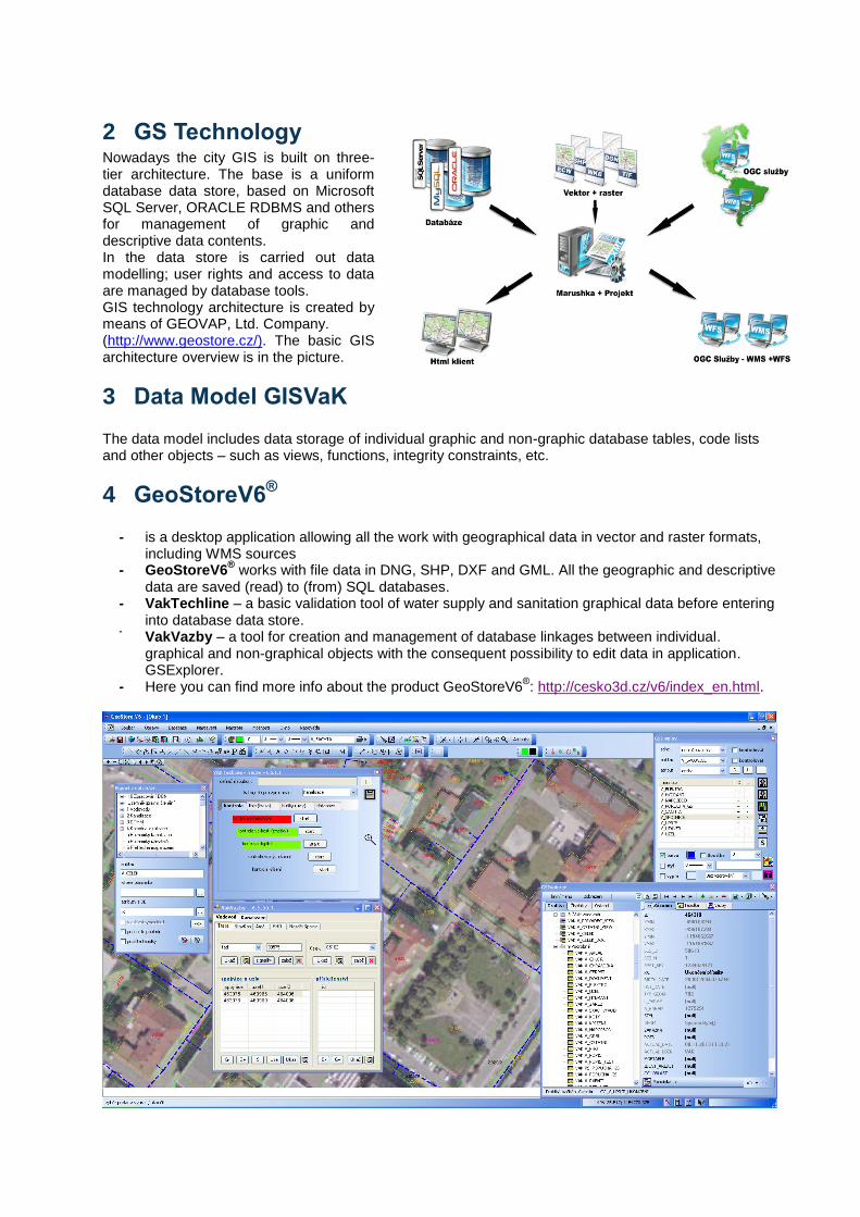
2 GS Technology Nowadays the city GIS is built on three-tier architecture. The base is a uniform database data store, based on Microsoft SQL Server, ORACLE RDBMS and others for management of graphic and descriptive data contents. In the data store is carried out data modelling; user rights and access to data are managed by database tools. GIS technology architecture is created by means of GEOVAP, Ltd. Company. (http://www.geostore.cz/). The basic GIS architecture overview is in the picture.
3 Data Model GISVaK The data model includes data storage of individual graphic and non-graphic database tables, code lists and other objects – such as views, functions, integrity constraints, etc.
4 GeoStoreV6®
- is a desktop application allowing all the work with geographical data in vector and raster formats,
including WMS sources - GeoStoreV6
® works with file data in DNG, SHP, DXF and GML. All the geographic and descriptive
data are saved (read) to (from) SQL databases. - VakTechline – a basic validation tool of water supply and sanitation graphical data before entering
into database data store. - VakVazby – a tool for creation and management of database linkages between individual.
graphical and non-graphical objects with the consequent possibility to edit data in application. GSExplorer.
- Here you can find more info about the product GeoStoreV6®: http://cesko3d.cz/v6/index_en.html.
- 4 -
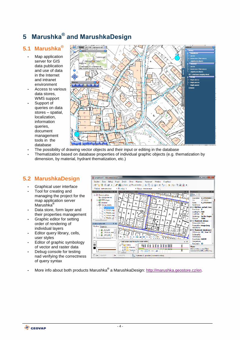
5 Marushka® and MarushkaDesign
5.1 Marushka®
- Map application server for GIS data publication and use of data in the Internet and intranet environment
- Access to various data stores, WMS support
- Support of queries on data stores – spatial, localization, information queries, document management tools in the database
- The possibility of drawing vector objects and their input or editing in the database - Thematization based on database properties of individual graphic objects (e.g. thematization by
dimension, by material, hydrant thematization, etc.)
5.2 MarushkaDesign
- Graphical user interface - Tool for creating and
managing the project for the map application server Marushka
®
- Data store, form layer and their properties management
- Graphic editor for setting order of rendering of individual layers
- Editor query library, cells, user styles
- Editor of graphic symbology of vector and raster data
- Debug console for testing nad verifying the correctness of query syntax
- More info about both products Marushka® a MarushkaDesign: http://marushka.geostore.cz/en.
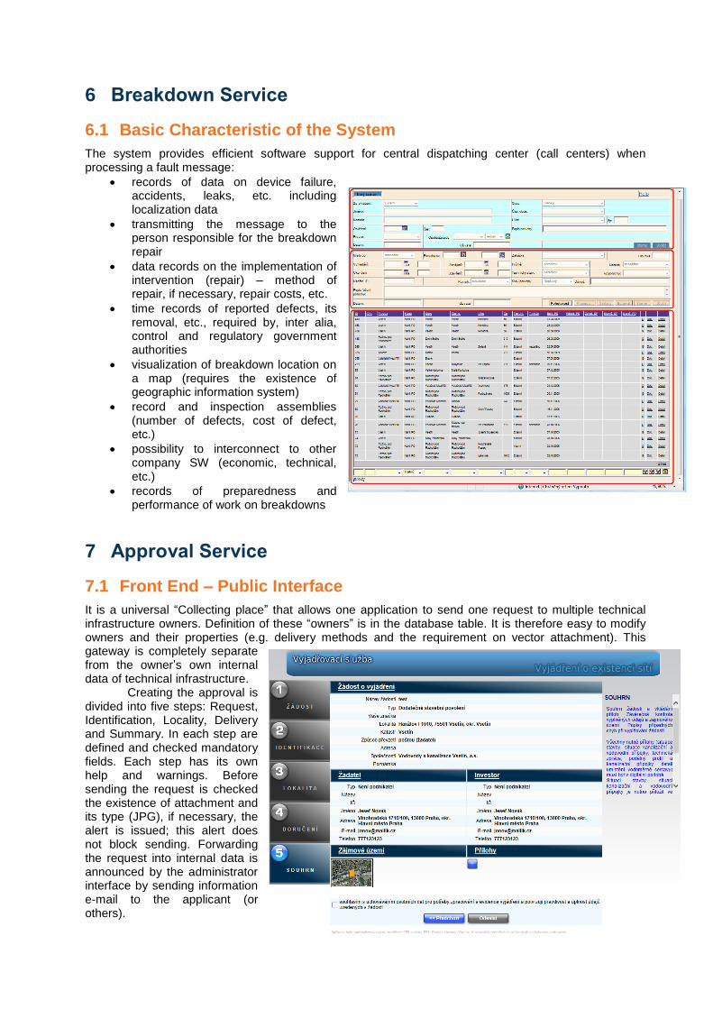
6 Breakdown Service
6.1 Basic Characteristic of the System
The system provides efficient software support for central dispatching center (call centers) when processing a fault message:
records of data on device failure, accidents, leaks, etc. including localization data
transmitting the message to the person responsible for the breakdown repair
data records on the implementation of intervention (repair) – method of repair, if necessary, repair costs, etc.
time records of reported defects, its removal, etc., required by, inter alia, control and regulatory government authorities
visualization of breakdown location on a map (requires the existence of geographic information system)
record and inspection assemblies (number of defects, cost of defect, etc.)
possibility to interconnect to other company SW (economic, technical, etc.)
records of preparedness and performance of work on breakdowns
7 Approval Service
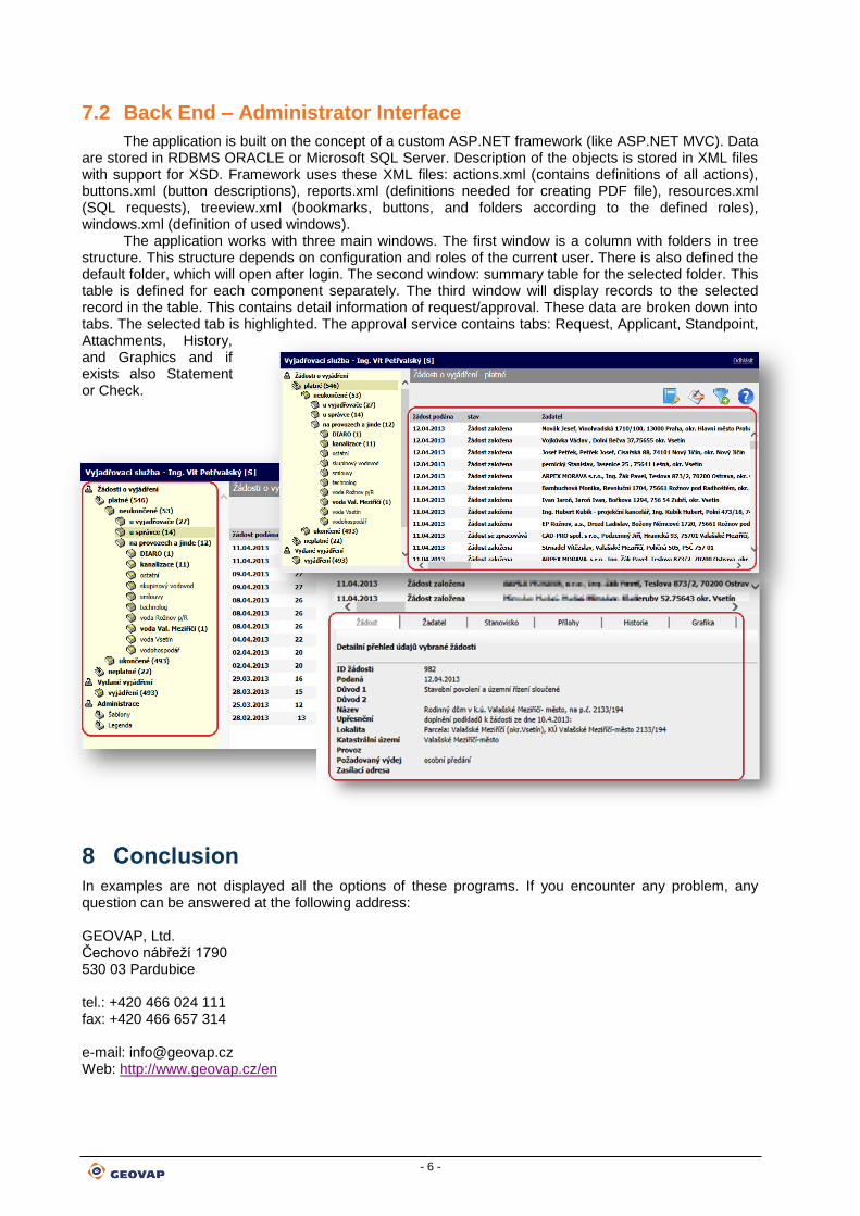
7.1 Front End – Public Interface
It is a universal “Collecting place” that allows one application to send one request to multiple technical infrastructure owners. Definition of these “owners” is in the database table. It is therefore easy to modify owners and their properties (e.g. delivery methods and the requirement on vector attachment). This gateway is completely separate from the owner’s own internal data of technical infrastructure. Creating the approval is divided into five steps: Request, Identification, Locality, Delivery and Summary. In each step are defined and checked mandatory fields. Each step has its own help and warnings. Before sending the request is checked the existence of attachment and its type (JPG), if necessary, the alert is issued; this alert does not block sending. Forwarding the request into internal data is announced by the administrator interface by sending information e-mail to the applicant (or others).
- 6 -
7.2 Back End – Administrator Interface
The application is built on the concept of a custom ASP.NET framework (like ASP.NET MVC). Data are stored in RDBMS ORACLE or Microsoft SQL Server. Description of the objects is stored in XML files with support for XSD. Framework uses these XML files: actions.xml (contains definitions of all actions), buttons.xml (button descriptions), reports.xml (definitions needed for creating PDF file), resources.xml (SQL requests), treeview.xml (bookmarks, buttons, and folders according to the defined roles), windows.xml (definition of used windows).
The application works with three main windows. The first window is a column with folders in tree structure. This structure depends on configuration and roles of the current user. There is also defined the default folder, which will open after login. The second window: summary table for the selected folder. This table is defined for each component separately. The third window will display records to the selected record in the table. This contains detail information of request/approval. These data are broken down into tabs. The selected tab is highlighted. The approval service contains tabs: Request, Applicant, Standpoint, Attachments, History, and Graphics and if exists also Statement or Check.
8 Conclusion
In examples are not displayed all the options of these programs. If you encounter any problem, any question can be answered at the following address: GEOVAP, Ltd. Čechovo nábřeží 1790 530 03 Pardubice tel.: +420 466 024 111 fax: +420 466 657 314 e-mail: [email protected] Web: http://www.geovap.cz/en