global climates and biomes - apes -...
TRANSCRIPT
CHAPTER
4 Global Climates and Biomes
[Notes/Highlighting]
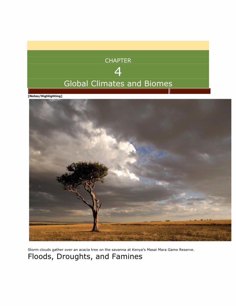
Storm clouds gather over an acacia tree on the savanna at Kenya’s Masai Mara Game Reserve.
Floods, Droughts, and Famines
I n April 2003, heavy rains began to fall along the equator in western Kenya, flooding
villages, roads, and bridges. More than 70 people died,and hundreds of thousands more
had to abandon their homes. In Nairobi, the capital of Kenya, mudslides damaged
water pipes that led from a reservoir to a water treatment plant, and more than a
million people were affected by the resulting disruption of water supplies. In many parts
of the country, displaced flood victims had no clothing, food, or drinkable water.The
danger of waterborne diseases such as cholera increased throughout the
region. Normally, rainfall in this region of East Africa ends by June and is followed by 3
months of relative dryness. In 2003, however, the rains continued throughout
June, July, and August. Widespread flooding gave the exhausted inhabitants neither
relief nor the opportunity to begin rebuilding their lives.
The Kenyan government confirmed that over 2.5 million people were at risk of starvation and declared the
situation a national disaster.
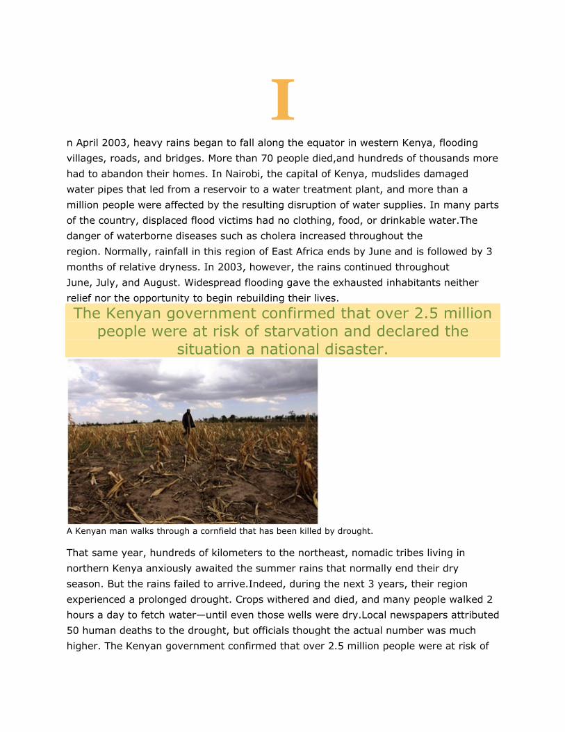
A Kenyan man walks through a cornfield that has been killed by drought.
That same year, hundreds of kilometers to the northeast, nomadic tribes living in
northern Kenya anxiously awaited the summer rains that normally end their dry
season. But the rains failed to arrive.Indeed, during the next 3 years, their region
experienced a prolonged drought. Crops withered and died, and many people walked 2
hours a day to fetch water—until even those wells were dry.Local newspapers attributed
50 human deaths to the drought, but officials thought the actual number was much
higher. The Kenyan government confirmed that over 2.5 million people were at risk of
starvation and declared the situation a national disaster. Children were most
vulnerable. Poor nutrition and the lack of safe drinking water made them susceptible to
chronic diarrhea and dehydration. By the time the rains finally arrived in
2006,decomposing carcasses of cattle, sheep, and goats littered the landscape and
threatened the quality of the drinking water.
What caused western Kenya to suffer unusually heavy rains and floods while
northeastern Kenya was hit by a devastating drought? In other words, why didn’t
rainfall in Kenya occur in predictable patterns during this period?
Global processes drive rainfall patterns. Rainfall in the tropics is closely tied to the
seasonal position of the Sun: wherever the Sun strikes Earth most directly, water
evaporates and forms clouds that drop heavy rains. The Sun passes directly over the
equator around March 21 on its way north and again around September 22 on its way
south. Because Kenya is located at the equator, there is typically heavy rainfall during
April and May. As the rain clouds continue to move north with the Sun, they drop
additional rain on northeastern Kenya. But in April 2003, for reasons that are not fully
understood, the rain clouds did not move northward from the
equator.Instead, precipitation persisted near the equator, causing severe flooding in
western Kenya and a drought in northeastern Kenya. In places such as Kenya that do
not have sophisticated water management systems,unanticipated climatic events can
have especially devastating consequences.
Sources: H. Kadomura, Climate anomalies and extreme events in Africa in 2003, including heavy rains and floods that
occurred during Northern Hemisphere summer,African Study Monographs Supplement 30 (2005): 165−181; A. McFerran,
Famine in Kenya: The rains have finally come, but for many it’s already too late, Independent(London), May 20, 2006.
KEY IDEAS Earth is characterized by patterns of temperature and precipitation. These patterns
arise from the circulation of air and ocean water, which is ultimately driven by unequal
heating of Earth by the Sun, the rotation of Earth, and Earth’s geographic
features. Geographic variations in temperature and precipitation have led to the
development of distinct terrestrial biomes, which are defined by their unique plant
communities,and distinct aquatic biomes, which are defined by their particular physical
conditions.
After reading this chapter you should be able to
• explain the forces that drive global circulation patterns and how those patterns
determine weather and climate.
• describe the major terrestrial biomes.
• describe the major aquatic biomes.
• 4. Global processes determine weather
1 and climate
[Notes/Highlighting]
An afternoon thunderstorm or a few dry, sunny days—when we talk about weather, we
are referring to the short-term conditions of the atmosphere in a local area. These
conditions include temperature, humidity, clouds,precipitation, wind speed, and
atmospheric pressure.
Weather happens on time scales from seconds to days. Climate, on the other hand, is
the average weather that occurs in a given region over a long period—typically over
several decades. It is not possible to predict weather more than a few days into the
future, but we can make general observations about global, regional, and even local
climate. For example, areas close to the North and South Poles are considerably colder
than those closer to the equator. Similarly, areas at high elevations are colder than
nearby sites at lower elevations. Areas near the equator typically receive tremendous
amounts of precipitation, whereas regions at latitudes around 30° N and 30° S typically
receive very little precipitation.
Regional differences in temperature and precipitation collectively help determine which
organisms can survive in each region. To understand these differences, we need to look
at the processes that affect the distribution of heat and precipitation across the
globe. These processes include unequal heating of Earth by the Sun, atmospheric
convection currents, the rotation of Earth, Earth’s orbit around the Sun on a tilted
axis, and ocean currents.Before we look at them in detail, however, we need to know
something about Earth’s atmosphere, where several of these processes take place.
.1.1 Earth’s Atmosphere
[Notes/Highlighting]
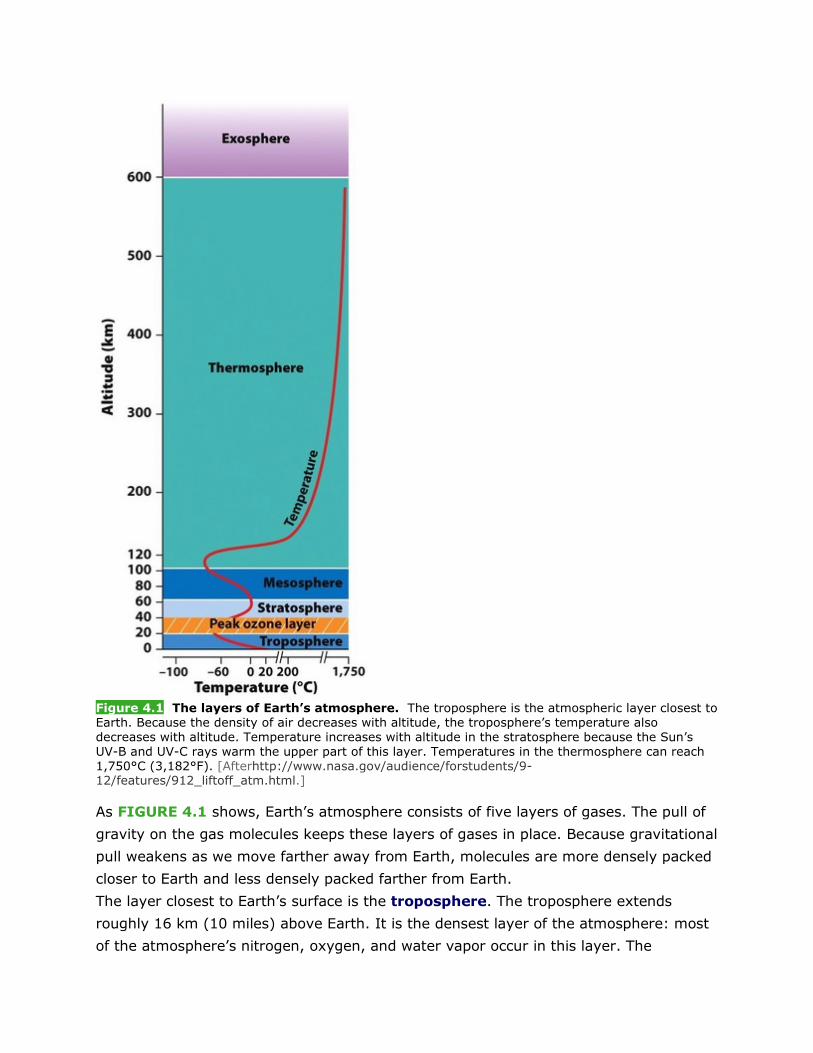
Figure 4.1 The layers of Earth’s atmosphere. The troposphere is the atmospheric layer closest to Earth. Because the density of air decreases with altitude, the troposphere’s temperature also decreases with altitude. Temperature increases with altitude in the stratosphere because the Sun’s UV-B and UV-C rays warm the upper part of this layer. Temperatures in the thermosphere can reach 1,750°C (3,182°F). [Afterhttp://www.nasa.gov/audience/forstudents/9-12/features/912_liftoff_atm.html.]
As FIGURE 4.1 shows, Earth’s atmosphere consists of five layers of gases. The pull of
gravity on the gas molecules keeps these layers of gases in place. Because gravitational
pull weakens as we move farther away from Earth, molecules are more densely packed
closer to Earth and less densely packed farther from Earth.
The layer closest to Earth’s surface is the troposphere. The troposphere extends
roughly 16 km (10 miles) above Earth. It is the densest layer of the atmosphere: most
of the atmosphere’s nitrogen, oxygen, and water vapor occur in this layer. The
troposphere is characterized by a great deal of circulation and mixing of liquids and
gases, and it is the layer where Earth’s weather occurs. Air temperature in the
troposphere decreases with distance from Earth’s surface and varies with
latitude. Temperatures can fall as low as −52°C(−62°F) near the top of the
troposphere.
Above the troposphere is the stratosphere, which extends roughly 16 to 50 km (10 to
31 miles) above Earth’s surface.Because of its greater distance from Earth’s
gravitational pull,the stratosphere is less dense than the troposphere. In the
stratosphere, because UV (ultraviolet) radiation reaches the higher altitudes first and
warms them, the higher altitudes are warmer than the lower altitudes. Ozone, a pale
blue gas composed of molecules made up of three oxygen atoms (O3),forms a layer
within the stratosphere. This ozone layer absorbs most of the Sun’s ultraviolet-B (UV-
B) radiation and all of its ultraviolet-C (UV-C) radiation. UV radiation can cause DNA
damage and cancer in organisms, so the stratospheric ozone layer provides critical
protection for our planet.Science Applied 1, “Were We Successful in Halting the
Growth of the Ozone Hole?” discusses this topic in more depth.
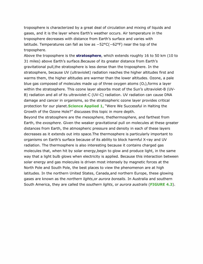
Beyond the stratosphere are the mesosphere, thethermosphere, and farthest from
Earth, the exosphere. Given the weaker gravitational pull on molecules at these greater
distances from Earth, the atmospheric pressure and density in each of these layers
decreases as it extends out into space.The thermosphere is particularly important to
organisms on Earth’s surface because of its ability to block harmful X-ray and UV
radiation. The thermosphere is also interesting because it contains charged gas
molecules that, when hit by solar energy,begin to glow and produce light, in the same
way that a light bulb glows when electricity is applied. Because this interaction between
solar energy and gas molecules is driven most intensely by magnetic forces at the
North Pole and South Pole, the best places to view the phenomenon are at high
latitudes. In the northern United States, Canada,and northern Europe, these glowing
gases are known as the northern lights,or aurora borealis. In Australia and southern
South America, they are called the southern lights, or aurora australis (FIGURE 4.2).
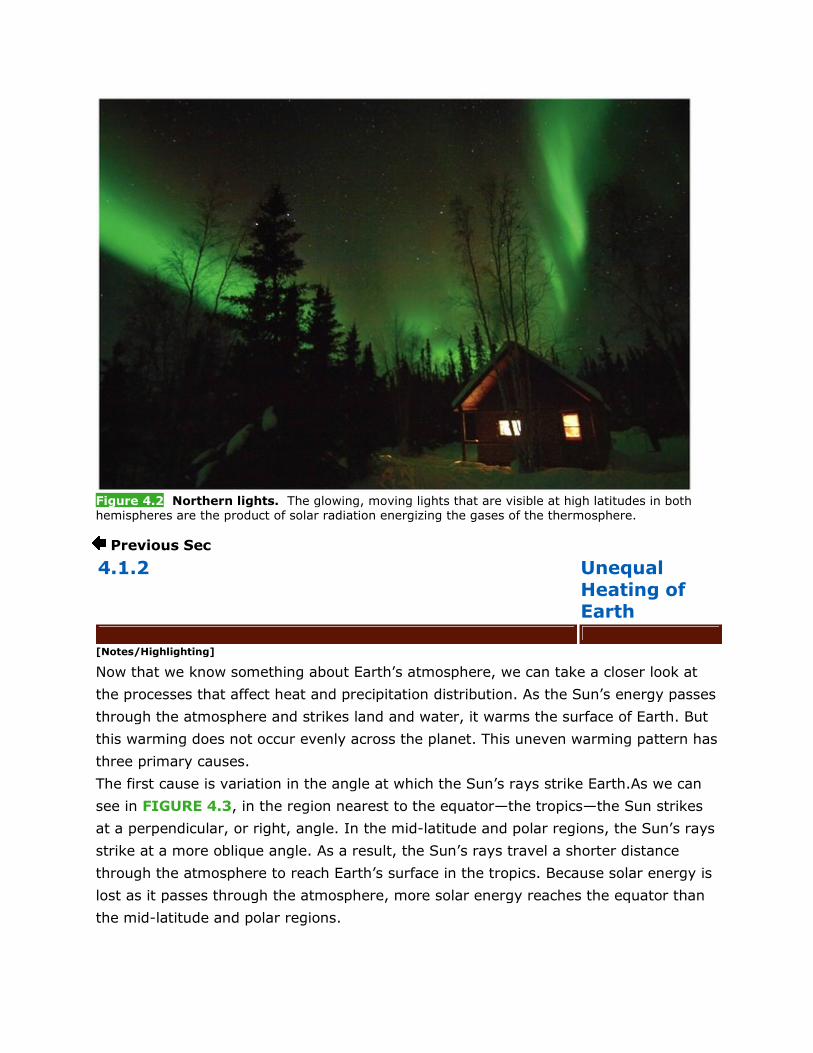
Figure 4.2 Northern lights. The glowing, moving lights that are visible at high latitudes in both hemispheres are the product of solar radiation energizing the gases of the thermosphere.
Previous Sec
4.1.2 Unequal Heating of Earth
[Notes/Highlighting]
Now that we know something about Earth’s atmosphere, we can take a closer look at
the processes that affect heat and precipitation distribution. As the Sun’s energy passes
through the atmosphere and strikes land and water, it warms the surface of Earth. But
this warming does not occur evenly across the planet. This uneven warming pattern has
three primary causes.
The first cause is variation in the angle at which the Sun’s rays strike Earth.As we can
see in FIGURE 4.3, in the region nearest to the equator—the tropics—the Sun strikes
at a perpendicular, or right, angle. In the mid-latitude and polar regions, the Sun’s rays
strike at a more oblique angle. As a result, the Sun’s rays travel a shorter distance
through the atmosphere to reach Earth’s surface in the tropics. Because solar energy is
lost as it passes through the atmosphere, more solar energy reaches the equator than
the mid-latitude and polar regions.
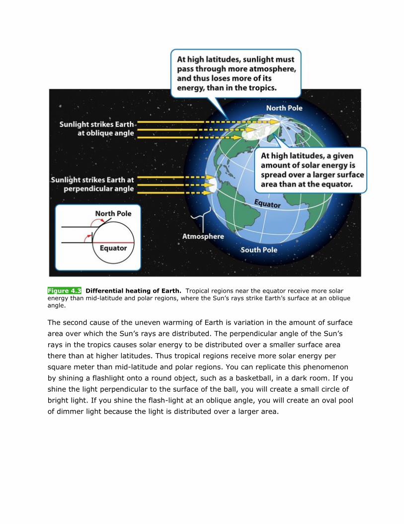
Figure 4.3 Differential heating of Earth. Tropical regions near the equator receive more solar energy than mid-latitude and polar regions, where the Sun’s rays strike Earth’s surface at an oblique angle.
The second cause of the uneven warming of Earth is variation in the amount of surface
area over which the Sun’s rays are distributed. The perpendicular angle of the Sun’s
rays in the tropics causes solar energy to be distributed over a smaller surface area
there than at higher latitudes. Thus tropical regions receive more solar energy per
square meter than mid-latitude and polar regions. You can replicate this phenomenon
by shining a flashlight onto a round object, such as a basketball, in a dark room. If you
shine the light perpendicular to the surface of the ball, you will create a small circle of
bright light. If you shine the flash-light at an oblique angle, you will create an oval pool
of dimmer light because the light is distributed over a larger area.
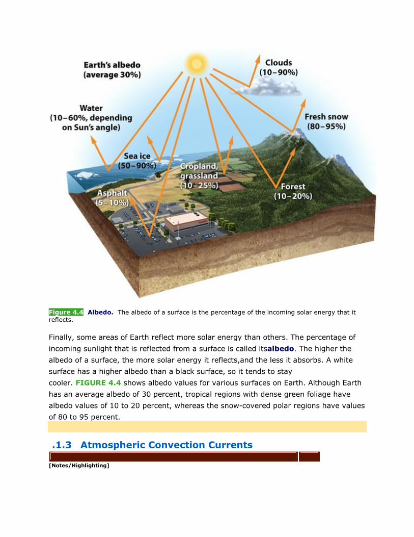
Figure 4.4 Albedo. The albedo of a surface is the percentage of the incoming solar energy that it reflects.
Finally, some areas of Earth reflect more solar energy than others. The percentage of
incoming sunlight that is reflected from a surface is called itsalbedo. The higher the
albedo of a surface, the more solar energy it reflects,and the less it absorbs. A white
surface has a higher albedo than a black surface, so it tends to stay
cooler. FIGURE 4.4 shows albedo values for various surfaces on Earth. Although Earth
has an average albedo of 30 percent, tropical regions with dense green foliage have
albedo values of 10 to 20 percent, whereas the snow-covered polar regions have values
of 80 to 95 percent.
.1.3 Atmospheric Convection Currents
[Notes/Highlighting]

Now that we have explored the reasons for the uneven heating of Earth, we will see
how that uneven heating drives the circulation of air in the
atmosphere. First, however, we will examine the properties of air that influence its
movement.
PROPERTIES OF AIR Air has four properties that determine how it circulates in the
atmosphere: density, water vapor capacity, adiabatic heating or cooling, and latent
heat release.
The density of air determines its movement: less dense air rises, whereas denser air
sinks. At a constant atmospheric pressure, warm air has a lower density than cold
air. Because of this density difference, warm air rises,whether in a room in your house
or in the atmosphere.
Figure 4.5 The saturation point of air increases with temperature. When air cools and its saturation point drops, water vapor condenses into liquid water that forms clouds. These clouds are ultimately the source of precipitation.
Warm air also has a higher capacity for water vapor than cold air. That is why, in many
parts of the world, including North America, hot summer days are associated with high
humidity: the warm air contains a lot of water vapor. The maximum amount of water
vapor that can be in the air at a given temperature is called its saturation
point.FIGURE 4.5 shows the relationship between the temperature of air and its
saturation point. When the temperature of air falls, its saturation point
decreases, water vapor condenses into liquid water, clouds form, and precipitation
occurs.
A third important property of air is its response to changes in pressure. As air rises
higher in the atmosphere, the pressure on it decreases. The lower pressure allows the
rising air to expand in volume, and this expansion lowers the temperature of the
air. This process is calledadiabatic cooling. Conversely, when air sinks toward Earth’s
surface, the pressure on it increases. The higher pressure forces the air to decrease in
volume, and this decrease raises the temperature of the air. This process is
calledadiabatic heating.
The final important property of air is the production of heat when water vapor
condenses from a gas to a liquid. As you may know, the Sun provides the energy
necessary to evaporate water on Earth’s surface and convert it into water vapor, which
enters the atmosphere. In the reverse process, when water vapor in the atmosphere
condenses into liquid water, energy is released. This phenomenon is known as latent
heat release. It is important because it means that whenever water vapor in the
atmosphere condenses, the air will become warmer, and this warm air will rise.
FORMATION OF CONVECTION CURRENTS Now that we understand the four
properties of air, we can look at the role of these properties in atmospheric
circulation. We can follow the process in FIGURE 4.6, beginning in the tropics.
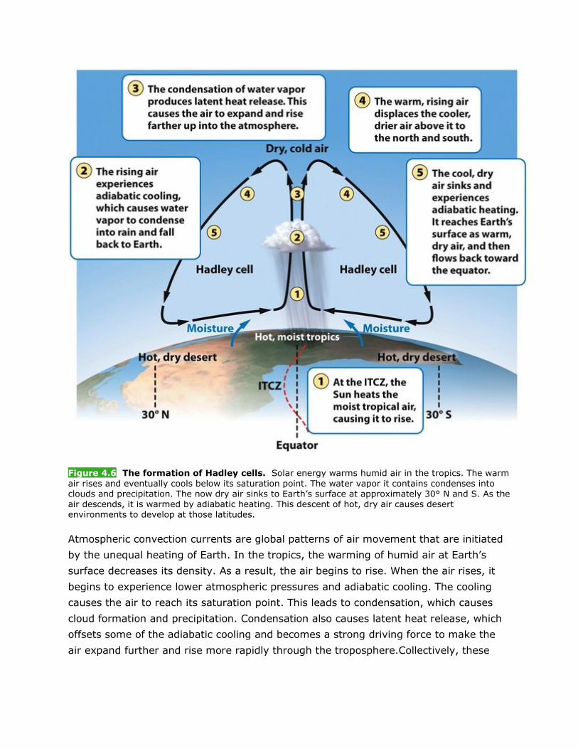
Figure 4.6 The formation of Hadley cells. Solar energy warms humid air in the tropics. The warm air rises and eventually cools below its saturation point. The water vapor it contains condenses into clouds and precipitation. The now dry air sinks to Earth’s surface at approximately 30° N and S. As the air descends, it is warmed by adiabatic heating. This descent of hot, dry air causes desert environments to develop at those latitudes.
Atmospheric convection currents are global patterns of air movement that are initiated
by the unequal heating of Earth. In the tropics, the warming of humid air at Earth’s
surface decreases its density. As a result, the air begins to rise. When the air rises, it
begins to experience lower atmospheric pressures and adiabatic cooling. The cooling
causes the air to reach its saturation point. This leads to condensation, which causes
cloud formation and precipitation. Condensation also causes latent heat release, which
offsets some of the adiabatic cooling and becomes a strong driving force to make the
air expand further and rise more rapidly through the troposphere.Collectively, these
processes cause air to rise continuously from Earth’s surface near the equator, forming
a river of air flowing upward into the troposphere.
Air near the top of the troposphere is chilled by adiabatic cooling. This air contains
relatively little water vapor. As warmer air rises from below, this cold,dry air is
displaced horizontally both north and south of the equator. This displaced air eventually
begins to sink back to Earth’s surface at approximately 30° N and S. As the air sinks, it
experiences higher atmospheric pressures, and its reduction in volume causes adiabatic
heating.By the time the air reaches Earth’s surface, it is hot and dry. As a result,regions
at 30° N and S are typically hot, dry deserts.
Much of this desert air then moves along Earth’s surface toward the equator to replace
the air that is rising there, completing the cycle. The convection currents that cycle
between the equator and 30° N and S in this way are called Hadley cells.
The area of Earth that receives the most intense sunlight, where the ascending
branches of the two Hadley cells converge, is called theintertropical convergence
zone (abbreviated ITCZ). It is typified by dense clouds and intense thunderstorm
activity. The latitude along which the ITCZ is located is not fixed. Instead, over the
course of a year, it moves north and south of the equator, following the path of the
Sun’s most direct rays.Because Earth’s axis of rotation is tilted, the area receiving the
most intense sunlight shifts between approximately 23.5° N and 23.5° S as Earth orbits
the Sun. As a result, the tropics experience seasonal patterns of precipitation.
Similar to the Hadley cells are the polar cells. These convection currents are formed
by air that rises at 60° N and S and sinks at the poles (90° N and S).At 60° N and
S, the rising air cools, and the water vapor condenses into precipitation. The air dries as
it moves toward the poles, where it sinks back to Earth’s surface. At the poles, the air
moves back toward 60° N and S,completing the cycle.
Between the Hadley cells and the polar cells lies a third area of air circulation.Air
circulation at these latitudes does not form distinct convection cells, but is instead
driven by the circulation of the neighboring Hadley cells and polar cells. At Earth’s
surface, some of the warmer air from the Hadley cells moves toward the poles from 30°
N and S, and some of the cooler air from the polar cells moves toward the equator from
60° N and S. This movement not only helps to distribute warm air away from the
tropics and cold air away from the poles, but also allows a wide range of warm and cold
air currents to circulate between 30° and 60°. In this latitudinal range, which includes
most of the United States, wind direction can be quite variable, both at Earth’s surface
and at the top of the troposphere.
Collectively, these convection currents slowly move the warm air of the tropics toward
the mid-latitude and polar regions. This pattern of air circulation is largely responsible
for the locations of rainforests, deserts, and grasslands on Earth.
4.1.4 Earth’s Rotation and the Coriolis Effect
[Notes/Highlighting]
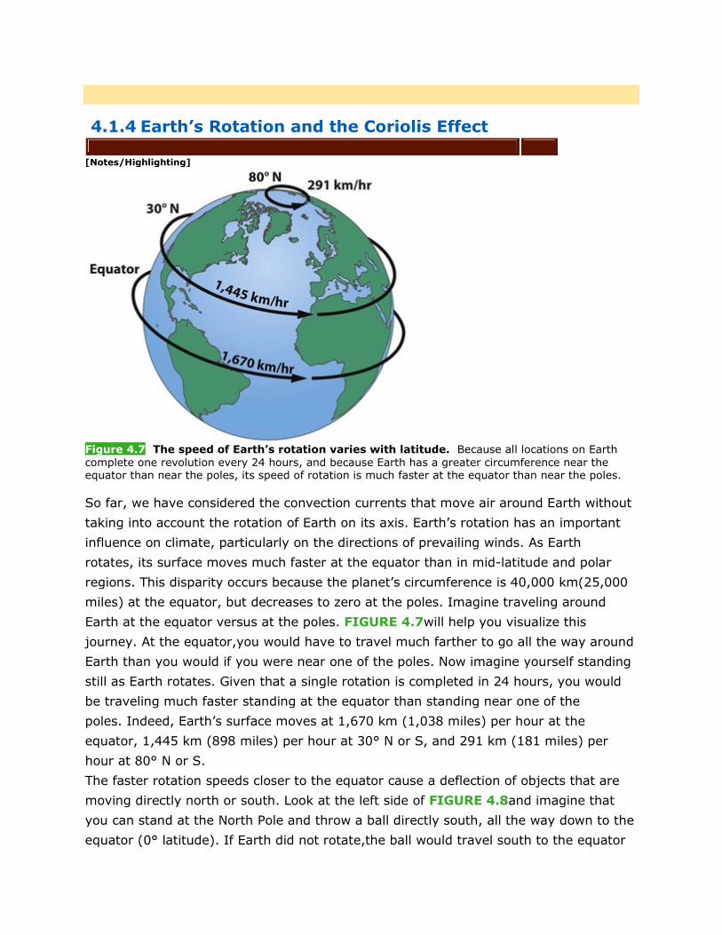
Figure 4.7 The speed of Earth’s rotation varies with latitude. Because all locations on Earth complete one revolution every 24 hours, and because Earth has a greater circumference near the equator than near the poles, its speed of rotation is much faster at the equator than near the poles.
So far, we have considered the convection currents that move air around Earth without
taking into account the rotation of Earth on its axis. Earth’s rotation has an important
influence on climate, particularly on the directions of prevailing winds. As Earth
rotates, its surface moves much faster at the equator than in mid-latitude and polar
regions. This disparity occurs because the planet’s circumference is 40,000 km(25,000
miles) at the equator, but decreases to zero at the poles. Imagine traveling around
Earth at the equator versus at the poles. FIGURE 4.7will help you visualize this
journey. At the equator,you would have to travel much farther to go all the way around
Earth than you would if you were near one of the poles. Now imagine yourself standing
still as Earth rotates. Given that a single rotation is completed in 24 hours, you would
be traveling much faster standing at the equator than standing near one of the
poles. Indeed, Earth’s surface moves at 1,670 km (1,038 miles) per hour at the
equator, 1,445 km (898 miles) per hour at 30° N or S, and 291 km (181 miles) per
hour at 80° N or S.
The faster rotation speeds closer to the equator cause a deflection of objects that are
moving directly north or south. Look at the left side of FIGURE 4.8and imagine that
you can stand at the North Pole and throw a ball directly south, all the way down to the
equator (0° latitude). If Earth did not rotate,the ball would travel south to the equator
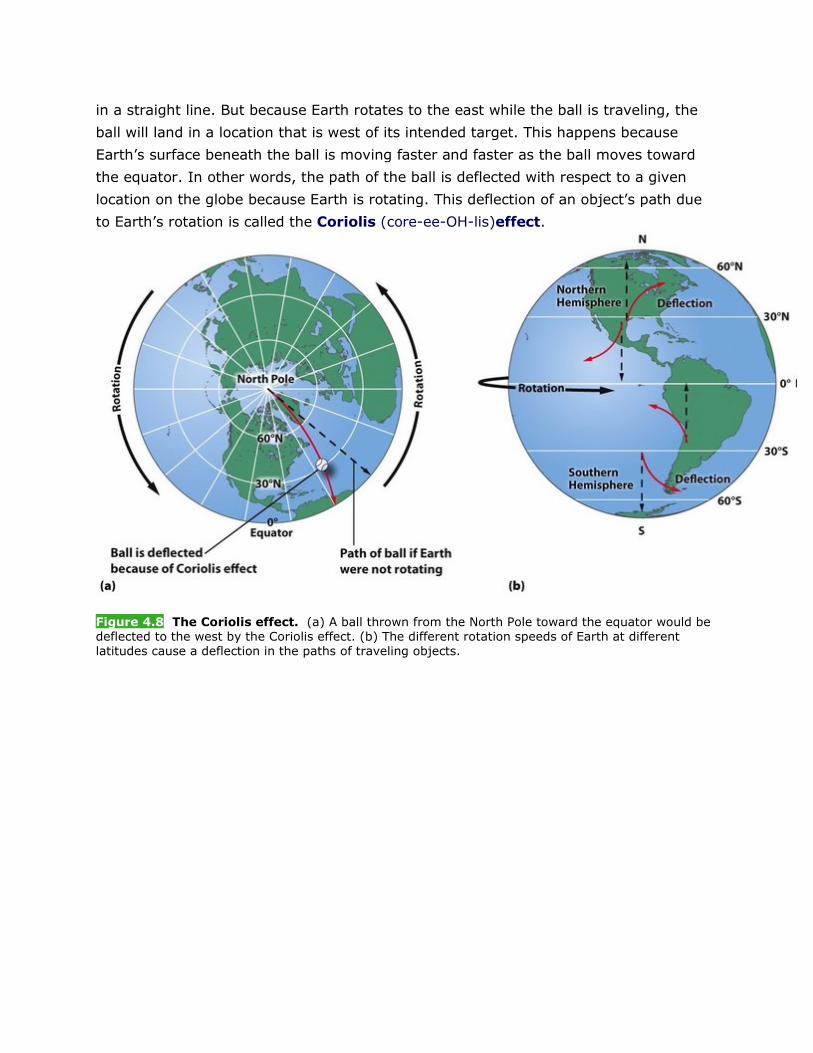
in a straight line. But because Earth rotates to the east while the ball is traveling, the
ball will land in a location that is west of its intended target. This happens because
Earth’s surface beneath the ball is moving faster and faster as the ball moves toward
the equator. In other words, the path of the ball is deflected with respect to a given
location on the globe because Earth is rotating. This deflection of an object’s path due
to Earth’s rotation is called the Coriolis (core-ee-OH-lis)effect.
Figure 4.8 The Coriolis effect. (a) A ball thrown from the North Pole toward the equator would be deflected to the west by the Coriolis effect. (b) The different rotation speeds of Earth at different latitudes cause a deflection in the paths of traveling objects.
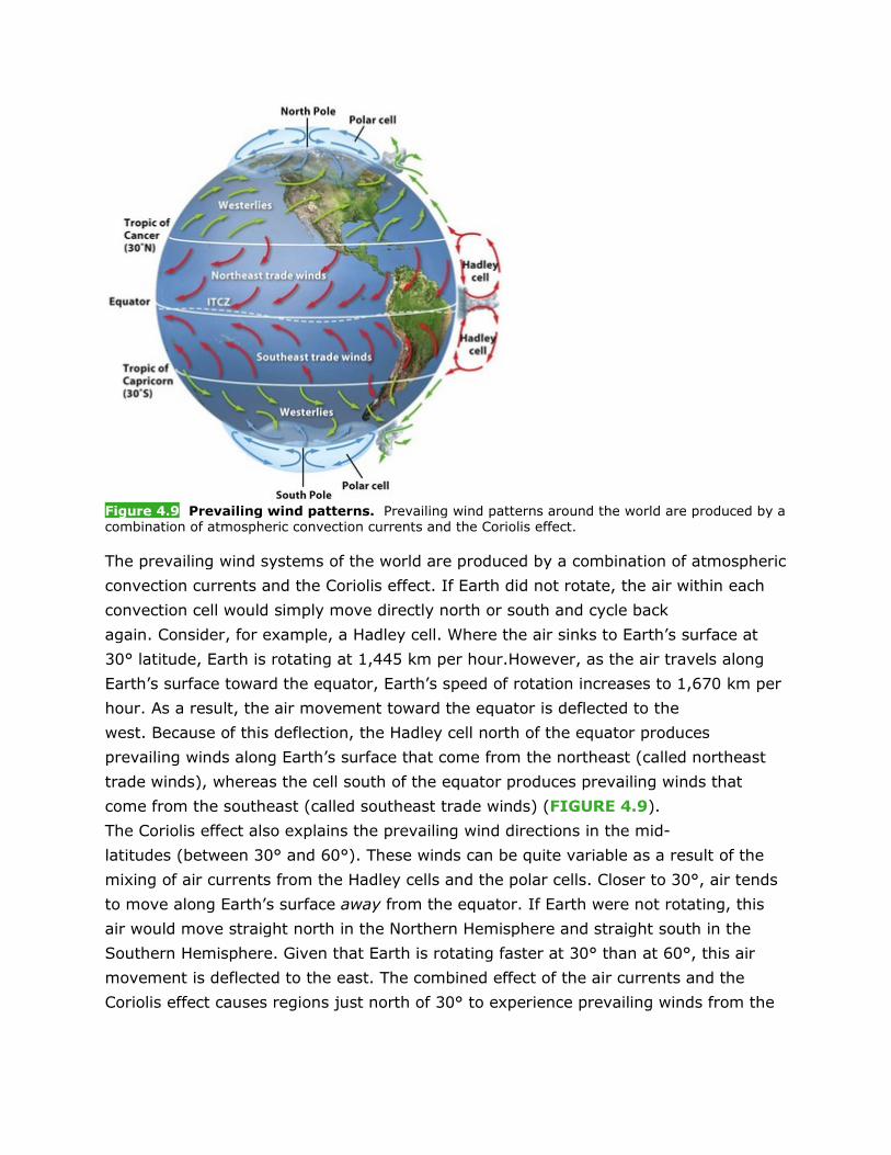
Figure 4.9 Prevailing wind patterns. Prevailing wind patterns around the world are produced by a combination of atmospheric convection currents and the Coriolis effect.
The prevailing wind systems of the world are produced by a combination of atmospheric
convection currents and the Coriolis effect. If Earth did not rotate, the air within each
convection cell would simply move directly north or south and cycle back
again. Consider, for example, a Hadley cell. Where the air sinks to Earth’s surface at
30° latitude, Earth is rotating at 1,445 km per hour.However, as the air travels along
Earth’s surface toward the equator, Earth’s speed of rotation increases to 1,670 km per
hour. As a result, the air movement toward the equator is deflected to the
west. Because of this deflection, the Hadley cell north of the equator produces
prevailing winds along Earth’s surface that come from the northeast (called northeast
trade winds), whereas the cell south of the equator produces prevailing winds that
come from the southeast (called southeast trade winds) (FIGURE 4.9).
The Coriolis effect also explains the prevailing wind directions in the mid-
latitudes (between 30° and 60°). These winds can be quite variable as a result of the
mixing of air currents from the Hadley cells and the polar cells. Closer to 30°, air tends
to move along Earth’s surface away from the equator. If Earth were not rotating, this
air would move straight north in the Northern Hemisphere and straight south in the
Southern Hemisphere. Given that Earth is rotating faster at 30° than at 60°, this air
movement is deflected to the east. The combined effect of the air currents and the
Coriolis effect causes regions just north of 30° to experience prevailing winds from the
southwest. In the Southern Hemisphere, the prevailing winds are from the north-
west. In both cases, these winds are called westerlies.
Finally, the Coriolis effect helps us understand the prevailing wind directions in the
polar regions. At Earth’s surface, the polar cells move air away from the poles and
toward 60° latitude. Given that Earth is rotating faster at 60° than at 90°‚ the air
movement is deflected to the west. Because of this, polar winds come out of the
northeast in the Northern Hemisphere and out of the southeast in the Southern
Hemisphere. These winds are called easterlies.
Simply stated, the atmospheric convection currents of tropical and polar latitudes, the
mixing of air currents in the mid-latitudes, and the Coriolis effect cause the prevailing
wind patterns that occur worldwide, although local features, such as mountain
ranges, can alter wind directions significantly.
4.1.5 Earth’s Tilt and the Seasons
[Notes/Highlighting]
As we saw in our discussion of the ITCZ, the latitude receiving the most direct sunlight
shifts over the course of the year. Because Earth’s axis of rotation is tilted
23.5°, Earth’s orbit around the Sun causes most regions of the world to experience
seasonal changes in temperature and precipitation.Specifically, when the Northern
Hemisphere is tilted toward the Sun, the Southern Hemisphere is tilted away from the
Sun, and vice versa.
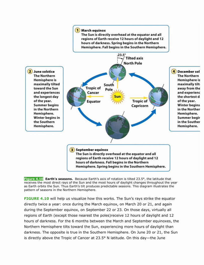
Figure 4.10 Earth’s seasons. Because Earth’s axis of rotation is tilted 23.5°, the latitude that receives the most direct rays of the Sun and the most hours of daylight changes throughout the year as Earth orbits the Sun. Thus Earth’s tilt produces predictable seasons. This diagram illustrates the pattern of seasons in the Northern Hemisphere.
FIGURE 4.10 will help us visualize how this works. The Sun’s rays strike the equator
directly twice a year: once during the March equinox, on March 20 or 21, and again
during the September equinox, on September 22 or 23. On those days, virtually all
regions of Earth (except those nearest the poles)receive 12 hours of daylight and 12
hours of darkness. For the 6 months between the March and September equinoxes, the
Northern Hemisphere tilts toward the Sun, experiencing more hours of daylight than
darkness. The opposite is true in the Southern Hemisphere. On June 20 or 21, the Sun
is directly above the Tropic of Cancer at 23.5° N latitude. On this day—the June
solstice—the Northern Hemisphere experiences more daylight hours than on any other
day of the year. For the 6 months between the September and March equinoxes, the
Northern Hemisphere tilts away from the Sun,experiencing fewer hours of daylight than
darkness. On December 21 or 22—the December solstice—the Sun is directly over the
Tropic of Capricorn at 23.5° S latitude. On this day, the Northern Hemisphere
experiences its shortest daylight period of the year, and the Southern Hemisphere
experiences its longest daylight period of the year.
4.1.6 Ocean Currents
[Notes/Highlighting]
So far we have examined four processes that influence Earth’s weather and
climate: unequal heating of Earth, atmospheric convection currents, the rotation of
Earth and the Coriolis effect, and Earth’s orbit around the Sun on a tilted axis. The fifth
global process that influences weather and climate is the circulation of ocean
waters, both at the surface and in the deep ocean.
Ocean currents are driven by a combination of temperature, gravity,prevailing
winds, the Coriolis effect, and the locations of continents. As we have already
observed, the tropics receive the most direct sunlight throughout the year, and as a
result, tropical waters are generally warm.Warm water, like warm air, expands and
rises. This process raises the tropical water surface about 8 cm (3 inches) higher in
elevation than mid-latitude waters. While this difference might seem trivial, the slight
slope is sufficient for the force of gravity to make water flow away from the equator.
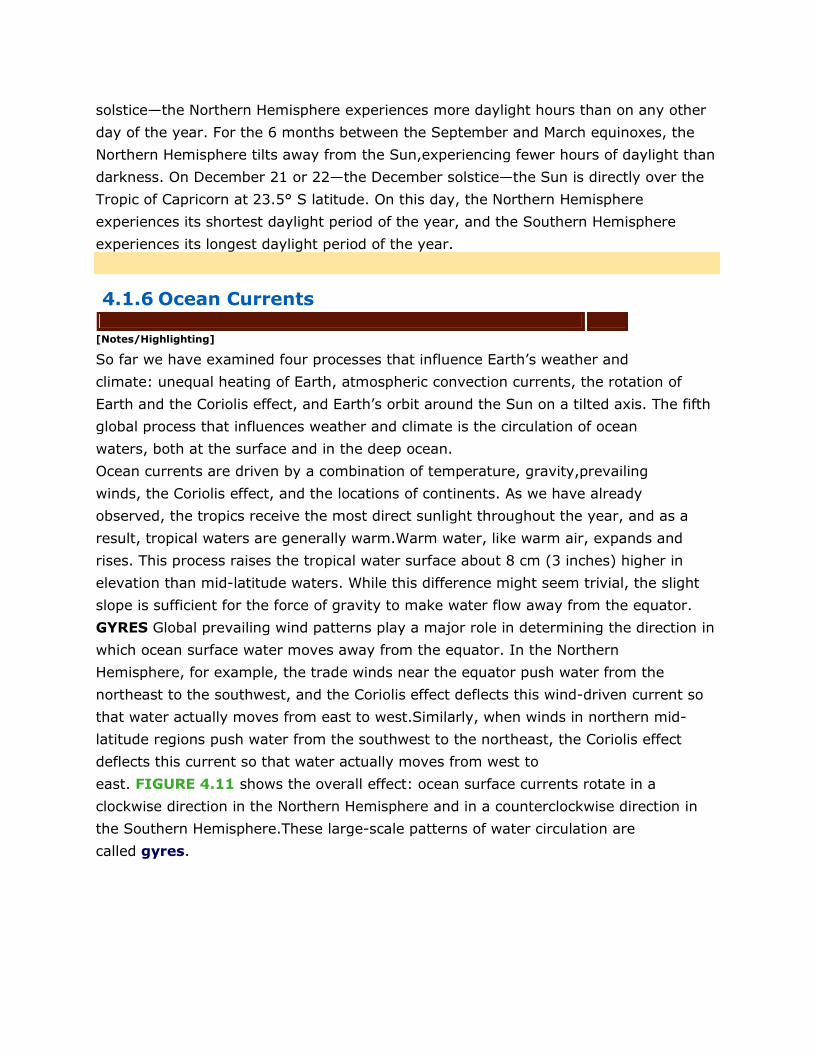
GYRES Global prevailing wind patterns play a major role in determining the direction in
which ocean surface water moves away from the equator. In the Northern
Hemisphere, for example, the trade winds near the equator push water from the
northeast to the southwest, and the Coriolis effect deflects this wind-driven current so
that water actually moves from east to west.Similarly, when winds in northern mid-
latitude regions push water from the southwest to the northeast, the Coriolis effect
deflects this current so that water actually moves from west to
east. FIGURE 4.11 shows the overall effect: ocean surface currents rotate in a
clockwise direction in the Northern Hemisphere and in a counterclockwise direction in
the Southern Hemisphere.These large-scale patterns of water circulation are
called gyres.
Figure 4.11 Oceanic circulation patterns. Oceanic circulation patterns are the result of differential heating, gravity, prevailing winds, the Coriolis effect, and the locations of continents. Each of the five major ocean basins contains a gyre driven by the trade winds in the tropics and the westerlies at mid-latitudes. The result is a clockwise circulation pattern in the Northern Hemisphere and a counterclockwise circulation pattern in the Southern Hemisphere. Along the west coasts of many continents, currents diverge and cause the upwelling of deeper and more fertile water.
Gyres redistribute heat in the ocean, just as atmospheric convection currents
redistribute heat in the atmosphere. Cold water from the polar regions moves along the
west coasts of continents, and the transport of cool air from immediately above these
waters causes cooler temperatures on land. For example, the California Current, which
flows south from the North Pacific along the coast of California, causes coastal areas of
California to have cooler temperatures than areas at similar latitudes on the east coast
of the United States. Similarly, warm water from the tropics moves along the east
coasts of continents, and the transport of warm air from immediately above these
waters causes warmer temperatures on land.
UPWELLING Ocean currents also help explain why some regions of the ocean support
highly productive ecosystems. Along the west coasts of most continents, for
example, the surface currents diverge, or separate from one another, causing deeper
waters to rise and replace the water that has moved away (see FIGURE 4.11). This
upward movement of water toward the surface is called upwelling. The deep waters
bring with them nutrients from the ocean bottom that support large populations of
producers. The producers, in turn, support large populations of fish that have long been
important to commercial fisheries.
THERMOHALINE CIRCULATION Another oceanic circulation pattern,thermohaline
circulation, drives the mixing of surface water and deep water. Scientists believe this
process is crucial for moving heat and nutrients around the globe.
Thermohaline circulation appears to be driven by surface waters that contain unusually
large amounts of salt. As FIGURE 4.11 shows, warm currents flow from the Gulf of
Mexico to the very cold North Atlantic. Some of this water freezes or evaporates, and
the salt that remains behind increases the salt concentration (salinity) of the
water. This cold, salty water is relatively dense,so it sinks to the bottom of the
ocean, mixing with deeper ocean waters. Two processes—the sinking of cold, salty
water at high latitudes and the rising of warm water near the equator—create the
movement necessary to drive a deep, cold current that slowly moves past Antarctica
and northward to the northern Pacific Ocean, where it returns to the surface and then
makes its way back to the Gulf of Mexico. This global round trip, traced
inFIGURE 4.12, can take hundreds of years to complete. Thermohaline circulation
helps to mix the water of all the oceans.
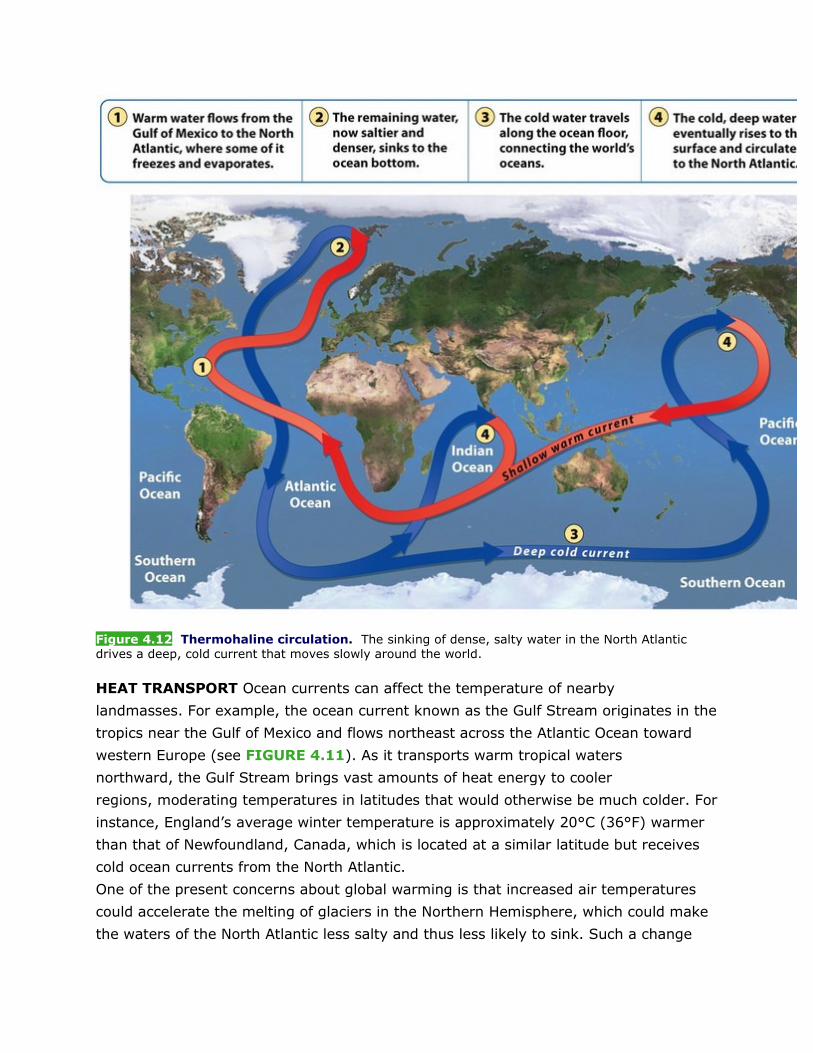
Figure 4.12 Thermohaline circulation. The sinking of dense, salty water in the North Atlantic drives a deep, cold current that moves slowly around the world.
HEAT TRANSPORT Ocean currents can affect the temperature of nearby
landmasses. For example, the ocean current known as the Gulf Stream originates in the
tropics near the Gulf of Mexico and flows northeast across the Atlantic Ocean toward
western Europe (see FIGURE 4.11). As it transports warm tropical waters
northward, the Gulf Stream brings vast amounts of heat energy to cooler
regions, moderating temperatures in latitudes that would otherwise be much colder. For
instance, England’s average winter temperature is approximately 20°C (36°F) warmer
than that of Newfoundland, Canada, which is located at a similar latitude but receives
cold ocean currents from the North Atlantic.
One of the present concerns about global warming is that increased air temperatures
could accelerate the melting of glaciers in the Northern Hemisphere, which could make
the waters of the North Atlantic less salty and thus less likely to sink. Such a change
could potentially shut down thermohaline circulation and stop the transport of warm
water to western Europe, making it a much colder place.
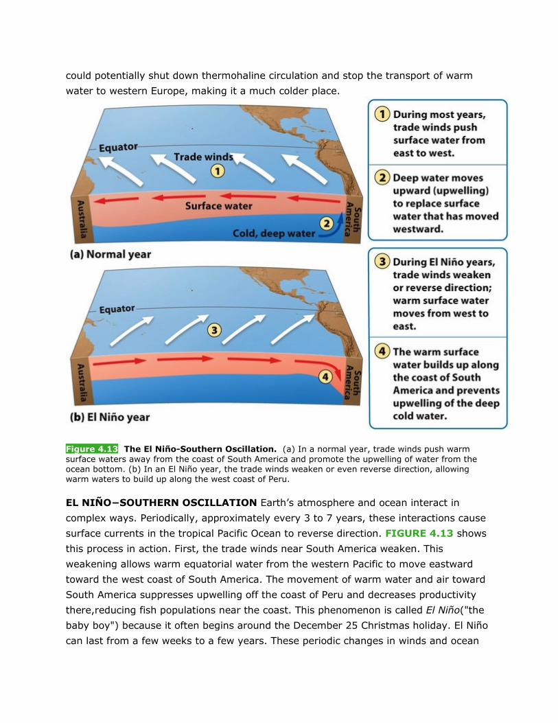
Figure 4.13 The El Niño-Southern Oscillation. (a) In a normal year, trade winds push warm surface waters away from the coast of South America and promote the upwelling of water from the ocean bottom. (b) In an El Niño year, the trade winds weaken or even reverse direction, allowing warm waters to build up along the west coast of Peru.
EL NIÑO−SOUTHERN OSCILLATION Earth’s atmosphere and ocean interact in
complex ways. Periodically, approximately every 3 to 7 years, these interactions cause
surface currents in the tropical Pacific Ocean to reverse direction. FIGURE 4.13 shows
this process in action. First, the trade winds near South America weaken. This
weakening allows warm equatorial water from the western Pacific to move eastward
toward the west coast of South America. The movement of warm water and air toward
South America suppresses upwelling off the coast of Peru and decreases productivity
there,reducing fish populations near the coast. This phenomenon is called El Niño("the
baby boy") because it often begins around the December 25 Christmas holiday. El Niño
can last from a few weeks to a few years. These periodic changes in winds and ocean
currents are collectively called the El Niño-Southern
Oscillation, or ENSO. Globally, the impact of ENSO includes cooler and wetter
conditions in the southeastern United States and unusually dry weather in southern
Africa and Southeast Asia.
Previous Section | Next Section
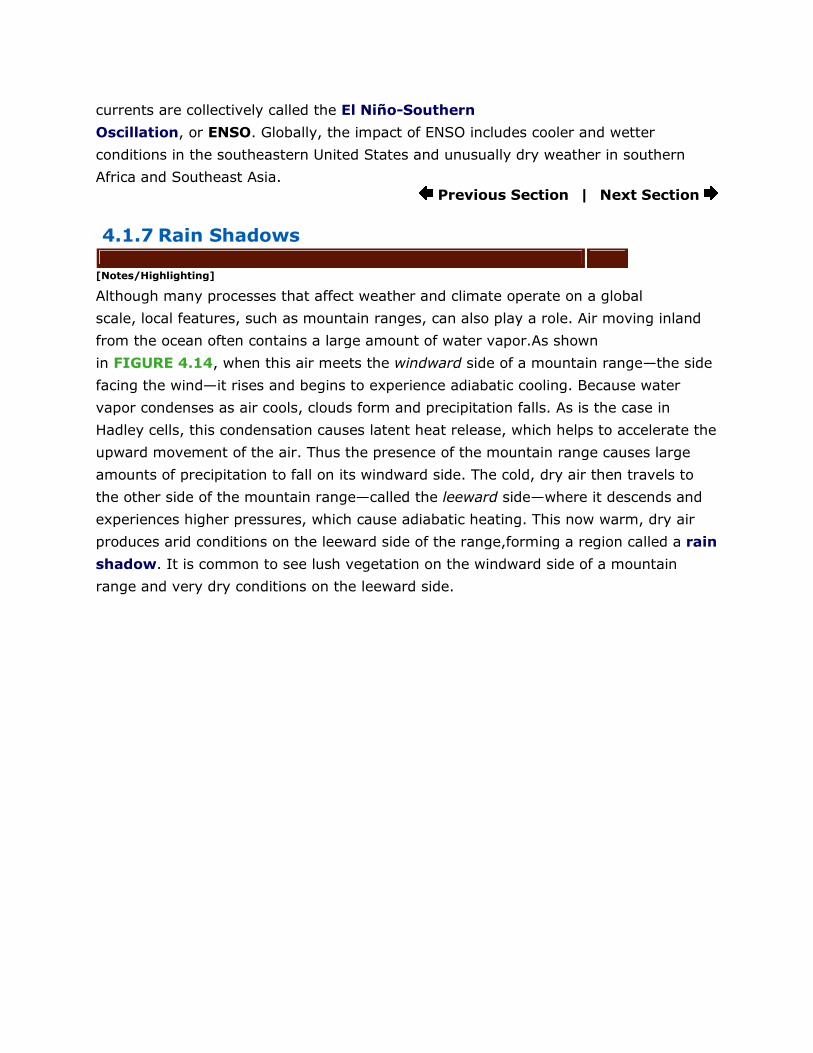
4.1.7 Rain Shadows
[Notes/Highlighting]
Although many processes that affect weather and climate operate on a global
scale, local features, such as mountain ranges, can also play a role. Air moving inland
from the ocean often contains a large amount of water vapor.As shown
in FIGURE 4.14, when this air meets the windward side of a mountain range—the side
facing the wind—it rises and begins to experience adiabatic cooling. Because water
vapor condenses as air cools, clouds form and precipitation falls. As is the case in
Hadley cells, this condensation causes latent heat release, which helps to accelerate the
upward movement of the air. Thus the presence of the mountain range causes large
amounts of precipitation to fall on its windward side. The cold, dry air then travels to
the other side of the mountain range—called the leeward side—where it descends and
experiences higher pressures, which cause adiabatic heating. This now warm, dry air
produces arid conditions on the leeward side of the range,forming a region called a rain
shadow. It is common to see lush vegetation on the windward side of a mountain
range and very dry conditions on the leeward side.
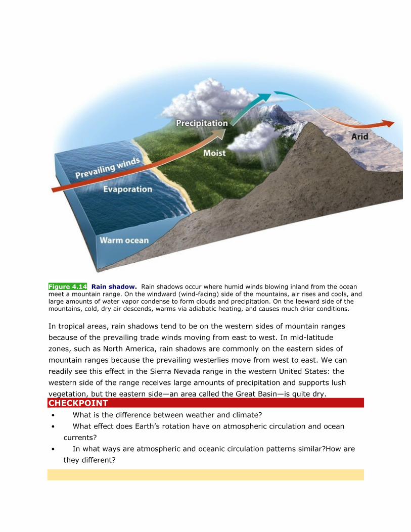
Figure 4.14 Rain shadow. Rain shadows occur where humid winds blowing inland from the ocean meet a mountain range. On the windward (wind-facing) side of the mountains, air rises and cools, and large amounts of water vapor condense to form clouds and precipitation. On the leeward side of the mountains, cold, dry air descends, warms via adiabatic heating, and causes much drier conditions.
In tropical areas, rain shadows tend to be on the western sides of mountain ranges
because of the prevailing trade winds moving from east to west. In mid-latitude
zones, such as North America, rain shadows are commonly on the eastern sides of
mountain ranges because the prevailing westerlies move from west to east. We can
readily see this effect in the Sierra Nevada range in the western United States: the
western side of the range receives large amounts of precipitation and supports lush
vegetation, but the eastern side—an area called the Great Basin—is quite dry.
CHECKPOINT • What is the difference between weather and climate?
• What effect does Earth’s rotation have on atmospheric circulation and ocean
currents?
• In what ways are atmospheric and oceanic circulation patterns similar?How are
they different?
4.2 Variations in climate determine the dominant plant growth forms of terrestrial biomes
[Notes/Highlighting]
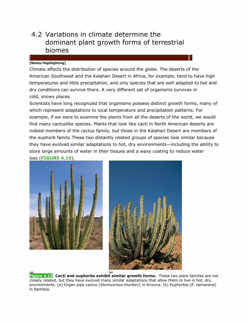
Climate affects the distribution of species around the globe. The deserts of the
American Southwest and the Kalahari Desert in Africa, for example, tend to have high
temperatures and little precipitation, and only species that are well adapted to hot and
dry conditions can survive there. A very different set of organisms survives in
cold, snowy places.
Scientists have long recognized that organisms possess distinct growth forms, many of
which represent adaptations to local temperature and precipitation patterns. For
example, if we were to examine the plants from all the deserts of the world, we would
find many cactuslike species. Plants that look like cacti in North American deserts are
indeed members of the cactus family, but those in the Kalahari Desert are members of
the euphorb family.These two distantly related groups of species look similar because
they have evolved similar adaptations to hot, dry environments—including the ability to
store large amounts of water in their tissues and a waxy coating to reduce water
loss (FIGURE 4.15).
Figure 4.15 Cacti and euphorbs exhibit similar growth forms. These two plant families are not closely related, but they have evolved many similar adaptations that allow them to live in hot, dry environments. (a) Organ pipe cactus (Stenocereus thurberi) in Arizona. (b) Euphorbia (E. damarana) in Namibia.
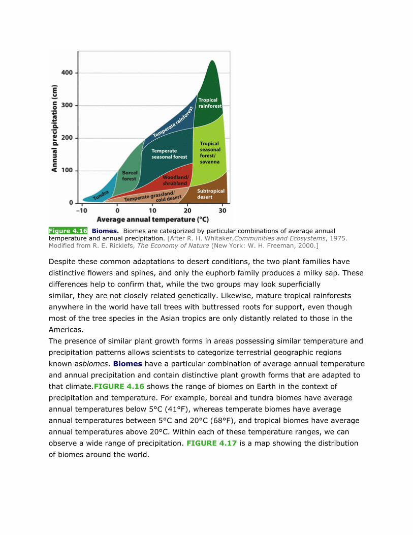
Figure 4.16 Biomes. Biomes are categorized by particular combinations of average annual temperature and annual precipitation. [After R. H. Whitaker,Communities and Ecosystems, 1975. Modified from R. E. Ricklefs, The Economy of Nature (New York: W. H. Freeman, 2000.]
Despite these common adaptations to desert conditions, the two plant families have
distinctive flowers and spines, and only the euphorb family produces a milky sap. These
differences help to confirm that, while the two groups may look superficially
similar, they are not closely related genetically. Likewise, mature tropical rainforests
anywhere in the world have tall trees with buttressed roots for support, even though
most of the tree species in the Asian tropics are only distantly related to those in the
Americas.
The presence of similar plant growth forms in areas possessing similar temperature and
precipitation patterns allows scientists to categorize terrestrial geographic regions
known asbiomes. Biomes have a particular combination of average annual temperature
and annual precipitation and contain distinctive plant growth forms that are adapted to
that climate.FIGURE 4.16 shows the range of biomes on Earth in the context of
precipitation and temperature. For example, boreal and tundra biomes have average
annual temperatures below 5°C (41°F), whereas temperate biomes have average
annual temperatures between 5°C and 20°C (68°F), and tropical biomes have average
annual temperatures above 20°C. Within each of these temperature ranges, we can
observe a wide range of precipitation. FIGURE 4.17 is a map showing the distribution
of biomes around the world.
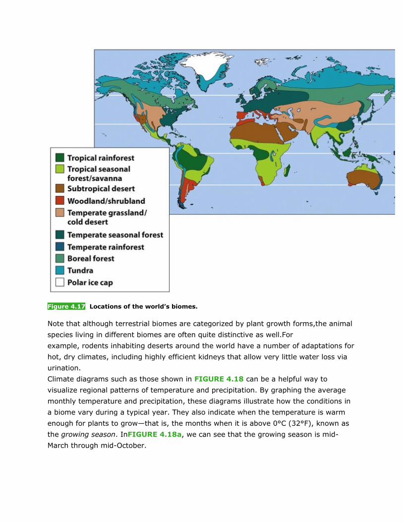
Figure 4.17 Locations of the world’s biomes.
Note that although terrestrial biomes are categorized by plant growth forms,the animal
species living in different biomes are often quite distinctive as well.For
example, rodents inhabiting deserts around the world have a number of adaptations for
hot, dry climates, including highly efficient kidneys that allow very little water loss via
urination.
Climate diagrams such as those shown in FIGURE 4.18 can be a helpful way to
visualize regional patterns of temperature and precipitation. By graphing the average
monthly temperature and precipitation, these diagrams illustrate how the conditions in
a biome vary during a typical year. They also indicate when the temperature is warm
enough for plants to grow—that is, the months when it is above 0°C (32°F), known as
the growing season. InFIGURE 4.18a, we can see that the growing season is mid-
March through mid-October.
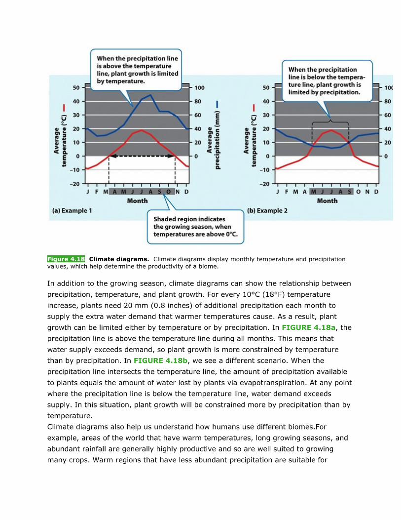
Figure 4.18 Climate diagrams. Climate diagrams display monthly temperature and precipitation values, which help determine the productivity of a biome.
In addition to the growing season, climate diagrams can show the relationship between
precipitation, temperature, and plant growth. For every 10°C (18°F) temperature
increase, plants need 20 mm (0.8 inches) of additional precipitation each month to
supply the extra water demand that warmer temperatures cause. As a result, plant
growth can be limited either by temperature or by precipitation. In FIGURE 4.18a, the
precipitation line is above the temperature line during all months. This means that
water supply exceeds demand, so plant growth is more constrained by temperature
than by precipitation. In FIGURE 4.18b, we see a different scenario. When the
precipitation line intersects the temperature line, the amount of precipitation available
to plants equals the amount of water lost by plants via evapotranspiration. At any point
where the precipitation line is below the temperature line, water demand exceeds
supply. In this situation, plant growth will be constrained more by precipitation than by
temperature.
Climate diagrams also help us understand how humans use different biomes.For
example, areas of the world that have warm temperatures, long growing seasons, and
abundant rainfall are generally highly productive and so are well suited to growing
many crops. Warm regions that have less abundant precipitation are suitable for
growing grains such as wheat and for grazing domesticated animals, including cattle
and sheep. Colder regions are often best used to grow forests for harvesting lumber.
We can divide terrestrial biomes into three categories: tundra and boreal
forest, temperate, and tropical. Within these three categories are a total of nine
biomes. We will examine each of these biomes in turn, looking at its temperature and
precipitation patterns, geographic distribution, and typical plant growth forms.
4.2.1 Tundra
[Notes/Highlighting]
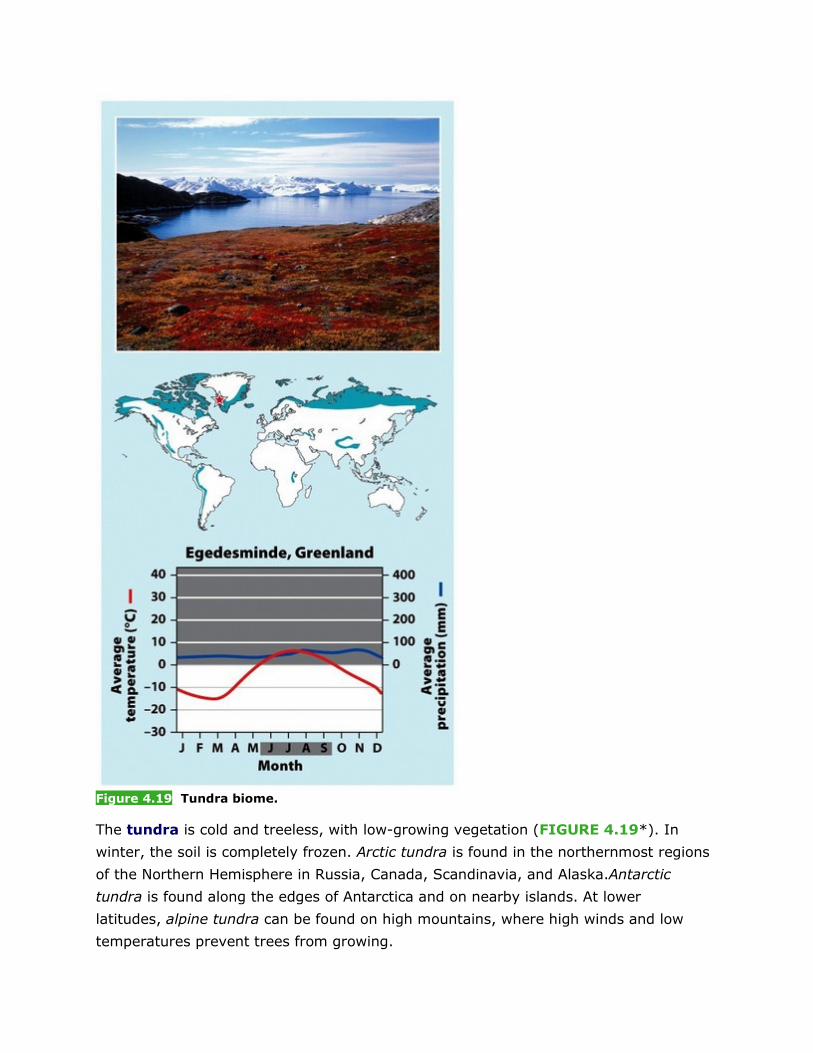
Figure 4.19 Tundra biome.
The tundra is cold and treeless, with low-growing vegetation (FIGURE 4.19*). In
winter, the soil is completely frozen. Arctic tundra is found in the northernmost regions
of the Northern Hemisphere in Russia, Canada, Scandinavia, and Alaska.Antarctic
tundra is found along the edges of Antarctica and on nearby islands. At lower
latitudes, alpine tundra can be found on high mountains, where high winds and low
temperatures prevent trees from growing.
The tundra’s growing season is very short, usually only about 4 months during
summer, when the polar region is tilted toward the Sun and the days are very
long. During this time the upper layer of soil thaws, creating pools of standing water
that are ideal habitat for mosquitoes and other insects.The underlying subsoil, known
as permafrost, is an impermeable, permanently frozen layer that prevents water from
draining and roots from penetrating. Permafrost, combined with the cold temperatures
and short growing season, prevents deeprooted plants such as trees from living in the
tundra.
While the tundra receives little precipitation, there is enough to support some plant
growth. The characteristic plants of this biome, such as small woody
shrubs, mosses, heaths, and lichens, can grow in shallow, waterlogged soil and can
survive short growing seasons and bitterly cold winters.At these cold
temperatures, chemical reactions occur slowly, and as a result, dead plants and animals
decompose slowly. This slow rate of decomposition results in the accumulation of
organic matter in the soil over time and relatively low levels of soil nutrients.
* The diagrams in Figures 4.19 through 4.27 are afterhttp://climatediagrams.com.
4.2.2 Boreal Forest
[Notes/Highlighting]
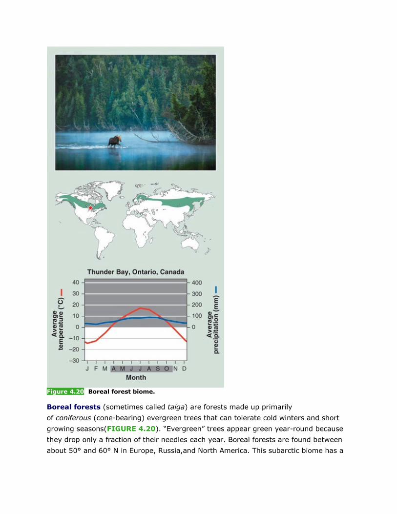
Figure 4.20 Boreal forest biome.
Boreal forests (sometimes called taiga) are forests made up primarily
of coniferous (cone-bearing) evergreen trees that can tolerate cold winters and short
growing seasons(FIGURE 4.20). “Evergreen” trees appear green year-round because
they drop only a fraction of their needles each year. Boreal forests are found between
about 50° and 60° N in Europe, Russia,and North America. This subarctic biome has a
very cold climate, and plant growth is more constrained by temperature than by
precipitation.
As in the tundra, cold temperatures and relatively low precipitation make decomposition
in boreal forests a slow process. In addition, the waxy needles of evergreen trees
contain compounds that are resistant to decomposition. As a result of the slow rate of
decomposition and the low nutrient content of the needles, boreal forest soils are
covered in a thick layer of organic material, but are poor in nutrients.
These factors—cold temperatures, low precipitation, and nutrient-poor soil—determine
the species of plants that can survive in boreal forests. In addition to coniferous trees
such as pine, spruce, and fir, some deciduous trees, such as birch, maple, and
aspen, can also be found in this biome. The needles of coniferous trees can tolerate
below-freezing conditions, but the deciduous trees drop all their leaves in autumn
before the subfreezing temperatures of winter have a chance to damage them. When
the weather warms, the deciduous trees produce new leaves and grow rapidly.
Because their soils are poor and their growing season is short, boreal forests are poorly
suited for agriculture. However, these forests serve as an important source of trees for
pulp, paper, and building materials. As a result, many have been extensively logged.
Previous Section
|
4.2.3 Temperate Rainforest
[Notes/Highlighting]
Moving to the mid-latitudes, where the climate is more temperate (with average annual
temperatures between 5°C and 20°C), we find a range of temperate biomes, including
temperate rainforest, temperate seasonal forest,woodland/shrubland, and temperate
grassland/cold desert.
Moderate temperatures and high precipitation typify temperate
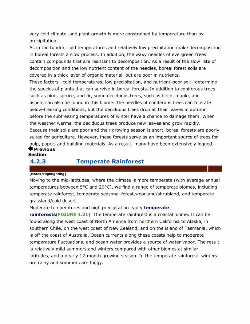
rainforests(FIGURE 4.21). The temperate rainforest is a coastal biome. It can be
found along the west coast of North America from northern California to Alaska, in
southern Chile, on the west coast of New Zealand, and on the island of Tasmania, which
is off the coast of Australia. Ocean currents along these coasts help to moderate
temperature fluctuations, and ocean water provides a source of water vapor. The result
is relatively mild summers and winters,compared with other biomes at similar
latitudes, and a nearly 12-month growing season. In the temperate rainforest, winters
are rainy and summers are foggy.
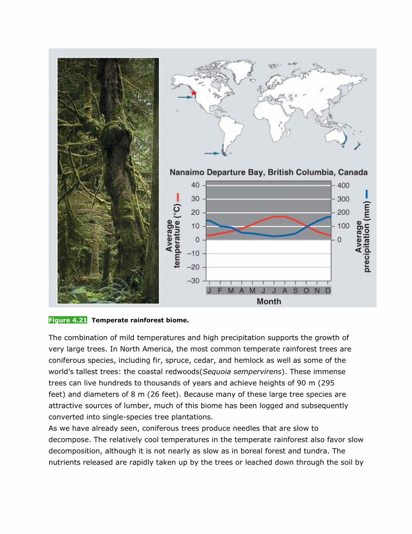
Figure 4.21 Temperate rainforest biome.
The combination of mild temperatures and high precipitation supports the growth of
very large trees. In North America, the most common temperate rainforest trees are
coniferous species, including fir, spruce, cedar, and hemlock as well as some of the
world’s tallest trees: the coastal redwoods(Sequoia sempervirens). These immense
trees can live hundreds to thousands of years and achieve heights of 90 m (295
feet) and diameters of 8 m (26 feet). Because many of these large tree species are
attractive sources of lumber, much of this biome has been logged and subsequently
converted into single-species tree plantations.
As we have already seen, coniferous trees produce needles that are slow to
decompose. The relatively cool temperatures in the temperate rainforest also favor slow
decomposition, although it is not nearly as slow as in boreal forest and tundra. The
nutrients released are rapidly taken up by the trees or leached down through the soil by
the abundant rainfall, which leaves the soil low in nutrients. Ferns and mosses, which
can survive in nutrient-poor soil,are commonly found living under the enormous trees.
4.2.4 Temperate Seasonal Forest
[Notes/Highlighting]
Temperate seasonal forests are more abundant than temperate
rainforests(FIGURE 4.22). They are found in the eastern United
States, Japan, China,Europe, Chile, and eastern Australia. Temperate seasonal forests
receive over 1 m (39 inches) of precipitation annually. Away from the moderating
influence of the ocean, these forests experience much warmer summers and colder
winters than temperate rainforests. They are dominated by broadleaf deciduous trees
such as beech, maple, oak, and hickory, although some coniferous tree species may
also be present. Because of the predominance of deciduous trees, these forests are also
called temperate deciduous forests.
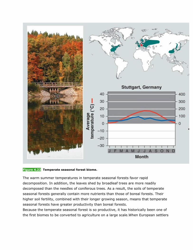
Figure 4.22 Temperate seasonal forest biome.
The warm summer temperatures in temperate seasonal forests favor rapid
decomposition. In addition, the leaves shed by broadleaf trees are more readily
decomposed than the needles of coniferous trees. As a result, the soils of temperate
seasonal forests generally contain more nutrients than those of boreal forests. Their
higher soil fertility, combined with their longer growing season, means that temperate
seasonal forests have greater productivity than boreal forests.
Because the temperate seasonal forest is so productive, it has historically been one of
the first biomes to be converted to agriculture on a large scale.When European settlers

arrived in North America, they cleared large areas of the eastern forests for agriculture
and dwellings.
Previous Section | Next Se
4.2.5 Woodland/Shrubland
[Notes/Highlighting]
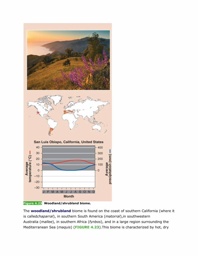
Figure 4.23 Woodland/shrubland biome.
The woodland/shrubland biome is found on the coast of southern California (where it
is calledchaparral), in southern South America (matorral),in southwestern
Australia (mallee), in southern Africa (fynbos), and in a large region surrounding the
Mediterranean Sea (maquis) (FIGURE 4.23).This biome is characterized by hot, dry
summers and mild, rainy winters. There is a 12-month growing season, but plant
growth is constrained by low precipitation in summer and by relatively low
temperatures in winter.
The hot, dry summers of the woodland/shrubland biome favor the natural occurrence of
wildfires.Plants of this biome are well adapted to both fire and drought. Many plants
quickly resprout after a fire. Others produce seeds that open only upon exposure to the
intense heat of a fire. Typical plants of this biome include drought-resistant shrubs such
as yucca, scrub oak, and sagebrush.Soils in this biome are low in nutrients because of
leaching by the winter rains. As a result, the major agricultural uses of this biome are
grazing animals and growing drought-tolerant deep-rooted crops,such as grapes to
make wine.
Previous Section | Next Section
4.2.6 Temperate Grassland/Cold Desert
[Notes/Highlighting]
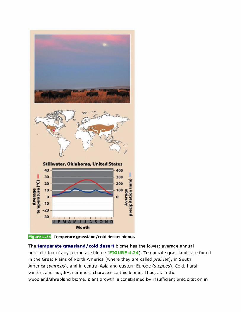
Figure 4.24 Temperate grassland/cold desert biome.
The temperate grassland/cold desert biome has the lowest average annual
precipitation of any temperate biome (FIGURE 4.24). Temperate grasslands are found
in the Great Plains of North America (where they are called prairies), in South
America (pampas), and in central Asia and eastern Europe (steppes). Cold, harsh
winters and hot,dry, summers characterize this biome. Thus, as in the
woodland/shrubland biome, plant growth is constrained by insufficient precipitation in
summer and cold temperatures in winter. Fires are common, as the dry and frequently
windy conditions fan flames ignited by lightning.Although estimates vary, it is thought
that,historically, large wildfires occurred in this biome every few years, sometimes
burning as much as 10,000 ha (nearly 25,000 acres) in a single fire.
Typical plants of temperate grasslands include grasses and nonwoody flowering
plants. These plants are generally well adapted to wildfires and frequent grazing by
animals. Their deep roots store energy to enable quick regrowth. Within this biome, the
amount of rainfall determines which plants can survive in a region. In the North
American prairies, for example, nearly 1 m (39 inches) of rain falls per year on the
eastern edge of the biome, supporting grasses that can grow up to 2.5 m (8
feet) high. Although these tallgrass prairies receive sufficient rainfall for trees to
grow,frequent wildfires keep trees from encroaching. In fact, the Native American
people are thought to have intentionally kept the eastern prairies free of trees by using
controlled burning. To the west,annual precipitation drops to 0.5 m (20 inches),favoring
the growth of grasses less than 0.5 m(20 inches) tall. These shortgrass prairies are
simply too dry to support trees or tall grasses.Farther west, in the rain shadow of the
Rocky Mountains, annual precipitation continues to decline to 0.25 m (10 inches). In
this region, the shortgrass prairie gives way to cold desert.
Cold deserts, also known as temperate deserts, have even sparser vegetation than
shortgrass prairies. Cold deserts are distinct from subtropical deserts in that they have
much colder winters and do not support the characteristic plant growth forms of hot
deserts, such as cacti and euphorbs.
The combination of a relatively long growing season and rapid decomposition that adds
large amounts of nutrients to the soil makes temperate grasslands very
productive. More than 98 percent of the tallgrass prairie in the United States has been
converted to agriculture. The less productive shortgrass prairie is predominantly used
for growing wheat and grazing cattle.
4.2.7 Tropical Rainforest
[Notes/Highlighting]
In the tropics, average annual temperatures exceed 20°C. Here we find the tropical
biomes: tropical rainforests, tropical seasonal forests/savannas, and subtropical
deserts.
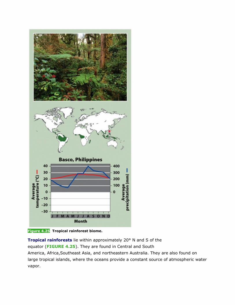
Figure 4.25 Tropical rainforest biome.
Tropical rainforests lie within approximately 20° N and S of the
equator (FIGURE 4.25). They are found in Central and South
America, Africa,Southeast Asia, and northeastern Australia. They are also found on
large tropical islands, where the oceans provide a constant source of atmospheric water
vapor.
The tropical rainforest biome is warm and wet,with little seasonal temperature
variation.Precipitation occurs frequently, although there are seasonal patterns in
precipitation that depend on when the ITCZ passes overhead. Because of the warm
temperatures and abundant rainfall,productivity is high, and decomposition is extremely
rapid. The lush vegetation takes up nutrients quickly, leaving few nutrients to
accumulate in the soil. Because of its high productivity, approximately 24,000
ha (59,500 acres) of tropical rainforest are cleared each year for agriculture. But the
high rate of decomposition causes the soils to lose their fertility quickly. As a
result, farmers growing crops on tropical soils often have to keep moving to newly
deforested areas.
Tropical rainforests contain more biodiversity per hectare than any other terrestrial
biome and contain up to two-thirds of Earth’s terrestrial species. These forests have
several distinctive layers of vegetation. Large trees form a forestcanopy that shades the
underlying vegetation.Several layers of successively shorter trees make up
the subcanopy, also known as the understory.Attached to the trunks and branches of
the trees are epiphytes, plants that hold small pools of water that support small aquatic
ecosystems far above the forest floor. Numerous species of woody vines (also
called lianas) are rooted in the soil, but climb up the trunks of trees and often into the
canopy.
4.2.8 Tropical Seasonal Forest/Savanna
[Notes/Highlighting]
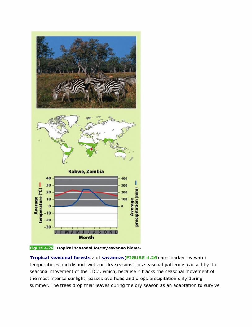
Figure 4.26 Tropical seasonal forest/savanna biome.
Tropical seasonal forests and savannas(FIGURE 4.26) are marked by warm
temperatures and distinct wet and dry seasons.This seasonal pattern is caused by the
seasonal movement of the ITCZ, which, because it tracks the seasonal movement of
the most intense sunlight, passes overhead and drops precipitation only during
summer. The trees drop their leaves during the dry season as an adaptation to survive
the drought conditions, then produce new leaves during the wet season. Thus these
forests are also called tropical deciduous forests.
Tropical seasonal forests are common in much of Central America, on the Atlantic coast
of South America, in southern Asia, in northwestern Australia, and in sub-Saharan
Africa. Areas with moderately long dry seasons support dense stands of shrubs and
trees. In areas with the longest dry seasons, the tropical seasonal climate leads to the
formation of savannas, relatively open landscapes dominated by grasses and scattered
deciduous trees. Common plants in this biome include acacia and baobab trees. Grazing
and fire discourage the growth of many smaller woody plants and keep the savanna
landscape open. The presence of trees and a warmer average annual temperature
distinguish savannas from grasslands.
The warm temperatures of the tropical seasonal forest/savanna biome promote
decomposition, but the low amounts of precipitation constrain plants from using the soil
nutrients that are released. As a result, the soils of this biome are fairly fertile and can
be farmed. Their fertility has resulted in the conversion of large areas of tropical
seasonal forest and savanna into agricultural fields and grazing lands. For
example, over 99 percent of the tropical seasonal forest of Pacific Central America and
the Atlantic coast of South America has been converted to human uses, including
agriculture and grazing.
4.2.9 Subtropical Desert
[Notes/Highlighting]

Figure 4.27 Subtropical desert biome.
At roughly 30° N and S, hot temperatures,extremely dry conditions, and sparse
vegetation prevail (FIGURE 4.27). This latitudinal band ofsubtropical deserts, also
known as hot deserts,includes the Mojave Desert in the southwestern United
States, the Sahara Desert in Africa, the Arabian Desert of the Middle East, and the
Great Victoria Desert of Australia. Cacti, euphorbs, and succulent plants are well
adapted to this biome. To prevent water loss, the leaves of desert plants may be
small, nonexistent, or modified into spines, and the outer layer of the plant is thick,with
few pores for water and air exchange. Most photosynthesis occurs along the plant
stem, which stores water so that photosynthesis can continue even during very dry
periods. To protect themselves from herbivores, desert plants have developed defense
mechanisms such as spines to discourage grazing.
When rain does fall, the desert landscape is transformed. Annual plants—those that live
for only a few months, reproduce, and die—grow rapidly during periods of rain. In
contrast,perennial plants—those that live for many years—experience spurts of growth
when it rains, but then exhibit little growth during the rest of the year. The slow overall
growth of perennial plants in subtropical deserts makes them particularly vulnerable to
disturbance, and they have long recovery times.
CHECKPOINT • What characteristics are used to identify terrestrial biomes?
• What are some of the ways that humans use different terrestrial biomes?
• What characteristics of a terrestrial biome determine its productivity?
Previous Section
4.3 Aquatic biomes are categorized by salinity, depth, and water flow
[Notes/Highlighting]
Whereas terrestrial biomes are categorized by dominant plant growth forms,aquatic
biomes are categorized by physical characteristics such as salinity,depth, and water
flow. Temperature is an important factor in determining which species can survive in a
particular aquatic habitat, but it is not a factor used to categorize aquatic biomes.
Aquatic biomes fall into two broad categories: freshwater and marine.Freshwater
biomes include streams, rivers, lakes, and wetlands. Saltwater biomes, also known
as marine biomes, include shallow marine areas such as estuaries and coral reefs as
well as the open ocean.
4.3.1 Streams and Rivers
[Notes/Highlighting]
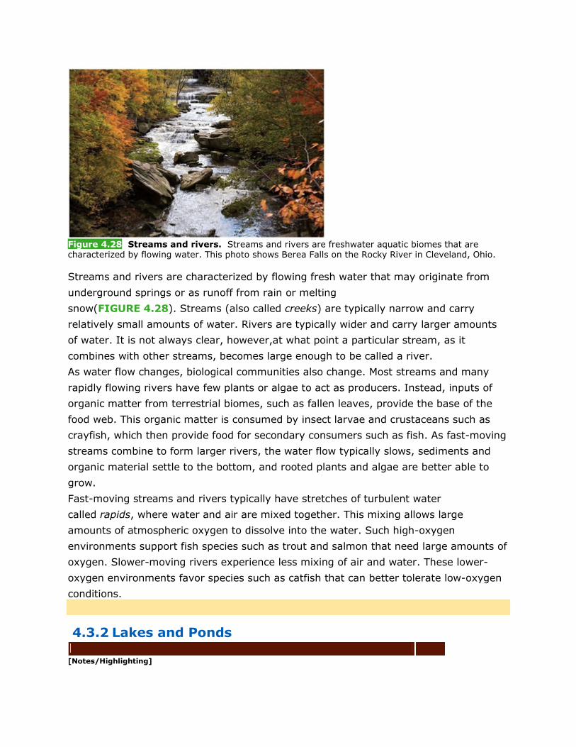
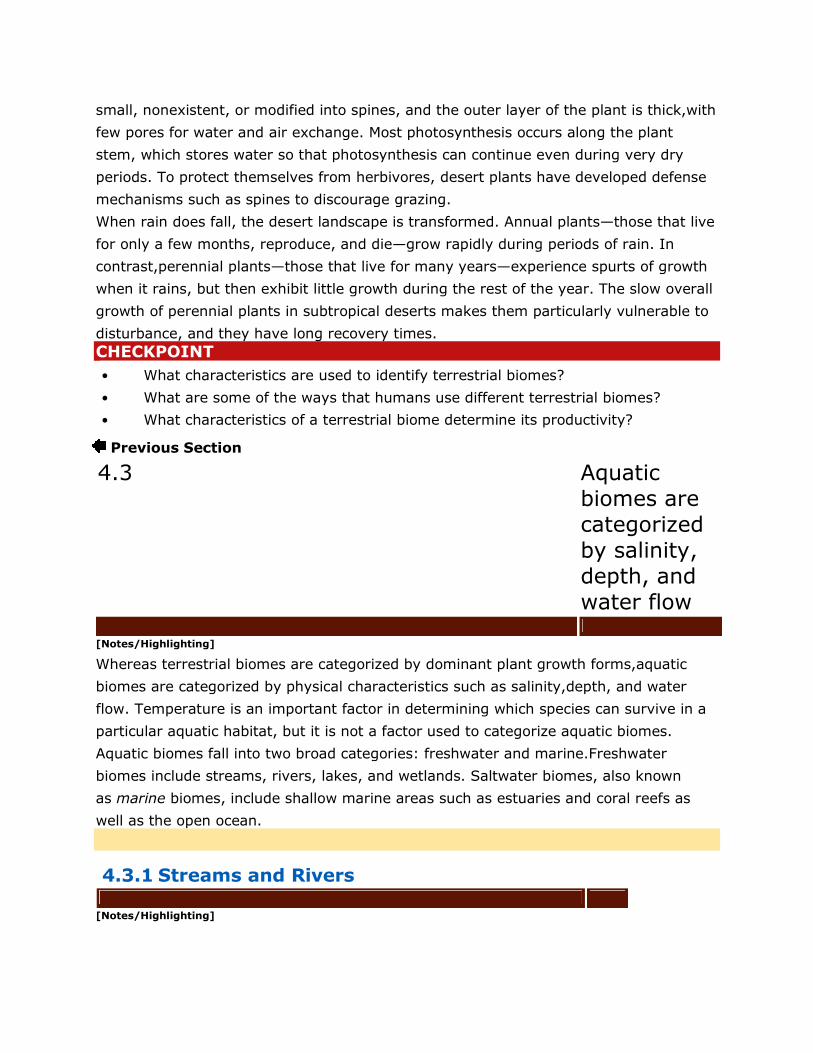
Figure 4.28 Streams and rivers. Streams and rivers are freshwater aquatic biomes that are characterized by flowing water. This photo shows Berea Falls on the Rocky River in Cleveland, Ohio.
Streams and rivers are characterized by flowing fresh water that may originate from
underground springs or as runoff from rain or melting
snow(FIGURE 4.28). Streams (also called creeks) are typically narrow and carry
relatively small amounts of water. Rivers are typically wider and carry larger amounts
of water. It is not always clear, however,at what point a particular stream, as it
combines with other streams, becomes large enough to be called a river.
As water flow changes, biological communities also change. Most streams and many
rapidly flowing rivers have few plants or algae to act as producers. Instead, inputs of
organic matter from terrestrial biomes, such as fallen leaves, provide the base of the
food web. This organic matter is consumed by insect larvae and crustaceans such as
crayfish, which then provide food for secondary consumers such as fish. As fast-moving
streams combine to form larger rivers, the water flow typically slows, sediments and
organic material settle to the bottom, and rooted plants and algae are better able to
grow.
Fast-moving streams and rivers typically have stretches of turbulent water
called rapids, where water and air are mixed together. This mixing allows large
amounts of atmospheric oxygen to dissolve into the water. Such high-oxygen
environments support fish species such as trout and salmon that need large amounts of
oxygen. Slower-moving rivers experience less mixing of air and water. These lower-
oxygen environments favor species such as catfish that can better tolerate low-oxygen
conditions.
4.3.2 Lakes and Ponds
[Notes/Highlighting]
Lakes and ponds contain standing water, at least some of which is too deep to support
emergent vegetation (plants that are rooted to the bottom and emerge above the
water’s surface). Lakes are larger than ponds, but as with streams and rivers, there is
no clear point at which a pond is considered large enough to be called a lake.
Figure 4.29 Lakes and ponds. (a) Lake George, in the Adirondack Park and Preserve, New York State. (b) In lakes and ponds, at least some of the standing water is too deep for emergent vegetation to grow.
As FIGURE 4.29 shows, lakes and ponds can be divided into several distinct
zones. The littoral zone is the shallow area of soil and water near the shore where
algae and emergent plants such as cattails grow. Most photosynthesis occurs in this
zone. In the open water, or limnetic zone, rooted plants can no longer
survive; floating algae called phytoplankton are the only photosynthetic
organisms. The limnetic zone extends as deep as sunlight can penetrate. Very deep
lakes have a region of water below the limnetic zone,called the profundal
zone. Because sunlight does not reach the profundal zone, producers cannot survive
there, so nutrients are not easily recycled into the food web. Bacteria decompose the
detritus that reaches the profundal zone, but they consume oxygen in the process. As a
result,dissolved oxygen concentrations are not sufficient to support many large
organisms. The muddy bottom of a lake or pond beneath the limnetic and profundal
zones is called the benthic zone.
4.3.3 Freshwater Wetlands
[Notes/Highlighting]
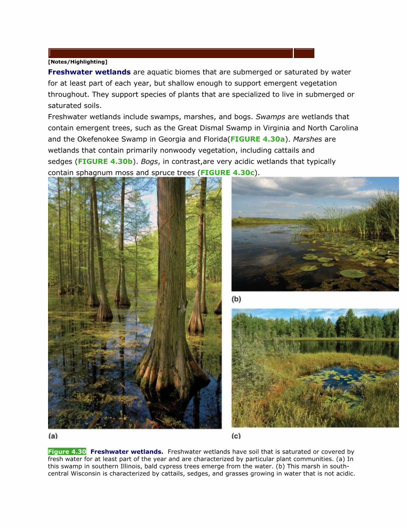
Freshwater wetlands are aquatic biomes that are submerged or saturated by water
for at least part of each year, but shallow enough to support emergent vegetation
throughout. They support species of plants that are specialized to live in submerged or
saturated soils.
Freshwater wetlands include swamps, marshes, and bogs. Swamps are wetlands that
contain emergent trees, such as the Great Dismal Swamp in Virginia and North Carolina
and the Okefenokee Swamp in Georgia and Florida(FIGURE 4.30a). Marshes are
wetlands that contain primarily nonwoody vegetation, including cattails and
sedges (FIGURE 4.30b). Bogs, in contrast,are very acidic wetlands that typically
contain sphagnum moss and spruce trees (FIGURE 4.30c).
Figure 4.30 Freshwater wetlands. Freshwater wetlands have soil that is saturated or covered by fresh water for at least part of the year and are characterized by particular plant communities. (a) In this swamp in southern Illinois, bald cypress trees emerge from the water. (b) This marsh in south-central Wisconsin is characterized by cattails, sedges, and grasses growing in water that is not acidic.
(c) This bog in northern Wisconsin is dominated by sphagnum moss as well as shrubs and trees that are adapted to acidic conditions.
Freshwater wetlands are among the most productive biomes on the planet,and they
provide several critical ecosystem services. For example, wetlands can take in large
amounts of rainwater and release it slowly into the groundwater or into nearby
streams, thus reducing the severity of floods and droughts. Wetlands also filter
pollutants from water, recharging the groundwater with clean water. Many bird species
depend on wetlands during migration or breeding. As many as one-third of all
endangered bird species in the United States spend some part of their lives in
wetlands, even though this biome makes up only 5 percent of the nation’s land
area. Unfortunately,more than half of the freshwater wetland area in the United States
has been drained for agriculture or development or to eliminate breeding grounds for
mosquitoes and various disease-causing organisms.
4.3.4 Salt Marshes
[Notes/Highlighting]
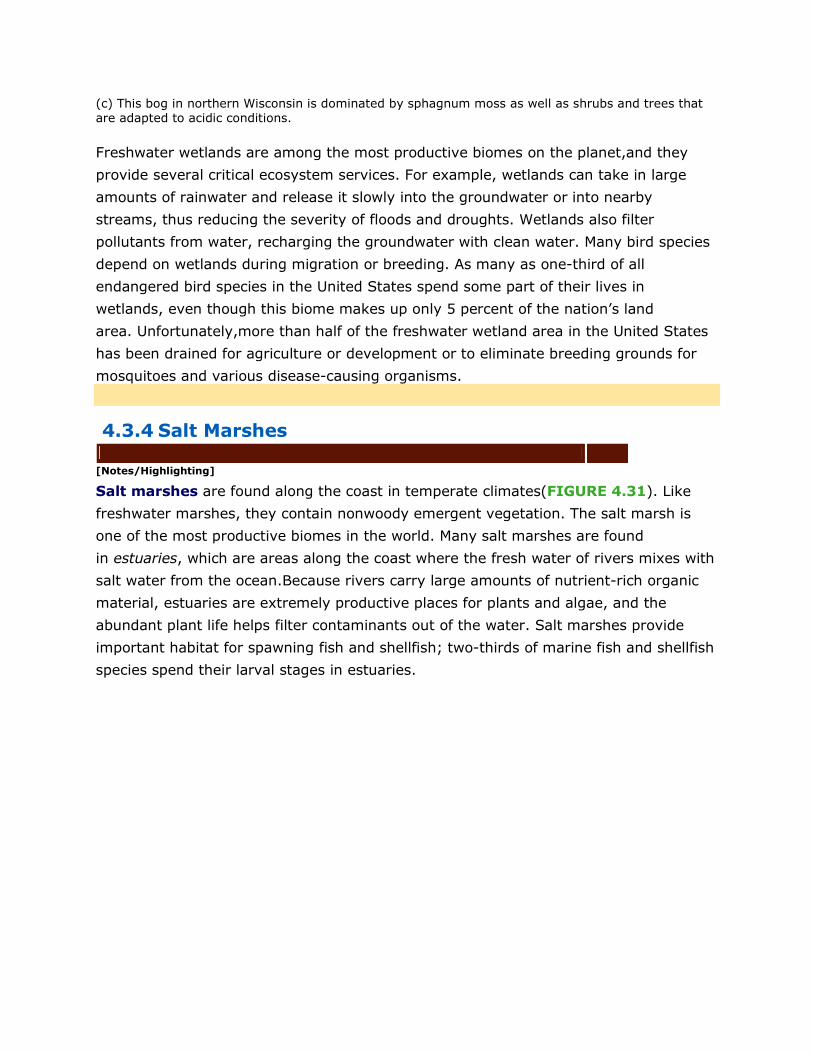
Salt marshes are found along the coast in temperate climates(FIGURE 4.31). Like
freshwater marshes, they contain nonwoody emergent vegetation. The salt marsh is
one of the most productive biomes in the world. Many salt marshes are found
in estuaries, which are areas along the coast where the fresh water of rivers mixes with
salt water from the ocean.Because rivers carry large amounts of nutrient-rich organic
material, estuaries are extremely productive places for plants and algae, and the
abundant plant life helps filter contaminants out of the water. Salt marshes provide
important habitat for spawning fish and shellfish; two-thirds of marine fish and shellfish
species spend their larval stages in estuaries.
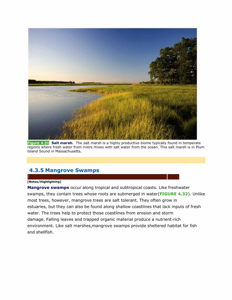
Figure 4.31 Salt marsh. The salt marsh is a highly productive biome typically found in temperate regions where fresh water from rivers mixes with salt water from the ocean. This salt marsh is in Plum Island Sound in Massachusetts.
4.3.5 Mangrove Swamps
[Notes/Highlighting]
Mangrove swamps occur along tropical and subtropical coasts. Like freshwater
swamps, they contain trees whose roots are submerged in water(FIGURE 4.32). Unlike
most trees, however, mangrove trees are salt tolerant. They often grow in
estuaries, but they can also be found along shallow coastlines that lack inputs of fresh
water. The trees help to protect those coastlines from erosion and storm
damage. Falling leaves and trapped organic material produce a nutrient-rich
environment. Like salt marshes,mangrove swamps provide sheltered habitat for fish
and shellfish.
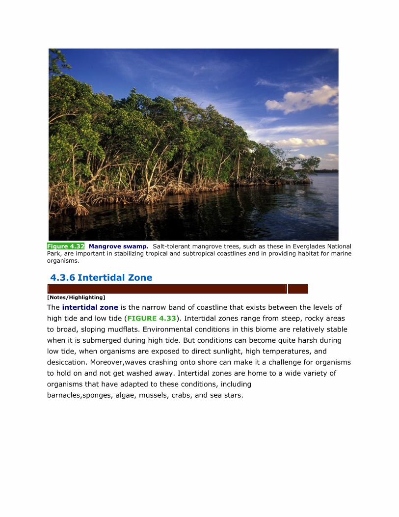
Figure 4.32 Mangrove swamp. Salt-tolerant mangrove trees, such as these in Everglades National Park, are important in stabilizing tropical and subtropical coastlines and in providing habitat for marine organisms.
4.3.6 Intertidal Zone
[Notes/Highlighting]
The intertidal zone is the narrow band of coastline that exists between the levels of
high tide and low tide (FIGURE 4.33). Intertidal zones range from steep, rocky areas
to broad, sloping mudflats. Environmental conditions in this biome are relatively stable
when it is submerged during high tide. But conditions can become quite harsh during
low tide, when organisms are exposed to direct sunlight, high temperatures, and
desiccation. Moreover,waves crashing onto shore can make it a challenge for organisms
to hold on and not get washed away. Intertidal zones are home to a wide variety of
organisms that have adapted to these conditions, including
barnacles,sponges, algae, mussels, crabs, and sea stars.
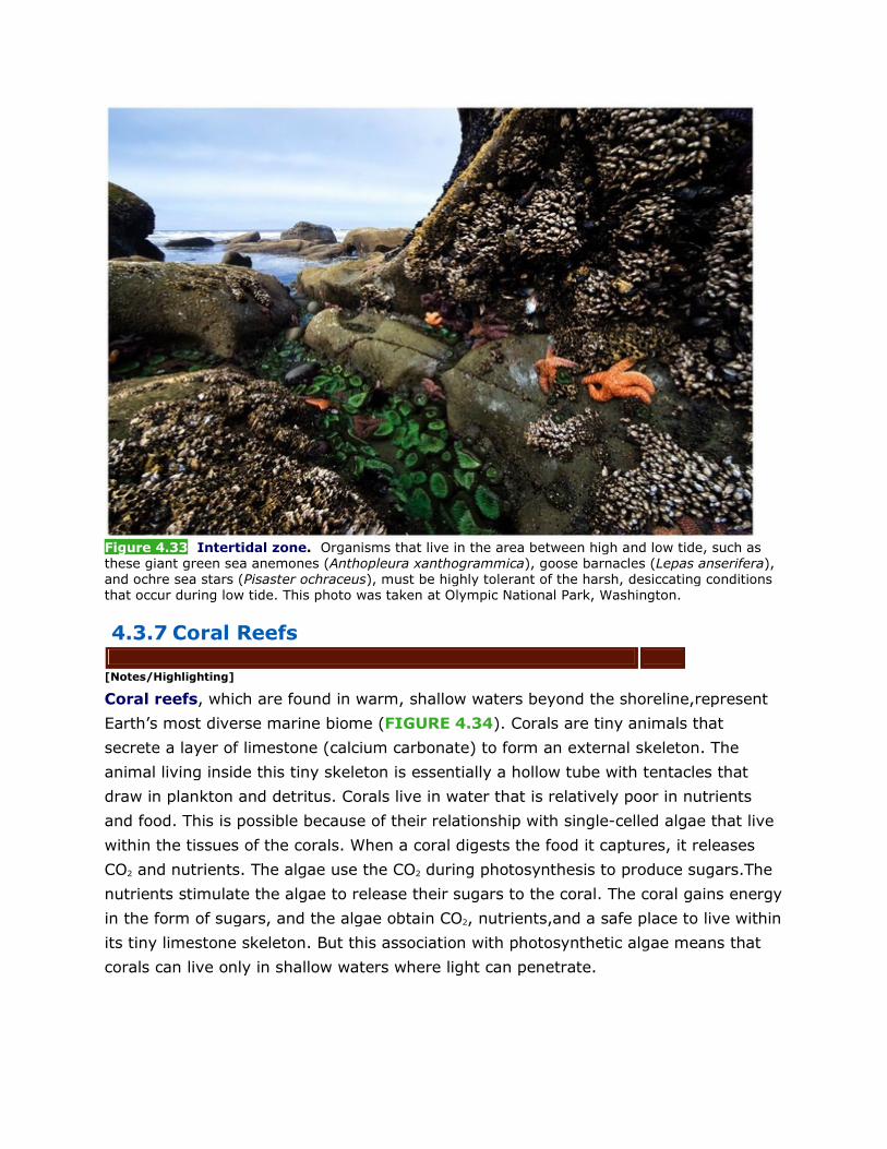
Figure 4.33 Intertidal zone. Organisms that live in the area between high and low tide, such as these giant green sea anemones (Anthopleura xanthogrammica), goose barnacles (Lepas anserifera), and ochre sea stars (Pisaster ochraceus), must be highly tolerant of the harsh, desiccating conditions that occur during low tide. This photo was taken at Olympic National Park, Washington.
4.3.7 Coral Reefs
[Notes/Highlighting]
Coral reefs, which are found in warm, shallow waters beyond the shoreline,represent
Earth’s most diverse marine biome (FIGURE 4.34). Corals are tiny animals that
secrete a layer of limestone (calcium carbonate) to form an external skeleton. The
animal living inside this tiny skeleton is essentially a hollow tube with tentacles that
draw in plankton and detritus. Corals live in water that is relatively poor in nutrients
and food. This is possible because of their relationship with single-celled algae that live
within the tissues of the corals. When a coral digests the food it captures, it releases
CO2 and nutrients. The algae use the CO2 during photosynthesis to produce sugars.The
nutrients stimulate the algae to release their sugars to the coral. The coral gains energy
in the form of sugars, and the algae obtain CO2, nutrients,and a safe place to live within
its tiny limestone skeleton. But this association with photosynthetic algae means that
corals can live only in shallow waters where light can penetrate.
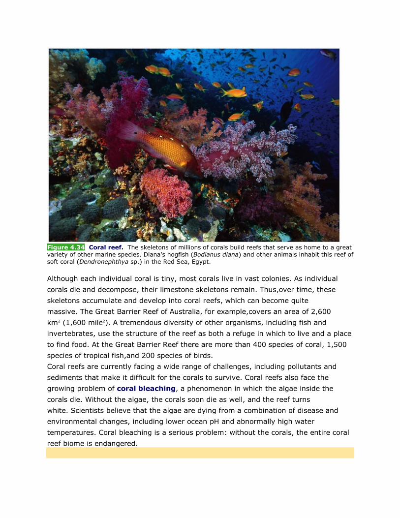
Figure 4.34 Coral reef. The skeletons of millions of corals build reefs that serve as home to a great variety of other marine species. Diana’s hogfish (Bodianus diana) and other animals inhabit this reef of soft coral (Dendronephthya sp.) in the Red Sea, Egypt.
Although each individual coral is tiny, most corals live in vast colonies. As individual
corals die and decompose, their limestone skeletons remain. Thus,over time, these
skeletons accumulate and develop into coral reefs, which can become quite
massive. The Great Barrier Reef of Australia, for example,covers an area of 2,600
km2 (1,600 mile2). A tremendous diversity of other organisms, including fish and
invertebrates, use the structure of the reef as both a refuge in which to live and a place
to find food. At the Great Barrier Reef there are more than 400 species of coral, 1,500
species of tropical fish,and 200 species of birds.
Coral reefs are currently facing a wide range of challenges, including pollutants and
sediments that make it difficult for the corals to survive. Coral reefs also face the
growing problem of coral bleaching, a phenomenon in which the algae inside the
corals die. Without the algae, the corals soon die as well, and the reef turns
white. Scientists believe that the algae are dying from a combination of disease and
environmental changes, including lower ocean pH and abnormally high water
temperatures. Coral bleaching is a serious problem: without the corals, the entire coral
reef biome is endangered.
4.3.8 The Open Ocean
[Notes/Highlighting]
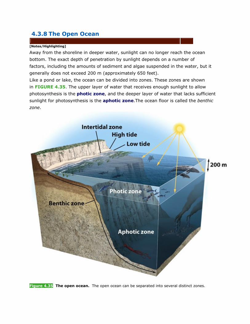
Away from the shoreline in deeper water, sunlight can no longer reach the ocean
bottom. The exact depth of penetration by sunlight depends on a number of
factors, including the amounts of sediment and algae suspended in the water, but it
generally does not exceed 200 m (approximately 650 feet).
Like a pond or lake, the ocean can be divided into zones. These zones are shown
in FIGURE 4.35. The upper layer of water that receives enough sunlight to allow
photosynthesis is the photic zone, and the deeper layer of water that lacks sufficient
sunlight for photosynthesis is the aphotic zone.The ocean floor is called the benthic
zone.
Figure 4.35 The open ocean. The open ocean can be separated into several distinct zones.
In the photic zone, algae are the major producers. They form the base of a food web
that includes tiny zooplankton, fish, and whales. Given the lack of light in the aphotic
zone, there are no photosynthetic producers there.However, there are some species of
bacteria that can use the energy contained in the bonds of methane and hydrogen
sulfide, which are both found in the deep ocean, to generate energy
via chemosynthesis rather than photosynthesis. These bacteria form the base of a
deep-ocean food web that includes animals such as tube
worms (see FIGURE 2.17d). The aphotic zone also contains a variety of organisms
that can generate their own light (a phenomenon called bioluminescence) to help them
feed in the dark waters. These organisms include several species of
crustaceans, jellyfish,squid, and fish.
The patterns that emerge as we study the terrestrial and aquatic biomes highlight the
fact that regional variations in global climate have a major effect on the types of
organisms that can live in different parts of the world. Among the terrestrial
biomes, temperature and precipitation affect the rate of decomposition of dead
organisms and the productivity of the soil.Understanding these patterns helps us
understand how humans have come to use the land in different ways: growing crops in
regions with enough water and a sufficient growing season, grazing domesticated
animals in drier areas,and harvesting lumber from forests. Among the aquatic
biomes, differences in water flow, depth, and salinity help us understand why different
species of producers and consumers, including commercially important species of fish
and shellfish, live in different regions of the world.
CHECKPOINT • How are aquatic biomes categorized? Why are they categorized differently than
terrestrial biomes?
• What are the different zones of lakes and the open ocean, and what defines
them?
• How does water depth or flow influence the organisms that live in an aquatic
biome?
WORKING TOWARD SUSTAINABILITY Is Your Coffee Made in the Shade?
A round the world, people enjoy drinking coffee. In the United States alone, 54 percent of
adults drink coffee every day, at an average of 3.1 cups per day. Worldwide, people
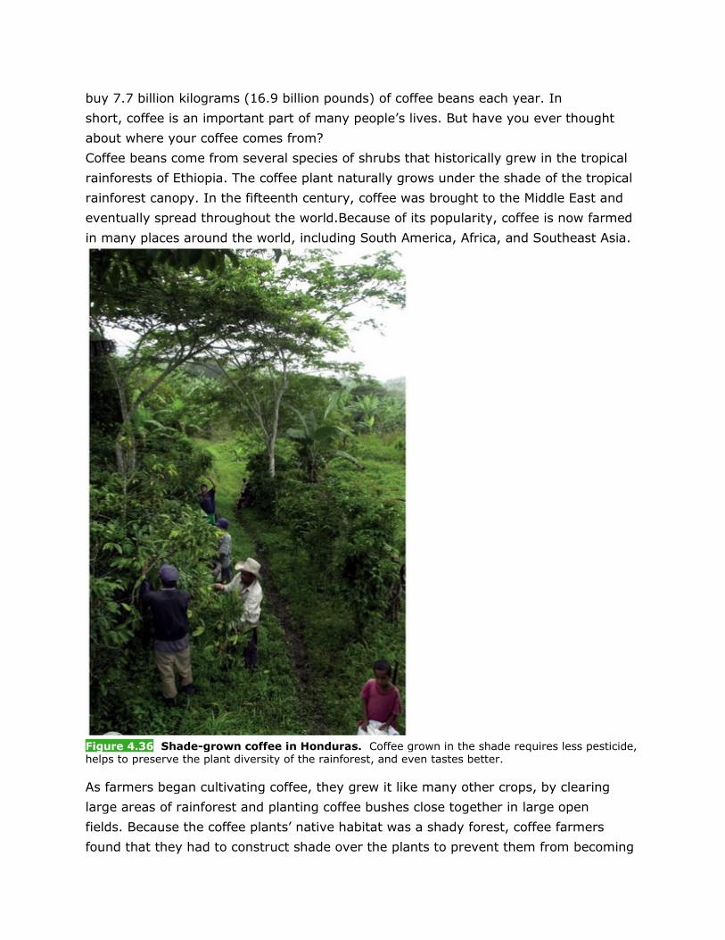
buy 7.7 billion kilograms (16.9 billion pounds) of coffee beans each year. In
short, coffee is an important part of many people’s lives. But have you ever thought
about where your coffee comes from?
Coffee beans come from several species of shrubs that historically grew in the tropical
rainforests of Ethiopia. The coffee plant naturally grows under the shade of the tropical
rainforest canopy. In the fifteenth century, coffee was brought to the Middle East and
eventually spread throughout the world.Because of its popularity, coffee is now farmed
in many places around the world, including South America, Africa, and Southeast Asia.
Figure 4.36 Shade-grown coffee in Honduras. Coffee grown in the shade requires less pesticide, helps to preserve the plant diversity of the rainforest, and even tastes better.
As farmers began cultivating coffee, they grew it like many other crops, by clearing
large areas of rainforest and planting coffee bushes close together in large open
fields. Because the coffee plants’ native habitat was a shady forest, coffee farmers
found that they had to construct shade over the plants to prevent them from becoming
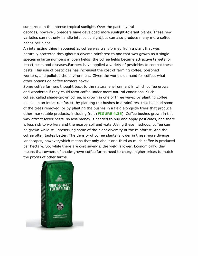
sunburned in the intense tropical sunlight. Over the past several
decades, however, breeders have developed more sunlight-tolerant plants. These new
varieties can not only handle intense sunlight,but can also produce many more coffee
beans per plant.
An interesting thing happened as coffee was transformed from a plant that was
naturally scattered throughout a diverse rainforest to one that was grown as a single
species in large numbers in open fields: the coffee fields became attractive targets for
insect pests and diseases.Farmers have applied a variety of pesticides to combat these
pests. This use of pesticides has increased the cost of farming coffee, poisoned
workers, and polluted the environment. Given the world’s demand for coffee, what
other options do coffee farmers have?
Some coffee farmers thought back to the natural environment in which coffee grows
and wondered if they could farm coffee under more natural conditions. Such
coffee, called shade-grown coffee, is grown in one of three ways: by planting coffee
bushes in an intact rainforest, by planting the bushes in a rainforest that has had some
of the trees removed, or by planting the bushes in a field alongside trees that produce
other marketable products, including fruit (FIGURE 4.36). Coffee bushes grown in this
way attract fewer pests, so less money is needed to buy and apply pesticides, and there
is less risk to workers and the nearby soil and water.Using these methods, coffee can
be grown while still preserving some of the plant diversity of the rainforest. And the
coffee often tastes better. The density of coffee plants is lower in these more diverse
landscapes, however,which means that only about one-third as much coffee is produced
per hectare. So, while there are cost savings, the yield is lower. Economically, this
means that owners of shade-grown coffee farms need to charge higher prices to match
the profits of other farms.
A bird-friendly certification label.
How can farmers producing shade-grown coffee stay in business?A number of
environmental groups that want to preserve biodiversity in tropical rainforests have
stepped in to help.Researchers found that shade-grown coffee farms provided habitat
for approximately 150 species of rainforest birds, whereas open-field coffee farms
provided habitat for only 20 to 50 bird species. Not surprisingly, researchers also found
that other groups of animals were more diverse on shade-grown coffee farms. In
response to these findings, the Smithsonian Migratory Bird Center in
Washington, D.C., developed a program to offer a “Bird Friendly” seal of approval to
coffee farmers who were producing shade-grown coffee. Combined with an advertising
campaign that explained the positive effect of shade-grown coffee on biodiversity,this
seal of approval alerted consumers to make a conscious choice about the impact that
their favorite beverage was having on rainforests. The Arbor Day Foundation, an
environmental organization that promotes the planting of trees, also joined the effort
by selling its own brand of shade-grown coffee.
Perhaps the greatest impact occurred when the Starbucks Coffee Company began
selling shade-grown coffee that received a seal of approval from Conservation
International, another conservation organization. Although it was originally planned as
a short-term offering, customer responses were so positive that the coffee has been
added as a permanent Starbucks product.Over the past 10 years, it has become clear
that when consumers are informed about how coffee is grown, many people are willing
to choose the shade-grown varieties, even if it means spending a bit more money to
reduce their impact on the tropical rainforest biome. References
Philpott, S. M., et al. 2008. Biodiversity loss in Latin American coffee landscapes:Review of the
evidence on ants, birds, and trees. Conservation Biology22:1093−1105.
Smithsonian Migratory Bird Center. Coffee Drinkers and Bird
Lovers.http://nationalzoo.si.edu/ConservationAndScience/MigratoryBirds/Coffee/lover.cfm.
KEY IDEAS REVISITED • Explain the forces that drive global circulation patterns and how those
patterns determine weather and climate.
Global climate patterns are driven by a combination of unequal heating of Earth by the
Sun, atmospheric convection currents, the rotation of Earth and the Coriolis
effect, Earth’s orbit around the Sun on a tilted axis, and ocean currents. The unequal
heating of Earth is the driver of atmospheric convection currents. These air circulation
patterns are further modified by the deflecting action of the Coriolis effect. The tilt of
Earth’s axis of rotation causes seasonal changes in temperature and precipitation as
Earth orbits the Sun. Ocean currents are driven by a combination of
temperature, gravity, prevailing winds, the Coriolis effect, and the locations of
continents. Together, prevailing winds and ocean currents distribute heat and
precipitation around the globe. • Describe the major terrestrial biomes.
Terrestrial biomes are distinguished by a particular combination of average annual
temperature and annual precipitation and by plant growth forms that are adapted to
these conditions. Terrestrial biomes can be broken down into three groups: those in
cold, polar regions with average annual temperatures of less than 5°C (tundra and
boreal forest), those in temperate regions at mid-latitudes that have average annual
temperatures between 5°C and 20°C (temperate rainforest, temperate seasonal
forest,woodland/shrubland, and temperate grassland/cold desert), and those in tropical
regions that have average annual temperatures of more than 20°C(tropical
rainforest, tropical seasonal forest/savanna, and subtropical forest). • Describe the major aquatic biomes.
Aquatic biomes are categorized by their physical characteristics, including
salinity, depth, and water flow. Freshwater aquatic biomes include streams and
rivers, lakes and ponds, and freshwater wetlands. Marine biomes include salt
marshes, mangrove swamps, shallow ocean biomes (intertidal zones and coral
reefs), and the open ocean.
PREPARING FOR THE AP EXAM
MULTIPLE-CHOICE QUESTIONS
[Notes/Highlighting]
1. In which layer of Earth’s atmosphere does most weather occur?
• (a) Troposphere
• (b) Stratosphere
• (c) Mesosphere
• (d) Thermosphere
• (e) Lithosphere [Answer Field]
2. Which of the following best explains why polar regions are colder than tropical
regions?
• (a) Polar regions have lower albedo values.
• (b) Polar regions receive less solar energy per unit of surface area.
• (c) Tropical regions receive less direct sunlight throughout the year.
• (d) Sunlight travels through more atmosphere and loses more energy in tropical
regions.
• (e) Tropical regions rotate at a faster speed than polar regions. [Answer Field]
3. Which of the following statements about patterns of temperature and precipitation
is not correct?
• (a) The air in a Hadley cell rises where sunlight strikes Earth most directly.
• (b) The greatest amount of precipitation occurs at the intertropical convergence
zone.
• (c) The air in a Hadley cell descends near 30° N and S, causing the formation of
deserts.
• (d) The air of a polar cell rises near 60° latitude.
• (e) Along Earth’s surface, the air of a Hadley cell moves toward the equator. [Answer Field]
4. Which of the following processes is not characteristic of oceanic circulation?
• (a) Counterclockwise gyres in the Northern Hemisphere
• (b) Slow thermohaline circulation of surface and deep ocean waters
• (c) Unequal heating of tropical versus polar ocean waters
• (d) El Niño−Southern Oscillation
• (e) Coriolis effect [Answer Field]
5. Which of the following statements about rain shadows is correct?
• (a) They occur on the western sides of mountain ranges in the Northern
Hemisphere.
• (b) Air gains water vapor as it rises.
• (c) As air rises over a mountain range, water vapor condenses into precipitation.
• (d) They occur on the eastern sides of mountain ranges in the Southern
Hemisphere.
• (e) The rain shadow side of a mountain range receives the most rain. [Answer Field]
6. Why do scientists use dominant plant growth forms to categorize terrestrial biomes?
• (a) Plants with similar growth forms are always closely related genetically.
• (b) Different plant growth forms indicate climate differences, whereas different
animal forms do not.
• (c) Plants from similar climates evolve different adaptations.
• (d) Similar plant growth forms are found in climates with similar temperatures
and amounts of precipitation.
• (e) Similar plant growth forms exist in terrestrial and aquatic biomes. [Answer Field]
7. Which information is not found in climate diagrams?
• (a) Average annual temperature
• (b) Seasonal changes in temperature
• (c) Average annual humidity
• (d) The months when plant growth is limited by precipitation
• (e) The length of the growing season [Answer Field]
8. Which of the following statements about tundras and boreal forests iscorrect?
• (a) Both are characterized by slow plant growth, so there is little accumulation of
organic matter.
• (b) Tundras are warmer than boreal forests.
• (c) Boreal forests have shorter growing seasons than tundras.
• (d) Plant growth in both biomes is limited by precipitation.
• (e) Boreal forests have larger dominant plant growth forms than tundras. [Answer Field]
9. Which of the following statements about temperate biomes is not correct?
• (a) Temperate biomes have average annual temperatures above 20°C.
• (b) Temperate rainforests receive the most precipitation, whereas cold deserts
receive the least precipitation.
• (c) Temperate rainforests can be found in the northwestern United States.
• (d) Temperate seasonal forests are characterized by trees that lose their leaves.
• (e) Temperate shrublands are adapted to frequent fires. [Answer Field]
10. Which of the following statements about tropical biomes is correct?
• (a) Tropical seasonal forests are characterized by evergreen trees.
• (b) Tropical rainforests have the highest precipitation due to the proximity of the
ITCZ.
• (c) Savannas are characterized by the densest forests.
• (d) Tropical rainforests have the slowest rates of decomposition due to high
rainfall.
• (e) Subtropical deserts have the highest species diversity. [Answer Field]
11. Which of the following statements about aquatic biomes is correct?
• (a) They are characterized by dominant plant growth forms.
• (b) They can be categorized by temperature and precipitation.
• (c) Lakes contain littoral zones and intertidal zones.
• (d) Freshwater wetlands have emergent plants in their deepest areas,whereas
ponds and lakes do not.
• (e) Coral reefs have the lowest diversity of species.
FREE-RESPONSE QUESTIONS
[Notes/Highlighting]
1. As the greenhouse effect continues to warm the planet slowly, the glaciers of
Greenland are melting at a rapid rate. Scientists are concerned that this melting may
dilute the salt water in that region of the ocean enough to shut down thermohaline
circulation. Use what you know about climate to answer the following questions.
• (a) Explain how shutting down thermohaline circulation would affect the
temperature of western Europe. (2 points)
• (b) Explain the consequences such a temperature change might have for
agriculture in western Europe. (2 points)
• (c) Explain why there would be large populations of fish along the west coasts of
most continents. (3 points)
• (d) Explain how shutting down thermohaline circulation would affect the
transport of nutrients among the oceans of the world. (3 points) [Answer Field]
2. A number of Earth’s features determine the locations of biomes around the world.
• (a) Explain why the regions of the world that receive the most direct sunlight
contain tropical rainforests. (4 points)
• (b) Describe the role that the movement of the ITCZ over the year plays in
creating seasonal forests in tropical regions. (2 points)
• (c) Identify the mechanisms by which albedo and the angle of the Sun’s rays
cause colder temperatures to occur on Earth near the North and South Poles. (2
points for each mechanism)
MEASURING YOUR IMPACT
[Notes/Highlighting]
1. How Much Paper Do You Use? The forested biomes of the world contain dozens of
species of trees that are used for making paper products such as
cardboard, newspaper, tissues, and paper for writing and printing. The average person
in the United States consumes about 300 kg (661 pounds)of paper products per
year, and 30 percent of those products consist of paper for writing and printing.
• (a) How much paper does the average person in the United States use annually
for writing and printing?
• (b) Given that the U.S. population was 308 million people in 2009, how many
kilograms of total paper products are used annually by the U.S.population?
• (c) If the average tree produces 30 kg (66 pounds) of writing and printing
paper, how many trees would be used annually for this paper if all of the paper
came from trees?
• (d) If 50 percent of all writing and printing paper could be made from 100
percent recycled paper, how many fewer trees would be needed for making paper?

• (e) About 18 million students attend college in the United States annually,and
each of these students purchases new textbooks containing an average of 18 kg (40
pounds) of paper each year. If recycled paper is not used to make these
textbooks, how many trees would be consumed annually to make textbooks?