global positioning systems directorate - u.s. coast guard
TRANSCRIPT

Global Positioning Systems Directorate
20 September 2011
GPS Program Update to CGSIC 2011
Col Bernard Gruber Director
GPS Directorate 2011 09 11 GPS Program Update to CGSIC – FINAL4 (3)

2 2011 09 21 GPS Program Update to CGSIC – FINAL4 (3)
Global Positioning Systems Directorate
Mission: Deliver sustained, reliable GPS capabilities to America’s warfighters, our allies and civil users
Col Bernie Gruber
Deliver and Sustain Global Navigation and Timing Service

3 2011 09 21 GPS Program Update to CGSIC – FINAL4 (3)
GPS Constellation • Very robust constellation
• 30 space vehicles currently in operation • 10 GPS IIA, 12 GPS IIR, 7 GPS IIR-M, 1 GPS IIF
• 4 additional satellites in residual status • 1 IIF satellite in test/checkout
• Extensive International and Civil Cooperation • Agreements with 53 international customers • 1+ billion civil/commercial users • Countless applications…and growing
• Global GPS civil service performance commitment met continuously since Dec 1993
4 2011 09 21 GPS Program Update to CGSIC – FINAL4 (3)
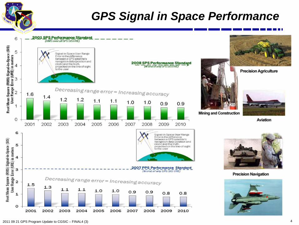
GPS Signal in Space Performance

5 2011 09 21 GPS Program Update to CGSIC – FINAL4 (3)
GPS IIF Status
• Launched GPS IIF-2 on 15 Jul 11 • SVN 63, PRN 1 • Check out phase complete • Second operational L5 • Increases the enhanced GPS clock
performance coverage
• Excellent on-orbit performance • SIS URE of .30 meters (1 yr performance Jul 11)
• 10 more IIFs in the pipeline • SVs 3-6 are in production
• IIF-3 Initial Launch Capability in Feb 12

6 2011 09 21 GPS Program Update to CGSIC – FINAL4 (3)
GPS III Status
• Newest block of GPS satellites • First satellite to broadcast common L1C signal • Multiple civil and military signals; L1 C/A,
L1 P(Y), L1M, L1C, L2C, L2 P(Y), L2M, L5 • Three Rubidium clocks
• Completed Critical Design Review • Completed Independent Program
Assessment (Milestone C) • Prototype and engineering unit build/test underway
• Completed 54 of 59 Manufacturing Readiness Reviews • Completed 32 of 59 Test Readiness Reviews
• GPS Nonflight Satellite Testbed (GNST) started 1 month early • Manufacturing Readiness Review initiated • Completed System Design Review and initiated Capability
Insertion Program for SV-9+

7 2011 09 21 GPS Program Update to CGSIC – FINAL4 (3)
Dual Launch of GPS III Satellites
• Dual launch of GPS III satellites could reduce launch costs of GPS III
• SMC is exploring the technical feasibility and cost implications of dual manifest launch, • Two studies, a space vehicle (SV) study and a launch
vehicle (LV) study, are expected to be complete by Jan 12
• Initial results indicate dual launch on Atlas V possible with minor updates to GPS III and a new dual-payload adapter
Notional Dual Launch
Configuration on Atlas V 551
SV2
SV1

8 2011 09 21 GPS Program Update to CGSIC – FINAL4 (3)
Ground Segment Status
• Current system Operational Control Segment (OCS) • Now flying Block IIA/IIR/IIR-M/IIF constellation • Added the capability for anomaly resolution and disposal ops for IIF
• Next Generation Operational Control System (OCX) Phase B continues on track • Integrated Baseline Review completed August 2010 • Software Specification Review completed September 2010 • Preliminary Design Review July 2011 • Milestone B approval expected 1st Qtr 2012 • OCX Block I deployment planned for 2015
Monitor Station Ground Antenna Master Control Stations at Schriever AFB,
Colorado

9 2011 09 21 GPS Program Update to CGSIC – FINAL4 (3)
• Fourth civil signal “L1C” • Designed for GNSS interoperability • Specification developed in cooperation
with industry • Launches with GPS III in 2014 • Available on 24 SVs ~ 2026* • Improved tracking performance
GPS Modernization – New Civil Signals
• Second civil signal “L2C” • Designed to meet commercial needs • Available since 2005 without data message • Phased roll-out of CNAV message • Full capability: 24 satellites and full CNAV ~2016*
• Third civil signal “L5” • Designed to meet transportation safety-of-life requirements • Uses Aeronautical Radio Navigation Service band • 24 satellites and full CNAV ~2020*
Urban Canyons
Improved performance in
challenged environments
* FOC dates are based on our best estimate of launch schedule

10 2011 09 21 GPS Program Update to CGSIC – FINAL4 (3)
GPS Program Partnership
• Civil representatives integral members of GPS team • Resident in the GPS Directorate – DOT (2), FAA (1), NASA (½)
• Support program, Interface Control Document and Specification reviews • Civil GPS Service Interface Committee (CGSIC) • Signal Monitoring Working Group (SMWG) • Interface Control Working Group (ICWG) • L1C Product Implementation Teams • Positioning Signal Integrity and Continuity
Assurance (PSICA) Team • Interagency Forum for Operational Requirements (IFOR) • National Space-Based PNT Engineering Forum (NPEF)
DOT/FAA team critical to GPS modernization success!

11 2011 09 21 GPS Program Update to CGSIC – FINAL4 (3)
GPS Metrics for Alternatives Assessment
• Performance Metrics generated for multiple constellations • Leveraging existing constellation management tool (GIANT) for our ongoing analysis efforts
• Assessment in terms of GPS User in various scenarios at the Architecture level • 1. Elevation Masking; 2. Jamming; 3. Precision Approach
• Focusing on core metrics associated with: Availability: How often is signal available to the user? Accuracy: What 3-D position accuracy will the user achieve? Robustness: What is the range to denied areas?
GPS Performance Metrics
Scenarios Availability Accuracy Robustness
Elevation Mask (5˚ & 30˚)
NA
Jammer Power (10W, 50W & 100W)
NA
NA
Precision Approach NA NA
Approach provides a more universal way of assessing alternatives

12 2011 09 21 GPS Program Update to CGSIC – FINAL4 (3)
Acquisition Opportunities
• Released GPS Enterprise Modernization Research and Prototype Demonstration “Broad Agency Announcement” – 22 Aug 11 • Soliciting proposals for research and prototypes of GPS capabilities • Released thru Space and Naval Warfare Systems Center, Pacific • Specific areas of interest include:
• Information Assurance • Advanced Integrity • Software Defined Radios • GPS Alternative Architectures
• GPS Systems Engineering & Integration support
• Industry Day held Aug 11 • Refining acquisition strategy • Targeting Industry comments on Draft Request for Proposal (RFP) 1QFY12 • Estimated RFP release in 2QFY12
Resiliency / Affordability

13 2011 09 21 GPS Program Update to CGSIC – FINAL4 (3)
LightSquared (LSQ) Status
• LSQ proposed open wireless broadband network adjacent to GPS L1 • Offering terrestrial 4G service – 34,000+ ATCs across the U.S.A.
• FCC granted conditional waiver to LSQ – 26 Jan 11 • Required LSQ study GPS overload and interference prevention NLT 15 Jun 11
• Supports National Broadband Plan – find 500 MHz for wireless broadband
• Numerous organizations conducted testing - all indicated interference • National Space-Based PNT Engineering Forum Test Report - 1 Jun 11 • Radio Technical Commission for Aeronautics Report - 26 May 11 • Numerous separate filings with FCC by Industry
• LSQ/GPS Industry Council Tech Working Group Report submitted - 30 Jun 11
• LSQ proposing “10 Low” implementation as alternative
• NTIA requesting additional testing be conducted by 30 Nov 11 • Directorate working with DoD and Civil agencies to develop execution plan

14 2011 09 21 GPS Program Update to CGSIC – FINAL4 (3)
Summary
• GPS has continuously met its commitments to all users
• GPS had multiple operational and acquisition successes in the past year
• Modernization of all GPS Segments is on track
• Striving to continually improve navigation and timing services while maintaining backward compatibility with legacy equipment
Maintaining And Improving GPS Services For All Users Is Job #1

15 2011 09 21 GPS Program Update to CGSIC – FINAL4 (3)
Backup
16 2011 09 21 GPS Program Update to CGSIC – FINAL4 (3)
New Certification Paradigm
• 2009 - Receiver problems experienced during segment upgrades • Problems traced to non-ICD compliant User Equipment
• Incorrect implementation/interpretation of interface specifications • Developing DoD “Performance Certification” strategy
• Will determine efficient “Mother of all Test Vector (MTV)” approach to verify Signal-in-Space ICDs
• Final certifying authority will reside either within the directorate or be an independent 3rd party (Underwriter Laboratories construct) organization
• Clarifying business case for both options • Implementing actions
• Seeking stakeholder feedback prior to final ‘certification design’ • Will result in new DoD-Instruction (possibly encompassing both security and
performance certification)
ICD Compliance is Critical for GNSS Success

17 2011 09 21 GPS Program Update to CGSIC – FINAL4 (3)
Military User Segment Status
• Delivered 447,333 GPS handhelds receivers • Accelerated fielding to US + allies (6 months ahead of schedule) • Program transitioning to sustainment
• Fielded over 94,000 embedded GPS military receiver for US and allied nations
• Military GPS User Equipment (MGUE) Program • 3 Prototypes complete; government testing underway • Ongoing ACAT 1D receiver program • Completed MGUE Industry Day

18 2011 09 21 GPS Program Update to CGSIC – FINAL4 (3)
Performance Standard Update
• Planning a draft update of the Open Access Service Performance (OAS PS) Standard by the end of CY11 • Name changed from "Standard Positioning Service Performance Standard"
(SPS PS) • Addition of L2C signal to current L1 C/A signal • Same performance values • Draft update will be circulated for review & comment within U.S. Government • SPS PS update approval before Initial Operational Capability (IOC)
declaration for L2C • Planning subsequent draft updates for L5 signal & for L1C signal
• Prior to each subsequent IOC declaration • Developing an updated set of performance metrics
• Include different user applications and terrain environments