glossary - new jersey · 2017-05-02 · 69 glossary abbreviated report: a report consisting of a...
TRANSCRIPT

69
Glossary
Abbreviated Report: a report consisting of a brief cover letter with appended surveyforms which constitute a regulatory survey for projects of limitedscope. It outlines the details of the project and assesses theproject’s effects on the elements within the Area of PotentialEffect; used when a full report is not necessary because of thelimited scope of a project. This term is used interchangeably with“Letter Report.”
Action: an act or decision by a governmental entity or organization.
Adverse Effect: harm to historic properties, directly or indirectly caused by anaction; adverse effects on historic properties include, but are notlimited to: physical destruction, damage or alteration of all or partof the property; isolation of the property from or alteration of thecharacter of the property’s setting; introduction of visual, audibleor atmospheric elements that are out of character with the prop-erty or that alter its setting; neglect of a property resulting in itsdeterioration or destruction; transfer, lease or sale of the property;see also Effect, Direct Effect and Indirect Effect.
Advisory Council onHistoric Preservation: an independent federal agency that advises the President and
Congress on preservation; the council reviews proposed federalundertakings, including funding or permits, in order to evaluateand mitigate potential effects on historic properties.
Area of PotentialEffects (APE): the geographic area within which an undertaking may cause
changes in the character of or use of historic properties, if anysuch properties exist.
Base Form: the form used in all New Jersey surveys to record basic back-ground and geographical data for all types of properties; the onlyform used in reconnaissance-level surveys; the initial form indocumenting properties in intensive-level surveys.
Base Map: a map that serves as the foundation for identifying and recordinggeographic information and for keying historic resource informa-tion collected as part of a reconnaissance-level or intensive-levelsurvey.
Bay: a vertical division of a building; marked not by walls but byfenestration (columns, buttresses, vaulting, window groupings,etc.).

70
Boundaries: lines which describe the geographical extent or area of an historicproperty or element.
Bridge Attachment Form: the form used only at the intensive-level to document bridges andculverts; always used in conjunction with a Base Form.
Building: a structure created to shelter any form of human activity; ex-amples include a single construction, such as a house, barn,courthouse, city hall, social hall, library, factory, train depot, fort,hotel, theater, school, store, church or jail, as well as a small groupof buildings consisting of a main building and subsidiary buildingsthat are functionally and historically related such as a courthouseand jail, house and barn, mansion and carriage house.
Building/ElementAttachment Form: The form used only at the intensive - level to document build-
ings, sturctures (other than bridges and culverts), or objects;always used in conjunction with a Base Form.
Closed Thematic Survey: a thematic survey whose list of properties is established at theoutset of the survey; see also Thematic Survey.
Condition: the physical state of an element or property, including its level ofrepair and ability to function, not the same as integrity or state ofpreservation; see also State of Preservation and Integrity.
Contributing Element: building, site, structure or object that adds to the historic archi-tectural qualities, historic associations or archaeological values forwhich an historic district is significant because: it was presentduring the period of significance and possesses historic integrityreflecting its character at that time or is capable of yieldingimportant information about the period; or it independentlymeets the National Register criteria.
Determination ofEligibility (DOE): a formal certification issued by the Keeper of the National
Register, National Park Service, Department of the Interior thata district, site, building, structure or object meets the NationalRegister criteria for evaluation although the property is notformally listed on the National Register; properties which receiveDOE’s may subsequently be listed on the National Register.
Direct Effect: effect caused by an undertaking and occurring at the same placeand time; see also Effect.

71
Effect: the result of an action which causes or may cause any change,whether beneficial or adverse, in the quality of the historical,architectural, archaeological or cultural characteristics that quali-fied an historic property to meet the criteria for evaluation for theNew Jersey Register; for the purposes of determining effect,alteration of features of the property’s location, setting or use maybe considered relevant depending on the property’s significantcharacteristics; see also Adverse Effect, Direct Effect and IndirectEffect.
Element: a building, structure or object; individual elements are found on aproperty; an element may also be a site, depending on its sur-roundings; see also Property and Site.
Elevation: 1.) any side of a building other than the front side; or 2.) a drawingof a wall of a building; see also Facade.
Eligibility: ability of a property to meet the criteria for registration at thefederal level (the National Register) or the state level (NewJersey Register); criteria for both identical.
Environment: the physical surroundings of a property or element; also known as“setting.”
Evaluation: the assessment of a property’s eligibility for listing on the NewJersey or National Register.
Facade: the front wall of a building; see also Elevation and PrincipalElevation.
Farm Attachment Form: the form used at the intensive-level which manages the specialdocumentation requirements of an agricultural property; this“umbrella” attachment may be used in conjunction with otherattachments, as appropriate, to thoroughly document the agricul-tural property; always used in conjunction with the Base Form.
Field Work: on site survey activity involving visual and verbal documentationof properties and their settings in the survey area. See also Recor-dation.
Function: the current use of an historic property or element; see also HistoricFunction.

72
Geographic InformationSystem (GIS): a computerized mapping system that can simultaneously manipu-
late both mapped geographic data and data associated withspecific geographic areas.
Global PositioningSystem (GPS): a device which can register a resource’s physical location using
satellite communications.
Historic Context: a method of organizing the significance of a property in termsof chronological time frames, cultural themes (or topics) andgeographical areas; see Section 1.8 of the Guidelines for acomprehensive list of the twelve statewide historic contextswithin which New Jersey history can be analyzed.
Historic District: a geographic area which possesses a significant concentration,linkage, or continuity of sites, buildings, structures, or objectsconnected historically or aesthetically by plan or physicaldevelopment. A historic district conveys its importance as aunified entity even though it is often composed of a wide varietyof resources. Examples of historic districts can include: oneprincipal activity (such as a large industrial facility); a collectionof related activities (such as a downtown commercial area); or acohesive collection of several interrelated activities (such as anentire village or urban neighborhood).
Historic DistrictOverlay Form: the form used only at the intensive-level which groups properties
within the boundaries of an historic district and documentsbackground and basic information on the district as a whole.
Historic Function: the use for which an historic property or element was built orfor which it was used during its period of significance; see alsoFunction.
Historic PreservationFund Grant: a federally funded matching grant from the National Park Service
administered by the State Historic Preservation Office.
Historic Property: any prehistoric or historic district, site, building, structure orobject included in, or eligible for inclusion in, the New Jerseyor National Register; constitutes a single entry in the New Jerseyor National Register.

73
Indirect Effect: effect caused by an undertaking but farther removed in distanceor later in time, but still reasonably foreseeable; examples includechanges in the pattern of land use, population density or growthrate that may affect the quality of the historical, architectural,archaeological or cultural characteristics that qualify a property tobe listed in the New Jersey or National Registers; see also Effect.
Industry Attachment Form: the form used only at the intensive level which documentsthose characteristics which are specific to industrial buildings;may be used in conjunction with other attachments to documentall the elements which contribute to the significance and eligibil-ity of the industrial property; always used in conjunction with theBase Form.
Integrity: the ability of a property or element to convey its historic signifi-cance; the retention of those essential characteristics and featuresthat enable a property to effectively convey its significance.
Intensive-level Survey: a thorough examination of the area being surveyed; designed toidentify precisely and completely all historic elements in the area.
LandscapeAttachment Form: the form used only at the intensive level which documents those
characteristics which are specific to designed landscapes; an“umbrella” attachment which may be used in conjunction withother attachments to document all the elements which contributeto the significance and eligibility of the landscape; always used inconjunction with the Base Form.
Letter Report: a report in the form of a brief cover letter for the forms whichconstitute a regulatory survey, it outlines the details of the projectand assesses the project’s effects on the elements within the Areaof Potential Effect; used when a full report is not necessarybecause of the limited scope of a project; used interchangeablywith Abbreviated Report.
National Historic PreservationAct of 1966, as amended: pivotal preservation legislation with respect to current cultural
resource protection; it established a broad policy of historicpreservation, including the active encouragement of state andlocal efforts; three key components of the NHPA are the NationalRegister of Historic Places, the State Historic Preservation Officeand Section 106; see also National Register of Historic Places,Section 106, Section 110 and State Historic Preservation Office.

74
National RegisterCriteria: criteria used for evaluating the eligibility of properties and
elements for inclusion in the National Register of Historic Places;these include properties and elements that: are associated withevents that have made a significant contribution to the broadpatterns of our history; are associated with the lives of personssignificant in our past; embody the distinctive characteristics of atype, period or method of construction, or that represent asignificant and distinguishable entity whose components maylack individual distinction; have yielded or may be likely to yieldinformation important to prehistory or history.
National Registerof Historic Places: the list of buildings, sites, structures, objects and districts deemed
worthy of preservation based on an analysis of their history andrepresentation of property types important to our history; main-tained by the Keeper of the National Register at the NationalPark Service, Department of the Interior, in Washington, D.C.
New Jersey Register ofHistoric Places: the official list of New Jersey’s historic architectural and archaeo-
logical resources; it is patterned after the National Register ofHistoric Places and both share the same criteria for eligibility,nomination and review process; unlike the National Register, itaccords a degree of protection from state, county or municipalundertakings to State Register properties; also, unlike the Na-tional Register, private owner objection does not prevent designa-tion of properties and only properties actually listed are affordedprotection.
Noncontributing Element: a building, site, structure or object that does not add to the his-toric architectural qualities, historic associations or archaeologicalvalues for which a property is significant because: it was notpresent during the period of significance; due to alterations,disturbances, additions or other changes it no longer possesseshistoric integrity reflecting its character at that time or is inca-pable of yielding important information about the period; it doesnot independently meet the National Register criteria.
Object: construction that is primarily artistic in nature or is relatively smallin scale and simply constructed, as distinguished from a buildingor structure; although it may be movable by nature or design, anobject is associated with a specific setting or environment such asstatuary in a designed landscape; objects should be located in asetting appropriate to their significant historic use, role or charac-ter; examples include, but are not limited to, sculpture, monu-ments, mileposts, boundary markers, statuary, carriage steps,street lighting, and fountains.

75
Open Thematic Survey: a thematic survey whose list of properties is developed throughresearch conducted during the course of the project itself; see alsoThematic Survey.
Project: a planned undertaking; see also Undertaking.
Property: a site or district with its associated setting, which includes subsid-iary buildings, site components, structures or other landscapefeatures, which constitute the property’s elements; a property mayalso be an element depending on its surroundings; see alsoElement and Site.
Property Type: a generic kind of historic property which represents and is definedby an historic context; actual examples of the type may or may notsurvive.
Reconnaissance-Level Survey: a cursory inspection of an area which is most useful for character-
izing the area’s elements in general and for developing a basis fordeciding how to organize and orient more detailed survey efforts.
Recordation: the systematic generation and synthesis of information abouthistoric properties from the properties themselves, by document-ing them on forms and in photographs, thus recording architec-tural elements and surroundings or recording archaeologicaltesting and excavation. See also Field Work.
Section 106: the section of the National Historic Preservation Act, as amended,which initiates a review process by considering the consequencesto historic properties of a federally funded, licensed or permittedundertaking and then progressively narrows the focus untilspecific problems can be identified, understood and resolvedthrough consultation with the HPO and ACHP.
Section 110: the section of the National Historic Preservation Act, as amended,which places additional responsibility on those federal agenciesthat own or control historic resources; these responsibilitiesinclude, among other things: using historic properties to themaximum extent possible; surveying and nominating thoseresources that are eligible for the National Register of HistoricPlaces; considering these resources in the planning process.
Significance: the historical importance or research value of a property to thehistory, architecture, archaeology, engineering or culture of acommunity, state or the nation; significance can be achieved inseveral ways: association with events, activities or patterns;association with important persons; distinctive physical character-istics of design, construction or form; the potential to yield impor-tant information; the area of history in which the property made

76
important contributions; the period of time when these contribu-tions were made.
Site: the location of a significant event, a prehistoric or historicoccupation or activity, or a ruin, where the location itselfmaintains historic or archaeological value regardless of thevalue of any existing structure; examples include, but are notlimited to, habitation sites, funerary sites, rock shelters, villagesites, hunting and fishing sites, ceremonial sites, petroglyphs,rock carvings, battlefields, ruins of historic buildings and struc-tures, campsites, ruins of industrial works, sites of treaty signings,trails, shipwrecks, cemeteries, designed landscape and naturalfeatures such as springs, rock formations and landscapes whichhave cultural significance; depending upon their relationship totheir surroundings, site may be properties or elements; see alsoElement and Property.
State HistoricPreservationOffice (SHPO): the office in state or territorial government that administers the
preservation programs under the National Historic PreservationAct; in New Jersey, the SHPO is the Historic Preservation Office(HPO), Division of Parks and Forests, Department of Environ-mental Protection. The acronym (SHPO) is also used to refer tothe State Historic Preservation Officer, a gubernatorial appointeeresponsible for carrying out the requirements of the NationalHistoric Preservation Act as revised; in New Jersey this is theCommissioner of the Department of Environmental Protection.
State ofPreservation: the degree to which a property’s original materials and workman-
ship have survived; used in the evaluation of integrity.
State Plane Coordinates: coordinates used in GIS mapping for use in defining positions interms of plane-rectangular coordinates; see also GeographicInformation System.
Statement ofSignificance: a concise, well-argued discussion about a property’s eligibility for
the New Jersey or National Register and the property’s integrity;should consist of three parts: a summary paragraph about theproperty’s significance, highlighting specific associations andcharacteristics through which the property has acquired signifi-cance, specific ways the property meets a certain criteria, and therole of important people or cultural affiliations; supporting para-graphs that discuss the history of the property, focusing on thosehistorical associations that make the property eligible for the NewJersey or National Register, presenting the chronological andhistorical developments of the property; and, supporting para-graphs which discuss historic contexts and trends related to theproperty.

77
Story: a horizontal division of a building; the space between the top of afloor and the bottom of the next floor above it.
Structure: a term used to distinguish from buildings those functional con-structions made usually for purposes other than creating shelter;examples include, but are not limited to, bridges, tunnels, golddredges, fire towers, canals, turbines, dams, power plants, corn-cribs, silos, highways, shot towers, windmills, grainelevators, kilns,mounds, cairns, palisade fortifications, earthworks, railroad grades,systems of roadways and paths, boats and ships, railroad locomo-tives and cars, observatories, carousels and aircraft.
Thematic Survey: an architectural survey based on theme or property type; see alsoClosed Thematic Survey and Open Thematic Survey.
Undertaking: an action by the state, a county, municipality or an agency orinstrumentality thereof, which has the potential to result in director indirect effects on any district, site, building, structure or objectlisted in the New Jersey Register; examples include acquisitions,sales, leases, transfers of deed, easements, an agreement or otherform of permission allowing use of a registered property, cyclicalmaintenance and alteration or relocation of a registered property.The following are examples of actions that shall NOT be consid-ered as undertakings: changes in local zoning ordinances; issuanceof building or demolition permits to private individuals or corpora-tions; granting of zoning variance to private individuals or corpora-tions; housekeeping and routine maintenance; see also DirectEffect and Indirect Effect.

Unpublished list compiled byRobert Craig and Richard Porter
1997
Appendix bMap and map
Repositories
81
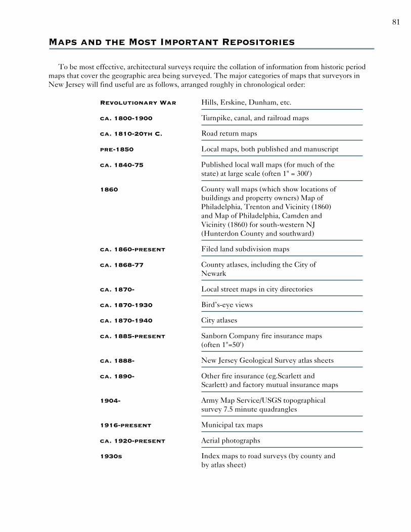
Maps and the Most Important Repositories
To be most effective, architectural surveys require the collation of information from historic periodmaps that cover the geographic area being surveyed. The major categories of maps that surveyors inNew Jersey will find useful are as follows, arranged roughly in chronological order:
Revolutionary War Hills, Erskine, Dunham, etc.
ca. 1800-1900 Turnpike, canal, and railroad maps
ca. 1810-20th C. Road return maps
pre-1850 Local maps, both published and manuscript
ca. 1840-75 Published local wall maps (for much of thestate) at large scale (often 1" = 300')
1860 County wall maps (which show locations ofbuildings and property owners) Map ofPhiladelphia, Trenton and Vicinity (1860)and Map of Philadelphia, Camden andVicinity (1860) for south-western NJ(Hunterdon County and southward)
ca. 1860-present Filed land subdivision maps
ca. 1868-77 County atlases, including the City ofNewark
ca. 1870- Local street maps in city directories
ca. 1870-1930 Bird’s-eye views
ca. 1870-1940 City atlases
ca. 1885-present Sanborn Company fire insurance maps(often 1"=50')
ca. 1888- New Jersey Geological Survey atlas sheets
ca. 1890- Other fire insurance (eg.Scarlett andScarlett) and factory mutual insurance maps
1904- Army Map Service/USGS topographicalsurvey 7.5 minute quadrangles
1916-present Municipal tax maps
ca. 1920-present Aerial photographs
1930s Index maps to road surveys (by county andby atlas sheet)

82
Major Repositories and Principal Placesto Look for Maps
The above maps can usually be found either locally or in one or more of the following major reposito-ries. Local places to look include, but are not necessarily limited to, the local public library, historicalsociety, and municipal or county engineer’s office. Local insurance agencies of long duration sometimeshave acquired useful maps not otherwise easy to find. Surveyors are expected to investigate and uselocal sources of maps, as well as the repositories listed below, when necessary. Use of county publiclibraries and historical societies should also be a regular element of map research.
To gain a better background understanding of New Jersey maps, surveyors should read John W.Snyder, The Mapping of New Jersey (New Brunswick: Rutgers University Press, 1973). For RevolutionaryWar maps, surveyors may also find further help from the specialized works of Peter J. Guthorn onRevolutionary War mapmakers, or from a 2-volume set of reproductions of the Berthier (French) mapscomplied by Howard C. Rice and published by Princeton University Press. For bird’s-eye views, survey-ors may wish to consult John W. Reps, Views and View Makers of Urban America (Columbia, MO: Univer-sity of Missouri Press, 1984), which contains a union list of such views.
New Jersey State Library and Archives, Trenton:
Between the Library and the Archives, many of the important maps can be found.The Archives has some of the most important mid-19th-century county maps eitherin original form or as black-and-white photographic reproductions. The Archives alsoholds the State’s collection of turnpike, canal, and railroad maps, and reproductionsof the Department of Transportation road survey index maps, which occupy two setsof the New Jersey Atlas Sheets (surveyors should be sure to look at both sets). Thelibrary is a place to obtain many of the maps referred to above; it also contains allthree sets of NJ Sanborn maps that have been published on microfilm.
Special Collections & University Archives Division,Alexander Library, Rutgers University, New Brunswick:
“Rutgers Special Collections” contains an outstanding collection of local maps,manuscript and published, and a published index. It also holds reproductions of Hillsand Erskine and other maps of the Revolutionary War. Agnes Grametbaur’s index ofpublished NJ maps, 1800-1949 is available here in hard copy. Probably more of thelarge-scale mid-19th-century wall maps of individual communities are here thananywhere else (and individual maps are being conserved and encapsulated on an on-going basis)
New Jersey Historical Society, Newark:
The Library of the Society holds a large and extremely diverse collection of pub-lished and manuscript maps of New Jersey, with a card index (though the Society’sholding are heavily weighted toward northern New Jersey). Grametbaur’s index isalso here.
Newark Public Library, Newark:
This library, which is known for its extremely large New Jerseyana collections, hasextensive map holdings.

83
County Clerks’ Offices:
The County Clerk’s Office is each county is the principal source of land subdivisionmaps that have been filed since the middle of the 19th century. In some counties,the road return records also include maps of the road returns.
Firestone Library, Princeton University:
The Halliburton Map Room contains a substantial collection of New Jersey maps.Among these are a hard-copy set of Sanborns from the Library of Congress. It isuseful to consult these maps when the Sanborn Company color-coding of a particularfeature must be known.
New Jersey Bureau of Tidelands, Department ofEnvironmental Protection:
This bureau holds the most extensive collection of maps of tideland and coastal areasof New Jersey and the most extensive collection of aerial photographs. It is open toconsultants by appointment only, and some types of searches require payment of afee. Call Mike Ryan for details: (609) 292-2573
New Jersey Department of Transportation, Ewing Township:
This Department holds the state’s archival holdings of highway right-of-way and “as-built” plans, and bridge designs.

Appendix c
Survey FOrms &
Instructions

87
Form Instruction Introduction
The HPO survey forms are designed to collect and organize the information needed to assess theeligibility of historic properties for listing in the New Jersey and National Registers of Historic Places.None of the forms are as detailed as a National Register of Historic Places nomination. Each type ofsurvey form has a set of instructions for its completion, organized according to its data fields. There aredifferent forms available for documenting New Jersey’s districts and properties. The system of formsconsists of a Base Form, Attachments, the Historic District Overlay, and an Eligibilty
Worksheet. Attachments prompt the surveyor to provided information tailored to the evaluation ofparticular elements that make up a property. These form also make the recorded information easilyaccessible and enable the user to group resources into subtypes thereby allowing the development ofspecific contexts for future evaluation. See Section 1.6 of the Architectural Survey Guidelines foradditional information and examples of form usage. The following list provides a brief description ofeach form and how it should be used.
Base Form: This form is used in all surveys to record basic background andgeographical data for all types of properties. For reconnaissance-levelsurveys, this form is the only form used. For intensive-level surveys,this form is the first step in documenting the property.
Historic DistrictOverlay: This form is used only at the intensive level to record basic back-
ground and descriptive information about the historic district. Itdocuments the district as a whole. Properties within the historicdistrict are represented by Base Forms and Attachments, as appropri-ate.
Attachments: Attachments are used only at the intensive level to record specificinformation about specific elements that make up a property. Attach-ments will always refer to the property recorded onthe Base Form. Aproperty may have a variety of elements that relate to its significance,therefore, any number of Attachments may be completed for aparticular property.
For planning surveys: Attachments will be completed for propertiesthat were recommended for further research in the reconnaissance-level report, or properties that would be considered key-contributingproperties in historic districts.
For regulatory surveys: Attachments will be completed for propertiesthat are over fifty years of age and are subject to impacts of an under-taking.
Building/ElementAttachment: This attachment is used only at the intensive level to document the
buildings, structures or objects that make up a property. This attach-ment should always be used in conjunction with a Base Form, andother Attachments as appropriate.

88
Bridge Attachment: This attachment is used only at the intensive level to documentbridges and culverts. This attachment should always be used inconjunction with a Base Form, and other Attachments as appropriate.
LandscapeAttachment: This attachment is used only at the intensive level to document
designed landscapes (versus cultural or traditional landscapes).Designed landscapes may be an element of a larger property (akitchen garden on an estate), or may be the “major element” of theproperty (a large urban park), in which case the form serves to docu-ment the landscape as a whole. Additional elements within thelandscape (bridges, buildings, etc.) should be documented on theirown Attachments. (Cultural or traditional landscapes should berecorded using the Historic District Overlay.)
Farm Attachment: This attachment is used only at the intensive level to documentagricultural complexes. An agricultural complex generally containsmany elements that need to be recorded in order to fully documentthe property, therefore, this attachment serves to describe the com-plex as a whole. Additional elements within the agricultural complex(buildings, barns, bridges etc.) should be documented on their ownAttachments. This Attachment should always be used in conjunctionwith a Base Form, and other Attachments as appropriate.
Industry Attachment: This attachment is used only at the intensive-level to documentindustrial buildings. Each significant industrial building of theproperty should be documented on an Industry Attachment. Addi-tional elements within the industrial complex (non-industrial build-ings, bridges, structures, etc.) and should be documented on theirown Attachments.This Attachment should always be used in con-junction with a Base Form, and other Attachments as appropriate.
Eligibilty Worksheet: This form should be used only at the intensive level to assess eligibil-ity for historic districts or individual properties.
For planning surveys: The Worksheet will be completed for historicdistricts as recorded on the Historic District Overlay, and individualproperties that were recommended for further research in the recon-naissance level report.
For regulatory surveys: The Worksheet will be completed for indi-vidual properties that are over fifty years of age and are subject toimpacts of an undertaking, or historic districts as recorded on theHistoric District Overlay.
Continuation Sheet: This form should be used at the reconnaissance or intensive level toattach additional text, photographs or other illustrations to continueor amplify any survey form or attachment.

89
Base Form Instructions
General Instructions: This form should be used to record basic background and geographi-cal data for surveys. For reconnaissance-level survey, this form is theonly one used to document a property. For intensive-level survey,this form is the first step in documenting the property, and Attach-ments should be competed for specific elements (i.e. buildings,bridges, landscapes). Any and all questions about completing theforms should be directed to the HPO. There are some fields forwhich data lists are provided. In such cases. please choose the mostappropriate word from the supplied list. For information that is notknown, write “unknown” in the appropriate blank. For fields whichare not applicable to the property in question, write “N/A” in theappropriate blank. Continuation sheets may be used for additionaltext, photographs, and other graphics. Multiple responses for a fieldshould be looged on the continuation sheet.
Historic Sites #: This field is for HPO use only.This number is an alphanumeric codeused to uniquely identify all surveyed properties. This number willbe assigned by the HPO once the form is received. For intensive-level surveys, this number will be the same for all attachments.
Surveyor Information: At the bottom of all pages, note the name of the survey, and includethe name(s) of the person(s) completing the form. If two or morepeople were involved in the research and writing, include all names.Include the name(s) of the surveyor, preparer and sponsor, if differ-ent. Also include the date on which the form was completed.
Property Name: Give the common or most descriptive name of the property.
Street Address: Street Address: Please provide the legal address of the propertybeing surveyed. In the near future, addresses will be used to locatesurveyed properties in the HPO’s GIS system, and these fields aredesigned to ensure consistency in specifying this information. When-ever possible, use the official name of the roadway, rather than itsnumeric designation (e.g., use the name “Main” rather than “Route36”). For example, an address such as: “501 East State Street” wouldbe recorded as: LowNumber = 501, Prefix = E, Name = State, andType = ST.
Low Number: Provide the street number of the property. If there isa single number for this property, place it in this field. If there is arange of numbers for the property (e.g., 69-73), place the lowestnumber in this field, and the highest number in the HighNumberfield. This field is restricted to numeric entries.
High Number: If there is a range of numbers for the property (e.g.,69-73), place the highest number in this field. This field is restrictedto numeric entries.

90
Low Apartment: If applicable, provide the apartment number ofthe property. If there is a single number or letter indicating an apart-ment or unit place it in this field (“1” or “A” or “1A” are all validentries). If there is a range of apartment or unit numbers or letters(e.g., 1 through 4 or A through D), place the lowest number or letterin this field, and the highest number or letter in the HighApartmentfield.
High Apartment: If there is a range of apartment or unit numbersor letters (e.g., 1 through 4 or A through D), place the highest numberor letter in this field.
Prefix: This is a restricted data field. If applicable, indicate theprefix associated with the roadway name: N, S, E, W, NW, NE, SW,SE.
Name: Provide the full name of the roadway without any prefixes,suffixes, or type designations. For example, enter “Main” in thisfield. Do NOT enter “S Main St” in this field. The “S” is a prefixand should be entered in the prefix field. The “St.” is a type andshould be entered in the TYPE field. For federal, state or countyhighways, that do not have official names, please use the followingconventions:
For federal highways, write out the name as follows: US Hwy 95For state highways, write out the name as follows: State Hwy 18For county highways, write out the name as follows: County Hwy351
Suffix: This is a restricted data field. If applicable, indicate thesuffix associated with the roadway name: N, S, E, W, NW, NE, SW,SE, EXT.
Type: This is a restricted data field. From the list provided, indicatethe type of roadway:
Avenue AVEBoulevard BLVDCircle CIRCourt CTDrive DRFreeway FWY
Lane LNParkway PKWYPlace PLRamp RAMRoad RDRoute RTE
Street STTerrace TERThoroughfare THFRTurnpike TPKEWay WAY
In a few cases, addresses may be entirely absent. For these unusual cases,please indicate the nearest intersection of two streets. Fill out the followingfields for each of the intersecting streets:
For the first intersecting street:
Prefix1: Defined as above.Name1: Defined as above.Suffix1: Defined as above.Type1: Defined as above.
For the second intersecting street:
Prefix2: Defined as above.Name2: Defined as above.Suffix2: Defined as above.Type2: Defined as above.
County and

91
Municipality: These are restricted data fields. Give the full name of the county andincorporated municipality in which the property is located. If locatedin multiple municipalities (or counties), list all those that apply. Theallowable data can be found in the New Jersey Local Place Nameslist available from the HPO.
Zip Code: Give the postal zip code for the area in which the property is located.
Local Place Name: When applicable, give the local place name in which the property islocated (i.e. Ocean Grove which is in Neptune Township). A list oflocal place names is available from the HPO.
Block: Municipal tax identification number, available from the local taxmaps or tax assessor’s office. List all that apply
Lot: Municipal tax identification number, available from the local taxmaps or tax assessor’s office. List all that apply
Ownership: This is a restricted data field. Indicate whether the property is ownedby a Public, Private, or Non-profit entity.
USGS Quad: This is a restricted data field. From the following list, note the fullname(s) of the United States Geological Survey (USGS) quad onwhich the property appears. List all that apply.
BushkillCaldwellCalifonCamdenCantonCape HenlopenCape MayCassvilleCedarvilleCentral ParkChathamChatsworthChesterClementonColumbusConey IslandCulvers GapDelaware CityDividing CreekDorothyDoverEastonEgg Harbor CityElizabethElmerFarmingdaleFive PointsFlatbrookville
FlemingtonForked RiverFortescueFrankfordFranklinFreeholdFrenchtownGladstoneGreen BankGreenwood LakeHackensackHackettstownHamburgHammontonHeislervilleHigh BridgeHightstownHopewellIndian MillsJamesburgJenkinsJersey CityKeswick GroveKeyportLake MesskenozhaLakehurstLakewoodLambertville
AdelphiaAllentownAllowayArthur KillAsbury ParkAtlantic CityAtsionAvalonBangorBarnegat LightBeach HavenBelvidereBen Davis PointBernardsvilleBeverlyBlairstownBloomsburyBombay HookBoontonBound BrookBranchvilleBridgeportBridgeton( NJ)Brigantine InletBristolBrookvilleBrowns MillsBuena

92
Long BeachLong BranchLumbervilleMarcus HookMarlboroMarmoraMays LandingMedford LakesMendhamMilfordMillvilleMonmouth JunctionMoorestownMorristownMt. HollyNew BrunswickNew EgyptNew GretnaNewfieldNewfoundlandNewton EastNewton WestNewtownvilleNyackOcean CityOceanvilleOrangeOswego LakePark RidgePatersonPemberton
PenningtonPenns GrovePerth AmboyPhiladelphiaPine IslandPitman EastPitman WestPittstownPlainfieldPleasantvillePoint PleasantPompton PlainsPort ElizabethPort Jervis SouthPort NorrisPortlandPrincetonRamseyRaritanRiegelsvilleRio GrandeRocky HillRooseveltRoselleRunnemeadeSalemSandy HookSea Isle CitySeaside ParkShiloh
Ship BottomSloatsburgSouth AmboyStanhopeStocktonStone HarborStroudsburgTaylors BridgeThe NarrowsToms RiverTranquilityTrenton EastTrenton WestTuckahoeTuckertonUnionvilleWanaqueWashingtonWawayandaWeehawkenWest CreekWhitingWildwoodWilliamstownWilmington SouthWoodbineWoodburyWoodmansieWoodstownYonkers
Description: This section should be used to give the reader a clear mental imageof the nature and type of property being surveyed. It should note thebasic form and style of the property as well as any character-definingfeatures. References to materials, construction, and compositionaltechniques should be used whenever possible. This narrative shouldalso elaborate upon significant exterior materials and designs, anddiscuss major alterations and their dates. On-site inspection and/orcomparison with other properties may lead to theories on construc-tion, styles, dates, alterations, etc. If, in the course of a reconnais-sance-level survey, a potential historic district is observed, includethat information in the description (i.e., “surrounding commercialdowntown area has historic district potential”).
Registration andStatus Dates: Provide dates for when all or part of the property was listed on the
New Jersey or National Registers of Historic Places. Also indicate Yesor No if all or part of the property is a National Historic Landmark(NHL). Provide dates if the property has a Determination of Eligibil-ity (DOE) from the Keeper of the National Register, a SHPO Opin-ion, or if the property has been designated historic through a formallocal process. Under “Other”, note the date of when all or part of theproperty was recognized in another way (i.e. listed as historic in acounty-wide survey, municipal master plan, etc.) Dates should beentered in a completely numerical format (i.e.: 04/14/82 not April 14,1982).

93
Photograph: A 35mm 35” x 5” black-and-white or color photograph that gives themost informative view of the property should be attached directly tothe form. Generally, with a free-standing resource, a front and sideview filling 75% of the print is recommended. The image can beeither portrait or landscape orientation in the photograph; however,the photograph must be mounted as indicated on the form (attachportrait oriented photographs with the top to the left). Additionalphotographs may be mounted to continuation sheets.
Location Map: Include a 2´” x 3" map which shows the location of the propertybeing surveyed. The map should be a digital ortho-photo quarterquad, available from NJDEP map scales or a variety of world wideweb sites. USGS topographic maps are acceptable and municipalmaps are also acceptable, provided they show enough context toidentify the location on other map sources. Include a north arrow andbar scale.
Site Map: This map should be included for intensive-level surveys only. Thismap is necessary when there is more than one element per property,and should be used to show the relationship of the elements to eachother (i.e. a house with significant outbuildings as recorded on theBase Form, and Building/Element Attachments. The map should bea municipal tax map or digital ortho-photo quarter quad. Include anorth arrow and bar scale.
Bibliography/Sources: Include citations of research sources consulted regarding theproperty.
Additional Information: Provide any additional information relevant to the property.
For Reconnaissance-Level Survey Only
More Research Needed: Indicate Yes or No to note whether this property warrants furtherresearch at the intensive level based on the initial survey findings.
For Intensive-Level Survey Only
Attachments Included: Indicate the number of additional forms attached to thisBase Form.
Historic Districts: Indicate Yes or No to note whether this property isincouded within the boundaries of an existingor potentialhistoric district.
Name: Indicate the name of the existing or potential historicdistrict that encompasses this property.

94
Key Contributing/Contributing/Non Contributing: Indicate how this property relates to the existing or
potential historic district by checking one of these catego-ries.
Associated ArchaeologicalSite/Deposits: Indicate if there are any known prehistoric or historic
archaeological sites or deposits associated with the prop-erty. If any are known or there is the potential for anassociated site or deposit, please describe.

95

96

97
Building/Element Attachment Form Instructions
General Instructions: This attachment should be used to document individual buildings,structures, and objects for all intensive-level surveys. The type ofelement being documented should be indicated by checking theappropriate box at the top of the form. Only one building, structureor object should be documented on each attachment form. Additionalattachments should be completed for other significant elements thatmake up the property. (Questions about completing the forms shouldbe directed to the HPO.) There are some fields for which data listsare provided. In such cases, please choose the most appropriate wordfrom the supplied list. For information that is not known, write“unknown” in the appropriate blank. Some fields on the Building/Element Attachment apply only to buildings or structures, indicatedby “B” (Building) or “S” (Structure) following the field name. Con-tinuation sheets may be used for additional text, photographs, andother graphics. Multiple responses for a field should be listed on thecontinuation sheet.
Building/Structure/Object: Check only one box at the top of the attachment to indicated what
type of element is being surveyed. See Sections 2.1.3 or 3.1.3 of theArchitectural Survey Guidelines for definitions of these categories.
Historic Sites #: This field is for HPO use only. This number is an alphanumeric codeused to uniquely identify all surveyed properties. This number willbe assigned by the HPO once the form is received. This number willbe the same as assigned on the base form.
SurveyorInformation: At the bottom of all pages, note the name of the survey, and include
the name(s) of the person(s) completing the form. If two or morepeople were involved in the research and writing, include all names.Include the name(s) of the surveyor, preparer and sponsor, if differ-ent. Also include the date on which the form was completed.
Common Name: A descriptive name, name of the current owner or occupant, or streetaddress, or combination thereof may be listed under common name.Some elements are known by compound names and should be soidentified.
Historic Name: The historic name could be the earliest known name, the name ofthe original owner, the name of the most significant occupant, or theelement’s most significant use. If several historic names are known,use the one most closely associated with the most salient aspects ofits history.

98
Present Use: This is a restricted data field. Indicate the primary present use of theelement by choosing the most appropriate activity from the list thatfollows. The list provided corresponds to the “Land Use ActivityClassification” of the American Planning Association’s draft LandBased Classification Standards. Examples are provided in parenthe-ses for clarification only, and should not be entered on the form.
➤ Residential Activity
Permanent (single family, multi family etc.)Transient, nonfamily (hotels, motels, etc.)Transient, institutional (dorms, rehabs, etc.)
➤ Commercial Activity
Shopping (retail)Standalone (Single store)Malls and shopping centersPersonal ServicesEating, DrinkingOffice activity - private businessOffice activity - public, governmental
➤ Industrial activity
Research and developmentLight industrialHeavy industrialHeavy goods handling and processing
➤ Transportation andMovement Activity
Pedestrian movementVehicular movementVehicular parkingPassenger assembly
➤ Mass assembly
SportsMoviesConcerts, fairs, etc.
➤ Institutional Activities
Educational activity (schools)Government ServicesPublic Safety activities (fire, EMS, etc.)Public utility services (landfills, waterworks, etc.)Prison and jailReligious activity (non residential)
➤ Recreational andentertainment activity
Active recreation - outdoor (ball fields, etc.)Active recreation - indoor (health clubs, gyms, etc.)Passive recreation - outdoor (parks)Passive recreation - indoor (casinos)
➤ No activity
➤ Unclassifiable Activities
Historic Use: This is a restricted data field. Indicate the primary historic use of theelement by choosing the most appropriate activity from the listabove. The list provided corresponds to the “Land Use ActivityClassification” of the American Planning Association’s draft LandBased Classification Standards. Examples are provided in parenthe-ses for clarification only, and need not be entered on the form.

99
Construction Dateand Source: If known, please indicate the exact date of construction (i.e. 1943 or
1842-43). If the exact date is not known, give the construction dateby circa date. Source of date (i.e. 1859 and 1876 maps, stylisticevidence, cornerstone) should be cited.
Alteration Date(s) andSource: If known, please indicate the exact date of all significant alterations
(i.e. 1943 or 1842-43). If the exact date is not known, give the alter-ation date by circa date. Source of date (i.e. 1859 and 1876 maps,stylistic evidence, corner-stone) should be cited.
Designer: Give the name of the primary individual or firm (architect, engineer,artist, etc..)responsible for designing the element.
Builder: When appropriate, also indicate the name of the primary individualor company responsible forconstructing the building or structure.
Style: This is a restricted data field. If applicable, choose one of the follow-ing architectural styles which most closely describes the element. Ifthe element embodies more than one style, choose the most pre-dominant and include the others in the exterior description. Fordefinitions of the following terms, consult the suggested readings inSection 4 of the Architectural Survey Guidelines. If the element is avernacular adaptation of a popular style, enter the name of the stylefollowed by the word “vernacular” (i.e. Federal, vernacular).
Adirondack RusticAmerican RenaissanceArt ModerneArt DecoBeaux ArtsBrutalismChateauesqueColonialColonial RevivalCraftsmanDeconstructivistDutch Colonial RevivalDutch ColonialEastlake
Egyptian RevivalFederalFrench EclecticGeorgianGeorgian RevivalGothic RevivalGreek RevivalItalian RenaissanceItalianateModernisticNew FormalismNoneOctagonPost-Medieval English
Post-ModernPrairieQueen AnneRenaissance RevivalRichardsonian RomanesqueRomanesque RevivalSecond EmpireShingleSpanish Colonial RevivalStickSullivanesqueTudor RevivalWrightianOther
Physical Condition: This is a restricted data field. Based on an inspection of the exterior,this refers solely to the physical condition of the element, not itsarchitectural integrity or extent of alterations.
Excellent: No visible repair work neededGood: Need for general maintenanceFair: In need of more than routine maintenancePoor: In need of major repairs

100
Remaining HistoricFabric: This is a restricted data field. Using the three choices, indicate
whether the building or structure retains a High, Medium, or Lowamount of its original historic fabric. This estimate, based on visualobservation and/or archival research, includes materials, finishes,details, and any character-defining features.
Form: This is a restricted data field. If applicable, choose one of the follow-ing building forms which most closely describes the building. If thebuilding embodies more than one form, choose the most predomi-nant and include the others in the exterior description. For defini-tions of the following terms,consult the suggested readings in Section4 of the Architectural Survey Guidelines.
Berry DrierCarriage HouseCisternCorncribDutch BarnEnglish/Three Bay BarnErie Shore BarnGarageGazeboGerman/Pennsylvania BarnGranary
GreenhouseHay BarrackHog HouseMilk HouseOctagonal/Polygonal BarnPoultry House/
Chicken CoopPower HousePrivyRoot CellarRound Barn
ShedSiloSmokehouseSpringhouseThree Gable BarnTransverse Frame BarnWindmillWisconsin Dairy BarnWorker HousingOther
2/3 GeorgianApartmentBig Box RetailBungalowCape CodCenter HallCommercialDeep East Jersey CottageDouble PileDouble PenDuplexE-Plan
East Jersey CottageFour SquareFour-over-FourGable FrontGable EllH-planHipped EllI-HouseIrregularOctagonPyramidalQuonset Hut
RanchRowSaltboxSemi-DetachedShotgunSide HallSingle PenSkyscraperSplit LevelU-PlanOther
Type: This is a restricted data field. Referring primarily to outbuildings orother secondary buildings,choose one of the following building typeswhich most closely describes the building. If the building or struc-ture embodies more than one type, choose the most predominantand include others in the exterior description.
Stories: If applicable, indicate the number of stories (vertical levels) in thebuilding.
Bays : If applicable, indicate the number of bays (horizontal fenestration onthe facade) in the building.

101
Exterior FinishMaterials: This is a restricted data field. If applicable, choose one of the follow-
ing materials to indicate the most prominent exterior finish. If thebuilding has more than one type of exterior material, choose the mostimportant or most represented on the primary facade, and include theothers in the exterior description.
Roof FinishMaterials: This is a restricted data field. If applicable, choose one of the follow-
ing materials to indicate the most prominent roof finish. If thebuilding has more than one type of roofing material, choose the mostpredominant one and include the others in the description.
ExteriorDescription: This section should be used to give the reader a clear mental image
of the nature and type of element being surveyed. It should note thebasic form and style of the element as well as any character-definingfeatures. References to materials, construction, and compositionaltechniques should be used whenever possible. This should alsoelaborate upon all significant exterior materials and designs, anddiscuss major alterations and their dates. On-site inspection and/orcomparison with other elements may lead to theories on construction,styles, dates, alterations, etc. Do not repeat here if the description isthe same as that outlined on the Base Form.
Aluminum SidingAsbestos SidingAsphalt ShingleBrick, Header BondBrick, Running BondBrick, Flemish BondBrick, English BondBrick, Common BondCast IronCast StoneConcreteConcrete Block, RusticatedConcrete Block, ModernCorrugated SteelFiberglassGlass, Carrara
Glass, Curtain WallGlass, BlockHomasoteInsulbrickPermastonePorcelain-Enameled SteelPressed MetalSheet AluminumStainless SteelStone, RubbleStone, Coursed RubbleStone, AshlarStone, Random AshlarStone, VermiculatedStone, CobblestoneStucco
Terra CottaVinyl SidingWood, OtherWood, ClapboardWood, ShiplapWood, PlywoodWood, Bead BoardWood, LogWood, PlankWood, Half TimberedWood, Shaped ShinglesWood, Board and BattenWood, FlushWood, ShinglesOther
Asbestos ShingleAsphalt ShingleBuilt-up TarCold MembraneCopperCrushed AggregateFlat Seam Metal
GlassMetalRolled AsphaltRubber MembraneSlateStanding Seam MetalTile, Roman
Tile, ConcreteTile, SpanishTinUnknownWood, ShakeWood, ShingleOther

102
Interior Description: Interior descriptions should be provided for significant and accessibleinteriors of publicly-owned, and when appropriate, privately-ownedbuildings or structures. This section should also be used to give thereader a clear mental image of the nature and type of interior beingsurveyed. It should discuss the building’s interior features includingfinishes and decor.This narrative should also elaborate upon signifi-cant interior materials and designs, and discuss major alterations andtheir dates. References to materials, construction, and compositionaltechniques should be used whenever possible. On-site inspectionand/or comparison with other buildings may lead to theories onconstruction, styles, dates, alterations, etc.
Setting: Setting is the location and environment of the element and itsrelationship to its surroundings (both natural and manmade). Indicatethe approximate size and nature of the element and the location ofrelated elements. Explain the relationships between the element andrelated transportation routes and surrounding landscape.

103

105
Bridge Attachment Form Instructions
General Instructions: This attachment should be used to document bridges for all inten-sive-level surveys. (Questions about completing the forms should bedirected to the HPO.) There are some fields for which data lists areprovided. In such cases, please choose the most appropriate wordfrom the supplied list. For information that is not known, write“unknown” in the appropriate blank. Continuation sheets may beused for additional text, photographs, and other graphics. Multipleresponses for a field should be listed on the continuation sheet.
Historic Sites #: This field is for HPO use only. This number is an alphanumeric codeused to uniquely identify all surveyed properties. This number willbe assigned by the HPO once the form is received. For intensive-level surveys, this number will be the same as assigned on the baseform.
Surveyor Information: At the bottom of all pages, note the name of the survey, and includethe name(s) of the person(s) completing the form. If two or morepeople were involved in the research and writing, include all names.Include the name(s) of the surveyor, preparer and sponsor, if differ-ent. Also include the date on which the form was completed.
Common Name: Provide the common name of the bridge.
Historic Name: If applicable, provide the historic name of the bridge.
Feature Carried: Give the name of the feature that the bridge carries (i.e. “New JerseyTransit Morristown Line” or “Route 526”)
Feature Crossed: Give name of the feature that the bridge intersects or spans (i.e.“Delaware River”)
Milepost: This number usually only applies to railroad bridges. Give themilepost number of the bridge.
Owner/Operator: This is a restricted data field. Choose one of the following owner/operators:
Conrail Port AuthorityCounty PrivateMunicipal UnknownNJ Transit OtherNJDOT
SI&A Sturcture Number: This number applies only to bridges on the Federal Inspection Plan.Provide the seven-digit Federal Structure Inventory and AppraisalNumber.

106
Design: This is a restricted data field. Choose one of the following bridgedesigns which most accurately describes the bridge being surveyed.If one or more of the designs apply, choose the most predominantand discuss the others in the description.
If Then Choose
arch bridge parabolic, round, or segmental
swing bridge center-bearing or rim-bearing
bascule bridge Strauss Heel Trunnion, Overhead Strauss,Strauss Underneath, Scherzer Rolling Lift, orRall Rolling Lift
verticallift bridge Waddell or Strauss
any type oftruss bridge Pratt, Baltimore, Warren, Pratt Half-Hip,
Pennsylvania, Lenticular, Double-IntersectionWarren, Double-IntersectionPratt, Parker, Howe, or Other
Construction Dateand Source: If known, please indicate the exact date of construction (i.e. 1943 or
1842-43). Ifthe exact date is not known, give the construction date bycirca date. Source of date (i.e. 1859 and 1876 maps, stylistic evidence,data plate) should be cited.
Alteration Date(s): If known, please indicate the exact date of all significant alterations(i.e. 1943 or 1842-43). If the exact date is not known, give the alter-ation date by circa date. Source of date (i.e. 1859 and 1876 maps,stylistic evidence, data plate) should be cited.
Engineer: Give the name of the primary individual or firm responsible fordesigning the bridge.
Builder: When appropriate, give the name of the primary individual or com-pany responsible for constructing the bridge.
Type: This is a restricted data field. Choose one of the following bridgetypes which most accurately describes the bridge being surveyed. Ifone or more types apply, choose the most predominant and discussthe others in the description.
ArchCable-StayedDeck TrussGirder, DeckGirder, ContinuousGirder, Through
Moveable, BasculeMoveable, SwingMoveable, Vertical LiftPontoonRigid FrameSlab
StringerSuspensionT-BeamTruss, ThroughTruss, PonyOther
Material: This is a restricted data field. Choose one of the following materialsto indicate the most prominent material. If the bridge has more than

107
one type of material, choose the most predominant one andinclude the others in the description.
Brick SteelCast Iron WoodConcrete Wrought IronSteel
Physical Condition: This is a restricted data field. Based on an inspection of the structure,this refers solely to the physical condition of the bridge, not itsarchitectural integrity or extent of alterations.
Excellent: No visible repair work neededGood: Need for general maintenanceFair: In need of more than routine maintenancePoor: In need of major repairs
Remaining Historic Fabric: This is a restricted data field. Using the three choices, indicatewhether the bridgeretains a High, Medium, or Low amount of itsoriginal historic fabric. This estimate, based on visual observationand/or archival research, includes materials, finishes, details,and any character-defining features.
Spans: Give the total number of spans which comprise the bridge. A span isthe distance between the supports of the bridge.
Length: Give the length of the bridge, in feet, from abutment to abutment.
Width: Give the width of the bridge, in feet (A measure of width perpen-dicular to the span noted above).
Patent Holder andDate of Issue: If applicable, give the original U.S. or International patent number
for the bridge and the date of issue.
Description: This section should be used to give the reader a clear mental imageof the nature and type of bridge being surveyed. It should note thebasic type and design of the bridge as well as any character-definingfeatures. References to materials, construction, and compositionaltechniques should be used whenever possible. This narrative shouldalso elaborate upon all significant materials and designs, and discussmajor alterations and their dates. On-site inspection and/or compari-son with other bridges may lead to theories on construction, styles,dates, alterations, etc.
Setting: Setting is the location and environment of the bridge and its relation-ship to its surroundings (both natural and manmade). Indicate theapproximate size and nature of the bridge and the location of relatedelements. Explain the relationships between the bridge and relatedstructures, transportation routes, and surrounding landscape.

108

109
Landscape Attachment Form Instructions
General Instructions: This attachment should be used to document designed landscapes(versus cultural or natural landscapes) for all intensive-level surveys.Landscapes may be an element of a larger property (kitchen gardenof an estate) or may be the “major element” of the property (largeurban park). Additional attachments should be included for othersignificant elements that make up the property.(Questions aboutcompleting the forms should be directed to the HPO.) There aresome fields for which data lists are provided. In such cases, pleasechoose the most appropriate word from the supplied list. For infor-mation that is not known, write “unknown” in the appropriate blank.Continuation sheets may be used for additional text, photographs,and other graphics. Multiple responses for a field should be listed onthe continuation sheet.
Historic Sites #: This field is for HPO use only. This number is an alphanumeric codeused to uniquely identify all surveyed properties. This number willbe assigned by the HPO once the form is received. This number willbe the same as assigned on the base form.
Surveyor Information: At the bottom of all pages, note the name of the survey, and includethe name(s) of the person(s) completing the form. If two or morepeople were involved in the research and writing, include all names.Include the name(s) of the surveyor, preparer and sponsor, if differ-ent. Also include the date on which the form was completed.
Common Name: A descriptive name, name of the current owner, or street address, orcombination thereof, may be listed under common name. Somelandscapes are known by compound names and should be so identi-fied.
Historic Name: The historic name could be the earliest known name, the name ofthe original owner, or the property’s most significant use. If severalhistoric names are known, use the one most closely associated withthe most salient aspects of its history.
Present Use: This is a restricted data field. Indicate the primary present use of thelandscape by choosing the most appropriate activity from the list thatfollows. The list provided corresponds to the “Land Use ActivityClassification” of the American Planning Association’s draft LandBased Classification Standards. Examples are provided in parenthe-ses for clarification only, and need not be entered on the form.

110
➤ Residential Activity
Permanent (single family, multi family etc.)Transient, nonfamily (hotels, motels, etc.)Transient, institutional (dorms, rehabs, etc.)
➤ Commercial Activity
Shopping (retail)Standalone (Single store)Malls and shopping centers
Personal ServicesEating, DrinkingOffice activity - private businessOffice activity - public, governmental
➤ Industrial activity
Research and developmentLight industrialHeavy industrialHeavy goods handling and processing
➤ Transportation and Movement Activity
Pedestrian movementVehicular movementVehicular parkingPassenger assembly
➤ Mass assembly
SportsMoviesConcerts, fairs, etc.
➤ Institutional Activities
Educational activity (schools)Government ServicesPublic Safety activities (fire, EMS, etc.)Public utility services (landfills, waterworks, etc.)Prison and jailReligious activity (non residential)
➤ Recreational and entertainment activity
Active recreation - outdoor (ball fields, etc.)Active recreation - indoor (health clubs, gyms, etc.)Passive recreation - outdoor (parks)Passive recreation - indoor (casinos)
➤ No activity
➤ Unclassifiable Activities
Historic Use: This is a restricted data field. Indicate the primary historic use of thelandscape by choosing the most appropriate activity from the listabove. The list provided corresponds to the “Land Use ActivityClassification” of the American Planning Association’s draft LandBased Classification Standards. Examples are provided in parenthe-ses for clarification only, and need not be entered on the form.
Construction Dateand Source: If known, please indicate the exact date of the landscape’s construc-
tion (i.e. 1943 or 1842-43). If the exact date is not known, give theconstruction date by circa date. Source of date (i.e. 1859 and 1876maps, stylistic evidence, other documentation) should be cited.
Alteration Date(s)and Source: If known, please indicate the exact date of all significant alterations
to the landscape (i.e. 1943 or 1842-43). If the exact date is not known,give the alteration date by circa date. Source of date (i.e. 1859 and1876 maps, stylistic evidence, other documentation) should be cited.
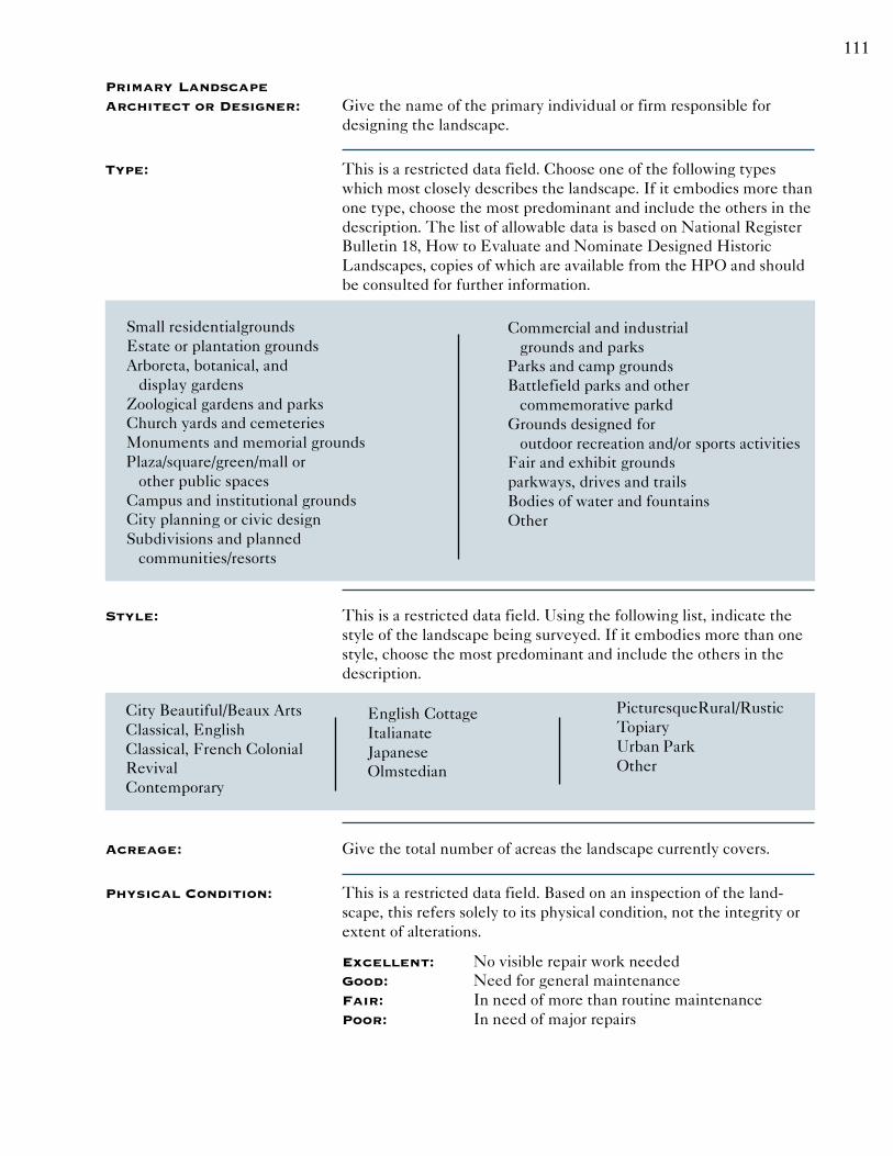
111
Primary LandscapeArchitect or Designer: Give the name of the primary individual or firm responsible for
designing the landscape.
Type: This is a restricted data field. Choose one of the following typeswhich most closely describes the landscape. If it embodies more thanone type, choose the most predominant and include the others in thedescription. The list of allowable data is based on National RegisterBulletin 18, How to Evaluate and Nominate Designed HistoricLandscapes, copies of which are available from the HPO and shouldbe consulted for further information.
Small residentialgroundsEstate or plantation groundsArboreta, botanical, and display gardensZoological gardens and parksChurch yards and cemeteriesMonuments and memorial groundsPlaza/square/green/mall or other public spacesCampus and institutional groundsCity planning or civic designSubdivisions and planned communities/resorts
Commercial and industrial grounds and parksParks and camp groundsBattlefield parks and other commemorative parkdGrounds designed for outdoor recreation and/or sports activitiesFair and exhibit groundsparkways, drives and trailsBodies of water and fountainsOther
Style: This is a restricted data field. Using the following list, indicate thestyle of the landscape being surveyed. If it embodies more than onestyle, choose the most predominant and include the others in thedescription.
City Beautiful/Beaux ArtsClassical, EnglishClassical, French ColonialRevivalContemporary
PicturesqueRural/RusticTopiaryUrban ParkOther
Acreage: Give the total number of acreas the landscape currently covers.
Physical Condition: This is a restricted data field. Based on an inspection of the land-scape, this refers solely to its physical condition, not the integrity orextent of alterations.
Excellent: No visible repair work neededGood: Need for general maintenanceFair: In need of more than routine maintenancePoor: In need of major repairs
English CottageItalianateJapaneseOlmstedian

112
Remaining Historic Fabric: This is a restricted data field. Using the three choices, indicatewhether the landscape retains a High, Medium, or Low amount of itsoriginal historic fabric. This estimate, based on visual observationand/or archival research, includes materials, details, and any charac-ter-defining features.
Hardscape: This is a restricted data field. Choose from the following materials toindicate the most prominent type of hardscape within the landscape.If it has more than one type of hardscape material, choose the mostpredominant one and include the others in the description.
Driveways, GravelDriveways, EarthDriveways, AsphaltDriveways, Poured ConcreteDriveways, Stone
Driveways, BrickWalkways, StoneWalkways, EarthWalkways, AsphaltWalkways, Cast Concrete
Walkways, Poured ConcreteWalkways, BrickWalkways, GravelOther
Plantings: This is a restricted data field. Choose from the following types ofplantings to indicate the most prominent type within the landscape.If it has more than one type of planting material, choose the mostpredominant one and include the others in the description.
Other Features: This is a restricted data field. Choose from the following types offeatures to indicate the most prominent type within the landscape. Ifit has more than one type of feature, choose the most predominantone and include the others in the description.
Description: Surveyors should refer to National Register Bulletin 18, How toEvaluate and Nominate Designed Historic Landscapes, U.S. Depart-ment of the Interior, National Park Service, Interagency ResourcesDivision. This bulletin outlines research and documentation require-ments for evaluating designed landscapes. Generally, the followingcategories of information should be included: property boundaries; allstructures on the property; fences, walls, and elements of enclosure;walks, driveways, and all other pavement; posts, bollards, poles;plants and vegetation; all other specific features such as remnants ofold foundations, manmade riprapping, arbors, trellises, curbing; siteobservations; views and vistas, within and outside of theboundaries; utilities; all natural features.
Fruit TreesMature Hardwoods
Planted BedsShrubbery
Other
BenchesFences, StoneFences, IronFences, SteelFences, Brick
Fences, WoodFountainGazeboPergolaPonds
Retaining WallsSculptureWaterfallOther

113
Setting: Setting is the location and environment of the landscape and itsrelationship to its surrounding areas. Indicate the approximate sizeand nature of the landscape and the locations of all related elements.Explain the relationships between the landscape and related trans-portation routes and surrounding areas.

114

115
Farm Attachment Form Instructions
General Instructions: This attachment should be used to document farm complexes for allintensive-level surveys. Please note that this attachment considersthe farm as a whole, and should refer to the entire historic property asdescribed on the Base Form. Additional attachments should beincluded for other significant elements (farmhouse, barns, etc.) thatmake up the property (Questions about completing the forms shouldbe directed to the HPO.) There are some fields for which data listsare provided. In such cases, please choose the most appropriate wordfrom the supplied list. For information that is not known, write“unknown” in the appropriate blank. Continuation sheets may beused for additional text, photographs, and other graphics. Multipleresponses for a field should be listed on the continuation sheet.
Historic Sites #: This field is for HPO use only. This number is an alphanumeric codeused to uniquely identify all surveyed properties. This numberwill be assigned by the HPO once the form is received. For inten-sive-level surveys, this number will be the same as assigned on thebase form.
Surveyor Information: At the bottom of all pages, note the name of the survey, and includethe name(s) of the person(s) completing the form. If two or morepeople were involved in the research and writing, include all names.Include the name(s) of the surveyor, preparer and sponsor, if differ-ent. Also include the date on which the form was completed.
Common Name: A descriptive name, name of the current owner, or street address maybe listed under common name. Some agricultural complexes areknown by compound names and should be so identified.
Historic Name: The historic name could be the earliest known name, the name ofthe original owner, the name of the most significant occupant, or thecomplex’s most significant use. If several historic names areknown, use the one most closely associated with the most salientaspects of its history.
Period of AgriculturalUse and Source: If known, please give the period of time for which the complex has
been used for agricultural purposes. Source of information (i.e.personal interview with owner or local historian) must be cited.

116
Agriculture Type: This is a restricted data field. Using the following list, indicate whattype of agricultural complex is being surveyed. If the complexembodies more than one type, choose the most predominant andinclude the others in the description. The list of allowable data isadapted from the 1997 North American Industy Classification System(NAICS).
Oilseed and grain farmingVegetable and
melon farmingFruit and tree nut farmingGreenhouse, nursery
& floriculture production
Other crop farmingCattle ranching and farmingHog and Pig farmingPoultry and egg productionSheep and goat farmingAnimal aquaculture
Other animal productionForestry and loggingFishing, hunting
and trapping
Physical Condition: Based on an general inspection of the complex, this refers solely tothe overall physical condition of all its features, not their architecturalintegrity or extent of alterations.
Excellent: No visible repair work neededGood: Need for general maintenanceFair: In need of more than routine maintenancePoor: In need of major repairs
Remaining Historic Fabric: Indicate whether the complex retains a High, Medium, or Lowamount of its original historic fabric. This estimate, based on visualobservation and/or archival research, includes architectural or engi-neering elements, landscapes, and any character defining features.
Acreage: Give the total number of acres the farm currently covers.
Description: This section should be used to give the reader a clear mental imageof the nature and type of agricultural complex being surveyed. Itshould note its basic type and layout as well as any character-definingfeatures. References to materials, construction, and compositionaltechniques should be used whenever possible. This narrative shouldalso elaborate upon all significant exterior materials and designs,and discuss major alterations and their dates. On-site inspection and/or comparison with other complexes may lead to theories on con-struction, styles, dates, alterations, etc.
Setting: Setting is the location and environment of the complex and itsrelationship to its surroundings (both natural and manmade). Indicatethe approximate size and nature of the complex and the location ofrelated structures. Explain the relationships between the complexand related transportation routes and surrounding landscape. Identifyand provide a rationale for all boundaries.

117

119
Industry Attachment Form Instructions
General Instructions: This attachment should be used to document industrial buildings forall intensive-level surveys. This attachment focuses on the specificbuildings within the industrial property. Additional attachmentsshould be included for other significant elements (structures, bridges,etc.) that make up the property (Questions about completing theforms should be directed to the HPO.) There are some fields forwhich data lists are provided. In such cases, please choose the mostappropriate word from the supplied list. For information that is notknown, write “unknown” in the appropriate blank. Continuationsheets may be used for additional text, photographs, and othergraphics. Multiple responses for a field should be listed on thecontinuation sheet.
Historic Sites #: This field is for HPO use only. This number is an alphanumeric codeused to uniquely identify all surveyed properties. This number willbe assigned by the HPO once the form is received. This number willbe the same as assigned on the base form.
Surveyor Information: At the bottom of all pages, note the name of the survey, and includethe name(s) of the person(s) completing the form. If two or morepeople were involved in the research and writing, include all names.Include the name(s) of the surveyor, preparer and sponsor, if differ-ent. Also include the date on which the form was completed.
Common Name: A descriptive name, name of the current owner or occupant, or streetaddress, or combination thereof, may be listed under common name.Some industrial properties are known by compound names andshould be so identified.
Historic Name: The historic name could be the earliest known name, the name ofthe original owner, the name of the most significant occupant, or theproperty’s most significant use. If several historic names are known,use the one most closely associated with the most salient aspects ofits history.
Present Use: This is a restricted data field. If the industrial building does not retainan industrial use, indicate the primary present use of the industrialbuilding by choosing the most appropriate activity from the list thatfollows. The list provided corresponds to the “Land Use ActivityClassification” of the American Planning Association’s draft LandBased Classification Standards. Examples are provided in parenthe-ses for clarification only, and need not be entered on the form. If thebuilding does retain an industrial use, refer to the list that followsHistoric Industry, which is adapted from “Engineering and IndustrialStructures Classification” by HAER, copies of which are availablefrom the HPO and can be consulted for further information.

120
➤ Residential Activity
Permanent (single family, multi family etc.)Transient, nonfamily (hotels, motels, etc.)Transient, institutional (dorms, rehabs, etc.)
➤ Commercial Activity
Shopping (retail)Standalone (Single store)Malls and shopping centers
Personal ServicesEating, DrinkingOffice activity - private businessOffice activity - public, governmental
➤ Industrial activity
(refer to the list thatfollows Historic Industry)
➤ Transportation andMovement Activity
Pedestrian movementVehicular movementVehicular parkingPassenger assembly
➤ Mass assembly
SportsMoviesConcerts, fairs, etc.
➤ Institutional Activities
Educational activity (schools)Government ServicesPublic Safety activities (fire, EMS, etc.)Public utility services (landfills, waterworks, etc.)Prison and jail
➤ Recreational andentertainment activity
Active recreation - outdoor (ball fields, etc.)Active recreation - indoor (health clubs, gyms, etc.)Passive recreation - outdoor (parks)Passive recreation - indoor (casinos)
➤ No activity
➤ Unclassifiable Activities
Historic Industry: This is a restricted data field. From the list that follows, provide thehistoric (original) industrial use of the element. The list of allowabledata is adapted from “Engineering and Industrial Structures Classifi-cation” by HAER. Copies of which are available from the HPO andcan be consulted for further information. Examples are provided inparentheses for clarification only, and should not be entered on theform.
Iron MiningNon-Metallic Mineral Extraction
(Stone, Gravel, Minerals)Non-Ferrous Ore Extraction
(Copper, Zinc, Lead)Other Extraction
Brick & Structural Clay WorksPottery & Ceramic WorksGlass WorksCement PlantsCharcoal KilnsLime KilnsOther Thermally Produced Products
Plastics & SyntheticsPharmaceuticalsSoaps, Detergents, & Animal ProductsPaints and Varnishes
Petroleum ProductsOther Chemical Industry
Meat, Fish, & Poultry ProcessingDairies and BakeriesGrain and Cereal ProcessingSugar RefiningBreweries, Distilleries, & Bottling PlantsFood Preservation (refrigeration and canning)
Iron FurnacesNon-ferrous Metal Smelters & RefineriesFoundries and Casting WorksRolling, Drawing, and Extruding Works
Textiles, Spinning or WeavingTextiles, Finishing (printing or dyeing, etc.)Twine, Cordage, Netting, and Bagging

121
Other Textile Industry
LoggingMillwork, Veneer, Plywood & other
Wood ProductsPaper MakingSawmills and/or Planing Mills
Machine Manufacture (All types)Fabricated Metal Products ManufactureTransportation Equipment Manufacture
Instrument Manufacture(Professional, scientific, and precision)
Publishing and Allied IndustriesRubber Products Manufacture
Leather and Other Animal SkinProducts Manufacture
Ordnance, Munitions, andExplosives Manufacture
Finished Wooden Product Manufacture(furniture, spools, barrels, baskets, etc.)
Other General Manufacturing
Municipal Water Supply UtilitiesSanitation UtilitiesGas UtilitiesElectrical Utilities
Telephone and Telegraph CommunicationsRadio and Television Communications
Building ID: This field should be completed when the industrial building beingsurveyed has an identification number or letter to distinguish indi-vidual buildings and structures within the complex. If applicable,indicate the number or letter of the building being documented.
Construction Dateand Source: If known, please indicate the exact date of the industrial building
construction (i.e. 1943 or 1842-43). If the exact date is not known,give the construction date by circa date. Source of date (i.e. 1859 and1876 maps, stylistic evidence, cornerstone) should be cited.
Alteration Date(s)and Source: If known, please indicate the exact date of all significant alterations
to the industrial building (i.e. 1943 or 1842-43). If the exact date is notknown, give the alteration date by circa date. Source of date (i.e. 1859and 1876 maps, stylistic evidence, cornerstone) should be cited.
Architect: Give the name of the primary individual or firm responsible fordesigning the industrial building.
Builder: When appropriate, also indicate the name of the primary individual orcompany responsible for constructing the industrial building.
Style: This is a restricted data field. If applicable, choose one of the follow-ing architectural styles which mostclosely describes the industrialbuilding. If the building embodies more than one style, choose themost predominant and include the others in the exterior description.For definitions of the following terms, consult the suggested readingsin Section 4 of the Architectural Survey Guidelines. If the property isa vernacular adaptation of a popular style, enter the name of the stylefollowed by the word “vernacular” (i.e. Federal, vernacular).

122
Adirondack RusticAmerican RenaissanceArt ModerneArt DecoBeaux ArtsBrutalismChateauesqueColonial RevivalCraftsmanDeconstructivistDutch ColonialDutch Colonial RevivalEastlakeEgyptian RevivalFederalFrench EclecticGeorgianGeorgian RevivalGothic RevivalGreek RevivalInternational
Italian RenaissanceItalianateModernisticNew FormalismNoneOctagonPost-Medieval EnglishPost-ModernPrairieQueen AnneRenaissance RevivalRichardsonian RomanesqueRomanesque RevivalSecond EmpireShingleSpanish Colonial RevivalStickSullivanesqueTudor RevivalWrightianOther
Physical Condition: This is a restricted data field. Based on an inspection of the exterior,this refers solely to the physical condition of the industrial building,not its architectural integrity or extent of alterations.
Excellent: No visible repair work neededGood: Need for general maintenanceFair: In need of more than routine maintenancePoor: In need of major repairs
Remaining Historic Fabric: This is a restricted data field. Using the three choices, indicatewhether the building retains a High, Medium, or Low amount of itsoriginal historic fabric. This includes materials, finishes, details,and any character-defining features.
Length and Width: Give the length and width of the industrial building, in feet, fromouter wall to outer wall.
Stories: If applicable, indicate the number of stories (vertical levels) in theindustrial building.
Bays: If applicable, indicate the number of bays (horizontal fenestration onthe facade) in the industrial building.
Exterior Finish Materials: This is a restricted data field. Choose one of the following materialsto indicate the most prominent exterior finish. If the industrialbuilding has more than one type of exterior material, choose the mostpredominant one and include the others in the exterior description.

123
Aluminum SidingAsbestos SidingAsphalt ShingleBrick, Header BondBrick, Running BondBrick, Flemish BondBrick, English BondBrick, Common BondCast IronCast StoneConcreteConcrete Block, RusticatedConcrete Block, ModernCorrugated SteelFiberglassGlass, CarraraGlass, Curtain WallGlass, BlockHomasoteInsulbrickPermastonePorcelain-Enameled SteelPressed Metal
Sheet AluminumStainless SteelStone, RubbleStone, Coursed RubbleStone, AshlarStone, Random AshlarStone, VermiculatedStone, CobblestoneStuccoTerra CottaVinyl SidingWood, OtherWood, ClapboardWood, ShiplapWood, PlywoodWood, Bead BoardWood, LogWood, PlankWood, Half TimberedWood, Shaped ShinglesWood, Board and BattenWood, Flush
Foundation Materials: This is a restricted data field. Choose one of the following materialsto indicate the most prominent foundation material. If the industrialbuilding has more than one type of foundation material, choose themost predominant one and include the others in the exteriordescription.
Brick, Common BondBrick, English BondBrick, Flemish BondBrick, Header BondBrick, Running BondCast StoneConcrete Block, RusticatedConcrete Block
Modern ConcreteStone, CobblestoneStone, VermiculatedStone, Random AshlarStone, AshlarStone, Coursed RubbleStone, RubbleOther
Structural System: Indicate the type of structural system (i.e. load-bearing walls) used inthe industrial building.
Roof System: Indicate the type of roofing system (i.e. metal truss) is used in theindustrial building.
Roof Finish Materials: This is a restricted data field. Choose one of the following materialsto indicate the most prominent roof finish. If the industrial buildinghas more than one type of roofing material, choose the most predomi-nant one and include the others in the description.

124
Asbestos ShingleAsphalt ShingleBuilt-up TarCold MembraneCopperCrushed AggregateFlat Seam MetalGlassMetalRolled AsphaltRubber Membrane
SlateStanding SeamTile, RomanTile, ConcreteTile, SpanishTinWood, ShakeWood, ShingleOtherUnknown
Equipment/Machinery: Indicate the presence of significant equipment and/or machineryused in theindustrial building and note predominant types or charac-teristics. Include power sources if known, as well as processes andother equipment.
Transportation Links: This is a restricted data field. Choose one or more of the followingtransportation links which service(d) the industrial property.
AirstripDockLoading Dock
Rail SidingSlipOther
Description: This section should be used to give the reader a clear mental imageof the nature and type of industrial building being surveyed. Itshould note its basic form and style as well as any character-definingfeatures, such as roof shape, door and window types, and fenestrationpatterns. References to materials, construction, and compositionaltechniques should be used whenever possible. This narrative shouldalsoelaborate upon all significant materials and designs, and discussmajor alterations and their dates. On-site inspection and/or compari-son with other buildings may lead to theories on construction, styles,dates, alterations, etc. When possible and applicable, include adescription of the interior space and the type of machinery usedwithin the building.
Setting: Setting is the location and environment of the buildingt and itsrelationship to its surroundings (both natural and manmade). Indi-cate the approximate size and nature of the building and the locationof related elements. Explain the relationships between the industrialbuilding and related structures, transportation routes, and surround-ing landscape.

125

127
Historic District Overlay Form Instructions
General Instructions: This attachment should be used to document historic districts for allintensive-level surveys. For Planning Surveys, Base Forms and theirAttachments should be included for each individually eligible or keycontributing property within the district boundaries. For regulatorysurveys, Base Forms and their attachments should be included for allproperties within that portion of the historic district that is within theAPE. (Questions about completing the forms should be directed tothe HPO.) There are some fields for which data lists are provided. Insuch cases, please choose the most appropriate word from the sup-plied list. For information that is not known, write “unknown” in theappropriate blank. Continuation sheets may be used for additionaltext, photographs, and other graphics. Multiple responses for a fieldshould be listed on the continuation sheet.
Historic Sites #: This field is for HPO use only. This number is an alphanumeric codeused to uniquely identify all surveyed districts or properties. Thisnumber will be assigned by the HPO once the form is received. Thisnumber will be different than those assigned on attached BaseForms.
Surveyor Information: At the bottom of all pages, note the name of the survey, and includethe name(s) of the person(s) completing the form. If two or morepeople were involved in the research and writing, include all names.Include the name(s) of the surveyor, preparer and sponsor, if differ-ent. Also include the date on which the form was completed.
District Name: This name of the district could be the historic name or commonname. The name may reflect its earliest known name, a local placename, natural feature, geographical location, or locallandmark.
District Type: This is a restricted data field. Choose one or more of the followingtypes of historic districts to describe the area being surveyed:
AgriculturalCommercialIndustrial
ResidentialTransportationOther
County and Municipality: These are restricted data fields. Give the full name of the county andincorporated municipality in which the property is located. If locatedin multiple municipalities (or counties), list all those that apply. Theallowable data can be found in the New Jersey Local Place Nameslist available from the HPO.
Local Place Name: When applicable, give the local place name in which the property islocated (i.e. Ocean Grove which is in Neptune Township). A list oflocal place names is available from the HPO.

128
USGS Quad: This is a restricted data field. Using the following list, note the fullname(s) of the United States Geological Survey (USGS) quad onwhich the site appears. List all that apply.
AdelphiaAllentownAllowayArthur KillAsbury ParkAtlantic CityAtsionAvalonBangorBarnegat LightBeach HavenBelvidereBen Davis PointBernardsvilleBeverlyBlairstownBloomsburyBombay HookBoontonBound BrookBranchvilleBridgeportBridgeton( NJ)Brigantine InletBristolBrooklynBrookvilleBrowns MillsBuckinghamBuenaBushkillCaldwellCalifonCamdenCantonCape HenlopenCape MayCassvilleCedarvilleCentral ParkChathamChatsworthChesterClementonColumbusConey Island
Culvers GapDelaware CityDividing CreekDorothyDoverEastonEgg Harbor CityElizabethElmerFarmingdaleFistbrookvilleFlatbrookvilleFive PointsFlemingtonForked RiverFortescueFrankfordFranklinFreeholdFrenchtownGladstoneGreen BankGreenwood LakeHackensackHackettstownHamburgHammontonHatboroHeislervilleHigh BridgeHightstownHopewellIndian MillsJamesburgJenkinsJersey CityKeswick GroveKeyportLakeMesskenozhaLakehurstLakewoodLambertvilleLanghorneLong BeachLong BranchLumberville
Marcus HookMarlboroMarmoraMays LandingMedford LakesMendhamMilfordMillvilleMonument JunctionMoorestownMorristownMt. HollyNew EgyptNew BrunswickNew GretnaNewfieldNewfoundlandNewtown WestNewtown EastNewtownvilleNyackOcean CityOceanvilleOrangeOswego LakePark RidgePattersonPembertonPenningtonPenns GrovePerth AmboyPhiladelphiaPine IslandPitman WestPitman EastPittstownPlainfieldPleasantvillePoint PleasantPomptonPlainsPort NorrisPort Jervis SouthPort ElizabethPortlandPrincetonRamsey

129
RaritanRiegelsvilleRio GrandeRocky HillRooseveltRoselleRunnemeadeSalemSandy HookSea Isle CitySeaside ParkShilohShip BottomSloatsburg
South AmboyStanhopeStocktonStone HarborStroudsburgTaylor BridgeThe NarrowsToms RiverTranquilityTrenton EastTrenton WestTuckahoeTuckertonUnionville
WanaqueWashingtonWawayandaWeehawkenWest CreekWhitingWildwoodWilliamstownWilmington So.WoodbineWoodburyWoodmansieWoodstownYonkers
Development Periodand Source: Provide the main period(s) of development of the historic district by
decade. Source of date(s) (i.e. 1859 and 1876 maps, stylistic evidence)should be cited.
Physical Condition: This is a restricted data field. Based on an general inspection, thisrefers solely to the physical condition of the properties in the districtas a whole, not their integrity or extent of alterations.
Excellent: No visible repair work neededGood: Need for general maintenanceFair: In need of more than routine maintenancePoor: In need of major repairs
Remaining HistoricFabric: This is a restricted data field. Using the three choices indicate
whether the district retains a High, Medium, or Low amount of itsoriginal historic fabric. This estimate, based on visual observation and/or archival research, includes materials, finishes, details, and anycharacter-defining features.
Registration andStatus Dates: Provide dates for when all or part of the historic district was listed on
the New Jersey or National Registers of Historic Places. Also indicateYes or No if all or part of the district is a National Historic Landmark(NHL). Provide dates if the district has a Determination of Eligibility(DOE) from the Keeper of the National Register, a SHPO Opinion, orif the district has been designated historic through a formal localprocess. Under “Other”, note the date of when all or part of theproperty was recognized in another way (i.e. listed as historic in acounty-wide survey, municipal master plan, etc.) Dates should beentered in a completely numerical format (i.e.: 04/14/82 not April 14,1982).

130
Description: Give a general physical description of the district, including majorstreets and overall setting. Include a detailed discussion of thesurrounding environment. Describe general building types andarchitectural styles represented and comment upon the essentialcharacter, scale, materials, variety, or homogeneity within the district.Comment upon original, as well as present, appearance, if known.Indicate both outstanding structures and intrusions. Significantobjects or structures which contribute the overall character of thedistrict (i.e. street furniture, signage, tree canopies) should be in-cluded.
Setting: Setting is the location and environment of the district and its rela-tionship to its surroundings (both natural and manmade). Indicate theapproximate size and nature of the district. Explain the relationshipsbetween the district as a whole and related transportation routes andsurrounding landscape.

131
133
Eligibility Worksheet Form Instructions
General Instructions: This attachment should be used to assess eligibility for historicdistricts or individual properties for all intensive-level surveys. Theworksheet should be attached to the Base Form or to the HistoricDistrict Overlay for the property or district in question. (Questionsabout completing the forms should be directed to the HPO.) Thereare some fields for which data lists are provided. In such cases, pleasechoose the most appropriate word from the supplied list. For infor-mation that is not known, write “unknown” in the appropriate blank.Continuation sheets may be used for additional text, photographs,and other graphics. Multiple responses for a field should be listed onthe continuation sheet.
Historic Sites #: This number is an alphanumeric code used to uniquely identify allsurveyed historic districts or properties. This number will be assignedby the HPO once the form is received.
Surveyor Information: At the bottom of all pages, note the name of the survey, and includethe name(s) of the person(s) completing the form. If two or morepeople were involved in the research and writing, include all names.Include the name(s) of the surveyor, preparer and sponsor, if differ-ent. Also include the date on which the form was completed.
History: Provide a concise factual history of the district or property beingsurveyed. The history should relate directly to the district or prop-erty; do not include an elaborate history of the area unrelated to thesurviving built environment. The narrative should offer not only thehistory of the district or property, but also any historic contexts intowhich the district or property fits. A list of historic contexts availablefrom the HPO can be found in Section 1.8 of the ArchitecturalSurvey Guidelines.
Statement ofSignificance: This field should be completed to aid in determining eligibility for
the New Jersey and national Registers. Significance is placing thehistorical facts of the district or property into an historic context anddetermining whether the district or property is a physical representa-tion of an important aspect of the past. Generally, the discussionshould focus on the historical, architectural, archaeological, or envi-ronmental reasons for including it in the inventory. Indicate whetherthe district or property is rare or representative of the region.
Eligibility for New Jerseyand National Registers: Using your judgment and based on available information, indicate
your opinion as to the eligibility of the district or property.

134
National RegisterCriteria: If the district or property is evaluated as eligible, indicate under
which of the National Register Criteria or Criteria Considerations itwould fall. National Register Criteria and Criteria Considerations canbe found in National Register Bulletin 15: How to Apply the Na-tional Register Criteria for Evaluation, U.S. Department of theInterior, National Park Service, Interagency Resources Division.
Level Of Significance: Indicate if the district or property is significant at the Local, State,and/or National levels.
For Individual Properties Only
Justification ofEligibility/Ineligibility: Briefly state why the district or property should or should not be
considered eligible for the New Jersey or National Registers (i.e.Rare or representative example or loss of integrity).
For Historic Districts Only
Property Count: Indicate numerically how many key-contributing and non-contribut-ing properties are located within the boundaries of the property orhistoric district. See National Register Bulletin 14: Guidelines for Count-ing Contributing and Non-Contributing Resources for National RegisterDocumentation for additional information regarding counting re-sources.
NarrativeBoundary Description: Provide a complete description of the boundaries of the property or
historic district. Include all relevant landmarks and features, andprovide justification for the boundaries.
For Individual Properties Only
List of Attachments: In the space provided, list the completed attachments that relate tothe significance of the property being documented. Attachmentsshould be listed by the name of the element documented on theattachment.

135
137
Continuation Sheet Form Instructions
General Instructions: This form should be used to attach additional text, photographs, orother illustrations to continue or amplify any survey form for allintensive-level regulatory and planning (HPF or other) surveys.Please indicate the form and field to which the additional informationrefers.
Historic Sites #: This number is an alphanumeric code used to uniquely identify allsurveyed historic districts or properties. This number will be assignedby the HPO once the form is received.
Surveyor Information: At the bottom of all pages, note the name of the survey, and includethe name(s) of the person(s) completing the form. If two or morepeople were involved in the research and writing, include all names.Include the name(s) of the surveyor, preparer and sponsor, if differ-ent. Also include the date on which the form was completed.

138

139
NOTES

140
NOTES

141
NOTES

142
NOTES