golder associates ltd. - british...
TRANSCRIPT
Golder Associates Ltd.
100· 388 First Avenue Kamloops, British Columbia, Canado V2C 6W3 Telephone (250) 828·6116 Fax (250) 828·1215
May 25 , 1998
Slocan Forest Products Ltd. c/o Kamloops Region Ministry of Forests 515 Columbia Street Kamloops, B.C. V2C2T7
ATTENTION: Mr. Tim Giles. P.Geo.
Our ref: 972-3139
RE: CLEARWATER - VA VENBY COMMUNITY WATERSHEDS TERRAIN STABILITY MAPPING - FRBC PROJECT # T097360S, CLEARWATER FOREST DISTRICT
Dear Sirs:
Please find enclosed a document package relating to the above-noted project. Could you please forward the documents to the appropriate agencies, including Ms. Rowena Bryan ofSlocan Forest Products Ltd., Vavenby Division. The attachments include:
• One set of typed airphotos for the study area. The terrain mapping is marked directly onto the photos and includes material type, slope range, drainage class, and interpretations for slope stability, erosion potential and sediment transfer potential.
• Five copies of the report (four bound copies and one unbound copy). • I :20,000 scale terrain and derivative maps of the project area (4 sets). • One copy of the field cards and notes taken during our field reconnaissance. The
information from these forms is summarized in the attached report and on the maps. The originals will be retained by Golder in our project files .
Should you have any questions or comments regarding the above information, please do not hesitate to contact us.
Yours truly,
GOLDER ASSOCIATE§. ,I,;Tm~-_ ...
~ ,.;:J . ...:--~,~ •• . /~Ii-:;"·c~)j~\
• G . .I.~ ~ . \. \( "":;;'; '-7 I
" •. ,. l' G R 'd PEg " ' " ,... . ,' reg el , . n . ~ (.i\_ .... .-- -;t.,'
Senior Geologic;l Enginee}ari'd~~~;ewer d:lwordI972·3 139.cJ6
OFFICES IN AUSTRALIA. CANADA, GERMANY, HUNGARY, ITALY. SWEDEN. UNITED KINGDOM. UNITED STATES
Slocan Forest Products Ltd. Clearwater/Vavenby Terrain Mapping
1.0 INTRODUCTION
-1-March, 1998
972-3139
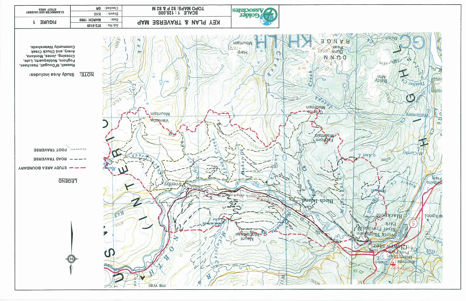
This report accompanies a set of Terrain Maps and Derivative Maps produced as a result of detailed terrain stability mapping at terrain survey intensity level (TSIL) C for 11 community watersheds in the Clearwater Forest District. The maps pertain to a 33,120 ha portion of the North Thompson valley between Clearwater and Vavenby, B.C. and include the following adjoining basins:
• Foghorn Creek watershed (2,989 ha), south side of North Thompson valley, • Avery Creek watershed (1,879 ha), south side of North Thompson valley, • Jones Creek watershed (3,956 ha), south side of North Thompson valley, • Crossing Creek watershed (4,490 ha), north side of N Thompson valley, • Noblequartz Creek watershed (2,543 ha), north side of N Thompson valley, • Lute Creek watershed (2,776 ha), south side of North Thompson valley, • Chuck Creek watershed (5,720 ha), south side of North Thompson valley, • Russell Creek watershed (l,882 ha), south side of North Thompson valley, • Haschaek Creek watershed (606 ha), south side of North Thompson valley, • McDougal Creek watershed (3,832 ha), south side of North Thompson valley, • Montana Creek watershed (2,447 ha), north side of N Thompson valley.
The locations of the study areas are shown on Figure 1, attached. The work was conducted by Golder Associates Ltd. in association with KDW Geographic Solutions Ltd. on behalf of Slocan Forest Products Ltd., Vavenby Division, and funded by FRBC. Terrain mapping and interpretations for slope stability, erosion potential and sediment transfer potential were carried out according to provincial standards (see Section 2 - Methods). Terrain mapping was carried out on 1995 series 1: 15 000 scale colour airphotos by a combination of airphoto interpretation and field checking. Original mapped photos and field notes have been retained by the Kamloops Region Ministry of Forests for archiving.
This report outlines the mapping methodology followed and criteria developed for slope stability and other interpretations in the project area (Section 2). COlnments regarding map reliability and project constraints are also included in Section 2. Section 3 contains a general overview of the study area. Sections 4 and 5 sumlnarize information about surficial materials and processes identified during the course of mapping. The final section contains a brief discussion of the nature and extent of apparent terrain hazards present in the study area.
Golder Associates
Slocan Forest Products Ltd. Clearwater/Vavenby Terrain Mapping
2.0 METHODS
2.1 Terrain Mappine
-2-March, 1998
972-3139
Terrain mapping followed the standard British Columbia procedures for terrain classification (Howes and Kenk, 1997), mapping methods (RIC, 1995) and 5-class stability mapping (Forest Practices Code, 1995).
Terrain mapping was conducted by Ms. Carrie-Lynn Brown, G.I.T., and Ms. Tracey Feeney, G.I.T., with senior review and project management carried out by Mr. Greg Reid, P. Eng. Field checks were performed to verify preliminary mapping and, where necessary, guide revisions to the preliminary work. The bulk of the field checking was completed during October, 1997, with some supplementary work completed in late November, 1997, during which a total of 34 crew days were spent in the project area. The work involved traversing representative polygons of the various surficial materials and slopes within operable and potentially operable forest areas. Attention was focused on those relatively steeper slopes likely to be designated as stability Class IV or V and other potentially sensitive areas.
In general, road access was adequate throughout the entire study area, with the exception of some of the privately held land in the valley bottom. Russell and Haschaek watersheds were essentially inaccessible by road with the exception of one small area in the center of the Russell Creek watershed. The various watersheds comprising the map area were traversed in the field by a combination of road and foot traverses, with supplementary visual observations made during a brief helicopter overflight. In general, the traverses were planned to provide representative coverage across representative terrain in all of the map area, while focusing on potentially operable regions with steeper slopes and areas of potential instability. Soil pits were dug on occasion where natural exposures, slide scars or tree-throw hollows were not available for observation.
Table 1: Airphotos
Project Flight Line Photo Numbers Photo Numbers Nl BCC95116 #108-125 N2 BCC95119 #176-195 N3 BCC95116 #043-061 N4 BCC95119 #007-029 N5 BCC95116 #026-042 (west) BCC95118 #132-137 (east) N6 BCC95118 #100-122 N7 BCC95118 #010-031
Golder Associates
Slocan Forest Products Ltd. Clearwater/Vavenby Terrain Mapping -3-
March, 1998 972-3139
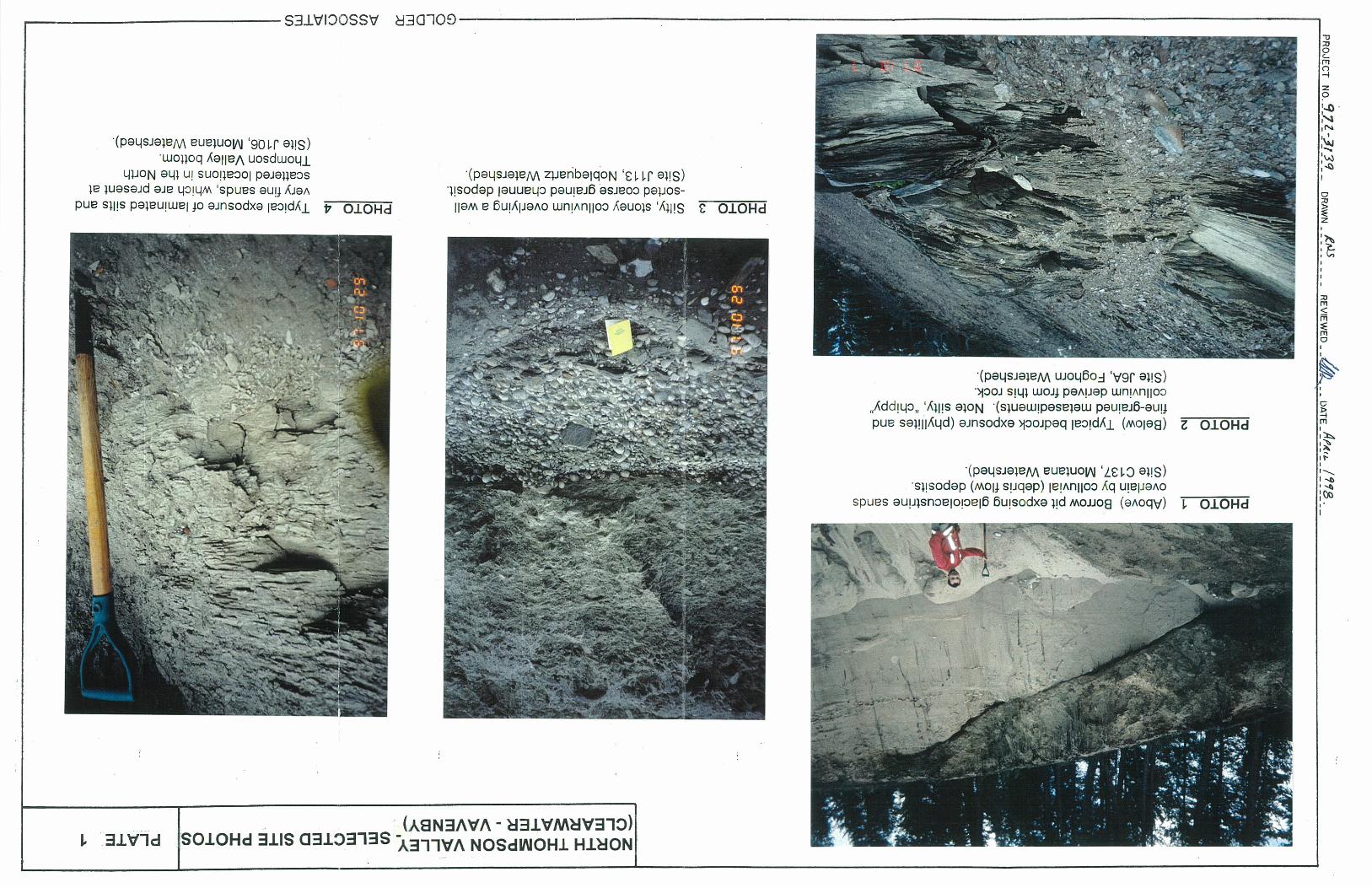
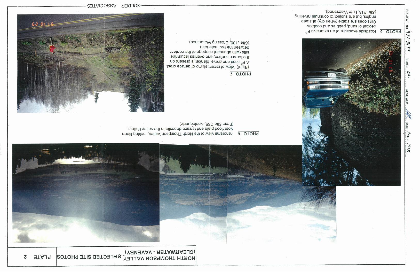
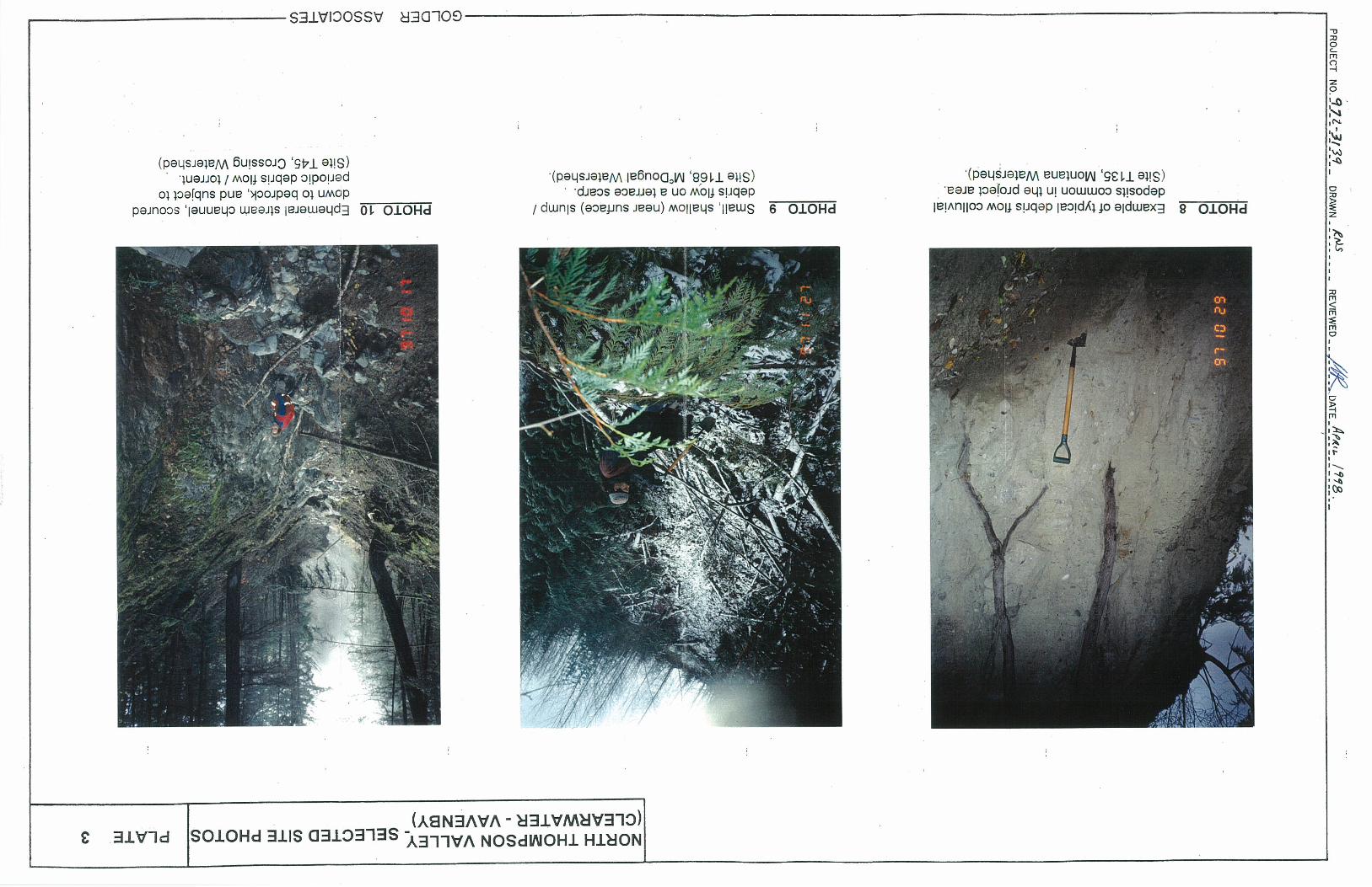
All field observation site locations are shown on the airphotos and maps. Observations made at each ground inspection site include slope gradient and contiguration, aspect, soil drainage and other moisture indicators, surticial material type and texture; and terrain stability, erosion potential, and sediment transfer potential ratings. At many sites where good soil exposures were available, photographs were taken of representative materials or terrain features. Selected photos are attached in Appendix 1.
On completion of the field work, both linework and symbols on the mapped airphotos were revised to reflect the field observations made, and ratings for erosion potential and sediment transfer potential were added. Please note that on the photos only, slope steepness is indicated both by classes and percentages (the classes represent areas where slope determination is based largely on the I :20,000 scale TRIM topography, and percentages where representative field measurements were made). On the maps, slope range is indicated in percent (as per RIC standards). A comparison of map and field measurements suggests that topographic maps are generally reliable for this purpose on a regional scale, but on a local scale, small areas in some polygons may not be clearly represented by contours. This project has been completed subject to the FRBC quality assurance review process, and where appropriate the reviewers' comments have been incorporated into the mapping and interpretations.
Terrain polygon boundaries and field check sites mapped on every second photo, have been transferred to map form by a digital monorestitution process. On-site symbols relevant to slope stability interpretation and geomorphological processes (e.g., landslide headscarps and meltwater channels) have also been identified on the photos and digitized. A database containing the polygon labels was also prepared (in the form of an Excel spreadsheet) for transfer of the polygon label information into electronic format.
2.2 Terrain Assessment Criteria
As part of this project, three attributes of each terrain polygon unit, namely terrain stability, erosion potential and sediment transfer potential, have been assigned a rating. Each rating applied by the mapper is an interpretation of the relative intensity of the attribute, based on the combination of site factors present in the terrain polygon, using a set of defined criteria as guidelines. Users should note that there is no single set of quantitative definitions for any of the terrain attributes which applies to all areas of British Columbia, due to the wide variation in precipitation, aspect, and soil and bedrock conditions across the Province. For example, slope stability classes may vary from region to region in terms of the typical slope steepness, soil moisture, material type etc., which comprise a particular class.
Golder Associates
Slocan Forest Products Ltd. Clearwater/Vavenby Terrain Mapping -4-
March, 1998 972-3139
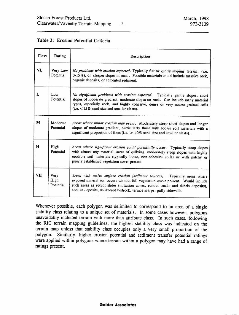
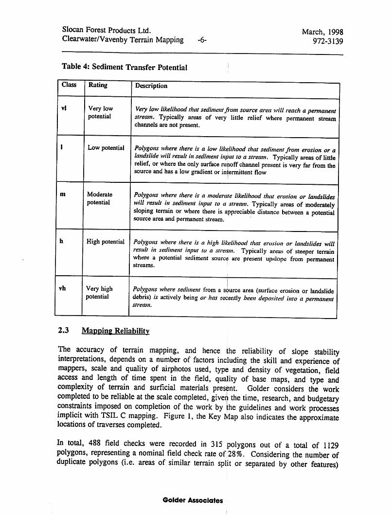
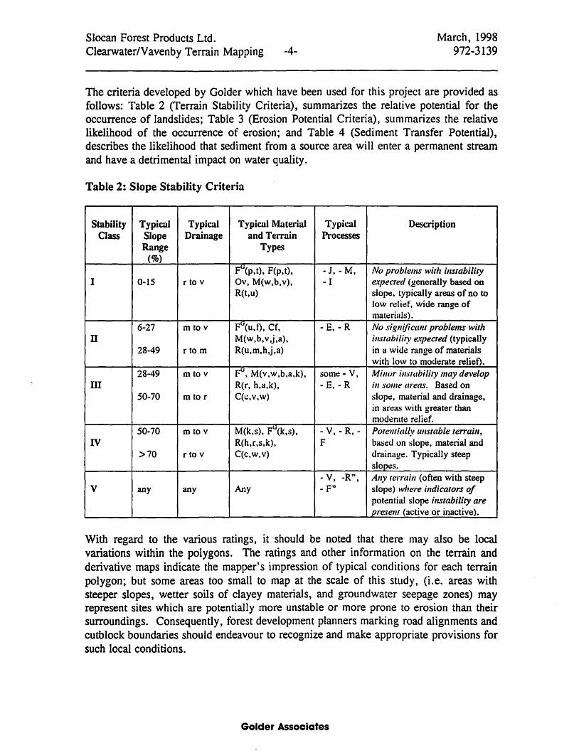
The criteria developed by Golder which have been used for this project are provided as follows: Table 2 (Terrain Stability Criteria), summarizes the relative potential for the occurrence of landslides; Table 3 (Erosion Potential Criteria), summarizes the relative likelihood of the occurrence of erosion; and Table 4 (Sediment Transfer Potential), describes the likelihood that sediment from a source area will enter a permanent stream and have a detrimental impact on water quality.
Table 2: Slope Stability Criteria
Stability Typical Typical Typical Material Typical Description Class Slope Drainage and Terrain Processes
Range Types (%)
Fli(p.t). F(p.t), -J, - M. No problems with illstability I 0-15 r to v Ov, M(w,b.v). - I expected (generally based on
R(t,u) slop~, typically areas of no to low r~li~f, wide range of materials) .
6-27 m to v FG(u.t). Cf, - E, - R No sigllijicallt problems with n M(w,b. v ,j,a). illstabiliry expected (typically
28-49 r to m R(u,m.h,j,a) in a wide range of materials with low to moderate reIiet).
28-49 m to v FG, M(v,w,b,a,k), som~ - V, Millur instability may develop m R(r, h.a.k}, - E. - R ill sOllie areas. Based on
50-70 m to r C(c,v,w) slop~, material and drainage, in areas with greater than moderat~ reli~f,
50-70 m to v M(k,s), Fli(k,s). -V,-R,- Potentially ullstable terraill, IV R(h.r,s,k). F based on slope. material and
>70 r to v C(c.w.v) drainage. Typically steep sIop~s.
- V. -R", AllY ten'aill (often with steep V any any Any - F" slop~) where illdicators of
potential slop~ illstability are present (~tctive or inactive),
With regard to the various ratings, it should be noted that there may also be local variations within the polygons. The ratings and other information on the terrain and derivative maps indicate the mapper's impression of typical conditions for each terrain polygon; but some areas too small to map at the scale of this study, (Le. areas with steeper slopes, wetter soils of clayey materials, and groundwater seepage zones) may represent sites which are potentially more unstable or more prone to erosion than their surroundings. Consequently, forest development planners marking road alignments and cutblock boundaries should endeavour to recognize and make appropriate provisions for such local conditions.
Golder Associates