gps gsm based vehicle tracking system seminar
TRANSCRIPT
A
Seminar Report
on
GPS -GSM Based VehicleTracking System
Submitted By:
Patil Harshal Rajendra
BE [Electronics & Telecommunication]
Guided By:
Prof. M. B. Barawkar
Department of Electronics and Telecommunication
R. C. Patel Institute of Technology,
Shirpur-425405
2015-16
Shirpur Education Society’s
R. C. Patel Institute of Technology,Shirpur, Dist-Dhule
CERTIFICATE
This is to certify that Patil Harshal Rajendra from BE [E&TC] has
satisfactorily carried out seminar work on“GPS -GSM Based Ve-
hicle Tracking System ” and submitted the report in the premises
of Department of Electronics & Telecommunication under the guid-
ance of Prof. M. B. Barawkar during year 2015-2016.
Date:
Place: Shirpur
Seminar Guide Coordinator
Head of Department Principal
Acknowledgement
I take this opportunity to express my heartfelt gratitude towards the Depart-
ment of E&TC RCPIT, Shirpur that gave me an opportunity for presentation of my
seminar in their esteemed organization.
It is a privilege for me to have been associated with Prof. M. B. Barawkar,
my guide during seminar work. I have been greatly benefited by her valuable sug-
gestion and ideas. It is with great pleasure that I express my deep sense of gratitude
to her for her valuable guidance, constant encouragement and patience throughout
this work.
I express my gratitude to Prof. Dr. P. J. Deore [HOD E & TC] for his
constant encouragement, co-operation and support and also thankful to all people
who have contributed in their own way in making this seminar success.
I take this opportunity to thank all the classmates for their company during the
course work and for useful discussion I had with them.
Under these responsible and talented personalities I was efficiently able to com-
plete my seminar in time with success.
Patil Harshal Rajendra
Abstract
A vehicle tracking system combines the installation of an electronic device in
a vehicle, or fleet vehicles, with purpose-designed computer software to enable the
owner or a third party to track the vehicle’s location, collecting data in the process.
Modern vehicle tracking systems commonly use Global Positioning System (GPS)
technology for locating the vehicle, but other types of automatic vehicle location
technology can also be used. Vehicle information can be viewed on electronic maps
via the Internet or specialized software. In the main they are easy to steal, and the
average motorist has very little knowledge of what it is all about. To avoid this kind
of steal we are going to implement a system it provides more security to the vehicle.
Existing System: In the previous system security lock and alarm is implemented in
a car. If a burglar can break open the lock, then it becomes easy for the burglar
to steal the car. And in old security system if the car is stolen then it is out of
the owner control. User doesnt have any awareness about the current location of
the vehicle.The Proposed System: The RF transmitter is attached with the vehi-
cle which has its own identification. This data will be continuously transmitted to
the RF receiver connected to the microcontroller. This GPS will be location the
position of vehicle and transmit that data to the microcontroller. Suppose the RF
receiver not receiving signal from the transmitting unit, receiver unit send the signal
to the microcontroller, from that we can identify the theft. If the vehicle is theft
it automatically sends location of the vehicle to its owner as a SMS through GSM
modem. This will be a much simpler and low cost technique compared to others. If
a password like SMS is sent by the owner, it automatically stops the vehicle.
Contents
List of Figures iii
1 Introduction 1
2 History of Vehicle Tracking 32.1 Early Technology . . . . . . . . . . . . . . . . . . . . . . . . . . . . . 4
3 Hardware Design 63.1 GSM Specifications: . . . . . . . . . . . . . . . . . . . . . . . . . . . . 6
3.1.1 Frequency . . . . . . . . . . . . . . . . . . . . . . . . . . . . . 63.1.2 Modulation . . . . . . . . . . . . . . . . . . . . . . . . . . . . 63.1.3 Access Methods . . . . . . . . . . . . . . . . . . . . . . . . . . 73.1.4 Transmission Rate . . . . . . . . . . . . . . . . . . . . . . . . 73.1.5 Frequency Band . . . . . . . . . . . . . . . . . . . . . . . . . . 73.1.6 Channel Spacing . . . . . . . . . . . . . . . . . . . . . . . . . 73.1.7 Speech Coding . . . . . . . . . . . . . . . . . . . . . . . . . . 73.1.8 Duplex Distance . . . . . . . . . . . . . . . . . . . . . . . . . 8
3.2 GSM Modem . . . . . . . . . . . . . . . . . . . . . . . . . . . . . . . 83.3 GPS Receiver . . . . . . . . . . . . . . . . . . . . . . . . . . . . . . . 93.4 Receiver Features: . . . . . . . . . . . . . . . . . . . . . . . . . . . . . 103.5 Working of GPS . . . . . . . . . . . . . . . . . . . . . . . . . . . . . 10
4 Methodology 124.1 Working . . . . . . . . . . . . . . . . . . . . . . . . . . . . . . . . . . 124.2 Block Diagram and it’s Discription . . . . . . . . . . . . . . . . . . . 134.3 Concept and Overview . . . . . . . . . . . . . . . . . . . . . . . . . . 14
5 Applications 15
6 Advantages and Disadvantages 176.1 Advantages . . . . . . . . . . . . . . . . . . . . . . . . . . . . . . . . 176.2 Disadvantages . . . . . . . . . . . . . . . . . . . . . . . . . . . . . . . 18
i
7 Conclusion and Future Scope 207.1 Conclusion . . . . . . . . . . . . . . . . . . . . . . . . . . . . . . . . . 207.2 Future Scope . . . . . . . . . . . . . . . . . . . . . . . . . . . . . . . 20
References 22
ii
List of Figures
1.1 GPS tracking of vehicle . . . . . . . . . . . . . . . . . . . . . . . . . . 1
3.1 General block diagram of GSM modem . . . . . . . . . . . . . . . . . 93.2 GSM modem . . . . . . . . . . . . . . . . . . . . . . . . . . . . . . . 93.3 GPS reciever . . . . . . . . . . . . . . . . . . . . . . . . . . . . . . . 10
4.1 Block diagram of vehicle tracking system using GPS and GSM . . . . 13
iii
Chapter 1
Introduction
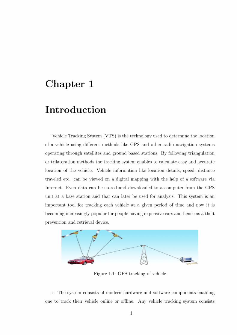
Vehicle Tracking System (VTS) is the technology used to determine the location
of a vehicle using different methods like GPS and other radio navigation systems
operating through satellites and ground based stations. By following triangulation
or trilateration methods the tracking system enables to calculate easy and accurate
location of the vehicle. Vehicle information like location details, speed, distance
traveled etc. can be viewed on a digital mapping with the help of a software via
Internet. Even data can be stored and downloaded to a computer from the GPS
unit at a base station and that can later be used for analysis. This system is an
important tool for tracking each vehicle at a given period of time and now it is
becoming increasingly popular for people having expensive cars and hence as a theft
prevention and retrieval device.
Figure 1.1: GPS tracking of vehicle
i. The system consists of modern hardware and software components enabling
one to track their vehicle online or offline. Any vehicle tracking system consists
1
RCPIT, Shirpur Department of Electronics & Telecommunication
of mainly three parts mobile vehicle unit, fixed based station and, database and
software system.
ii. Vehicle Unit: It is the hardware component attached to the vehicle having
either a GPS/GSM modem. The unit is configured around a primary modem that
functions with the tracking software by receiving signals from GPS satellites or radio
station points with the help of antenna. The controller modem converts the data
and sends the vehicle location data to the server.
iii. Fixed Based Station: Consists of a wireless network to receive and forward
the data to the data center. Base stations are equipped with tracking software and
geographic map useful for determining the vehicle location. Maps of every city and
landmarks are available in the based station that has an in-built Web Server.
iv. Database and Software: The position information or the coordinates of each
visiting points are stored in a database, which later can be viewed in a display screen
using digital maps. However, the users have to connect themselves to the web server
with the respective vehicle ID stored in the database and only then s/he can view
the location of vehicle traveled.
GPS -GSM based Asset tracking system 2
Chapter 2
History of Vehicle Tracking
GPS or Global Positioning Systems were designed by the United States Gov-
ernment and military, which the design was intended to be used as surveillance.
After several years went by the government signed a treaty to allow civilians to buy
GPS units also only the civilians would get precise downgraded ratings. Years after
the Global Positioning Systems were developed the military controlled the systems
despite that civilians could still purchase them in stores. In addition, despite that
Europe has designed its own systems called the Galileo the US military still has
complete control. GPS units are also called tracking devices that are quite costly
still. As more of these devices develop however the more affordable the GPS can
be purchased. Despite of the innovative technology and designs of the GPS today
the devices has seen some notable changes or reductions in pricing. Companies now
have more access to these devices and many of the companies can find benefits.
These days you can pay-as-you go or lease a GPS system for your company. This
means you do not have to worry about spending upfront money, which once stopped
companies from installing the Global positioning systems at one time. Todays GPS
applications have vastly developed as well. It is possible to use the Global Posi-
tioning Systems to design expense reports, create time sheets, or reduce the costs
of fuel consumption. You can also use the tracking devices to increase efficiency
of employee driving. The GPS unit allows you to create Geo-Fences about a des-
ignated location, which gives you alerts once your driver(s) passes through. This
3
RCPIT, Shirpur Department of Electronics & Telecommunication
means you have added security combined with more powerful customer support for
your workers. Todays GPS units are great tracking devices that help fleet managers
stay in control of their business. The applications in todays GPS units make it
possible to take full control of your company. It is clear that the tracking devices
offer many benefits to companies, since you can build automated expense reports
anytime. GPS units do more than just allow companies to create reports. These
devices also help to put an end to thieves. According to recent reports, crime is at a
high, which means that car theft is increasing. If you have the right GPS unit, you
can put an end to car thefts because you can lock and unlock your car anytime you
choose. GPS are small tracking devices that are installed in your car and it will sup-
ply you with feedback data from tracking software that loads from a satellite. This
gives you more control over your vehicles. The chief reason for companies to install
tracking devices is to monitor their mobile workforce. A preventive measure device
allows companies to monitor their employees activities. Company workers can no
longer take your vehicles to unassigned locations. They will not be able to get away
with unauthorized activities at any time because you can monitor their every action
on a digital screen. The phantom pixel is another thing some webmasters do to get
better rankings. Unfortunately it will backfire on you since the search engines do
not want this to occur. You see, the phantom pixel is when you might have a 1
pixel image or an image so small it cannot be seen by the regular eye. They use the
pixel to stuff it with keywords. The search engine can view it in the code, which is
how they know it is there and can give you better rank for the keywords in theory.
Of course since the search engines dont like this phantom pixel you are instead not
getting anything for the extra keywords except sent to the bottomless pit.
2.1 Early Technology
In the initial period of tracking only two radios were used to exchange the infor-
mation. One radio was attached to the vehicle while another at base station by
which drivers were enabled to talk to their masters. Fleet operator could identify
GPS -GSM based Asset tracking system 4
RCPIT, Shirpur Department of Electronics & Telecommunication
the progress through their routes. The technology was not without its limits. It was
restricted by the distance which became a hurdle in accuracy and better connectiv-
ity between driver and fleet operators. Base station was dependent on the driver
for the information and a huge size fleet could not have been managed depending
on man-power only. The scene of vehicle tracking underwent a change with the ar-
rival of GPS technology. This reduced the dependence on man-power. Most of the
work of tracking became electronic. Computers proved a great help in managing a
large fleet of vehicle. This also made the information authentic. As this technology
was available at affordable cost all whether small or big fleet could take benefit of
this technology Because of the cheap accessibility of the device computer tracking
facilities has come to stay and associated with enhanced management. Today each
vehicle carries tracking unit which is monitored from the base station. Base station
receives the data from the unit. All these facilities require a heavy investment of
capital for the installation of the infrastructure of tracking system for monitoring
and dispatching.
GPS -GSM based Asset tracking system 5
Chapter 3
Hardware Design
3.1 GSM Specifications:
GSM modem is used for transmitting and receiving the data. SIM 300 is a tri-
band GSM/GPRS engine. It works on various frequencies i.e. EGSM 900MHz, DCS
1800MHz and PCS 1900MHz.
3.1.1 Frequency
900 MHz or 1800 MHz (Some countries in the Americas including Canada and the
United States use the 850 MHz and 1900 MHz bands, 400 and 450 MHz frequency
bands are assigned in some countries, notably Scandinavia)
3.1.2 Modulation
Modulation is a form of change process where we change the input information into
a suitable format for the transmission medium. We also changed the information
by demodulating the signal at the receiving end.The GSM uses Gaussian Minimum
Shift Keying (GMSK) modulation method.
6
RCPIT, Shirpur Department of Electronics & Telecommunication
3.1.3 Access Methods
Because radio spectrum is a limited resource shared by all users, a method must be
devised to divide up the bandwidth among as many users as possible.GSM chose a
combination of TDMA/FDMA as its method. The FDMA part involves the division
by frequency of the total 25 MHz bandwidth into 124 carrier frequencies of 200 kHz
bandwidth. One or more carrier frequencies are then assigned to each BS. Each
of these carrier frequencies is then divided in time, using a TDMA scheme, into
eight time slots. One time slot is used for transmission by the mobile and one for
reception. They are separated in time so that the mobile unit does not receive and
transmit at the same time.
3.1.4 Transmission Rate
: The total symbol rate for GSM at 1 bit per symbol in GMSK produces 270.833 K
symbols/second. The gross transmission rate of the time slot is 22.8 Kbps.
3.1.5 Frequency Band
The uplink frequency range specified for GSM is 933 - 960 MHz (basic 900 MHz
band only). The downlink frequency band 890 - 915 MHz (basic 900 MHz band
only).
3.1.6 Channel Spacing
This indicates separation between adjacent carrier frequencies. In GSM, this is 200
kHz
3.1.7 Speech Coding
GSM uses linear predictive coding (LPC). The purpose of LPC is to reduce the bit
rate. The LPC provides parameters for a filter that mimics the vocal tract. The
GPS -GSM based Asset tracking system 7
RCPIT, Shirpur Department of Electronics & Telecommunication
signal passes through this filter, leaving behind a residual signal. Speech is encoded
at 13 kbps.
3.1.8 Duplex Distance
The duplex distance is 80 MHz Duplex distance is the distance between the uplink
and downlink frequencies. A channel has two frequencies, 80 MHz apart
3.2 GSM Modem
System contains high Performance ARM controller, a GPS,and GSM modem and
overall system reside into a vehicle. Atracking system will provide effective real
time vehiclelocation reporting .Tracking system will inform where yourvehicle is
and where it has been, how longer it has been there.The basic function of in vehi-
cle unite is to acquire, Monitorand transmit the position latitude, longitude, time
tomanagement center either at fixed interval or on demand.Microcontroller unit
form the heart of tracking unit, whichacquires and process the position data from
the GPS module.The GPS receiver of vehicle terminal receives and resolves thenav-
igation message broadcasted by GPS position satellites,computes the longitude and
latitude of vehicle coordinates, transforms it into the GSM message form by GSM-
communication controller, and sends the message tomonitoring center via the GSM
network The core of data communication about this system lies inwireless commu-
nication control terminals that uses GSM Modules to transfer long-distance data
extensively and reliably. It Support instructions of AT commands. SIM300 can
be integrated with a wide range of applications. SIM300 isa Tri-band GSM/GPRS
engine that works on frequencies EGSM 900 MHz, DCS 1800 MHz and PCS1900
MHzSIM300 provides GPRS multi-slot class 10 capabilities andsupport the GPRS
coding schemes CS-1, CS-2, CS-3 and CS- 4. With a tiny configuration of 40mm x
33mm x 2.85 mm,SIM300 can fit almost all the space requirement in ourapplication.
Therefore, the MCU can connect with GSM modules very expediently through serial
interfaces.
GPS -GSM based Asset tracking system 8
RCPIT, Shirpur Department of Electronics & Telecommunication
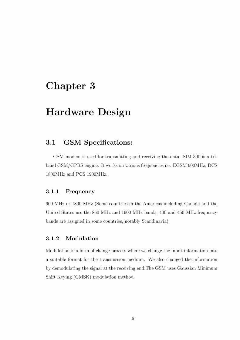
Figure 3.1: General block diagram of GSM modem
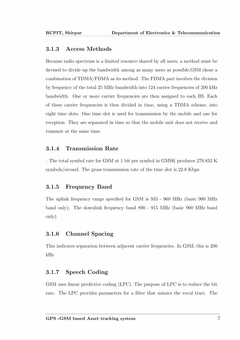
Figure 3.2: GSM modem
3.3 GPS Receiver
The hardware interfaces for GPS units are designed to meet NMEA requirements.
The GPS receiver provides data in NMEA 0183format with a 1Hz update rate.
GPS -GSM based Asset tracking system 9
RCPIT, Shirpur Department of Electronics & Telecommunication
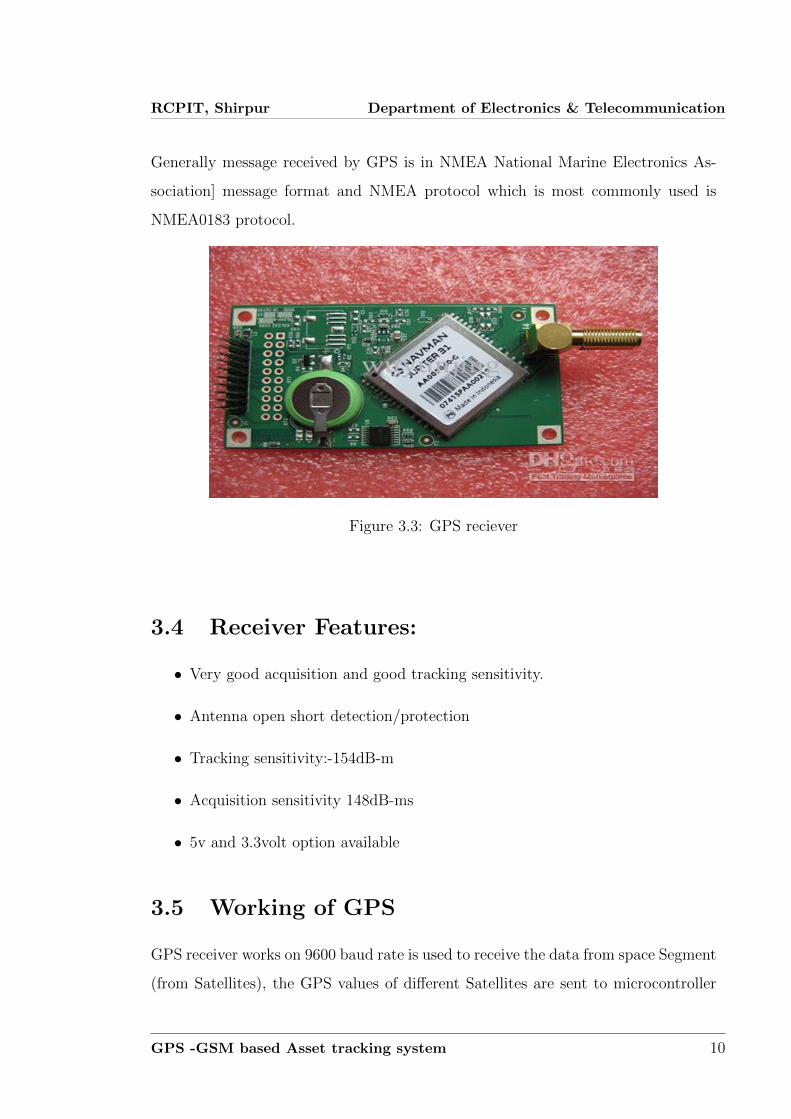
Generally message received by GPS is in NMEA National Marine Electronics As-
sociation] message format and NMEA protocol which is most commonly used is
NMEA0183 protocol.
Figure 3.3: GPS reciever
3.4 Receiver Features:
• Very good acquisition and good tracking sensitivity.
• Antenna open short detection/protection
• Tracking sensitivity:-154dB-m
• Acquisition sensitivity 148dB-ms
• 5v and 3.3volt option available
3.5 Working of GPS
GPS receiver works on 9600 baud rate is used to receive the data from space Segment
(from Satellites), the GPS values of different Satellites are sent to microcontroller
GPS -GSM based Asset tracking system 10
RCPIT, Shirpur Department of Electronics & Telecommunication
AT89S52, where these are processed and forwarded to GSM. At the time of process-
ing GPS receives only GPRMC values only. From these values microcontroller takes
only latitude and longitude values excluding time, altitude, name of the satellite,
authentication etc. E.g. LAT: 1728:2470 LOG: 7843.3089 GSM modem with a baud
rate 57600 . A GPS receiver operated by a user on Earth measures the time it
takes radio signals to travel from four or more satellites to its location, calculates
the distance to each satellite, and from this calculation determines the users longi-
tude, latitude, and altitude. The U.S. Department of Defense originally developed
the Navstar constellation for military use, but a less precise form of the service is
available free of charge to civilian users around the globe. The basic civilian service
will locate a receiver within 10 meters (33 feet) of its true location, though various
augmentation techniques can be used to pinpoint the location within less than 1 cm
(0.4 inch). With such accuracy and the ubiquity of the service, GPS has evolved far
beyond its original military purpose and has created a revolution in personal and
commercial navigation. Battlefield missiles and artillery projectiles use GPS signals
to determine their positions and velocities, but so do the U.S. space shuttle and the
International Space Station as well as commercial jetliners and private airplanes.
Ambulance fleets, family automobiles, and railroad locomotives benefit from GPS
positioning, which also serves farm tractors, ocean liners, hikers, and even golfers.
Many GPS receivers are no larger than a pocket calculator and are powered by
disposable batteries, while GPS computer chips the size of a babys fingernail have
been installed in wristwatches, cellular telephones, and personal digital assistants.
GPS -GSM based Asset tracking system 11
Chapter 4
Methodology
4.1 Working
The project consists of GPS receiver and GSM modem with a micro controller.
The whole system is attached to the vehicle. In the other end (main vehicle station)
one GSM mobile phone is attached to the computer with VB application. So the
GPS system will send the longitudinal and altitude values corresponding to the
position of vehicle to GSM Modem. Imagine the bus has left Bangalore at 6 o
clock in the morning. If the officer in charge for that vehicle wants to know where
the vehicle is, he will come to the computer and click on the vehicle number on
the VB program .The VB program will send an SMS to the vehicle number. The
SMS sent would come through the GSM service provider and then reach the vehicle,
which is traveling, because the vehicle has a GSM device with sim card. This GSM
modem will receive the SMS and send to the microcontroller in the vehicle. The
microcontroller will receive this SMS and compare the password and the command.
If every thing matches then it will perform the request required by the office.
12
RCPIT, Shirpur Department of Electronics & Telecommunication
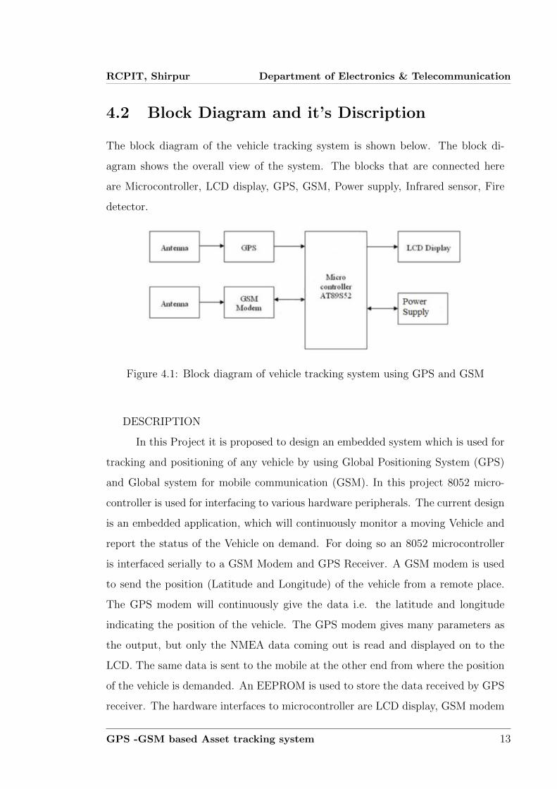
4.2 Block Diagram and it’s Discription
The block diagram of the vehicle tracking system is shown below. The block di-
agram shows the overall view of the system. The blocks that are connected here
are Microcontroller, LCD display, GPS, GSM, Power supply, Infrared sensor, Fire
detector.
Figure 4.1: Block diagram of vehicle tracking system using GPS and GSM
DESCRIPTION
In this Project it is proposed to design an embedded system which is used for
tracking and positioning of any vehicle by using Global Positioning System (GPS)
and Global system for mobile communication (GSM). In this project 8052 micro-
controller is used for interfacing to various hardware peripherals. The current design
is an embedded application, which will continuously monitor a moving Vehicle and
report the status of the Vehicle on demand. For doing so an 8052 microcontroller
is interfaced serially to a GSM Modem and GPS Receiver. A GSM modem is used
to send the position (Latitude and Longitude) of the vehicle from a remote place.
The GPS modem will continuously give the data i.e. the latitude and longitude
indicating the position of the vehicle. The GPS modem gives many parameters as
the output, but only the NMEA data coming out is read and displayed on to the
LCD. The same data is sent to the mobile at the other end from where the position
of the vehicle is demanded. An EEPROM is used to store the data received by GPS
receiver. The hardware interfaces to microcontroller are LCD display, GSM modem
GPS -GSM based Asset tracking system 13
RCPIT, Shirpur Department of Electronics & Telecommunication
and GPS Receiver. In order to interface GSM modem and GPS Receiver to the
controller, a MUX is used. The design uses RS-232 protocol for serial communica-
tion between the modems and the microcontroller. A serial driver IC is used for
converting TTL voltage levels to RS-232 voltage levels. Different types or sensors
such as infrared sensors and fire detector are used for detecting different types of
problem encountered in the vehicle such as theft, accident, fire warning etc. In any
of these cases messages will be automatically send to the intended receiver. When
a request by user is sent to the number at the modem, the system automatically
sends a return reply to that particular mobile indicating the position of the vehicle
in terms of latitude and longitude. A Program has been developed which is used to
locate the exact position of the vehicle and also to navigated track of the moving
vehicle on Google Map.
4.3 Concept and Overview
This vehicle tracking system takes input from GPS and send it through the GSM
module to desired mobile/laptop using mobile communication. Vehicle Tracking
System is one of the biggest technological advancements to track the activities of
the vehicle. The security system uses Global Positioning System GPS, to find the
location of the monitored or tracked vehicle and then uses satellite or radio systems
to send to send the coordinates and the location data to the monitoring center. At
monitoring center various softwares are used to plot the Vehicle on a map. In this
way the Vehicle owners are able to track their vehicle on a real-time basis. Due
to real-time tracking facility, vehicle tracking systems are becoming increasingly
popular among owners of expensive vehicles.
GPS -GSM based Asset tracking system 14
Chapter 5
Applications
When some technology comes to be used at practical level it happens to cherish
both plus as well as minus points of its own. But sometimes technology may be
positive in itself but its application can be misused. Before we go ahead to give
space to any technology in our house or work place we should have pre-estimates of
its fall outs.
• In view of long journeys and night journeys by car the technology can provide
a safety network to the person in condition of emergency. It can cut time of
journey short by providing the information regarding location, speed, distance
from the destination leading to best route planning
• In view of long journeys and night journeys by car the technology can provide
a safety network to the person in condition of emergency. It can cut time of
journey short by providing the information regarding location, speed, distance
from the destination leading to best route planning.
• Best feature of the technology is that it is easy to use. just an automated
unit is needed to be installed in the vehicle and connected to the centre which
may be provided by some company. This instrument is monitored by the GPS
tracking company which keeps all the records or its customers locations. All
details of location etc are communicated to the user by cell phone or internet
connection. Increasing productivity of your mobile workers.
15
RCPIT, Shirpur Department of Electronics & Telecommunication
• It helps monitoring employee driving habits and activities.
• Helps you locate your employees are on-the-road.
• Helps you verify the employee time sheet.
• Helps you in monitoring all your vehicles.
• Helps you in timely delivery of the consignments
• Helps you monitor the vehicle speeds
• Helps you in tracking the movement of vehicles on the road
GPS -GSM based Asset tracking system 16
Chapter 6
Advantages and Disadvantages
6.1 Advantages
• Commercial fleet operators are by far the largest users of vehicle tracking
systems. These systems are used for operational functions such as routing,
security, dispatch and collecting on-board information.
• These systems are also used in consumer vehicles as devices for preventing
theft and retrieving stolen/lost vehicles. The signal sent out by the installed
device help the police to track the vehicle. These tracking systems can be
used as an alternative for traditional car alarms or in combination with it.
Installing tracking systems can thus bring down the insurance costs for your
vehicle by reducing the risk factor.
• Vehicle Tracking systems often have several alternatives, like sending auto-
matic alerts to a phone or email if the vehicle is moved without due authoriza-
tion. They can also work as one layer of several combined security measures
• Apart from security concerns, the tracking systems can also help users such
as taxi services to improve their customer service. The systems enable the
operators to identify the empty taxis and direct the nearest one to pick up the
customer
17
RCPIT, Shirpur Department of Electronics & Telecommunication
• Vehicle tracking systems can also be applied for monitoring driving behavior
for both commercial and individual situations. Parents for instance can use
tracking devices to keep an eye on their teenage sons driving. The applications
for this project are in military, navigation, automobiles, aircrafts, fleet man-
agement, remote monitoring, remote control, security systems, teleservices,
etc.
• Fleet monitoring
• Vehicle scheduling
• Route monitoring
• Driver monitoring
• Accident analysis
• Geo-fencing geo-coding
6.2 Disadvantages
• This program is highly sensitive to the camera position and the environment,
so a considerable amount of tuning has to be done each time a new video is
taken or camera position is changed and even more so if the video is of an
entirely new environment.
• If there is noise in the edge detected image, we can’t really track the vehicle.
What is meant by noise is that if some humans are coming near to the car
then the edge detected image will have the edges of that human or animal or
tree, then the program will try to match those edges with the car model. The
program might treat this match as a success but really it will be off the track.
• We could not model the curves in the maruti-800, like in some images the
driver and the steering can be seen, but we could not find a solution for that.
GPS -GSM based Asset tracking system 18
RCPIT, Shirpur Department of Electronics & Telecommunication
Also the body of the Maruti can be best modeled as combination of curves
and the lines.
• Also if distance between the vehicle positions in the two consecutive frames
is too much then this tracking program can’t detect the vehicle in the second
frame and will try to track it in the subsequent frame
• The main limitation of the software is the real time implementation, this cant
be implemented with this much time efficiency in any of the real time appli-
cations. This limitation is mainly due to the processing time.
GPS -GSM based Asset tracking system 19
Chapter 7
Conclusion and Future Scope
7.1 Conclusion
Tracking system is becoming increasingly important in largecities and it is more
secured than other systems. It iscompletely integrated so that once it is implemented
in all vehicles, then it is possible to track anytime from anywhere. Ithas real-time
capability, emerges in order to strengthen therelations among people, vehicle and
road by putting modern information technologies together and able to forms a real-
timeaccurate, effective comprehensive transportation system.This system has many
advantages such as large capability, wide areas range, low operation costs, effective,
Strong expandability and Easy to use in vehicle traffic administration.Upgrading
this setup is very easy which makes it open to future a requirement which also
makes it more efficient.
7.2 Future Scope
• We can use the EEPROM to store the previous Navigating positions up to
256 locations and we can navigate up to N number of locations by increasing
its memory.
20
RCPIT, Shirpur Department of Electronics & Telecommunication
• We can reduce the size of the kit by using GPS+GSM on the same module.
• We can increase the accuracy up to 3m by increasing the cost of the GPS
receivers.
• We can use our kit for detection of bomb by connecting to the bomb detector.
• With the help of high sensitivity vibration sensors we can detect the accident.
• Whenever vehicle unexpectedly had an accident on the road with help of vi-
bration sensor we can detect the accident and we can send the location to the
owner, hospital and police.
• We can use our kit to assist the traffic. By keeping the kits in the entire
vehicles and by knowing the locations of all the vehicles.
• If anybody steals our car we can easily find our car around the globe. By
keeping vehicle positioning vehicle on the vehicle.
GPS -GSM based Asset tracking system 21
References
[1] R.Ramani, S.Selvaraju, S.Valarmathy, R.Thangam B.Rajasekaran, water-level
monitor for bore well and water tank based on GSM, International Journal of
engineering science and technology (IJEST), ISSN: 0975-5462, volume 4-N0:10,
october2012
[2] Asaad M. J. Al-Hindawi, Ibraheem Talib, Experimentally Evaluation of
GPS/GSM Based System Design, Journal of Electronic Systems Volume 2
Number 2 June 2012
[3] Abed khan M.E.(Student), , Ravi Mishra, GPSGSM Based Tracking System
SSCET, CSVTU, Bhilai, India International Journal of Engineering Trends and
Technology vol.3,no.,pp,161 -164
[4] Kunal Maurya , Mandeep Singh, Neelu Jain Real Time Vehicle Tracking Sys-
tem using GSM and GPS Technology ”International Journal of Electronics and
Computer Science Engineering”.ISSN 2277 1956 /V1N3-1103-1107
22