grace measurement of total water storage variations over texas · 1-08-2008 grace measurement of...
TRANSCRIPT

1-08-2008
GRACE Measurement of Total Water Storage Variations Over Texas
Byron Tapley , Srinivas Bettadpur Himanshu Save, Tatyana Pekker
University of Texas Center for Space Research
First Texas Water Forum - Drought 2012 Austin, TX February 13, 2012

GRACE Observations and The Global Water Cycle
GRACE measures the change in all forms of the water stored on land after precipitation has been stored as snow, filtrated into the ground, evaporated or departed a basin as stream flow
Global Gravity Measurements
determine Mean Global Mass
Distribution and the Temporal
Variations which measure
change in water mass of land
and oceans

GRACE 1 HAIRS
GRACE 2
GPS Satellites
Ground-Based GPS Receiver
Mass Anomalies
Grace Mission Concept
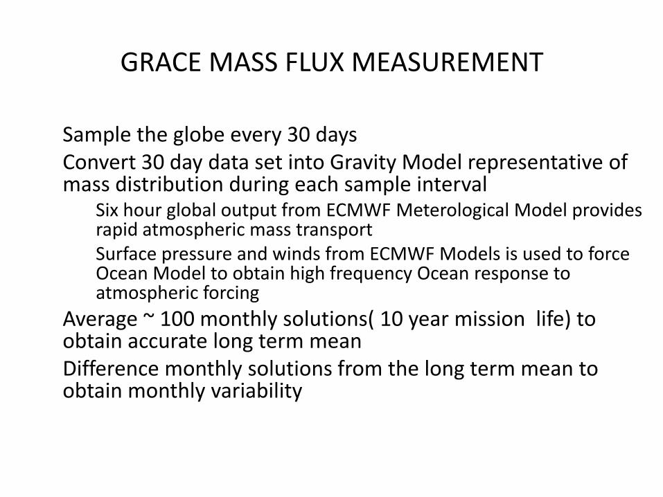
GRACE MASS FLUX MEASUREMENT
Sample the globe every 30 days Convert 30 day data set into Gravity Model representative of mass distribution during each sample interval
Six hour global output from ECMWF Meterological Model provides rapid atmospheric mass transport Surface pressure and winds from ECMWF Models is used to force Ocean Model to obtain high frequency Ocean response to atmospheric forcing
Average ~ 100 monthly solutions( 10 year mission life) to obtain accurate long term mean Difference monthly solutions from the long term mean to obtain monthly variability
1-08-2008
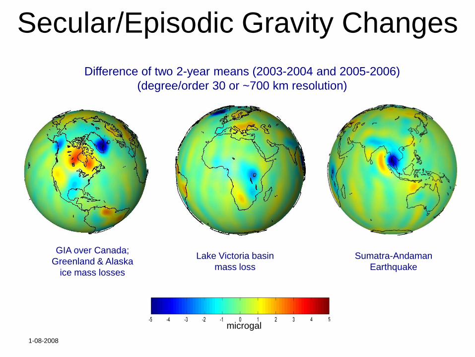
Secular/Episodic Gravity Changes
Difference of two 2-year means (2003-2004 and 2005-2006)
(degree/order 30 or ~700 km resolution)
GIA over Canada;
Greenland & Alaska
ice mass losses
Lake Victoria basin
mass loss
Sumatra-Andaman
Earthquake
microgal

GRACE DETERMINED REGIONAL MASS FLUX
CM of Water

GRACE Global Mass Estimate
Trends (mm/yr)
Ocean = 1.2± 0.3
Land = 0.3 ± 0.5
Greenland = -0.60 ± 0.1 Antarctica = -0.40 ± 0.2
Famiglietti, 2009
GRACE/Jason/Argo Closure
Grace Trend(2003-2009.5) = 1.3+/- 0.8 mm/yr
Chambers,, 2009
400 km smoothing
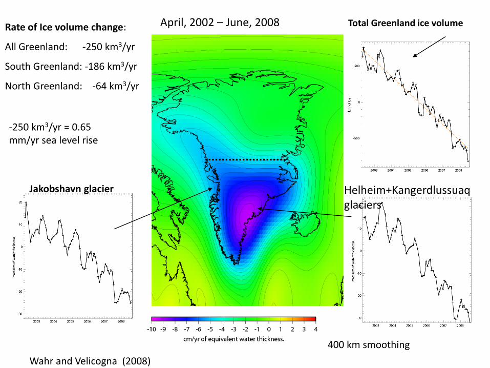
Rate of Ice volume change:
All Greenland: -250 km3/yr
South Greenland: -186 km3/yr
North Greenland: -64 km3/yr
Total Greenland ice volume April, 2002 – June, 2008
-250 km3/yr = 0.65 mm/yr sea level rise
Jakobshavn glacier Helheim+Kangerdlussuaq glaciers
Wahr and Velicogna (2008)

Development of the exceptional 2009 Amazon flood from GRACE
GRACE observed monthly TWS anomaly (seasonal signal is removed)

Units: cm/yr of water thickness
GRACE TWS
Rate Map

Groundwater Monitoring Estimates match groundwater well measurements
Method is applied in regions where groundwater is not well monitored, but
depletion is likely: Africa, Middle East, etc.
Illinois
Illinois
280,000 sq km
Swenson, 2007

GRACE DETECTS GROUNDWATER LOSS IN INDIA
Pattern of groundwater depletion in NW India
Loss of 109 km3
(3 Lake Meads)
over 72 months
Rodell et al., 2009

Applications to State requirements
• Observation from previous slides: – Grace observations are global, homogeneous, very
accurate and nearly synoptic
– Successful application in global studies has demonstrated a paradigm shifting capability for science applications.
– Data is released at monthly intervals four to six weeks after month end
• Support of Texas State operational activities requires: – Determining appropriate products and
– Developing a system for rapid delivery of products • A Rapid Product with a daily delivery has under study

Texas Drought 2005-2006
Texas Drought 2011
GRACE Observed Total Water Variation
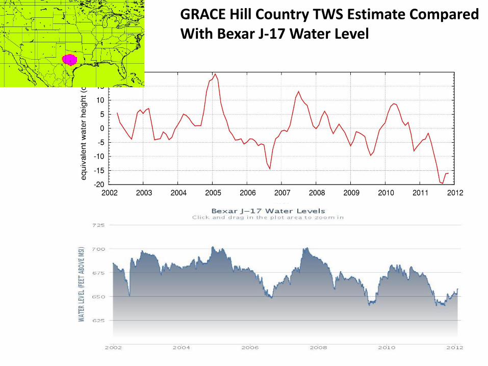
GRACE Hill Country TWS Estimate Compared With Bexar J-17 Water Level

Texas Gulf Coast Hydrologic Region
Area= 404,993 km^2

Proposed Effort
• Conduct Study to Develop Best Approach for Realizing the GRACE Observed Texas TWS Variations.
• Realization of a GRACE Rapid Product to support water resource and drought response decisions
• Assimilation of GRACE Results into Hydrological Models to improve spatial and temporal resolution
• Use of GRACE data along with other satellite, insitu and model data to develop a forcast capability for water management and drought mitigation activities.

For more on GRACE, visit: http://www.csr.utexas.edu/grace
END