grafex ancuabe graphite mine project, ancuabe, mozambique ancuabe 206amber2… · ·...
TRANSCRIPT
GRAFEX ANCUABE GRAPHITE MINE PROJECT,
ANCUABE, MOZAMBIQUE
DRAFT
VOLUME 1A: DRAFT ENVIRONMENTAL PRE-FEASIBILITY SCOPING STUDY
AND TERMS OF REFERENCE
April 2017
Prepared for:
GRAFEX, LIMITADA.
25 Setembro Avenue nº. 1383, 6º floor, Flat 613, Maputo Moçambique
www.tritonminerals.com
Prepared by:
COASTAL & ENVIRONMENTAL SERVICES MOZAMBIQUE LDA
Avenida da Mozal, Porta 2334 Beluluane Celula D. Quarteirao 02, Matola Cidade, Maputo, Mozambique
With offices in Cape Town, East London, Johannesburg,
Grahamstown and Port Elizabeth (South Africa)
www.cesnet.co.za

Draft Environmental Pre-feasibility Scoping Study and Terms of Reference – April 2017
Coastal & Environmental Services ii Grafex Lda. Ancuabe
GRAFEX ANCUABE GRAPHITE PROJECT,
ANCUABE, MOZAMBIQUE
DRAFT
VOLUME 1A: DRAFT ENVIRONMENTAL PRE-FEASIBILITY SCOPING STUDY
AND TERMS OF REFERENCE
April 2017
Prepared for:
GRAFEX, LIMITADA.
25 Setembro Avenue nº. 1383, 6º floor, Flat 613, Maputo Moçambique
www.tritonminerals.com
Prepared by:
COASTAL & ENVIRONMENTAL SERVICES MOZAMBIQUE LDA
Avenida da Mozal, Porta 2334 Beluluane Celula D. Quarteirao 02, Matola Cidade, Maputo, Mozambique
With offices in Cape Town, East London, Johannesburg,
Grahamstown and Port Elizabeth (South Africa)
www.cesnet.co.za

Draft Environmental Pre-feasibility Scoping Study and Terms of Reference – April 2017
Coastal & Environmental Services iii Grafex Lda. Ancuabe
NON-TECHNICAL SUMMARY INTRODUCTION Grafex Limitada (Grafex), a Mozambican subsidiary company of Triton Minerals Limited, intend to develop a graphite mine in the district of Ancuabe in Cabo Delgado Province, northern Mozambique. The Project Area that will be assessed as part of this Environmental and Social Impact Assessment (ESIA) is referred to as the Ancuabe Graphite Project and is located approximately 80km west of Pemba. The license area (Exploration License 5380, 5305 and 5336) covers approximately 151,094ha however the project area DUAT applications for this project will cover a much smaller area of approximately 11,368ha within which there are four deposits referred T12, T14, T15 and T16. The exact dimensions of the four deposits is still to be determined and will depend on the outcome of economic analysis for each of the deposits currently be studied. Grafex have appointed EOH Coastal and Environmental Services (CES) to undertake an ESIA in accordance with the Mozambican ESIA process regulated by Decree No. 54/2015. CES is a company registered in Mozambique, with the Ministério de Terra, Ambiente e Desenvolvimento Rural (MITADER) and has solid knowledge and multidisciplinary teams to conduct environmental impact assessments and environmental management programs. The project being considered here is a category A (Annexure II) project and is subject to a full ESIA as defined by the regulations, due to the nature, scale and location of the proposed project. In accordance with industry practice, this scoping report is being undertaken at the start of the decision making process. This will ensure that alternative economic mining scenarios can be considered during the scoping phase, so that the most environmentally and socially acceptable project can be developed whilst maintaining practical and realistic mine development. ANCUABE GRAPHITE PROJECT The company commenced with a technical scoping study and completed in April 2017. In addition, feasibility studies that include metallurgical test work were commissioned in April 2017 and are expected to be completed by November 2017. Initial results indicate high purity graphite concentrate. Ancuabe graphite is known for its large flake size and properties to produce a high purity concentrate. High purity flake graphite commends a significant premium in the Lithium Ion Battery (LIB) market and large flake size graphite commands even higher prices for supply into the expandable graphite market. It is anticipated that the development of the graphite mine will benefit local communities living in the immediate vicinity of the mine through the creation of direct and indirect jobs. The proposed development will also increase the mining royalties paid to the Mozambican government and will result in the implementation of various Corporate Social Responsibility projects to uplift the project affected communities, the details of which will be determined in consultation with the communities. GENERALISED DESCRIPTION OF THE MINING PROCESS Prior to mining, vegetation will be cleared by mechanical means and the topsoil removed and carefully stored to assist with subsequent rehabilitation. The graphite will be extracted using conventional open pit mining methods which will include drill and blast, load and haul techniques to extract the ore. Initially the softer oxidised material near the surface (typically the top 5-10m of the deposit) will be ripped with a bulldozer and once hard rock is encountered, drill and blast techniques will be used. The extracted ore will be processed on site through a number of steps that includes crushing the ore, followed by milling, which is a process used to recycle the oversize ore back to the primary mill and the undersize ore to the flotation circuit. This step is to ensure the ore meets the optimum particle size for beneficiation of graphite. Product from the milling circuit then passes through a series of flotation stages before the concentrate is thickened to produce a graphite concentrate in solution. The concentrate is then filtered, dried and screened to produce a number of different
Draft Environmental Pre-feasibility Scoping Study and Terms of Reference – April 2017
Coastal & Environmental Services iv Grafex Lda. Ancuabe
graphite size products at the mine site. Each dry graphite product will be stored in dedicated storage bins before being packaged into 1 tonne bulka-bags ready for dispatch by road to port for shipment. The tailings produced by the process are fed to the tailings thickener where flocculent is added to accelerate the settling and separation of solids from water. The thickened tailings are then pumped to the Tailings Storage Facility (TSF) for disposal. Thickener overflow water gravitates to the process water pond and is recycled within the processing plant. Tailings dam return water will also be recovered via a decant system to be pumped directly to the process water dam for reuse in the process plant. Unprocessed storm water, plant run-off and a portion of the water used for general washing applications will be collected in a containment dam from where it will be pumped to the process water dam for recycling. It is anticipated that the total amount of ore to be treated by the process plant each year averages 1 million tonnes per annum over the life of the mine. The lifetime of the mine is anticipated to be more than 25 years. INFRASTRUCTURE The following infrastructure will be required as part of the development and each will be assessed during the ESHIA and project economic studies:
Site roads providing access from existing gravel access roads to the proposed mining camp, plant, office buildings, maintenance yards, water storage, tailings storage and other infrastructure;
A lay-down area for construction materials and equipment of approximately 250 m x 250 m in total, across several locations. This area will continue to be used during the operational phase, although the actual area of land required may be reduced to an area of approximately 100 m x 100 m;
Accommodation camp during the construction period for approximately 200 persons;
Mining Camp to accommodate approximately 100 persons in single person housing facilities for the operational phase;
Small clinic for staff and contractors;
Site offices located adjacent to the plant. The exact dimensions and location will be determined as the project advances and more details are known;
Site services including bunded fuel storage areas and fuelling station, potable water treatment facility, sewage treatment facility, mine explosive storage facility and plant laboratory;
A perimeter fence around the power station including power switchyard and transformers and camp will be established; and
A process plant that includes a plant workshop and store, reagent and consumable storage, control room, crib and change rooms, plant offices, power station, switchyard and transformers and mobile plant.
A Landfill site will be required as mining operations will generate general solid wastes (food, glass, paper, wood, metal, oils and lubricants) which will need to be disposed appropriately in designated waste sites. The site for the landfill will be determined based on environmental suitability to prevent leachates etc.
In addition, the Ancuabe Graphite project will include:
Tailings storage facility.
Waste rock dumps comprising up to 83 Mt in the first 30 years of operation.
Raw water dam with approximately a 2 Mm3 capacity. The position and exact size of this infrastructure is not currently defined and will need to take into account environmental sensitivities and economic engineering requirements which will become clearer as the EIA process proceeds.

Draft Environmental Pre-feasibility Scoping Study and Terms of Reference – April 2017
Coastal & Environmental Services v Grafex Lda. Ancuabe
EXISTING BIOPHYSICAL ENVIRONMENT The majority of the Ancuabe graphite resource is located within undisturbed uniform forest and Miombo Woodland with tall trees and complex structure. Initial surveys suggest this area would be classified as Natural Habitat according to the IFC standards. Faunal species diversity is also expected to be relatively high for this site given that the available habitat is largely intact although it is expected that this diversity will be limited to herpetofauna, birds and small mammals. Faunal diversity is greater in areas of natural habitat and according to interviews with local communities large mammals do occur in the area, including lion, leopard, elephant, impala, samango monkeys and baboons these are likely to be absent due to hunting pressures in the area however they are likely to occur in the Quirimbas National Park which occurs immediately north of the project site (~12km) and ~ 3 km from the 10km buffer placed around the reserve. EXISTING SOCIAL ENVIRONMENT The project area is characterised by limited human activity. The only machambas that occur within the project area are along the most south western point of the haul road (where the haul road joins the main road) and approximately five machambas and associated machambas within the proposed dam (WSF) site. There are currently no communities residing in the remainder of the project area. It is anticipated that both economic resettlement (the loss of economic activity and livelihoods, such as loss of crop fields) and physical resettlement will take place. Overall, the use of the project area for agriculture appears to be very limited, and the area is mainly used for natural resource use (fuel wood, plant harvesting and hunting). There also appeared to be limited signs of harvesting for charcoal production. RISK ASSESSMENT AND WAY FORWARD As part of this report, an environmental risk assessment was conducted to identify salient impacts and issues that will need to be addressed in the forthcoming ESIA. Environmental and social impacts were assessed at the broader issues level, and a risk assessment scale was used to identify significant project related risks. An environmental significance scale, which evaluates the importance of a particular impact, is applied to the identified project impacts. The difficulty of mitigating impacts (mitigation potential) was then assessed, and the relationship between impact significance and mitigation potential was used to assess the residual risk after mitigation measures are applied, based on the matrix in chapter 7 of the report. The implications of the four risk categories are as follows: Risk Description
Extreme
Significant mitigatory actions would be required to reduce these risks. In some cases it may not be possible to reduce these extreme risks meaning they are likely to prevent the option from being used (raised as red flags in this assessment).
Major
These risks are of a serious nature, and without effective mitigation measures would be major hindrances to the project. These would need to be monitored and managed, and in combination with Major risks may necessitate the use of a different option to achieve the projects objectives.
Medium
These risks are of a less serious nature but still important, and need to be reduced to As Low As Reasonably Possible (ALARP) for the benefit of the environment or social network affected. In isolation these risks are generally insufficient to prevent the project from proceeding.
Minor
These risks are generally acceptable to the project and environment, and mitigation is desirable but not essential. Best industry practice, however, should be followed and the risks mitigated to prevent a cumulative effect of such impacts.
Draft Environmental Pre-feasibility Scoping Study and Terms of Reference – April 2017
Coastal & Environmental Services vi Grafex Lda. Ancuabe
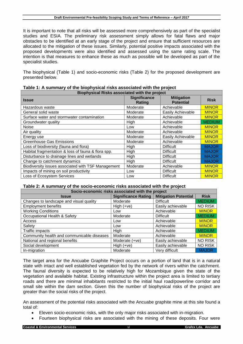
It is important to note that all risks will be assessed more comprehensively as part of the specialist studies and ESIA. The preliminary risk assessment simply allows for fatal flaws and major obstacles to be identified at an early stage of the project and ensure that sufficient resources are allocated to the mitigation of these issues. Similarly, potential positive impacts associated with the proposed developments were also identified and assessed using the same rating scale. The intention is that measures to enhance these as much as possible will be developed as part of the specialist studies. The biophysical (Table 1) and socio-economic risks (Table 2) for the proposed development are presented below. Table 1: A summary of the biophysical risks associated with the project
Biophysical Risks associated with the project
Issue Significance
Rating Mitigation Potential
Risk
Hazardous waste Moderate Achievable MINOR
General solid waste Moderate Easily Achievable MINOR
Surface water and stormwater contamination Moderate Achievable MINOR
Groundwater quality High Achievable MEDIUM
Noise Low Achievable MINOR
Air quality Moderate Achievable MINOR
Energy use Moderate Easily Achievable MINOR
Greenhouse Gas Emissions Moderate Achievable MINOR
Loss of biodiversity (fauna and flora) High Difficult MAJOR
Habitat fragmentation & loss of fauna & flora spp. High Difficult MAJOR
Disturbance to drainage lines and wetlands High Difficult MAJOR
Change to catchment dynamics High Difficult MAJOR
Biodiversity issues associated with TSF Management Moderate Achievable MINOR
Impacts of mining on soil productivity Low Difficult MINOR
Loss of Ecosystem Services Low Difficult MINOR
Table 2: A summary of the socio-economic risks associated with the project
Socio-economic risks associated with the project
Issue Significance Rating Mitigation Potential Risk
Changes to landscape and visual quality Moderate Difficult MEDIUM
Employment benefits High (+ve) Easily achievable NO RISK
Working Conditions Low Achievable MINOR
Occupational Health & Safety Moderate Difficult MEDIUM
Access Low Achievable MINOR
Safety Low Achievable MINOR
Traffic impacts High Achievable MEDIUM
Community health and communicable diseases Moderate Achievable MINOR
National and regional benefits Moderate (+ve) Easily achievable NO RISK
Social development High (+ve) Easily achievable NO RISK
In-migration Moderate Very difficult MAJOR
The target area for the Ancuabe Graphite Project occurs on a portion of land that is in a natural state with intact and well established vegetation fed by the network of rivers within the catchment. The faunal diversity is expected to be relatively high for Mozambique given the state of the vegetation and available habitat. Existing infrastructure within the project area is limited to tertiary roads and there are minimal inhabitants restricted to the initial haul road/powerline corridor and small site within the dam section. Given this the number of biophysical risks of the project are greater than the social risks of the project. An assessment of the potential risks associated with the Ancuabe graphite mine at this site found a total of:
Eleven socio-economic risks, with the only major risks associated with in-migration.
Fourteen biophysical risks are associated with the mining of these deposits. Four were
Draft Environmental Pre-feasibility Scoping Study and Terms of Reference – April 2017
Coastal & Environmental Services vii Grafex Lda. Ancuabe
considered to be major risks, five were considered to be medium risks and five were considered to be minor risks
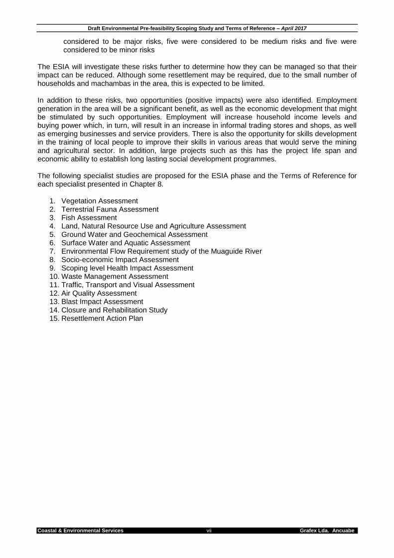
The ESIA will investigate these risks further to determine how they can be managed so that their impact can be reduced. Although some resettlement may be required, due to the small number of households and machambas in the area, this is expected to be limited. In addition to these risks, two opportunities (positive impacts) were also identified. Employment generation in the area will be a significant benefit, as well as the economic development that might be stimulated by such opportunities. Employment will increase household income levels and buying power which, in turn, will result in an increase in informal trading stores and shops, as well as emerging businesses and service providers. There is also the opportunity for skills development in the training of local people to improve their skills in various areas that would serve the mining and agricultural sector. In addition, large projects such as this has the project life span and economic ability to establish long lasting social development programmes. The following specialist studies are proposed for the ESIA phase and the Terms of Reference for each specialist presented in Chapter 8.
1. Vegetation Assessment 2. Terrestrial Fauna Assessment 3. Fish Assessment 4. Land, Natural Resource Use and Agriculture Assessment 5. Ground Water and Geochemical Assessment 6. Surface Water and Aquatic Assessment 7. Environmental Flow Requirement study of the Muaguide River 8. Socio-economic Impact Assessment 9. Scoping level Health Impact Assessment 10. Waste Management Assessment 11. Traffic, Transport and Visual Assessment 12. Air Quality Assessment 13. Blast Impact Assessment 14. Closure and Rehabilitation Study 15. Resettlement Action Plan
Draft Environmental Pre-feasibility Scoping Study and Terms of Reference – April 2017
Coastal & Environmental Services viii Grafex Lda. Ancuabe
This Report should be cited as follows: Coastal & Environmental Services, April 2017, Grafex Limitada. Ancuabe Graphite Project, Draft Pre-feasibility and Environmental Scoping Report, CES, Cape Town.
Copyright This document contains intellectual property and propriety information that are protected by copyright in favour of EOH Coastal & Environmental Services (CES) and the specialist consultants. The document may therefore not be reproduced, used or distributed to any third party without the prior written consent of CES. This document is prepared exclusively for submission to Grafex Limitada, and is subject to all confidentiality, copyright and trade secrets, rules intellectual property law and practices of Mozambique and South Africa.

Draft Environmental Pre-feasibility Scoping Study and Terms of Reference – April 2017
Coastal & Environmental Services ix Grafex Lda. Ancuabe
TABLE OF CONTENTS
1. INTRODUCTION ................................................................................................................... 13
1.1. Introduction .................................................................................................................... 13 1.2. The Proponent ............................................................................................................... 13 1.3. The Consultants ............................................................................................................ 14 1.4. Expertise of the team ..................................................................................................... 14
1.4.1. EOH Coastal & Environmental Services ESHIA Management Team ..................... 14
2. ESHIA PROCESS ................................................................................................................. 16
2.1. The Environmental Impact Assessment Process in Mozambique .................................. 16 2.1.1. Step 1: Pre-Evaluation (Application and Screening) ............................................... 16 2.1.2. Step 2: Environmental Pre-feasibility Scoping Study and Terms of Reference ....... 17 2.1.3. Step 3: Authority Review of the Environmental Pre-feasibility Scoping Study and Terms of Reference .............................................................................................................. 17 2.1.4. Step 4: The Public Participation Process ............................................................... 17 2.1.5. Step 5: Environmental Impact Study and Environmental Management Programme (EMPr) 18 2.1.6. Step 6: Authority Review of the Environmental Impact Report and Environmental Management Programme ...................................................................................................... 18
2.2. Applicable Mozambican legislation ................................................................................ 19 2.3. International standards applied to this project ................................................................ 24
2.3.1. International Finance Corporation Performance Standards .................................... 24 2.3.2. IFC General EHS Guidelines ................................................................................. 27 2.3.3. IFC EHS Guidelines for Mining .............................................................................. 28
2.4. International conventions ............................................................................................... 28
3. PROJECT DESCRIPTION .................................................................................................... 29
3.1. Introduction and Project Background ............................................................................. 29 3.2. Rationale for this development ...................................................................................... 29 3.3. Generalised Description of the proposed mining process .............................................. 30
3.3.1. Vegetation clearing ................................................................................................ 30 3.3.2. Mining Method ....................................................................................................... 31 3.3.3. Infrastructure.......................................................................................................... 35 3.3.4. Water and Power Supplies..................................................................................... 37 3.3.5. Transport ............................................................................................................... 37
3.4. Employment Opportunities ............................................................................................ 37 3.5. Project Alternatives ........................................................................................................ 38
3.5.1. Fundamental Alternatives ...................................................................................... 38 3.5.2. Incremental Alternatives ........................................................................................ 39
4. DESCRIPTION OF THE BIOPHYSICAL ENVIRONMENT .................................................... 40
4.1. Physical Environment .................................................................................................... 40 4.1.1. Climate .................................................................................................................. 40 4.1.2. Topography ........................................................................................................... 41 4.1.3. Hydrology .............................................................................................................. 43 4.1.4. Geology and Soils .................................................................................................. 44 4.1.5. Land use ................................................................................................................ 45
4.2. Biological Environment .................................................................................................. 47 4.2.1. Vegetation ............................................................................................................. 47 4.2.2. Fauna .................................................................................................................... 49 4.2.3. WWF Eco regions .................................................................................................. 49 4.2.4. Protected Areas ..................................................................................................... 50
5. DESCRIPTION OF THE SOCIO-ECONOMIC ENVIRONMENT ............................................ 52
5.1. Introduction .................................................................................................................... 52

Draft Environmental Pre-feasibility Scoping Study and Terms of Reference – April 2017
Coastal & Environmental Services x Grafex Lda. Ancuabe
5.2. DEMOGRAPHICS AND SOCIAL INFRASTRUCTURE ................................................. 52 5.2.1. Cabo Delgado Province ......................................................................................... 52 5.2.2. Ancuabe District ..................................................................................................... 52 5.2.3. Ancuabe Town ....................................................................................................... 53 5.2.4. Villages .................................................................................................................. 53
5.3. EMPLOYMENT SECTORS ........................................................................................... 53 5.4. Agriculture and livelihood strategies .............................................................................. 53 5.5. SOCIOECoNOMIC SETTING ........................................................................................ 54
6. STAKEHOLDER AND COMMUNITY ENGAGEMENT PROCESS ........................................ 55
6.1. Introduction .................................................................................................................... 55 6.2. Mozambique legislation ................................................................................................. 55 6.3. IFC Regulations and requirements for stakeholder engagement ................................... 56 6.4. public participation activities .......................................................................................... 56
6.4.1. EPDA Stakeholder Engagement Process .............................................................. 56
7. PRELIMINARY ENVIRONMENTAL AND SOCIAL RISK ASSESSMENT .............................. 57
7.1. Risk Assessment Methodology ...................................................................................... 57 7.2. Key Biological Impacts and Risks .................................................................................. 58 7.3. Key Social and Planning Impacts and Risks .................................................................. 61
8. TERMS OF REFERENCE FOR SPECIALIST STUDIES ....................................................... 65
8.1. Introduction .................................................................................................................... 65 8.2. Specialist Team ............................................................................................................. 66 8.3. Detailed terms of reference ........................................................................................... 71
8.3.1. Study 1 - Vegetation Assessment .......................................................................... 71 8.3.2. Study 2 - Terrestrial Fauna Assessment ................................................................ 71 8.3.3. Study 3 - Fish Assessment .................................................................................... 71 8.3.4. Study 4: Land, Natural Resource Use and Agriculture Assessment ....................... 72 8.3.5. Study 5: Groundwater and Geochemical Assessment ........................................... 72 8.3.6. Study 6 - Surface Water and Aquatic Assessment ................................................. 73 8.3.7. Study 7: Environmental Flow Requirements Study of the Muaguide River ............. 74 8.3.8. Study 8: Socio-economic Impact Assessment ........................................................ 74 8.3.9. Study 9: Scoping Level Health Impact Assessment (HIA) ...................................... 74 8.3.10. Study 10: Waste Management Assessment ........................................................... 75 8.3.11. Study 11: Traffic, Transport and Visual Assessment .............................................. 76 8.3.12. Study 12: Air Quality Assessment .......................................................................... 76 8.3.13. Study 13 - Blast Impact Assessment ...................................................................... 77 8.3.14. Study 14 - Conceptual Closure and Rehabilitation Plan ......................................... 77 8.3.15. Study 15 – Resettlement Action Plan ..................................................................... 78
9. CONCLUSIONS AND WAY FORWARD ............................................................................... 79
9.1. Conclusions ................................................................................................................... 79 9.1.1. Biophysical conclusions ......................................................................................... 79 9.1.2. Socio-economic conclusions .................................................................................. 79 9.1.3. Summary conclusions ............................................................................................ 80
9.2. Way forward .................................................................................................................. 82 9.2.1. Volume 1: EPDA/Scoping Report (This Volume) .................................................... 82 9.2.2. Volume 2: Specialist Studies .................................................................................. 82 9.2.3. Volume 3: Environmental, Social and Health Impact Report (ESHIA) .................... 82 9.2.4. Volume 4 : Public Participation Report ................................................................... 83 9.2.5. Volume 5: Social and Environmental Management Programmes ........................... 83
10. REFERENCES...................................................................................................................... 84

Draft Environmental Pre-feasibility Scoping Study and Terms of Reference – April 2017
Coastal & Environmental Services xi Grafex Lda. Ancuabe
LIST OF FIGURES Figure 3-1: Locality map indicating the position of the proposed Mine area ................................................... 30 Figure 3-2: Flow diagram illustrating the mining process. ............................................................................... 33 Figure 3-3: Map illustrating the project boundary (red outline) for the proposed infrastructure and haul road 36 Figure 4-1: Climate chart for Ancuabe, Mozambique. ..................................................................................... 41 Figure 4-2: Gradient of the Ancuabe Graphite Mine Project Area from West (left) to East (right) .................. 41 Figure 4-3: Hydrology of the Ancuabe Graphite Project Area ......................................................................... 43 Figure 4-4: Geology map indicating various complexes .................................................................................. 44 Figure 4-5: WWF Eco Regions and Protected Areas surrounding the project site ......................................... 51 Figure 5-1: Project area (green block) in relation to nearest villages .............................................................. 52 Figure 5-2: Machambas located along the entrance of the haul towards the project site ............................... 54 Figure 9-1: Map illustrating the existing natural, social and infrastructure setting within the project area ...... 81
LIST OF TABLES Table 2.1: List of applicable legislation. ........................................................................................................... 20 Table 2.2: IFC Performance Standards. .......................................................................................................... 24 Table 2.3: International conventions applicable to the project. ....................................................................... 28 Table 3.1: Skilled, semi-skilled and unskilled labour likely to be employed during the construction and
operational phases of the project. These numbers represent the maximum number of individuals that will be employed. ..................................................................................................................................... 38
Table 4.1: Summary of climate data for Ancuabe ........................................................................................... 40 Table 4.2: Species listed on the Mozambique Red Data List that could occur on site ................................... 49 Table 7.1: Environmental significance rating scale ......................................................................................... 57 Table 7.2: Degree of mitigation difficulty rating scale ...................................................................................... 57 Table 7.3: Risk matrix derived from the pairing of the significance of the impact and the difficulty of mitigation
................................................................................................................................................................. 58 Table 7.4: Risk categories ............................................................................................................................... 58 Table 7.5: Summary of biological risks ............................................................................................................ 59 Table 7.6: Summary of social and planning impacts and risks ....................................................................... 62 Table 9.1: A summary of the biophysical risks associated with the project .................................................... 79 Table 9.2: A summary of the socio-economic risks associated with the project ............................................. 80
LIST OF PLATES Plate 4.1: Photo illustrating the flat area on top of the ridge line between the Muagide and Mogido River .... 41 Plate 4.2: Photo illustrating the flat area on top of the ridge line between the Muagide and Mogido River .... 42 Plate 4.3: Photo illustrating the gentle slope eastwards .................................................................................. 42 Plate 4.4: Photo illustrating the steep gradient into one of the tertiary tributaries onsite ................................ 42 Plate 4.5: Graphite exposed at surface level and drill core samples to test for graphite. ............................... 45 Plate 4.6: Clearing occurring in the west section of the study site for charcoal production and agriculture. .. 46 Plate 4.7: Natural resource use within the project area. Charcoal production, bamboo collection, ruby mining
within the river bed and wood collection. ................................................................................................. 46 Plate 4.8: Miombo Woodland (A) and Riparian Woodland (B) found within the study area. ........................... 48
Draft Environmental Pre-feasibility Scoping Study and Terms of Reference – April 2017
Coastal & Environmental Services xii Grafex Lda. Ancuabe
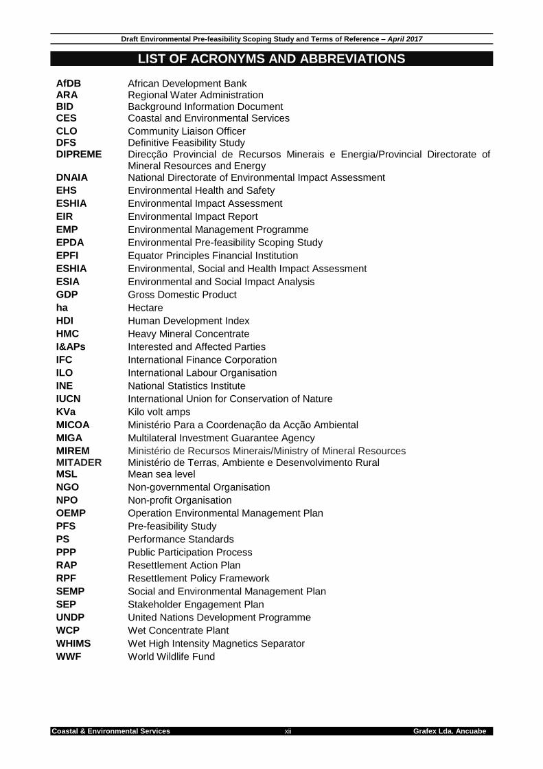
LIST OF ACRONYMS AND ABBREVIATIONS AfDB
African Development Bank
ARA BID
Regional Water Administration Background Information Document
CES Coastal and Environmental Services
CLO Community Liaison Officer DFS Definitive Feasibility Study DIPREME Direcção Provincial de Recursos Minerais e Energia/Provincial Directorate of
Mineral Resources and Energy DNAIA National Directorate of Environmental Impact Assessment
EHS Environmental Health and Safety
ESHIA Environmental Impact Assessment
EIR Environmental Impact Report
EMP Environmental Management Programme
EPDA Environmental Pre-feasibility Scoping Study
EPFI Equator Principles Financial Institution
ESHIA Environmental, Social and Health Impact Assessment
ESIA Environmental and Social Impact Analysis
GDP Gross Domestic Product
ha Hectare
HDI Human Development Index
HMC Heavy Mineral Concentrate
I&APs Interested and Affected Parties
IFC International Finance Corporation
ILO International Labour Organisation
INE National Statistics Institute
IUCN International Union for Conservation of Nature
KVa Kilo volt amps
MICOA Ministério Para a Coordenação da Acção Ambiental
MIGA Multilateral Investment Guarantee Agency
MIREM MITADER
Ministério de Recursos Minerais/Ministry of Mineral Resources Ministério de Terras, Ambiente e Desenvolvimento Rural
MSL Mean sea level
NGO Non-governmental Organisation
NPO Non-profit Organisation
OEMP Operation Environmental Management Plan
PFS Pre-feasibility Study
PS Performance Standards
PPP Public Participation Process
RAP Resettlement Action Plan
RPF Resettlement Policy Framework
SEMP Social and Environmental Management Plan
SEP Stakeholder Engagement Plan
UNDP United Nations Development Programme
WCP Wet Concentrate Plant
WHIMS Wet High Intensity Magnetics Separator
WWF World Wildlife Fund
Draft Environmental Pre-feasibility Scoping Study and Terms of Reference – April 2017
Coastal & Environmental Services 13 Grafex Lda. Ancuabe
1. INTRODUCTION 1.1. INTRODUCTION GRAFEX Lda. have proposed the development of the Ancuabe Graphite Project located in the district of Ancuabe in Cabo Delgado Province, northern Mozambique. The Ancuabe Graphite Project spans across three adjacent mining licenses (EL 5380, EL 5305 and EL5336) and all are included in this EPDA report. Graphite is classified by form, size and purity with flake graphite considered more desirable than amorphous graphite, and hence there are two main markets for graphite; 1) Amorphous (microcrystalline) graphite and 2) Flake (crystalline) graphite (Leak, 2014). Flake graphite is of a higher quality than amorphous graphite and can be used in traditional and hi-tech applications. By contrast, amorphous graphite can’t and it is therefore not suitable for refractories or batteries which are the two main drivers of the graphite sector. Flake graphite derives its value through the size of flake and the concentrate purity. Ancuabe graphite is known for its large flake size and properties to produce a high purity concentrate. High purity flake graphite commends a significant premium in the Lithium Iron Battery (LIB) market and large flake size graphite commands even higher prices for supply into the expandable graphite market. The target market regions include China and Asia, where the expandable graphite production facilities and Lithium ion battery upgrade facilities are located. In accordance with best practice, this scoping report is being undertaken at the start of the decision making process. This will ensure that alternative mining scenarios can be considered during the scoping phase, that potentially high impacts can be avoided through design and layout changes, and that process changes to mitigate impacts can be considered early on in the project. All this leads to a more environmentally appropriate and socially acceptable project. 1.2. THE PROPONENT Grafex Limitada (Grafex), a Mozambican company with a portfolio of five (5) graphite prospecting licenses in the Cabo Delgado Province of Mozambique and which have subsequently been converted to Exploration Licenses. Grafex Limitada (Grafex) is a subsidiary of Triton a diversified minerals exploration company in Australia listed on the Australian Securities Exchange (ASX). In 2012 Triton made an agreement to purchase an interest in the mineral tenements of Grafex and has to date acquired an 80% share of the shares of Grafex. Triton, via Grafex, aims to become a long term supplier to the premium graphite concentrate market via its projects in Mozambique, providing a sustainable future for several generations. The proponent for this project is Triton Minerals Limited: Mr Peter Canterbury CEO & Managing Director Triton Minerals Ltd Ground Floor, 10 Outram St WEST PERTH WA 6005 Tel: +61 8 6489 2555 Fax: +61 8 9388 1252 Email: [email protected] Website: www.tritonminerals.com
Draft Environmental Pre-feasibility Scoping Study and Terms of Reference – April 2017
Coastal & Environmental Services 14 Grafex Lda. Ancuabe
1.3. THE CONSULTANTS The document has been prepared by Coastal & Environmental Services Limited Mozambique Lda (CES) to meet the National Environmental Laws, as well as various international standards. CES is a company registered in Mozambique, with the Ministério de Terras, Ambiente e Desenvolvimento Rural (MITADER) (Appendix 2) and has solid knowledge and multidisciplinary teams to conduct environmental impact assessments and environmental management programs. The contact address of CES is: Ms Sonne Odendaal Avenida da Mozal, Porta 2334 Beluluane Celula D. Quarteirao 02, Matola Cidade, Maputo, Mozambique Tel.: +258 (84) 890 0914 Email: [email protected] Website: www.cesnet.co.za In conjunction with: Amber Jackson EOH Coastal and Environmental Services (CES) Suite 408, The Point 76 Regent Road Sea Point, 8005 South Africa. Telephone: +27 21 045 0900 Fax: +27 46 622 6564 Website: www.cesnet.co.za Email: [email protected] 1.4. EXPERTISE OF THE TEAM 1.4.1. EOH Coastal & Environmental Services ESHIA Management Team Dr Ted Avis – Project Leader / Reviewer Ted Avis is a leading expert in the field of Environmental Impact Assessments, having project-managed numerous large-scale ESHIAs to international standards (e.g. International Finance Corporation). Ted was principle consultant to Corridor Sands Limitada for the development of all environment aspects for the US$1billion Corridor Sands Project. Ted has also managed ESHIA studies and related environmental assessments of similar scope in Kenya, Madagascar, Egypt, Malawi, Zambia and South Africa. He has worked on large scale SEA’s in South Africa, and has been engaged by the International Finance Corporation (IFC) on a number of projects. Ted was instrumental in establishing the Environmental Science Department at Rhodes University whilst a Senior lecturer in Botany, based on his experience running honours modules in ESHIA practice and environmental. He is an Honorary Visiting Fellow in the Department of Environmental Sciences at Rhodes. He was one of the first certified Environmental Assessment Practitioner in South Africa, gaining certification in April 2004. He has delivered papers and published in the field of ESHIA, Strategic Environmental Assessment and Integrated Coastal Zone Management and has been a principal of CES since its inception in 1990, and Managing Director since 1998.

Draft Environmental Pre-feasibility Scoping Study and Terms of Reference – April 2017
Coastal & Environmental Services 15 Grafex Lda. Ancuabe
Ted holds a PhD in Botany, and was awarded a bronze medal by the South African Association of Botanists for the best PhD adjudicated in that year, entitled “Coastal Dune Ecology and Management in the Eastern Cape”. Ms Amber Jackson – Project Manager Amber is Environmental Consultant and has been employed with EOH CES for the last 3 years. She has an MPhil in Environmental Management and has a background in both Social and Ecological work. Her undergraduate degrees focused on Ecology, Conservation and Environment with particular reference to landscape effects on Herpetofauna, while her masters focused on the environmental management of social and ecological systems. With a dissertation in food security that investigated the complex food system of informal and formal distribution markets. During her time at CES Amber has worked extensively in Mozambique managing a number of Environmental and Social Impact Assessments. She has conducted two large scale (> $100 000.00) ESIA for Green Resources (forestry Plantation Company based in Mozambique) to both MITADER standards and International lenders standards in fulfilment with lender requirements (AfDB, EIB and IFC). Her interests include: ecological studies dealing with indigenous fauna and flora, as well as land use and natural resource management. Mr Justin Green – GIS Specialist & Report Production Justin as been employed with EOH CES for the last 3 years and has a BSc. degree in Zoology and Entomology as well as a Post Graduate Diploma in Enterprise Management from Rhodes University. Justin has been involved in extensive work in Renewable Energy and Mining Projects. Justin played an integral part in Environmental Impact Assessments as well as Basic Assessments in South Africa, numerous internationally based projects. Justin is also part of the Geographical Information Systems (GIS) team and is involved in the production of mapping data as well as tracking equipment for field work.
Draft Environmental Pre-feasibility Scoping Study and Terms of Reference – April 2017
Coastal & Environmental Services 16 Grafex Lda. Ancuabe
2. ESHIA PROCESS 2.1. THE ENVIRONMENTAL IMPACT ASSESSMENT PROCESS IN MOZAMBIQUE The ESHIA Process, regulated by Decree No. 54/2015, is applicable to all public and private activities. The Ministério de Terras, Ambiente e Desenvolvimento Rural (MITADER), through the Agencia Nacional para o controle de qualidade Aambiental (AQUA) is the authority responsible for environmental assessment. The first step in the ESHIA process in Mozambique is environmental screening to define the extent and type of environmental assessment required for a given project. Factors that are considered during the screening include:
Scale and type of project;
Location and sensitivity of the site;
Nature and magnitude of potential impacts. The Mozambican ESHIA Regulations (Article 3) defines three project categories and these in turn define the level of environmental assessment required. The project being considered here is a category A (Annexure I) project and is subject to a full ESHIA as defined by the regulations, due to the nature, scale and location of the proposed project. The Public Participation Process guidelines are set out in the Ministerial Decree No. 130/2006 and are compulsory for all Category A Projects. Article 14 of the Regulations on the Process of Environmental Impact Assessment defines the Public Participation Process as an activity that involves public hearings and consultation. The Public Participation Process implies delivery of timely information regarding projects to all directly and indirectly interested and affected parties, responding to public requests for explanations on the project and the formulation of suggestions. Public participation provides an opportunity for stakeholders to learn more about the proposed project and provide their opinions. These need to be incorporated into the ESHIA process and should be used to guide further phases of the assessment and help mitigate potential conflict situations early on in the planning process. There are effectively six (6) main steps in the ESHIA process: 2.1.1. Step 1: Pre-Evaluation (Application and Screening) All activities must be screened against Annexure I, II and III as defined in Article 4 of the Environmental Regulation in order to determine the project Category (A+, A, B or C) under which the proposed activity is to be assessed. Annex VI to the Environmental Impact Assessment regulation (the AIA Form) requires completion of a Preliminary Environmental Information Form before the ESHIA process is started. This form is structured as follows, and includes the following details:
Name of Activity
Identity of Applicant
Address, contact details
Location – Street; Town; Locality; District; Province
Type of area
Zoning Information
Description of Activity – Infrastructure; Associated Activities; Brief description of technology required for construction and operation; Type origin and quantity of labour; Type, origin and quantity of raw materials; Chemical Products to be used; Type,

Draft Environmental Pre-feasibility Scoping Study and Terms of Reference – April 2017
Coastal & Environmental Services 17 Grafex Lda. Ancuabe
quantity and origin of water and electricity to be used; Other resources required; Land holding (legal status of physical area required); Alternative locations (reason for choosing the proposed location and identification of at least two alternative locations); Brief environmental description of the area and region; Supplementary information in the form of maps and diagrams.
Date and signature of applicant. The AIA form was submitted to MITADER on 28 October 2015 and a copy is provided in Appendix 1. The Background Information Document (BID), which provides a more detailed preliminary description of the proposed development, is submitted as a separate document. 2.1.2. Step 2: Environmental Pre-feasibility Scoping Study and Terms of Reference An Environmental Pre-feasibility Scoping Study (EPDA) is obligatory for all Annexure I and II activities as defined by Article 10 of the ESHIA regulations. The key objectives of the phase as defined by the ESHIA regulations are to:
Determine any fatal flaws or environmental risks associated with the implementation of the activity.
Determine the scope of the ESHIA process and develop a Terms of Reference for this phase should no fatal flaws be identified.
An EPDA report should be produced and should, at the minimum include the following:
i. A non-technical summary highlighting the key issues and conclusions; ii. Details of the proponent and ESHIA study team; iii. Spatial extent of the proposed activity in terms of both direct and indirect influences
as well as the pre-development land use in this zone; iv. A description of the activity and the different actions to be undertaken, with respect to
possible alternatives at the planning, construction, exploration and decommissioning stages;
v. Identification of important biophysical and socio-economic characteristics of the affected environment;
vi. Identification of any potential fatal flaw; vii. Identification of potential environmental issues or impacts; and viii. Identification of aspects that need to be addressed in the ESHIA study phase. The Terms of Reference (ToR) describe in detail the issues to be investigated by each specialist study during the next phase of the ESHIA (Environmental Impact Report and Environmental Management Programme). 2.1.3. Step 3: Authority Review of the Environmental Pre-feasibility Scoping Study
and Terms of Reference The EPDA and ToR report will be presented in Portuguese to MITADER for review. The authority may request additional information, and should provide comment and recommendations in terms of the ESHIA study within 30 days of receiving the report. 2.1.4. Step 4: The Public Participation Process The Public Participation Process (PPP) involves consultation with the wider public. The process facilitates the dissemination of information about the project and identification of indirectly and directly Interested and Affected Parties (I&APs). The proponent is required to undertake the PPP throughout the ESHIA process. This includes providing sufficient advertising and allowing the opportunity for I&APs to participate

Draft Environmental Pre-feasibility Scoping Study and Terms of Reference – April 2017
Coastal & Environmental Services 18 Grafex Lda. Ancuabe
in public meetings. The PPP will be undertaken based on any directives given by the relevant authority and the results of the process will be summarised in a final public participation report according with Public Participation Process guidelines that are set out in the Ministerial Decree No. 130/2006. A public meeting must be advertised at least 15 days in advance, to which all I&APs must be invited and the technical reports of the EIR must be made available for public comment 2.1.5. Step 5: Environmental Impact Study and Environmental Management
Programme (EMPr) The ESHIA process is the responsibility of the proponent and the ESHIA team, and will be undertaken in line with the Terms of Reference set out in the EPDA. The study will be summarised in an Environmental Impact Report (EIR). In order to address the issues raised during the EPDA process, the ESHIA study will include specialist studies to provide a detailed and thorough examination of key environmental impacts. Once completed, these findings will be synthesized into the EIR and will be provided in full as a Specialist Study Volume. All specialist studies will include specific recommendations aimed at avoiding, or where this is not possible reducing negative impacts and maximizing positive impacts during the construction, operation and decommissioning phases of the proposed development. These recommendations will be synthesized into an Environmental Management Programme (EMPr). 2.1.6. Step 6: Authority Review of the Environmental Impact Report and
Environmental Management Programme The Environmental Impact Report, Specialist Studies Volume and Environmental Management Programme will be presented to MITADER for review. The review should be undertaken within 45 days of receiving the final reports. Upon completion of the review, MITADER will provide a final Record of Decision. Based on Article 19 of the ESHIA regulations this may be one of the following:
Positive record of decision;
Total rejection of the activity based on the outcomes of the reports and the final environmental impact statement;
Partial rejection of the activity based on the outcomes of the reports and the final environmental impact statement
In providing an environmental license, the relevant authority may seek to place conditions of approval that are legally binding on the proponent. Furthermore the authority may request changes to the project scope or additional ESHIA studies.

Draft Environmental Pre-feasibility Scoping Study and Terms of Reference – April 2017
Coastal & Environmental Services 19 Grafex Lda. Ancuabe
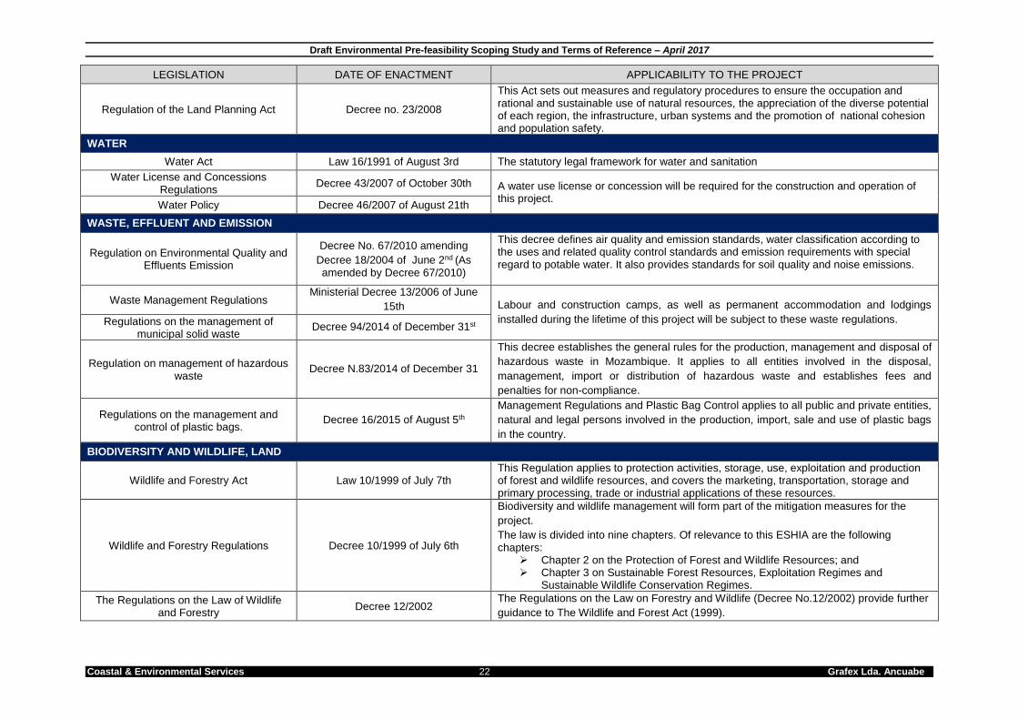
2.2. APPLICABLE MOZAMBICAN LEGISLATION A summary of the legislation applicable to the mining project is provided below in Table 7.1 below. It should be noted that the list provided below is not exhaustive, and has been restricted to documents that have direct relevance to either the environment and/or communities.
Box 1: Summary of ESIA process to be followed for a Category A project

Draft Environmental Pre-feasibility Scoping Study and Terms of Reference – April 2017
Coastal & Environmental Services 20 Grafex Lda. Ancuabe
Table 2.1: List of applicable legislation.
LEGISLATION DATE OF ENACTMENT APPLICABILITY TO THE PROJECT
NATIONAL LEGISLATION
Constitution of the Republic of Mozambique
2004 Dictates the right to environment for each citizen in article 90 no. 1: “All citizens shall have the right live in a balanced environment and shall have the duty to defend it”.
INDUSTRIAL LICENSING AND LABOUR LAW
General Investment Act Law 3/1993 of June 24th Mining Corporations are required to abide by the commercial laws of the operating country
Labour Act Law no. 23/2007 of August 1st Mining Corporations are required to abide by the labour regulations of the operating country
ENVIRONMENTAL FRAMEWORK LAW, EIA, INSPECTIONS AND AUDITS
Environment Act Law 20/1997 of October 1st (As
amended by the Decree 42/2008) The project will have an environmental impact, and, as such, will require an Environmental Impact Assessment.
Environmental Impact Assessment Regulations
Decree 54/2015 of December 31 The process and rules to be followed when conducting an Environmental Impact Assessment.
Addendum to the EIA Process Regulations no. 45/2004
Ministerial Diploma 198/2005 of September 28th The environmental authorization required prior to commencements of this project will be
regulated by the EIA legislation General Directive for EIA
Ministerial Diploma 129/2006 of July 19th
General Directive for the Public Participation Process in the EIA process
Ministerial Diploma 130/2006 of July 19th
Public participation forms a crucial part of the ESHIA process and is mandatory for category A+, A and B projects. At least two public consultation rounds must take place and a final public participation process report that addresses all questions, concerns and comments raised by I&APs must be submitted with the EIR to the authorities.
Regulations for Environmental Inspections
Ministerial Decree 11/2006 of June 15th
These regulations apply to both public and private activities influencing environmental components, either directly, or indirectly. In particular, the regulation defines the types and contents of environmental audits, the related necessary competences and auditors’ profiles. Moreover, it regulates environmental audit reports and defines sanctions and penalties for non-compliance.
Auditing and monitoring form crucial parts of the ESHIA process, and as such this act directly impacts upon the regulatory requirements to which the proponent must adhere
Environmental Audit Process Ministerial Decree 32/2003 of August
12th
Extracts from the Penal Code June 2015
These regulations define the consequences of environmental non-compliance and infringement on the proponent
Norms of application of fines and other sanctions prescribed in the Environmental
legislation
Ministerial Diploma 1/2006 of January 4th
Law on Crimes against the Environment Ministerial Diploma of 7/2005
SOCIAL

Draft Environmental Pre-feasibility Scoping Study and Terms of Reference – April 2017
Coastal & Environmental Services 21 Grafex Lda. Ancuabe
LEGISLATION DATE OF ENACTMENT APPLICABILITY TO THE PROJECT
Protection of the Mozambican Cultural Heritage
Decree 10/1988
The purpose of this law is to protect the tangible and intangible assets of the Mozambican cultural heritage – e.g. monuments, buildings of historical, artistic and scientific sites and natural elements of scientific interest and particular aesthetic. This law extends to any cultural assets that may be discovered on Mozambican territory, in particular, in the soil, subsoil, beds of inland bodies of water or the continental shelf.
Heritage Resources may be disturbed and impacted by the mining activities, and as such fall under the ambit of these regulations
Archaeological Heritage Decree 27/1994 of July 20th Heritage Resources may be disturbed and impacted by the mining activities, and as such fall under the ambit of these regulations Regulation on the Protection of the
Archaeological Heritage, Decree 27/97 of July 20th.
Regulation of Resettlement Process Resulting from Economic Activities
Decree 31/2012 of August 8
These regulations establish the basic rules and principles to guide the process of resettlement resulting from economic activities for both public and private initiatives This is done in order to provide an opportunity for improving the quality of life of project affected households. Article 4 provides a list of principles that guide the resulting resettlement process. These include the principles of social cohesion; social equity; direct benefits; social equity; no change in the level of income; public participation; environmental responsibility; and social responsibility.
Land Act Law19/97 of October 1st
Land appropriation and ownership rights are pivotal to project implementation. This act aims at establishing the terms under which the creation, extension, modification, transfer and termination of the right of land use and benefit operates. It regulates ownership of the land and public domain, the right of use and benefit of land, and the powers and responsibilities of the concerned public bodies. In particular, it defines obligations to be fulfilled by foreign or national entities, as well as fees to be paid in order to obtain a license for land exploitation
Land Act Regulations Decree 66/1998 December 8th (Amended by Decree 1/2003 of
February 18th)
Land appropriation and ownership rights are pivotal to the project implementation
Relevant aspects of the regulations include:
a) Where there is joint title, such title belongs to all the titleholders equally. When one of
the titleholders dies, the other holders continue as the rightful titleholders;
b) Consultations between the applicants for land and the local community are
mandatory before a decision to grant title use is made by the provincial governor or
higher authority;
c) Good faith occupiers and local communities may apply for demarcation and title; and
d) Titleholders are required to pay a tax for authorisation of the right to use land, plus an
annual tax. Family businesses and local communities are exempt from such taxes.
Land Planning Act Law 19/2007 of July 18th The Act defines the mechanisms for preparation, approval, implementation, monitoring
and supervision of land-use plans, as well as the responsibilities associated with this.
Draft Environmental Pre-feasibility Scoping Study and Terms of Reference – April 2017
Coastal & Environmental Services 22 Grafex Lda. Ancuabe
LEGISLATION DATE OF ENACTMENT APPLICABILITY TO THE PROJECT
Regulation of the Land Planning Act Decree no. 23/2008
This Act sets out measures and regulatory procedures to ensure the occupation and rational and sustainable use of natural resources, the appreciation of the diverse potential of each region, the infrastructure, urban systems and the promotion of national cohesion and population safety.
WATER
Water Act Law 16/1991 of August 3rd The statutory legal framework for water and sanitation
Water License and Concessions Regulations
Decree 43/2007 of October 30th A water use license or concession will be required for the construction and operation of this project.
Water Policy Decree 46/2007 of August 21th
WASTE, EFFLUENT AND EMISSION
Regulation on Environmental Quality and Effluents Emission
Decree No. 67/2010 amending
Decree 18/2004 of June 2nd (As
amended by Decree 67/2010)
This decree defines air quality and emission standards, water classification according to the uses and related quality control standards and emission requirements with special regard to potable water. It also provides standards for soil quality and noise emissions.
Waste Management Regulations Ministerial Decree 13/2006 of June
15th Labour and construction camps, as well as permanent accommodation and lodgings
installed during the lifetime of this project will be subject to these waste regulations. Regulations on the management of municipal solid waste
Decree 94/2014 of December 31st
Regulation on management of hazardous waste
Decree N.83/2014 of December 31
This decree establishes the general rules for the production, management and disposal of
hazardous waste in Mozambique. It applies to all entities involved in the disposal,
management, import or distribution of hazardous waste and establishes fees and
penalties for non-compliance.
Regulations on the management and control of plastic bags.
Decree 16/2015 of August 5th
Management Regulations and Plastic Bag Control applies to all public and private entities,
natural and legal persons involved in the production, import, sale and use of plastic bags
in the country.
BIODIVERSITY AND WILDLIFE, LAND
Wildlife and Forestry Act Law 10/1999 of July 7th This Regulation applies to protection activities, storage, use, exploitation and production of forest and wildlife resources, and covers the marketing, transportation, storage and primary processing, trade or industrial applications of these resources.
Wildlife and Forestry Regulations Decree 10/1999 of July 6th
Biodiversity and wildlife management will form part of the mitigation measures for the
project.
The law is divided into nine chapters. Of relevance to this ESHIA are the following chapters:
Chapter 2 on the Protection of Forest and Wildlife Resources; and Chapter 3 on Sustainable Forest Resources, Exploitation Regimes and
Sustainable Wildlife Conservation Regimes.
The Regulations on the Law of Wildlife and Forestry
Decree 12/2002 The Regulations on the Law on Forestry and Wildlife (Decree No.12/2002) provide further
guidance to The Wildlife and Forest Act (1999).

Draft Environmental Pre-feasibility Scoping Study and Terms of Reference – April 2017
Coastal & Environmental Services 23 Grafex Lda. Ancuabe
LEGISLATION DATE OF ENACTMENT APPLICABILITY TO THE PROJECT
National Strategy and Action Plan of Biological Diversity of Mozambique
(2015-2035)
The 2003 National Biodiversity Strategy Plan was updated by
MITADER in 2015.
The purpose of this report is to outline a strategy to ensure the conservation of biodiversity through integration, training, financing and the strengthening of partnerships between the different sectors of society.
Control of Exotic Invasive Species Act Law 25/2008 of 01 July Weed control required throughout the construction and operation phases will be directly regulated by this act.
Conservation Law Law 16/2015
MINING ACTIVITIES
Technical Safety Regulations and Health in Mining Geological Activities
Decree No. 61/2006 of 26 December
The purpose of these regulations is to define measures aimed at ensuring safety and health conditions of employees engaged in mining operations, including the application of technical measures that prevent accidents, lower professional risks and improve hygiene in the workplace in the mining sector.
Regulation of Foreign Nationality Citizens Hiring in Oil Sector and Mining
Decree n.º63 / 2011 of 7 December
Establishes the legal framework including the mechanisms and procedures for employing foreign nationals under the Petroleum and Mining Law, as long as those activities have been approved by the competent authority. Decree No. 63/2011 defines, that for short-term activities not exceeding 180 days, hiring of skilled foreign workers can be carried out without a permit from the Minister of Labour, provided the Ministry of Labour is notified within 15 days of the employee entering in the country.
The Mining Law 20/2014 of 18 August
The purpose of this law is to regulate the use and re-use of mineral resources to ensure that the best and safest mining and socio-environmental practices are adhered to, allow for transparency, the sustainable long term development of the countries mineral resources and the raising of revenues in favour of Mozambique.
Mining Law Regulations Ministerial Decree 20/2014 of 18
August
The purpose of this law is to regulate the use and re-use of mineral resources to ensure that the best and safest mining and socio-environmental practices are adhered to, allow for transparency, the sustainable long term development of the countries mineral resources and the raising of revenues in favour of Mozambique.
Environmental Regulations for Mining Activities
Ministerial Decree 26/2004 of August 20th
This law defines the norms for the prevention, control, mitigation and compensation of adverse effects that mining activities might cause to the environment. It also provides specific environmental protection measures, defines the required environmental management instruments (e.g. the EIA process) and defines the use of licenses.
Mining Working Regulations Decree 13/2015 of 03 July
The new regulation of mining work addresses a major gap in the legislation on professional work in this area that has generated employment for Mozambican citizens, although there are also a significant number of foreign workers in the sector. To fill the gap in the legislation, the Mozambican Government has approved the Mining Work Regulation through Decree 13/2015 of 3 July. The new regulation governs labour relations between mining and oil sector employers, including subcontractor companies, and their employees, whether Mozambican or foreign. It also provides for supervision of employment conditions.

Draft Environmental Pre-feasibility Scoping Study and Terms of Reference – April 2017
Coastal & Environmental Services 24 Grafex Lda. Ancuabe
2.3. INTERNATIONAL STANDARDS APPLIED TO THIS PROJECT 2.3.1. International Finance Corporation Performance Standards Frontier Rare Earths Limited have chosen to undertake this ESHIA to the International Finance Corporation (IFC) Performance Standards (PS). These standards are also environmental and social safeguards applied by the Multilateral Investment Guarantee Agency (MIGA). The IFC is a member of the World Bank Group, and one of the largest development institutions that focuses exclusively on the private sector in developing countries (IFC, 2012)1. The IFC was established in 1956 and works in developing countries to create job opportunities, generate tax revenue, improve corporate governance and, perhaps the most important of all, ensuring that projects contribute to the upliftment of its countries’ local communities. In respect of the latter, it is also the IFC’s vision for people to be presented with the opportunity to escape poverty and improve their standard of living. The IFC published its Performance Standards (PS) on Environmental and Social Sustainability in April 2006, and published comprehensive Guidance Notes in April 2007. The PSs were revised in 2012 (cf. IFC, 2012). The IFC's PSs are exclusively tailored for managing projects and general project requirements for IFC support. In addition to these standards, the IFC also published supporting Guidance Notes on each standard, which provides guidance to clients and the IFC staff in order for projects to effectively meet the PS. These performance standards (see Table 7.2) have become the international benchmark for ESHIA’s and are used to measure the environmental performance and management of large international projects. Table 2.2: IFC Performance Standards.
Performance Standard 1: Social & Environmental Assessment and Management Systems Performance Standard 2: Labour and Working Conditions Performance Standard 3: Pollution Prevention and Abatement Performance Standard 4: Community Health, Safety and Security Performance Standard 5: Land Acquisition and Involuntary Resettlement Performance Standard 6: Biodiversity Conservation & Sustainable Natural Resource
Management Performance Standard 7: Indigenous Peoples Performance Standard 8: Cultural Heritage
This ESHIA has been structured to meet the requirements of the IFC as outlined in the IFC’s Guidance Notes on Performance Standards on Social and Environmental Sustainability (IFC, 2012), as well as the IFC Environmental Health and Safety Guidelines for Mining (2007). In accordance with this, the ESHIA will be broadened to include social and health aspects, in accordance with IFC guidelines related to health assessment (IFC, 2009). Therefore this assessment has been referred to as an ESHIA, not an ESIA, to reflect the more detailed and broad approach used in this assessment.
Performance Standard 1 (PS 1) addresses the social and environmental assessment and management systems.
The primary objectives of PS 1 are to:
To identify and evaluate environmental and social risks and impacts of the project.
To adopt a mitigation hierarchy to anticipate and avoid, or where avoidance is not
possible, minimize, and, where residual impacts remain, compensate/offset for risks
and impacts to workers, Affected Communities, and the environment.
1 IFC. 2012. About IFC. [Online]. Available:
http://www1.ifc.org/wps/wcm/connect/115482804a0255db96fbffd1a5d13d27/PS_English_2012_Full-Document.pdf?MOD=AJPERES [2012, October 26].

Draft Environmental Pre-feasibility Scoping Study and Terms of Reference – April 2017
Coastal & Environmental Services 25 Grafex Lda. Ancuabe
To promote improved environmental and social performance of clients through the
effective use of management systems.
To ensure that grievances from Affected Communities and external communications
from other stakeholders are responded to and managed appropriately.
To promote and provide means for adequate engagement with Affected Communities
throughout the project cycle on issues that could potentially affect them and to
ensure that relevant environmental and social information is disclosed and
disseminated.
The main requirements of this standard are the development of environmental and social management programmes for the duration of the project. From a social perspective, the management programmes must at a minimum address health and safety, security, human resources, community engagement, labour and must address social management issues. All environmental, social and health impacts must be determined and ranked in terms of the risks they pose to the project.
All adverse impacts must be avoided and if this is not possible they must be minimised. Once the ESHIA process has been completed, a management programme must be compiled which outlines what mitigation measures are to be used, how they are to be implemented and how they will be monitored and evaluated. The management programme must outline the roles and responsibilities associated with implementation and monitoring requirements. The management programme should identify communication strategies to ensure community engagement throughout the project lifecycle. Generally a Stakeholder Engagement Plan (SP) is developed to achieve this requirement. Monitoring programmes must be periodically reviewed by internal and external parties to ensure compliance and for evaluation purposes. Performance Standard 2 (PS 2) addresses labour and working conditions. The primary objectives of PS 2 are to:
Establish, maintain, and improve the worker-management relationship.
Promote the fair treatment, non-discrimination and equal opportunity of workers, and compliance with national labour and employment laws.
Protect the workforce by addressing child labour and forced labour.
Promote safe and healthy working conditions.
Protect and promote the health of workers. Most of these issues are dealt with in the management plans required under PS 1. However, PS 2 outlines in detail what working conditions are acceptable and how worker relationships should be managed, and also deals with occupational health and safety for the project (addressed in various management plans). Certain activities (e.g. radiation, Mineral Separation Plant health and safety procedures, etc.) will need to be dealt with on an activity by activity basis. Performance Standard 3 (PS 3) addresses pollution prevention and abatement. The primary objectives of PS 3 are to:
Avoid or minimise adverse impacts on human health and the environment by avoiding or minimising pollution from project activities.
Promote the reduction of emissions that contribute to climate change.

Draft Environmental Pre-feasibility Scoping Study and Terms of Reference – April 2017
Coastal & Environmental Services 26 Grafex Lda. Ancuabe
The primary requirement of PS 3 is that technologies and practices which avoid or minimise detrimental impacts of pollution are applied throughout the lifecycle of the project. In addition to the EHS General Health and Safety Guidelines, the IFC has sector specific guidelines which deal with pollution and human health issues associated with mining (IFC Environmental Health and Safety Guidelines for Mining,30 April 2007).These guidelines will be used for this project and included in the management plans. Performance Standard 4 (PS 4) addresses community health, safety and security. The primary objectives of PS 4 are to:
Avoid or minimise risks to, and impacts on, the health and safety of the local community during the project lifecycle from both routine and non-routine circumstances.
Ensure that the safeguarding of personnel and property is carried out in a legitimate manner that avoids or minimises risks to the community’s safety and security.
The major requirement in terms of PS 4 is that all risks and impacts to the surrounding community are assessed and managed appropriately. This includes issues such as infrastructure and equipment safety, hazardous material storage and handling, hazards associated with the natural environment (e.g. floods, landslides, etc.), community exposure to disease and emergency preparedness and response. Performance Standard 5 (PS 5) addresses land acquisition and involuntary resettlement. The primary objectives of PS 5 are to:
Avoid or at least minimise involuntary resettlement wherever feasible by exploring alternative project designs and layouts.
Mitigate adverse social and economic impacts from land requisition or restrictions on affected persons’ use of land by (i) providing compensation for loss of assets at replacement cost; and (ii) ensuring that resettlement activities are implemented with appropriate disclosure of information, consultation and the informed participation of those affected.
Improve or at least restore the livelihoods and standards of living of displaced persons.
Improve living conditions among displaced persons through provision of adequate housing with security of tenure at resettlement sites.
Consistent with the objectives and requirements of PS 5, a Resettlement Plan (as per the requirements of Decree 31/2012) will be produced as part of this ESHIA process. Prior to the preparation of the Resettlement Plan, a process of physical and socioeconomic data capture and analysis will take place. This will inform the elaboration of the Resettlement Plan, which will include the following elements:
a) Analysis of the socioeconomic profile of the affected households; b) Evaluation and analysis of the tangible and intangible and intangible goods; c) Definition of the degree of affectation – quantitative and qualitative; d) Definition of the compensation criteria; e) Presentation of solutions and technical alternatives and viable economically that enable to keep or improve the current living standard of the affected households.
The Resettlement Plan informs the pre-implementation phase of the project and provides the detailed foundation for the preparation of a full Resettlement Action Plan (RAP), which will be developed for all affected communities. PS5 will only be addressed fully once a RAP is undertaken. The Resettlement Plan forms part of the present ESHIA, while the Action Plan for the Implementation of the Resettlement Plan (RAP) will form a separate study to the present ESHIA.
Draft Environmental Pre-feasibility Scoping Study and Terms of Reference – April 2017
Coastal & Environmental Services 27 Grafex Lda. Ancuabe
Performance Standard 6 (PS 6) deals with biodiversity conservation and sustainable natural resource management. The primary objectives of PS 6 are to:
Protect and conserve biodiversity.
Promote the sustainable management and use of natural resources through the
adoption of practices that integrate conservation needs and development priorities.
In order to conform to PS 6, the study has to consider ecosystem goods and services afforded by the natural environment in the project area. This assessment has to include an investigation into provisioning services, regulating services and cultural services. A biodiversity monitoring plan will be produced at a later stage to demonstrate how the project will monitor the plant and animal biodiversity in the project area to ensure it is properly managed and conserved. This plan will outline the monitoring and evaluation required to manage ecological aspects. Specialist studies that focus on the biological environment (e.g. fauna, flora and fish surveys) will assess the status of the environment and determine whether this should be classified as modified, natural or critical habitat based on the guidelines presented in PS 6. The type of habitat will then inform the type of mitigation measures that are implemented. For example, in areas of natural habitat, mitigation measures will be designed to achieve no net loss of biodiversity. Performance Standard 7 (PS 7) deals with indigenous peoples and does not apply to this project. This is because indigenous peoples are defined as: “A distinct social or cultural group possessing the following characteristics in varying degrees:
Self-identification as members of a distinct indigenous cultural group and recognition of this identity by others
Collective attachment to geographically distinct habitats or ancestral territories in the project area and to the natural resources in these habitats and territories.
Customary cultural, economic, social or political institutions that are separate from those of the dominant society or culture
An indigenous language, often different from the official language of the country or region.”
This definition does not apply to the people in the project area. Performance Standard 8 (PS 8) addresses cultural heritage. The primary objectives of PS 8 are to:
Protect cultural heritage from adverse impacts of project activities and support its preservation.
Promote the equitable sharing of benefits from the use of cultural heritage in business activities.
Cultural heritage must be protected during the project, and care taken to ensure that cultural practises which the communities partake in are not impacted upon negatively as a result of the project. This will be investigated further during the specialist studies phase. 2.3.2. IFC General EHS Guidelines The IFC General EHS guidelines (30 April 2007) are applicable to this project. The guidelines detail general impacts and ways to manage them. They cover environmental, occupational health and safety, community health and safety, performance indicators, and

Draft Environmental Pre-feasibility Scoping Study and Terms of Reference – April 2017
Coastal & Environmental Services 28 Grafex Lda. Ancuabe
monitoring. 2.3.3. IFC EHS Guidelines for Mining The IFC EHS Guidelines for Mining (10 December 2007) are applicable to this project. The guidelines detail industry-specific impacts and ways to manage them. They cover environmental, occupational health and safety, community health and safety, performance indicators, and monitoring. 2.4. INTERNATIONAL CONVENTIONS Mozambique is a signatory to a number of international conventions. Those applicable to this project are summarised in Table 2.3 below. Table 2.3: International conventions applicable to the project.
INTERNATIONAL CONVENTIONS
Basel Convention on the Control of Transboundary Movements of Hazardous Wastes and their Disposal
1989
African Convention on the Conservation of Nature and Natural Resources 1968
(Amended)-Revised African Convention on the Conservation of Nature and Natural Resources (Amended Version) Not yet in force. Mozambique is a party and would be bound upon entry into force
2003
Constitutive Act of the African Union 2000
Bamako Convention on the Ban of the Import into Africa and the Control of Transboundary Movement and Management of Hazardous Wastes within Africa
1991
Convention on Biological Diversity 1992
Convention on International Trade in Endangered Species of Wild Fauna and Flora (Cites)
1973
UN Convention Concerning the Protection of World Cultural and Natural Heritage 1972
Kyoto Protocol to the UN Framework Convention on Climate Change 1998
Convention on Oil Pollution Preparedness, Response and Cooperation 1990
Convention on Wetlands of International Importance Especially as Waterfowl Habitat (RAMSAR)
1971
Stockholm Convention on Persistent Organic Pollutants 2001
UN Framework Convention on Climate Change (read with Kyoto Protocol) 1992
Vienna Convention for the Protection of the Ozone Layer 1985
International Convention on Civil Liability for Oil Pollution Damage 1992
Montreal Protocol on Substances that Deplete the Ozone Layer 1987
United Nations Convention on the Law of the Sea 1982
International Convention to Combat Desertification in Countries Experiencing Serious Drought and/or Desertification, Particularly in Africa
1994
Treaty Establishing the African Economic Community 1991
SADC Protocol on Mining 1997
African Charter on Human and Peoples’ Rights 1981
Convention on Safety of Life at Sea (SOLAS) 1974
Marpol 73/78, International Convention for the Prevention of Pollution From Ships, modified by the Protocol of 1978
1973, 1978
Convention on the Prevention of Marine Pollution by Dumping of Wastes and Other Matter and the 1996 Protocol Thereto
1972, 1996

Draft Environmental Pre-feasibility Scoping Study and Terms of Reference – April 2017
Coastal & Environmental Services 29 Grafex Lda. Ancuabe
3. PROJECT DESCRIPTION
3.1. INTRODUCTION AND PROJECT BACKGROUND Triton Minerals Limited (“Triton”) is a diversified minerals exploration company with assets in Australia and Africa, with their head office in Australia. In 2012, Triton entered into a Joint Venture agreement with Grafex Limitada (Grafex), a Mozambican company with a portfolio of five (5) graphite prospecting licenses in the Cabo Delgado Province of Mozambique which have subsequently been converted to Exploration Licenses. In December 2012 Triton Minerals entered into agreements to acquire an interest in the mineral tenements of Grafex. Currently Triton owns an 80% interest in Grafex and the mineral tenements held by Grafex. Grafex Lda. has proposed the development of a graphite mine and processing plant to produce high purity graphite concentrate. The Grafex Ancuabe project site is located west of the city of Pemba and south east of Ancuabe in the district of Ancuabe, Cabo Delgado (Figure 3.1). A technical scoping study was commissioned by Grafex Lda. and completed in April 2017. In addition, feasibility studies that include metallurgical test work were commissioned in April 2017 and are expected to be completed by November 2017. The Grafex Ancuabe project area spans three adjacent exploration licenses (EL5305, EL5336, EL 5380) currently held by Grafex. Combined, three areas cover approximately 51,094ha however the project area DUAT applications for this project will cover a much smaller area of approximately 11,368ha. The exact size of the pit that will be mined is still to be determined and will depend on the outcome of the resource surveys that are currently being undertaken. The majority of the project area is currently comprised of natural vegetation with few machambas located along the proposed access road and powerline corridor. Initial drilling has commenced at the project site. There is very little in the way of infrastructure which is limited to mobile offices, storage facilities for drilling equipment and temporary shelters for shade. However, a relatively large number of roads and drill pads have been established in the localised area where drilling has taken place. Despite this the project site is considered to be a Greenfields site. 3.2. RATIONALE FOR THIS DEVELOPMENT After the civil war (1977-1992) Mozambique emerged as one of the world’s poorest countries. Since then Mozambique has become one of Africa’s fastest growing economies with average annual growth rates of above 7%. This has been driven by political stability, macroeconomic stability, foreign direct investments (FDI), structural reforms and reconstruction. Mozambique’s economy is based primarily on agriculture which accounts for 83% of employment and 23% of GDP. However, most of this agriculture is at a subsistence level and hence people are “self-employed”. The mining industry provides a modest contribution towards the GDP but this has grown over the years (1.5% in 2012, 3.4% in 2012 and 4.3% in 2013). The growth between 2012 and 2013 can be attributed to an increase in coal production and exports, large infrastructure projects and credit expansion in the private sector. GDP from mining in Mozambique decreased from 6186 MZN Million in the third quarter of 2016 to 4272 MZN Million in the fourth quarter of 2016. GDP From Mining in Mozambique averaged 2448.08 MZN Million from 2008 until 2016, reaching an all-time high of 6186 MZN Million in the third quarter of 2016 and a record low of 844 MZN Million in the fourth quarter of 20082.
2 http://www.tradingeconomics.com/mozambique/gdp-from-mining
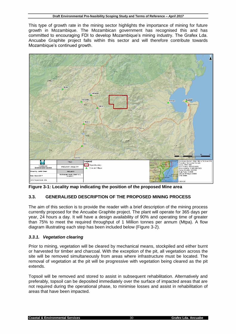
Draft Environmental Pre-feasibility Scoping Study and Terms of Reference – April 2017
Coastal & Environmental Services 30 Grafex Lda. Ancuabe
This type of growth rate in the mining sector highlights the importance of mining for future growth in Mozambique. The Mozambican government has recognised this and has committed to encouraging FDI to develop Mozambique’s mining industry. The Grafex Lda. Ancuabe Graphite project falls within this sector and will therefore contribute towards Mozambique’s continued growth.
Figure 3-1: Locality map indicating the position of the proposed Mine area 3.3. GENERALISED DESCRIPTION OF THE PROPOSED MINING PROCESS The aim of this section is to provide the reader with a brief description of the mining process currently proposed for the Ancuabe Graphite project. The plant will operate for 365 days per year, 24 hours a day. It will have a design availability of 90% and operating time of greater than 75% to meet the required throughput of 1 Million tonnes per annum (Mtpa). A flow diagram illustrating each step has been included below (Figure 3-2). 3.3.1. Vegetation clearing
Prior to mining, vegetation will be cleared by mechanical means, stockpiled and either burnt or harvested for timber and charcoal. With the exception of the pit, all vegetation across the site will be removed simultaneously from areas where infrastructure must be located. The removal of vegetation at the pit will be progressive with vegetation being cleared as the pit extends. Topsoil will be removed and stored to assist in subsequent rehabilitation. Alternatively and preferably, topsoil can be deposited immediately over the surface of impacted areas that are not required during the operational phase, to minimise losses and assist in rehabilitation of areas that have been impacted.
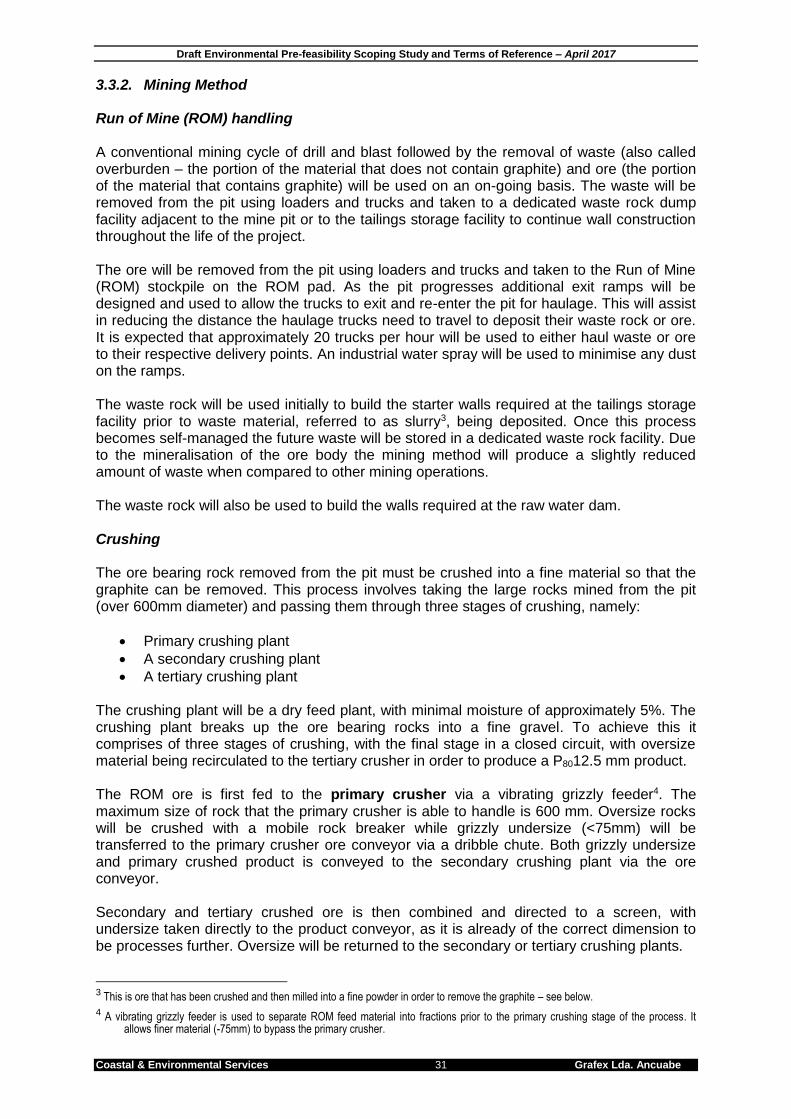
Draft Environmental Pre-feasibility Scoping Study and Terms of Reference – April 2017
Coastal & Environmental Services 31 Grafex Lda. Ancuabe
3.3.2. Mining Method Run of Mine (ROM) handling A conventional mining cycle of drill and blast followed by the removal of waste (also called overburden – the portion of the material that does not contain graphite) and ore (the portion of the material that contains graphite) will be used on an on-going basis. The waste will be removed from the pit using loaders and trucks and taken to a dedicated waste rock dump facility adjacent to the mine pit or to the tailings storage facility to continue wall construction throughout the life of the project. The ore will be removed from the pit using loaders and trucks and taken to the Run of Mine (ROM) stockpile on the ROM pad. As the pit progresses additional exit ramps will be designed and used to allow the trucks to exit and re-enter the pit for haulage. This will assist in reducing the distance the haulage trucks need to travel to deposit their waste rock or ore. It is expected that approximately 20 trucks per hour will be used to either haul waste or ore to their respective delivery points. An industrial water spray will be used to minimise any dust on the ramps. The waste rock will be used initially to build the starter walls required at the tailings storage facility prior to waste material, referred to as slurry3, being deposited. Once this process becomes self-managed the future waste will be stored in a dedicated waste rock facility. Due to the mineralisation of the ore body the mining method will produce a slightly reduced amount of waste when compared to other mining operations. The waste rock will also be used to build the walls required at the raw water dam. Crushing The ore bearing rock removed from the pit must be crushed into a fine material so that the graphite can be removed. This process involves taking the large rocks mined from the pit (over 600mm diameter) and passing them through three stages of crushing, namely:
Primary crushing plant
A secondary crushing plant
A tertiary crushing plant The crushing plant will be a dry feed plant, with minimal moisture of approximately 5%. The crushing plant breaks up the ore bearing rocks into a fine gravel. To achieve this it comprises of three stages of crushing, with the final stage in a closed circuit, with oversize material being recirculated to the tertiary crusher in order to produce a P8012.5 mm product. The ROM ore is first fed to the primary crusher via a vibrating grizzly feeder4. The maximum size of rock that the primary crusher is able to handle is 600 mm. Oversize rocks will be crushed with a mobile rock breaker while grizzly undersize (<75mm) will be transferred to the primary crusher ore conveyor via a dribble chute. Both grizzly undersize and primary crushed product is conveyed to the secondary crushing plant via the ore conveyor. Secondary and tertiary crushed ore is then combined and directed to a screen, with undersize taken directly to the product conveyor, as it is already of the correct dimension to be processes further. Oversize will be returned to the secondary or tertiary crushing plants.
3 This is ore that has been crushed and then milled into a fine powder in order to remove the graphite – see below.
4 A vibrating grizzly feeder is used to separate ROM feed material into fractions prior to the primary crushing stage of the process. It allows finer material (-75mm) to bypass the primary crusher.
Draft Environmental Pre-feasibility Scoping Study and Terms of Reference – April 2017
Coastal & Environmental Services 32 Grafex Lda. Ancuabe
The secondary crusher operates as a Closed Side Setting (CSS) to produce a product size P95 75 mm, which are small rocks the size of a closed fist. The tertiary crusher plant will produce product size of approximately P80 12.5 mm. This material is the size of a small pebble, and smaller than the aggregate typical produced for road construction. Tertiary crushed product is recirculated to the dry screening plant via the crushed product conveyor and oversize is re-crushed until it undergoes the required size reduction. Tramp metal5 will be removed using an overhead magnet on the primary crusher feed. A tramp metal detector will be installed on the primary crusher discharge conveyor in order to protect the downstream conveyors, screen and crushing equipment. Dust suppression sprays are located on conveyors and transfer chutes around the crushing plant to mitigate against airborne dust. Milling Milling is the process when the crushed ore, which is now the size of small pebbles, is crushed further into a material almost as fine as sand. The crushed ore is conveyed to the crushed ore bin. It is reclaimed from the bin using a single variable speed belt feeder which discharges onto the mill feed conveyor. In addition the feed bin is fitted with an overflow chute to generate an additional stockpile of crushed ore to maintain feed to the mill during periods when the crusher is under maintenance. Ore is recovered from the crushed ore bin using a belt feeder and discharges onto the mill feed conveyor. Ore is then fed into the rod mill in closed circuit with vibrating screens where the mill discharges on to double deck vibrating screens equipped with water sprays. The screen undersize P95 710 µm is pumped to the flotation circuit and the screen oversize is recycled back to the mill via conveyors (Figure 3.2). Flotation Flotation is the process of taking the milled sand and placing it into a large tank filled with liquid so that the graphite, which is lighter than the sand, can be separated off. Flotation feed (the milled “sand”) is pumped to the flotation conditioning tank and reagents consisting of Diesel or a specialty collector, and Methyl Isobutyl Carbinol (MIBC) frother are added6. The feed then gravitates to the rougher flotation circuit, which comprises conventional flotation cells. The rougher concentrate is fed to the first of the cleaning stages via an attritioning step. Rougher tailings gravitate to the tailings thickener, and attritioned rougher concentrate is pumped to the cleaner flotation circuit. All cleaner circuits comprise conventional flotation cells. Rougher concentrate and cleaner 2 tailings are combined in cleaner 1. Tailings from cleaner 1 are pumped to the tailings thickener (Figure 3.2).
5 Tramp metal are small pieces of metal that have broken off the crushers. Fine tramp metal can be described as metal dust or filings. Medium
tramp metal may include nuts, bolts, and broken grinding blades. Large tramp metal may consist of pieces of angle iron and broken
machinery parts.
6 The kerosene is used to collect the graphite particles and the frother is used to enhance the stability of the bubbles that float to the top of the flotation cells, and is collected as it overflows into concentrate collection launders. Both reagents are organic in composition and become inert due to pumping and significant dilution as the quantities added are minor compared to the volumes of slurry.
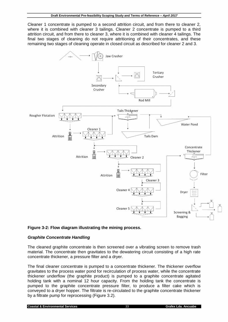
Draft Environmental Pre-feasibility Scoping Study and Terms of Reference – April 2017
Coastal & Environmental Services 33 Grafex Lda. Ancuabe
Cleaner 1 concentrate is pumped to a second attrition circuit, and from there to cleaner 2, where it is combined with cleaner 3 tailings. Cleaner 2 concentrate is pumped to a third attrition circuit, and from there to cleaner 3, where it is combined with cleaner 4 tailings. The final two stages of cleaning do not require attritioning of their concentrates, and these remaining two stages of cleaning operate in closed circuit as described for cleaner 2 and 3.
Figure 3-2: Flow diagram illustrating the mining process. Graphite Concentrate Handling The cleaned graphite concentrate is then screened over a vibrating screen to remove trash material. The concentrate then gravitates to the dewatering circuit consisting of a high rate concentrate thickener, a pressure filter and a dryer. The final cleaner concentrate is pumped to a concentrate thickener. The thickener overflow gravitates to the process water pond for recirculation of process water, while the concentrate thickener underflow (the graphite product) is pumped to a graphite concentrate agitated holding tank with a nominal 12 hour capacity. From the holding tank the concentrate is pumped to the graphite concentrate pressure filter, to produce a filter cake which is conveyed to a dryer hopper. The filtrate is re-circulated to the graphite concentrate thickener by a filtrate pump for reprocessing (Figure 3.2).
Draft Environmental Pre-feasibility Scoping Study and Terms of Reference – April 2017
Coastal & Environmental Services 34 Grafex Lda. Ancuabe
From the dryer hopper, graphite concentrate is fed into a dryer complete with bag house and exhaust fan. The dried product is then transferred to a bulk graphite holding bin. The graphite is fed to a line-up of enclosed screens to separate the graphite into five sized products:
1. Flake > 300 μm 2. 300 μm > Flake >180 μm 3. 180 μm > Flake >150 μm 4. 150 μm > Flake >106 μm 5. Fines <106 μm
Each sized product will be transported to their respective storage bins. Each storage bin will discharge to the bagging system. The bagging system is designed for 1 ton capacity bags and will include a hopper and feeder with dust collection, a bag handler, load cells and pallet roller conveyor. Full bags will be handled using a forklift and pallets. Bagged concentrate products will be stored undercover and loaded into containers for shipment. Tailings Tailings is the sand material that is left after the graphite has been separated from it. Large quantities of tailings are produced from the rougher and cleaner flotation circuits, and this is transferred to a tailings thickener where flocculent is added to the tailings thickener feed. The flocculent is an organic long chain polymer or a metallic sulphate such as Aluminium sulphate which creates the charge necessary to attract and collect fine particles which affect the clarity of water used in the processing. These are commonly used in swimming pools and water treatment plants and are harmless. They naturally break down through the pumping action and sun light. The tailings are then pumped to the tailings storage facility (TSF) which will comprise two cells for a 20 year mine life. A third cell and extension of the existing cells will be used for mine life beyond 20 years. The tailings are discharged using sub-aerial deposition from multiple spigots located around the embankment crest, much like an agricultural irrigation and sprinkler system. Thickener overflow water will gravitate to the process water pond for recycling. Additional water is recovered from the surface of the TSF via a tailings return water system, which is then returned to the plant for reuse. The intent is to maximise water recovery and reuse throughput the project. Reagents Reagents used in the process will include the following:
Diesel used as a collector for graphite,
Methyl Isobutyl Carbinol (MIBC) used as a frother for graphite,
Sodium silicate used as a depressant in graphite cleaning,
Flocculent used as a settling and filtration aid for concentrates and tailings,
Forged steel 50-100 mm rods for the primary rod mill and 5-10mm ceramic media for the attrition mills, with option to use pebble or silica media.

Draft Environmental Pre-feasibility Scoping Study and Terms of Reference – April 2017
Coastal & Environmental Services 35 Grafex Lda. Ancuabe
3.3.3. Infrastructure The following infrastructure will be required and will be assessed during the ESHIA:
Site roads providing access from existing gravel access roads to the proposed mining camp, plant, office buildings, maintenance yards, water storage, tailings storage and other infrastructure;
A lay-down area for construction materials and equipment of approximately 250 m x 250 m in total, across several locations. This area will continue to be used during the operational phase, although the actual area of land required may be reduced to an area of approximately 100 m x 100 m;
Accommodation camp during the construction period for approximately 200 persons;
Mining Camp to accommodate approximately 100 persons in single person housing facilities for the operational phase;
Small clinic for staff and contractors;
Site offices located adjacent to the plant. The exact dimensions and location will be determined as the project advances and more details are known;
Site services including bunded fuel storage areas and fuelling station, potable water treatment facility, sewage treatment facility, mine explosive storage facility and plant laboratory;
A perimeter fence around the power station including power switchyard and transformers and camp will be established; and
A process plant that includes a plant workshop and store, reagent and consumable storage, control room, crib and change rooms, plant offices, power station, switchyard and transformers and mobile plant.
A Landfill site will be required as mining operations will generate general solid wastes (food, glass, paper, wood, metal, oils and lubricants) which will need to be disposed appropriately in designated waste sites. The site for the landfill will be determined based on environmental suitability to prevent leachates etc.
In addition, the Ancuabe Graphite project will include:
Tailings storage facility.
Waste rock dumps comprising up to 83 Mt7 in the first 30 years of operation.
Raw water dam with approximately a 2 Mm3 capacity.
7 10 y x 2.3 Mtpa + 20 y x 3 Mtpa = 83 Mt minimum

Draft Environmental Pre-feasibility Scoping Study and Terms of Reference – April 2017
Coastal & Environmental Services 36 Grafex Lda. Ancuabe
Figure 3-3: Map illustrating the project boundary (red outline) for the proposed infrastructure and haul road
Draft Environmental Pre-feasibility Scoping Study and Terms of Reference – April 2017
Coastal & Environmental Services 37 Grafex Lda. Ancuabe
3.3.4. Water and Power Supplies Water It is estimated that the project will use approximately 1m3 (1000 litres) of water per tonne of plant feed (1 Mm3 annually). This water is required mainly for the flotation process and will be sourced from an in-channel raw water dam to be constructed on the Mogido River. This dam will be filled through natural run-of river flow, and must be sufficient large to provide enough water during the long dry season. Raw water will be pumped directly to the process plant, the potable water treatment plant and to mine services. A raw water tank will be constructed at the plant site to supply the fire water ring main water system, which supplies hose reels and fire hydrant points around the plant. The potable water treatment plant and tank storage facility will supply the water needs for staff personnel and water for safety showers located around the site. Additional water sources include water from the mine pit dewatering (internal and external), storage of surface water runoff and water reclaimed from the tailings storage facility. The exact source(s) of water will be determined as an outcome of the feasibility study investigations which are currently underway. Power It is estimated that the total annual plant demand for the mine will be up to 50 000 MWh. Power for the site will be obtained from the National Grid subject to availability and approval by the Mozambique Electricity Authority (EDM). The nearest transmission line is approximately 15km from the project area. Transmission of the power feed around the project area will be provided by transmission lines and substations as required. Diesel powered generators will, however, be installed as an alternative power source during times when the national grid is unable to supply a reliable source of power, or in the event that power from EDM cannot be delivered in time. Under this scenario the generators will not serve as back-up power, but will run 24/7. The noise and air quality impacts of this worst case scenario will be modelled and assessed in the ESHIA. 3.3.5. Transport It is estimated that ten 25 tonne trucks will be used to transport the product from the mine site to Pemba or Nacala Port each day. An additional five trucks will be required for spares and consumables (including diesel). Thus, there will be 30 trucks departing, and 30 truck arriving on a daily basis. In addition, two buses will be used to transport labour to and from site on an eight hour cycle. Light delivery vehicles will also be used for the general running of the mine. 3.4. EMPLOYMENT OPPORTUNITIES During the construction phase it is estimated that there will be up to 500 workers on site at the peak of the construction phase, which is estimated to take approximately 12 months from start of construction to commissioning. The breakdown of skill sets is as follows: 150 semi-skilled workers all sourced from local villages; 250 skilled workers sourced mainly from Mozambican and South African contracting companies; and 100 supervisory and management positions which will come from South African contracting companies. All workers will work a 6 week on 2 weeks off rotation working 9 hours a day, every day including Sundays.

Draft Environmental Pre-feasibility Scoping Study and Terms of Reference – April 2017
Coastal & Environmental Services 38 Grafex Lda. Ancuabe
Local staff will return home every night using transport provided by the company. Additional to the construction staff will be the support staff who will man security, assist with catering, site management, transport and laundry. All non-local staff will be housed in a construction camp situated on site and managed by a catering contractor. During the operational phase approximately 200 people will be employed on the mine. This will comprise of: up to 75 mining staff; 100 process and maintenance staff; and 25 service /admin staff. For the first two years the expat compliment will be 10% but will be reduced to 4-6% by year four. The majority of staff will be transported back to collection points through company provided transport and a small group of expat and regional workers will be housed in a reduced sized accommodation camp on site, working a 6 week rotation, similar to the construction phase. Table 3.1: Skilled, semi-skilled and unskilled labour likely to be employed during the construction and operational phases of the project. These numbers represent the maximum number of individuals that will be employed.
Type Construction Phase Operation Phase
Skilled 250 50
Semi-Skilled 150 50
Unskilled 50 100
Total 500 200
3.5. PROJECT ALTERNATIVES One of the objectives of an ESHIA is to investigate alternatives to the proposed project. There are two types of alternatives – Fundamental Alternatives and Incremental Alternatives. Alternatives are defined as: “different means of meeting the general purpose and requirements of the activity” which includes alternatives to the:
location - where the proposed activity will be;
type of activity to be undertaken;
design or layout of the activity;
technology to be used in the activity; and
operational aspects of the activity. 3.5.1. Fundamental Alternatives Fundamental alternatives are developments that are totally different from the proposed project and usually involve a different type of development on the proposed site, or a different location for the proposed development. A different type of development There is no alternative for this type of development, as the graphite found in the project area can only be used if it is mined as described above. There is no alternative that is practically or economically viable for Mozambique to export the graphite. Furthermore, Grafex Lda. wish to develop a graphite mine, and are consequently not interested in any other type of development. A different location Grafex Lda. have identified economical graphite deposits within their concession area and can only develop a mining operation in areas with mineralisation. Furthermore, the mine and the process plant must be as close to each other as possible, so the plant cannot be located at a different site.
Draft Environmental Pre-feasibility Scoping Study and Terms of Reference – April 2017
Coastal & Environmental Services 39 Grafex Lda. Ancuabe
The “No-Go” Alternative According to the ESHIA Regulations, the option of doing nothing – not proceeding with the proposed development (i.e. the No Go Option) must be assessed during the ESHIA. 3.5.2. Incremental Alternatives
Incremental alternatives are modifications or variations to the design of a project that provide different options to reduce or minimise environmental impacts and maximise benefits. There are several incremental alternatives that can be considered, including:
The design or layout of the activity;
The technology to be used in the activity; and
The operational aspects of the activity. Design Design alternatives can include different types of infrastructure, which have not been finalised by the applicant at this stage. Layout of Plant Site As the project is at scoping level, the layout of the project is not fixed or entirely accurate for the time being. A preliminary layout indicating the position of the resource, plant site and power and water corridors has been included (Figures 3-4 and 3-5). Potential layout alternatives will be further investigated during the ESHIA. Technology As with the layout, due to the stage of the project the technology is not fixed or entirely accurate for the time being. The proposed technology is based on current understanding and market requirements. It could change, and any changes will be assessed as alternatives in this ESHIA.

Draft Environmental Pre-feasibility Scoping Study and Terms of Reference – April 2017
Coastal & Environmental Services 40 Grafex Lda. Ancuabe
4. DESCRIPTION OF THE BIOPHYSICAL ENVIRONMENT Mozambique is located along the eastern coast of southern Africa between 10o27’ and 26o52’’ South and 30o12’ and 40o51’ East. It is bordered by South Africa, Swaziland, Zimbabwe, Zambia, Malawi and Tanzania and has a surface area of 799 380 km2 (Ribeiro and Chauque; 2010). The proposed Ancuabe Graphite Project area occurs in the district of Ancuabe within the northern province of Cabo Delgado in northern Mozambique. The project area is accessible by road 75 km west of Pemba along a tarred highway. There is currently more graphite in the Cabo Delgado province of Mozambique than the rest of the world’s graphite resources combined. 4.1. PHYSICAL ENVIRONMENT 4.1.1. Climate The climate in northern Mozambique is tropical humid and is characterized by distinct rainy season and dry season and an average annual temperature between 24°C and 26°C. The northern region is also influenced by the Intertropical Convergence Zone (ITCZ). In it, different air masses (subsiding maritime tropical, SE and NW wind flows, and the northern equatorial) converge, thus originating clouds of vertical development that cause high rates of precipitation. This phenomenon moves periodically from the northern to the southern hemisphere (and vice versa). The climate in the region is strongly influenced by the warm Mozambique current. It has a tropical climate with two distinct seasons. The wet season occurs from November to March and the dry season from April to October. Two distinct climatic seasons occur with a short transitional period between them. The rainy season usually commences abruptly in November and extends to April when approximately 75% of the total annual rainfall occurs, causing hot, humid conditions. The warm dry season extends from May to November. Pemba receives an annual average rainfall of 872 mm while Ancuabe receives approximately 912mm of rainfall (based on the weather station at Montepuez). At Ancuabe, the wettest month is typically December (mean of 213mm rainfall) and the driest month occurs in September (4mm average) (Climatedata.eu, 2015). There is little variation in the average maximum and minimum temperatures throughout the year in Ancuabe. The average temperature for the year is 24.4°C, with the warmest month occurring in November with an average temperature of 26.7°C. The coolest month is July, with an average temperature of 21.1°C.The highest recorded temperature in Ancuabe is 50°C which was recorded in the month of November, and the lowest recorded temperature in Ancuabe is 5°C, which was recorded in the month of May. The average annual temperature in Pemba is 26.3°C with the warmest month being March (an average temperature of 31.4°C) and the coolest month being July (average temperature of 19.5°C) (Timberlake et. al. 2010). In Ancuabe, temperatures range from a mean 33°C in November to a mean 19°C in July (Climatedata.eu, 2015). Table 4-1 below represents a summary of all the climatic data. Table 4.1: Summary of climate data for Ancuabe
Jan Feb Mar Apr May June July Aug Sept Oct Nov Dec
Temp High 32 32 32 32 32 31 31 31 32 32 33 32
Temp Low 21 21 21 21 21 19 19 19 20 20 21 21
Avg Prec 281 213 221 104 16 13 14 5 4 8 55 213
Source: www.climatedata.eu

Draft Environmental Pre-feasibility Scoping Study and Terms of Reference – April 2017
Coastal & Environmental Services 41 Grafex Lda. Ancuabe
Figure 4-1: Climate chart for Ancuabe, Mozambique. 4.1.2. Topography The graphite deposited lies on a ridge between the Muagide River to the west and the Mogido River to the east. As a whole the study area is gently sloping towards the east with an altitude of 643 m above sea level (asl) to the west and 350 m asl to the east.
Figure 4-2: Gradient of the Ancuabe Graphite Mine Project Area from West (left) to East (right)
Plate 4.1: Photo illustrating the flat area on top of the ridge line between the Muagide and Mogido River
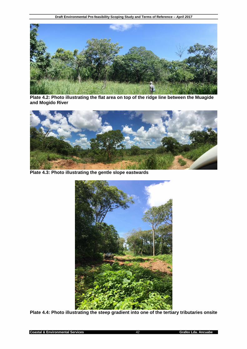
Draft Environmental Pre-feasibility Scoping Study and Terms of Reference – April 2017
Coastal & Environmental Services 42 Grafex Lda. Ancuabe
Plate 4.2: Photo illustrating the flat area on top of the ridge line between the Muagide and Mogido River
Plate 4.3: Photo illustrating the gentle slope eastwards
Plate 4.4: Photo illustrating the steep gradient into one of the tertiary tributaries onsite

Draft Environmental Pre-feasibility Scoping Study and Terms of Reference – April 2017
Coastal & Environmental Services 43 Grafex Lda. Ancuabe
4.1.3. Hydrology The hydrology of the district is dominated by several waterways, almost all of them annual rivers. The mean annual runoff in the region was calculated by Middleton (1992) as approximately 25 million m3/annum, with the majority of the flow occurring in the 6 month period from November to April. The graphite resource lies between the Muagide River to the west and the Mogido River to the east, both rivers drain to Pemba Bay to the East. The Muaguide River flows during the months of November through to April and has an average depth of between 1 and 2m. The river bed varies in width, but is on average 30m wide with 2m high banks. The Muaguide basin has an area of 1811 km² and a river length of 85km. The Ancuabe Graphite Mine Project Area covers 2% of the Muaguide basin and approximately 9.4 km of the Muaguide River (Figure 4-3).
Figure 4-3: Hydrology of the Ancuabe Graphite Project Area
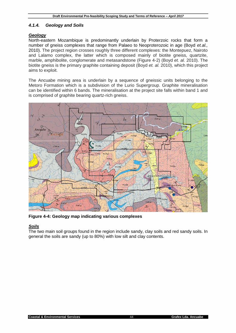
Draft Environmental Pre-feasibility Scoping Study and Terms of Reference – April 2017
Coastal & Environmental Services 44 Grafex Lda. Ancuabe
4.1.4. Geology and Soils Geology North-eastern Mozambique is predominantly underlain by Proterzoic rocks that form a number of gneiss complexes that range from Palaeo to Neoproterozoic in age (Boyd et.al., 2010). The project region crosses roughly three different complexes: the Montepuez, Nairoto and Lalamo complex, the latter which is composed mainly of biotite gneiss, quartzite, marble, amphibolite, conglomerate and metasandstone (Figure 4-2) (Boyd et. al. 2010). The biotite gneiss is the primary graphite containing deposit (Boyd et. al. 2010), which this project aims to exploit. The Ancuabe mining area is underlain by a sequence of gneissic units belonging to the Metoro Formation which is a subdivision of the Lurio Supergroup. Graphite mineralisation can be identified within 6 bands. The mineralisation at the project site falls within band 1 and is comprised of graphite bearing quartz-rich gneiss.
Figure 4-4: Geology map indicating various complexes Soils The two main soil groups found in the region include sandy, clay soils and red sandy soils. In general the soils are sandy (up to 80%) with low silt and clay contents.

Draft Environmental Pre-feasibility Scoping Study and Terms of Reference – April 2017
Coastal & Environmental Services 45 Grafex Lda. Ancuabe
Plate 4.5: Graphite exposed at surface level and drill core samples to test for graphite.
4.1.5. Land use Compared with other countries in the region, Mozambique has a rich natural resource base including untransformed indigenous forests, savannah, woodlands and coastal habitats. About 25% of the land has commercial forestry potential, 12.5% constitutes state-protected areas and a further 22% comprises potential wildlife habitat (GPZ, 2003). There was evidence of agriculture in the western portions of the study area, where extensive clearing for the establishment of machambas, and for producing charcoal, had taken place (Plate 4-4 and 4-5). The vegetation in this area is also secondary in nature, with few large trees remaining, indicating a long history of disturbance. There is evidence of charcoal production through most of the site, and the project area’s natural resources are also used for subsistence purposes (Bicanic et al., 2014). This usually includes collecting wood, thatch and bamboo for construction, but also collecting wild fruits, vegetables and bulbs either for medicinal purposes or for food. Most of the households also make charcoal from felled wood, which many sell next to the road. Mineral extraction is the other major land use within the region, which has been responsible for much of Ancuabe’s economic development of the last few years (Bicanic et al., 2014). Primarily graphite is mined, but to a lesser degree rubies are increasingly being exploited, often through illegal mining operations (Bicanic et al., 2014). Local villagers were seen mining the dry river beds during the last site visit.

Draft Environmental Pre-feasibility Scoping Study and Terms of Reference – April 2017
Coastal & Environmental Services 46 Grafex Lda. Ancuabe
Plate 4.6: Clearing occurring in the west section of the study site for charcoal production and agriculture.
Plate 4.7: Natural resource use within the project area. Charcoal production, bamboo collection, ruby mining within the river bed and wood collection.

Draft Environmental Pre-feasibility Scoping Study and Terms of Reference – April 2017
Coastal & Environmental Services 47 Grafex Lda. Ancuabe
4.2. BIOLOGICAL ENVIRONMENT 4.2.1. Vegetation Seventy-nine percent of Mozambique is covered in natural vegetation. Although several research projects have recently aimed at documenting Mozambique’s diversity, the current conservation status of the country’s flora still remains fairly unknown (Dudley and Stolton, 2012). Despite this, analyses of existing data show that the biodiversity in the country is high (USAID, 2008) and that globally, Mozambique boasts 7 ecological zones of international importance. These include the:
Agulhas Current,
East African Coast,
Lakes of the Rift Valley,
East African Mangroves,
Forests of the South Rift Valley,
East and Central Miombo Woodlands, and the
Savannas of the Zambezi Floodplains. Other sites of high importance for biodiversity include Lake Niassa, Gorongosa Mountain, the Archipelago of Quirimbas, and the Chimanimani Massif (Dudley and Stolton, 2012; USAID, 2008). Despite 16% of the country being declared as protected, these areas still face many challenges such as being understaffed, underfunded and without qualified personnel (USAID, 2008). Consequently, some of these areas are only protected on paper. White (1983) classified the geographic area of Mozambique into 8 vegetation types. The project area falls within Miombo Woodland. Miombo woodland is characterised by having many species of the genus Brachystegia, nineteen in total. The presence of three other species also characterise this vegetation type: Isoberlinia angloensis, Julberbernadia globiflora and Julbernadia paniculata. These are rarely found outside of Miombo Woodland (Frost 1996). Miombo Woodland is usually divided into 2 types: wetter and drier Miombo. The project area falls within drier Miombo which is defined by the following characteristics: (i) Rainfall is less than 1000mm, (ii) canopy height less than 15m, and (iii) dominant species are Julbernardia globiflora, Brachystegia spiciformis and Brachystegia boehmii. Vegetation associated with Miombo Woodland includes dry deciduous forest and thicket, deciduous riparian forest, and dry dambos. Woody plants comprise 95-98% of the above-ground biomass of undisturbed Miombo Woodland stands, with grasses and herbs making up the remainder. The herbaceous layer varies greatly in composition and biomass and includes grasses (mainly of the genera Hyparrhenia, Andropogon, Loudetia, Digitaria and Eragrostis. It also includes suppressed saplings of canopy trees (Frost 1996). Two vegetation types occur within the project area; Miombo Woodland and Riparian Woodland. The Miombo woodland present was tall, intact and ranged from patches of forest with a closed canopy to open Miombo Woodland (Plate 4-5A). Large sections of vegetation in the south-western portion of the study area (along the haul road) has been cleared (April 2017) for agriculture, and hence much of the remaining vegetation in this area appeared secondary in nature. In contrast, there were very few signs of disturbance in the eastern portion of the study area, probably due to the greater distance between the eastern study area and the villages, most of which are located west of the site. The result of this is that the vegetation towards the east is intact and ecologically more sensitive than the vegetation to the west.

Draft Environmental Pre-feasibility Scoping Study and Terms of Reference – April 2017
Coastal & Environmental Services 48 Grafex Lda. Ancuabe
The Riparian woodland is limited to the water courses and is also generally intact and in surprisingly good condition (Plate 4-5B).
Plate 4.8: Miombo Woodland (A) and Riparian Woodland (B) found within the study area. Floristic Diversity Various factors, including a long period of war and internal turmoil, resulted in Mozambique’s floristic diversity going without intensive study, especially in northern Mozambique. Since peace was declared in 1992, studies of specific areas have been undertaken. However, a broad description of Mozambique’s floristic diversity relies on studies undertaken in the eighties or earlier.
B
A

Draft Environmental Pre-feasibility Scoping Study and Terms of Reference – April 2017
Coastal & Environmental Services 49 Grafex Lda. Ancuabe
Surveys have revealed the existence of an estimated 5 500 plant species in Mozambique although the actual number is likely to be much higher (MICOA, 1997 and 2009). One hundred and seventeen (117) of these species are endemic and 300 occur on the Mozambique Red Data List (MICOA, 2002). It is possible that species listed on the Mozambique Red Data List could occur on the project site (Table 4.2). Table 4.2: Species listed on the Mozambique Red Data List that could occur on site
Species Status Endemism Encountered on Site
Adenia mossambicensis Vulnerable Endemic No
Cassipourea obovata Vulnerable Endemic No
Combretum stocksii Vulnerable Endemic No
Dichapetalum zambesianum Vulnerable Endemic No
Grevea eggelingii Vulnerable Near-Endemic No
Hexalobus mossambicensis Vulnerable Possible Endemic No
Homalium mossambicensis Vulnerable Endemic No
Maerua andradae Vulnerable Endemic No
Viscum littoreum Vulnerable Endemic No
4.2.2. Fauna Mozambique has a diverse herpetofauna due to the variety of different habitat types available and the large area of the country. However, the lack of scientific study of northern Mozambique has led to widely disparate and inaccurate summaries for the country’s herpetofaunal diversity. Avifauna in this region is diverse with more than 680 bird species being recorded. Some of these species are commensal, rapidly and successfully adapting to modified environments, although most are sensitive to disturbance and either migrate away from or suffer greater mortality within degraded habitats. However, birds are able to rapidly recolonize rehabilitated areas as a result of their high mobility. Mammalian diversity in Mozambique was last reviewed by Smithers and Tello in 1976 and approximately 238 species reported to occur throughout the country (MICOA 2009, IUCN 2012). Within many areas of the country, localised environmental pressure and subsequent habitat loss and fragmentation has resulted in reduced mammal populations. Large mammals such as elephant, hippopotamus and rhino have been extirpated in many areas and nine of the 21 antelope species in the country are listed as threatened and one has become locally extinct. However, given that the vegetation in the study areas is largely intact and it is in close proximity to the Quirimbas National Park this area is expected to have a high bird, mammalian and herpetofauna (Lizards and frogs). 4.2.3. WWF Eco regions The World Wildlife Fund (WWF) has defined global eco regions based on geographically distinct assemblages of species, natural communities and environmental conditions. Information on each eco region and its conservation status are provided to assist with the continued conservation of these areas. The project area traverses the Central and Eastern Miombo Woodlands Eco region and the Southern Zanzibar-Inhambane Coastal Forest Mosaic as defined by WWF (Figure 4-3).

Draft Environmental Pre-feasibility Scoping Study and Terms of Reference – April 2017
Coastal & Environmental Services 50 Grafex Lda. Ancuabe
The Miombo Woodlands are a widespread eco region covering much of central and southern Africa. They are characterised by ahigh species diversity and dominated by a woody component whose dynamics can be attributed to three interacting disturbances: people, fire and wildlife. Anthropogenic activities such as clearing for agriculture, harvesting and burning have resulted in the modification or transformation of this ecosystem in many areas. Population growth therefore poses a threat to this Eco Region and it has consequently been listed as vulnerable (Figure 4-3). The Southern Zanzibar-Inhambane Coastal Forest Mosaic stretches for approximately 2200 km along the eastern coast of the African continent from southern Tanzania to Xai-Xai in Mozambique (Schipper and Burgess, 2015). This eco-region generally occurs within 50km of the Indian Ocean coastline. There are a few outliers of habitats that resemble this inland in western Mozambique, Malawi and Zimbabwe. This eco region also occurs on small offshore islands in Mozambique such as the Bazaruto Archipelago. The boundaries used by WWF to delineate the eco region are similar to modifications made to the Swahilian-Maputaland Regional transition zone proposed by Clarke (1998). However, the WWF map of the southern boundary follows the delineation proposed by White (1983). The northern boundary of this eco-region was moved north from Clarke’s (1998) boundary in southern Tanzania, as this area represents a possible transition among biotas (WWF, 1998). In Mozambique, this eco-region is threatened by activities such as commercial logging and clearing of vegetation for agriculture (Schipper and Burgess, 2015). However, the severity of these impacts is difficult to predict due to a lack of information on the biota and sites in the vegetation type. Based on the current threats to the eco-region and its high level of endemism (specifically in northern Mozambique and Tanzania) it has been classified as Critically Endangered by WWF. However, it is important to note that these eco-regions are mapped at a course scale and as a consequence can be inaccurate. Therefore it is important that the status of the environment must be verified with field surveys conducted by specialists to determine the actual status of the study area at a finer scale. 4.2.4. Protected Areas All protected areas, including National Parks, Forest Reserves and Trans-frontier Conservation Areas, are the responsibility of MITADER. The Forest Reserves were created to safeguard timber reserves from advancing agriculture for future sustainable utilization. The possibility that these reserves can make a significant contribution towards biodiversity conservation has been recognized and studies are being conducted to gain an understanding of the vegetation and ecosystem condition within these reserves. According to Muller et al. (2005), of the 13 existing forest reserves, five (Licuáti, Derre, Moribane, Mecuburi, and Matibane) are co-managed as commonage between the Forest Service and local communities. Only two of the forest reserves (Inhamitanga and Nhampacue) are not currently inhabited. All the forest reserves (including those under management and the ones uninhabited) show different degrees of human disturbance, particularly clearing for agriculture, human induced fire, collection of firewood and charcoal, and logging. Among the causes of degradation of the forest reserves are abandonment of the forest reserves by the Forest Service during the civil war, use of forest reserves as hideouts by communities and guerrilla fighters, promotion of agriculture within the communities living inside the forest reserves, illegal logging, and poaching among others. Examination of these protected areas in relation to the project site revealed that Quirimbas National Park occurs immediately north of the project site (~12km) and ~ 3 km from the 10km buffer placed around the reserve (Figure 4-4). This reserve was established in 2002 to protect the regions natural resources and covers an area of approximately 750, 639 ha that includes miombo woodland, coastal forest, mangroves and coral reefs (WWF, 2015).

Draft Environmental Pre-feasibility Scoping Study and Terms of Reference – April 2017
Coastal & Environmental Services 51 Grafex Lda. Ancuabe
The Niassa Game Reserve (NGR) lies approximately 175 km from the proposed mining area. The core area of the NGR is located between the Rovuma and Lugenda River and covers approximately 23 040km2 with a surrounding buffer zone of hunting blocks that make up an additional 19 239km2 (Branch et. al., 2005). The NGR is the largest conservation area in Mozambique.
Figure 4-5: WWF Eco Regions and Protected Areas surrounding the project site

Draft Environmental Pre-feasibility Scoping Study and Terms of Reference – April 2017
Coastal & Environmental Services 52 Grafex Lda. Ancuabe
5. DESCRIPTION OF THE SOCIO-ECONOMIC ENVIRONMENT 5.1. INTRODUCTION The project area is approximately 80km by road west of Pemba and is located within the Ancuabe District in the Cabo Delgado Province of Mozambique. The nearest main town to the project area is the town of Ancuabe which is still 20km away. There are several villages located outside the License Area with the nearest 10km away (figure 5.1). This chapter provides an overview of the socio-economic setting in the area within which the proposed project is located.
Figure 5-1: Project area (green block) in relation to nearest villages 5.2. DEMOGRAPHICS AND SOCIAL INFRASTRUCTURE 5.2.1. Cabo Delgado Province
The proposed project is located within the Cabo Delgado province of Mozambique and has a land area of 76 867km2. According to the Regional Statistics of Mozambique (2015), the total population of Cabo Delgado is 1.6 million people (Regional Statistics of Mozambique, 2015; Club of Mozambique, 2007). 52% of the population is female and 48% male. 69% of the population above the age of 5 years old are illiterate. Of the 404 431 households in Cabo Delgado only 5% have running water, 3% have electricity and 0.6% have flushing toilets in their homes.
5.2.2. Ancuabe District
The proposed project is located within the Ancuabe district in the southern portion of the Cabo Delgado province. The Ancuabe District covers an area of approximately 4918 km2
and has an estimated population of 118 926 (24.6ppl/km2) (Regional Statistics of Mozambique, 2015). 52% of the population is female and 48% male. 98% of the population above the age of 5 years old are illiterate. Over and above Portuguese there are six tribal

Draft Environmental Pre-feasibility Scoping Study and Terms of Reference – April 2017
Coastal & Environmental Services 53 Grafex Lda. Ancuabe
languages Emakhuwa the most widely spoken language. Of the 27 593 households in the Ancuabe District only 0.5% have running water, 0.3% have electricity and 0.1% have flushing toilets in their homes.
5.2.3. Ancuabe Town
Ancuabe is the closest town to the project area approximately 10km away. The town of Ancuabe has a population of 40 989 (Knoema, 2015). 70.5% of the population above the age of 5 years old are illiterate. Of the 10,363 households in the town of Ancuabe only 0.25% have running water, 0.36% have electricity and 0.14% have flushing toilets in their homes.
5.2.4. Villages Many of the larger villages such as Nankhumi, Natocua, Maguide and Nacussa have hand pumps for accessing groundwater, although rivers and streams are used for drinking water and washing. Most rural households normally have their own pit latrines with thatch and bamboo coverings, as there is no water borne sanitation systems. With limited energy in the area, most households are reliant on wood or charcoal as their primary source of energy. Occasional forms of electricity observed include generators and solar panels. Most villages in the area have a primary school teaching grades 1-7. However, the literacy rate of the province is low, and based on previous studies it appears that very few household members older than 18 years (often less than 10%) have completed primary school. The closest healthcare facility is situated in either Ancuabe or Pemba. Vector-related diseases, such as malaria, soil- and water-related diseases as well as HIV/AIDs and malnutrition are prevalent in this area. 5.3. EMPLOYMENT SECTORS The unemployment rate is calculated by dividing the number of unemployed individuals by the labour force; the latter includes all members in the working-age group who are available or capable of working. Mozambique relies heavily on the agricultural sector for employment with an estimated 80.5% employed in the sector in 2013 (The World Bank, 2013). In 2012, the unemployment rate in Mozambique was estimated at approximately 27%, with the majority of employed people living in urban areas (Macauhub, 2012). Employment opportunities are limited in the rural villages. Most households in villages proximate to the site are subsistence farmers (some of whom might sell some produce locally), and a few local traders. Within some of the districts, employment in mining and exploration has steadily increased with several mines being developed in the province. The mining sector is expanding in the region and will provide a range of employment opportunities in the future. Cabo Delgado covers 10.3% of land surface of Mozambique and 8.5% of its population, but produces 5.3% of the country’s GDP (Bechtel, 2001). Apart from the agricultural sector, in 2003 the trade, restaurants and hotel sectors employed most of the country’s citizen with an estimated 557 974 persons and with about 398 935 people employed by the financial, real estate and business sectors. 5.4. AGRICULTURE AND LIVELIHOOD STRATEGIES Agriculture is an important sector for the local economy as well as the economy of the country at large. Approximately 70% of the population in Mozambique is located in the rural areas, 75% of which rely on agriculture for its livelihoods. An estimated 95% of residents in Cabo Delgado rely on agriculture (Bechtel, 2001). The households which are in the villages usually have agricultural fields, locally called machambas and some households have small food gardens around their homesteads. The form of agricultural practice in Cabo Delgado is mostly subsistence, and due to the lack of
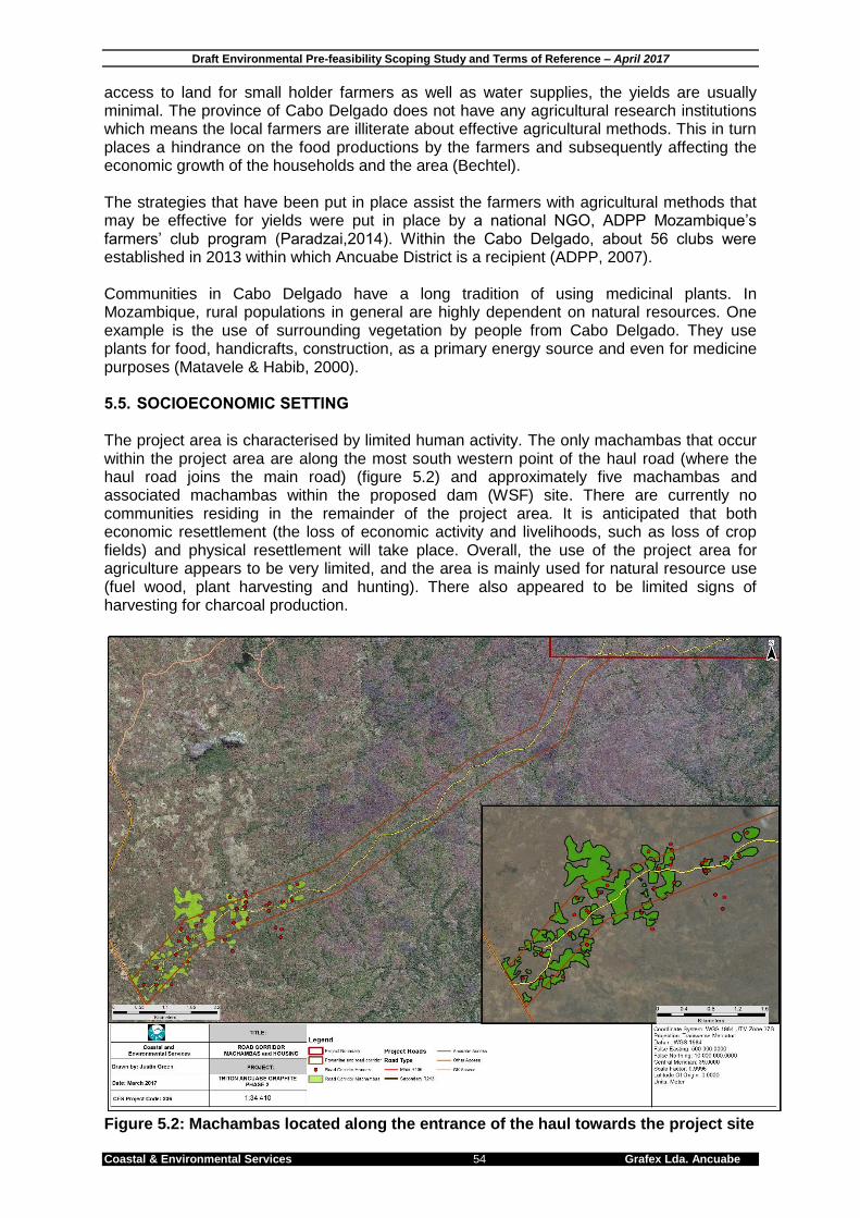
Draft Environmental Pre-feasibility Scoping Study and Terms of Reference – April 2017
Coastal & Environmental Services 54 Grafex Lda. Ancuabe
access to land for small holder farmers as well as water supplies, the yields are usually minimal. The province of Cabo Delgado does not have any agricultural research institutions which means the local farmers are illiterate about effective agricultural methods. This in turn places a hindrance on the food productions by the farmers and subsequently affecting the economic growth of the households and the area (Bechtel). The strategies that have been put in place assist the farmers with agricultural methods that may be effective for yields were put in place by a national NGO, ADPP Mozambique’s farmers’ club program (Paradzai,2014). Within the Cabo Delgado, about 56 clubs were established in 2013 within which Ancuabe District is a recipient (ADPP, 2007). Communities in Cabo Delgado have a long tradition of using medicinal plants. In Mozambique, rural populations in general are highly dependent on natural resources. One example is the use of surrounding vegetation by people from Cabo Delgado. They use plants for food, handicrafts, construction, as a primary energy source and even for medicine purposes (Matavele & Habib, 2000). 5.5. SOCIOECONOMIC SETTING The project area is characterised by limited human activity. The only machambas that occur within the project area are along the most south western point of the haul road (where the haul road joins the main road) (figure 5.2) and approximately five machambas and associated machambas within the proposed dam (WSF) site. There are currently no communities residing in the remainder of the project area. It is anticipated that both economic resettlement (the loss of economic activity and livelihoods, such as loss of crop fields) and physical resettlement will take place. Overall, the use of the project area for agriculture appears to be very limited, and the area is mainly used for natural resource use (fuel wood, plant harvesting and hunting). There also appeared to be limited signs of harvesting for charcoal production.
Figure 5.2: Machambas located along the entrance of the haul towards the project site

Draft Environmental Pre-feasibility Scoping Study and Terms of Reference – April 2017
Coastal & Environmental Services 55 Grafex Lda. Ancuabe
6. STAKEHOLDER AND COMMUNITY ENGAGEMENT PROCESS 6.1. INTRODUCTION Stakeholder engagement involves consultation with the wider public, NGO’s, relevant authorities and local communities. The process facilitates the dissemination of information about the project, and a primary objective is the identification of people who might be indirectly and directly affected by the project. In the EIA process they are referred to as Interested and Affected Parties (I&APs). The stakeholder engagement will be outlined in detail in the Stakeholder Engagement Report (Volume 1B), which will provide details on all the meetings that have been held during the EPDA phase of the ESHIA process. It will be expanded on after the EIR documentation has been released for a 30-day public disclosure period. The final PPP document, with all the relevant minutes of the meetings, together with the final EIA documentation, will be submitted to MITADER for their adjudication. In accordance with the Mozambican EIA Regulation (Decree No. 45/2004 of 29 September as amended by decree No 42/2008 of 24 November), the proposed project has been classified by MITADER as a Category A Project, which includes the implementation of a stakeholder engagement. The stakeholder engagement is crucial for any Category A project. It is vital that all I&APs are not only aware of the project and its possible negative implications, but also understand the project and its potential benefits to their communities and the surrounding environment. Failure to ensure this could cause disputes and disagreements between communities, the developer and government authorities and lead to the disruption of established structures such as community administration. The proponent is required to undertake the stakeholder engagement throughout the ESHIA process. This includes providing sufficient advertising and allowing the opportunity for I&APs to participate in public meetings. The stakeholder engagement undertaken for this EIA will be compliant with MITADER directives and international standards. As part of this process, public consultation meetings are organized where all I&APs are invited and are afforded an opportunity to express and record their concerns, expectations and comments relating to the proposed project and environmental authorization process. 6.2. MOZAMBIQUE LEGISLATION Both the Constitution and Environment Law establish the rights of citizens to have information about, and to participate in, decision-making relating to activities which may affect the environment. MITADER have prepared a General Directive for the Public Participation Process in the EIA process, published as Ministerial Diploma 130/2006 of 19 July. The need for public participation is further reinforced by the new Regulations on Resettlement Process resulting from Economic Activities as per Decree 31/2012, of 8 August. Article 13 of this Regulation points out the need to ensure public participation throughout the entire process of development and implementation of Resettlement Action Plan for projects. The stakeholder engagement phase of the ESHIA is expected to:
Identify the stakeholders, Disseminate information to stakeholders Manage a dialogue with the proponent of the activity, Assimilate and take into account public comments received and Provide feedback in response to the outcomes of the dialogue and inputs so as to demonstrate
how these have been taken into account in the design of the activity. The stakeholder engagement process is divided into two phases, the first is for the presentation of the draft EPDA and the second is for the presentation of the draft ESHIA. The proponent must disclose it to the public for a 30 day period in order to comply with international standards.

Draft Environmental Pre-feasibility Scoping Study and Terms of Reference – April 2017
EOH Coastal & Environmental Services 56 Grafex Lda. Ancuabe
6.3. IFC REGULATIONS AND REQUIREMENTS FOR STAKEHOLDER ENGAGEMENT Grafex have committed to this EIA being undertaken to international standards. The International Finance Corporation’s (IFC) Performance Standards 1 to 8 are used as the benchmark to determine best practice in EIA, and to ensure compliance with the Equator Principles. The engagement process undertaken in accordance with General Directive for the Public Participation Process in the EIA process is, in general terms, fully compliant with international standards. The engagement process must include consultation with all parties that may be affected by a project, including local communities, organisations (such as Non-Governmental Organisations (NGOs) and Non-Profit Organisation (NPOs)), local, provincial and national authorities, and other interested parties. The consultation focuses on relevant social and environmental risks and impacts, and the proposed measures and actions to address these. In essence the stakeholder engagement must ensure free, prior and informed consultation with stakeholders (IFC, 2007). The nature and frequency of community engagement is a reflection of the project’s risks to, and adverse impacts on, the affected communities. To meet international standards community engagement must be free of external manipulation, interference, coercion and intimidation, and be conducted on the basis of timely, relevant, understandable and accessible information. The IFC states that the minimum for community engagement during an ESHIA is two rounds, one at the scoping phase and one to provide feedback on the results of the ESHIA once all specialist studies have been completed. 6.4. PUBLIC PARTICIPATION ACTIVITIES The first phase involved meetings with local communities and local authorities, as well as meetings in Pemba and Maputo to meet with provincial and national stakeholders, in order to introduce the project. The second phase of the stakeholder engagement will involve the same I&APs as the initial engagement, and will be undertaken to disclose the draft EPDA. The third phase will involve disclosure of draft EIA documentation. 6.4.1. EPDA Stakeholder Engagement Process The second phase will consist of open public meetings with local communities and in the cities of Ancuabe and Pemba. It will be conducted in five distinct stages:
1. Preparation of the list of stakeholders; 2. Preliminary consultations with communities and government institutions and non-governmental
organizations; 3. Submission of project documents (Pre-Feasibility Studies and Environmental Scoping - EPDA) to
the relevant institutions. These documents will be available for consultation before the public meetings.
4. Preparation and delivery of invitation letters to relevant stakeholders 5. Realisation of public consultation meetings in the affected communities in Ancuabe and Pemba
and Maputo. The main objective of the phase II stakeholder engagement is to present the findings of the EPDA, which presents the findings of the preliminary assessment of the project, the initial risk assessment, the outcome of the phase I stakeholder engagement, and details on the specialist studies that will be required to deal with issues and concerns that have been raised.
Draft Environmental Pre-feasibility Scoping Study and Terms of Reference – April 2017
Coastal & Environmental Services 57 Grafex Lda. Ancuabe
7. PRELIMINARY ENVIRONMENTAL AND SOCIAL RISK ASSESSMENT 7.1. RISK ASSESSMENT METHODOLOGY The approach to the pre-feasibility assessment is based on recent sustainability appraisals and risk assessments that have been conducted by CES. The first step is to identify and assess the ecological and social significance of key issues, and then consider the potential to mitigate each, with the degree of difficulty interpreted in terms of effectiveness, practicality and cost effectiveness. For this reason, CES uses both an Impact Assessment and a Risk Assessment scale to identify significant environmental impacts and project related risks. Thereafter a risk matrix is applied to arrive at a final risk rating. The methodology that was used for assessing these impacts and risks is described fully below. The environmental significance scale evaluates the importance of a particular impact. This evaluation needs to be undertaken in the relevant context, as an impact can either be ecological or social, or both. The evaluation of the significance of an impact relies heavily on the values of the person making the judgement. For this reason, impacts of especially a social nature need to reflect the values of the affected society. A four-point impact significance scale was applied (Table 7.1). Table 7.1: Environmental significance rating scale
Significance rating
Description
Very High These impacts would constitute a major and usually permanent change to the (natural and/or social) environment, and usually result in severe or very severe effects, or beneficial or very beneficial effects.
High
These impacts will usually result in long term effects on the social and/or natural environment. Impacts rated as high will need to be considered by the project decision makers as constituting an important and usually long term change to the (natural and/or social) environment. These would have to be viewed in a serious light.
Moderate
These impacts will usually result in medium to long term effects on the social and/or natural environment. Impacts rated as moderate will need to be considered by the project decision makers as constituting a fairly important and usually medium term change to the (natural and/or social) environment. These impacts are real but not substantial.
Low
These impacts will usually result in medium to short term effects on the social and/or natural environment. Impacts rated as low are generally fairly unimportant and usually constitute a short term change to the (natural and/or social) environment. These impacts are not substantial and are likely to have little real effect.
The degree of difficulty of mitigating the various impacts ranges from very difficult to easily achievable. The four categories used are listed and explained in Table 7.2 below. The practical feasibility of the measures, financial feasibility of the measures and their potential effectiveness was taken into consideration in deciding on the appropriate degree of difficulty. Table 7.2: Degree of mitigation difficulty rating scale
Degree of Difficulty Description
Very difficult The impact could be mitigated but it would be very difficult to ensure effectiveness and/or to technically/financially achieve
Difficult The impact could be mitigated but there will be some difficulty in ensuring effectiveness and/or implementation
Achievable The impact can be effectively mitigated without much difficulty or cost
Easily achievable The impact can be easily and effectively mitigated

Draft Environmental Pre-feasibility Scoping Study and Terms of Reference – April 2017
EOH Coastal & Environmental Services 58 Grafex Lda. Ancuabe
The risk matrix determines the overall level of risk associated with an impact by comparing the significance of the impact with its difficulty of mitigation is shown in Table 7.3 below. Table 7.3: Risk matrix derived from the pairing of the significance of the impact and the difficulty of mitigation
Mitigation Potential
Impact Significance Low Moderate High Very High
Very difficult Medium Risk Major Risk Extreme Risk Extreme Risk Difficult Minor Risk Medium Risk Major Risk Extreme Risk Achievable Minor Risk Minor Risk Medium Risk Major Risk Easily achievable Minor Risk Minor Risk Minor Risk Medium Risk
Impacts that are of high to very high significance and difficult to very difficult to mitigate are considered to be ‘extreme’ environmental or social risks to the project. Those impacts that are less significant and easier to mitigate are rated as ‘major’ to ‘medium’ to ‘minor’ i.e. generally impacts of low to moderate significance for which mitigation is achievable to easily achievable. Impacts may potentially be of very high significance, but if the mitigation is easily achievable they are rated as ‘medium’ risks, as per Table 7.3. The implications of the risk categories are explained in Table 7.4. Table 7.4: Risk categories
Risk Description
Extreme
Significant mitigatory actions would be required to reduce these risks. In some cases it may not be possible to reduce these extreme risks meaning they are likely to prevent the option from being used (raised as red flags in this assessment).
Major
These risks are of a serious nature, and without effective mitigation measures would be major hindrances to the project. These would need to be monitored and managed, and in combination Major risks may necessitate the use of a different option to achieve the projects objectives.
Medium
These risks are of a less serious nature but still important, and need to be reduced to As Low As Reasonably Possible (ALARP) for the benefit of the environment or social network affected. In isolation these risks are generally insufficient to prevent the project from proceeding.
Minor
These risks are generally acceptable to the project and environment, and mitigation is desirable but not essential. Best practice, however, should be followed and the risks mitigated to prevent a cumulative effect of such impacts.
The risks associated with the project are discussed in accordance with the requirements of the IFC’s Performance Standards 1 to 8, (excluding 7, which is not applicable) below. 7.2. KEY BIOLOGICAL IMPACTS AND RISKS
The impacts and risks presented below have been assessed in line with the Ecological and Planning Performance Standards of the International Finance Corporation.
Performance Standard 6: Biodiversity Conservation & Sustainable Natural Resource Management
Performance Standard 3: Pollution Prevention and Abatement The area in which the Ancuabe Graphite mine has been proposed is considered to be a natural and un-modified ecosystem with the nearest community and main road approximately 10km away. A total of fourteen biological risks were identified, four of which are considered to be of Major risk on the biological environment. These are presented in further detail below in Table 7.5.

Draft Environmental Pre-feasibility Scoping Study and Terms of Reference – April 2017
Coastal & Environmental Services 59 Grafex Lda. Ancuabe
Table 7.5: Summary of biological risks PERFORMANCE STANDARD 6: BIODIVERSITY CONSERVATION AND SUSTAINABLE NATURAL RESOURCE MANAGEMENT
Themes: (i) Impacts on biodiversity (habitat, modified habitat, natural habitat, critical habitat, legally protected areas, invasive alien species); (ii) Management and use of natural resources (natural and plantation forests, freshwater and marine systems); (iii) management.
Issue Significance
Rating Comment
Mitigation Potential
Risk
Loss of biodiversity (fauna and flora)
High
The mining process results in vegetation being cleared in the mine pit area, and adjacent areas are cleared for infrastructure. This results in a loss of vegetation, reduced biodiversity (fauna and flora) and the possible loss of some species of special concern (SSC). The rehabilitation of indigenous vegetation on some areas affected by mining is possible, such as the TSF, but generally mitigation through rehabilitation of the areas directly disturbed by the mining operation would be difficult to achieve. For example, rehabilitation of the waste rock dumps and pits will not restore biodiversity. This is an impact of high significant and therefore a major risk.
Difficult MAJOR
Habitat fragmentation and loss of fauna and flora species
High
Fragmentation of habitats can lead to the loss of viable populations, especially in animals requiring large home ranges. Fragmentation has serious impacts on forest/woodland specialists and wetlands. This area is considered to be in a natural state with little to no habitat fragmentation, and is mostly covered by woodland. The area is considered difficult to access and no agriculture is practiced on the project site; and natural resource collection is minimal, allowing for the woodland to remain intact. Mining will result in the fragmentation of an established ecosystem causing a break in floral communities and faunal habitats. This is therefore regarded as being of high significance. Mitigation through rehabilitation of the disturbed landscape would be difficult to achieve, and large structures such as the mine pits and TSF will be permanent features on the altered landscape. For the reasons mentioned above this issue is considered a major risk.
Difficult MAJOR
Disturbance to drainage lines and wetlands
High
Any water course/drainage line and wetland impacted by mining activities is likely to have a permanent and irreversible impact on pre-existing hydrological function. Landform rehabilitation that replicates the basic function successfully is difficult to achieve, and the raw water dam will permanently alter the river. The issue is therefore regarded as being of a high significance and therefore a major risk.
Difficult MAJOR
Change to catchment dynamics
High
The in channel water storage dam has been proposed for the upper reaches of the Muaguide River, The Muaguide river is a primary river and the introduction of a infrastructure of this size will permanently alter the flow dynamics of the river, remove large areas of land and riparian vegetation. This is regarded as being of high biological significance. Mitigation would be difficult to achieve, an ecological reserve will need to be determined thus an Environmental Flow Requirement study of the Muaguide River is required. The Muaguide River is suspected to carry a high sediment load the dam is thus likely to experience high siltation levels which is difficult to mitigate. For the reasons mentioned above this issue is considered a major risk.
Difficult MAJOR
Biodiversity issues associated with tailings management
Moderate
Mining activities may affect local groundwater quality due to contaminated effluent and contamination through contact with wastes. The ore may contain sulphide that unless recovered this may end up in the tailings stream and could generate acid mine drainage, thus polluting the groundwater. A geochemical survey is recommended to determine whether this is likely. In addition to designing and locating the tailings storage facility so as to minimise contaminated water from percolating into the groundwater, it is tentatively proposed that the tailings storage facility is lined. It is important to point out that a geochemical analysis has not been undertaken, and this risk assessment is therefore based on a worst case scenario. The contamination of groundwater, should it occur, will cause in concomitant negative impacts on the biodiversity in the affected area and is therefore an impact of high significance. Mitigation is, however, achievable, resulting in a medium risk.
Achievable MINOR
Impacts of mining on soil productivity
Low
The mining process impacts on the physical and chemical properties of the soil because the soil profile is disturbed during mining. Productivity of top soil is also reduced due to stockpiling, and soil disturbance and handling can result in changes to the cation exchange capacity, the water holding capacity and the erodibility of the soils. These changes to soil fertility also impact on crop productivity and agricultural potential of the land. This impact is of low significance since no cropping currently takes place in the area, but is difficult to mitigate, making this a minor risk.
Difficult MINOR
Loss of Ecosystem Services
Low The clearing of natural vegetation for the pit, and the placement of infrastructure will result in the loss of available ecosystem services such as construction materials, firewood, medicinal plants and food plants to the project affected communities. The impact has many cumulative impacts and is considered difficult to mitigate even with the careful
Difficult MINOR

Draft Environmental Pre-feasibility Scoping Study and Terms of Reference – April 2017
EOH Coastal & Environmental Services 60 Grafex Lda. Ancuabe
management of the facility and provision of alternatives to the resources that are impacted. However, since natural resource use is very limited in the study area, the impact is regarded as low, and this risk is minor.
PERFORMANCE STANDARD III: POLLUTION PREVENTION AND ABATEMENT
Issue Significance
Rating Comment
Mitigation Potential
Risk
Hazardous waste
Moderate
Mining activities may cause the spillages of hazardous materials, which will be limited if best practices are enforced. Sewage will need to be treated and disposed of correctly to avoid impacts on ground and surface water resources. The impact of hazardous waste is considered high. This issue is therefore considered a minor risk.
Achievable MINOR
General solid waste
Moderate
The mining operations will generate general wastes (food, glass, paper, wood, metal, oils and lubricants) which will need to be disposed appropriately in designated waste sites. The impact of improper solid and liquid waste disposal is considered moderate. The implementation of a solid waste management plan as a mitigation measure is achievable. This issue is therefore considered a minor risk for general waste. A collection and approved disposal system should be in place. The ESIA must include the preparation of an Integrated Waste Management Plan compliant with Mozambique legislation. An engineered and lined landfill site for solid waste disposal must be included in the projects design. The principles of reuse, recycle and reduce must be implemented.
Easily Achievable
MINOR
Surface water and stormwater contamination
Moderate
Surface and stormwater can become contaminated through contact with pollutants associated with mining activities such as oils and grease from workshops, hydrocarbons from leaking trucks and pumps, and runoff from refuelling areas for example. Surface water must be protected from coming into contact with any pollutants and any stormwater runoff that passes through potentially contaminated areas must be captured and treated appropriately prior to release. Erosion and sedimentation must be avoided. This is considered an impact of moderate significance as there are no local people reliant on surface water resources in the immediate area. However, there are surface water bodies close to the deposit areas. This is therefore regarded as a minor risk.
Achievable MINOR
Groundwater quality
High
Mining activities may affect local groundwater quality due to contaminated effluent and contamination through contact with wastes (TSF etc.). Contamination of groundwater is considered likely due to the nature of the material being mined and the potential for AMD generation is considered relatively high in the absence of any real data, as a precautionary approach. Further work and proper management of waste streams could reduce this risk to minor. Mitigation is achievable and at this stage we regard this as a medium risk.
Achievable MEDIUM
Noise Low
The mining operation will cause an increase in ambient noise levels in the surrounding areas. There are no residents living adjacent to or even close to the project area, and noise is likely to be an impact of low significance that can be mitigated by using standard industry practice to reduce noise levels. This mitigation is considered achievable and thus this is a minor risk
Achievable MINOR
Air quality Moderate
Dust generation could potentially impact on the natural environment and worker health due to elevated concentrations of inhalable dust (PM10), along roads, cleared areas and conveyors, crushers and transfer areas. The impact of elevated levels of dust could result in an impact of moderate significance. In addition, dust could be generated once the tailings have dried out, since then they are susceptible to wind-blown dispersal. Mitigation is achievable and therefore this is a minor risk.
Achievable MINOR
Energy use Moderate
The mining operation is likely to require significant power which could have a moderate impact on national energy supplies. This can be mitigated by using remote sensing and ground based technology to minimise exploratory digging and drilling and by correctly sizing motors and pumps used in the ore moving process where ever possible (IFC 2007). These mitigations are considered easily achievable therefore this is considered a minor risk.
Easily Achievable
MINOR
Greenhouse Gas Emissions
Moderate
According to the IFC‘s Performance Standard 3 (2012), the production of more than 25 000 tonnes of CO2-equivalents annually by a development should be regarded as significant. According to the IFC‘s Performance Standard 3 (IFC 2012), ―project-induced changes in soil carbon content or above ground biomass, and project –induced decay of organic matter may contribute to direct emissions sources and shall be included in this emissions quantification where such emissions are expected to be significant. It is recommended that a comprehensive carbon footprint be established for the facility within the first year of operation which takes into consideration the loss of vegetation. If this confirms that annual CO2 emissions are likely to exceed the abovementioned threshold, the proponent will develop a greenhouse gas management plan for the operation with the specific intention of reducing GHG emissions as far as practicable. This is considered a minor risk.
Achievable MINOR

Draft Environmental Pre-feasibility Scoping Study and Terms of Reference – April 2017
Coastal & Environmental Services 61 Grafex Lda. Ancuabe
7.3. KEY SOCIAL AND PLANNING IMPACTS AND RISKS
The impacts and risks presented below have been assessed in line with the Social and Planning Performance Standards of the International Finance Corporation.
Performance Standard 1: Social & Environmental Assessment and Management Systems
Performance Standard 2: Labour and Working Conditions
Performance Standard 4: Community Health, Safety and Security
Performance Standard 5: Land Acquisition and Involuntary Resettlement
Performance Standard 8: Cultural Heritage Performance Standard 7: Indigenous Peoples was not included as there are no indigenous people in the area, as defined by the IFC Guidance Notes for PS 7. The area in which the Ancuabe Graphite mine has been proposed has approximately five households and machambas within the proposed dam (WSF) site, approximately 10 machambes are along the most south western point of the haul road (where the haul road joins the main road) and there are no communities residing in the remainder of project area or the near surrounds. The project is located approximately 15km inland of the nearest main road and the closest village is over 10 kilometers away. A total of eleven social risks were identified, one of which is considered to be of Major risk on the social environment. These are presented in further detail below in Table 7.6.
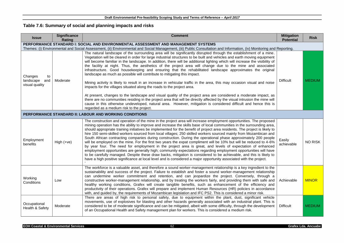
Draft Environmental Pre-feasibility Scoping Study and Terms of Reference – April 2017
EOH Coastal & Environmental Services 62 Grafex Lda. Ancuabe
Table 7.6: Summary of social and planning impacts and risks
Issue Significance
Rating Comment Mitigation
Potential Risk
PERFORMANCE STANDARD I: SOCIAL AND ENVIRONMENTAL ASSESSMENT AND MANAGEMENT SYSTEMS
Themes: (i) Environmental and Social Assessment, (ii) Environmental and Social Management, (iii) Public Consultation and Information, (iv) Monitoring and Reporting.
Changes to landscape and visual quality
Moderate
The natural landscape of the surrounding area will be significantly disrupted through the establishment of a mine. Vegetation will be cleared in order for large industrial structures to be built and vehicles and earth moving equipment will become familiar in the landscape. In addition, there will be additional lighting which will increase the visibility of the facility at night. Thus, the aesthetics of the project area will change due to the mine and associated infrastructure. Good housekeeping and ensuring that the rehabilitated landscape approximates the original landscape as much as possible will contribute to mitigating this impact. Mining activity is likely to result in an increase in vehicular traffic in the area, this may occasion visual and noise impacts for the villages situated along the roads to the project area. At present, changes to the landscape and visual quality of the project area are considered a moderate impact, as there are no communities residing in the project area that will be directly affected by the visual intrusion the mine will cause in this otherwise undeveloped, natural area. However, mitigation is considered difficult and hence this is regarded as a medium risk to the project.
Difficult MEDIUM
PERFORMANCE STANDARD II: LABOUR AND WORKING CONDITIONS
Employment benefits
High (+ve)
The construction and operation of the mine in the project area will increase employment opportunities. The proposed mining operation has the ability to improve and increase the skills base of local communities in the surrounding area, should appropriate training initiatives be implemented for the benefit of project area residents. The project is likely to hire 150 semi-skilled workers sourced from local villages; 250 skilled workers sourced mainly from Mozambican and South African contracting companies during construction. During the operational phase approximately 200 people will be employed on the mine. For the first two years the expat compliment will be 10% but will be reduced to 4-6% by year four. The need for employment in the project area is great, and levels of expectation of enhanced employment opportunities are generally high; community expectations regarding employment opportunities will have to be carefully managed. Despite these draw backs, mitigation is considered to be achievable, and this is likely to have a high positive significance at local level and is considered a major opportunity associated with the project. ‘
Easily achievable
NO RISK
Working Conditions
Low
The workforce is a valuable asset, and therefore a sound worker-management relationship is a key ingredient to the sustainability and success of the project. Failure to establish and foster a sound worker-management relationship can undermine worker commitment and retention, and can jeopardize the project. Conversely, through a constructive worker-management relationship, and by treating the workers fairly, and providing them with safe and healthy working conditions, Grafex will create tangible benefits, such as enhancement of the efficiency and productivity of their operations. Grafex will prepare and implement Human Resources (HR) policies in accordance with, and guided by, the requirements of Mozambican legislation and IFC PS2. This is considered a minor risk.
Achievable MINOR
Occupational Health & Safety
Moderate
There are areas of high risk to personal safety, due to equipment within the plant, dust, significant vehicle movements, use of explosives for blasting and other hazards generally associated with an industrial plant. This is considered to be of moderate significance and can be mitigated, albeit with some difficulty, through the development of an Occupational Health and Safety management plan for workers. This is considered a medium risk.
Difficult MEDIUM
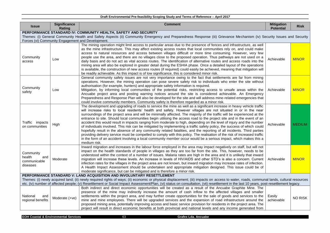
Draft Environmental Pre-feasibility Scoping Study and Terms of Reference – April 2017
EOH Coastal & Environmental Services 63 Grafex Lda. Ancuabe
Issue Significance
Rating Comment Mitigation
Potential Risk
PERFORMANCE STANDARD IV: COMMUNITY HEALTH, SAFETY AND SECURITY
Themes: (i) General Community Health and Safety Aspects (ii) Community Emergency and Preparedness Response (iii) Grievance Mechanism (iv) Security Issues and Security Forces (vi) Community Engagement and Development.
Community access
Low
The mining operation might limit access to particular areas due to the presence of fences and infrastructure, as well as the mine infrastructure. This may affect existing access routes that local communities rely on, and could make access to natural resources and access between villages difficult or more time consuming. However, very few people use the area, and there are no villages close to the proposed operation. Thus pathways are not used on a daily basis and do not act as vital access routes. The identification of alternative routes and access roads into the mining area will also be explored in greater detail during the ESHIA phase. Once a detailed layout of the operations is available, the construction of new access routes (if required) could easily be achieved, meaning that mitigation will be readily achievable. As this impact is of low significance, this is considered minor risk.
Achievable MINOR
Community safety
Low
General community safety issues are not very importance owing to the fact that settlements are far from mining operations. However, the mining operation can pose severe safety risk to individuals who enter the site without authorisation (for example, hunters) and appropriate safety information is required. Mitigation, by informing local communities of the potential risks, restricting access to unsafe areas within the Ancuabe project area and posting warning notices around the site is considered achievable. An Emergency Preparedness and Response Plan will also be developed for the site and will address mine-related emergencies that could involve community members. Community safety is therefore regarded as a minor risk.
Achievable MINOR
Traffic impacts on communities
High
The development and upgrading of roads to service the mine as well as a significant increase in heavy vehicle traffic will increase risks to local residents’ health and safety. However villages are not situated in or in the near surroundings of the project area and will be minimally affected. The majority of the traffic will be experienced at the entrance to site. Should local communities begin utilising the access road to the project site and in the event of an accident this would result in impacts ranging from moderate to high, depending on the level of injury and the number of individuals involved. This risk can be mitigated by implementing a traffic safety policy, the success of which could hopefully result in the absence of any community related fatalities, and the reporting of all incidents. Third parties providing delivery service must be compelled to comply with this policy. The realisation of the risk of increased traffic in the form of an accident involving a local community member occur would be a serious impact, which makes this a medium risk.
Achievable MEDIUM
Community health and communicable diseases
Moderate
Inward migration and increases in the labour force employed in the area may impact negatively on staff, but will not impact on the health standards of people in villages as they are too far from the site. This, however, needs to be understood within the context of a number of issues. Malaria rates are high in the area and it is unlikely that inward migration will increase these levels. An increase in levels of HIV/AIDS and other STD’s is also a concern. Current infection rates for the villages in the project area are not known, but inward migration may increase rates of infection. A Health Impact Assessment should be undertaken and appropriate mitigation designed. This issue could be of moderate significance, but can be mitigated and is therefore a minor risk.
Achievable MINOR
PERFORMANCE STANDARD V: LAND ACQUISITION AND INVOLUNTARY RESETTLEMENT
Themes: (i) newly acquired land; (ii) newly required rights of ways; (ii) economic or physical displacement; (iii) impacts on access to water, roads, communal lands, cultural resources etc. (iv) number of affected people; (v) Resettlement or Social Impact Assessment/Plan, (vi) status on consultation, (vii) resettlement in the last 10 years, post-resettlement legacy.
National and regional benefits
Moderate (+ve)
Both indirect and direct economic opportunities will be created as a result of the Ancuabe Graphite Mine. The presence of the mine may indirectly increase the amount of cash inflow to the affected villages and smaller settlements within the project area, and may further create opportunities for the sale of goods and services to the mine and mine employees. There will be upgraded services and the expansion of road infrastructure around the proposed mining area, potentially improving access and basic service provision for residents in the project area. The project will result in direct economic benefits at both provincial and national levels and any income generated from
Easily achievable
NO RISK
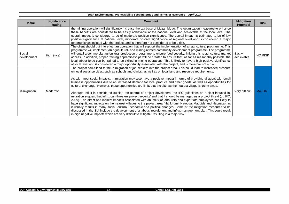
Draft Environmental Pre-feasibility Scoping Study and Terms of Reference – April 2017
EOH Coastal & Environmental Services 64 Grafex Lda. Ancuabe
Issue Significance
Rating Comment Mitigation
Potential Risk
the mining operation will significantly increase the tax base of Mozambique. The optimisation measures to enhance these benefits are considered to be easily achievable at the national level and achievable at the local level. The overall impact is considered to be of moderate positive significance. The overall impact is estimated to be of low positive significance at national level, moderate positive significance at regional level and is considered a major opportunity associated with the project, and is therefore not considered to be a risk.
Social development
High (+ve)
The client should put into effect an operation that will support the implementation of an agricultural programme. This programme will implement an agricultural- and mining-related community development programme. The programme will entail a commercial agricultural production programme to ensure food security, linking this to agricultural market access. In addition, proper training apprenticeships will be created to ensure that, as far as reasonably possible, the local labour force can be trained to be skilled in mining operations. This is likely to have a high positive significance at local level and is considered a major opportunity associated with the project, and is therefore not a risk.
Easily achievable
NO RISK
In-migration Moderate
The project could lead to the in-migration of job seekers into the project area. This could lead to increased pressure on local social services, such as schools and clinics, as well as on local land and resource requirements. As with most social impacts, in-migration may also have a positive impact in terms of providing villagers with small business opportunities due to an increased demand for local produce and other goods, as well as opportunities for cultural exchange. However, these opportunities are limited at the site, as the nearest village is 10km away. Although influx is considered outside the control of project developers, the IFC guidelines on project-induced in-migration suggest that influx can threaten ‘project security’ and that it should be managed as a project threat (cf. IFC, 2009). The direct and indirect impacts associated with an influx of labourers and expatriate employees are likely to have significant impacts on the nearest villages to the project area (Nankhumi, Natocua, Maguide and Nacussa), as it usually results in many social, cultural, economic and political changes. Some of the mitigation measures to be discussed in the SIA include the development of a labour, recruitment and influx management plan. This could result in high negative impacts which are very difficult to mitigate, resulting in a major risk.
Very difficult MAJOR

Draft Environmental Pre-feasibility Scoping Study and Terms of Reference – April 2017
Coastal & Environmental Services 65 Grafex Lda. Ancuabe
8. TERMS OF REFERENCE FOR SPECIALIST STUDIES
8.1. INTRODUCTION This chapter defines the terms of reference for all the specialist studies for the Ancuabe ESHIA in response to the risks identified in the previous chapter. The following specialist studies will be undertaken:
1. Vegetation Assessment 2. Terrestrial Fauna Assessment 3. Fish Assessment 4. Land, Natural Resource Use and Agriculture Assessment 5. Ground Water and Geochemical Assessment 6. Surface Water and Aquatic Assessment 7. Environmental Flow Requirement study of the Muaguide River 8. Socio-economic Impact Assessment 9. Scoping level Health Impact Assessment 10. Waste Management Assessment 11. Traffic, Transport and Visual Assessment 12. Air Quality Assessment 13. Blast Impact Assessment 14. Closure and Rehabilitation Study 15. Resettlement Action Plan
The following studies include sampling in both the wet and dry season surveys:
Vegetation Assessment
Terrestrial Fauna Assessment
Surface Water and Aquatic Assessment
Fish Assessment The remaining studies did not require two sampling periods. The baseline studies will need to satisfy the rigorous IFC Performance Standard requirements. In addition all studies include the following Terms of Reference:
1. Address all issues and concerns raised by IAPs during the scoping phase 2. Identify and assess the significance of the impacts of the construction and operation and
closure of the mine. 3. Provide practical and realistic recommendations to mitigate impacts. 4. Work in consultation with other specialists to ensure that the linkages between the various
systems are understood. The following sections define the specific tasks that will be undertaken to assess the potential impacts the project would have within the particular field of expertise. It is the responsibility of the specialist to determine the best approach, methodologies, and analysis to ensure that all issues are adequately covered and assessed. In all cases specialists must:
Assess the environmental significance of these impacts using the methodology prescribed by CES, as this methodology is compliant with international best practice.
Ensure that the study deals with all issues that were raised as by I&APs during the scoping phase.

Draft Environmental Pre-feasibility Scoping Study and Terms of Reference – April 2017
Coastal & Environmental Services 66 Grafex Lda. Ancuabe
8.2. SPECIALIST TEAM Ms Alice Massingue - Botanical Specialist Alice is PhD candidate in Botany at Environmental Science School, at Nelson Mandela Metropolitan University in South Africa, she holds an MSc in Agriculture Development focused on Forest and Faunas’ Management from Eduardo Mondlane University in Mozambique. She has a graduation degree in Biological Sciences also from Eduardo Mondlane University in Mozambique. Alice has gained considerable experience in implementation of environmental management plans in flora and vegetation such as: Data basing type specimens for JSTOR PLANTS. She has collaborated in various biodiversity of studies, such as Gorongosa Vegetation and Flora survey in Central Mozambique 2006-2007, Coastal Forest Vegetation and Flora survey in Cabo –Delgado 2009-2015, North of Mozambique. Research on threatened plants: collaborated in assessment of threatened plants in Mozambique, in coordination with SANBI, Pretoria South Africa. She has a broad academic background including impact assessments, characterisation of vegetation and flora for environmental licence in Mozambique. Dr Anton Bok - Lead Fresh Water Fish Specialist The author, Dr. Anton Bok, has a PhD in ichthyology from Rhodes University (JLB Smith Institute of Ichthyology, now South African Institute for Aquatic Biodiversity or SAIAB) in South Africa and has over 35 years of experience in the field of fish distribution, conservation and aquatic ecology in Southern Africa. After 20 years of employment as a specialist aquatic scientist in the provincial nature conservation department of the Cape Province and the Eastern Cape Province tasked with freshwater fish conservation, the author entered the private environmental consultancy field in 1997. The author has conducted aquatic ecological surveys and impact assessments as a fish specialist contributing to environmental impact assessments (EIAs) for large projects such as mining ventures and dam building projects in the Eastern Cape as well as throughout South Africa, Democratic Republic of Congo, Zambia, Madagascar, Lesotho and Mozambique. Ms Belinda Huddy – Social Belinda holds an MPhil in Environmental, Society and Sustainability and a Bachelor of Business Science (Hons) in Economics, both obtained from the University of Cape Town. Her master's dissertation explored alternative values attached to the Cape Town Talent Exchange. Her honours thesis investigated the determinants of the success and failures of the bio-diesel industry, focusing on a jatrohpa plantation in Zambia. Courses in her master's degree include Theory and Practice of Environment Management, Managing Complex Human-Ecological Systems, Environmental Law and Cultural Geography. The relevant courses in her honours degree included Environmental Economics and Natural Resource Economics. Mr Bill Rowlston – Environmental Flow Requirement study Bill holds a First Class Honours degree in civil engineering from the University of Salford, England (1971), after which he worked for 11 years for engineering consultants in England.
He then worked for 25 years for the South African Department of Water Affairs and Forestry, where he contributed to the development of the National Water Policy and the National Water Act, and compiled and edited the National Water Resource Strategy, First Edition (2004), much of which he wrote.
Bill joined CES as a Director in 2007. He has worked as project manager on a number of large ESIAs and ESHIAs in South Africa and in other African countries, and has undertaken environmental and social due diligence studies, compliance reviews and audits to international standards for a range of proposed and operational projects.
specialistHe has also prepared specialist reports on water resources, and has compiled traffic impact assessments for industrial, agri-industrial and mining projects, including a manganese smelter and an agri-industrial development in South Africa’s Eastern Cape Province, an iron ore mine in Mozambique, forestry and agri-industrial projects in Mozambique, and a bulk water main in Kwa-Zulu Natal, South Africa.
Draft Environmental Pre-feasibility Scoping Study and Terms of Reference – April 2017
Coastal & Environmental Services 67 Grafex Lda. Ancuabe
Ms Carina Saranga – Local Social consultant Ms Carina Saranga is a Social Consultant at EOH CES since 2013. She is based in the company’s office in Mozambique and speaks English fluently as her second language. She holds a B.Sc. Degree in Law with majors in Public Law (2012), obtained at St. Tomas University in Mozambique. She did her B.Sc. Honours thesis studying the ‘Complexity of the Resettlement Process in Mozambique’. Being familiar with the resettlement and socio-economic context in Mozambique through her studies, Ms Saranga has been involved not only in the preparation and coordination of the public participation process as part of Environmental Impact Assessments (EIAs), but also conducting socio-economic baseline surveys in communities. In this capacity, she has gained vast experience in coordinating large enumerator groups from providing training to managing social survey programmes with challenging logistics in often poor and rural areas. Most of the surveys are produced either as part of stand-alone Socio-Economic Baseline Study (SEBS) reports, or are part and parcel of the Social Impact Assessment (SIA) and/or resettlement process. More recently, she has become more involved in data management through the usage of Microsoft Access. As a social consultant, she has worked on many large social survey projects in the provinces of Nampula, Sofala, Cabo Delgado and Tete. Her most recent SEBS project involves coordinating two large survey programmes for Triton Minerals Ltd. in the province of Cabo Delgado.
Dr Chantel Bezuidenhout – Natural Resources & Agriculture Chantel holds MSc and PhD degrees in Botany (estuarine ecology) and a BSc degree in Botany and Geography from NMMU. Chantel’s main focus is estuarine ecology and she has done extensive work on 13 systems from the Orange River Mouth in the Northern Cape to the Mngazi Estuary in the Transkei. As a result she has been involved in a number of ecological reserve determination studies including the Kromme, Seekoei and Olifants systems. Chantel has been an Environmental Consultant for approximately 5 years and as such has been focused on environmental management and impact assessment. Chantel is well versed in environmental legislation and has been involved in number of environmental impact assessments and management plans in South Africa, Zambia and Madagascar. Dr Eric E Igbinigie – Waste Specialist Eric holds a Ph.D in Environmental Biotechnology. His professional interest is in Sustainable Integrated Environmental Management with a keen interest in Waste Management and Valorization, Climate Change (mitigation and adaptation), Carbon Management Strategy and Hydrocarbon Bioremediation. Eric has conducted several environmental monitoring, implementations and compliance assessments as prescribed by international lenders including the IFC (Performance Standards & Sector Specific guidelines) and the AfDB and has conducted post ESHIA monitoring trainings for multinational companies including Kenmare Moma mines, Mozambique and Addax BioEnergy, Sierra Leone. He has also served as a specialist consultant and has project managed several local and international environmental assessment studies, including environmental due diligence, contaminated land risk assessments, and waste and wastewater management risk assessments. Before joining CES he served as a Senior Research Scientist at the Institute for Environmental Biotechnology, Rhodes University, where he was involved in postgraduate lecturing and led a research group tasked with beneficiating coal spoils to facilitate the re-vegetation of coal mine dump sites. Mr George van Dyk - Hydrogeologist Mr George van Dyk, is a Hydrogeologist with 6 years’ experience. He has a B.Sc Honours degree in Geohydrology from the University of the Freestate and is recognized as a professional earth scientist by the South African Council for Natural Scientific Professions (SACNSP). Subsequent to the Honours degree he also completed his B.Sc Geology degree at the University of Pretoria. He is experienced in groundwater studies and assessments in most industries, which includes mining, environmental and geographical based projects. He has extensive experience in all aspects of the field work component (geophysics, aquifer testing, packer testing (SWiPS), geological assessments and sampling) analysis of field work data and processing GIS operations (Arc GIS functions and mapping), geophysical data interpretation, aquifer test analysis and packer test analysis and reporting on all aspects of the projects (EIA,s and groundwater related mining projects). In addition to projects in South Africa, he has international project experience in

Draft Environmental Pre-feasibility Scoping Study and Terms of Reference – April 2017
Coastal & Environmental Services 68 Grafex Lda. Ancuabe
Tanzania, Sierra Leone, Zambia and the Democratic Republic of Congo. Mr Jan Anton Hough – Social Scientist and Health Specialist Anton is an experience Social Scientist with eight years of experience in his field. Currently, he is a Senior Social Scientist at EOH CES for the last five years. His academic qualifications and accomplishments include a Masters in Sociology obtained from the University of Stellenbosch (SA) (2011), which was a large Socio-Economic Impact Assessment (SEIA) across several districts in the Western Cape Province of South Africa. His post-graduate studies resulted in three ISI-listed academic publications in Social Dynamics, the South African Geographical Journal and the South African Journal of Science. Prior to his work at EOH CES, he gained experience as a Social Scientist in the mining and community development sectors, but also the socio-environmental arena; in which capacity he published web-based articles on socio-environmental issues in Africa. Currently, Anton is primarily involved in SEIAs, Social Impact Assessments (SIAs), Social Management Plans, Resettlement Action Plans (RAPs) and Health Impact Assessments (HIAs). At EOH CES, some of the projects which he has been involved in to date include several large on-going RAPs primarily in Mozambique, as well as many SIAs and SEIAs (both report writing and reviewing) in countries such as Cameroon, Liberia, DRC, Sierra Leone, Mozambique and South Africa. More specifically, at present, Anton is finalising a comprehensive resettlement project where physical resettlement is required for Capitol Resources’ mining project in the Tete Province of Mozambique. Apart from mining, his experience also relates to the agricultural sector, as he recently completed a RAP for a macadamia plantation in the Zambezia Province of Mozambique. Considering SEIAs, one of the largest social baseline surveys which he has been involved in was for the Lesotho Highlands Development Authority in 2013-2014, where more than 11,000 households have been surveyed. Most of his work is performed to the International Finance Corporation’s (IFC) Performance Standards (PSs), whilst he has done work to the standards of the European Investment Bank (EIB) and Norfund. Mr JD Zeeman – Blast Assessment Is the director of Blast Management & Consulting’s whose main areas of concern are Pre-blast consultation and monitoring, Insitu monitoring, Post blast monitoring and consulting as well as specialised projects. Blast Management & Consulting has been active in the mining industry since 1997 and work has been done on various levels for mining companies in South Africa, Botswana, Namibia, Mozambique, Democratic Republic of Congo, Sierra Leone and Côte d'Ivoire. JD Zeeman obtained the following Qualifications: 1985 - 1987 Diploma: Explosives Technology, Technikon Pretoria 1990 - 1992 BA Degree, University Of Pretoria 1994 National Higher Diploma: Explosives Technology, Technikon Pretoria 1997 Project Management Certificate: Damelin College 2000 Advanced Certificate in Blasting, Technikon SA Member: International Society of Explosives Engineers
Mr Justin Green – Water Quality Specialist, GIS Specialist & Report Production Justin has a BSc. degree in Zoology and Entomology as well as a Post Graduate Diploma in Enterprise Management from Rhodes University. Justin has been an Environmental Consultant will CES for 5 years and has been involved in extensive work in Renewable Energy Projects and mining based projects. Justin played an integral part in both Environmental Impact Assessment as well as Basic Assessments in South Africa as well a numerous internationally based projects. He has 4 years of progressive experience encompassing both the public and private sectors, specializing in Water Resources Management and Aquatic Biomonitoring and Assessment using the South African Scoring System (SASS5) methodology. SASS5 is based on the presence or absence of sensitive aquatic macroinvertebrates collected and analysed according to the methods outlined in Dickens and Graham (2002). His work experience has been completed in South Africa, the Democratic Republic of Congo as well as numerous projects in Mozambique. Dr Kevin Whittington-Jones – IFC Compliance Review and Lead Waste Specialist Kevin holds a PhD in Environmental Biotechnology and an MSc in Zoology (marine ecology) and is

Draft Environmental Pre-feasibility Scoping Study and Terms of Reference – April 2017
Coastal & Environmental Services 69 Grafex Lda. Ancuabe
an Executive at CES. His professional interests include environmental business risk, management systems, waste management and climate change. Prior to joining CES he held various academic posts at Rhodes University, including that of Senior Lecturer at the Rhodes Investec Business School. Kevin has undertaken environmental work at many of the ports in South Africa, undertaking environmental risk assessments, a climate change risk assessment, strategic environmental assessments and an integrated waste management plan. Kevin has also been involved in a number of industrial ESHIA projects within South Africa and internationally, both as Project Manager and as a waste management specialist. More specifically, he has conducted specialist waste management studies for the Port of Mossel Bay (South Africa), two heavy mineral mining projects (Egypt and Madagascar), manganese smelters (Kgalagadi and Exxaro, both in South Africa), biofuel projects (Sierra Leone and Mozambique), brewery projects (Mozambique) and the Rabai Power Station (Kenya). He is currently managing the ESHIA for a large biofuel development in Mozambique and the ESHIAs for numerous wind energy developments. Dr Koos Vivier – Lead Hydrogeologist Dr Vivier has is an environmental hydrogeologist with 19 years experience. He has a doctorate in environmental management and a master’s degree in hydrogeology. He is specialised in environmental decision-making, numerical and statistical groundwater flow and mass transport modelling, resource quantification, surface water – groundwater interaction, mine dewatering, mine water management and the development of water management strategies. He has international experience with projects and workshops in Europe, Botswana, Algeria, DRC, Mozambique and the USA. He acts as a reviewer for WaterSA scientific water publications. Mr Marc Hardy – Lead Social Scientist Marc holds a M. Phil (Environmental Management) from the University of Stellenbosch’s School of Public Management and Planning. His professional interests include environmental impact reporting for linear, energy and bulk infrastructure projects, strategic environmental policy development and reporting – mostly relating to Environmental Management Frameworks (EMFs) - compliance monitoring and environmental auditing. Marc has been in the private consulting industry for two years prior to joining CES (previously with Royal Haskoning DHV, Johannesburg) and has, amongst others, been project manager for the Dinokeng EMF (Gauteng), the Milnerton Refinery to Ankerlig Power Station Liquid Fuels Transportation Infrastructure Project (on behalf of Eskom Generation – Cape Town), numerous Eskom Transmission and Distribution power line and substation ESHIAs countrywide, mining EMPR compliance audits, the Return-To-Service compliance audits for Camden, Grootvlei and Komati Power Stations (Mpumalanga Province) and the new high hazard waste management facility for the Coega Development Corporation (Coega IDZ). Before entering the consulting field he gained extensive experience in the ESHIA regulatory field whilst in the employ of the Gauteng Department of Agriculture, Conservation and Environment being responsible for the review of infrastructure projects such as the Gautrain Rapid Rail Link and representing the Department on various EMF, SDF and IDP project steering committees. He is currently managing the ESHIA processes for numerous wind energy developments. Ms Tarryn Martin – Botanical Specialist Tarryn holds a BSc (Botany and Zoology), a BSc (Hons) in African Vertebrate Biodiversity and an MSc with distinction in Botany from Rhodes University. Tarryn’s Master’s thesis examined the impact of fire on the recovery of C3 and C4 Panicoid and non-Panicoid grasses within the context of climate change for which she won the Junior Captain Scott-Medal (Plant Science) for producing the top MSc of 2010 from the South African Academy of Science and Art as well as an Award for Outstanding Academic Achievement in Range and Forage Science from the Grassland Society of Southern Africa. She conducts vegetation assessments including vegetation and sensitivity mapping to guide developments and thereby minimise their impacts on sensitive vegetation.

Draft Environmental Pre-feasibility Scoping Study and Terms of Reference – April 2017
Coastal & Environmental Services 70 Grafex Lda. Ancuabe
Tarryn has conducted a number of vegetation and impact assessments in Mozambique (to IFC standards), these include the Lurio Forestry Project in Nampula, the Syrah Graphite Mine in Cabo Delgado and the Baobab Iron Ore Mine in Tete, Mozambique. Tarryn has also co-designed and implemented the Terrestrial Monitoring Program for Kenmare, MOMA, a heavy minerals mine in Mozambique. This monitoring program includes an assessment of forest health. She has also worked on the Lesotho Highlands Development Authority botanical baseline survey for phase 2 of the Lesotho Highlands Water Project. Mr Roy de Kock – Agricultural Specialist Roy is a Senior Consultant holding a BSc Honours in Geology and an MSc in Botany from the Nelson Mandela Metropolitan University in Port Elizabeth. His MSc thesis focused on Rehabilitation Ecology using an open-cast mine as a case study. He has been working for CES since 2010, and is based at the East London branch where he focuses on Ecological and Agricultural Assessments, Geological and Geotechnical analysis, Environmental Management Plans, mining applications and various environmental impact studies. Roy has worked on numerous projects in South Africa, Mozambique and Malawi. Dr A.M (Ted) Avis Ted Avis is a leading expert in the field of Environmental Impact Assessments and environmental management, having project-managed numerous large-scale ESIAs and ESMPs to International Finance Corporation Performance Standards. Ted has been EIA study leader on numerous large scale ESIA’s and ESHIA’s for projects with capital investments ranging from US$200m to over US$1billion. He has been study leader for ESIA and related environmental studies completed to international in, Egypt, Kenya, Liberia, Mozambique, Madagascar, Malawi Sierra Leone, South Africa and Zambia,. Ted also has experience in large scale Strategic Environmental Assessments in southern Africa, and has been engaged by the International Finance Corporation (IFC) on a number of projects. Most of the ESIA work Ted has been involved in has included the preparation of various Environmental & Social Management Plans, Resettlement Action Plans and Monitoring Plans. These ESIA’s cover a range of sectors including infrastructure, mining (heavy minerals, graphite, tin, copper, iron), agri-industrial, forestry, resorts and housing development, energy, ports and coastal developments. Ted holds a PhD in Botany, and was awarded a bronze medal by the South African Association of Botanists for the best PhD adjudicated in that year, entitled “Coastal Dune Ecology and Management in the Eastern Cape”). He has delivered papers and published in the field of EIA, Strategic Environmental Assessment and Integrated Coastal Zone Management and has been a principal of CES since its inception in 1990, and Managing Director since 1998. Ted was instrumental in establishing the Environmental Science Department at Rhodes University whilst a Senior lecturer in Botany, based on his experience running honours modules in EIA practice and environmental management. He was one of the first certified Environmental Assessment Practitioner in South Africa, gaining certification in April 2004. He has been a professional member of the South African Council for Natural Scientific Professionals since 1993. Professor William R. Branch - Lead Faunal Specialist Bill is a retired Honorary Research Associate Professor in the Department of Animal, Plant and Environmental Sciences, University of the Witwatersrand, Research Associate in the Department of Zoology, Nelson Mandela Metropolitan University, and Curator Emeritus Herpetology, Port Elizabeth Museum (Bayworld). He has served on numerous international committees, particularly relating to the conservation of reptiles and amphibians. He edited the revised South African Red Data Book - Reptiles and Amphibians (1988), is a co-editor for the Atlas and Red Data List for the Reptiles of South Africa, Swaziland and Lesotho (2013), and author of the Field Guide to the reptiles of southern Africa (1998). Professor Branch has been involved in numerous ESHIAs and has extensive experience in faunal surveys and the identification of species of conservation concern. He has published over 100 scientific papers in peer reviewed journals, presented plenary

Draft Environmental Pre-feasibility Scoping Study and Terms of Reference – April 2017
Coastal & Environmental Services 71 Grafex Lda. Ancuabe
addresses at a number of international conferences, and has acted as scientific guide for national Geographic expeditions. He has also undertaken faunal surveys in Africa on behalf of the Smithsonian Institute. 8.3. DETAILED TERMS OF REFERENCE 8.3.1. Study 1 - Vegetation Assessment Surveying must be undertaken during the wet and dry seasons, and the specific terms of reference are as follows:
a) Describe and map different vegetation units and ecosystems (e.g. woodland, savannah, riverine etc.) in the mining area.
b) Describe the floral biodiversity and record the plant species that occur in each vegetation type.
c) Determine habitat units that perform critical ecosystem functions (e.g. erosion control, hydrological service etc.).
d) Utilise stratified random approach for plot based botanical surveys in order to describe biodiversity and ecological state of each vegetation unit.
e) Describe and map rare, endangered or threatened ecosystems. f) Establish and map sensitive vegetation areas and species of special concern (IUCN Red
Data list). g) Identify alien plant species, assess the invasive potential and recommend management
procedures. h) Identify and assess the impacts of mining and associated infrastructure on the natural
vegetation in terms of habitat loss and fragmentation and degradation of key ecosystems. i) Using the IFC guidelines, classify the habitat types as either modified, natural or critical
based on the baseline studies to determine if development may go ahead and, if so, under what conditions.
8.3.2. Study 2 - Terrestrial Fauna Assessment Surveying must be undertaken during the wet and dry seasons, and the specific terms of reference are as follows:
a) Identify and list all species of terrestrial vertebrates occurring in the mining area, based on the literature, published specimens or site records, and likely occurrences.
b) Record species of fauna identified in the mining area list by: active searching, opportunistic siting and specimen collection.
c) Describe any new species or occurrences. d) Assess the habitat preference of fauna and use these habitat preferences to assess the
presence and abundance of faunal species. e) Identify species of Special Concern using reference to the IUCN Red Data List. f) Define and map faunal habitats that are sensitive and require conservation. These may
need to be defined as No-Go or Restricted Development areas. g) Describe current land use impacts on faunal groups. h) Using the IFC guidelines, classify the habitat types as either modified, natural or critical
based on the baseline studies to determine if development may go ahead and, if so, under what conditions.
i) Identify and assess the impact that mining will have on the different faunal groups and specific species that would be significantly affected by the mine.
8.3.3. Study 3 - Fish Assessment Surveying must be undertaken during the wet and dry seasons, and the specific terms of reference are as follows:

Draft Environmental Pre-feasibility Scoping Study and Terms of Reference – April 2017
Coastal & Environmental Services 72 Grafex Lda. Ancuabe
a) Undertake a fish sampling survey of representative aquatic habitats in the rivers within the Study Area using appropriate fishing gear.
b) Identify fish captured to species level and determine their conservation status with references to the IUCN Red Data List.
c) Investigate and identify fish fauna important in terms of biodiversity, ecosystem functioning or conservation.
d) Describe habitats and ecosystem functions that are important for sustaining viable populations of fish.
e) Produce a list of the most sensitive and important species to be included in future monitoring programmes.
f) Identify and describe the current impacts, both upstream and within the Project Area, on the aquatic habitats and associated fish species of the coastal rivers.
8.3.4. Study 4: Land, Natural Resource Use and Agriculture Assessment The specific terms of reference are as follows:
a) Provide a report on the status quo with reference to land use and agricultural activity. b) Determine GIS locations of important agricultural areas in proposed mine infrastructure and
mine prospect locations. c) Develop a land use management plan for mining closure, incorporating conservation and
agricultural objectives. d) Find ways and means to help the local people to improve their agriculture in mitigation
against the loss of the soils resource. e) Evaluate the land capability of the area based on the broad soil and climatic analysis and
comment on the potential of the area for agriculture and other land uses. f) Determine mechanisms of restoring the potential of the mined surface area. g) Engage with the social scientists to ensure that questions related to land use are asked
during the social impact assessment, to clarify the complexities associated with current land use and natural resource utilisation.
h) Identify the most widely used natural resources in the project area and determine whether any of these are spatially limited to certain locations where proposed mining areas will be located.
i) Identify the main fuelwood trees and assess their abundance and replaceability. j) Identify and assess the significance of impacts on soils, land and natural resource use that
could result from the mining operation. 8.3.5. Study 5: Groundwater and Geochemical Assessment The objectives of the ground water assessment are to determine:
a) The aquifer characteristics and potential sustainable yield. b) Potential changes in groundwater levels and quality in the surrounding area. c) Potential surface water-groundwater interaction. d) Groundwater inflow volumes into the mining area over time. e) Predict contaminant migration through the area.
The specific terms of reference are as follows:
i. Ascertain the ecological state and functioning of the drainage network. ii. Provide a basic characterisation of the water resources, including seasonal variations,
based on existing information and a hydrocensus within a five kilometre radius of the target area;
iii. Identify any environmental impacts on water resources that may result from the mining process.
iv. Develop a conceptual model to describe the groundwater environment in terms of both the groundwater system and the groundwater flow system.

Draft Environmental Pre-feasibility Scoping Study and Terms of Reference – April 2017
Coastal & Environmental Services 73 Grafex Lda. Ancuabe
v. Prepare a groundwater numerical model using MODFLOW and/or MT3DMS numerical modelling packages (or similar).
vi. Calibrated the models with the available geohydrological data and other mine data collected during the course of the investigation.
vii. From the numerical model develop a regional scale conceptual and numerical model which must form the basis of the groundwater impact assessment.
viii. From the numerical model predict groundwater ingress/inflow rates for the proposed project and estimate impacts on the environment and groundwater users due to proposed mining.
ix. Estimate the post-closure groundwater recovery rate, potential surface decanting and contaminant fate/migration.
x. Undertake contamination plume modelling to determine the risks of polluting groundwater resources at the mine site.
xi. Address the impact that process water use may have on water supplies. xii. Recommend groundwater monitoring and management plans. xiii. Identify any other significant impacts that may result, either directly or indirectly through the
mining process on water resources. xiv. Geochemically characterise the waste rock, ore, tailings and the exposed material on the
walls of the proposed pit. xv. Take representative samples of the ore (from cores, exposures and run of mine), tailings
(fresh and weathered) and submit for standard static geochemical tests including but not limited to Synthetic Precipitation Leach Procedure (SPLP) tests; Acid Base Accounting (ABA); and Mineralogical and total elemental composition.
xvi. Should the materials be found to have a significant acid and/or metal leaching potential, undertake Kinetic geochemical tests on selected samples.
xvii. Use the results of the sampling and laboratory test results as input parameters for the numerical contaminant transport model to determine the extent of potential contamination emanating from the mine waste.
xviii. Predict the potential risk of acid, metal and salt precipitation and the quality of leachate from the waste rock dump(s) (WRD), ore stockpile(s), tailings storage facility (TSF), and pit walls over time.
xix. Advise on project design optimisation and assist in the development of mitigation and management measures to avoid or reduce degradation of water quality downstream of the project during construction, operation and post closure.
xx. Assess the need for, and suitability of, waste materials to be used as an acid neutralising resource; as construction materials, and as WRD covers and a substrate for re-vegetation.
8.3.6. Study 6 - Surface Water and Aquatic Assessment Surveying must be undertaken during the wet and dry seasons, and the specific terms of reference are as follows:
a) Establish the baseline status of the ecological state and general health of the rivers in and around the project site in terms of:
Invertebrate indicator species;
Water and sediment chemistry (metals, nutrients, physical parameters and field measurements);
b) Determine the ecological importance of the dam and any river systems and set minimum indicator thresholds for water quality monitoring.
c) Identify upstream and downstream water users. d) Identify risks of surface water pollution from mining activities.
The assessment of water and sediment chemistry in addition to invertebrate sampling should be undertaken for two seasons (February and July) so as to determine seasonal trends.

Draft Environmental Pre-feasibility Scoping Study and Terms of Reference – April 2017
Coastal & Environmental Services 74 Grafex Lda. Ancuabe
8.3.7. Study 7: Environmental Flow Requirements Study of the Muaguide River
Due to an acute shortage of biological and hydrological data on the Muaguide River and associated river systems in the area, a desktop level assessment at a low level of confidence is all that is possible at this time. Recommendations for further refinement after EIA approval, and as part of detailed dam design, will need to be developed. The specific terms of reference are as follows:
a) Determine the present ecological state (PES) of the river at various locations will be determined based on all available information, including information derived from field studies on aquatic and riparian biota and habitat conditions by Anton Bok and Tarryn Martin.
b) Derive an estimate of the EWR for the river downstream of the proposed dam using an expert driven workshop approach.
c) Ensure that the EWR is at a level appropriate to the level and detail of the available hydrological and ecological data and information. This will be at a high level, but will include recommendations for refinement post EIA.
d) Adopt an approach that includes hydrological data (look-up tables); a hydrological / ecological desktop analysis; and a desktop functional analysis to look at the links between hydrology and ecological function). Habitat modelling (target species) is unlikely as there is insufficient data.
e) Present the results in a way that facilitates real-time operation of the dam to achieve the specified flow rates under varying seasonal conditions.
f) Engage with the engineering consultants responsible for dam design to discuss design requirements for meeting the EWR.
8.3.8. Study 8: Socio-economic Impact Assessment Research on the local social environment should focus on issues related to project impacts such as food security and social structures and interactions. This research will involve residents of local villages on the borders of the project area and the small village within the proposed dam location. The specific terms of reference are as follows:
a) Describe the local social environment, with particular reference to the communities that may be directly affected by the project.
b) Determine if any households (and people) will need to be resettled as a result of the project.
c) Determine the current land use of the development area and the areas outside of the development boundary that are likely to be affected.
d) Assess the significance of potential environmental and social impacts on the local populace and the district.
e) Evaluate how the project could contribute to community upliftment programmes. f) Establish a baseline understanding of current state of livelihoods, income sources,
education levels and food security. g) Investigate possible effects on livelihoods, income levels, education levels, food security
and other factors relevant to the affected communities. h) Describe and investigate possible effects on traditional structures and cultural and religious
customs. i) Develop a monitoring programme to ensure effective implementation of the recommended
mitigation measures. 8.3.9. Study 9: Scoping Level Health Impact Assessment (HIA) A Health Impact Assessment (HIA) is a practical, multi-disciplinary process, combining a range of qualitative and quantitative evidence in a decision-making framework. An HIA seeks to identify and estimate the lasting or significant changes of different actions on the health status of a defined population. The objective is to deliver evidence-based recommendations to maximise potential

Draft Environmental Pre-feasibility Scoping Study and Terms of Reference – April 2017
Coastal & Environmental Services 75 Grafex Lda. Ancuabe
positive health benefits and prevent or mitigate any detrimental health impacts that a project may have. The HIA must obtain information on the baseline health status of the communities (where possible) and also to understand and prioritise future project related health impacts. The specific terms of reference are as follows:
a) Desktop literature review in order to:
Outline the country and community health profile from a desktop perspective including a literature review.
b) A field visit in order to:
Collect primary participatory data in the form of semi-structured focus group discussions with men and women in the different project affected communities.
Gather additional information that was not available in the public domain during the desktop review. This includes collection of information from health facilities, from the national health information management system, as well as from unpublished reports and documents.
Identify key informants and conduct interviews using a semi-structured questionnaire;
View the standards of the local health facilities and functionality of the health management information system.
Visualise the project and location of communities in relation to planned project activities. c) Impact assessment process which will:
Consider the potential future health impacts that the proposed project will have on the health of these respective communities.
Determine the existing health needs of the community based on health strategies, infrastructure, programmes, service priorities, delivery plans and challenges.
Based on the existing evidence rank the likelihood and consequence of difference health impacts to outline their significance and prioritisation for mitigation. A confidence ranking will be applied based on the available evidence.
Develop evidence-based recommendations to avoid/mitigate negative and enhance positive impacts resulting from the project.
8.3.10. Study 10: Waste Management Assessment A Waste Management Assessment is required to meet the requirements of IFC PS 3. It will focus on the environmental impacts that may arise from the handling, storage and disposal of solid and liquid wastes from the mining and mineral processing activities and ancillary facilities. The specific terms of reference are as follows:
a) Compile an inventory (identify, describe and, where possible, quantify) of the various waste streams to be generated by sources. This will not require the analysis of solid waste samples.
b) Briefly describe the processes giving rise to the waste streams and the anticipated volumes and tonnages of waste streams.
c) Identify and describe the possible impacts of any solid and liquid wastes on the quality of surface and groundwater.
d) Assess the risks to the health and safety of workers on the mine and processing plants, and residents within the project’s area of influence.
e) Provide recommendations on the most feasible options for the disposal of solid and liquid wastes.
f) Describe the levels of hazardous waste on-site, and make recommendations for the disposal and/or recycling of these materials.
g) Relate levels of any potentially toxic waste to recognised international standards, and ensure that any waste management strategy is in line with these standards.

Draft Environmental Pre-feasibility Scoping Study and Terms of Reference – April 2017
Coastal & Environmental Services 76 Grafex Lda. Ancuabe
8.3.11. Study 11: Traffic, Transport and Visual Assessment The specific terms of reference are as follows:
a) Describe the mining process with particular reference to traffic and transport issues including a quantification of traffic expected to be generated.
b) Describe the road route from the mine site to Pemba and identify sensitive areas such as bridges, intersections, villages close to the road and potential bottleneck or hazardous areas. The road condition must also be described.
c) Review Mozambican legislation pertaining to traffic and transport issues. d) Identify visually sensitive areas (VSAs) within a pre-selected radius or distance from mining
activities and associated infrastructure. e) Conduct a site reconnaissance visit and photographic survey of the proposed project to
survey natural and cultural features, protected areas, view-sheds and landscape, view sites, and scenic routes.
f) Conduct a desktop mapping exercise and develop a Digital Elevation Model to establish visual sensitivity.
g) Produce photomontage images from VSAs in order to provide a description of the potential visual impact.
h) Determine from the VSAs, the significance of potential visual impacts. i) Recommend feasible and reasonable mitigation measures in order reduce visual impacts
received by VSAs. 8.3.12. Study 12: Air Quality Assessment The mine site and the associated infrastructure may potentially impact on ambient air quality in terms of dust and gaseous emissions during the construction and operation phases. The establishment of a comprehensive emissions inventory will form the basis of the air quality study, and will be take into account all mining, processing and ancillary operations and all associated pollutants. Emissions associated with mining and processing typically include fugitive particulate emissions as well as process emissions (stack emissions). Fugitive emissions refer to emissions that are spatially distributed over a wide area and not confined to a specific discharge point and are often wind dependent. The following deliverables will be completed:
a) Compilation of a baseline assessment based on a desktop study of available climatic data, modelled data and published reports at the site;
b) Emissions Inventory based on the mining, processing, transport and ancillary activities at the mine;
c) Development of a dispersion model based on atmospheric conditions, the emission inventory and measured baseline data; and
d) Impact assessment of baseline and proposed developments at the mine site. A good understanding of the atmospheric dispersion potential of the area is required through dispersion modelling, determined as follows:
In the absence of on-site data, reference modelled MM5 data purchased for an on-site location for a 3 year period.
Any available measured meteorological data in the area. Potential sensitive receptors and existing sources of atmospheric emission in the project area will be identified and the current status of ambient air quality determined as part of a desktop study. This will incorporate the review and analysis of existing available air quality studies/reports and on-site ambient monitoring data if available. Prior to assessing the impact of the project on the atmospheric environment, reference will be made to the environmental regulations governing the impact of such operations i.e. emission standards, ambient air quality standards and guidelines.
Draft Environmental Pre-feasibility Scoping Study and Terms of Reference – April 2017
Coastal & Environmental Services 77 Grafex Lda. Ancuabe
8.3.13. Study 13 - Blast Impact Assessment The blast impact assessment is required to assess the impct of the blasting operations on the surrounding social and natural environment. The specific terms of reference are as follows:
a) Identify existing local natural, social and built environment sensitive receptors (e.g. adjacent communities structures, roads, boreholes).
b) Determine the following effects of blasting operations: Ground vibrations; Air blast; Fly rock; and Noxious fumes.
c) Analyse the above effects for each blasting area, and on each identified sensitive receptor. d) Assess the risks associated with blasting operations on identified sensitive receptors,
project related infrastructure and construction and operational activities (specifically the structural integrity of the dam).
e) Identify various blast zone categories, such as no-go areas. f) Provide mitigation measures and recommendations to reduce the risks identified. g) Provide IFC compliant Blasting management Operational requirements.
8.3.14. Study 14 - Conceptual Closure and Rehabilitation Plan
A conceptual closure plan will be prepared, and will include the following:
1. A description of the closure objectives and how these relate to the mine operation and its environmental and social setting.
2. A plan showing the land or area considered for closure. 3. A summary of the regulatory requirements and conditions for closure. 4. A summary of the results of the environmental risk report and details of identified residual
and latent impacts. 5. A summary of the results of progressive rehabilitation undertaken. 6. A description of the methods to decommission each mining component and the mitigation
or management strategy proposed to avoid, minimize and manage residual or latent impacts.
7. Details of any long-term management and maintenance expected. 8. Details of a proposed closure cost and financial provision for monitoring, maintenance and
post closure management. 9. A plan drawn on an appropriate scale describing the final and future land use proposal and
arrangements for the site. 10. Technical appendices.
The: Rehabilitation component of the closure plan will deal with the following aspects:
1. Specific actions to be undertaken during construction, operation, decommissioning and closure phases of the mining operation.
2. Soil and overburden materials handling, to ensure that materials favourable to plant establishment, as well as potential problem materials (such as high metal level, saline soils or potentially dispersive material), are placed in the correct sequence.
3. Topsoil and subsoil handling procedures, especially those designed to conserve plant, nutrients and soil biota.
4. Soil amelioration techniques to create conditions favourable for growth, such as the application of lime or gypsum.
5. Any techniques for conserving and reusing vegetation, including mulch, brush matting for erosion protection and introduction of seed and log piles for fauna habitat.
6. Landscaping procedures, including the construction of erosion control and water management structures.
7. Vegetation establishment techniques. 8. Weed control measures prior to and following rehabilitation. 9. Fertilizer application.

Draft Environmental Pre-feasibility Scoping Study and Terms of Reference – April 2017
Coastal & Environmental Services 78 Grafex Lda. Ancuabe
10. Follow-up planting and maintenance programs.
8.3.15. Study 15 – Resettlement Action Plan This will involve residents of the small village within the proposed dam location. The specific terms of reference are as follows:
a) Asset/farms inventory;
b) Entitlement sheets including cut-off date declarations8 and machamba numbers to eligible
farms;
c) Compensation packages;
d) A proposed livelihood restoration strategy;
e) The establishment of a Technical Working Group (TWG);
f) A completed database (Microsoft Access) of households affected by economic
displacement, which will include their full names, affected machamba size, assets, crops,
village of residence, machamba numbers etc.
g) A Grievance Mechanism; and
h) Timeline for implementation.
8 The cut-off date defines the date after which no compensation will be paid. It is supported by the detailed socio-
economic and mashamba surveys. This survey process involves working alongside local and ditrict representatives who bear witness to the land survey process. An identity number is issued to each landholding, and an entitlement sheet
completed and signed by the respective landholding-owner. This serves as proof of the cut-off-date for compensation.

Draft Environmental Pre-feasibility Scoping Study and Terms of Reference – April 2017
Coastal & Environmental Services 79 Grafex Lda. Ancuabe
9. CONCLUSIONS AND WAY FORWARD 9.1. CONCLUSIONS 9.1.1. Biophysical conclusions The majority of the Ancuabe graphite resource is located within undisturbed uniform forest and Miombo Woodland with tall trees and complex structure. Initial surveys suggest this area would be classified as Natural Habitat according to the IFC standards. Faunal diversity is greater in areas of natural habitat and according to interviews with local communities large mammals do occur in the area, including lion, leopard, elephant, impala, samango monkeys and baboons. There is also a great diversity of reptiles, birds and amphibians. From a biophysical perspective, there are likely to be significant impacts on terrestrial vegetation and river systems. Although no extreme risks were identified, fourteen biophysical risks are associated with the mining of these deposits. Four were considered to be major risks, five were considered to be medium risks and five were considered to be minor risks (Table 9.1). Table 9.1: A summary of the biophysical risks associated with the project
Biophysical Risks associated with the project
Issue Significance
Rating Mitigation Potential
Risk
Performance Standard 3: Pollution Prevention and Abatement
Hazardous waste Moderate Achievable MINOR
General solid waste Moderate Easily Achievable MINOR
Surface water and stormwater contamination Moderate Achievable MINOR
Groundwater quality High Achievable MEDIUM
Noise Low Achievable MINOR
Air quality Moderate Achievable MINOR
Energy use Moderate Easily Achievable MINOR
Greenhouse Gas Emissions Moderate Achievable MINOR
Performance Standard 6: Biodiversity Conservation & Sustainable Natural Resource Management
Loss of biodiversity (fauna and flora) High Difficult MAJOR
Habitat fragmentation and loss of fauna and flora species High Difficult MAJOR
Disturbance to drainage lines and wetlands High Difficult MAJOR
Change to catchment dynamics High Difficult MAJOR
Biodiversity issues associated with tailings management Moderate Achievable MINOR
Impacts of mining on soil productivity Low Difficult MINOR
Loss of Ecosystem Services Low Difficult MINOR
Given the number of MAJOR Biological risks associated with the project it is recommended that over and above the terms of reference for the specialists studies described in Chapter 8, the specialist studies need to assess the Natural Habitat in terms of IFC PS6. The ESHIA will include an integrated assessment of IFC PS6 for the site using all specialist assessments. 9.1.2. Socio-economic conclusions A total of eleven socio-economic risks are potentially associated with the Ancuabe graphite mine, with the only major risks associated with in-migration. Minimal physical displacement is expected, the majority of the site is absent of inhabitants and dwellings. However, one of the dam options my require the resettlement of roughly 5 households and associated machambas. Economic displacement is unlikely to be required, as communities will still have direct access to wild natural resources in the surrounds of the project site, and to date no cultivation takes place in the target areas.

Draft Environmental Pre-feasibility Scoping Study and Terms of Reference – April 2017
Coastal & Environmental Services 80 Grafex Lda. Ancuabe
Table 9.2: A summary of the socio-economic risks associated with the project Socio-economic risks associated with the project
Issue Significance
Rating Mitigation Potential
Risk
Performance Standard 1: Social & Environmental Assessment and Management Systems
Changes to landscape and visual quality Moderate Difficult MEDIUM
Performance Standard 2: Labour and Working Conditions
Employment benefits High (+ve) Easily achievable NO RISK
Working Conditions Low Achievable MINOR
Occupational Health & Safety Moderate Difficult MEDIUM
Performance Standard 4: Community Health, Safety and Security
Access Low Achievable MINOR
Safety Low Achievable MINOR
Traffic impacts High Achievable MEDIUM
Community health and communicable diseases Moderate Achievable MINOR
Performance Standard 5: Land Acquisition and Involuntary Resettlement
National and regional benefits Moderate (+ve) Easily achievable NO RISK
Social development High (+ve) Easily achievable NO RISK
In-migration Moderate Very difficult MAJOR
9.1.3. Summary conclusions The proposed Ancuabe Graphite Project has proposed the development of a graphite mine and associated infrastructure, namely the haul road and dam, for a portion of land that is in a natural state and largely uninhabited. Given this the number of biophysical risks of the project are greater than the social risks of the project. The figure below (figure 9.1) clearly illustrate the natural, intact and abundant vegetation on site fed by the network of rivers within the catchment. It also illustrates that existing infrastructure within the project area is limited to tertiary roads and the minimal inhabitants restricted to the initial haul road/powerline corridor and small site within the dam section. Update map to include- villages, machambas and dam village

Draft Environmental Pre-feasibility Scoping Study and Terms of Reference – April 2017
Coastal & Environmental Services 81 Grafex Lda. Ancuabe
Figure 9-1: Map illustrating the existing natural, social and infrastructure setting within the project area

Draft Environmental Pre-feasibility Scoping Study and Terms of Reference – April 2017
Coastal & Environmental Services 82 Grafex Lda. Ancuabe
9.2. WAY FORWARD
This environmental pre-feasibility scoping study and terms of reference has described the potential risks associated with the project and has provided detailed terms of reference for a number of specialist studies that will be required during the ESHIA phase. These studies will be carried out during the course of 2017. The report prepared for the ESHIA will be divided into a number of volumes in order to cover the information as required by MITADER. The volumes will be as follows: 9.2.1. Volume 1: EPDA/Scoping Report (This Volume) 9.2.2. Volume 2: Specialist Studies This volume will be a compilation of all the specialist studies described in Chapter 8. 9.2.3. Volume 3: Environmental, Social and Health Impact Report (ESHIA) This volume is likely to include the below Table of Contents (but please note this is indicative and may change):
1. INTRODUCTION 1.1. Project Overview 1.2. Project Motivation 1.3. Purpose of this report 1.4. Structure of this report 1.5. Environmental Impact Assessment Team
2. THE LEGISLATED EIA PROCESS IN MOZAMBIQUE 2.1. The Constitution of Mozambique 2.2. The Environment Law - Law nº 20/97 2.3. Water Law -Law no.16/1991 2.4. The Land Act (No.19/97 and decree No 66/98) 2.5. Regulations on the Resettlement Process resulting from Economic Activities 2.6. The Fisheries Law No 3 of 1990 2.7. National Heritage Protection Law, law no 10/88 de 22of 22 December 1988 2.8. Forest and Wildlife Act No 10 of 1999 2.9. International Environmental Conventions to which Mozambique is signatory 2.10. International Legislation and Guiding Principles (IFC) 2.11. The Equator Principles
3. PROJECT DESCRIPTION 3.1. Background information 3.2. Pit Design & Establishment 3.3. Open Pit Mining Method 3.4. Integrated Processing Facility 3.5. Process Waste Disposal 3.6. Associated Infrastructure 3.7. Ancillary Infrastructure 3.8. Product Export
4. DESCRIPTION OF BIOPHYSICAL ENVIRONMENT 4.1. Introduction 4.2. Physical environment 4.3. Vegetation 4.4. Fauna
5. DESCRIPTION OF THE SOCIAL ENVIRONMENT 5.1. Background 5.2. A demographic overview of the project-affected communities 5.3. Socio-Economic Living Conditions 5.4. Livelihood Strategies

Draft Environmental Pre-feasibility Scoping Study and Terms of Reference – April 2017
Coastal & Environmental Services 83 Grafex Lda. Ancuabe
5.5. Natural Resource-Use 5.6. Cultural Heritage
6. ASSESSMENT OF IMPACTS ON THE BIOPHYSICAL ENVIRONMENT
6.1. Planning and design phase impacts 6.2. Impacts resulting from the existing land use/no-go options 6.3. Construction phase 6.4. Operational phase 6.5. Decommissioning phase 6.6. Cumulative impacts
7. ASSESSMENT OF IMPACTS ON THE SOCIO-ECONOMIC ENVIRONMENT 7.1. Introduction 7.2. Planning and design phase impacts 7.3. Impacts resulting from the existing land use / no-go options 7.4. Impacts resulting from the construction phase 7.5. Impacts resulting from the operational phase 7.6. Impacts resulting from the decommissioning phase 7.7. Cumulative impacts
8. EFFECTS OF THE PROJECT ON GLOAL CLIMATE CHANGE 8.1. Introduction 8.2. Climate Change: Cause and Effect 8.3. Mozambique and the Cabo Delgado Province 8.4. Climatic Hazards 8.5. Climate change-related impacts of the proposed project 8.6. Conclusions
9. ALTERNATIVES
9.1. Introduction 9.2. Design and Layout Alternatives
10. DECOMMISSIONING AND CLOSURE PLAN 10.1. Conceptual Mine Closure Plan 10.2. Decommissioning, rehabilitation and closure of specific components
11. FINAL CONCLUSIONS AND RECOMMENDATIONS
11.1. Summary of Key Issues 11.2. Impact significance pre and post mitigation 11.3. ESHIA compliance with IFC Standards 11.4. Conclusion
12. REFERENCES
9.2.4. Volume 4 : Public Participation Report Public consultation concludes with the preparation of a public consultation report, which will be submitted as part of the ESHIA. 9.2.5. Volume 5: Social and Environmental Management Programmes All recommendations cited in the ESHIA report (resulting from the ESHIA process) will be described in the Social and Environmental Management Programme (SEMP), which will provide details on the Environmental and Social Management Plans (ESMPs) that will be required to be implemented during the construction and operational phases of the project. The development of many of these ESMPs will only be undertaken once all the issues relating to the project’s design and layout have been resolved and determined.

Draft Environmental Pre-feasibility Scoping Study and Terms of Reference – April 2017
Coastal & Environmental Services 84 Grafex Lda. Ancuabe
10. REFERENCES Branch, W.R.; Rodel, M.O. and Marais, J. 2005. Herpetological survey of the Niassa Game Reserve, northern Mozambique – Part 1: Reptiles. Salamandra.41 (4): 195-214. Burgess, N.D., G.P. Clarke, and W.A. Rodgers. 1998. Coastal forests of eastern Africa: status, species endemism and its possible causes. Biological Journal of the Linnean Society 64: 337-367 Burgess, N.D. and Clarke, G.P. 2000. Coastal Forests of Eastern Africa. IUCN: Cambridge and Gland. Burgess, N.D., M. Nummelin, J. Fjeldsa, K.M Howell, K. Lukumbyzya, L. Mhando, P. Phillipson, & E. Vanden Berghe, editors. 1998. Biodiversity and Conservation of the Eastern Arc Mountains of Tanzania and Kenya. Journal of the East African Natural History Society (special issue) 87: 367pp. Boyd, R, 2010. The Geology and Geochemistry of the East African Orogen in Northeast Mozambique. South African Journal of Geology, 2010, Volume 113.1, Page 87-129. Club of Mozambique. 2007. Census: Definitive Results. [Online]. Available: http://www.clubofmozambique.com/solutions1/faq.php?cat_id=27 [2014, February 11]. Esterhuizen, I. 2012. Gemfields Completes Mozambique Ruby Acquisition. [Online]. Available: http://www.miningweekly.com/article/gemfields-completes-mozambique-ruby-acquisition-2012-02-27 [2013, 22 April]. Fischer, B. 2012. Discovering Wildlife in Potone Sacred Forest. Available online at: http://primeirasesegundas.net/2012/07/02/discovering-wildlife-in-potone-sacred-forest/. Site accessed: 23/07/2012 Frost, Peter. In: The Miombo in Transition: Woodlands and Welfare in Africa, 1996. Bruce Morgan Campbell (Editor). CIFOR. Gillespie R.G. and Clague D.A. (Eds.), 2009. Encyclopaedia of Islands. University of California Press. International Council on Mining and Metals. (2009). Good Practice on Occupational Health Risk Assessment. ICMM publishing, London, UK. 68pp. International Finance Corporation. 2006. Policy and Performance Standards on Social & Environmental Sustainability. The Environment and Social Development Department, International Finance Corporation. Washington. Available at http://www.ifc.org/ifcext/enviro.nsf/Content/EnvironmentalGuidelines International Finance Corporation. 2007. Stakeholder Engagement. A Good Practice Handbook for Doing Better Business in Emerging Markets. The Environment and Social Development Department, International Finance Corporation. Washington. Available at http://www.ifc.org/ifcext/enviro.nsf/Content/EnvironmentalGuidelines International Finance Corporation. 2007. Environmental, Health and Safety Guidelines for Mining. The Environment and Social Development Department, International Finance Corporation. Washington. Available at http://www.ifc.org/ifcext/enviro.nsf/Content/EnvironmentalGuidelines International Finance Corporation. 2009. Good practice guidance: Introduction of Health Impact Assessment. The Environment and Social Development Department, International Finance Corporation. Washington. Available at http://www.ifc.org/ifcext/enviro.nsf/Content/EnvironmentalGuidelines
Draft Environmental Pre-feasibility Scoping Study and Terms of Reference – April 2017
Coastal & Environmental Services 85 Grafex Lda. Ancuabe
International Finance Corporation. 2011. Update of IFC’s Policy and Performance Standards on Environmental and Social Sustainability, and Access to Information Policy. The Environment and Social Development Department, International Finance Corporation. Washington. 14 April 2011. Knoema. 2007. Cabo Delgado ProvÍncia. [Online]. Available: http://knoema.com/atlas/Mozambique/Cabo-Delgado-prov%C3%ADncia [2015, February 11].
Leak, M. 2014. Triton Minerals Limited, Balama North Scoping Study, November 2014. Optiro.
Macauhub. 2012. Nominal unemployment rate in Mozambique estimated at 27 pct. [Online] Available: http://www.macauhub.com.mo/en/2012/12/19/nominal-unemployment-rate-in-mozambique-estimated-at-27-pct/ [2013, May 31].
Matavele, J. & Habib, M. Environment, Development and Sustainability (2000) 2: 227. doi:10.1023/A:1011414124429 Meneses, M.P and de Sousa Santos, B. (2009) Mozambique: The Rise of a Micro Dual State Africa Development, Vol. XXXIV, Nos 3 & 4, pp. 129–166.
Mozambique. 2015. Cabo Delgado Province. [Online]. Available: http://www.visitmozambique.net/uk/General-Description/Northern-Region/Cabo-Delgado-Province [2015, February 11].
Nicholson, S.E. 1994. Recent rainfall fluctuations in Africa and their relationships to past conditions over the continent. The Holocene 4: 121-131. Porembski, S. and Barthlott, W., (Date Unknown). Plant species diversity of West African inselbergs. In: L.J.G. van der Maesen et al. (eds.), The Biodiversity of African Plants, 180 – 187. 1996, Kluwer Academic Publishers. Republic of Mozambique. 2007. Mozambique 2007 Census. Unpublished and confidential census data spread sheets of the Balama District.
Rodrigues, M.J.; Motta, H.; Whittington, M.W.; Schleyer, M. 2000. "Coral Reefs of Mozambique" in McClanahan, T. R.; Charles R. C. Sheppard; David O. Obura; eds. Coral Reefs of the Indian Ocean: Their Ecology and Conservation. New York, New York: Oxford University Press, pp. ISBN 0-19-512596-7 Strasberg and Kloeck-Jenson. 2002. Challenging Conventional Wisdom: Small Holder Perceptions and Experience of Land Access and Tenure Security in the Cotton Belt of Northern Mozambique. [Online]. Available: http://www.mokoro.co.uk/files/13/file/lria/challenging_conventional_wisdom_mozambique.pdf [2013, May 20]. Taylor M, Ravilious C, Green EP. 2003.Mangroves of East Africa. UNEO-WCMC Report. Web access: http://www.ourplanet.com/wcmc/pdfs/mangroves.pdf Site accessed: 10/08/2011 Village Reach. 2010. Vaccine Coverage and Vaccine and Rapid Diagnosis Tests Logistics Study Cabo Delgado: Baseline Survey. [Online]. Available: http://files.givewell.org/files/DWDA%202009/VillageReach/Final-Vaccine-CovrageReport-Cabo-Delgado_FINAL.pdf [2014, February 11[.
Wild, H. and L.A. Grandvaux Barbosa. 1967. Vegetation Map of the Flora Zambesiaca area. Flora Zambesiaca Supplement 1-71. Collins, Salisbury.

Draft Environmental Pre-feasibility Scoping Study and Terms of Reference – April 2017
Coastal & Environmental Services 86 Grafex Lda. Ancuabe
White, F. (1983). The vegetation of Africa: a descriptive memoir to accompany the Unesco/AETFAT/UNSO vegetation map of Africa. (Natural Resources Research: 20). Paris: United Nations Educational, Scientific and Cultural Organization 356p. World Wildlife Fund. http://worldwildlife.org/ecoregions/at0725, Accessed: 20/04/2013 World Wildlife Fund. http://worldwildlife.org/ecoregions/at0725, Accessed: 20/04/2015 World Wildlife Fund. http://wwf.panda.org/what_we_do/where_we_work/project/projects/index.cfm?uProjectID=MZ0015&source=ge. Accessed: 4/08/2015.

Draft Environmental Pre-feasibility Scoping Study and Terms of Reference – April 2017
Coastal & Environmental Services 87 Grafex Lda. Ancuabe
APPENDIX 1 – CATEGORIZATION LETTER

Draft Environmental Pre-feasibility Scoping Study and Terms of Reference – April 2017
Coastal & Environmental Services 88 Grafex Lda. Ancuabe
APPENDIX 2: CES MITADER CERTIFICATE