grandview heights ncp – area 5a - surrey · 3 grandview heights ncp area 5a in context this...
TRANSCRIPT
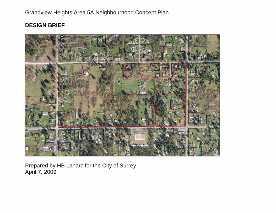
Grandview Heights Area 5A Neighbourhood Concept Plan DESIGN BRIEF
Prepared by HB Lanarc for the City of Surrey April 7, 2009
2
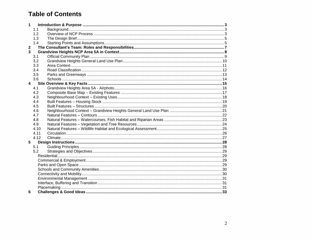
Table of Contents 1 Introduction & Purpose .................................................................................................................................. 3
1.1 Background ............................................................................................................................................... 3 1.2 Overview of NCP Process ........................................................................................................................ 3 1.3 The Design Brief ....................................................................................................................................... 5 1.4 Starting Points and Assumptions .............................................................................................................. 5
2 The Consultant’s Team: Roles and Responsibilities ................................................................................... 7 3 Grandview Heights NCP Area 5A in Context ................................................................................................ 8
3.1 Official Community Plan ........................................................................................................................... 9 3.2 Grandview Heights General Land Use Plan ........................................................................................... 10 3.3 Area Context ........................................................................................................................................... 11 3.4 Road Classification ................................................................................................................................. 12 3.5 Parks and Greenways ............................................................................................................................ 13 3.6 Schools ................................................................................................................................................... 14
4 Site Overview & Key Facts ........................................................................................................................... 15 4.1 Grandview Heights Area 5A - Airphoto ................................................................................................... 16 4.2 Composite Base Map – Existing Features ............................................................................................. 17 4.3 Neighbourhood Context – Existing Uses ................................................................................................ 18 4.4 Built Features – Housing Stock .............................................................................................................. 19 4.5 Built Features – Structures ..................................................................................................................... 20 4.6 Neighbourhood Context – Grandview Heights General Land Use Plan ................................................ 21 4.7 Natural Features – Contours .................................................................................................................. 22 4.8 Natural Features – Watercourses, Fish Habitat and Riparian Areas ..................................................... 23 4.9 Natural Features – Vegetation and Tree Resources .............................................................................. 24 4.10 Natural Features – Wildlife Habitat and Ecological Assessment ............................................................ 25 4.11 Circulation ............................................................................................................................................... 26 4.12 Climate .................................................................................................................................................... 27
5 Design Instructions ....................................................................................................................................... 28 5.1 Guiding Principles ................................................................................................................................... 28 5.2 Strategies and Objectives ....................................................................................................................... 29
Residential ....................................................................................................................................................... 29 Commercial & Employment ............................................................................................................................. 29 Parks and Open Space ................................................................................................................................... 29 Schools and Community Amenities ................................................................................................................. 30 Connectivity and Mobility ................................................................................................................................. 30 Environmental Management ........................................................................................................................... 31 Interface, Buffering and Transition .................................................................................................................. 31 Placemaking .................................................................................................................................................... 31
6 Challenges & Good Ideas ............................................................................................................................. 33

3
1 Introduction & Purpose
1.1 Background
The City of Surrey has hired a consulting team lead by HB Lanarc to complete a Neighbourhood Concept Plan for “Grandview Heights Area 5A,” as identified in the “Grandview Heights General Land Use Plan,” adopted by Council in 2005. HB Lanarc, Kerr Wood Leidal Engineering, and Bunt & Associates will work in conjunction with City staff on the preparation of this plan and will be building on previous studies. The NCP must be well-supported, technically robust and balance the needs of different stakeholders including landowners, residents of Grandview Heights and Surrey in general, the City and other government agencies.
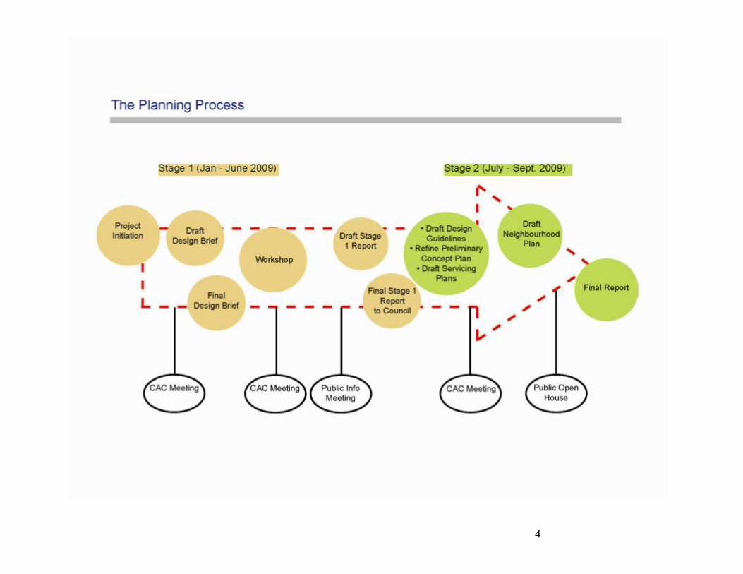
1.2 Overview of NCP Process
The General Land Use Plan for the Grandview Heights Community illustrates, in broad terms, the general land use pattern of the wider Grandview Heights area.
The NCP process will establish a more detailed land use concept for the area, including: location, type and density of various land uses, road network circulation and access, subdivision patterns, building and public realm design guidelines, pedestrian and bicycle networks and connections, the integration of environmental or local heritage features to be protected and enhanced, and the location of public parks, walkways and open spaces. The NCP for Area 5A will consist of two stages:
Stage 1 will result in the preparation of a land use concept and an overall servicing strategy.
Stage 2 will result in a finalized land use concept, design guidelines, calculation of
amenity contributions and a final servicing, phasing and financing strategies needed to implement the land use plan.
The NCP will be informed by relevant City regulations and policies, as well as background technical reports and studies completed or underway by consultants retained by the City. The planning process will be supported by a volunteer Citizens‟ Advisory Committee (CAC), made up of residents and property owners in and adjacent to the Study Area.
4
5
1.3 The Design Brief
The "design brief" provides a detailed set of instructions used to guide participants. These instructions have been crafted in response to policies contained within the City of Surrey‟s OCP, the City‟s Sustainability Charter, and the Grandview Heights General Land Use Plan, Transportation Strategic Plan, Employment Lands Strategy, Parks, Recreation and Culture Strategic Plan, as well as best practices in sustainability and Smart Growth, technical background studies of the Grandview Heights area, and from Citizen Advisory Committee and Project Steering Committee input. All of the various inputs outlined above have assisted in the formation and refinement of the guiding principles, objectives and strategies that form the basis of the design brief. The purpose of the design brief is to provide instructions that identify what the concept plan should achieve and the key deliverables that need to be produced. The brief does not specify how to plan and design. This is left to the design team to work out.
1.4 Starting Points and Assumptions
The plan that results from NCP process will focus on a balance of municipal objectives, land owner interests and community values. It uses as its starting points the goals and visions outlined in the Official Community Plan, the Sustainability Charter, and the General Land Use Plan for Grandview Heights. The OCP lays out a plan for the long-term viability of the City and its residents in economic, environmental and social spheres. The Sustainability Charter mirrors and enlarges the sustainability goals identified in the OCP, and sets out an implementation strategy. Included in this is the protection and preservation of environmental areas, provision of a diversity of housing and transportation choices for all residents, and the creation of a safe, inclusive and vibrant community identity.
The General Land Use Plan for Grandview Heights identifies more specific goals that pertain to the study area related to land use, transportation and open space. These include a mix of residential types and densities, small commercial nodes, community facilities, schools, parks, pathways, trees and protected areas. Attention is to be paid to the retention of watercourses, trees, and vegetation of environmental significance. View corridors of the mountains and the
6
ocean are to be protected. A modified grid road system, combined with greenways, is intended to both accommodate vehicle access and circulation and encourage residents to walk or cycle to nearby amenities. Overall, the community will retain lower residential densities throughout the central area. The projected population for the entire Grandview Heights neighbourhood at full build-out is expected to be between 20,670 and 32,870.
7
2 The Consultant’s Team: Roles and Responsibilities Don Crockett, HB Lanarc, Lead Designer – As a principal with HB Lanarc, Don has led numerous site planning projects in his more than16 years of experience, both in private consulting and municipal settings, with an emphasis on Parks, Landscape, and Urban Design. Don has developed computer and graphic skills to provide visualizations of complex planning and design scenarios, either in computer generated photorealism, or more traditional hand drawn renderings. Bruce Irvine, HB Lanarc, Project Lead – Bruce is market analyst and planner with extensive private and public sector experience. As a registered planner (MCIP, ACP), Bruce has worked on a variety of projects in Western Canada. Prior to joining HB Lanarc Bruce was the Vice President of Calgary Economic Development and a Manager of Current Planning at the City of Calgary. Steve Clarke, HB Lanarc, Designer – Steve is a licensed landscape architect in British Columbia and an adjunct professor at the University of British Columbia. His areas of specialization include sustainable landscape design and construction, urban trees, stormwater, green roofs and living wall technologies. Joaquin Karakas, HB Lanarc, Planner/Designer - Joaquin is a junior urban design planner with expertise in the preparation of detailed site plans and concept plans, housing studies and typology development, public realm and open space design, public event and design workshop facilitation, and urban design guidelines development. Sebastian Lippa, HB Lanarc, Planning Analyst – Sebastian holds a Masters degree in planning from UBC, and has a background in development planning and social sustainability. Ken Ferraby, Kerr Wood Leidal, P. Eng – Ken is a specialist in engineering planning, design and construction for land servicing and development with over 25 years of experience in consulting and contracting. His expertise covers land development servicing including water distribution, sanitary, and stormwater. Paul Dorby, Bunt & Associates, Transportation Planner - Paul is a Project Manager / Senior Transportation Planner and has provided consulting advice to private and public sector clients regarding all aspects of urban transportation for more than 15 years. His expertise includes traffic engineering, transit planning, urban street design, land development, transportation operations, parking supply and management, and transportation policy.
8
3 Grandview Heights NCP Area 5A in Context
This section presents the Grandview Heights Area 5A in the context of the Grandview Heights area and wider South Surrey community.
9
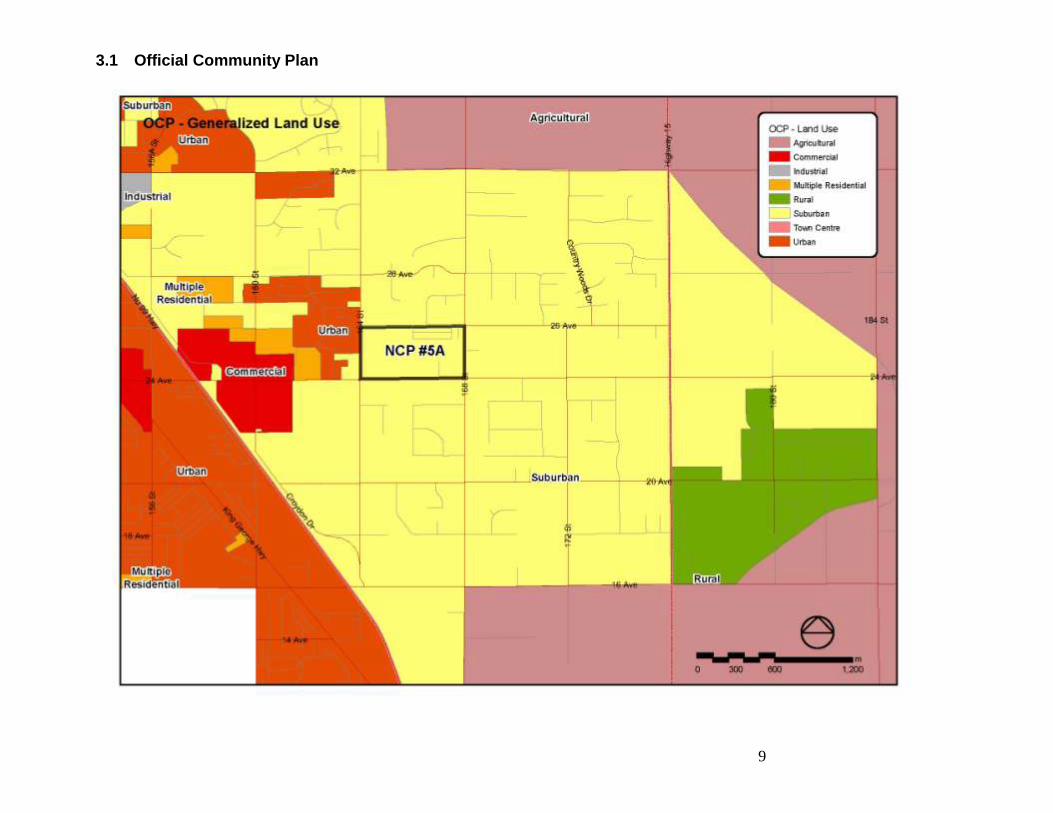
3.1 Official Community Plan
10
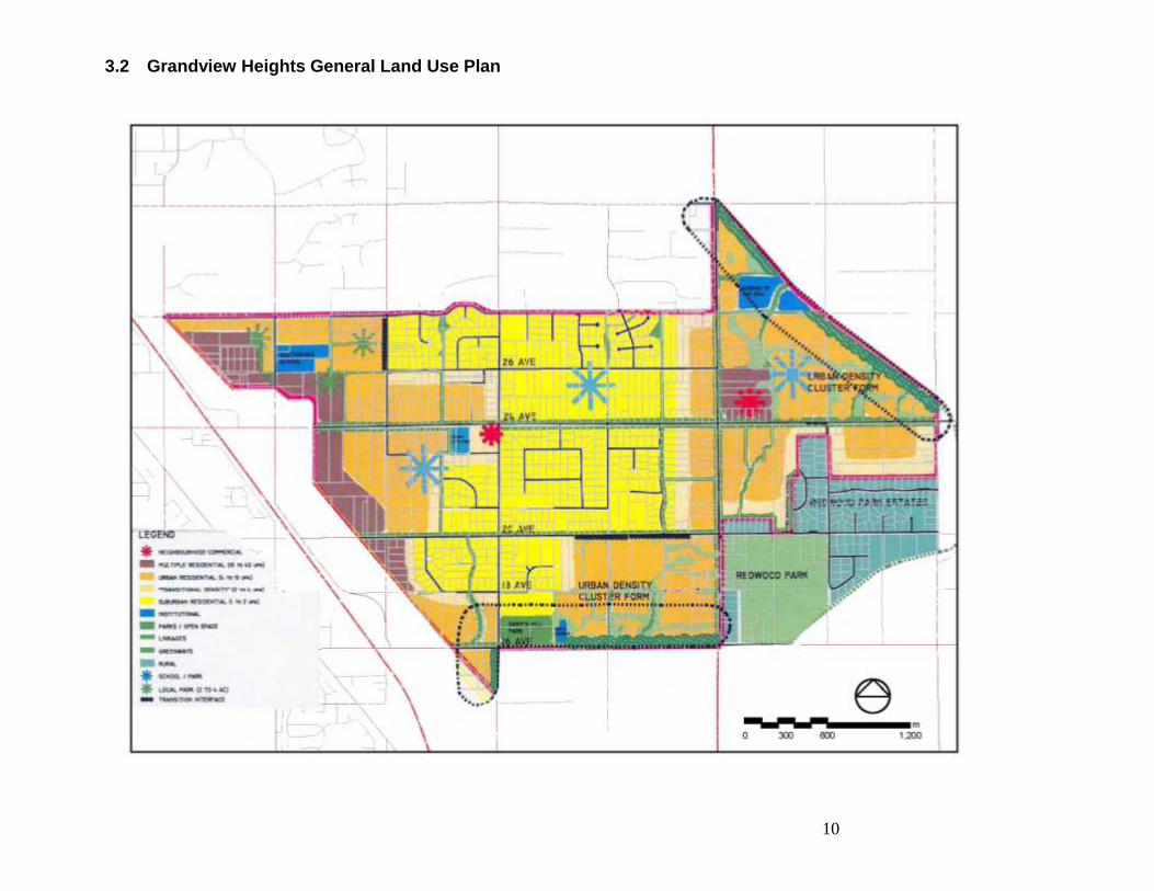
3.2 Grandview Heights General Land Use Plan
11
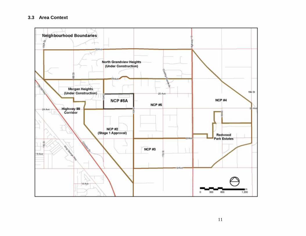
3.3 Area Context
12
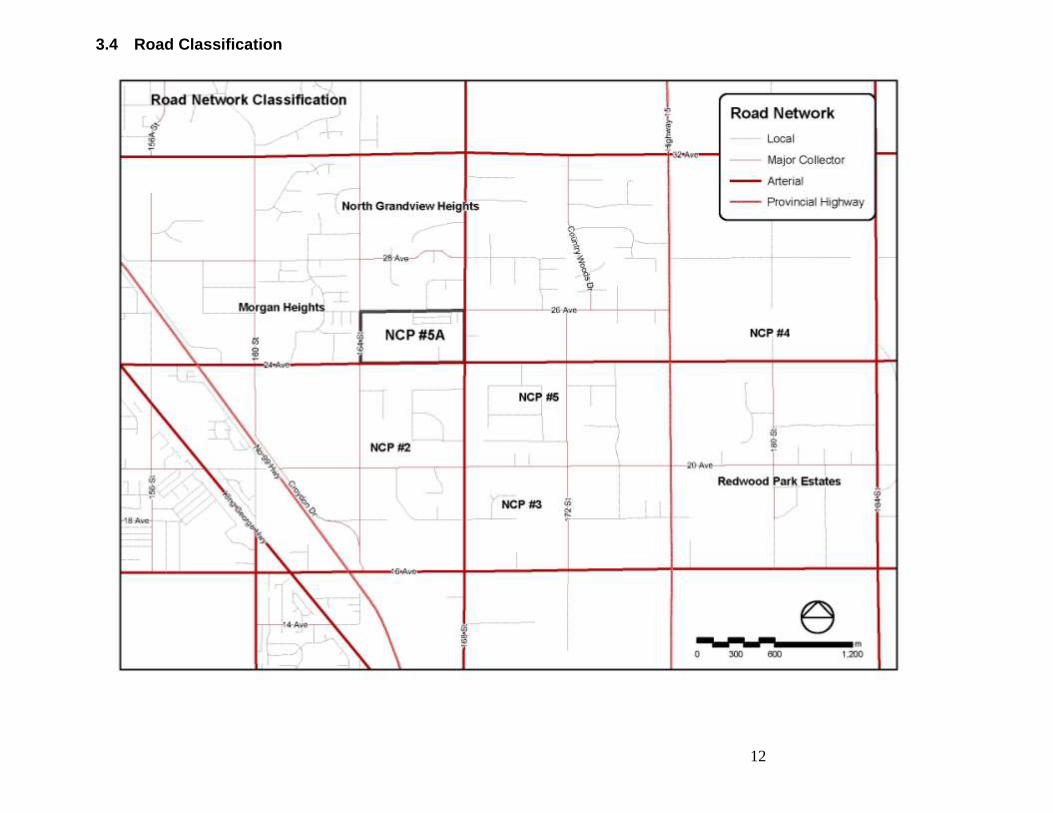
3.4 Road Classification
13
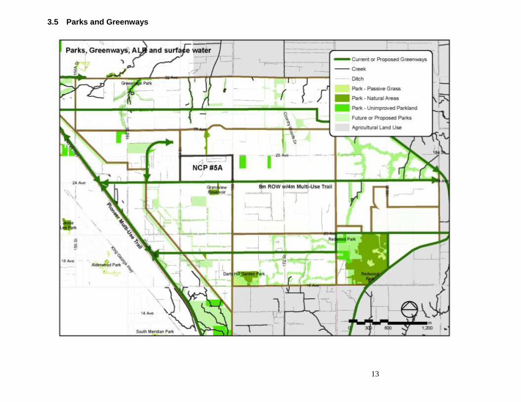
3.5 Parks and Greenways
14
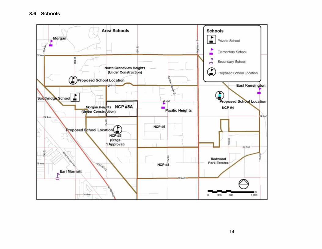
3.6 Schools
15
4 Site Overview & Key Facts This section presents a high level inventory of the site and overview of key site facts. This inventory will form the basis for further opportunities and constraints analysis which will in turn inform the development of conceptual design options for the site. The inventory is presented as a series of maps or „plates‟ to demonstrate visually key physical, legal, regulatory and contextual elements of the plan area.
16
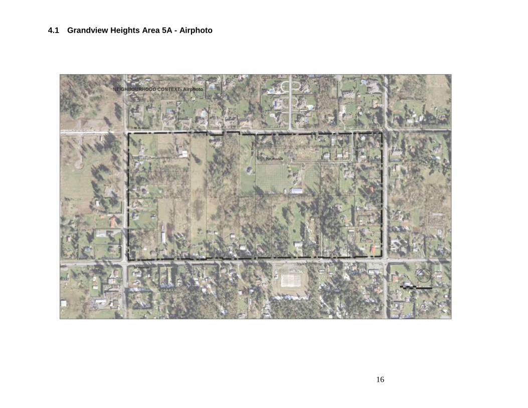
4.1 Grandview Heights Area 5A - Airphoto
17
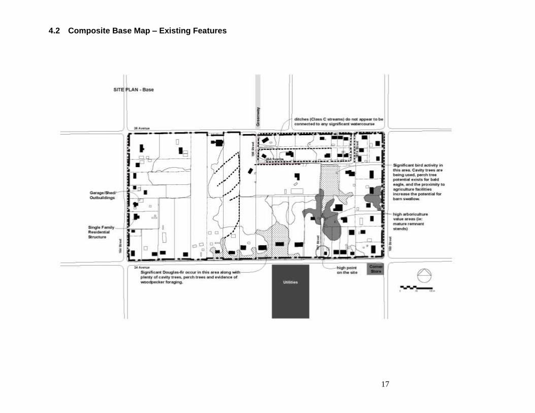
4.2 Composite Base Map – Existing Features
18
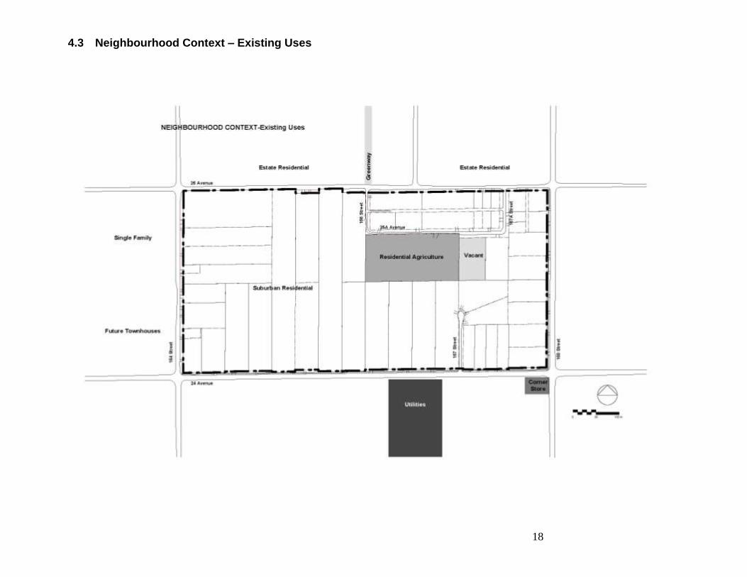
4.3 Neighbourhood Context – Existing Uses
19
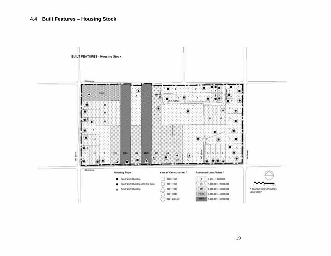
4.4 Built Features – Housing Stock
20
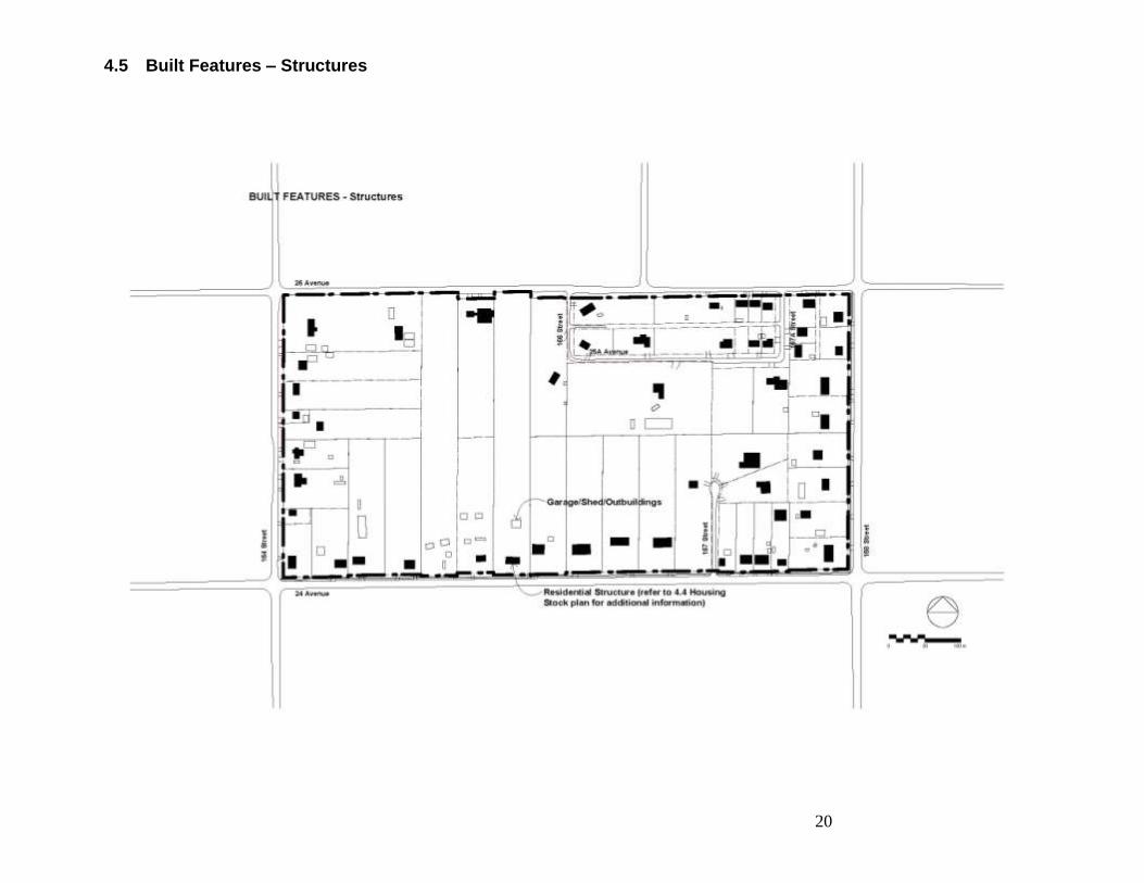
4.5 Built Features – Structures
21
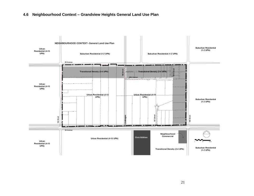
4.6 Neighbourhood Context – Grandview Heights General Land Use Plan
22
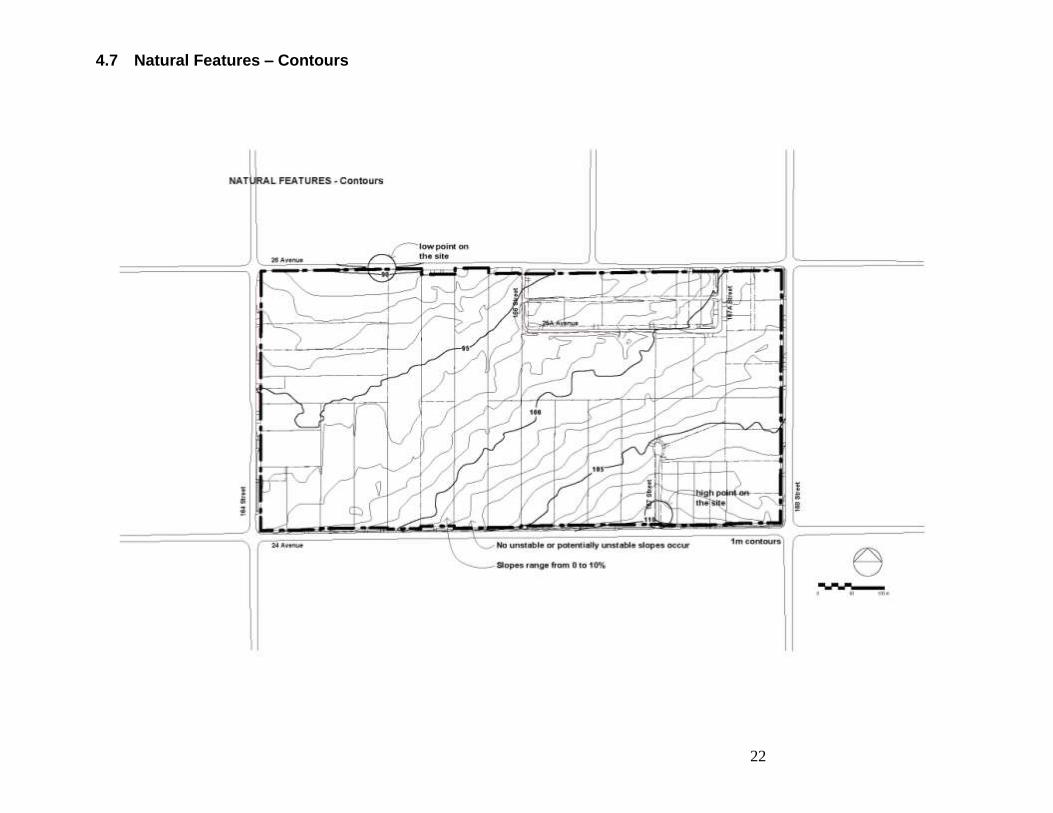
4.7 Natural Features – Contours
23
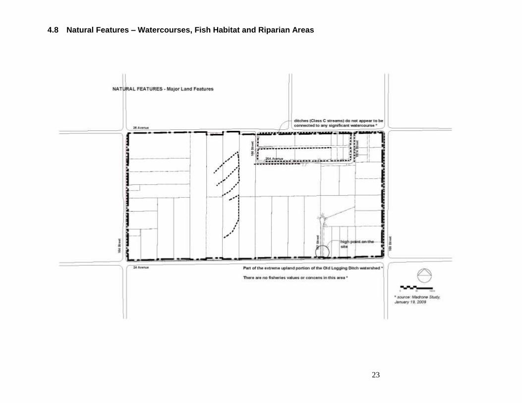
4.8 Natural Features – Watercourses, Fish Habitat and Riparian Areas
24
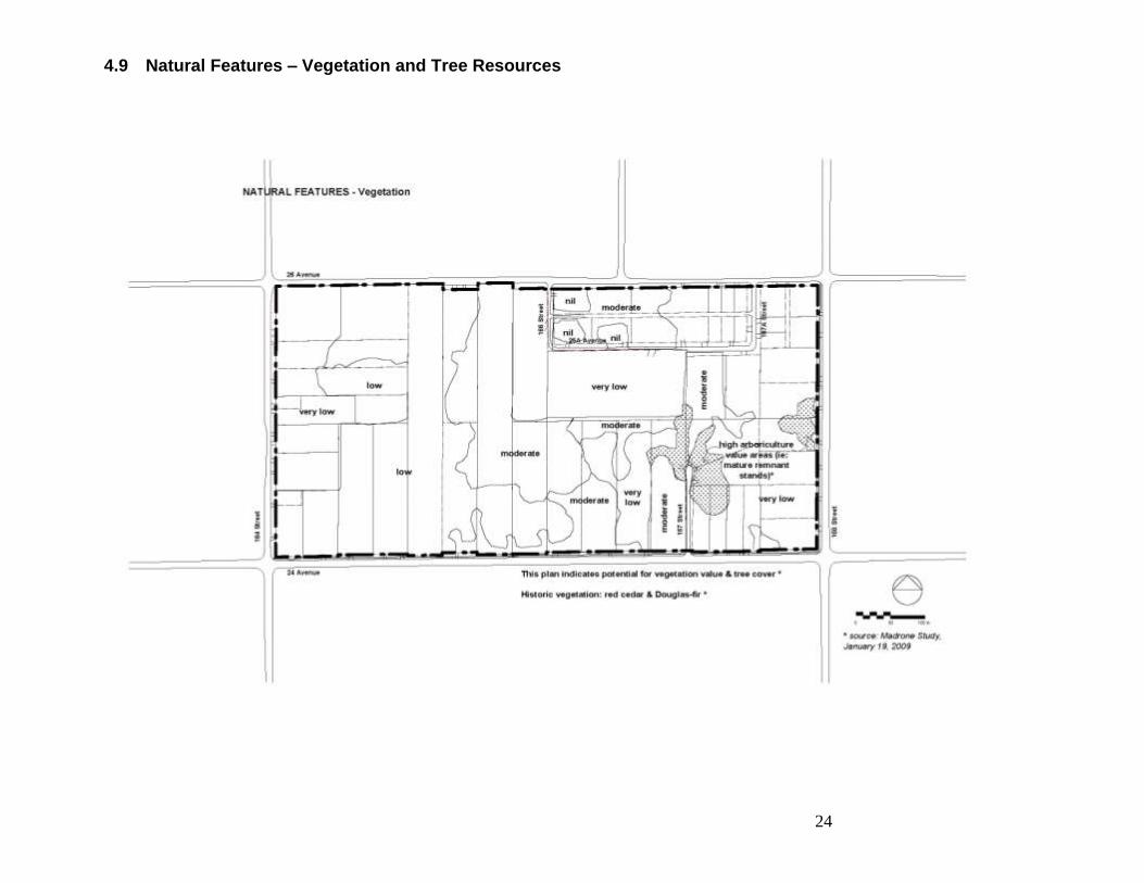
4.9 Natural Features – Vegetation and Tree Resources
25
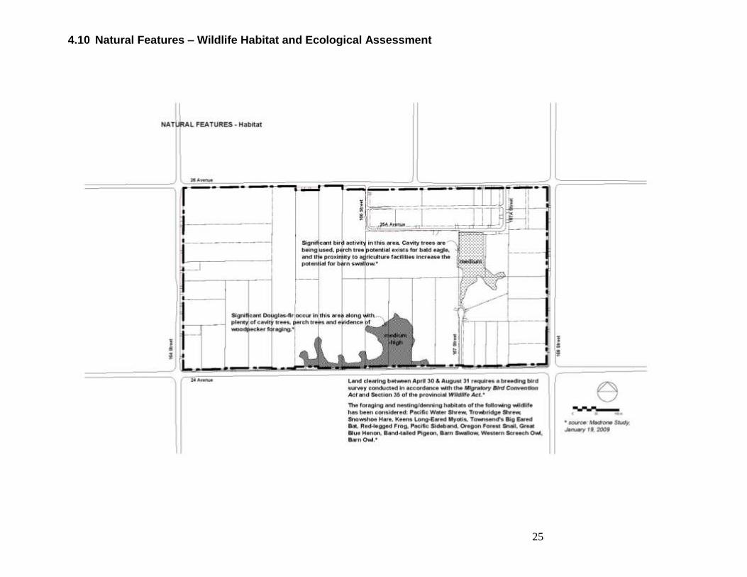
4.10 Natural Features – Wildlife Habitat and Ecological Assessment
26
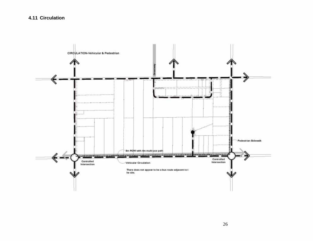
4.11 Circulation
27
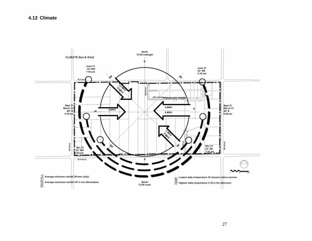
4.12 Climate
28
5 Design Instructions Several key City documents form the policy framework that is the foundation for the design instructions: Official Community Plan (OCP) Sustainability Charter (SC) Grandview Heights General Land Use Plan (GLUP) Transportation Strategic Plan (TSP) Parks, Recreation and Culture 2008-2017 Strategic Plan (PRCSP) Employment Lands Strategy (ELS) Relevant plans and policies in these documents, along with relevant technical background information summarized in section 3, were used to create the design instructions contained in this section.
5.1 Guiding Principles
Grandview Heights 5A will contribute to Surrey‟s overall vision of creating a complete and sustainable city made up of quality, vibrant and inclusive neighbourhoods with a high degree of amenity and sensitivity to the natural environment according to the following guiding principles:
1. Foster the creation of a high quality and walkable public realm that contributes to a unique neighbourhood character and identity.
2. Foster the creation of a neighbourhood that is inclusive, safe, healthy and diverse. 3. Provide opportunities for public recreation and social interaction. 4. Preserve valued habitat and natural open space. 5. Ensure a sensitive integration and connection with adjacent existing and planned
neighbourhoods. 6. Explore opportunities for providing local every day services and local employment for
residents where possible. 7. Ensure the greatest protection possible of ecological resources through incentives that
create a fair and equitable distribution of development opportunity.
29
5.2 Strategies and Objectives
Existing City policies and desired directions were combined in this section to create a set of strategies and objectives to be considered during the design process.
Residential
Provide a variety of housing choices. (OCP)
Explore options for clustering housing. (GLUP)
Explore green design and building practices for residential development. Promote sustainability at the neighbourhood, building and site scale. (SC)
Commercial & Employment
Consider the incorporation of small scale local-serving commercial uses. Ensure these commercial nodes will not adversely impact established residential areas. (GLUP; OCP)
Focus on an integrated development in the Grandview Heights/Highway 99 Corridor to encourage a mix of employment uses, including office and industrial and business park development. (ELS)
Parks and Open Space
Incorporate a tree management, preservation and enhancement strategy. (GLUP)
Foster the existing "green" ambiance through the retention and planting of trees, the provision of open space in developments, and the provision of park and natural areas. (GLUP)
Provide 1.2 hectares of land for neighbourhood parks per 1,000 residents. (PRCSP)
Initiate advance planning for the construction of a multi-purpose community recreation centre in Grandview. (PRCSP)
Enhance neighbourhood-level connectivity through extended sidewalks and narrower pathways, connecting residential areas with schools and pocket parks within the neighbourhood, and to the larger parks and circulation systems. (PRCSP)
Ensure that a neighbourhood park is located within a 10-minute walk from every new residence. (PRCSP)
Ensure the interconnection of parks, Greenways, and school walking routes with existing and proposed transit stops. (PRCSP)
Separate ecological and human uses in the parks and natural open space system where possible, and implement Low Impact Development practices where it is not possible. (PRCSP)
30
Complete linkages between Greenways to create a city-wide interconnected system. (PRCSP)
Schools and Community Amenities
Associate elementary schools with neighbourhood parks. Determine the location of the schools/parks, each of approximately 5.3 hectares (13 acres) in size. (GLUP)
Connectivity and Mobility
Establish local linkages within and between the plan area and surrounding neighbourhoods for both pedestrian and wildlife habitat purposes. Link main greenways to parks, neighbourhood commercial areas and other special features. (GLUP; OCP; SC)
Explore opportunities for pedestrian/bicycle greenways including along 24th Avenue and around the edge of Grandview Heights on the historic Railway right-of-way. (GLUP)
Minimize through-traffic from using local residential roads. (GLUP)
Examine opportunities for supporting transit service through appropriate location and density (clustered) and through transit network improvements. (SC; TSP)
Balance opportunities for walking, bicycling and public transit with opportunities for traveling by car within the City. (OCP)
Promote alternative and sustainable travel choice and provide better accessibility to jobs, education, health and recreation for all. (TSP)
Promote integration between transportation and land use to reduce the need to travel and support trips by more sustainable modes. (TSP)
To reduce congestion and support the sustainable economic development and vitality of Surrey, promote a grid road network and completion of missing links, and support spatial planning of new development that better aligns with alternative transportation opportunities. (TSP)
Towards reducing the impacts of transportation on the built and natural environment: o Promote alternatives to private car travel to help protect and enhance air quality and
reduce carbon emissions o Incorporate best practices for storm water management design into transportation
projects o Maximize enhanced greening of transportation corridors o Incorporate meandering of sidewalks and modifying road cross-sections to help
protect significant trees (TSP)
31
Towards promoting integration between transportation and land use to reduce the need to travel and support trips by more sustainable modes: o Densities identified within the future OCP update and new and updated NCPs to
incorporate and reflect all levels of Translink‟s Frequent Transit Network o Promote walking, cycling and transit through the application of sustainability
checklist o Promote community connectivity for all modes through the development of a finer
grid network and reduction in the number of cul-de-sacs o Undertake a review of the City‟s road concept plans to support improved routing
options and connectivity for all modes (TSP)
Environmental Management
Minimize the impacts of development on the natural environment. (SC)
Incorporate innovative storm water management practices in new developments in both private and public realms, including opportunities for ecological preservation, restoration and enhancement (e.g. natural areas and urban habitat). (SC; OCP)
Reduce energy and resource consumption in the built environment by maximizing opportunities for energy efficiency and alternative (renewable) energy resources. (SC)
Minimize solid and liquid waste. (SC)
Protect key view corridors of mountains and water. (GLUP)
Interface, Buffering and Transition
Ensure compatible frontage widths and building design for lots facing each other along the street. (GLUP)
Implement gradual changes in the size of lots from large to small, with changes in lot sizes to occur at the rear of lots. (GLUP)
Design landscaped buffers to provide for a compatible transition in density. (GLUP)
Ensure neighbourliness and a sensitive transition between different uses and scales of development. (GLUP)
Placemaking
Create a positive interface between building and streets. (OCP)
Reflect the heritage (natural and human history) of the site through building and streetscape design and the use of public art. (OCP)
Ensure pedestrian friendly sidewalks and streetscapes. (OCP)
Apply Crime Prevention Through Environmental Design (CPTED) principles to make streets safe, comfortable and welcoming for all users. (SC; OCP)
32
Consider special road and pathway standards that reflect the area‟s existing rural character and context. (GLUP)
Implement demonstration projects to promote best practices in sustainability such as natural drainage systems (e.g. permeable pavers) and improved lighting (e.g. energy efficient heads, white light and minimum spillover into adjacent buildings or the night sky). (SC)
33
6 Challenges & Good Ideas
The following are some initial design considerations in response to the policy and technical background information applicable to the study area. This is intended as a preliminary list to inform future discussion.
Investigate concept plan options for potential uses and densities that would support basic levels of transit service, local employment, limited commercial uses, along with other sustainability measures.
Opportunities for minimizing the overall ecological footprint of future development within
the plan area exist through appropriate neighbourhood patterning and design strategies as well as sustainability strategies at the site and building level.
Explore options to retain and renovate existing housing stock. Given the varying
building ages within the current housing stock, the design team may select from a series of tools that would promote sustainable options and timing choices for re-development through the inventory of existing housing stock and transition strategies.
Balancing respect for existing site characteristics with desired sustainability goals. This
could lead to the exploration of carriage houses, clustered housing, town houses, and live-work (among others) as potential development options.
While acknowledging the continued role of the automobile for future residents of this
neighbourhood, opportunities exist for pursuing non-motorized transportation to, from, through and within the plan area in the form of pedestrian and bicycle greenways and multi-modal streets.
Design elements that foster connectivity to surrounding services and amenities should
be further explored.
Although many of the current trees and other habitat areas are on private land, opportunities exist to pursue innovative solutions to ensure landowners and environmental priorities can be met.
Existing undeveloped land provides opportunities to pursue stormwater management on
site. (e.g., bioswales, retention ponds).
34
Cluster-housing provides the opportunity to preserve valued open space, to use land
and resources more efficiently, and enhance opportunities for interaction.
Explore opportunities for layering functional, recreational, and innovative storm water management elements. These also create opportunities for creating/enhancing neighbourhood identity.