granite tors of waldviertel (lower austria) as sites of...
TRANSCRIPT

19
http://dx.doi.org/10.7494/geotour.2015.40-41.19
Geotourism 1–2 (40–41) 2015: 19–36
Abstract: Granites of the South Bohemian Pluton are among the main rocks in the region of Waldviertel in the northern part of Lower Austria. The overall topography is gently rolling, with higher elevations and medium-altitude mountainous relief present only in the south-western part. Tors are the most characteristic residual landforms and occupy different settings, from mountain tops to valley floors. They vary in shapes and dimensions, with castle koppies and boulder clusters being most common. Many tors host well-developed microforms such as weathering pits, kar-ren, runnels, and flared slopes. Balanced rocks are among the highlights of the region. Because of good access residual gran-ite landforms of Waldviertel are well suited to be developed as geosites and geotourist destinations, but there is clearly a deficit of explanation and interpretation. In this paper 15 representative tors are presented, tourist infrastructure is summarized, and a the-matic one-day drive is proposed.Key words: granite, granite geomorphology, geosites, Bohemian Massif
Treść: Granity plutonu południowoczeskiego należą do głównych skał występujących w regionie Waldviertel w północnej części kraju związkowego Dolna Austria. Region ten odznacza się lek-ko falistą rzeźbą, z większymi wysokościami i górzystym ukształ-towaniem jedynie w części południowo-zachodniej. Skałki stano-wią najbardziej charakterystyczny element rzeźby denudacyjnej, zajmując różną pozycję morfologiczną, od szczytów wzniesień po dna dolinne. Są zróżnicowane pod względem kształtu i wymiarów, z dominacją zamczysk skalnych i zgrupowań bloków (skałek ru-mowiskowych). Morfologię wielu z nich urozmaicają mikroformy, takie jak kociołki wietrzeniowe, żłobki, rynny i nisze kloszowe. Szczególnie interesującym elementem rzeźby regionu są chybotki. Dobra dostępność sprawia, że rezydualne formy granitowe re-gionu są odpowiednie do zagospodarowania jako geostanowi-ska i atrakcje geoturystyczne, choć uwagę zwraca brak szerszego zaplecza edukacyjnego i interpretacyjnego. W artykule przedsta-wiono 15 reprezentatywnych skałek granitowych, podsumowa-no zagospodarowanie turystyczne obszaru oraz zaproponowano przebieg jednodniowej tematycznej trasy samochodowej. Słowa kluczowe: granit, geomorfologia granitowa, geostanowi-ska, Masyw Czeski
Granite tors of Waldviertel (Lower Austria) as sites of geotourist interest
Granitowe skałki regionu Waldviertel (Dolna Austria) jako obiekty geoturystyczneAleksandra Michniewicz, Milena Różycka, Piotr Migoń
University of Wrocław, Institute of Geography and Regional Development, pl. Uniwersytecki 1, 50-137 Wrocław, Poland
e-mails: [email protected]; [email protected]; [email protected]
Introduction
Geoheritage sites are the principal resources of geotour-ism and may have different values associated with them and exploited by tourism industry. Whilst scientific values of ge-osites are often emphasized in regional assessments, as they directly translate into educational opportunities to tell ge-oscientific stories, scenic component of geosites is equally important, at least from the perspective of tourism industry. This refers particularly to landforms which may take intrigu-ing, unusual, or even bizarre shapes and hence, would attract tourists whose interest in Earth history is minimal or non- -existent. Then, an opportunity arises to provide more in-depth explanation and interpretation. Thus, it is assumed that telling the story about rocks may be easier at natural rock outcrops rather than in quarries, particularly since in the for-mer case the story would be more comprehensive, involving near-surface processes and landform evolution too. In addi-tion, landforms are occasionally connected with folk tales and human history, providing links with cultural heritage.
The prime example of rock type that supports scenic land-scapes, often promoted as tourist destinations, is granite. The aesthetic aspect of the landscape is often related to the presence of tors, i.e. residual landforms originally defined as “solid rock outcrops as big as a house rising abruptly from the smooth and gentle slopes of a rounded summit or broadly convex ridge” (Linton, 1955, p. 455).
Numerous examples of successful exploitation of gra-nite heritage by tourism industry in general may be provid-ed, from Europe and elsewhere. These are tors and crags of Fichtelgebirge in Germany, including the famous “rock city” of Luisenburg (Hundert Meisterwerke... 2012), the Pink Gra-nite Coast in Brittany (France) (Lageat, 2013), or the upland of Dartmoor in south-west England with its multitude of tors (Campbell et al., 1998). Selected areas from outside Europe include granite geoparks of China such as Huangshan and Sanqingshan (Migoń, 2007; Cui et al., 2009), both also list-ed as UNESCO World Heritage properties, Matopos hills in Zimbabwe, and Joshua Tree National Park in the Mojave De-sert of southern California. Singular localities are Wave Rock and Devil’s Marbles, both in Australia (Twidale, 1968, 1982).
Compared with these worldwide known destinations, granite rock formations of Waldviertel in Lower Austria are of regional significance rather than enjoy wider recogni-tion. Numerous tors and boulder fields have been often re-ported in the literature, but invariably local (see Huber, 1999

20
Granite tors of Waldviertel (Lower Austria) as sites of geotourist interest
for extensive bibliography). Nevertheless, even the litera-ture survey alone indicates that the quantity and diversity of rock formations in Waldviertel, including minor features on rock surfaces, is exceptional, at least at the Central European scale. Hence, they are valuable assets for geotourism which so far is hardly supported by existing facilities and infrastruc-ture.
Consequently, the aims of this contribution are threefold. First, more than a dozen of representative localities of granite residual landforms from Waldviertel are presented in a de-scriptive way, to show the value of granite geoheritage. Sec-ond, existing infrastructure is reviewed and evaluated. Third, a regional thematic geoheritage trail linking some key local-ities is proposed.
Study area – location, geology and landscape
The area considered in this paper is located in northern part of Austria, in the administrative state of Lower Austria (Niederösterreich), and in the region known as Waldviertel. However, the focus is not on the entire Waldviertel, but on its north-western part, along the border with the Czech Republic, between the towns of Weitra in the south-west and Kautzen in the north-east (Fig. 1). This area, approximately 45 km wide long and up to 20 km wide, is broadly coincident with the out-crop area of Eisgarner Granite, with minor representations of other granite variants. Further to the east, metamorphic rocks prevail or Weinsberger Granite occurs, which gives rise to re-sidual rock landforms much less frequently. The main urban
centre of the region, also the main tourist centre, is the town of Gmünd, located at the state border.
Geologically the area is part of the South Bohemian Ba-tholith – the largest plutonic body in the Bohemian Massif, which in turn belongs to the Moldanubicum Unit of the Bo-hemian Massif (Koller, 1999). It is lithologically complex and consists of several distinctive granitoid units of different ages, testifying to multi-phase magmatic activity during the Variscan orogeny. Eisgarner Granite, which is the main tor- -supporting lithology, is medium-grained, in places porphy-ritic, two-mica granite. Its emplacement took place between 333 Ma and 315 Ma, during a later stage of the orogeny. Local finer or coarser variants may be even younger. Weinsberger Granite is older (350–335 Ma) and more deformed. Coarse-grained textures and large potassium feldspars are typical. Both variants show well-developed jointing, typically regular and orthogonal, but with variable joint spacing. Therefore, densely jointed compartments may occur side by side with very mas-sive fragments, with visible discontinuities spaced as much as 3–4 m (horizontal) and more than 10 m (vertical) apart.
The later history of granite intrusions is poorly con-strained, although it is likely that granites were unroofed in the latest Palaeozoic or early Mesozoic, suffered from pro-tracted denudation and formed a low-relief terrain in the Cretaceous, when marine transgression took place in the marginal parts of the Bohemian Massif (Höck, 1999). Up-per Cretaceous sediments laid down in a lacustrine environ-ment occur in the town of Gmünd itself (Huber, 2003), a few kilometres from the nearest granite outcrops. However, the boundaries of the Cretaceous rock outcrop area are fault-con-trolled (Huber, 2003) and no recent exhumation of granite surfaces from beneath Cretaceous strata may be inferred.
Fig. 1. Location of granite tors in north-western Waldviertel and propos-al of a granite thematic drive. Tor lo-calities: 1 – 5 – Blockheide (Pilzfels, Christophorusstein, Wackelsteine, Teufelsbett, Koboldsteine), 6 – Wa-ckelstein near Amaliendorf, 7 – Hän-gender Stein, 8 – Geyersteine, 9 – Gu-gelhupfstein, 10 – Hutstein, 11 – Hoher Stein, 12 – Teufelsstein, 13 – Mandl-stein, 14 – Nebelstein, 15 – Dreilö-cherstein • Lokalizacja skałek grani-towych w północno-zachodniej części Waldviertel i propozycja tematycznej trasy samochodowej. 1–15 – numeracja form skałkowych.

21
Granite tors of Waldviertel (Lower Austria) as sites of geotourist interest
The Cenozoic history of the area is unknown in details and typically presented using analogies to other, better re-searched terrains (Höck, 1999). The subdued topography of Waldviertel north of Gmünd (Fig. 2) is interpreted as a sur-face formed by selective deep weathering followed by strip-ping of weathering products, with alternating elevations and troughs. Tors are typically associated with the former, al-though they may occasionally rise from the floors of topo-graphic lows too. Ridge altitudes are close to 600 m a.s.l., occasionally a little more (e.g. Hoher Stein, 666 m), whereas valley bottoms are at 500 m a.s.l. By contrast, to the south-west of Gmünd the terrain rises to form a medium-altitude mountain terrain of Gratzener Bergland (Novohradské hory in the Czech Republic), with a number of peaks exceeding 1000 m a.s.l. A few localities from the north-eastern margin-al part of this mountain terrain are considered here, including Nebelstein (1017 m), one of the highest in the region. Ele-vation differences between ridges and basin floors are up to 350–400 m.
Geodiversity of granite terrains
The South Bohemian Batholith, in the Austrian and ad-jacent Czech territory alike, is long known for its diversity of denudational landforms built of granites. Interpreted as an exposed weathering front – an etchplain (Czudek et al., 1964; Huber, 2003), it features a range of medium-size and minor landforms. The former include classic tors in a variety of
shapes, rock cliffs across the slopes, pedestal rocks, including rocking stones, isolated boulders and boulder clusters, angu-lar block fields and block streams (Votýpka, 1964; Věžník, 1982; Chábera, Huber, 1995, 1999; Huber, 1999). Rocking stones are of particular interest, not only as rare natural phe-nomena, but also as localities visited since the early days of tourism. The cluster of such balanced boulders (Wackelsteine in German) in Blockheide near Gmünd is among the high-lights of the area, while the boulder Trkal in the Czech part was country-wide famous for its ability to move until recent minor displacement stabilized it (Věžník, 1982).
Tors and boulders host an astounding variety of minor fea-tures related to selective weathering of rock surfaces. Whilst abundant weathering pits (Votýpka, 1964; Věžník, 1982; Hu-ber, 1999) may be considered typical for granite outcrops in the Bohemian Massif (Czudek et al., 1964), other features are indeed exceptional in terms of frequency of occurrence and clarity. These include particularly karren and flared slopes, but also polygonal cracking, pseudobedding, roofed and un-roofed clefts and crevice caves (Chábera, Huber, 1995, 1996, 1998; Huber, Chábera, 1993, 1994).
Tor localities
From a large population of tors in Waldviertel a sample of 15 individual localities has been selected and is charac-terized in detail. These tors either best represent the diver-sity of granite residual rock formations in the region, or are
Fig. 2. Rolling countryside of northern Waldviertel, near Haugschlag. Note large granite boulders exposed due to erosion of weather-ing mantles, photo P. Migoń • Falisty krajobraz północnej części Waldviertel koło Haugschlag. Uwagę zwracają duże granitowe bloki odsłonięte wskutek usunięcia pokrywy zwietrzelinowej, fot. P. Migoń

22
Granite tors of Waldviertel (Lower Austria) as sites of geotourist interest
popular tourist/sightseeing destinations, or preferably both. Their presentation is divided into four sections, focused on specific parts of Waldviertel.
BlockheideBlockheide Nature Park is a protected area to the east of
the town of Gmünd, which is famous for the abundance of granitic tors and boulders and hence, frequently visited and promoted as one of main tourist attractions of the region. The overall topography is rolling, with wide troughs alternating with gentle swells. Altitudes do not exceed 600 m a.s.l. All tors and boulders in this area are built of Eisgarner Granite. Among numerous rock formations in Blockheide the follow-ing five are most spectacular.
Pilzstein. Pilzstein is one of the symbols of Blockhei-de. Reaching the height of 4.5 m and being approximately 6.5 m long and wide alike, the tor consists of two spherically shaped, massive blocks superimposed upon a rather narrow and thin stem (Fig. 3). The larger cap block (c. 40 m2, 2 m thick) rests on the smaller one. The stem is built of dense-ly fractured granite, with several sub-horizontal joint surfac-es dipping at low angle. Cavernous weathering occurs along the joints. The depth of overhang beneath the cap varies and reaches more than 2 m on the western side. Pilzstein, as most of the tors in Blockheide, is located next to a marked trail and is frequently visited. However, no other information board than the simple plaque with the tor name exists in the vicin-ity of the site. Pilzstein has been described in the literature (Chábera, Huber, 1995; Huber, 1999) as a prime example of
‘mushroom’ rocks. Next to Pilzstein a large number of boul-ders and/or hemispherical granite outcrops occurs. Some of them show well developed flared slopes, including tiered ones.
Christophorusstein. Christophorusstein (Fig. 4) is per-haps the largest singular tor in Blockheide, located in its southern part, in a slope setting. It is 22 m long and 7 m high, and – being an example of a castle koppie – consists of sever-al compartments separated by deep clefts developed as a re-sult of widening of vertical joints striking SW–NE. A notable feature is fairly regular pseudobedding, with the thickness of particular slabs exceeding 1 m. Morphology of the upper surface of the tor is diversified by minor features, including ten weathering pits of various dimensions (Fig. 5). The larg-est one is 1.8 m long, 1 m wide and 0.3 m deep. Christopho-russtein is easily reached by a marked trail and clearly visible despite forest location. A stone-made board with the name of the tor has been placed nearby, whereas an information panel next to the tor presents the legend of Christophorus Rock and explains the name. It is also a part of the thematic GRANITkulTOUR trail which connects more than ten local-ities in SE section of Blockheide. A small plaque attached to the rock form gives information of its protected status.
Wackelsteine. Among the highlights of Blockheide are several perched boulders resting on rock platforms, which show (or showed) ability to move and are called Wackel-steine (Chábera, Huber, 1995). The largest balanced rock, located in the southern part of the area, close to Christo-phorusstein, is 9.3 m long and reaches 2.5 m high (Fig. 6).
Fig. 3. Pilzstein, with a large overhang on the western side, photo M. Różycka • Pilzstein ze znacznych rozmiarów przewieszką od strony zachodniej, fot. M. Różycka

23
Granite tors of Waldviertel (Lower Austria) as sites of geotourist interest
Fig. 4. The shape of Christophorusstein is related to the presence of thick slabs of massive granite, photo P. Migoń • Kształt Christophorus-stein nawiązuje do obecności grubych płyt masywnego granitu, fot. P. Migoń
Fig. 5. Weathering pits on the upper surface of Christophorusstein, photo P. Migoń • Kociołki wietrzeniowe na powierzchni szczytowej skałki Christophorusstein, fot. P. Migoń

24
Granite tors of Waldviertel (Lower Austria) as sites of geotourist interest
A large elongated rounded boulder lies on an upward-convex platform, slightly protruding from the ground. The length of the pedestal is 7.3 m. The upper boulder is massive and bare, only partially covered by mosses in the top part. In contrast to the nearby Christophorusstein no specific microrelief typifies its surface, which is probably related to boulder instability, unfavourable for localized higher efficacy of weathering. The site is easily accessible and well signposted, located next to the GRANITkulTOUR trail. The name of the rock group has been carved in a stone-made board placed near the site, but otherwise no further explanation or interpretation is offered. Two other balanced rocks, both of smaller dimensions, are present in the eastern part of the area and signposted.
Teufelsbett and Teufelsbrotlaib. Teufelsbett and Teufels - brotlaib are excellent examples of very large, monolithic granite boulders which dot the rolling countryside around Gmünd. The larger among the two, an elongated Teufelsbett reaches height of 4.2 m and length of 10.6 m (Fig. 7). Very few joints present within the boulder divide the outcrop into three spherically-shaped parts resembling a bed, a pillow and a duvet. There is no evidence of mechanical disintegration in the vicinity of the boulder, nor are minor forms related to biochemical weathering such as karren and pits visible on the rock surface. The adjacent Teufelsbrotlaib is slightly smaller, 4.2 m high and 6.2 m long, and more ball-shaped. On the curved rock surfaces exfoliation sheets are present. Both boulders are located at the intersection of walking trails running around Blockheide, and separated from each other by c. 20 m. They are very well exposed and easily accessible. The rock-cut boards with the name of an object have been
placed next to them, as well as are small plaques indicating their status as protected nature monuments.
Koboldsteine. Koboldsteine are located in the north- -western section of Blockheide, c. 200 m north from the obser-vation tower. The name was given to a series of well-rounded boulders and monoliths along the crest of a local N–S stretch-ing terrain convexity, across the distance of approximately 50 m. Individual compartments reach up to 5 m high and are separated by vertical fractures of W–E extension which in places turn into open fissures up to 2 m wide. The entire rock formation is divided into three groups of closely-spaced boulders, whereas in between them bedrock outcrops are missing. On top of one such a boulder a balanced rock (2 m high) is present. The evidence of block sliding can also be observed, as well as two generations of flared slopes near the base of some boulders. Koboldsteine are easily accessi-ble and well-exposed despite surrounding trees, marked by a board indicating the name. Yellow and pink-marked trails connect them with other sites of interest in the vicinity.
Tors in northern WaldviertelWackelstein near Amaliendorf. Approximately 4 km
north of the town of Schrems and 1.5 km west from Ama-liendorf, a cluster of large monolithic granite blocks amidst an open pine forest is present. The most popular among them is Wackelstein which is yet another example of balanced rocks in Waldviertel (Chábera, Huber, 1995). The perched boulder is 3 m high and 5 m long, and rests on a flat pedes-tal. Its bottom part is convex downward which results in its instability.
Fig. 6. Wackelstein II is the best example of balanced rock in Blockheide, photo P. Migoń • Wackelstein II jest najlepszym przykładem chybotka w Blockheide, fot. P. Migoń.

25
Granite tors of Waldviertel (Lower Austria) as sites of geotourist interest
The upper part of the boulder is hemispherical and has smooth outer surface, except for the series of small notches hollowed in one side of the block. In the vicinity of Wack-elstein other interesting boulders are located. Next to the balanced rock large, massive compartments with well- -developed weathering pits, some as long as 1.5 m, occur. Furthermore, lower sides of certain blocks show classic ba-sal concavities, known as flared slopes and indicative of shallow subsurface weathering, some up to 10 m long and 0.5 m high. A rare phenomenon, with a few equivalents else-where, is a pair of flared slopes on two adjacent boulders facing each other and separated by an open cleft (Fig. 8). In addition, rock outcrops near Amaliendorf show signs of quarrying, both in the form of stone quarries as well as split boulders.
Wackelstein is a nature monument, although it is not marked on all tourist maps. The easiest access to the site is from Amaliendorf, from where a forest road and a marked trail lead to the site. On the edge of the forest, where is space to park a car, an information board has been erected.
Hängender Stein. The tor group is located c. 1.5 km south-east from the centre of Heidenreichstein, at the altitude of 606 m a.sl. Morphologically, Hängender Stein is a bipartite tor, with the tabular shape influenced by prominent, low angle dipping joints. The northern part is 7.2 m long, 2.5 m high and elongated in N35E direction, along parallel vertical joints. One weathering pit has evolved on the surface of this part. Joints perpendicular to those mentioned above (N335W) determine the outline of the southern section of the tor. This part is elon-gated too and longer than the northern one, reaching 8.8 m. The top part is made of a large ʻhangingʼ block, 5 m long and 3 m high, narrowing toward the base. Its upper surface is di-versified by more than 20 linear furrows of variable length (0.3–4 m) and depth (1–25 cm) (Fig. 9), which either dissect the edge of the tor (karren) or form dendritic patterns on its upper surface (runnels) (Huber, Chábera, 1993).
The tor is situated in the Gemeindewald, whose area is easily accessible through a network of marked trails. The tor is best reached from a parking near the Heidenreichstein – Johanessiedlung road and the walk takes approximately 15 minutes. Tourist facilities next to the site include bench-es and an information board. It is the only site among those presented in this paper where the origin of granite tors in two stages (deep weathering followed by selective erosion) is ex-plained and graphically presented. Gemeindewald is a local protected area.
Geyersteine. The tor is located 3.3 km west from Heiden-reichstein and 1.5 km to the south-west from the village of Altmanns, at the altitude of 545 m a.s.l. The outcrop, 7 m high in total, rises from the steep left side of a valley formed by the tributary of the Braunaubach stream.
Fig. 7. Teufelsbett (right) and Teufelsbrotlaib (left, in the background), photo P. Migoń • Teufelsbett (po prawej) and Teufelsbrotlaib (w tle po lewej), fot. P. Migoń
Fig. 8. A pair of flared slopes along a widened joint-controlled defile between two granite outcrops, near Amaliendorf, photo P. Migoń • Para nisz kloszowych wykształconych wzdłuż posze-rzonej szczeliny pomiędzy dwiema wychodniami granitu, w pobli-żu Amaliendorf, fot. P. Migoń

26
Granite tors of Waldviertel (Lower Austria) as sites of geotourist interest
Geyersteine consist of three ‘mushroom’ rocks whose caps once formed a continuous massive slab more than 2.5 m thick (Fig. 10). Granite below is densely parted by horizontal joints, whilst the upper slab is divided into separate residuals along SSW–NNE vertical joints. The upper edges of all boul-ders building the form are rounded and their surfaces are di-versified by karren covered by mosses. Elevation difference between the top of the tor and the valley bottom is c. 9 m. The valley floor, more than 20 m wide, is made of densely packed boulders, most probably exposed through preferential fluvial erosion of loose regolith. The tor group of Geyersteine has been described as a residual landform resulting from long-term etchplanation processes (Chábera, Huber, 1995).
Geyersteine are of local cultural significance. On one of the boulders, at the foot of the tor, a stone plaque to com-memorate Franz Geyer, a local Waldviertel composer, has been erected. The site can be easily reached from two forest roads accessible to cars, and the distance to the tor is identi-cal (250 m, 5 minutes). There are no tourist facilities near the Geyersteine, with the exception of the wooden bridge leading to the outcrop. The rock formation is well exposed despite its location in a rather dense forest.
Gugelhupfstein. Gugelhupfstein (or Wetterstein) is a large rock outcrop built from Eisgarner Granite, located c. 120 m to the west from the road connecting the towns of Heidenre-ichstein and Eisgarn, approximately halfway the distance be-tween them. Outcrop altitude is about 570 m a.s.l. It is not a classic upstanding tor, but rather a rocky section of the steep
side of Räubersgraben valley that rises above its flat floor. The rock wall of Gugelhupfstein is about 55 m long and follows three directions of vertical joints in granite (N72E, N305W, N–S), which account for its broken course in ground plan. Maximum height is 6 m in the northern part. Here, a 3 m high pedestal rock rises above the upper rock platform, with a shape resembling an anvil. Its highest part is dissected by densely spaced karren up to 3 m long, 10–50 cm wide and up to 28 cm deep (Fig. 11). Alternating karren and intervening ribs give distinctive appearance to the outcrop, although they are largely overgrown by mosses. Next to the karren, on the west-facing side, a large flared slope, c. 1.5 m deep, is present at the base of the pedestal rock. The main rock wall is densely fractured and broken into large blocky compartments in the outer parts. The biggest of them forms an overhang which is 2.2 m high, 5.5 m long and 1.8 m deep. Gravitational displacement of one such block located at the rock wall base caused the origin of a nar-row open fissure through the rock spur, 1.5 m high and 20–30 cm wide. Approximately in the middle of the rock wall, a few metres in front of it, a large triangular granite monolith lies, 3.6 m high and 5 m long. Orientation of its sides is consistent with the principal joint directions in the rock face, suggesting that the monolith is a residual from selective weathering of non-uniformly jointed granite.
Gugelhupfstein is located in a spruce forest, away from marked trails. A small plaque next to the pedestal indicating its status as a protected nature monument is the only sign of management.
Fig. 9. Dendritic pattern of rills on the upper surface of Hängender Stein, photo P. Migoń • Dendrytyczny układ rynienek na górnej powierzchni Hängender Stein, fot. P. Migoń

27
Granite tors of Waldviertel (Lower Austria) as sites of geotourist interest
Fig. 10. Rock formations of Geyersteine, photo P. Migoń • Formacje skalne Geyersteine, fot. P. Migoń
Nevertheless, the outcrop has been described in scientif-ic publications and is considered as one of the finest exam-ples of granite karren and flared slopes in the region (Huber, Chábera, 1993, 1994; Huber, 1999).
Hutstein. Hutstein is a singular tor located to the east from the village of Haugschlag, close (less than 1 km) to the Austrian-Czech boundary, on the valley side of the Raiss-bach valley. The height of Hutstein is 5 m. The tor itself is another example of a ʻmushroomʼ rock and consists of two parts (Fig. 12). The upper one, forming the hat, is dissected
by numerous karren which in conjunction with parallel ribs create distinct surface micromorphology. The deepest kar-ren are on the east side of Hutstein, with some continuing on the surface of the lower part of the form – the pedestal, but these are poorly developed. Minor weathering forms of Hut-stein, not yet overgrown (as in the case of Gugelhupfstein), are considered among the best example of granite karren in the region (Huber, 1999). The tor is hidden in the forest, but access is signposted. There is a small plaque next to Hutstein indicating its name.
Fig. 11. Moss-overgrown karren of Gugelhupfstein, photo P. Migoń • Pokryte mchem żłobki na skałce Gugelhupfstein, fot. P. Migoń
Fig. 12. Karren on Hutstein, photo P. Migoń • Żłobki na skałce Hutstein, fot. P. Migoń

28
Granite tors of Waldviertel (Lower Austria) as sites of geotourist interest
In addition, an area immediately to the east of Hutstein is of geotourist interest because of an abundance of granite boulders and their good visibility in open agricultural terrain (Fig. 13).
Some of these monolithic boulders attain length of 8 m. They are well rounded and host flared slopes which provide good evidence that boulders formed in the subsurface and have been excavated from weathering mantles through reg-olith removal.
Tors near Kautzen (NE Waldviertel)
In the vicinity of the village of Kautzen, close to the Czech border, the terrain rises to higher elevations, with hilltops ex-ceeding 650 m a.s.l. Two of them – Hoher Stein (666 m) and Pyramide (663 m), host interesting rock formations.
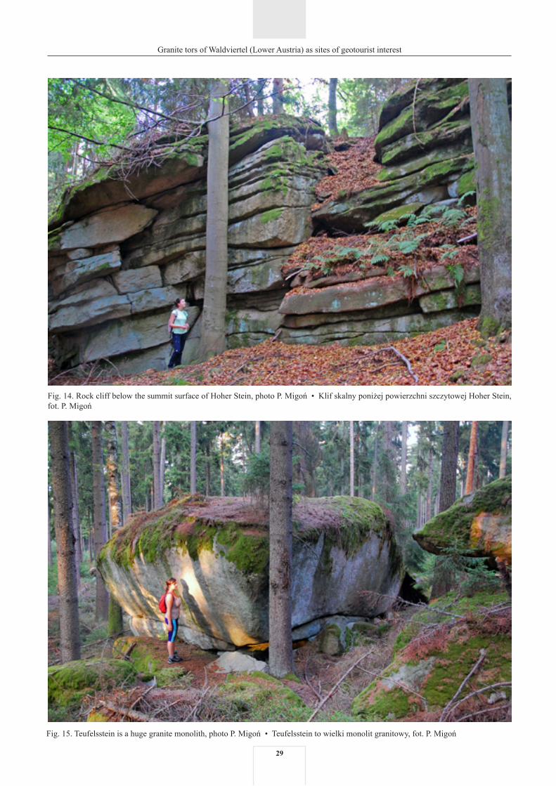
Hoher Stein. Under this name, two adjacent tors below the summit are considered. Their location is to the north from the vil-lage of Illmau, about 750 m southward from the Czech-Austri-an border. Both are north-facing edge tors and constitute a sharp break of slope below the flattened summit surface. Bedrock is Eisgarner Granite. Two rock cliff sections are approximately 30 m away from each other and both follow the same WNW–ESE direction. The eastern cliff (Fig. 14) is 32 m long and up to 8 m high, the western one is 13 m and 7 m, respectively. Both are built of a rock typified by distinct sub-horizontal partings spaced by about 1 m, and are further dissected by vertical fractures, perpendicular or oblique to the general direction of the cliffs.
At the intersection with one such fractured zone a triangular hollow 5 m high and 6.5 m deep has developed in the eastern cliff. Rock cliffs disintegrate due to block fall along primary joints and secondary, tensional fractures parallel to the cliff face. Chaotic blocky talus mantles the surface below the cliffs and continues downslope.
Fig. 13. Large granite boulders and exposed rock platforms in open terrain east of Haugschlag, photo P. Migoń • Wielkie bloki granitowe i platformy skalne na otwartej przestrzeni na wschód od Haugschlag, fot. P. Migoń
There are three marked trails in the vicinity of tors, with signposted directions to the cliffs. However, no other tourist infrastructure exists at the site, nor is an information panel present. Although the cliffs are in forested terrain, they are reasonably well exposed. In regional literature they have been described as examples of frost-riven cliffs, i.e. denuda-tional landforms causally related to the Pleistocene perigla-cial environment (Chábera, Huber, 1999).
Teufelsstein. An elongated crest of Pyramide is crowned by a discontinuous line of granite outcrops up to 4 m high. Their shapes are irregular, following rather irregular joint patterns, and tors grade into clusters of large (2–4 m) mas-sive boulder. Similar boulders may be found within the upper slopes. One particularly impressive cluster of massive rock compartments, located to the north-west from the summit, received its own name – Teufelsstein.
Teufelsstein consists of a few large, superimposed blocks emerging in situ from the ground (Fig. 15). The tor is 20 m long, 11.5 m wide and 4 m high. A distinct subhorizontal part-ing divides the tor into an upper slab (2.5 m thick) and a low-er slab (1.5 m thick). Individual blocks are characterized by elongated and cuboid shapes. The upper block is completely exposed and narrows towards the base, which gives the rock formation an anvil-like shape. The tor is dissected by one horizontal and several vertical joints, which are generally perpendicular to each other. The entire upper surface of the Teufelsstein is overgrown by mosses. Around the tor further singular blocks and boulders, partially exposed, are visible. Their form is typically spherical.
The site is located in the forest, 1 km to the north from the Radschin – Illmau road. The easiest access to the tor is from Radschin village, by a marked trail.
29
Granite tors of Waldviertel (Lower Austria) as sites of geotourist interest
Fig. 15. Teufelsstein is a huge granite monolith, photo P. Migoń • Teufelsstein to wielki monolit granitowy, fot. P. Migoń
Fig. 14. Rock cliff below the summit surface of Hoher Stein, photo P. Migoń • Klif skalny poniżej powierzchni szczytowej Hoher Stein, fot. P. Migoń

30
Granite tors of Waldviertel (Lower Austria) as sites of geotourist interest
Fig. 16. Rock crags at Nebelstein. Note their angular outlines and the evidence of gravitational displacements due to slow joint opening, photo P. Migoń • Urwiska skalne pod szczytem Nebelstein. Uwagę zwracają ich kanciaste zarysy oraz ślady przemieszczeń grawitacyj-nych związanych z powolnym otwieraniem się spękań, fot. P. Migoń
Teufelsstein is slightly overgrown and in some places the rock formation is covered by old toppled trees, but the main geomorphic features are well exposed. No tourist infrastruc-ture is present, except the simple plaque with the name of the tor.
Tors in Gratzener BerglandNebelstein. The summit part of Nebelstein, located in the
north-eastern part of the Gratzener Bergland, approximately 9 km from the town of Weitra in the westerly direction and 4 km from the Czech-Austrian border, is occupied by several tors separated by irregular blocky talus. One of them consti-tutes the most elevated spot in the area (1017 m a.s.l.) and is divided into two towers separated by a cleft that follows one of vertical joints. Horizontal joints perpendicular to them, spaced by 0.5–1 m, give rise to pseudobedding. The height of the summit tor reaches 6 m. Apart from the summit tors, further outcrops in the form of rock cliffs of variable height interrupt otherwise smooth slopes below (Fig. 16). Their an-gular outlines and cuboid shapes are controlled by prominent vertical joints, which also dictate the pattern of rock mass breakdown. Consequently, a talus of angular blocks mantles the slope beneath the cliffs. Rock formations of Nebelstein are built from Weinsberger Granite.
Nebelstein is situated close to the road connecting moun-tain villages of Harbach and Harmschlag. A marked trail leads from the parking to the summit, which may be reached in approximately 15 minutes. Close to the top and attached to the tors, there is a mountain lodge offering accommodation
and food. A few minutes away from the shelter, on the upper surface of the summit rock tower, a viewing platform with wide vistas over the countryside has been built.
Mandlstein. The summit of Mandlstein is located 2.5 km to the north from Harbach village and about 250 m from the Austrian-Czech border. It is crowned by a large castellated tor that extends in north-south direction. The entire rock forma-tion is 95 m long, up to 15 m wide and up to 17 m high, with vertical walls below the top platform. The tor is dissected by sub-horizontal joints whose inclination is broadly conform-able with topography, i.e. they are flat-lying along the crest and sloping away from the crest. Thus, pseudobedding is ev-ident and gives Mandlstein a characteristic, platy appearance (Fig. 17). In addition, the entire group is dissected by vertical joints. Some of them have been widened, resulting in the sub-division of the rocky form into three parts and separation of high pulpit rocks in the NW side of tors. Long-term degrada-tion is responsible for the origin of widespread blocky talus around the tor. The shape and position of talus blocks suggest that both sliding and toppling have been involved. Chábera and Huber (1999) link angular shapes of boulders with frost weathering and consider Mandlstein as a landform indicative of periglacial environment. The evidence of surface weath-ering includes rounded edges of joint-bound compartments associated with woolsack weathering, weathering pits on the top platform, and karren (Chábera, Huber, 1999). A rare fea-ture is a natural rock tunnel, 1.5 m high, on the western side of the tor, develop through selective weathering acting along a vertical fracture (Fig. 18).

31
Granite tors of Waldviertel (Lower Austria) as sites of geotourist interest
Fig. 17. Pseudobedding at Mandlstein, photo P. Migoń • Pseudowarstwowanie na skałce Mandlstein, fot. P. Migoń
Fig. 18. Natural rock tunnel at Mandlstein, photo P. Migoń • Naturalny tunel skalny na skałce Mandlstein, fot. P. Migoń

32
Granite tors of Waldviertel (Lower Austria) as sites of geotourist interest
Access to Mandlstein is technically easy. There are two marked trails leading to the tors from a parking by the road connecting Harbach and Heinrichs bei Weitra, where infor-mation panels focused on geology and geomorphology of the area have been erected. On the top of the tor a viewing plat-form has been built, from which a view towards north-west extends. Mandlstein is a stop on the Via Verde trail which is one of the tourist products of Waldviertel region. At the foot of the tor a small chapel has been built, mainly to memorize population displacements after World War II.
Dreilöcherstein (Schalenwunder). This otherwise small and inconspicuous outcrop, located at the periphery of the vil-lage of Heinrich bei Weitra, approximately 200 m to the ENE from the cemetery, is remarkable due to the presence of three unusual weathering pits. Their occurrence on a vertical surface indicates 90° rotation of the host granite block during degra-dation of the bouldery tor. The block itself is 3.1 m long and 2.3 m high, whilst the pits reach 0.60, 0.53, 0.50 m in diame-ter and 0.26, 0.40 and 0.26 m deep respectively (Fig. 19). One more, underdeveloped hollow is adjacent to the regular pits. Approximately 23 m to the west from Dreilöcherstein another granite outcrop with two large weathering pits on its flat up-per surface is present. The bigger one, water-filled, is 1.4 m across and 0.5 m deep. Access to the site is provided by a local marked trail around the village, but the tor itself is not specifi-cally signposted. A simple panel tells basic information about the locality.
Fig. 19. Weathering pits on a rotated granite block of Dreilöcherstein, photo P. Migoń • Kociołki wietrzeniowe na obróconym bloku gra-nitowym Dreilöcherstein, fot. P. Migoń
Tourist infrastructure Nearly all tors described in this paper are located next
to marked trails, with the exception of Gugelhupfstein and Geyersteine. Access to both these sites is, however, easy due to the presence of forest paths, although no signposting indi-cating the way to them exists. Best accessible is the protect-ed terrain of Blockheide, characterized by particularly high density of marked paths which allow to reach all interesting rock formations in the area. Blockheide has long been a fa-vourite outdoor recreation ground for the town of Gmünd and numerous tors and boulders add to its appeal. Likewise, forest grounds to the east of Heidenreichstein, where the Hängender Stein tor is located, have been developed into a recreation area. The distance from nearest roads varies but is generally small and walks no longer than 20 minutes are required to reach the tors. In several cases only a few minutes walks are necessary (e.g. Dreilöcherstein, Wackelstein near Amaliendorf, Gugelhupfstein). The only exception among the sites considered here are tors in the vicinity of Kautzen which can be reached in about 45 minutes. However, desig-nated parking is not everywhere present. Whilst most tors are in natural state, two most elevated mountain-top loca-tions, i.e. Nebelstein and Mandlstein, have been specially developed for tourism. Access to their upper parts required trail engineering and viewing platforms with handrails have been erected.

33
Granite tors of Waldviertel (Lower Austria) as sites of geotourist interest
Trails leading to the tors are in good technical condition, although marking is not always clear (especially near Kau-tzen) and the presence of a site of interest is occasionally not indicated (Dreilöcherstein).
Whilst access to all tors presented in this paper is technical-ly easy, on-site information and interpretation is very scarce. At the majority of sites it is non-existent or limited to a simple plaque indicating the name and protected status. Some tors and boulder clusters have been incorporated into local heritage trails (Dreilöcherstein near Heinrichs, Wackelstein near Ama-liendorf, Hutstein), but no specific information related to ei-ther tor morphology or wider geological context of the region has been provided. The only two localities where geoscientific interpretation is offered via information panels, are Hängender Stein and Mandlstein. However, although in the former case the board is at the site itself, at the latter the panel has been erected at the parking lot, 0.5 km away from the tor itself. Fur-thermore, the panel at Hängender Stein is the only one among the sites that clearly explains the origin of the tors and includes diagrams (Fig. 20), although it requires renovation.
Tourist infrastructure is best developed at Blockheide and includes an information centre, an extensive network of marked trails, two thematic trails, and an open-air geological exhibition. Whilst one of the trails is focused on biology, and specifically on biotope diversity and food chains, the other one, called GRANITkulTOUR, explores the use of granite and methods of stoneworking in the past and at present. Oc-casionally, historical information is provided, e.g. about the
Fig. 20. Interpretation panel next to Hängender Stein to explain the two-phase origin of tors, photo P. Migoń • Tablica objaśniająca dwuetapowe powstawanie skałek granitowych przy skałce Hängen-der Stein, fot. P. Migoń
Fig. 21. Examples of granite rocks at the open-air geological exhibition in Blockheide, photo P. Migoń • Przykłady skał granitowych po-kazane na ekspozycji geologicznej na wolnym powietrzu w Blockheide, fot. P. Migoń
so-called Lutherische Kirche – once the largest granite mon-olith in the area, completely excavated for building stones. The geological exhibition, in turn, shows more than 30 rock specimens assembled in five genetic groups, with granites as one of them (Fig. 21).

34
Granite tors of Waldviertel (Lower Austria) as sites of geotourist interest
However, no interpretation of landform diversity and the origin of rock formations is available.
Rather surprisingly, some granite tors, despite their out-standing scientific and scenic value, are hardly promoted as regional assets, not marked on available maps, and not signposted. An example of such ‘forgotten’ tors is Gugel-hupfstein – an excellent example of granite karren, and yet hidden in the forest and lacking information that could be helpful to find the site. Only papers published in poorly available publications (Huber, Chábera, 1993, 1994) give a clue how to access the tor. In fact, there are many further examples of interesting tors and boulders in the Waldvier-tel area which are not developed as geotourist destinations.
One of them is Steingarten (Stone Garden) located near Schandachen, northwest from the town of Litschau. The locality abounds in tors and boulders, some with well-de-veloped minor features such as karren, weathering pits, and flared slopes. However, they are not mentioned with-in the local heritage trail and poorly visible because of tree growth. Graselstein, located north from Litschau, is anoth-er example of rock formation reported in scientific litera-ture and marked on maps, but without any signs of devel-opment despite proximity to a marked trail. Large basal overhangs, covered clefts and weathering pits contrib-ute to the value of the tor which therefore deserves more attention.
Tab. 1. Diversity of tor morphology and microrelief in NW Waldviertel • Zróżnicowanie rzeźby skałkowej i mikroform w północno- -zachodniej części Waldviertel
LocalityLokalizacja
Medium-size featuresFormy średniej wielkości
Minor surface featuresDrobne formy powierzchni
Cast
le k
oppi
eZa
mcz
ysko
skal
ne
Boul
dery
tor
Skał
ka b
loko
wa
– ru
mow
iskow
a
Rock
cliff
Klif
skal
ny
Boul
der fi
eld
Gła
zow
isko
Wea
ther
ing
pits
Koci
ołki
wie
trze
niow
e
Karr
en a
nd ri
llsŻł
obki
i ryn
ny
Flar
ed s
lope
sN
isze
klos
zow
e
Pseu
dobe
ddin
gPs
eudo
war
stw
owan
ie
Tafo
ni a
nd s
imila
r fe
atur
esTa
foni
i for
my
zbliż
one
Pede
stal
rock
s/ ro
ckin
g st
ones
Grz
yby
skal
ne /
chyb
otki
Ope
ned
clef
ts a
nd
tunn
els
Otw
arte
szcz
elin
y i t
unel
e
Blockheide Natur ParkPark Przyrodniczy Blockheide
Koboldsteine + + + +
Teufelsbett +
Christophorusstein + ++ + +
Pilzstein + + + +
Wackelsteine * + ++
Other localitiesPozostałe lokalizacje
Mandlstein + + + ++ ++
Nebelstein + + +
Dreilöcherstein + +
Wackelstein ** (Ama-liendorf ) + + ++ ++ +
Hängender Stein + + +
Gugelhupfstein + ++ + +
Hutstein *** + + ++ + + +
Geyersteine + + + +
Pyramiden – Teufel-stein +
Hoher Stein + ++
* four balanced rocks occur in Blockheide; ** includes adjacent boulders and platforms, with their diverse microrelief; *** includes solitary boulders present in the vicinity. Explanation for ‘minor surface features’: (++) outstanding example; (+) present • * na obszarze Blockheide znajdują się cztery skałki chybotki; ** obej-muje także sąsiednie bloki i platformy skalne, z ich zróżnicowaną rzeźbą; *** obejmuje pojedyncze bloki w sąsiedztwie. Objaśnienie dotyczące „drobnych form po-wierzchni”: (++) bardzo dobry przykład; (+) występuje

35
Granite tors of Waldviertel (Lower Austria) as sites of geotourist interest
in granites. In addition, this locality represents a type of tor not seen before – a joint-controlled rock cliff.
Thus, the Route, as proposed here, consists of four stops, is 40 km long one way, includes one longer and three short walks (c. 30–40 minutes each), and may be attempted in one day. However, to become a geotourist itinerary, explanation and interpretation have to be provided, whether in the field or as web-based resources. So far, interpretative materials are very scarce.
ConclusionsCentral Europe, and the Bohemian Massif in particular,
have long been known for their granite landscapes. One of early syntheses of granite geomorphology was heavily based on examples from this region (Wilhelmy, 1958), and signifi-cant contributions to the understanding of tors and boulders have been made by Czech geomorphologists (Czudek et al., 1964; Demek, 1964). However, granite tors of Waldviertel remained poorly known and were regarded as local curiosi-ties rather than geosites of wider significance. Nevertheless, the review presented above – if compared with the accumu-lated knowledge about granite landforms elsewhere in the Bohemian Massif (e.g. Demek, 1964; Votýpka, 1964, 1974, 1979; Jahn, 1974; Migoń, 1996; Štěpančíková, Rowberry, 2008) – leaves little doubt that Waldviertel hosts a high-ly diverse, and hence representative suite of residual gran-ite landforms for Central European upland basement land-scapes. This diversity is evident at both medium (tor types, boulder shapes) and microscale (minor weathering features). Thus, there is clearly scope for comprehensive presentation of granite geoheritage to the public. In addition, access to most tors and boulders is invariably easy and they can be visited with limited effort. Consequently, granite landforms of Waldviertel are well suited to develop geotourism. How-ever, there is general deficit of interpretation, even at Block-heide, with its most extensively developed tourist infrastruc-ture. After additional interpretative facilities are provided, the region may become a premier geotourist destination in the Bohemian Massif.
Thematic trail
Diversity and good access are necessary ingredients of any thematic geotourist itineraries, whether hiking trails, biking routes, or drives. Whereas walking trails are common proposals, self-driving routes can be good alternatives for visitors with limited time and interest in regional geology/geomorphology. The abundance of tors in Waldviertel and their proximity to roads accessible to private cars is an op-portunity to suggest one-day ‘Granite Tors Route’ (from now on ‘the Route’) which would allow to see representative ex-amples of tors of the region. Table 1 summarizes tor diversity in the region and provides background to select localities for the Route.
The Route starts in Gmünd and leads to Blockheide area, which is an excellent introduction to the region in terms of geology and landforms. Although the dense network of trails allows great flexibility in planning the visit, the rec-ommended walking itinerary starts at the viewing tower, to appreciate the rolling landscape typical for granite terrains of Waldviertel, followed by the open-air exhibition of rocks from the region. Subsequent visit to four outcrops: Teufels-bett/Teufelsbrotlaib, Wackelstein, Christophorusstein, and Pilzstein, shows both examples of tors of various types as well as boulder clusters and solitary boulders. Weathering pits – the most characteristic microforms for granite out-crops in Central Europe – can be seen at Christophorusstein. It is envisaged that approximately three hours will be spent in Blockheide area.
The second part of the Route includes the area around Heidenreichstein, which is about 20 km away from Gmünd (Fig. 1). Numerous tors occur in the surrounding of the town and whilst morphologically they resemble those in Block-heide, they offer striking examples of microforms related to surface and subsurface weathering. Near Amaliendorf one can see fully developed flared slopes and large weathering pits. The next location is Hängender Stein, with a fine set of rills and furrows. Finally, a visit of Gugelhupfstein pro-vides an opportunity to examine the best developed karren
References (Literatura)
Campbell S., Gerrard A.J., Green C.P., 1998. Granite landforms and weath-ering products. In: Campbell S., Hunt C.O., Scourse J.D., Keen D.H. (eds), Quaternary of South-West England. Chapman and Hall, London: 73–90.
Chábera S., Huber K.H., 1995. Pilzfelsen und Wackelsteine in Granitoid-en des Südböhmischen Plutons. Sborník Jihočeského muzea v Českých Budějovicích. Přírodní vědy, 35: 5–20.
Chábera S., Huber K.H., 1996. Polygonalstrukturen (polygonal cracking) auf Felsoberflächen aus Eisgarner Granit. Sborník Jihočeského muzea v Českých Budějovicích. Přírodní vědy, 36: 5–22.
Chábera S., Huber K.H., 1998. Pseudoschichtung (pseudobedding) in Gra-nitoiden des Südböhmischen Plutons. Sborník Jihočeského muzea v Čes-kých Budějovicích. Přírodní vědy, 38: 5–17.
Cui Z., Chen Y., Yang X., 2009. Granite landform characteristics, distribu-tion and evolution patterns in Huangshan Mt. Chinese Science Bulletin, 2009: 1–13, doi: 10.1007/s11434-009-0309-x.
Czudek T., Demek J., Marvan P., Panoš V., Raušer J., 1964. Verwitterungs- und Abtragungsformen des Granits in der Böhmischen Masse. Peter-manns Geographische Mitteilungen, 108: 182–192.
Demek J., 1964. Castle koppies and tors in the Bohemian Highland (Czecho-slovakia). Biuletyn Peryglacjalny, 14: 195–216.
Höck V., 1999. Der geologische Bau des Grundgebirges. In: Steininger F.F. (ed.), Erdgeschichte des Waldviertels. Waldviertler Heimatbund, Horn – Waidhofen/Thaya: 37–60.
Huber K.H., 1999. Zum Formenschatz der Granitverwitterung und -abtra-gung im nordwestlichen Waldviertel. In: Steininger F.F. (ed.), Erdge-schichte des Waldviertels. Waldviertler Heimatbund, Horn – Waidhofen/Thaya: 113–132.
Huber K.H., 2003. Some field observations and remarks on the Gmünd beds of the northwestern Waldviertel region (Lower Austria). Jahrbuch der geologischen Bundesanstalt, 143: 543–566.
Huber K.H., Chábera S., 1993. Nové lokality žlábkových škrapu v žulach centrálního masívu moldanubického plutonu. Sborník Jihočeského muzea v Českých Budějovicích. Přírodní vědy, 33: 5–14.
Huber K.H., Chábera S., 1994. Úpatní výklenky na žulových balvanech moldanubika. Sborník Jihočeského muzea v Českých Budějovicích. Přírodní vědy, 34: 5–16.
Hundert Meisterwerke. Die schönsten Geotope Bayerns. Bayerisches Lan-desamt für Umwelt, Augsburg 2012.
Jahn A., 1974. Granite tors in the Sudeten Mountains. Institute of British Geo graphers, Special Publication, 7: 53–61.

36
Granite tors of Waldviertel (Lower Austria) as sites of geotourist interest
Koller F., 1999. Plutonische Gesteine. In: Steininger F.F. (ed.), Erdgeschich-te des Waldviertels. Waldviertler Heimatbund, Horn – Waidhofen/Thaya: 25–36.
Lageat Y., 2013. The “Pink Granite” Coast (Northern Brittany). In: Fort M., André M.-F. (eds), Landscapes and Landforms of France. Springer, Dord recht: 53–60.
Linton D.L., 1955. The problem of tors. Geographical Journal, 121: 470–487.Migoń P., 1996. Granite landscapes of the Sudetes Mountains – some prob-
lems of interpretation: a review. Proceedings of the Geologists’ Associ-ation, 107: 25–38.
Migoń P., 2007. Sanqingshan – ukryty skarb Chin. Geoturystyka, 2(5): 33–40.Štěpančíková P., Rowberry M., 2008. Rock landforms that reflect differen-
tial relief development in the north-eastern sector of the Rychlebské hory and the adjacent area of Žulovská pahorkatina (SE Sudeten Mts, Czech Republic). Acta Geodynamica et Geomaterialia, 5, 3 (151): 297–321.
Twidale, C.R., 1968. Origin of Wave Rock, Hyden, Western Australia. Trans actions of the Royal Society of South Australia, 92: 115–123.
Twidale, C.R., 1982. Granite Landforms. Elsevier, Amsterdam.Věžník A., 1982. Některé mezo- a mikroformy zvětrávání a odnosu žuly
v Novobystřické vrchovině. Sborník Československé Společnosti Zeměpisné, 87: 13–22.
Votýpka J., 1964. Tvary zvětrávání a odnosu žuly v severní částí Novoby-střické vrchoviny. Sborník Československé Společnosti Zeměpisné, 69: 243–258.
Votýpka J., 1974. Vznik a vývoj mezoreliéfu a mikroreliéfu Sedmihoří. Acta Universitatis Carolinae, Geographica, 2: 17–34.
Votýpka J., 1979. Geomorfologie granitové oblasti masívu Plechého. Acta Universitatis Carolinae, Geographica, 16(2): 55–83.
Wilhelmy H., 1958. Klimamorphologie des Massengesteine. Westermann, Braunschweig.