grant lake proposed hydroelectric project - kenai … · grant lake proposed hydroelectric project...
TRANSCRIPT
Grant Lake
Proposed Hydroelectric Project
2009 Aquatic Biology
Baseline Study Plan Draft
Prepared for:
Kenai Hydro, LLC
Prepared by:
HDR Alaska, Inc.
2525 C Street, Suite 305
Anchorage, AK 99503
May 2009
Grant Lake Proposed Hydroelectric Project
Draft Aquatic Biology Baseline Study Plan
- 1 -
Table of Contents
Introduction.....................................................................................................................- 3 -
Project History ................................................................................................................- 4 -
Project Area ....................................................................................................................- 4 -
Fish Resources of Grant Creek .......................................................................................- 5 -
Introduction.................................................................................................................- 5 -
Previous Studies..........................................................................................................- 6 -
Grant Lake Fish Resources.....................................................................................- 6 -
Grant Creek Fish Resources ...................................................................................- 6 -
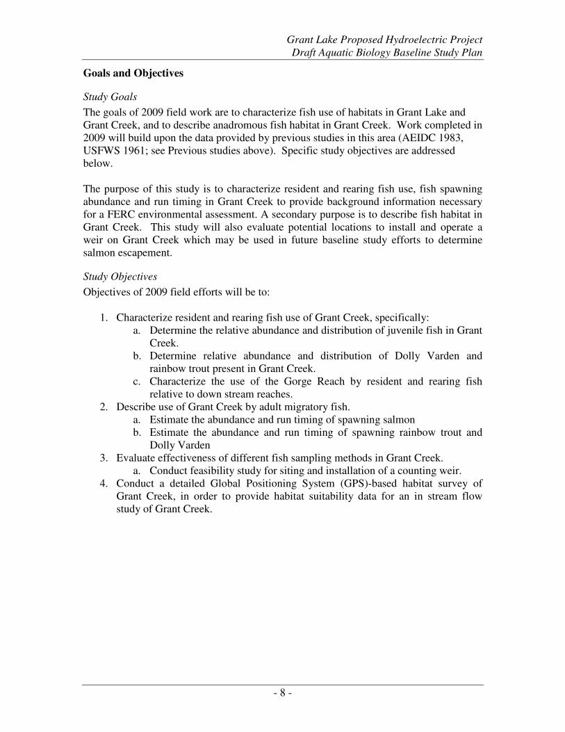
Goals and Objectives ..................................................................................................- 8 -
Study Goals .............................................................................................................- 8 -
Study Objectives......................................................................................................- 8 -
Study Design...............................................................................................................- 9 -
Sampling Approach – Grant Creek.........................................................................- 9 -
Resident and Rearing Fish Use of Grant Creek ...................................................- 10 -
Use of Grant Creek by Adult Migratory Fish .......................................................- 11 -
Habitat Mapping of Grant Creek..........................................................................- 13 -
Quality Control .........................................................................................................- 16 -
Data Analysis ............................................................................................................- 16 -
Resident and Rearing Fish Use of Grant Creek ...................................................- 16 -
Use of Grant Creek by Adult Migratory Fish .......................................................- 16 -
Habitat Mapping of Grant Creek..........................................................................- 17 -
Personnel and Responsibilities .................................................................................- 17 -
Schedule....................................................................................................................- 17 -
Fish Resources of Grant Lake.......................................................................................- 18 -
Introduction...............................................................................................................- 18 -
Goals and Objectives ................................................................................................- 19 -
Study Goals ...........................................................................................................- 19 -
Objectives..............................................................................................................- 19 -
Study Design.............................................................................................................- 19 -
Quality Control .........................................................................................................- 20 -
Data Analysis ............................................................................................................- 21 -
Instream Flow Study.....................................................................................................- 21 -
Goals and Objectives ................................................................................................- 21 -
Study Objectives....................................................................................................- 21 -
Study Design.............................................................................................................- 22 -
Study Planning ..........................................................................................................- 22 -
Study Implementation...............................................................................................- 24 -
Continuous stage/discharge stations ....................................................................- 25 -
Instantaneous stage/discharge stations ................................................................- 26 -
Analysis.....................................................................................................................- 26 -
Problem Resolution...................................................................................................- 26 -
Quality Control .........................................................................................................- 27 -
Schedule....................................................................................................................- 27 -
Work Plan Development .......................................................................................- 27 -
Grant Lake Proposed Hydroelectric Project
Draft Aquatic Biology Baseline Study Plan
- 2 -
Quality Control .............................................................................................................- 27 -
QC Level 1 Field QC ................................................................................................- 28 -
QC Level 2 Line by Line Review.............................................................................- 28 -
QC Level 3 Data Anomalies .....................................................................................- 28 -
References.....................................................................................................................- 29 -
Tables
Table 1. Adult salmonid migration blockage criteria (ADNR 2007). .........................- 14 -
Table 2. Macro- and mesohabitat units (USFS 2001)..................................................- 14 -
Table 3. Substrate size classification. ..........................................................................- 15 -
Table 4. Riparian vegetation classification (USFS 2001)............................................- 15 -
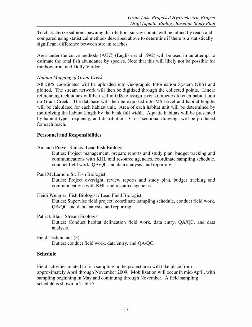
Table 5. Fish sampling activities schedule at Grant Creek, 2009................................- 18 -
Table 6. Reporting schedule for fish studies at Grant Lake and Creek, 2009. ............- 18 -
Figures
Figure 1. General location of proposed hydroelectric facilities at Grant Lake on the
Kenai Peninsula, Alaska .....................................................................................- 3 -
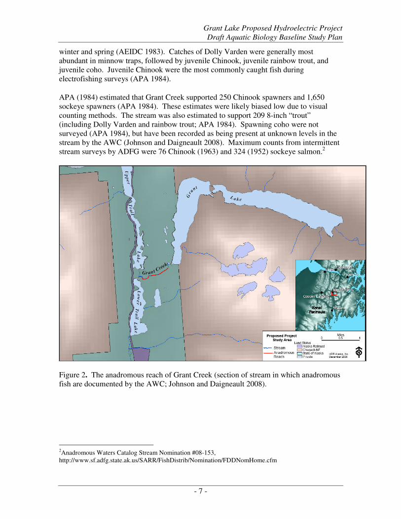
Figure 2. The anadromous reach of Grant Creek (section of stream in which anadromous
fish are documented by the AWC; Johnson and Daigneault 2008). ...................- 7 -
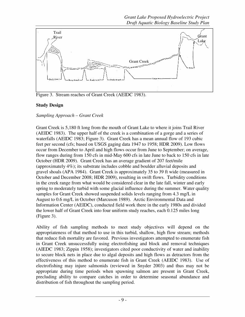
Figure 3. Stream reaches of Grant Creek (AEIDC 1983). .............................................- 9 -
Figure 4. Sampling sites at Grant Lake (AEIDC 1983)...............................................- 20 -
Grant Lake Proposed Hydroelectric Project
Draft Aquatic Biology Baseline Study Plan
- 3 -
Grant Lake and Falls Creek Proposed Hydroelectric Projects
Aquatic Biology Baseline Draft Study Plan, 2009
Introduction
Kenai Hydro LLC contracted with HDR Alaska, Inc. to provide baseline data to support
Federal Energy Regulatory Commission (FERC) license applications for a proposed
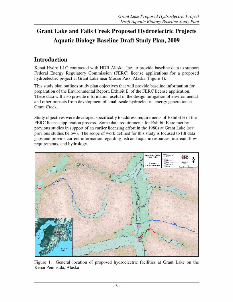
hydroelectric project at Grant Lake near Moose Pass, Alaska (Figure 1).
This study plan outlines study plan objectives that will provide baseline information for
preparation of the Environmental Report, Exhibit E, of the FERC license application.
These data will also provide information useful in the design mitigation of environmental
and other impacts from development of small-scale hydroelectric energy generation at
Grant Creek.
Study objectives were developed specifically to address requirements of Exhibit E of the
FERC license application process. Some data requirements for Exhibit E are met by
previous studies in support of an earlier licensing effort in the 1980s at Grant Lake (see
previous studies below). The scope of work defined for this study is focused to fill data
gaps and provide current information regarding fish and aquatic resources, instream flow
requirements, and hydrology.
Figure 1. General location of proposed hydroelectric facilities at Grant Lake on the
Kenai Peninsula, Alaska
Grant Lake Proposed Hydroelectric Project
Draft Aquatic Biology Baseline Study Plan
- 4 -
Project History The hydroelectric potential at Grant Lake (Figure 1) has been evaluated several times as a
potential power source for the Seward/Kenai Peninsula area. In 1954, R.W. Beck and
Associates (cited by APA 1984) prepared a preliminary investigation and concluded that
a project was feasible. The U.S. Geological Survey (USGS) conducted geologic
investigations of proposed power sites at Cooper, Grant, Ptarmigan, and Crescent Lakes
in the 1950s (Plafker 1955). In 1980 CH2M Hill (cited by APA, 1984) prepared a pre-
feasibility study for a Grant Lake project and concluded that a project developed at the
site would be feasible. The Grant Lake Project was referenced in the 1981 U.S. Army
Corps of Engineers (USACE) National Hydroelectric Power Resources Study (USACE
1981). The most extensive study was performed by Ebasco Services, Inc. in 1984 for the
Alaska Power Authority (now Alaska Energy Authority; APA 1984). Two of the
alternatives evaluated by Ebasco included the diversion of adjacent Falls Creek into
Grant Lake to provide additional water for power generation. This report relies on the
Ebasco report for the basis of the current technical conclusions with regard to hydrology,
geotechnical, and environmental considerations.
The Alaska Power Authority (APA) and Ebasco conducted detailed environmental
studies of water use and quality; aquatic, botanical and wildlife resources; historical and
archaeological resources; socioeconomic impacts; geological and soil resources;
recreational resources; aesthetic resources; and land use (APA 1984). The primary
environmental impact of Ebasco’s preferred project would have been the complete
dewatering and subsequent loss of all fish habitat in Grant Creek (natural outflow from
Grant Lake; APA 1984). Under this alternative, Grant Creek would have been
completely dewatered except for localized run-off and high flow events resulting in spill
from the reservoir (APA 1984).
Ebasco (APA 1984) compiled a detailed feasibility report on the Grant Lake
hydroelectric project, including environmental issues. The Arctic Environmental Data
Center (AEIDC 1983) and USFWS (1961) conducted environmental baseline studies in
the project area.
Project Area
The project is located near the community of Moose Pass, Alaska (pop. 206),
approximately 25 miles north of Seward, Alaska (pop. 3,016), just east of the Seward
Highway (State Route 9); this highway connects Anchorage (pop. 279,671) to Seward.
The Alaska Railroad parallels the route of the Seward Highway, and is also adjacent to
the project area. The town of Cooper Landing is located 24 miles to the northwest and is
accessible via the Sterling Highway (State Route 1) which connects to the Seward
Highway approximately 10 miles northwest of Moose Pass.
Grant Lake is located approximately 1.5 miles southeast from Moose Pass. It is located
at an elevation of approximately 696 ft above mean sea level (MSL), with a maximum
depth of nearly 300 ft and surface area of 2.6 square miles (APA 1984). Grant Lake’s
total drainage area is approximately 44 square miles. Tributaries include Inlet Creek at
the headwaters and other glacial-fed streams in the watershed. Grant Lake consists of an
upper and lower portion separated by a natural constriction and island near the midpoint.
Grant Lake Proposed Hydroelectric Project
Draft Aquatic Biology Baseline Study Plan
- 5 -
The lake is ringed by mountains of the Kenai Mountain Range to the east, north, and
south, with elevations ranging from 4, 500 to 5,500 ft.
Grant Lake’s only outlet, Grant Creek, runs west approximately 1 mile from the south
end of Grant Lake to drain into the narrows between Upper and Lower Trail Lake. Trail
River drains Lower Trail Lake, and then flows into Kenai Lake. Kenai Lake drains to the
Kenai River at its west end near Cooper Landing (APA 1984). Grant Creek has a mean
annual flow of 193 cubic feet per second (cfs), is 5,180 ft long, with an average gradient
of 207 ft/mi; its substrate includes cobble and boulder alluvial deposits and gravel shoals
(APA 1984). The stream is 25 ft wide on average. In its upper half, the stream passes
through a rocky gorge with three substantial waterfalls; in its lower half, the stream
becomes less turbulent as it passes over gravel shoals and diminishing boulder substrate
(APA 1984).
Falls Creek is located approximately two miles south of the south end of Grant Lake; it
flows into Trail River just downstream of Lower Trail Lake (approximately 1.8 miles
downstream of Grant Creek). The Falls Creek watershed drains steep terrain between the
Grant Lake and Ptarmigan Lake watersheds, is 11.9 square miles in area, contains no
lakes, and has no major tributaries. Estimated mean annual flow of Falls Creek is 38 cfs;
stream flow during the winter is minimal. Falls Creek is 42,240 ft (approx. 8 miles) long,
average stream gradient is 418 ft/mi and stream width averages 15 ft wide. Substrate
composition for Falls Creek includes cobble, boulder deposits, few gravel bars and a thin
layer of fine silt near the mouth; the lower one mile of stream has been extensively
channelized and modified by placer mining (APA 1984). Three to four acres adjacent to
the active channel in the lower 0.5 miles are covered with tailings and 100 yards of the
streambed in this area has been relocated (AEIDC 1983).
Fish Resources of Grant Creek
Introduction
Grant Lake and Grant Creek support different assemblages of fish species and possess
varying quality and quantity of fish habitat. Only non-anadromous fish have been found
in Grant Lake (AEIDC 1983, USFWS 1961, Johnson and Daigneault 2008), whereas
anadromous fish are present in Grant Creek (Figure 2). The following sections describe
proposed baseline studies of fish resources.
Grant Lake supports resident populations of sculpin (Cottidae) and threespine stickleback
(Gasterosteus aculeatus), but salmon were not caught in Grant Lake or any of its
tributaries during environmental assessments (USFWS 1961; AEIDC 1983; APA 1984);
it is not included in the Anadromous Waters Catalog (AWC) published by Alaska
Department of Fish and Game (ADF&G; Johnson and Daigneault 2008). Grant Creek is
included in the AWC due to the presence of spawning Chinook, sockeye and coho
salmon and rearing coho salmon (Johnson and Daigneault 2008).
Grant Lake Proposed Hydroelectric Project
Draft Aquatic Biology Baseline Study Plan
- 6 -
Previous Studies
Previous licensing efforts in the 1960s and 1980s for proposed hydroelectric projects at
Grant Lake included studies of fish resources in Grant Lake and Grant Creek. AIEDC
(1983) conducted fish sampling from 1981 to 1982 as part of comprehensive
environmental baseline studies and USFWS (1961) conducted limited sampling from
1959 to 1960.
Grant Lake Fish Resources
A 1981-1982 sampling program found no fish in any of the tributaries of Grant Lake
(AEIDC 1983). Sculpin and threespine stickleback were the only fish found to inhabit
Grant Lake. A series of impassable falls1 near Grant Lake’s outlet prevents colonization
of the lake by salmonids via Grant Creek (APA 1984). Grant Lake supports a “small”
population of slimy sculpin (Cottus cognatus) and a “dense” population of threespine
stickleback (USFWS 1961). Density of threespine stickleback was ten times higher in
the lower basin than the upper basin of Grant Lake (AEIDC 1983). A weir was operated
at Grant Creek from 1985 to 1988 in order to obtain total counts of returning hatchery
coho (1.9 million) released into Grant Lake from 1983 to 1986.
Grant Creek Fish Resources
Both anadromous and resident fish are present in Grant Creek, including salmon, trout
and other fish. Spawning Chinook (Oncorhynchus tshawytscha), sockeye (Oncorhynchus
nerka), and coho salmon (Oncorhynchus kisutch), as well as rainbow trout
(Oncorhynchus mykiss) and Dolly Varden are found in the lower reaches of Grant Creek
(APA 1984; Johnson and Daigneault 2008; Figure 2). Rearing Chinook, coho and
rainbow trout are also present (APA 1984, Johnson and Daigneault 2008). Round
whitefish (Prosopium cylindraceum) and Arctic grayling (Thymallus arcticus) were
caught during angling surveys, but not assumed to spawn in Grant Creek (APA 1984).
Upper Grant Creek is impassable to salmon one half (APA 1984) to one mile (Johnson
and Daigneault 2008) upstream of the mouth; fish habitat is most likely concentrated
within the lower portion of stream. Habitat for juvenile fish exists mainly in stream
margins, eddies, deep pools and side channels offering reduced velocities (APA 1984).
Substrate material is coarse throughout the entire length of the creek due to high water
velocity, which tends to wash away smaller gravels (APA 1984). Isolated areas of
suitable spawning gravels occur in the lower half of the stream (APA 1984).
Periodic minnow trapping on Grant Creek from July 1959 through January 1961 captured
Chinook salmon, coho salmon, Dolly Varden and sculpin (extent of sampling area
unknown; USFWS 1961). Minnow trapping and electrofishing in lower reaches of Grant
Creek for week-long periods in October 1981 and March, May, June, and August 1982
yielded higher catches of trout, salmon and Dolly Varden in the fall and summer than in
1 2007 ADFG Stream survey referenced in Anadromous Waters Catalog Stream Nomination #08-153,
http://www.sf.adfg.state.ak.us/SARR/FishDistrib/Nomination/FDDNomHome.cfm
Grant Lake Proposed Hydroelectric Project
Draft Aquatic Biology Baseline Study Plan
- 7 -
winter and spring (AEIDC 1983). Catches of Dolly Varden were generally most
abundant in minnow traps, followed by juvenile Chinook, juvenile rainbow trout, and
juvenile coho. Juvenile Chinook were the most commonly caught fish during
electrofishing surveys (APA 1984).
APA (1984) estimated that Grant Creek supported 250 Chinook spawners and 1,650
sockeye spawners (APA 1984). These estimates were likely biased low due to visual
counting methods. The stream was also estimated to support 209 8-inch “trout”
(including Dolly Varden and rainbow trout; APA 1984). Spawning coho were not
surveyed (APA 1984), but have been recorded as being present at unknown levels in the
stream by the AWC (Johnson and Daigneault 2008). Maximum counts from intermittent
stream surveys by ADFG were 76 Chinook (1963) and 324 (1952) sockeye salmon.2
Figure 2. The anadromous reach of Grant Creek (section of stream in which anadromous
fish are documented by the AWC; Johnson and Daigneault 2008).
2Anadromous Waters Catalog Stream Nomination #08-153,
http://www.sf.adfg.state.ak.us/SARR/FishDistrib/Nomination/FDDNomHome.cfm
Grant Lake Proposed Hydroelectric Project
Draft Aquatic Biology Baseline Study Plan
- 8 -
Goals and Objectives
Study Goals
The goals of 2009 field work are to characterize fish use of habitats in Grant Lake and
Grant Creek, and to describe anadromous fish habitat in Grant Creek. Work completed in
2009 will build upon the data provided by previous studies in this area (AEIDC 1983,
USFWS 1961; see Previous studies above). Specific study objectives are addressed
below.
The purpose of this study is to characterize resident and rearing fish use, fish spawning
abundance and run timing in Grant Creek to provide background information necessary
for a FERC environmental assessment. A secondary purpose is to describe fish habitat in
Grant Creek. This study will also evaluate potential locations to install and operate a
weir on Grant Creek which may be used in future baseline study efforts to determine
salmon escapement.
Study Objectives
Objectives of 2009 field efforts will be to:
1. Characterize resident and rearing fish use of Grant Creek, specifically:
a. Determine the relative abundance and distribution of juvenile fish in Grant
Creek.
b. Determine relative abundance and distribution of Dolly Varden and
rainbow trout present in Grant Creek.
c. Characterize the use of the Gorge Reach by resident and rearing fish
relative to down stream reaches.
2. Describe use of Grant Creek by adult migratory fish.
a. Estimate the abundance and run timing of spawning salmon
b. Estimate the abundance and run timing of spawning rainbow trout and
Dolly Varden
3. Evaluate effectiveness of different fish sampling methods in Grant Creek.
a. Conduct feasibility study for siting and installation of a counting weir.
4. Conduct a detailed Global Positioning System (GPS)-based habitat survey of
Grant Creek, in order to provide habitat suitability data for an in stream flow
study of Grant Creek.
Grant Lake Proposed Hydroelectric Project
Draft Aquatic Biology Baseline Study Plan
- 9 -
Figure 3. Stream reaches of Grant Creek (AEIDC 1983).
Study Design
Sampling Approach – Grant Creek
Grant Creek is 5,180 ft long from the mouth of Grant Lake to where it joins Trail River
(AEIDC 1983). The upper half of the creek is a combination of a gorge and a series of
waterfalls (AEIDC 1983; Figure 3). Grant Creek has a mean annual flow of 193 cubic
feet per second (cfs; based on USGS gaging data 1947 to 1958; HDR 2009). Low flows
occur from December to April and high flows occur from June to September; on average,
flow ranges during from 150 cfs in mid-May 600 cfs in late June to back to 150 cfs in late
October (HDR 2009). Grant Creek has an average gradient of 207 feet/mile
(approximately 4%); its substrate includes cobble and boulder alluvial deposits and
gravel shoals (APA 1984). Grant Creek is approximately 35 to 39 ft wide (measured in
October and December 2008; HDR 2009), resulting in swift flows. Turbidity conditions
in the creek range from what would be considered clear in the late fall, winter and early
spring to moderately turbid with some glacial influence during the summer. Water quality
samples for Grant Creek showed suspended solids levels ranging from 4.3 mg/L in
August to 0.6 mg/L in October (Marcuson 1989). Arctic Environmental Data and
Information Center (AEIDC), conducted field work there in the early 1980s and divided
the lower half of Grant Creek into four uniform study reaches, each 0.125 miles long
(Figure 3).
Ability of fish sampling methods to meet study objectives will depend on the
appropriateness of that method to use in this turbid, shallow, high flow stream; methods
that reduce fish mortality are favored. Previous investigators attempted to enumerate fish
in Grant Creek unsuccessfully using electrofishing and block and removal techniques
(AIEDC 1983; Zippin 1958); investigators cited poor conductivity of water and inability
to secure block nets in place due to algal deposits and high flows as detractors from the
effectiveness of this method to enumerate fish in Grant Creek (AEIDC 1983). Use of
electrofishing may injure salmonids (reviewed in Snyder 2003) and thus may not be
appropriate during time periods when spawning salmon are present in Grant Creek,
precluding ability to compare catches in order to determine seasonal abundance and
distribution of fish throughout the sampling period.
Grant Creek
Grant
Lake
Trail
River
Grant Lake Proposed Hydroelectric Project
Draft Aquatic Biology Baseline Study Plan
- 10 -
Resident and rearing fish under 200 mm in length have been sampled successfully with
minnow traps in Grant Creek (AEIDC 1983, USFWS 1961), so repetition of this method
is appropriate and results will be comparable to these earlier data. Hoop traps and
angling surveys may be an effective method of sampling migratory salmonids larger than
200 mm (i.e. adult Dolly Varden and rainbow trout; Bartlett and Hansen 2000, Larson
1998, Bradley 1990), but use of hoop traps is precluded by high flows. Effectiveness of
angling and visual count methods of enumerating adult fish will be assessed and
compared in 2009.
Beach seining, visual counts, and total counts may be effective methods for evaluating
adult migratory fish use of Grant Creek. However, substrate size and stream size would
likely preclude beach seining as an effective technique for sampling fish in Grant Creek;
the stream cannot safely be waded during all seasons and is too shallow to set nets using
a boat. Turbidity may also limit accuracy of visual counts of adult salmonids (Hagen and
Baxter 2005).
From 1985 through 1988 Cook Inlet Aquaculture Association (CIAA) monitored salmon
escapement in Grant Creek using an aluminum picket weir spanning the entire width of
the stream (Marcuson 1989). Given the stream conditions described above and the
apparent success associated with CIAA efforts, a weir would likely be the most effective
approach to enumerating salmon and resident fish species in Grant Creek.
Cost and logistics preclude operation of a weir at Grant Creek in 2009, but feasibility of
this sampling method for use in the future will be evaluated in 2009. A reasonable
approach for the 2009 field season would be to conduct foot and angling surveys to
provide an initial indication of distribution and abundance. Both angling and foot surveys
would be conducted for rainbow trout and Dolly Varden with only foot surveys used for
adult salmon.
Resident and Rearing Fish Use of Grant Creek
HDR biologists will reestablish reaches identified by AEIDC (1983; Figure 3) and
sample them for juvenile anadromous and resident fish. Target species will include
Chinook and coho salmon, Dolly Varden, rainbow trout, and sculpin. Each reach will be
uniformly sampled using baited ¼ inch mesh minnow traps to determine catch per unit
effort (CPUE). CPUE can be defined as the catch per trap hour.
Minnow traps will be set for a uniform amount of time within each reach, presumably 24
hours. Reaches 1-4 and the Gorge Reach will receive uniform sampling efforts based on
the length of each reach. Approximately 10 traps will be set in Reaches 1-4 and
approximately 30 traps will be placed in the Gorge Reach. Due to the geomorphology of
the Gorge Reach, setting 30 traps may not be feasible; however, effort will be made to set
as many as possible. The Falls Reach will be sampled opportunistically; since it is a
series of waterfalls, it will most likely not be feasible to set minnow traps uniformly
Grant Lake Proposed Hydroelectric Project
Draft Aquatic Biology Baseline Study Plan
- 11 -
throughout the reach. Effort will be made to sample the outlet of Grant Lake (see below
Fish Use of Grant Lake).
All sampling sites will be marked by a GPS, staked, and flagged for future identification.
Habitat characteristics will also be recorded. Once minnow trapping is complete, effort
will be made to electrofish the area around which the traps were placed to confirm
minnow trapping results and to collect species that may not recruit to the traps. The
electrofishing will occur after the minnow trapping so that it will not interfere with the
trap catch. Fish captured in the minnow traps will be retained during the electrofishing
effort, so as to not recapture them. Each site will be electrofished for a standard amount
of time. All reaches will be minnow trapped bimonthly from May through October.
Angling surveys will be used to characterize the use of Grant Creek by rainbow trout and
Dolly Varden throughout the open water season. Angling surveys will be conducted at
least one day after foot surveys for adult migratory fish have occurred (see study section
below, Use of Grant Creek by Adult Migratory Fish). This effort will provide
information on seasonal distribution of species.
Fish captured will be identified to species level, and released near the point of capture. A
target sample of fish will be sampled for length to the nearest millimeter (n=30 per
sampling event and species); salmonids will be sampled for fork length or tip of the snout
to the fork in the tail, and other fish will be sampled for total length or tip of snout to end
of tail. As the distance from the outlet increases, CPUE is expected to decrease in Grant
Creek.
Use of Grant Creek by Adult Migratory Fish
Angling Surveys
Spawning rainbow trout and Dolly Varden would be counted using a combination of
methods. Grant Creek would be divided into the six reaches as previously identified by
AEIDC in 1983.
Angling stations will be established within each stream reach, with each reach containing
the same number of stations per river mile so that the level of effort between reaches is
uniform. Angling stations would be identified in the field, flagged, and marked using
GPS coordinates so that each station can be relocated. It is important to note that these
angling stations will likely be the same as those identified in the Resident Fish Study.
After completing the foot survey, field crew members will begin conducting angling
surveys. Each angling station will be fished for 30 minutes, using rod and reel methods in
accordance with ADF&G Sport Fishing Regulations.
Angling surveys for rainbow trout will be timed to coincide with the probable spawning
time which occurs after breakup in late spring. Trout spawning normally begins after
water temperatures warm to about 4°C. Grant Creek water temperatures will be
monitored after ice-out to determine when surveys should be initiated.
Grant Lake Proposed Hydroelectric Project
Draft Aquatic Biology Baseline Study Plan
- 12 -
All fish captured will be immediately landed and netted. Each fish will be measured,
sexed (if possible), and its spawning condition described. After being captured each fish
will be walked down stream and released in a slow water area away from the angling
station.
In the event that foot and/or angling survey methods do not appear to be effective
especially for Dolly Varden, field crews will conduct snorkel surveys in deep pools to
determine the presence or absence of spawning fish. While it is recognized that this
method would not provide a statistical estimate of abundance, it would however provide
useful presence and absence information that future baseline studies could build upon.
Foot Surveys
Foot surveys will be conduced to estimate the abundance of spawning fish in Grant
Creek. Two survey crews, made up of two members each, will begin at the downstream
terminus of each stream reach. One survey crew on each stream bank will visually count
fish as they move upstream. All fish tallied will be identified to species. The survey area
will include all active channels including side channels and back water pool areas.
To avoid double counting each crew will attempt to count fish from the middle of the
stream to the shore. Salmon that are obviously spawned out but still swimming (i.e. a live
carcass) will be counted as a carcass rather than a live fish.
The number of fish counted within each stream reach will be tallied and GPS coordinates
will be recorded at the end of each survey reach. Other data such as the number of active
redds, areas of concentrated spawning activity, number of carcasses and survey
conditions will also be recorded using GPS.
Weir Site Reconnaissance
Two or three locations near the mouth of the creek will be selected and assessed for the
possible installation of a weir. An attempt will be made to find the weir location operated
by CIAA in the 1980s. The following information will be recorded for each possible weir
location:
• Channel geometry
• Bed width
• Wet width at low and high flow conditions
• Stream bank conditions – stability, erosional features, undercut bank, vegetation
• Substrate
• Thalweg velocity measurements at low and high flow conditions
• Fish use of the area – bank orientation, holding or moving upstream, active
spawning, overall abundance; and
• Photographs
In addition to the information above, the use of different weir types and enumeration
techniques will be evaluated such as of a resistance board weir or time laps videography.
Grant Lake Proposed Hydroelectric Project
Draft Aquatic Biology Baseline Study Plan
- 13 -
This information will be used to draft a technical memorandum that will provide
recommendations for the possible installation and operation of a weir.
Habitat Mapping of Grant Creek
Aquatic habitat within Grant Creek has not been well characterized. An aquatic habitat
distribution survey will describe the existing instream conditions and will provide a
baseline against which future conditions can be compared. A detailed, GPS-based,
habitat survey will be conducted to quantify the aquatic habitat of Grant Creek. Habitat
delineation will be based on the protocol outlined in U.S. Forest Service FSH 2090-
Aquatic Habitat Management Handbook, which establishes standard techniques for
conducting fish and aquatic stream habitat surveys in coastal Alaska (USFS 2001).
Detailed methods are described in detail in USFS 2001. A modified Tier Three approach
(USFS 2001) will be used.
Habitat surveys will be conducted by walking upstream from the mouth of Grant Creek to
the outlet of Grant Lake. Linear stream reference points will be based on the upstream
and downstream GPS coordinates of each habitat unit as well as correlated with
photographs of representative habitat units. Photographs will be taken at the upstream
end of the habitat unit, looking downstream. A subset of photographs will be reviewed to
verify the habitat unit was classified correctly. Geo-referenced video of the creek will
also be recorded at strategic locations at different flows to help document baseline habitat
conditions.
Data will be recorded on a handheld personal computer with internal GPS. Channel bed
width measurements, maximum habitat unit depth, dominant substrate, amount of large
woody debris, and amount of undercut bank will be determined for all habitat units.
Investigators will record riparian vegetation, tributary confluence location, surface water
temperature, stream gradient, and USFS channel type (USFS 1992) as well as Rosgen
channel type to the alpha level (Rosgen 1996). Blockages to adult anadromous salmonid
migration (ADNR 2007) will also be measured. All existing structures observed in Grant
Creek such as buildings, bridges, and culverts will be documented and photographs
taken. Pebble counts and discharge measurements will be conducted for each reach
(USFS 2001). Investigators will use data collected to produce cross sections of the
stream for each reach (see Data Analysis below).
Side channels will be surveyed to the same tier as the adjacent main channel. The
presence of a side channel will be identified based on the size of the island between each
side channel at bank full flows using the following rule: a side channel is denoted if the
island between the side channel and the main channel is at least as long as the creek is
wide at bank full flow (USFS 2001).
The USFS and Alaska Department of Natural Resources (ADNR) defines blockages to
adult salmon migration using specific criteria for each species of Pacific salmon, such as
maximum fall height, pool depth, and channel gradient (USFS2001; ADNR 2007).
ADNR criteria are similar to the USFS criteria; however, it differs regarding channel
gradient. Since the USFS criteria have been developed for coastal regions in Alaska, and
Grant Lake Proposed Hydroelectric Project
Draft Aquatic Biology Baseline Study Plan
- 14 -
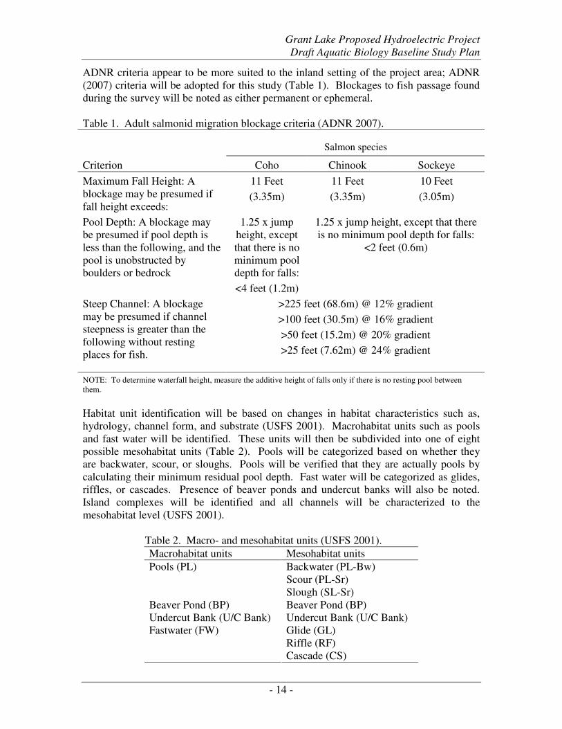
ADNR criteria appear to be more suited to the inland setting of the project area; ADNR
(2007) criteria will be adopted for this study (Table 1). Blockages to fish passage found
during the survey will be noted as either permanent or ephemeral.
Table 1. Adult salmonid migration blockage criteria (ADNR 2007).
Salmon species
Criterion Coho Chinook Sockeye
Maximum Fall Height: A
blockage may be presumed if
fall height exceeds:
11 Feet
(3.35m)
11 Feet
(3.35m)
10 Feet
(3.05m)
Pool Depth: A blockage may
be presumed if pool depth is
less than the following, and the
pool is unobstructed by
boulders or bedrock
1.25 x jump
height, except
that there is no
minimum pool
depth for falls:
<4 feet (1.2m)
1.25 x jump height, except that there
is no minimum pool depth for falls:
<2 feet (0.6m)
Steep Channel: A blockage
may be presumed if channel
steepness is greater than the
following without resting
places for fish.
>225 feet (68.6m) @ 12% gradient
>100 feet (30.5m) @ 16% gradient
>50 feet (15.2m) @ 20% gradient
>25 feet (7.62m) @ 24% gradient
NOTE: To determine waterfall height, measure the additive height of falls only if there is no resting pool between
them.
Habitat unit identification will be based on changes in habitat characteristics such as,
hydrology, channel form, and substrate (USFS 2001). Macrohabitat units such as pools
and fast water will be identified. These units will then be subdivided into one of eight
possible mesohabitat units (Table 2). Pools will be categorized based on whether they
are backwater, scour, or sloughs. Pools will be verified that they are actually pools by
calculating their minimum residual pool depth. Fast water will be categorized as glides,
riffles, or cascades. Presence of beaver ponds and undercut banks will also be noted.
Island complexes will be identified and all channels will be characterized to the
mesohabitat level (USFS 2001).
Table 2. Macro- and mesohabitat units (USFS 2001).
Macrohabitat units Mesohabitat units
Backwater (PL-Bw)
Scour (PL-Sr)
Pools (PL)
Slough (SL-Sr)
Beaver Pond (BP) Beaver Pond (BP)
Undercut Bank (U/C Bank) Undercut Bank (U/C Bank)
Glide (GL)
Riffle (RF)
Fastwater (FW)
Cascade (CS)
Grant Lake Proposed Hydroelectric Project
Draft Aquatic Biology Baseline Study Plan
- 15 -
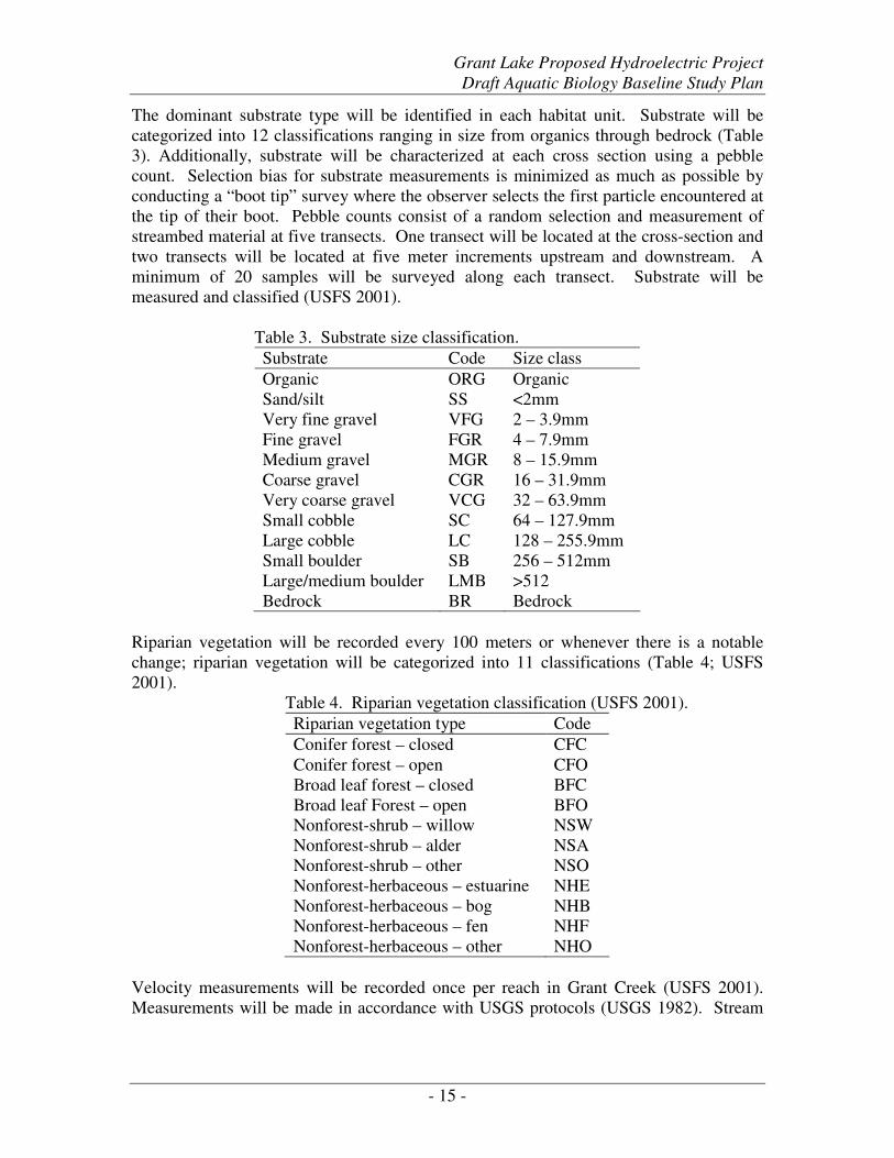
The dominant substrate type will be identified in each habitat unit. Substrate will be
categorized into 12 classifications ranging in size from organics through bedrock (Table
3). Additionally, substrate will be characterized at each cross section using a pebble
count. Selection bias for substrate measurements is minimized as much as possible by
conducting a “boot tip” survey where the observer selects the first particle encountered at
the tip of their boot. Pebble counts consist of a random selection and measurement of
streambed material at five transects. One transect will be located at the cross-section and
two transects will be located at five meter increments upstream and downstream. A
minimum of 20 samples will be surveyed along each transect. Substrate will be
measured and classified (USFS 2001).
Table 3. Substrate size classification.
Substrate Code Size class
Organic ORG Organic
Sand/silt SS <2mm
Very fine gravel VFG 2 – 3.9mm
Fine gravel FGR 4 – 7.9mm
Medium gravel MGR 8 – 15.9mm
Coarse gravel CGR 16 – 31.9mm
Very coarse gravel VCG 32 – 63.9mm
Small cobble SC 64 – 127.9mm
Large cobble LC 128 – 255.9mm
Small boulder SB 256 – 512mm
Large/medium boulder LMB >512
Bedrock BR Bedrock
Riparian vegetation will be recorded every 100 meters or whenever there is a notable
change; riparian vegetation will be categorized into 11 classifications (Table 4; USFS
2001).
Table 4. Riparian vegetation classification (USFS 2001).
Riparian vegetation type Code
Conifer forest – closed CFC
Conifer forest – open CFO
Broad leaf forest – closed BFC
Broad leaf Forest – open BFO
Nonforest-shrub – willow NSW
Nonforest-shrub – alder NSA
Nonforest-shrub – other NSO
Nonforest-herbaceous – estuarine NHE
Nonforest-herbaceous – bog NHB
Nonforest-herbaceous – fen NHF
Nonforest-herbaceous – other NHO
Velocity measurements will be recorded once per reach in Grant Creek (USFS 2001).
Measurements will be made in accordance with USGS protocols (USGS 1982). Stream
Grant Lake Proposed Hydroelectric Project
Draft Aquatic Biology Baseline Study Plan
- 16 -
gradient and surface water temperature will be measured eight times daily and/or at every
10th
habitat unit (USFS 2001).
Quality Control
See Quality Control section of study plan.
Data Analysis
Resident and Rearing Fish Use of Grant Creek
CPUE will be determined by dividing the catch (number of fish caught) by the effort
(fishing time). CPUE will be determined for each species in each reach and gear type
(e.g. minnow trap, hoop trap, hook and line) and a total CPUE for each reach. It will then
be compared between reaches to determine the greatest relative abundance for each
species.
Due to small sample sizes and the likelihood that the data will not be normally
distributed, Kruskall-Wallis test (a nonparametric ANOVA) will be used to determine if
there are statistically significant differences in CPUE between reaches. If a significant
result arises, Mann Whitney U tests will then be used to determine which reaches are
significantly different from each other. If there are statistically significant differences
between reaches, then those reaches contain differing CPUE and thus differing numbers
of fish.
Relative abundance will be determined by species for each reach. Relative abundance
values between reaches will also be compared statistically using similar methods as
described above. Length frequency distribution graphs will be produced for each species
to determine age classes present in each reach.
Use of Grant Creek by Adult Migratory Fish
Catch per unit of effort (CPUE) will be determined by dividing the catch by the effort of
fishing time (i.e. catch per hour). CPUE will be determined for rainbow trout and Dolly
Varden in each reach. It will then be compared between reaches to determine the greatest
relative abundance for each species.
It is likely the sample sizes will be small and the data will not be normally distributed;
therefore, the Kruskall-Wallis test (a nonparametric ANOVA) will be used to determine
if there are statistically significant differences in CPUE between reaches. If a significant
result arises, Mann Whitney U tests will then be used to determine which reaches are
significantly different from each other. Statistically significant differences between
reaches would indicate reaches contain differing CPUE and thus differing numbers of
fish.
Run duration timing will be characterized by comparing the number of fish captured per
sampling day over the total number of angling effort days. Length frequency distribution
graphs will be produced for each species to estimate age classes present in each reach.
Grant Lake Proposed Hydroelectric Project
Draft Aquatic Biology Baseline Study Plan
- 17 -
To characterize salmon spawning distribution, survey counts will be tallied by reach and
compared using statistical methods described above to determine if there is a statistically
significant difference between stream reaches.
Area under the curve methods (AUC) (English et al 1992) will be used in an attempt to
estimate the total fish abundance by species. Note that this will likely not be possible for
rainbow trout and Dolly Varden.
Habitat Mapping of Grant Creek
All GPS coordinates will be uploaded into Geographic Information System (GIS) and
plotted. The stream network will then be digitized through the collected points. Linear
referencing techniques will be used in GIS to assign river kilometers to each habitat unit
on Grant Creek. The database will then be exported into MS Excel and habitat lengths
will be calculated for each habitat unit. Area of each habitat unit will be determined by
multiplying the habitat length by the bank full width. Aquatic habitats will be presented
by habitat type, frequency, and distribution. Cross sectional drawings will be produced
for each reach.
Personnel and Responsibilities
Amanda Prevel-Ramos: Lead Fish Biologist
Duties: Project management, prepare reports and study plan, budget tracking and
communications with KHL and resource agencies, coordinate sampling schedule,
conduct field work, QA/QC and data analysis, and reporting.
Paul McLarnon: Sr. Fish Biologist
Duties: Project oversight, review reports and study plan, budget tracking and
communications with KHL and resource agencies
Heidi Weigner: Fish Biologist / Lead Field Biologist
Duties: Supervise field project, coordinate sampling schedule, conduct field work,
QA/QC and data analysis, and reporting.
Patrick Blair: Stream Ecologist
Duties: Conduct habitat delineation field work, data entry, QA/QC, and data
analysis.
Field Technicians (3)
Duties: conduct field work, data entry, and QA/QC.
Schedule
Field activities related to fish sampling in the project area will take place from
approximately April through November 2009. Mobilization will occur in mid-April, with
sampling beginning in May and continuing through November. A field sampling
schedule is shown in Table 5.
Grant Lake Proposed Hydroelectric Project
Draft Aquatic Biology Baseline Study Plan
- 18 -
Table 5. Fish sampling activities schedule at Grant Creek, 2009.
Activity Time period
Habitat sampling May
Rearing and resident fish sampling May – October
Rainbow trout spawning surveys May – June
Salmon spawning surveys June – October
Dolly Varden spawning surveys October - November
A comprehensive baseline studies report will be developed. Field methods, data
analyses, results, discussion of results and corresponding maps and figures will be
included in this report. A project deliverables schedule is shown in Table 6.
Table 6. Reporting schedule for fish studies at Grant Lake and Creek, 2009.
Deliverable Date
Final baseline study plan April 15, 2009
Draft environmental baseline studies report for 2009 field
season
December 30, 2009
Final environmental baseline studies report for 2009 field
season
January 31, 2009
Fish Resources of Grant Lake
Introduction
Grant Lake, located in the Kenai River drainage, is a 1,598 acre glacial-fed lake that is
characterized by two basins surrounded by steep mountains. The shoreline in most places
is steep, with bedrock outcroppings interspersed with gravel beaches. Both basins are
deep, extending to depths of approximately 300 feet, and appear to have relatively
uniform bottoms covered with deposits of thick clay and silt (AEIDC 1983). The two
basins are separated by a narrow isthmus with an island in the middle. Water depth is
less than 10 feet at the connection between the two basins (CIAA 1989). The shoreline is
littered with floating and sunken organic debris. Patches of thick macrophyte growth
extend from the lake bottom in the few littoral areas that are present. The water surface of
the lake appears to fluctuate moderately, likely rising to its highest elevation during the
summer runoff and falling to a low point in late winter (AEIDC 1983)
Numerous short streams originate from the steep mountains that surround much of the
lake. Additionally, three glacial streams enter the lake, as well as two moderately turbid
streams at the upper end of the upper basin (AEIDC 1983).
Sisson (1984) reported that Dolly Varden and a few rainbow trout occupy Grant Lake.
However, numerous investigations (USFWS 1961, AEIDC 1983 and CIAA 1983) have
indicated that Grant Lake currently only supports a small population of coast range
sculpin (Cottus aleuticus) and a dense population of three spine stickleback (Gasterosteus
aculeatus). AEIDC (1983) reported that no fish were found in any of the inlet streams
and no other species of fish [except sculpin and stickleback] was taken in the lake. Falls
Grant Lake Proposed Hydroelectric Project
Draft Aquatic Biology Baseline Study Plan
- 19 -
near the outlet of the lake form a fish passage barrier that prevents other fish species such
as salmon and trout from entering the lake.
During October 1983 through 1986, approximately 1.9 million juvenile coho salmon
were released into Grant Lake as part of a coho salmon enhancement program that was
run by CIAA (Marcuson 1989). The objective of the program was to provide coho
salmon to commercial, sports and personal use fisheries in Cook Inlet and the Kenai
River Drainage. The Grant Lake stocking program produced poor results with an average
survival of 0.19%. Of the 1.9 million fry stocked in Grant Lake, only 3,750 returned to
Grant Creek (Marcuson 1989) and as a result the stocking program was discontinued.
Goals and Objectives
Study Goals
The purpose of this study is to characterize fish use within Grant Lake to help assess fish
habitat value within the project area and provide background information necessary for
the FERC environmental assessment.
Objectives
• Characterize fish community composition within Grant Lake.
• Verify the results of previous fish studies in Grant Lake.
Study Design
Historical sampling efforts in Grant Lake have employed baited minnow traps and
variable mesh gill nets. The 2009 Grant Lake fish characterization baseline study will
employ these same methods and also include beach seining in the lake and electrofishing
in lake tributaries.
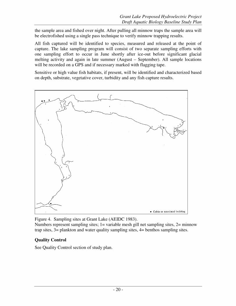
Gill nets will be deployed in approximately the same locations that were sampled in 1982
(AEIDC 1983; see Figure 4 for historic sample locations) as well as at other promising
locations. Gill nets will be set both perpendicular and parallel to shore and at a variety of
depths up to 200 feet deep. Nets will be fished for 6- to 8-hour periods and checked
frequently each day. Gill net sets may occur over night but only if it is determined that
there is a low risk of excessive fish mortality or entanglement of water fowl.
Minnow traps baited with cured salmon eggs will be fished in approximately the same
locations as shown in Figure 4 as well as at other promising locations such as areas of
habitat complexity like wood clusters and alluvial fan areas. All minnow traps will be
fished overnight for approximately 24 hours.
Where possible, several areas throughout the lake shore will also be sampled using a 50-
foot beach seine. The seine will be deployed perpendicular to shore and hauled in parallel
to shore.
Tributaries to Grant Lake will be sampled using baited minnow traps that will be fished
in approximately the same locations as shown in Figure 4. Additional areas that may
appear to support fish may also be sampled. The length of each sample area will be 25
times the width of the stream channel. Baited minnow traps will be distributed throughout
Grant Lake Proposed Hydroelectric Project
Draft Aquatic Biology Baseline Study Plan
- 20 -
the sample area and fished over night. After pulling all minnow traps the sample area will
be electrofished using a single pass technique to verify minnow trapping results.
All fish captured will be identified to species, measured and released at the point of
capture. The lake sampling program will consist of two separate sampling efforts with
one sampling effort to occur in June shortly after ice-out before significant glacial
melting activity and again in late summer (August – September). All sample locations
will be recorded on a GPS and if necessary marked with flagging tape.
Sensitive or high value fish habitats, if present, will be identified and characterized based
on depth, substrate, vegetative cover, turbidity and any fish capture results.
Figure 4. Sampling sites at Grant Lake (AEIDC 1983).
Numbers represent sampling sites; 1= variable mesh gill net sampling sites, 2= minnow
trap sites, 3= plankton and water quality sampling sites, 4= benthos sampling sites.
Quality Control
See Quality Control section of study plan.
Grant Lake Proposed Hydroelectric Project
Draft Aquatic Biology Baseline Study Plan
- 21 -
Data Analysis
Data analysis will consist of a characterization sensitive or high value fish habitats based
on CPUE, fish presence / absence documentation, a list of species captured and their
relative abundance.
Instream Flow Study
Goals and Objectives
The purpose of the instream flow study is to determine the potential effects of a range of
flow regimes on physical habitat and water temperature in Grant Creek as a means of
evaluating project operating alternatives and assessing project impacts per the
requirements of the FERC licensing process and other regulatory requirements.
Study Objectives
• Review existing documentation of fish habitat, flow, and temperature in Grant
Creek.
• Coordinate and share information with the habitat mapping, fish resources, and
water quality studies that will be conducted concurrently on Grant Creek.
• Lead the collaborative preparation of an instream flow study design with the
Instream Flow Technical Working Group (TWG).
• Conduct field data collection for instream flow.
• Locate, install, and maintain continuous and/or instantaneous flow and
temperature stations on Grant Creek.
• Analyze and model fish habitat availability as a function of TWG-selected
alternate flow regimes using existing and collected data.
• Document and report instream flow analysis and results.
• Assist Kenai Hydro LLC (KHL) in achieving a flow regime negotiated solution.
For a hydroelectric project, an instream flow study is typically an impact assessment
rather than a baseline study. The purpose is to determine the potential change in
available habitat as flow regime is changed under the conditions of the hydroelectric
facility. To determine impacts, a proposed change in the baseline condition should be
known. This means a hydroelectric facility plan should be progressed beyond a
conceptual plan to a level at which spatial and temporal impacts may be estimated.
While an instream flow study is not typically a baseline study, physical habitat data is
usually collected on the existing condition in the stream. Other baseline studies also feed
into an instream flow study, including hydrology, water quality, fish resources, and
habitat mapping.
It should be noted that the primary focus for the 2009 instream flow study program will
be the collection of baseline hydrology data and the development of a detailed work plan.
Grant Lake Proposed Hydroelectric Project
Draft Aquatic Biology Baseline Study Plan
- 22 -
Impact assessment related to the instream flow study will occur during future stages of
the project.
An instream flow study assesses the potential change in physical habitat for fish (or other
organisms or uses to be studied). But available habitat is not the only potential limiting
factor for fish in natural streams. Availability of habitat is less critical if another factor
(or factors) limits the population of a species or lifestage. Other factors should be
assessed for their potential limitation to fish populations in Grant Creek, particularly
water temperature, water quality, inter- and intra-specific competition, food availability,
predation, disease, and the effect of ice on overwintering habitat. The Grant Creek
instream flow study will include synthesis of some of these components that are being
addressed in other sections of this study plan, including water temperature, water quality,
and food availability.
Study Design
The Grant Creek instream flow study design is a collaborative effort that includes the
members of the Instream Flow Technical Working Group (TWG). During the
interagency meeting on March 24, 2009 in Moose Pass, Alaska, input on the structure
and schedule of the TWG was requested from meeting participants. The TWG will
convene several meetings to develop elements of the study design, which will be lead by
HDR. The first meeting to kick off this process was held on April 21, 2009, in Kenai.
The decision points made on April 21, 2009, or yet to be made, are highlighted in bold
throughout this document.
The instream flow study process will include surface hydrology and temperature
components. Data collection methods for surface hydrology and air and water
temperature are described in some detail in this study plan. They are, however, subject to
verification and potential changes by the TWG. Detailed data collection procedures and
locations will be documented in an instream flow work plan following study design
development by the TWG and HDR.
Instream flow studies generally fall into three categories: monitoring/diagnostic,
standard-setting, and incremental. At this point, the specific methodology to be used for
the Grant Creek instream flow study has not been selected. An incremental method, such
as the Instream Flow Incremental Methodology (IFIM; Bovee, 1982), provides a feasible
approach for studying instream flows in the Grant Creek system. Thus, this document
assumes the use of an IFIM approach. However, it should be noted that other instream
flow methods will be evaluated for development of the instream flow study design,
including 2-dimensional hydraulic modeling and habitat mapping methodologies.
The general steps of an incremental process include study planning, study
implementation, analysis, and problem resolution. These four concepts are described in
further detail below.
Study Planning
The goals of the study planning component of an incremental instream flow study are to
collaboratively identify the problem, select the appropriate methodologies, identify and
select the baselines, and develop a study plan. This component is the most crucial part of
Grant Lake Proposed Hydroelectric Project
Draft Aquatic Biology Baseline Study Plan
- 23 -
the Grant Creek instream flow study. The study implementation team (KHL and HDR)
and the stakeholders should be in agreement on all major aspects of the study before it
begins.
The purpose of an instream flow study is to identify the potential impacts of a change
in stream flow regime on physical habitat for the focal species/lifestages. The proposed
hydroelectric project in Grant Creek will likely produce an altered flow regime that could
impact the availability of physical habitat by affecting such parameters as depth, velocity,
cover, and water temperature. Thus, the existing and proposed flow regimes may serve
as “starting points” for the conversation on how the proposed project may impact fish
habitat. At this stage of project development, exact potential impacts of the proposed
hydroelectric project cannot be identified. Development of the hydroelectric facility plan
will likely progress over the remainder of 2009 and into 2010, this will allowing the
TWG to consider the potential impact of the project on physical habitat in the final
instream flow work plan.
The TWG should identify the temporal and spatial boundaries within the potential
impacts of the proposed project that will be studied. This includes the study reaches,
tributaries, and time of year, and is linked to the progression of hydroelectric facility plan
development in 2009 and early 2010. The TWG should also identify the focal species
and lifestages of aquatic organisms1 to study.
The TWG is tasked with selecting the methodologies for the instream flow analysis.
An incremental methodology is the likely solution for the Grant Creek instream flow
study, but multiple incremental tools exist to assess physical habitat as a function of flow.
At the April 21, 2009 TWG meeting, the work group came to a preliminary and
conditional consensus that the PHABSIM method would be used for this study,
pending the review of information regarding other applicable methodologies and
affirmation during the May 19, 2009 conference call.
In addition to the study methodology, on April 21, 2009 the TWG identified the
locations at which stream flow and water temperature would be measured. A
continuous flow station will be established in Grant Creek at the previously existing
USGS station. Instantaneous flow stations will be established at the approximate location
of the proposed powerhouse near the mouth of “the gorge” and near the mouth of the
intermittent tributary located immediately upstream of the USGS station and above the
gorge near the outlet of the lake. A continuous flow station will be established near the
mouth of Falls Creek, as well.
Water temperature monitors will be established at the continuous and instantaneous flow
stations. In addition, temperature monitors will be established in two pools in Grant
Creek. If a spawning site is observed with a heavy concentration of spawning fish,
efforts will be made to quickly establish a temperature monitoring station on the
spawning area. If this is not possible due to excessive depths and/or velocities, the
spawning area should be carefully documented and a temperature monitoring station will
be established later in the year when flows are lower.
A crucial step in the Grant Creek instream flow study is identification and selection of
baselines. The baselines refer to the base (or existing) conditions at the site. Key
baselines to identify for the instream flow study include:
Grant Lake Proposed Hydroelectric Project
Draft Aquatic Biology Baseline Study Plan
- 24 -
• Habitat mapping (to be studied concurrently)
• Target species & lifestages
• Habitat Suitability Criteria
• Study reaches
• Data collection and reduction methods
• Surface Hydrology – locations of continuous and instantaneous stations were
selected at the April 21, 2009 TWG meeting.
• Stream temperature – general and specific locations of temperature data loggers
were selected at the April 21, 2009 TWG meeting.
• Milestones and target dates
Finally, a work plan document will be developed that identifies the baseline data to be
collected, the methods for collecting the data, and the locations of the data collection.
The completed work plan document will serve as the deliverable for the study planning
component of the instream flow study.
Study Implementation
Collectively, a large amount of data may be required as input to an incremental instream
flow study. Some of these data may be general regional data, for example relative
humidity and percent sunshine parameters for surface water temperature models.
However, most of the required data should be specific to Grant Creek. Such data, for
example stream flow, water temperature, and physical habitat, should be collected at
locations that are strategically selected based on the habitat types and stream reaches they
represent.
There are several categories of data that will likely be included in the instream flow
study, and will be discussed by the TWG. These data include stream habitat inventory,
habitat suitability criteria, physical habitat of the study reaches, hydrology, and surface
water temperature.
The stream habitat mapping component will be performed in the summer of 2009.
This information is crucial for both the analysis and synthesis of the instream flow model.
Information from the stream habitat mapping study may be considered in the selection of
study reaches and transects for the instream flow study. Detailed information regarding
this study component is contained in the habitat mapping study plan.
Grant Creek is used by both anadromous and resident fish, including Chinook, sockeye,
and coho salmon and rainbow trout, Dolly Varden, whitefish, Arctic grayling, and
sculpin. In September 2009, HDR will present preliminary data detailing fish presence
and use in Grant Creek. With this information in hand, the TWG will determine if the
instream flow study will utilize previously-developed habitat suitability criteria (HSC),
develop site-specific HSC, or use some combination of the two. If site-specific criteria
are to be developed, HDR proposes to develop probability of use curves as described in
Bovee and Cochnauer (1977) or similar methodologies.
Grant Lake Proposed Hydroelectric Project
Draft Aquatic Biology Baseline Study Plan
- 25 -
The general method to determine the HSC for Grant Creek will involve the following
steps:
1. Review habitat suitability criteria (probability-of-use curves) developed for other
IFIM studies on streams in Alaska and in the Pacific Northwest.
2. Select sets of criteria that appear to be most applicable to Grant Creek based on
stream location, size, channel type, and other physical characteristics.
3. Initiate a review of the selected criteria by biologists familiar with Grant Creek
and the Kenai River drainage. Modify the criteria as appropriate per
recommendations from the review team.
4. Decide on field methods to determine if the modified criteria are representative
of Grant Creek, or if site-specific HSC should be collected.
At a minimum, typical incremental instream flow studies collect data on channel
geometry, water surface elevation, stream velocity, channel substrate size, and cover.
The methods and quantity of stream habitat data collection are ultimately dependent
on the selected methodology. Placement of study sites are also dependent on the selected
methodology, and will be determined by the TWG in a two-day meeting and field trip
tentatively scheduled for September 22-23, 2009.
Hydrology of Grant Creek and selected tributaries is an important component of the
instream flow study. The locations of new hydrology data stations were determined
during the April 21, 2009 TWG meeting as previously described. In 2009, hydrology
data collection will be limited to surface water data collection, and will not include
groundwater, vadose zone, or snow hydrology investigations.
Because surface water flow in Grant Creek can exhibit depths and velocities that exceed
the limits for safe wading, high flow measurements will be collected using other
methods. A potential technique is to collect flow measurements using current meters
from a boat tied to a fixed cable. A second technique is to collect flow measurements
using an Acoustic Doppler Current Profiler (ADCP).
Continuous stage/discharge stations
Continuously recording stations would be established in the ice-free channel as soon as
conditions permit following breakup in 2009. At continuous stations, a pressure
transducer will be installed at a cross section and connected to a data logger if a built-in
logger is not included. The installation includes a stilling well to house the transducer.
The transducer measures changes in pressure and converts pressure readings to stage –
the depth of water above the transducer – to the nearest 1/100 foot, and records the data at
preset time intervals.
An elevation survey is performed at each continuous discharge station. Typically, three
benchmarks will be set at each station to provide a local datum for vertical control. The
TWG will decide which, if any, of the hydrology stations are to be tied to the regional
vertical datum.
A stage-discharge rating curve would be established at each station by conducting
multiple stream flow surveys at the cross section at the location of the continuous stage
Grant Lake Proposed Hydroelectric Project
Draft Aquatic Biology Baseline Study Plan
- 26 -
recorder. Stream flow is measured using USGS-approved equipment and methods,
including portable flow meters, ADCP, or the salt-dilution method. The measured
discharges are tied to stage by level survey of the water surface elevation at the cross
section.
Continuously recording water temperature data loggers will be deployed at the hydrology
stations as previously described. Other temperature stations may also be set, including
pools and concentrated spawning locations. The deployment of these units will be in a
steel or iron pipe attached by cable to a large tree or rock on the bank.
Atmospheric information such as air temperature, relative humidity, percent possible sun,
and wind speed may need to be collected as well. Some of the atmospheric information
are applicable regionally (i.e. percent possible sun) while other parameters may be
dependent on site-specific conditions (i.e. wind speed, air temperature). The sources of
atmospheric data will be determined by the TWG following selection of the methodology
for the Grant Creek water temperature investigation.
Instantaneous stage/discharge stations
Flow is collected at instantaneous discharge stations using the stream flow methods
described above. Continuous stage recording equipment is not installed at these stations.
Like the continuous stations, benchmarks would be developed at these sites to provide the
elevations for stage-discharge relationships.
Analysis
Instream flow analysis will follow the methodology ultimately selected by the TWG. An
incremental instream flow analysis typically involves data reduction, modeling, and
analysis of modeling results. The result of an incremental instream flow study is an
index of available physical habitat for a given species and lifestage of fish over a range of
flows. Analysis includes the development of a habitat time series that relates the index of
habitat to a hydrograph, whether the hydrograph is based on measured flows or an
assortment of possible future flow regimes that would be determined by the TWG.
The habitat time series is an important tool that will be utilized in the problem resolution
phase of the instream flow study.
Synthesis of the instream flow study components (physical habitat, hydrology, water
temperature) with other study components including habitat mapping, fish resources, and
water quality will be required to place the study results in the context of environmental
flows for fish in Grant Creek.
Problem Resolution
The result of incremental instream flow modeling is an index of available physical habitat
for a given species/lifestage of fish. The output of the habitat model and analysis does
not provide a single best solution for instream flow; instead, it is a tool to aid formulating
and evaluating flow alternatives. Establishment of a potential future flow regime relies
heavily on the professional judgment of interdisciplinary teams including KHL and
members of the TWG. The TWG must integrate their knowledge and professional
Grant Lake Proposed Hydroelectric Project
Draft Aquatic Biology Baseline Study Plan
- 27 -
judgments about the biological resources and social needs to reach a negotiated solution
that implies a balance between what can sometimes be seen as conflicting values.
The instream flow study is a tool that provides some process-based insight into how
changes to flow in Grant Creek might impact the availability of physical habitat for fish.
The modeling tools may be used to “test” the impacts of alternate flow regimes. The
flexibility provided by the modeling tools is useful in the negotiation process, and can
help identify a flow regime that meet the needs of fish and water resources.
Quality Control
See Quality Control section of study plan.
Schedule
The TWG will meet either in person or by conference call on multiple occasions to
identify the study requirements previously detailed in this study plan. The product of the
study design phase of the instream flow study is a work plan that identifies the
methodology, models, study reaches, data needs, and project timelines. The
implementation of future field work will be based on the work plan document.
Work Plan Development
The instream flow work plan will progress over the course of 2009 as certain information
on Grant Creek relevant to the instream flow study is developed; including hydrologic
baseline data, habitat mapping of Grant Creek, fish use, and development of a
hydroelectric facility plan.
The following proposed schedule provides a preliminary outline for development of the
instream flow work plan with input from the TWG. This proposed schedule is
preliminary only and may be changed.
Mtg.No. Tentative Date
1 4/21/2009 2 5/19/2009
3 9/22-23/2009
4 10/20-21/2009
5 11/17/2009 6 1/19/2010
7 2/16/2010
Quality Control
All data collection will be conducted by experienced personnel. Consistency and
completeness will be assured in all field procedures. Data entry and management
systems are described by study discipline above. Data will be recorded on custom
standard datasheets; datasheets will be checked for accuracy and completeness by
someone other than the recorder. Data entry and management will use a Microsoft
Grant Lake Proposed Hydroelectric Project
Draft Aquatic Biology Baseline Study Plan
- 28 -
Access Database, Excel spreadsheets or other project-specific system for data
management. HDR will provide three levels of QA/QC, which are described below.
QC Level 1 Field QC
At the end of each field day the task manager will review the data collected that day and
make any needed comments or note any deficiencies that need to be addressed. This
review will be noted on each data sheet.
QC Level 2 Line by Line Review
After data has been entered and prior to analysis, all data will be checked for data entry
errors and completeness. Any changes to the data relative to data sheets will be
documented as will completion of QC Level 2.
QC Level 3 Data Anomalies
Data outliers or inconsistencies identified, typically during analysis, will be evaluated to
determine if they are erroneous, the result of sample bias or caused by natural variability.
All data anomalies will be handled on a case-by-case basis for inclusion in subsequent
analyses.
Grant Lake Proposed Hydroelectric Project
Draft Aquatic Biology Baseline Study Plan
- 29 -
References
Alaska Department of Natural Resources, Division of Forestry. 2007. Alaska Forest
Resources and Practices Regulations.
Alaska Power Authority (APA). 1984. Grant Lake Hydroelectric Project Detailed
Feasibility Analysis. Volume 2. Environmental Report. Rep. from Ebasco
Services Incorporated, Bellevue, Washington.
Arctic Environmental Information and Data Center (AEIDC). 1983 Summary of
environmental knowledge of the proposed Grant Lake hydroelectric project area.
Final Report submitted to Ebasco Services, Inc., Redmond, Washington,
University of Alaska, Anchorage, Alaska.
Bartlett, L. and P. Hansen. 2000. Stock assessment of rainbow trout in Willow Creek,
Alaska, 1997 and 1998. Alaska Department of Fish and Game, Fishery Data Series
No. 00-18, Anchorage.
Bovee, K.D. 1982. A guide to stream habitat analysis using the Instream Flow
Incremental Methodology. Instream Flow Information Paper 12. U.S. Fish and
Wildlife Service, Fort Collins, Colorado, FWS/OBS-82/26.
Bovee, K.D. and T. Cochnauer. 1977. Development and evaluation of weighted criteria,
probability-of-use curves for instream flow assessments: fisheries. Instream Flow
Information Paper 3. Cooperative Instream Flow Service Group, Fort Collins,
Colorado. FWS/OBS-77/63.
Bradley, T. 1990. Cook Inlet rainbow trout studies 1989. Alaska Department of Fish
and Game, Fishery Data Series No. 90-60, Anchorage.
Breakfield, J., L. Timmons, and P. Hansen. 2005. Study of Dolly Varden in Cooper
Creek, Kenai Peninsula, Alaska, 1999-2001. Alaska Department of Fish and
Game, Fishery Data Series No. 05-01, Anchorage.
CH2M Hill. 1980. Feasibility assessment – hydropower development at Grant Lake.
City of Seward, AK.
English, K., R. Bocking, and J. Irvine. 1992. A robust procedure for estimating salmon
escapement based on area-under-the-curve-method. Canadian Journal of Fisheries
and Aquatic Science. 41; 1982-1989.
Hagen, J., and J. Baxter. 2005. Accuracy of Diver Counts of Fluvial Rainbow Trout
Relative to Turbidity. North American Journal of Fisheries Management.
25:1367-1377.
Grant Lake Proposed Hydroelectric Project
Draft Aquatic Biology Baseline Study Plan
- 30 -
HDR Alaska Inc. 2009. Grant Lake Proposed Hydroelectric Project Reconnaissance
Report Draft. Prepared for: Kenai Hydro, LLC.
Johnson, J. and M. Daigneault. 2008. Catalog of waters important for spawning,
rearing, or migration of anadromous fishes – Southcentral Region, Effective June
2, 2008. Alaska Department of Fish and Game, Special Publication No. 08-05,
Anchorage, Alaska.
Larson, L. L. 2000. A trap efficiency study for Dolly Varden in Kenai Lake, 1998.
Alaska Department of Fish and Game, Fishery Data Series No. 00-20, Anchorage.
Marcuson, P. 1989. Coho salmon fry stocking in Grant Lake, Alaska. Prepared for U.S.
Forest Service Seward Ranger District, Chugach National Forest. Seward,
Alaska.
Plafker, G. 1955. Geologic investigations of proposed power sites at Cooper, Grant,
Ptarmigan, and Crescent Lakes, AK. U.S. Geological Survey Bulletin 1031-A.
U.S. Government Printing Office, Washington D.C.
R. W. Beck and Associates. 1982. Kenai Peninsula power supply and transmission study
supplement.
Rosgen, D. 1996. Applied River Morphology. Wildlife Hydrology, Pagosa Springs,
Colorado.
Sisson, D. 1984. Fishing the Kenai Peninsula. Alaska Fieldbooks Co.
Synder, D. 2003. Invited overview – conclusions form a review of electrofishing and its
harmful effects on fish. Reviews in Fish Biology and Fisheries. Netherlands:
Kluwer Academic Publishers. 13: 445-453.
Still, P., 1976. Index of surface water quality records to September 30, 1973,
southcentral Alaska. US Geological Survey. Anchorage, Alaska. Unpublished
data.
U.S. Army Corps of Engineers (USACE). 1981. National Hydroelectric Power Study,
Regional Report. Regional Report: Volume XXIII – Alaska. USACE North Pacific
Division, Portland, Oregon and Alaska District, Anchorage, Alaska.
U.S. Fish and Wildlife Service (USFWS). 1961. Ptarmigan and Grant Lakes and Falls
Creek, Kenai Peninsula, Alaska, progress report on the fish and wildlife
resources. Department of the Interior. Juneau, Alaska.
U.S. Forest Service. 2001. FSH 2090-Aquatic Habitat Management Handbook (R-10
Amendment 2090.21-2001-1), Chapter 20-Fish and Aquatic Stream Habitat
Survey.
Grant Lake Proposed Hydroelectric Project
Draft Aquatic Biology Baseline Study Plan
- 31 -
U.S. Forest Service. 1992. A Channel Type Users Guide for the Tongass National
Forest, Southeast Alaska, USDA Forest Service, Alaska Region, R10 Technical
Paper 26.
U.S. Geological Survey. 1982. Measurement and Computation of Streamflow: Volume
1. Measurement of Stage and Discharge, Geological Survey Water-Supply Paper
2175.
Zippin, C. 1958. The removal method of population estimation. Journal of Wildlife
Management. 22:82-90.