gravity analysis of caracas valley, venezuela
TRANSCRIPT

Back to Exploration – 2008 CSPG CSEG CWLS Convention 697
Gravity Analysis of Caracas Valley, Venezuela
Carlos Izarra* Universidad Simón Bolívar, Caracas
and
Eduardo Rodrigues Universidad Simón Bolívar, Caracas, Venezuela
Summary
This study aims at analyzing the gravity anomalies on the valley area of Caracas, Venezuela. Gravity data used in this work is a compilation of an existing gravity database at Universidad Simón Bolívar (USB) and new datasets from recent local surveys carried out by Venezuelan Seismological Foundation (FUNVISIS). A residual anomaly gravity map for the study area was obtained using Krigging interpolation after editing and processing absolute gravity data. Three main low-gravity anomaly zones were identified: 1. northeastern zone in San Bernardino neighborhood; 2. northwestern zone in Altamira y Los Palos Grandes area; and 3. southeastern zone in Las Mercedes. All these zones are residential as well as commercially active. Residual gravity anomalies are as low as -2mgal for these zones.
Introduction
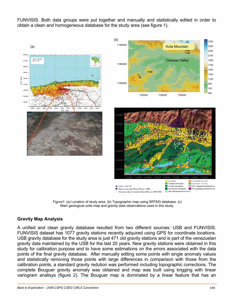
Caracas city is located in northern Venezuela, south of the Cordillera de la Costa Range, in the present basin of Guaire and Valle rivers (figure 1a). The basin is limited to the north by the Sierra el Avila Mountain and runs across the alluvial palins of Valle river (figure 1). On the southern flank of the valley, Las Brisas and Las mercedes schists outcrop. The Avila Mountain is geologically characterized by the San Juan Schist (Urbani and Rodríguez, 2004). Rocks present in all these formations are metamorphic with high pressure and low temperature. The city is within a region that has some microsismicity associated with the San Sebastian-La Victoria fault system, which is defined by a deformation area 400km long in the east-west direction and 70km wide from north to south. Recent seismic microzonification studies have been carried out by the Venezuelan Seismilogical Foundation (FUNVISIS) in Caracas in order to gain some understanding about the possible damages in the city in case of an earthquake (Schmitz et al., 2006). New gravity stations (1077 observations) have been colected in these studies. The objective of this work is to analyze the gravity anomalies over the Valley of Caracas in order to have a possible sediment thickness map for the city. A complete Bouguer anomaly map was built by using gravity observations from Universidad Simón Bolívar (USB) and the new datasets from
Back to Exploration – 2008 CSPG CSEG CWLS Convention 698
FUNVISIS. Both data groups were put together and manually and statistically edited in order to obtain a clean and homogeneous database for the study area (see figure 1).
Figure1: (a) Location of study area. (b) Topographic map using SRTM3 database. (c)
Main geological units map and gravity data observations used in this study.
Gravity Map Analysis
A unified and clean gravity database resulted from two different sources: USB and FUNVISIS. FUNVISIS dataset has 1077 gravity stations recently adquired using GPS for coordinate locations. USB gravity database for the study area is just 471 old gravity stations and is part of the venezuelan gravity data maintained by the USB for the last 20 years. New gravity stations were obtained in this study for calibration purpose and to have some estimations on the errors associated with the data points of the final gravity database. After manually editing some points with single anomaly values and statistically removing those points with large differences in comparison with those from the calibration points, a standard gravity redution was performed including topographic corrections. The complete Bouguer gravity anomaly was obtained and map was built using krigging with linear variogram analisys (figure 2). The Bouguer map is dominated by a linear feature that has an
(c)
(b)
(a)
725000 730000 735000
1155000
1160000
1165000
500
700
900
1100
1300
1500
1700
1900
2100
2300
2500
2700
Caracas Valley
Avila Mountain

Back to Exploration – 2008 CSPG CSEG CWLS Convention 699
increasing grdient from south to north. In order to obtain a residual map that could reflect the local anomalies, this linear gradient had to be removed (figure 3). A residual gravity map is shown in figure 3 with values between -6mgal and 4mgal. The residual map indicates three local gravity lows, one in the western part and the other two in east. Values in the center of each one can be as low as -2mgal. The local low in the west is located over San Bernardino residential area. Those in east, are located over Altamira and Los Palos Grandes areas (northern feature) and in Las Mercedes residential zone (southern feature). A gravity high of about +1mgal runs in the middle of the study area, separating the western feature from the eastern features. These negative gravity anomalies observed in San Bernardino and Altamira and Los Palos Grandes areas coincide with location of alluvial sedmients, but the gravity low observed in Las Mercedes is just over Las Brisas Schist and sediment infill border (figure 4).
Figure2: Bouguer anomaly map using linear variogram analysis.
Figure3: Residual gravity anomaly map after removing a linear gradient.

Back to Exploration – 2008 CSPG CSEG CWLS Convention 700
Figure4: Residual gravity anomaly map on top of the geological map.
Acknowledgements
We are grateful to FUNVISIS for allowing us to access and use its gravity database. Thanks to Eng. Javier Sanchez (FUNVISIS) for his fruitful discussions about the gravity anomaly map for Caracas.
References
Schmitz, M., Hernández, J.J.., Audemard, F., Malavé, G., González, M., Granado, C., Sánchez, J., Andrade, L., and Klarica, S., Avance de Proyectos de microzonificazión s{ismica en las principales ciudades en Venezuela. VII Congreso Venezolano de Sismología e Ingeniería Sísmica, Valencia, 2006, Memorias en CD, 5 pp. Urbani, F., and Rodríguez, J. A., 2004. Atlas Geológico de la Cordillera de la Costa, Venezuela. Edic UCV y FUNVISIS, Caracas, 148 hojas geológicas a escala 1:25.000