greater manchester’s third local transport plan - …€¦ · there are over 9,000 km of roads,...
TRANSCRIPT

Greater Manchester’s third Local Transport Plan 2011/12 – 2015/16

2
Greater Manchester’s third Local Transport Plan 2011/12 – 2015/16
Contents Foreword 5 1. Introduction 1.1 Description of Greater Manchester 7 1.2 Scope of LTP3 9 2. Context for LTP3 2.1 Greater Manchester’s vision for the future 11 2.2 Key challenges in Delivering the Vision 13 2.3 Core objectives for LTP3 19 3. Travel and Transport in Greater Manchester Today 3.1 Introduction 21 3.2 Transport and new development 23
3.3 Key transport issues 27 3.4 Views of the travelling public and businesses 33 3.5 Cross-boundary issues 37 3.6 Integrated Assessment 40
4. Delivering our Objectives
4.1 Introduction 43 4.2 Economy 43 4.3 Carbon and climate change 49 4.4 Public health and wellbeing 52 4.5 Sustainable neighbourhoods and public spaces 54 4.6 Value for money 56 4.7 Transport proposals 57
5. Promoting Travel Choices 59
6. Public Transport 6.1 Better buses for Greater Manchester 65 6.2 Door-to-door Transport 75 6.3 Delivering the Metrolink vision 79 6.4 A rail system for our future economy 86 6.5 Fares, ticketing and information 97
7. Active Travel 7.1 Introduction 102 7.2 Walking for everyday journeys 105 7.3 Making cycling a natural choice 109

3
Greater Manchester’s third Local Transport Plan 2011/12 – 2015/16
8. Highways and Freight 8.1 Managing our highways 115 8.2 Highways maintenance and asset management 125 8.3 Car parking for improved access 136 8.4 Sustainable distribution 140 8.5 Managing the demand for travel 145
9. Wider Issues
9.1 Safe and secure travel 147 9.2 A more accessible transport system 151 9.3 A greener transport system 160
10. Implementation 10.1 Governance 170 10.2 Funding 173 10.3 Implementation Plans 176
11. Monitoring 11.1 LTP2 Performance monitoring 178 11.2 LTP3 Targets and infrastructure 182 11.3 Application of Performance Management 186
Glossary 187 Figures 1.1 Location of Greater Manchester 7 1.2 Indices of Multiple Deprivation 15 3.1 Traffic flows (motorways and A and B roads) 29 5.1 Promoting Travel Choices 60 6.1 Bus passenger journeys 65 6.2 Core bus network 69 6.3 Passenger journeys on Metrolink 79 6.4 Greater Manchester Metrolink and rail networks 81 6.5 Passenger journeys on local train services 86 6.6 Forecast of overcrowded trains 90 7.1 Existing cycle network 109 8.1 Weekday am peak average delay 119 8.2 Freight hotspots and points of interest 140 9.1 KSI and slight injuries 147 9.2 Accident (KSI) clusters 149 9.3 Accessibility to category A interchanges by public transport 152 9.4 Areas exceeding NO2 thresholds 160

4
Greater Manchester’s third Local Transport Plan 2011/12 – 2015/16
Supporting Documents (available at www.tfgm.com/LTP3) • Air Quality Strategy and Action Plan • Greater Manchester Implementation Spend Profiles • Greater Manchester Parking Standards • Integrated Assessments of draft strategy • Integrated Assessments of Local Area Implementation Plans • Local Area Implementation Plans • LTP3 Consultation and Engagement Report • LTP3 Indicators and Targets • LTP3 Trends in Travel and Influencing Factors • Public Rights of Way Strategy • Transport Asset Management and Highway Maintenance Plan

5
Greater Manchester’s third Local Transport Plan 2011/12 – 2015/16
Foreword Greater Manchester is the most important economic centre in the UK outside London, with significant opportunities for future growth. An effective transport network is an essential catalyst to realise the potential of Greater Manchester as it connects people to places in a sustainable manner – places where they can work, study, shop, relax, and access public services. This can help to tackle the challenge of low productivity caused by persistent worklessness in some of our most deprived communities. Meeting this challenge is more critical than ever, as we come out of one of the deepest recessions in generations with lower levels of public funding available. This points to the need for greater clarity than ever on priorities for spending; alongside initiatives aimed at the efficient use of all transport networks to ensure that Greater Manchester moves to a lower-carbon economy whilst maximising every opportunity for economic growth. Through the Greater Manchester Combined Authority – the first of its kind in the country – we have developed new systems of governance which will enable us to take greater control of more of the spending and activities that have historically been managed by central government. This will be complemented by the Local Enterprise Partnership which will support businesses and the public sector to work together to grow the local private sector and develop a shared strategy to increase job creation. These opportunities would not have been possible without the previous contributions of the Association of Greater Manchester Authorities and the Greater Manchester Integrated Transport Authority. Together, they established the Metrolink system as one of the most successful light-rail systems in the country, and developed an innovative programme of funding which prioritises investment in transport infrastructure based on an ability to deliver economic growth. This Local Transport Plan provides us with an opportunity to build on these successes. However, the scale of the challenge of delivering a transport network that can maximise the scope for growth and economic renewal in a time of radically lower levels of funding means that we will need to answer some fundamental questions. These will include how we secure the best value from the public subsidies that go into our bus system; how we balance competing transport policy objectives; how we develop new models of funding for transport; and how we develop the capacity of public transport operators to grow their markets. This Local Transport Plan for Greater Manchester will set out to answer these questions through short and medium term priorities and a longer term vision for transport in Greater Manchester. Through it, we also believe that we will enable Greater Manchester to realise its full economic potential.


7
Greater Manchester’s third Local Transport Plan 2011/12 – 2015/16
1. Introduction 1.1. Description of Greater Manchester
Greater Manchester is a large and complex urban area covering some 500 square miles and has around 2.5 million residents. There is a mix of high-density urban areas, suburbs, semi-rural and rural locations, although overwhelmingly the character of the area, and therefore the pattern of movement, is urban. It has a strong Regional Centre, covering not only Manchester City Centre but adjoining parts of Salford and Trafford, which is the primary economic driver and main retail, leisure, cultural and tourism centre. Greater Manchester is also home to one of the largest student populations in Europe. As a result, there are strong daily traffic flows into the centre, second only to those in London.
However, the pattern of development in the conurbation is polycentric (see Figure 1.1), with each of the ten local authority areas having at least one major town centre, and these local centres of activity are also reflected in the transport network. A number of sub-regionally significant employment sites, as well as cultural and leisure attractions, are also located outside the central core. There are also strong links with neighbouring authorities in Cheshire, Derbyshire, Halton, Lancashire, Merseyside and Warrington and across the Pennines to Yorkshire (in particular Huddersfield) both for commuting and for leisure activities, with the Pennines being particularly important for recreation.
Figure 1.1: Location of Greater Manchester

8
Greater Manchester’s third Local Transport Plan 2011/12 – 2015/16
Greater Manchester is the largest and strongest economic area in the North of the country, accounting for over 40% of the North West’s total productivity. Along with Leeds, it is seen as having the greatest momentum, capacity and economic diversity to close the productivity gap between the north and the south-east of England. However, despite a strong economic performance overall, Greater Manchester contains some of the most deprived areas in the country and regeneration and the addressing of social exclusion remain priorities.
Manchester Airport is a ‘Top 20’ European airport and the largest regional airport outside the south-east, acting as the ‘gateway’ to the north of England, parts of the Midlands and North Wales. It is also a major employer; both directly on site and in terms of associated jobs across the region, as well as being a key driver of wider economic growth, particularly in supporting inward investment and international trade.
As a result of the scale and complexity of development, Greater Manchester has extensive transport networks. There are over 9,000 km of roads, carrying annual traffic of 13,000 vehicle kilometres1 on the motorways and A and B roads. The orbital M60 links to: the east-west M62, serving Liverpool and Yorkshire; the M67/A628 route to south Yorkshire; the M61 and M66, serving south Lancashire and the M56 to Chester, North Wales and the Wirral. The M6, via the A556, is the main north-south link, to the West Midlands, Cumbria and Scotland. In addition to providing long distance links, the motorways around Greater Manchester carry a high volume of local journeys, both within the conurbation and to neighbouring areas.
Many of these local journeys are on the bus network, which carries around 227 million passengers per year, far exceeding the patronage on other public transport modes. The bus network has a strong focus on radial routes into Manchester City Centre, but there are also smaller local networks focusing on each of the main town centres. It is important not only for commuting into these centres and to locations outside Greater Manchester, but is vital for other day-to-day journeys eg for education, healthcare and leisure.
In addition, the light rail Metrolink system is heavily used for commuting and carries around 19 million passengers per year on lines between the city centre and Altrincham, Bury and Eccles via MediacityUK. An expansion of the network is underway, which will double its size.
The rail network carries over 22 million journeys each year. It is of significant importance for commuting, but also offers alternatives to the car for key long distance journeys. The West Coast Main Line provides the main north-south link, while Trans-Pennine rail routes offer an alternative to many destinations along the Liverpool-Manchester-Leeds-York and Manchester-Sheffield-Nottingham corridors, and routes to Preston and Scotland provide links to the north. However, the extent to which rail can provide an alternative is limited by the capacity in the ‘Northern Hub’, where a number of rail corridors come together in the centre of Manchester. This is recognized as the single largest rail bottleneck in the North of England.
1 GMTU Transport Statistics, 2009

9
Greater Manchester’s third Local Transport Plan 2011/12 – 2015/16
The Local Transport Plan needs to reflect the complexity of development patterns and transport networks in the area in order to present a transport strategy responsive not only to the needs of Greater Manchester as an engine of economic growth, but to the distinctive local requirements of the ten Districts.
1.2. Scope of the Document As required by the Local Transport Act, 2008, this third Local Transport Plan contains the policies of the Integrated Transport Authority (in the case of Greater Manchester this will be Transport for Greater Manchester from 1 April 2011) for the provision of safe, integrated, efficient and economic transport to, from and within their area. Although these policies build on the overall direction of transport strategy set out in the previous Local Transport Plans, LTP3 now replaces and supersedes LTP1 (2001-2006) and LTP2 (2006-2011).
The plan was prepared by Greater Manchester Integrated Transport Authority (GMITA) and Greater Manchester Passenger Transport Executive (GMPTE), in consultation with the ten Greater Manchester District Councils and relevant stakeholders. It was then approved by GMITA in March 2011. Under the Greater Manchester Combined Authority Order, 2011, the functions of GMITA were transferred to the Greater Manchester Combined Authority (GMCA) with effect from 1st April 2011. GMCA has asked Transport for Greater Manchester to monitor and review the plan and its implementation on a regular basis.
The LTP is required to contain both a long term strategy and a short term implementation plan. This document therefore sets out a long term strategy to 2026, the delivery of which depends on the availability of funding, and a summary implementation plan for the first four years (to 2015), which reflects the resources that are likely to be made available during the period covered by the Comprehensive Spending Review in October 2010. Detailed Local Area Implementation Plans (LAIPs) have been prepared for each of the ten District areas, and are available on the website www.tfgm.com/LTP3. The Implementation Plans have been prepared locally, taking into account the priorities in each District as set out in their Sustainable Community Strategies. The LAIPs present investment programmes for Year 1, with indicative programmes for years 2-4. These are summarised in Section 10.3. The investment programme will be reviewed annually to take account of any changes to financial circumstances and priorities.
The strategy itself will be reviewed after no later than five years (ie in 2015/16), but we recognise that this may need to happen sooner, given the fact that we are entering a period of significant change, in terms of both governance arrangements and the availability of funding.


11
Greater Manchester’s third Local Transport Plan 2011/12 – 2015/16
2. Context for LTP3 2.1. Greater Manchester’s Vision for the Future
The third Greater Manchester Local Transport Plan (LTP3) provides a clear set of investment priorities and complementary activities that support the maximum potential economic growth in Greater Manchester, whilst also acknowledging the need for lower carbon travel patterns and the importance of addressing the economic and social costs and impacts of deprivation within our community.
In recent years, Greater Manchester local authorities and their private sector partners have developed a new model of working to bring together key activities across housing; spatial and environmental planning; public health; education and skills; crime; and, of course, transport to secure a collaborative approach to accelerating growth, led by the private sector, and driving up the economic activity levels of all our residents.
Looking to the future, the Greater Manchester partners have developed a clear vision to secure our place as one of Europe’s premier city regions. The Greater Manchester Strategy (GMS), published in 2009, sets out the following key priorities that need to work effectively alongside one another for the conurbation to achieve its potential:
• supporting development in the early years of life to put every child in the best possible position
to benefit from formal education in later years;
• supporting better life chances (ie the chances an individual has to improve his or her quality of life) for all, by helping residents to escape the regressive cycle of worklessness and low skills;
• developing a stronger skill-base by securing public and private approaches that improve and widen key skill levels across local residents;
• attracting new talent through initiatives to retain graduates from the local higher education facilities and attract the best talent from elsewhere;
• supporting the economic base through integrated business support mechanisms and investment in digital infrastructure;
• promoting international connectivity to help increase levels of exports out of, and inward investment into, Greater Manchester;
• developing a low carbon economy to meet the challenges of climate change;
• supporting the growth and renewal of the housing market to meet future needs;
• delivering effective governance to optimise the public sector’s contribution to the future growth;
• developing an improved “sense of place”, well-being and quality of life across Greater Manchester; and
• developing our transport system, to best support economic growth, social well-being, environmental improvement and better public health across Greater Manchester.

12
Greater Manchester’s third Local Transport Plan 2011/12 – 2015/16
The GMS also articulates strategic objectives for transport. LTP3 reflects these in order to support the growth of Greater Manchester by:
• prioritising investment in cost-effective major transport interventions that will create maximum
economic benefit for Greater Manchester, whilst also ensuring that this improves the social and environmental benefits of the system as a whole;
• improving access from residential areas, particularly those prioritised for housing growth, to key education and employment areas: particularly the Regional Centre, town centres, Trafford Park and other strategic employment sites;
• improving surface access to Manchester Airport;
• improving the efficiency and reliability of transport networks;
• improving road safety and also enhancing the personal safety and security of travellers on the system; and
• developing an integrated approach to the transport network and travel demand management that helps to support lower carbon travel across Greater Manchester.
The effective delivery of the GMS will require strong leadership and effective coordination across a wide range of activities. This need will sharpen further as we enter a period of unprecedented reductions in the availability of public sector funding, which will require Greater Manchester’s partners to challenge our priorities further and weigh up the balance between the competing policy objectives set out above.
Following 20 years of voluntary co-operation through the Association of Greater Manchester Authorities (AGMA), the Greater Manchester authorities have now received a Ministerial decision to establish the Greater Manchester Combined Authority, which will become the accountable focus across Greater Manchester for integrating economic development, regeneration, planning, housing and transport policies. The authorities also see a Local Enterprise Partnership (LEP) as a key component of these governance arrangements, building on the unique public and private partnership that is already in place. LEPs have been promoted by the Government as a key element of its localism strategy. The Greater Manchester LEP represents a further opportunity for the conurbation’s businesses, local authorities and our key partners to build upon a long period of voluntary collaboration to achieve a step change in our ability to secure private sector led economic growth, whilst ensuring our residents are able to benefit from, and actively contribute to, this growth. Together, the Greater Manchester Combined Authority and the LEP will enable the private sector to play an even more active leadership role in securing economic growth, allowing for the effective alignment of decision making and delivery in key areas such as economic development, regeneration, planning, transport, housing, inward investment, business support, marketing and tourism, and employment and skills.
The reformed public sector governance system also includes a new approach to the way in which transport systems are managed in Greater Manchester. The current transport governance arrangements have been re-focused around the new “Transport for Greater Manchester” which will provide an enhanced focus on coordinating transport and economic regeneration objectives to effectively prioritise and deliver initiatives that best support the GMS objectives. Alongside this, we are developing with the Government new models of working (or “protocols”) for local rail, highways and bus systems.

13
Greater Manchester’s third Local Transport Plan 2011/12 – 2015/16
The Greater Manchester rail protocol outlines the expectations for engagement between Department for Transport (DfT), Network Rail and Greater Manchester across the range of decision making processes. It sets out the process for engagement in terms of the key stages of policy development, strategic planning, specification, procurement, project delivery and service delivery. The protocol provides an operational framework to ensure that mechanisms for funding, specification and delivery available to both DfT and Greater Manchester are used in ways that deliver the best outputs in terms of a rail network to meet our economic and transport objectives.
Responsibility for the management of the road network in Greater Manchester is split between the Highways Agency and the ten local highways and traffic authorities. This fragmentation of responsibilities makes co-ordination of activity and the smooth operation of the network extremely challenging. With the establishment of Transport for Greater Manchester there are opportunities for much greater integration and closer working relationships with the Highways Agency (HA) and the ten authorities for the operation and development of both the HA network and local road network. The highways protocol recognises the areas of opportunity which can be exploited and acknowledges that national, regional, city region and local priorities, which will not always be consistent, will need to be addressed in a manner that balances all objectives. Three core strands of activity have been identified as the focus for further detailed work: (a) strategic network development; (b) day-to-day management; and (c) building an evidence base/information sharing.
There is the potential for the bus system to play a bigger role in meeting our economic, social and environmental objectives and we are investigating how best to achieve this. For example, we have been working with DfT to identify how we can deliver better economic, social and environmental outcomes for the bus network in Greater Manchester, even if financial support for the network from the public sector has to be reduced. In other words, it is about how to achieve more from the public subsidy and infrastructure investment that goes into the bus system in Greater Manchester. This approach will also enable us to define clearly the role that bus transport can play - and to identify the optimum use of subsidies to maximise the impact of the bus system - in delivering sustainable ‘Gross Value Added’ (GVA) growth in Greater Manchester (ie jobs and productivity) and reductions in deprivation.
2.2. Key Challenges in Delivering the Vision
The changing environment around public spending, driven by national policies to address the fiscal deficit, further highlights the importance of the GMS priorities. As we enter a period of significantly lower relative public spending, it will be more critical than ever for Greater Manchester both to have full clarity on priorities around how to deploy limited public resources, and also to give a renewed focus to increasing the scope of the area to contribute to new levels of national productivity. The four critical sets of challenges set out here, which relate to economic, environmental, public health and fiscal pressures, are not exhaustive; the proposed objectives listed at 2.4, and described in greater detail in chapter 4, aim to provide a fuller articulation of the challenge for LTP3. However, the following challenges will very much shape and determine all our approaches to meeting our objectives in the coming years.

14
Greater Manchester’s third Local Transport Plan 2011/12 – 2015/16
Supporting Economic Growth and Tackling Deprivation The Manchester Independent Economic Review (MIER) concluded that Greater Manchester has the potential to become an economic powerhouse for the UK that would be second only to London. However, MIER also showed us that Greater Manchester continues to punch below its weight in terms of its potential, and is held back by low productivity that stems from persistent worklessness in many of its most deprived communities. Most importantly, MIER clearly demonstrated the value of focussing on the holistic economic needs of Greater Manchester as a functioning ‘place’, and to determine clear priorities across regeneration, housing and transport activities, rather than within these traditionally individual areas of public service delivery, so as to deliver fully integrated solutions that offer the maximum scope for private sector investment and reduced levels of deprivation whilst ensuring good value for money. This approach lies at the heart of GMS and is key to the Greater Manchester Combined Authority model and emerging LEP proposal, and shapes the priorities for LTP3.
The regeneration of the Regional Centre and the main town centres as employment locations, service centres and, increasingly, places to live will remain key priorities. AGMA is now preparing a Greater Manchester Spatial Framework (GMSF), which will inform priorities for investment decisions to support development which is important for the conurbation, for example by securing necessary supporting infrastructure. The GMSF will set out guiding principles for development and investment within a framework which underpins economic growth, reduces carbon emissions, addresses entrenched economic and social exclusion and creates attractive places with high environmental quality.
The priority will be to drive growth through private sector-led investment strategies. We will support the achievement of this policy, not only by developing sustainable transport approaches which link people and skills to jobs and opportunities, but also by bringing public and private resources together to deliver much-needed infrastructure. We want to remain at the forefront of developing new funding models, building upon AGMA’s success in leading the “Evergreen” Investment Fund and working with Government on new approaches to funding. This includes Accelerated Development Zones (ADZ), where a concentrated ‘offer’ is developed to support a key economic growth point that already benefits from distinctive features such as business clustering.
There are still significant issues of deprivation in the conurbation which are reflected in all aspects of life: employment, education/training and health. These issues not only hold back the prospects of some communities being able to benefit fully from the opportunities that Greater Manchester offers, but they also critically inhibit Greater Manchester’s productivity through persistent worklessness and act as a major ongoing benefit burden both locally and nationally. The Greater Manchester authorities, through the GMS, have recognised the critical importance of addressing this to maximise the impact on our future economic growth.

15
Greater Manchester’s third Local Transport Plan 2011/12 – 2015/16
Transport can be a barrier to accessing work, healthcare and education/training and traffic can affect the safety and attractiveness of neighbourhoods and the wellbeing of residents. There remains significant deprivation around the core of the conurbation, in a number of priority outer-lying areas and in parts of many of our towns throughout Greater Manchester (see Figure 1.2). The need to encourage recovery and growth in the current difficult economic circumstances means that transport investment will need to be focussed where it can be of greatest benefit to the economy in getting people into education/training and work, and in supporting further regeneration. Therefore, we will maintain and strengthen initiatives that help our most socially and economically excluded neighbourhoods and communities to contribute more fully to a future vibrant economy. Local initiatives to increase walking and cycling will not only provide low cost travel options but, by improving health, will also benefit the economy through improved productivity.
Figure 1.2: Indices of Multiple Deprivation
Additional growth will also bring a number of challenges in terms of the capacity and reliability of transport networks, particularly those serving commuters accessing new jobs in the Regional Centre. Significant future housing growth is planned for the core of the conurbation, with good access to jobs, but the focus of economic development in the centre, which will be critical for many of our most important business sectors, will present further challenges for the efficiency and reliability of the road network, so increasing the need for effective public transport.

16
Greater Manchester’s third Local Transport Plan 2011/12 – 2015/16
We will, therefore, need to introduce measures to tackle these problems. However, we will not be making any proposals for congestion charging or workplace parking charging. Rather, our focus will be on a high quality, targeted investment in public transport and other sustainable modes, alongside measures to maximise the efficiency across road and public transport systems. In certain key areas, particularly relating to the key radials into the Regional Centre and Inner Ring Road, we will also need to secure targeted investment in new/improved parts of Greater Manchester’s strategic road network in order to maintain efficiency across the network as a whole.
Delivering a Low Carbon Economy Greater Manchester aspires to move towards a lower carbon economy and society and reap benefits in the form of new competitive advantages, higher quality of life, improved environmental quality, better neighbourhoods and homes for more self-reliant communities. This will require us to develop innovative solutions to address the carbon impact of growth, and travel in particular, whilst also making our infrastructure more resilient to the impacts of climate change. It also offers real opportunity to develop a new role for low carbon transport innovation at the heart of new entrepreneurial activity in Greater Manchester. Furthermore, it also mirrors the Government’s recognition of the relationship between low carbon and economic objectives. In September 2010, the Government announced its intention to create a Local Sustainable Transport Fund (LSTF), to drive progress in this policy area.
Greater Manchester currently has a CO2 emissions footprint of 15.8 million tonnes per annum. Based on government targets, set out in the Low Carbon Transition Plan, this needs to be reduced to below 10 million tonnes by 2020 and to below four million tonnes by 2050. Carbon emissions from transport in Greater Manchester account for over 30% of total emissions, and future growth projections suggest that radical change will be required if we are to achieve the more ambitious low carbon targets as set out in the GMS.
It will be possible, given adequate resources, for Greater Manchester to reduce carbon emission from transport by the required amount through a combination of energy efficiency, alternative fuels and modal shift, either to active travel modes for short journeys or to public transport for longer ones. Effective measures include a reduction in the need to travel, improved pedestrian and cycle infrastructure, support for the take up of low carbon vehicles and fuels, low carbon buses, driver training, improved energy efficiency of the highways networks through better network management (including stricter enforcement of speed limits), and targeted ‘Smarter Choices’ initiatives to bring about travel behaviour change. These measures will help Greater Manchester to adapt to rising oil prices by providing alternative, and economically advantageous, travel opportunities. They also present opportunities to develop innovative solutions for delivery that secure maximum market-led investment eg in cycle hire schemes. In the longer term, electric vehicles have the potential to make a contribution to carbon reduction as vehicle prices become more competitive. We are keen to work with the Government to position Greater Manchester at the forefront of the national agenda to deliver electric vehicle infrastructure through public/private partnership delivery initiatives and have been successful in bidding for funding to support a network of charging points for electric vehicles, through the ‘Plugged in Places’ initiative.

17
Greater Manchester’s third Local Transport Plan 2011/12 – 2015/16
Alongside this, climate change projections indicate the potential for more extreme weather events over the coming decades. It is predicted that the North West will see hotter, drier summers and wetter, warmer winters. This could have serious implications for the management of transport infrastructure. The impact of a future oil production peak will have a profound impact on transport, impacting on the availability and price of oil, including all of its derived products. Rising electricity prices will impact on Metrolink and electrified rail, as these costs are likely to be passed on to passengers to some extent.
Protecting and Enhancing Public Health and Safety Public health is a further significant cost of deprivation in Greater Manchester, where there is some of the lowest life expectancy at birth in England for both men and women. The health sector considers that eight out of the ten Greater Manchester Districts have overall ‘bad health’. 130,000 people in Greater Manchester are on incapacity benefit, which not only impacts on those individuals’ life chances, but also reduces Greater Manchester’s productivity and increases the public cost of benefits. Many health problems, such as obesity, mental illness, diabetes, heart disease, asthma and respiratory disease, are related to inactivity or poor air quality, both of which require transport solutions within a suite of measures. Active travel can play an important role in increasing overall levels of activity and therefore improving public health. According to the NHS2, the resulting cost to the UK economy of absenteeism, premature death and treatment is between £8 billion and £10 billion per year.
Childhood obesity rose from 14% for boys and 15% for girls to 24% and 26% respectively between 1994 and 2004, a period where walking to school fell from 61% to 53%. Increasing travel by active modes (walking, cycling and walking/cycling to public transport) therefore needs to be a priority. Recent efforts aimed at school travel planning with Greater Manchester have begun to reverse this decline but we remain at a low base.
Air pollution also continues to act as a real threat to people’s health in Greater Manchester. The European Environment Agency estimates that up to 50,000 people die prematurely in the UK from exposure to air pollution, and the majority of this is due to particulates. Nitrogen Dioxide (NO2) also causes serious health problems, and failure to meet reduction targets is a UK wide problem. Many areas in Greater Manchester currently exceed limits for NO2 and current forecasts by Department of the Environment, Food and Rural Affairs (DEFRA) project that this will remain the case in the period to 2015.
In 2009, over 9,000 people were injured in accidents on Greater Manchester’s roads; 794 of them were either killed or seriously injured (KSI). In addition to the human cost of road accidents, the financial cost of these accidents is estimated at around £225 million, taking into account the loss of output, NHS costs, emergency services costs, vehicle repair or loss costs and traffic delays3. However, there is a positive trend in overall road safety here, with the number of people killed or seriously injured on Greater Manchester’s roads falling by 6% between 2008 and 2009: the fourth consecutive annual reduction. Over time, as our network has become relatively safer, our attention
2 Be Active, Be Healthy – A Plan for Getting the Nation Moving, Department of Health 2009
3 Calculated using DfT figures: http://www.dft.gov.uk/webtag/documents/expert/unit3.4.php#03

18
Greater Manchester’s third Local Transport Plan 2011/12 – 2015/16
is shifting from local highway schemes towards driver behaviour, which remains a very significant factor in accidents. Casualties, particularly child casualties, are also highest in deprived communities (which can most acutely suffer from through traffic and rat running), adding further to the challenges of deprivation discussed above.
Supporting National Transport and Spending Priorities In addition to addressing the above challenges, our final LTP3 strategy is designed to ensure that it fits well with Government transport policy priorities and that it reflects the implications of the national Spending Review process.
The Government’s priorities, as set out in the ‘Programme for Government’ include three clear policy dimensions for transport: that “a modern transport infrastructure is essential for a dynamic and entrepreneurial economy”; that transport infrastructure is critical “to improve well-being and quality of life”; and finally that our national transport system needs to be “greener and more sustainable“. In September 2010, the Government announced its intention to create a new Local Sustainable Transport Fund to “challenge local transport authorities outside London to develop packages of measures that support economic growth and reduce carbon in their communities as well as delivering cleaner environments, improved safety and increased levels of physical activity”. The Government’s priorities mirror very closely the strategic intent set out in the GMS, and the objectives for LTP3, in terms of their recognition of the three key drivers for transport policy: economic growth, quality of life and carbon reduction. Therefore, the Greater Manchester Combined Authority and Transport for Greater Manchester will be keen to explore with Government the potential for the newly proposed Fund to support a number of the initiatives set out in this strategy.
However, alongside this, in October 2010, the Government published the outcome of its Spending Review for the period 2011/12 to 2014/15, shaping the scale of public resources that are available to support the short-term delivery of this LTP3 strategy. The impact of the Spending Review on transport results in major challenges in prioritising limited funds to address the outcomes that matter most in the short term. Our approach is to prioritise in a manner that complements the Government’s priorities for the Spending Review, which clearly point towards activities that provide “substantial economic value”, targeted at “those most in need” and delivered increasingly at the local, rather than national, level.
In accordance with the Government’s aims, there will be an increased need for private sector investment in infrastructure, through the planning system. Therefore this is fundamental in support of our LTP strategy.

19
Greater Manchester’s third Local Transport Plan 2011/12 – 2015/16
2.3. Core Objectives for LTP3
The national policy context for LTP3 will remain under review to ensure that the plan is fully aligned with the priorities of the new Government.
However, in developing the key aims and objectives for LTP3 within this strategic context, a number of key themes are consistent across national and local strategic priorities, namely: economic growth, environmental sustainability, health and wellbeing, and value for money. This has led to the formulation of objectives for LTP3 as follows:
• to ensure that the transport network supports the Greater Manchester economy to improve the
life chances of residents and the success of business;
• to ensure that carbon emissions from transport are reduced in line with UK Government targets in order to minimise the impact of climate change;
• to ensure that the transport system facilitates active, healthy lifestyles and a reduction in the number of casualties; and that other adverse health impacts are minimised;
• to ensure that the design and maintenance of the transport network and provision of services supports sustainable neighbourhoods and public spaces and provides equality of transport opportunities; and
• to maximise value for money in the provision and maintenance of transport infrastructure and services.

21
Greater Manchester’s third Local Transport Plan 2011/12 – 2015/16
3. Travel and Transport in Greater Manchester Today 3.1. Introduction
The general economic growth trend in Greater Manchester since the early 1990s has seen a resurgence in the demand for travel into and across the conurbation. There are now around 1 million commuting trips made each weekday morning within Greater Manchester, with a further 140,000 trips coming into the conurbation from neighbouring areas, and around 100,000 trips departing Greater Manchester for neighbouring areas. Home working accounts for around 7% of working residents in Greater Manchester.
Year on year, on average, journey times across Greater Manchester have increased as the economy has grown and demand for travel has increased with it. Over 60% of people working in Greater Manchester now travel for more than 20 minutes to work and nearly 25% of workers commute for over 40 minutes each morning. The majority of trips on the local motorway network are bound for Greater Manchester, particularly in the morning peak, which indicates the importance of commuting from outside the area.
The strategy adopted during the first two LTPs has resulted in a range of successful interventions that have enabled Greater Manchester’s transport system to make some important contributions to the economic, social and environmental vitality of the conurbation. In particular, we have supported a revitalised Regional Centre and helped to reinvigorate other key and local centres through improvements to accessibility, which have included the following achievements. We have:
• invested in over 274 km (170 miles) of Quality Bus Corridors which, with associated investment
by operators, resulted in an addition of 8 million passengers per year and a 19% cut in accidents;
• improved and, in some cases rebuilt, many of the bus stations within Greater Manchester, as well as creating the new Shudehill Interchange in Manchester city centre;
• introduced the innovative system of Metroshuttle buses in Manchester city centre, Stockport town centre and Bolton town centre, which now carry an annual 2.5 million, 200,000 and 100,000 passengers respectively;
• replaced over 32 km (20 miles) of Metrolink track, improving quality of the ride and reducing noise4;
• upgraded a number of stops across the current Metrolink system and begun the work to deliver the future network;
• upgraded facilities at a range of local rail stations, including Salford Central Rail Station;
• provided almost 640 additional park and ride spaces at a number of locations on the rail and Metrolink system;
• delivered the Ground Transport Interchange at Manchester Airport and provided a third platform at the Airport station;
• completed the Manchester-Salford Inner Relief Route, which has contributed significantly to the reduction of traffic passing through the city centre;
4 GMPTE Metrolink Blockade Evaluation, 2007

22
Greater Manchester’s third Local Transport Plan 2011/12 – 2015/16
• invested in targeted local safety schemes and supported driver improvement and speed awareness courses, which have contributed to a reduction in the numbers of people killed and seriously injured on roads;
• delivered pedestrian friendly schemes in a number of our town centres;
• supported schools and employers to develop Travel Plans; and
• provided improved facilities for cyclists, including advanced stop lines at traffic signals, cycle parking at stations, cycle lanes and off-highway routes.
Through these measures we have achieved the majority of our LTP2 targets (see section 11.1), but more needs to be done through LTP3 to achieve our objectives.
Section 3.3 describes some of the key trends and issues for the conurbation as a whole. There will, however, be variations between individual Districts, which will be referenced in the Local Area Implementation Plans.

23
Greater Manchester’s third Local Transport Plan 2011/12 – 2015/16
3.2. Transport and New Development
The Greater Manchester planning authorities are currently producing their Core Strategies, setting out the long term spatial vision (up to 2026/27) and the broad quantity and geographic distribution of different types of development. As part of the new governance arrangements for Greater Manchester, we have developed closer working relationships with the Highways Agency on planning issues. This has led to the development of a protocol through which the ten planning authorities, the Highways Agency and Transport for Greater Manchester have agreed to work together to identify the transport implications of developments proposed in Local Development Frameworks, determining how best to mitigate the negative impacts. Through this mechanism, agreement will be reached both on satisfactory arrangements to deliver the development planned in the first five years of the emerging Core Strategies and on an agreed process to address issues in the medium to long term. As a result, District Councils will be able to provide aligned, cohesive and deliverable Infrastructure Plans as part of their Core Strategies.
As part of this work, a joint study with the Highways Agency has identified the cumulative impact that the planned development is likely to have on transport networks. The key findings from high level modelling were that:
• the concentration of development in the centre of the conurbation, which is well served by
public transport, is likely to increase demand for travel by those modes, but also potentially lead to capacity issues on rail and Metrolink;
• elsewhere, increased car use is likely to increase journey times on motorways and radials into the city centre; and
• as a result of increased congestion, bus travel is likely to become less attractive and CO2 emissions from transport will increase.
A programme of more detailed modelling is being undertaken at District level to understand the more local impacts and to identify the measures required to mitigate them. These will include measures to:
• manage congestion and improve bus reliability;
• increase the capacity of public transport;
• limit the generation of private traffic from new development; and
• encourage active travel.
As noted above, a Greater Manchester Spatial Framework is being produced in parallel to the development of the Core Strategies. This will identify key housing and employment areas, establishing a coherent set of spatial priorities for delivery and investment in support of the Greater Manchester Strategy. An important role of LTP3 will be to ensure that development in these locations is supported by appropriate transport infrastructure and services.

24
Greater Manchester’s third Local Transport Plan 2011/12 – 2015/16
The key locations identified for economic development are described below. The Regional Centre The Regional Centre, which includes parts of neighbouring Salford and Trafford as well as Manchester City Centre, is a nationally significant centre for financial and professional services, knowledge-based creative and new media industries, cultural events, conferencing and retail. As set out in the ‘Transport Strategy for Manchester City Centre’5, there is potential for employment in the centre to grow by 50,000 over the next ten years6, resulting in 30% more inbound trips each day. The key transport challenges will be to increase the mode share of public transport and cycling in order to keep the level of car traffic more or less constant, and to improve traffic movements around, rather than through the centre. Key development areas within the Regional Centre include:
• The Corridor, Manchester (connecting the city centre to the two Manchester universities, the Royal Northern College of Music and the Central Manchester Hospitals). The businesses and institutions currently employ 55,000 people and investment programmes are expected to drive this up to 77,000 by 2020;
• MediacityUK (a location for creative and digital and new media, including the BBC and Granada TV), where 15,000 jobs could be created7 once the site is fully developed;
• Sportcity (an established location for internationally significant sports facilities);
• Salford Quays and Trafford Wharfside, which are developing as a centre for culture, entertainment and internationally-significant sports venues (at Old Trafford); and
• City centre (core) Manchester, including the Chapel Street area of neighbouring Salford, which acts as an important national and international location for financial and professional services, retail and culture.
Manchester Airport Passenger numbers at the Airport, which serves a wide area of the North of England, are forecast to grow to 32 million by 2015, and there is capacity to service more than double the current passenger numbers. The transport challenge, as set out in the Airport’s Ground Transport Plan8 include the need to reduce congestion on the motorway and local road network by increasing the use of public transport and to improve access to jobs at the airport from the surrounding areas, which include areas of significant deprivation. There is a need to ensure good access not only from within Greater
5 ‘Transport Strategy for Manchester City Centre’, Manchester City Council, 2010
6 AGMA Forecasting Model
7 Amion Consulting report for MediacityUK, 2006
8 Manchester Airport Ground Transport Plan can be found at http://www.manchesterairport.co.uk/manweb.nsf/AttachmentsByTitle/TransportStrategy/$FILE/Grndtrans-screen.pdf

25
Greater Manchester’s third Local Transport Plan 2011/12 – 2015/16
Manchester, but from neighbouring areas, particularly Cheshire East, where major businesses rely on the Airport. An area to the north of the Airport has been identified as a significant opportunity for economic development. ‘Airport City’ will maximise the potential of the Airport to attract investment and increase economic activity while bringing positive benefits to the deprived Wythenshawe area. Airport City will require good, direct transport links to the Airport’s Integrated Transport Hub. We will work with the Highways Agency and Manchester City Council to ensure that surface access to the Airport is not compromised through the development of Airport City. Trafford Park Trafford Park includes both the largest industrial estate in Europe and the neighbouring Trafford Centre, a sub regional shopping facility co-located with a range of regional sport and leisure facilities and office development. Research in 2008 found that some 1,400 companies are based in the Park, employing 32,000 people and future growth is expected, through the Trafford Local Development Framework, particularly in the retail, wholesale and distribution sectors. Development in the area will be led by the Trafford Park Masterplan. Transport challenges relate to managing congestion on the motorway network and improving opportunities for travel by non car modes, especially from local communities in Trafford and Salford from which existing public transport links are poor. However, the provision of improved public transport is made more difficult by the low employment densities in much of the local area and the prevalence of shift working. Area-wide travel planning initiatives will therefore play an important role in improving access. Kingsway Business Park Kingsway, in Rochdale, is a 170 hectare (420 acre) mixed use business park close to junction 21 of the M62, making it an attractive location in relation to Manchester, Leeds and beyond. It is anticipated that over 7,000 jobs will be created over a 10-15 year period. The development will require improved public transport links to Rochdale and beyond to ensure that the local workforce can access the site by sustainable modes. Town Centres The main town centres of Altrincham, Ashton-under-Lyne, Bolton, Bury, Oldham, Rochdale, Stockport and Wigan, are all well placed to benefit from the existing concentration of activity and good accessibility, with Bolton and Stockport being the most economically significant. The challenge for the LTP will be to ensure that transport supports the major regeneration plans that exist for each of the centres, so that footfall is maximised, whilst reducing carbon emissions. It will also be important to support the role that smaller town centres can play in the provision of local services and to maximise the role of sustainable transport in improving access. Manufacturing/Logistics Sites Planning permission has been granted for a multi-modal freight interchange at Port Salford, on a site at Barton on the north bank of the Manchester Ship Canal, immediately west of the M60. This

26
Greater Manchester’s third Local Transport Plan 2011/12 – 2015/16
will become an important logistics hub for the west of the conurbation, utilising waterways and links with the Port of Liverpool, and also providing an intermodal rail terminal and rail linked warehousing. Opportunities for larger scale manufacturing and/or logistics have also been identified at Carrington (Trafford) and Cutacre (Bolton). Each of these locations will require additional infrastructure in order to bring forward development.
Other significant locations
In addition to these key locations there is a need to improve access to significant employment sites that are already under development: at Ashton Moss (in Tameside and Wigan South Central. There are also locally significant new development areas, both residential and employment, in each of the ten Districts’ Core Strategies. Examples of these are: Hollinwood (Oldham), Horwich (Bolton), north of Bury, Northleigh (Wigan), Rochdale West, south of Hindley (Wigan), ‘Trafford Centre Rectangle’ (Trafford) and Woodford (Stockport). Where a need for access improvements has been identified, the Local Area Implementation Plans set out the approach of the local authorities to supporting this development, and schemes could be brought forward within the timescales of this strategy, subject to the development of business cases and the availability of funding.
Significant private sector-led economic growth has been proposed for the Liverpool-Manchester corridor, branded as the ‘Atlantic Gateway’. A focussed list of projects has been developed by the promoters, aimed at delivering economic growth through, for example, improved port infrastructure, science and innovation, enhanced connectivity (rail and broadband) and provision of sustainable energy. Port Salford is included in the programme but other projects, outside Greater Manchester, have the potential to drive economic growth and will therefore have implications for transport to and from Greater Manchester. We will need to work closely with the private sector as well as the Local Economic Partnerships for Greater Manchester, Liverpool City Region, Cheshire and Warrington to deliver any required infrastructure.
Other key sites outside Greater Manchester, that could be brought forward during the timescale of this plan and could have significant transport implications, include Omega (Warrington) and Parkside (St Helens). We will work with neighbouring authorities as proposals are developed, particularly in terms of the impact on the west of the conurbation.
Key Sports and Leisure Destinations
Greater Manchester is home to a wide range of major leisure destinations, from rural-based activities on the fringes to a number of nationally recognised museums and significant entertainment destinations in the main centres, together with the greatest concentration of Premier League football outside the capital. There is an ongoing need to manage the impact of major sporting and other leisure events on the transport network.

27
Greater Manchester’s third Local Transport Plan 2011/12 – 2015/16
3.3. Key Transport Issues Public Transport Greater Manchester’s transport strategy has been to manage the additional demand for travel by encouraging more commuting by public transport. This has been supported by local planning policies that have focused primarily on encouraging the growth of Manchester city centre and our other main town centres, which are generally more accessible by public transport. This has been successful in supporting a growing economy to date and, as a result, since the start of our first LTP: • local rail travel has increased from 17 million journeys in 2001/2 to 22.7 million in 2009/10
• Metrolink travel increased from 18.3 million journeys in 2001/2 to 20 million journeys in 2008/9, and although this subsequently fell back to 18.7 million during 2009 while the system was closed for upgrades, it had already recovered to 19.1 million journeys by the summer of 2010; and
• Overall local bus travel has remained fairly stable, increasing slightly from 223 million journeys in 2001/2 to 227 million in 2009/10.
In particular, there has been a significant increase in the proportion and number of peak-time commuting trips into Manchester city centre over the past decade, with public transport, cycling and walking now accounting for 70% of morning trips into the city centre compared to 61% in 2002. This has been achieved while the overall volume of peak-time travel into the centre has increased. However, this growth in demand for public transport is such that it has resulted in growing issues of overcrowding on the local rail and Metrolink systems in particular.
We have been successful in recent years in securing Government funding for additional trams on the Metrolink system, which are now coming into service, to address the immediate overcrowding problem. The expansion of the network, which is now underway, will enable the system to support significant further demand for tram travel.
We have targeted significant investment from GMITA/PTE, local highway authorities and bus companies, to secure improvements in bus performance particularly through the Quality Bus Corridor (QBC) programme. This programme has delivered improvements to service reliability, journey times and passenger facilities and led to significant increases in patronage on some corridors.

28
Greater Manchester’s third Local Transport Plan 2011/12 – 2015/16
However, the following challenges remain:
• Rail overcrowding is a significant issue9 and we have been working closely with the DfT for some time to secure the additional carriages that are essential to allow local rail services to build upon the success of recent years;
• The capacity of the local rail system is limited, and expansion depends on delivery, by Network Rail, of the ‘Northern Hub ‘project which is designed to provide the capacity for additional train services to pass through the central Manchester stations. The Northern Hub is also important in improving connectivity to other northern cities such as Leeds, Liverpool, Preston and Sheffield, and is supported on a wide basis across multiple authorities. This is a stated priority for Network Rail;
• Despite patronage growth on some corridors, levels of overall bus usage have remained static over the last 10 years. There is a need to ensure that the network does not contract, as a result of the current financial pressures, to the detriment of the most vulnerable users; and
• To achieve significant modal shift, the bus network needs to attract more commuters. Whilst high quality services are being delivered by the best operators, particularly on the QBCs, quality on the rest of the network needs to be raised.
9 National Passenger Survey, Autumn 2010, Passenger Focus

29
Greater Manchester’s third Local Transport Plan 2011/12 – 2015/16
Car Travel The growth in the economy and the increase in car ownership have also led to an increase in overall road travel in Greater Manchester. Nationally, 72% of all adults aged 17 and over (an estimated 34.5 million people) held a full car driving license in 200810. Locally this has been managed to a reasonable degree through the completion of the M60 motorway at the start of the last decade, which has acted as a short-term pressure valve, and also by the increase in public transport travel discussed above. As a result: • the total number of vehicle kilometres on A-roads has remained steady over the decade (see
figure 3.2);
• the number of serious accidents around the local road network fell significantly during the last decade; and
• the number of morning peak car journeys into Manchester city centre has reduced by 15% over the last ten years, whilst total commuting numbers have increased, with journeys transferring onto public transport, cycling and walking alternatives.
Figure 3.1: Traffic Flows (Motorway, A and B Roads)
10 Transport Trends 2009, Department for Transport

30
Greater Manchester’s third Local Transport Plan 2011/12 – 2015/16
However, some significant challenges remain:
• the total number of vehicle kilometres on the local motorway system (see Figure 3.2) has increased by 25% since 2000 (the year in which the M60 motorway ring was completed), presenting challenges on many key sections, with average speeds of just 34 mph across the motorway system in the morning peak period;
• capacity pressures on sections of key radials into Manchester City Centre, particularly the Inner Ring Road, require improvements, along with routing and traffic management changes, to more effectively distribute traffic around, instead of through, the city centre;
• 80% of cars on key commuting routes in the morning peak have just the driver on board;
• there are some areas of the conurbation where congestion causes serious issues for local communities;
• much of the previously available capacity on public transport, particularly on rail and Metrolink systems, into Manchester city centre has now been taken up;
• car trips still account for nearly 60% of all commuting trips into the other key Greater Manchester centres outside Manchester city centre; and
• emissions from road traffic accounted for over 60% of all NO2 and PM10 (particulate) emissions in Greater Manchester in 200611 (and the fact that these are emitted at ground level means they have a significant impact on human health); and
• road traffic is a major source (27%) of carbon emissions in Greater Manchester12.
Walking and Cycling In recent decades, the growth in car ownership and use has resulted in a decline in cycling and walking. Although the number of walking trips rose by 2% between 2003/4 and 2007/8, this has not been enough to reverse the previous downward trend. Around 15% of people commuting by car travel less than 2km (just over 1 mile) – and more than 30% of car commuters travel less than 5km (around 3 miles). This represents a major opportunity for modal shift, which will be beneficial to health and will reduce both local congestion and global carbon emissions. The challenge is to make car drivers aware of the opportunities and benefits of making at least some of their journeys by cycle or on foot where possible.
Measures put in place over the last ten years to improve safety, provide infrastructure and promote sustainable travel have had some success as follows:
• the number of people cycling has increased by 17% since 2005; and
• surveys have recorded higher levels of people walking into key centres during the morning peak.
There are further opportunities for increasing cycling to work, particularly by improving the environment for cyclists along key routes to major employment destinations, such as The Corridor, Manchester City Centre and the other major town centres, by re-routing general traffic, reallocating road space to buses and cyclists and investing in cycle infrastructure and parking.
11 EMIGMA Atmospheric emissions inventory for Greater Manchester
12 Manchester: The Green Energy Revolution Final Report (2005). Quantum Strategy & Technology & Partners

31
Greater Manchester’s third Local Transport Plan 2011/12 – 2015/16
However, there are significant challenges in bringing about the culture change that would make walking and cycling the natural choice for many short journeys. Safety, both in terms of protecting walkers and cyclists from motorised traffic and increasing personal security, is vital in this respect. While safe, off-road routes can be provided, safety also needs to be improved for vulnerable road users throughout the network.
Cycling has a raised profile in Manchester due to the presence of the national cycling team at the Velodrome and the promotional ‘Skyrides’ run by British Cycling (in conjunction with Sky Broadcasting and Manchester City Council) and we need to build on this in terms of encouraging people to try cycling for their everyday journeys.
While planning policies in recent years have reduced the number of new out-of town developments, many key facilities are located beyond walking or cycling distance, so many day to day activities require motorised transport. A lack of secure cycle parking at many stops and stations means that the potential to combine cycling with public transport for longer journeys is not being realised. New developments are often designed to provide good access for cars, but pay less attention to access by bike or on foot. They fail to provide convenient direct routes or not providing sufficient cycle parking.
Overarching Transport Issues We have developed a strong understanding of the travel-related issues facing Greater Manchester residents, workers, businesses and other stakeholders13 through extensive strategic consultation activity. The key issues that are most regularly raised include:
• Environmental and public health concerns. An increasing number of people and businesses across Greater Manchester recognise the carbon and air quality implications of travel by car, and are looking for alternative travel options that fit with their busy lives (this reflects the national picture: a 2006 survey14 showed that 46% of respondents were willing to reduce their overall car use). Traffic noise is also a significant concern for many Greater Manchester residents. Many communities live alongside the roads with the heaviest traffic flows and highest levels of pollution. The impacts in terms of health and wellbeing, pollution- related illnesses, road accidents and community severance, are felt disproportionately by people in lower-income groups (who tend to live in these areas) and particularly by children.
• Accessibility. Most people and businesses feel that it is important to ensure that our local transport system is accessible for all, including people with disabilities and those on low incomes. People who live away from the main routes, especially in rural areas, are concerned about infrequent (or sometimes non-existent) public transport services. There is a growing recognition of the need to better integrate travel considerations into housing and commercial developments.
13 Including local authorities, voluntary and community groups, local councillors and Members of Parliament
14 ‘A review of public attitudes to climate change and transport’, Department for Transport, 2006

32
Greater Manchester’s third Local Transport Plan 2011/12 – 2015/16
• Changing patterns of working and living. Modern lifestyles and working patterns are increasingly cited as presenting challenges for people and businesses in using more sustainable forms of travel. The need for more flexible ticketing systems and better services outside traditional “9-to-5” pattern are increasingly highlighted as key obstacles to using public transport.
• Integration/end-to-end journeys. Businesses and residents continue to highlight the importance of integrated transport service provision, ticketing and information in enabling them to travel most effectively (including for longer, cross-boundary journeys) and by the most appropriate form of transport as they go about their daily lives.

33
Greater Manchester’s third Local Transport Plan 2011/12 – 2015/16
3.4. Views of the Travelling Public and Businesses Existing consultation and survey information We are keen to ensure that our transport investment priorities fit closely with the needs of local residents, workers travelling into the conurbation and local businesses, whilst also recognising the needs of traffic passing through the area, particularly on the M60. The work to develop the LTP3 strategy has benefitted from a large volume of consultation and survey data over recent years. As a result, we have a clear view of how users (and non-users, in the case of public transport) of the various forms of transport see the priorities for making improvements. An understanding of these priorities has been used to develop the strategy, and the key points are set out below.
Transport for Greater Manchester carries out a Multi Modal Tracking Survey of residents in Greater Manchester twice a year and this provides a clear set of priorities for improvements to services for public transport and car users. Four key priorities are common to all users of bus, train and tram:
• having a service which is reliable and on time;
• having fares that are affordable;
• having clear and accurate information available for users; and
• having vehicles that are clean and comfortable inside.
Regular bus and Metrolink users are also looking for a frequent service during the day and personal safety at all stages of the journey. Metrolink users think that quick journey times at rush hours are important, whereas rail users feel that it is important to be informed about delays to your journey. Frequent bus and rail users also prioritise seat availability. The Multi Modal Tracking Survey shows that disabled travellers have very similar priorities to those described above. The main difference is that they do not prioritise a quick journey during peak time or rush hours, but do feel that it is important to have vehicles that are easy for everyone to get on and off.
Non users present very similar priorities to public transport users, with reliability, affordability and a frequent service during the day common to all modes. Non users of bus and Metrolink think clear and accurate information and personal safety are important, whilst non users of rail feel that keeping people informed about delays and seat availability are also key.
The priorities for road travel, as described by car drivers and passengers, are:
• affordable running costs;
• the cost and ease of car-parking;
• quick journey times during peak times and rush hours; and
• good signage to main towns and local centres.
Recent strategic consultations have gathered significant amounts of feedback on the priorities of walking and cycling groups. Pedestrians would like to see:
• improved pedestrian crossing facilities, as well as crossing patrols and other walk to school initiatives;
• improved street lighting and route design to enhance personal safety and security;

34
Greater Manchester’s third Local Transport Plan 2011/12 – 2015/16
• improved signage, maps and information on pedestrian routes;
• improved footway surfaces (particularly for wheelchair users, parents with pushchairs etc);
• development of attractive recreational walking routes;
• traffic management / speed controls in support of pedestrian safety; and
• improved signage and information on pedestrian routes.
Cyclists have identified the following priority areas:
• protection of cycle lanes from other (moving and parked) road traffic through traffic management and speed control measures;
• maintenance and signing of cycle lanes;
• network-style development of safe cycle routes along key commuting corridors;
• development of integration between cycle and public transport journey opportunities;
• safe, secure and well maintained cycle parking at key destinations and public access points;
• cycling promotion, through development of further cycle training opportunities for all ages; and
• the potential for the carriage of cycles on trams.
Finally consultation responses have also revealed the priorities of businesses which transport goods throughout the conurbation, particularly those that use the M60. Freight operators would like to see:
• consistency of journey times, a result of concerns over traffic levels;
• clear and accurate information on preferred freight routes and, potentially, real-time network incidents;
• improved access for deliveries to key distribution sites, major developments and town centre destinations;
• HGV network priority opportunities; and
• lorry parking and driver rest opportunities.
LTP3 Consultation In addition to our regular monitoring of public opinion on transport issues, and the evidence from recent consultations (notably that carried out in 2008 in relation to the Transport Innnovation Fund Bid), a twelve week period of consultation on LTP3 was carried out between 4 October and 24 December 2010. This included businesses, disabled groups, young people, other stakeholders, and the general public as a whole. The consultation period provided an opportunity for all stakeholders and residents of Greater Manchester to shape the final LTP3 strategy. A draft version of the LTP3 strategy was provided for comment during the consultation period. The consultation was promoted through widely-used channels to target a mass audience, as well as via a targeted approach to specific stakeholders, groups, and organisations. All information relating to the consultation, including background documents, frequently asked questions, and an online

35
Greater Manchester’s third Local Transport Plan 2011/12 – 2015/16
response form, were placed on a dedicated section of GMPTE’s website (www.tfgm.com/LTP3), with links from the District and AGMA websites. There were over 900 responses to the consultation, with submissions being made from all stakeholders, including local authorities, MPs, businesses, community organisations, interest groups and local residents. There were 26,626 page views on the LTP3 micro site, and the full draft strategy was downloaded nearly 1,500 times. Local residents and individual businesses generated a total of 1,655 specific comments, which can be broken down as follows:
Number of Comments General Comments on Overall Strategy 276 Bus Issues 377 Rail Issues 313 Metrolink Issues 169 Cycling & Walking Issues 163 Fares & Information Issues 159 Highways Issues 126 Greener Transport Issues 43 Healthy & Safe Travel Issues 29
The comments were largely supportive of the strategic direction of the Local Transport Plan, although there were a number of comments seeking greater emphasis of specific elements of the Plan or raising specific details that the respondent wished to see within a particular measure. In other cases, the consultation responses were very helpful in highlighting contextual factors that will help boost the strategic case that has been laid down in the draft LTP3 core strategy. A summary of the main suggestions and comments received is included below, with more detail being available in the Consultation Report, available on the website www.tfgm.com/LTP3. Number of Comments
Area Comments General Comments on Overall Strategy
• Need greater detail on proposals and greater clarity on local proposals in a range of localities
• Highlight the role of the local waterway • Greater emphasis on the role of cycling and walking across the strategy.
Bus Issues • Alternative proposal for heavy rail link instead of Leigh-Salford-Manchester guided busway
• Need to improve bus network coverage in certain areas/to certain destinations.
• Need for improved reliability. • Concerns about fare levels and perceived value for money.

36
Greater Manchester’s third Local Transport Plan 2011/12 – 2015/16
Area Comments Rail Issues • Encouraged the use of the East Lancashire Railway for commuting
purposes • Highlighted a range of new rail station proposals. • Highlighted the importance of tackling overcrowding. • Comments on sub-optimal service frequencies.
Metrolink Issues • Encouraged the development of future Metrolink options. • Support for planned extensions.
Cycling & Walking Issues
• Encouraging the development of cycle lanes/paths. • The importance of cycle promotion activities. • Revisited the call for cycle carriage on Metrolink. • Integrated Greater Manchester cycle route network along with cycle
training for both adults and children
Fares & Information Issues
• Support for smartcard introduction. • An integrated transport card, encouraging the development of multi-
operator ticketing arrangements. • Concerns about fare levels being too high. • Encouraged various forms of real time passenger information.
Highways Issues • Concerns over traffic levels on Greater Manchester roads. • 20mph speed limits should be introduced for residential areas.
Greener Transport Issues
• Potential to develop car clubs. • Workplace Travel Plans, including car sharing schemes, to be
implemented by all employers
Healthy & Safe Travel Issues
• Community street audits to identify improvements needed.
The feedback received from public consultation was used to validate the approach adopted in the strategy and to make changes to it, as appropriate.

37
Greater Manchester’s third Local Transport Plan 2011/12 – 2015/16
3.5. Cross-Boundary Issues
Greater Manchester is closely connected with neighbouring areas, not least because of the significant in and out-commuting flows. We are in regular contact with neighbouring authorities to develop joint approaches to issues of common interest. These main cross-boundary issues are set out below.
Geographical Area Issues to Address 3rd Party Issues East Lancashire • Poor transport connectivity
between East Lancashire and Greater Manchester
• Frequency, poor performance and overcrowding of rail services
• Priority rail schemes: Todmorden Curve, Rawtenstall link to Manchester
• Clitheroe-Manchester rail improvements
• Congestion on M66 and A56
West Lancashire • Limited parking at Southport line stations
• Kirby line electrification (potential opportunities for Wigan)
• Cross boundary fares
West Yorkshire • Improved links to Salford Quays and Manchester city centre from Calderdale
• Poor bus provision from Kirklees, particularly to employment hubs
• Improvements to Calderdale rail line
• Northern Hub • Cross boundary fares • Direct access to Manchester Airport • Improved rail connections from
Kirklees (including intermediate stops eg Dewsbury) and less overcrowding

38
Greater Manchester’s third Local Transport Plan 2011/12 – 2015/16
Geographical Area Issues to Address 3rd Party Issues South Yorkshire • Slow and unreliable road links
• Need to increase use of sustainable transport in Longdendale area
• Northern Hub • Slow unreliable rail services • Trans Pennine rail improvements • Rail service improvements in Hope
Valley • Re-opening of Woodhead Tunnel • Manchester Airport access
Derbyshire • Proposed new station at Gamesley
• Road congestion, including the A628 and the M67, and overcrowded public transport from Glossop: improved public transport needed
• Impact of traffic on Peak District National Park
• Cross boundary fares
Cheshire East • Improved access to Airport from key employment sites
• SEMMMS road scheme and public transport improvements
• Impact on Poynton of development at Woodford (Poynton Bypass and public transport improvements needed)
• Northern Hub • Network stress onM56/A556 and
M6 corridors • Cross boundary fares
Merseyside/St Helens/Warrington
• Port of Liverpool expansion as part of ‘Atlantic Gateway’ will benefit the Port Salford development
• Potential of Smartcard for cross-boundary ticketing
• Joint approach needed to M62 & A580 improvements
• Joint approach to public transport provision in the Culcheth, Ashton, Newton-le-Willows and Golborne areas
• Joint approach to park and ride (Warrington)
• Omega development
• Northern Hub • Service patterns in rail franchise
renewal • Rail speed improvements
Liverpool-Manchester • Cross border fares • Motorway congestion

39
Greater Manchester’s third Local Transport Plan 2011/12 – 2015/16
Based on the above, many of the cross boundary issues shared with neighbouring authorities relate to the rail network: overcrowding, lack of scope for growth, fare levels, poor access to Manchester Airport and requirements for station improvements. Our common agenda will therefore be centred on: • the early priority of extra capacity on today’s trains; • a close involvement in the 2012/13 Northern, Trans-Pennine and West Coast re-franchising in
which the policy must both lead to lower costs per passenger mile and which accommodate growth; and
• Northern Hub improvements, which are critical towards the end of the decade, as this would yield long term economic benefits for the whole area.
Issues relating to cross boundary traffic movement relate primarily to the national road network (motorways and trunk roads). Our short-term priority will be to work closely with the Highways Agency to develop a common approach to managing the highway network and the demand for use of that network eg through measures which encourage the use of more sustainable modes. The protocols we have developed with the Highways Agency and Department for Transport/Network Rail will enable us to work with these national agencies to develop shared solutions on a number of these issues, not only for Greater Manchester, but the wider area.

40
Greater Manchester’s third Local Transport Plan 2011/12 – 2015/16
3.6. Integrated Assessment
In accordance with Department for Transport guidance, the draft LTP strategy and Local Area Implementation Plans were subject to a process of Integrated Assessment (IA), covering Strategic Environmental Assessment, Health Impact Assessment, Equalities Impact Assessment and Habitats Regulations Assessment. The purpose of IA is to ensure that the impacts of the strategy on the environment, human health and equality and diversity issues are assessed prior to the adoption of the strategy, so that adverse effects can be avoided and the principles of sustainable development are incorporated at an early stage. Integrated Assessments will be undertaken separately in advance of delivery.
The topics covered by the IA, as agreed during consultation on the scoping stage were: air quality, noise, climatic factors, biodiversity, flora and fauna, cultural heritage, water, landscape and townscape, human health and population, economy and diversity. The key findings in relation to each of these topics are summarised below.
Air Quality The measures aimed at bringing about a behavioural change, to travel by sustainable modes (public transport, walking and cycling), are likely to contribute to reducing overall emissions on the key radial routes into the Regional centre, other key centres and through some of the most deprived neighbourhoods. Noise There is a risk of changes in noise levels in areas adjacent to major physical infrastructure schemes. Mitigation measures should be put in place at the design stage. Biodiversity and Ecological Impact (including habitats) It is unlikely that there will be any significant impact. However, some schemes are likely to affect some locally important sites and mitigation will be necessary to ensure that wildlife connectivity is maintained and that the options and designs adopted minimise any impacts. Landscape, Townscape and Heritage Town centre interchange proposals have the potential to improve the townscape. However the impacts of roads and other physical infrastructure schemes, eg in terms of landscape, townscape, noise and light, will need to be mitigated in the detailed design. Any impacts on heritage are expected to be minor. Surface Water The development of transport infrastructure can cause surface water features to be modified and there is a risk of pollution to surface and groundwaters during both construction and operation. However no significant impacts are envisaged as localised impacts can be minimised through appropriate environmental assessment and management measures.

41
Greater Manchester’s third Local Transport Plan 2011/12 – 2015/16
Health The strategy has the potential to deliver significant health benefits through improved accessibility and the clear commitment to increasing the levels of walking, cycling and public transport use. Equality A number of measures have the potential to improve the life chances of residents, by ensuring that the transport network supports the local economy. However, low income households will suffer disproportionately from rises in public transport fares, since they are more likely to use public transport. Minority groups, who are often concentrated in low income households, are likely to be impacted, as are children and young people.
It will be important to ensure inclusion for all sections of the population, including those in rural areas. Economy The strategy has the potential to support the future development of the area’s economy, since it is compatible with the recommendations of MIER and supports the GMS.
Based on the above, we are confident that there will be no major adverse impacts as a result of the strategy and that localised impacts can be mitigated at the design stage through our normal procedures.
In addition to assessing the impacts of the strategy, the Integrated Assessment made a number of recommendations for its further development and we have incorporated these in the final version of the strategy. It is encouraging to note that these suggestions were also made by stakeholders in the consultation. The resulting changes made to the strategy include: • placing greater emphasis on active travel measures to support health and environmental
objectives; • including a statement of support for 20mph limits in residential areas, where these have
community support, as a way of encouraging more cycling, walking and community interaction; • increasing the integration of Rights of Way into the wider walking network; • making clearer reference to the issues of bus network coverage and our approach to resolving
them; and • making greater use of the canal network. The full IA report is available on the website, www.tfgm.com/LTP3.


43
Greater Manchester’s third Local Transport Plan 2011/12 – 2015/16
4. Delivering our Objectives 4.1. Introduction
Our transport strategy over the last 10 years (LTP1 and LTP2) has aimed to encourage, wherever possible, travel by sustainable modes (public transport, walking and cycling) and to support the regeneration of our town and city centres. This strategy has received broad support through public consultation and has seen some success (as shown in section 3.1), although there is still much to be done. Although we believe that the broad direction of our existing transport strategy is the right one, we now need to re-focus to help deliver the overall economic and environmental strategy for Greater Manchester and to reflect national priorities.
The following sections set out our priorities for delivering our objectives and our broad approach to meeting these priorities. Our plans for individual parts of the transport network are set out in more detail in Chapter 6.
4.2. Objective 1: Economy
‘To ensure that the transport network supports the Greater Manchester economy to improve the life chances of residents and the success of business’
Priorities:
• in line with GMS, prioritised investment in cost-effective major road and rail-based transport interventions that will create maximum economic (GVA and employment) benefit, whilst also ensuring enhanced strategic social and environmental benefits;
• access from residential areas - particularly those prioritised for housing growth - to key education and employment areas in support of Greater Manchester’s skills and worklessness objectives;
• access for freight to key economic centres and sub-regional freight facilities;
• surface access to Manchester Airport; and
• efficiency, reliability and capacity of rail and road networks.

44
Greater Manchester’s third Local Transport Plan 2011/12 – 2015/16
Priority: Prioritised investment in cost-effective major transport interventions that will create maximum economic benefit, whilst also ensuring enhanced strategic social and environmental benefits
Transport infrastructure investment in Greater Manchester is effectively aligned at driving productivity and employment levels through business growth and reduced deprivation in a fully targeted manner. The Greater Manchester Combined Authority governance arrangements, encompassing the new Local Enterprise Partnership, Transport for Greater Manchester and Commissions across all major policy areas, will provide the framework for ensuring that there is consistency across this approach. This Plan has been developed against a clear understanding of the significant contribution that transport can make to economic growth, in terms of:
• providing improved access to labour for key employment sites;
• improving connectivity through the region’s key national and international gateways;
• supporting the development of new sites eg growth points;
• extending longer distance labour markets to expand the overall pool of labour available to local businesses;
• reducing congestion and journey times, and making all journey times more reliable; and
• improving end-to-end journey levels of service on modes primarily used for business travel, thereby bringing businesses closer together.
Against this background, the Greater Manchester Authorities have prioritised a programme of major transport schemes for delivery by 2020 that will contribute most to economic growth, increased productivity and employment, whilst also contributing to positive social and environmental benefits overall. The agreed list of schemes, covering Metrolink, road, rail and bus networks comprises a £1.5 billion programme: the Greater Manchester Transport Fund (GMTF). The GMTF investment programme requires the ongoing commitment of central government support for certain major investment schemes to complement significant local funding commitments, primarily in the form of LTP resources and local borrowings.
The scale of local funding commitment demonstrates the Greater Manchester authorities’ recognition of the value of transport investment in driving local economic growth. The following table shows the GMTF schemes and their contribution to the economy of Greater Manchester. Also shown are a number of other priority schemes, not included in the £1.5 billion package. More details on the Fund are provided in Chapter 7.

45
Greater Manchester’s third Local Transport Plan 2011/12 – 2015/16
GMTF Priority Schemes
Metrolink Expansion: • Chorlton to East Didsbury • Droylsden to Ashton • Manchester Airport and Second City Crossing • Rochdale and Oldham Town Centres
Metrolink has a proven record of taking car trips off the road (reducing congestion). By extending the network, we expect to reduce congestion along those corridors. It will also contribute to regeneration schemes in Ashton, Oldham and Rochdale town centres, improve access to jobs from a number of deprived areas and improve access to the Airport.
Bus Corridors: • Cross City Bus Package • Leigh-Salford-Manchester Busway
Investment in bus priority along our Quality Bus Corridor network, to improve reliability, vehicles, waiting facilities and the passenger experience, has led to increased patronage. The Cross City bus scheme will extend these benefits to a number of important bus corridors and also allow for through journeys, across Manchester city centre, from Salford, Middleton and Didsbury. The Leigh- Salford-Manchester Busway will significantly reduce journey times for communities living along that corridor.
Park and Ride
Park and Ride has an important role to play in managing the impact of car travel at peak commuting times and in increasing patronage on public transport.
Transport Interchanges15 • Altrincham Interchange • Bolton Town Centre Transport Strategy (formerly Bolton Interchange)
New public transport interchanges, at Altrincham and Bolton, will make connections between different public transport modes easier and are a key element of regeneration plans for both town centres.
Contributions to Local Rail Stations
Improvements to local rail stations will increase rail patronage, reducing congestion.
15 Rochdale Interchange (not part of GMTF) is awaiting a Department for Transport funding decision.

46
Greater Manchester’s third Local Transport Plan 2011/12 – 2015/16
Road Schemes: • SEMMMS A6 to Manchester Airport Relief Road • Ashton Northern Bypass, Stage 2 • Wigan Inner Relief Road
We recognise that in a limited number of situations, new roads can be of benefit to the local economy and the local environment. Those included in GMTF form a key part of local regeneration schemes, relieve communities of heavy traffic and improve access to the Airport. These schemes will also enable us to re-allocate roadspace on the existing routes to give more priority to public transport, walking and cycling.
Longdendale Integrated Transport Strategy
A package of improvements will reduce congestion on a key trans-Pennine corridor.
Other priority schemes awaiting further funding
Metrolink extension to Trafford Park/Trafford Centre/City of Salford Stadium and Port Salford
Improved public transport access in this area will reduce congestion, particularly on the M60, and support the development of major current and future business and freight areas.
Stockport Interchange and town centre access
Improved access to, and interchange in, the town centre is central to regeneration plans.
Transport Improvements in the North Bury and West Rochdale corridors
Improved public transport will improve the vitality of, and commuting opportunities from, these areas.

47
Greater Manchester’s third Local Transport Plan 2011/12 – 2015/16
In addition to the local GMTF investment package, we recognise the critical role that the heavy rail system plays in driving the economy of Greater Manchester and the North of England as a whole. Our macro-economic rail priorities are to secure:
• additional rolling stock to alleviate serious overcrowding on many commuting corridors;
• improvements in network capacity (particularly through Network Rail’s work on the ‘Northern Hub’ solution and Route Utilisation Strategies);
• infrastructure improvements, including the electrification of the North West Rail Triangle, incorporating Manchester – Liverpool and Blackpool via both Wigan and Bolton;
• upgrades to key stations such as Manchester Victoria, Stockport, Wigan North Western, Salford Central and Salford Crescent; and
• direct benefits for Greater Manchester from national plans for High Speed Rail.
Priority: Efficiency and reliability of current networks
The current economic situation means that it is more important than ever to make the best use of existing networks. The effective management of, and minor improvements to, Greater Manchester’s strategic highway routes has a key role to play in supporting business and community life. Retaining the Regional Centre’s connectivity to labour markets through targeted improvements to the Inner Ring Road and key radial routes into Manchester City Centre will be a priority to accommodate up to 30% additional peak journeys, ensure that Greater Manchester residents have efficient access to new jobs and ensure that we meet new growth in a sustainable manner. The Network Management policies in this Plan are based on improving network connectivity and accessibility (including access to the national road network); supporting the safe movement of people, commercial vehicles and goods across the highway system; encouraging the use of strategic routes for the movement of high volumes of people and goods by all modes of transport; and safeguarding the priority of pedestrians and cyclists in quieter residential streets.
The network management policies will help to improve the efficiency of the bus network, complementing the service reliability benefits of our existing Quality Bus Corridors and supporting the new Bus Code of Conduct and Quality Partnership Schemes, which are designed to lock in adequate service quality levels. Our proposals to support increased local cycling and walking levels will support the more efficient use of roadspace both directly and by helping to maximise the efficiency of local rail, bus and tram networks in accommodating the largest possible volume of journeys. However, resolution of the rolling stock capacity, station enhancements and Northern Hub network capacity issues, are essential if the full potential of the rail network to support total transport network efficiency is to be achieved.
Priority: Access from residential areas - particularly those prioritised for housing growth - to key education and employment areas This Plan explicitly recognises the value of effective access to key education and employment destinations in helping to reduce inequality and increase levels of economic activity. The expansion of Metrolink, described above, will improve access to a number of housing growth areas, particularly in north and east Manchester and in Oldham.

48
Greater Manchester’s third Local Transport Plan 2011/12 – 2015/16
However, the bus remains the largest single provider of public transport trips within Greater Manchester, a result of its flexibility and ability to span a range of different locations. The bus network will therefore offer one of the best solutions to help people back into employment by linking neighbourhoods with key areas of economic activity. Further, the nature of road-based public transport offers essential links for disabled people for local journeys and to travel further afield. This understanding has shaped our priorities for the bus network (set out in section 6.1), aimed at best securing a resilient and reliable network during what is likely to be a short-term period of declining overall revenue in the local bus system. In this section, we also recognise the additional opportunities that flexible and community transport services will need to play in maintaining access to a 24-hour economy from neighbourhoods of greatest need, as well as offering community-based training and employment opportunities in their own right.
For shorter journeys, or for access to the public transport network, we recognise the huge potential of walking and cycling in providing a low cost, healthy travel option.
Priority: Access for freight to key economic centres and sub-regional freight facilities
As discussed above, our Network Management Strategy targets journey time reliability for deliveries and for business travel in general. In addition, we aim to explore how information channels (SATNAV, Smartphones etc) can be better used for the benefit of freight and other commercial traffic to give access to information on network disruptions. We recognise the importance of moving more freight by rail and water. The Northern Hub rail proposals are the key to enabling more freight trains to be operated on existing routes and providing the stimulus for further commercial investment in rail freight facilities. Alongside this, significant commercial proposals are now being developed for much greater use of the Manchester Ship Canal for freight, including the planned development of a multi-modal freight interchange at Port Salford.
In addition, Greater Manchester authorities also understand the importance of managing issues of air pollution and noise caused by road freight, not only to address EU targets but to protect urban neighbourhoods and other sensitive areas. We will continue to plan and take strategic action to encourage cleaner freight fleets in Greater Manchester and to route vehicles away from sensitive and residential areas whilst maintaining access for deliveries.
Priority: Surface access to Manchester Airport
Manchester Airport is a key driver of the Greater Manchester economy, with passenger numbers forecast to rise to 32 million per year by 2015. Over 170,000 tonnes of freight are now being handled at the Airport, as well as a key node in the regional transport network for road, rail and coach. Through the Metrolink development scheme and wider transport activities across all modes in this Plan and in the Airport’s Ground Transport Strategy, we aim to increase the range of travel options for passengers and staff, so as to manage the carbon impact of surface travel to the Airport. Our plans will also improve access to employment opportunities, particularly from nearby deprived neighbourhoods, which will continue to grow through the ‘Airport City’ economic development programme. We also recognise that the proposed SEMMMS, A6 to Manchester Airport Relief Road scheme and other local road improvement schemes planned by the Airport are important in improving airport access and maintaining network efficiency on major approaches to the Airport.

49
Greater Manchester’s third Local Transport Plan 2011/12 – 2015/16
4.3. Objective 2: Carbon/Climate Change
‘To ensure that carbon emissions from transport are reduced in line with UK Government targets in order to minimise the impact of climate change’
Priorities
• integrated spatial and transport planning in support of lower carbon economic growth;
• integrated smarter travel choices programmes to promote lower-carbon travel choices;
• delivery of lower carbon travel options;
• improved environmental performance across transport fleets and infrastructure;
• effective management of travel demand to minimise carbon emissions;
• best practice procurement to improve the carbon impact of investment and maintenance schemes; and
• improved resilience of the transport system to climate change and the impact of future oil production declining.
Priority: Integrated spatial and transport planning in support of lower carbon economic growth Integrated transport and spatial planning is at the heart of this Plan and the GMS. This is crucial in ensuring that new development is prioritised in locations easily accessible by walking, cycling and public transport; in promoting new development that includes facilities and design principles that support travel by sustainable modes; and in ensuring transport investment is prioritised to support the key development sites that will contribute most to the economy of Greater Manchester and the quality of life of its residents. The Greater Manchester Spatial Framework, referred to in section 3.2, will set out spatial priorities for the next 10 to 20 years and provide a coherent set of spatial priorities for delivery and investment in key areas such as housing and transport. The longer-term strategic planning in this Plan will be developed in partnership with the Spatial Framework. This will ensure complementary approaches that fully exploit the scope for further development alongside strong public transport corridors, maximising the potential for partnership solutions to complement public investment, including direct private sector provision of infrastructure.
Priority: Integrated smarter travel choices programmes to promote lower carbon travel choices Greater Manchester has a strong track record of delivering high quality public transport solutions and providing support for the uptake of active travel. This Plan continues this trend, and also aims to deliver an integrated “smarter travel choices” strategy for Greater Manchester that helps more local people to see the benefits of travel by public transport, bike or on foot for more of their journeys. We can make a major contribution to climate change objectives, as well as to public health through increasing activity levels, by encouraging more people to consider their alternatives, particularly for the shorter trips. Our plans (set out in chapter 5), involve new partnership working across all sectors to align a wide range of travel promotion activities, as well as providing innovative approaches to the ways in which we provide travel information and ticketing. This will include a

50
Greater Manchester’s third Local Transport Plan 2011/12 – 2015/16
renewed focus on new technologies, and initiatives such as car sharing/car clubs and cycle training/hire schemes.
Priority: Delivery of lower carbon travel options In promoting “smarter choices”, this Plan recognises the need to encourage a shift from single-occupancy car use to walking, cycling, public transport and car sharing. Our proposals set out ways to improve the pedestrian environment, remove barriers to cycling, improve cycling infrastructure, enhance the coverage and quality of public transport, and manage the highway network. This will help to encourage more car users to change the way they travel, and also make it easier for people who do not have access to a car to travel to key facilities.
Priority: Improved environmental performance across all transport fleets
Low carbon transport technology offers great potential to improve environmental performance. Our successful bid to the Government’s ‘Plugged in Places’ programme will provide a network of charging points for electric vehicles to complement Government consumer incentives to purchase electric vehicles. Private sector investment and expertise is critical to long term sustainability, generating long term revenue and developing and coordinating schemes across Greater Manchester.
In addition, fleet vehicles offer potential for significant change. We will, therefore, work with operators of public transport, freight and commercial vehicles and with taxi licensing authorities to increase the number of ‘green’ vehicles in fleets and promote ‘eco-driving’ techniques, as well as to seek funding to increase the number of ‘green’ buses in operation in Greater Manchester. We have also identified a need to save energy (and reduce emissions) used by public transport vehicles, as well as at stops, stations and depots, and to identify opportunities for generating renewable energy.
Priority: Effective management of travel demand to minimise carbon emissions
Managing the demand for travel is also central to reducing CO2 emissions. Whilst we will not be bringing forwards proposals for congestion charging or workplace parking charging, we aim to identify other opportunities for demand management to improve the efficiency and reliability of the road network and complement investment in public transport, cycling and walking schemes, and travel promotion programmes. These are described in section 8.5. Reducing the need to travel is, of course, the most effective way of managing travel demand. The integrated approach to spatial and transport planning, as discussed above, will be important here, as will the Greater Manchester Strategy policy of extending fast broadband coverage to more areas, thereby facilitating home and remote working.
Priority: Best practice procurement to minimise the carbon impact of investment schemes There are a number of ways in which the maintenance of the highway network can reduce our carbon footprint. There is the potential to reduce energy costs in street lighting by utilising the latest techniques for switching off and dimming where appropriate, and to reduce energy usage. There is also the potential to use recycled, re-used and cold materials for highway maintenance to minimise waste and to reduce carbon usage through bulk purchase and through optimal use of salt,

51
Greater Manchester’s third Local Transport Plan 2011/12 – 2015/16
storage, vehicles, fuel and staff resources and through the use of road surfaces that reduce carbon emissions.
Priority: Improved resilience of the transport system to climate change and the impact of future oil production declining As the climate changes, we will also need to adapt to different weather. We will incorporate risk management strategies within Transport Asset Management Plans and continue to develop Surface Water Management Plans for Greater Manchester. We will also develop plans to increase the efficiency of winter gritting, reviewing the risk to bridges, embankments and cuttings and ensuring that public transport vehicles and associated infrastructure are adequately maintained and information relating to disruptions needs to be readily available to those already in transit, as well as those considering travelling in extreme weather.
In addition, we recognise that oil is a finite resource, and that the issue of ‘peak oil’ (the point at which oil production reaches its peak and then declines) is of increasing concern. Future oil price rises bring the risk of impact on both the economy and the cost of travel. Our proposals in this Plan to promote lower carbon travel options, to improve the environmental performance of transport fleets and to manage travel demand will help to improve the resilience of the transport system to oil price rises.

52
Greater Manchester’s third Local Transport Plan 2011/12 – 2015/16
4.4. Objective 3: Public Health and Wellbeing ‘To ensure that the transport system facilitates active, healthy lifestyles and a reduction in the number of casualties; and that other adverse health impacts are minimised’
Priorities
• increased levels of walking across Greater Manchester;
• a network of safe cycle routes in support of greatly increased levels of cycling across Greater Manchester;
• reduced incidence and severity of casualties on the network;
• enhanced personal safety and security on all public transport networks;
• reduced harmful emissions, and noise from road transport; and
• improved access to health facilities.
Priority: Increased levels of walking across Greater Manchester Encouraging more people to walk as part of their daily lives is fundamental to improving health and fitness, and will also bring direct economic benefits to the conurbation. According to the NHS, inactivity affects 60-70% of the adult population and the physical fitness of children is declining by 9% per decade. Our focus on ‘active travel’ means that, for short distances, we will encourage walking (along with cycling), rather than driving, which will reduce road traffic and carbon emissions and create a safer environment for pedestrians and residents. Working in partnership with the health sector, particularly on active travel promotion programmes, will be important in achieving the cultural change needed to make walking journeys part of everyday life.
Our approach to managing the highway network and supporting Public Rights of Way involves giving greater priority to pedestrians in a variety of environments, and we will also take advantage of regeneration schemes in town and city centres to create a pleasant urban environment that encourages walking. Encouraging more children to walk to school is a key part of our smarter travel choices strategy, supported where possible by local safety improvements and road safety training.
Priority: A network of safe cycle routes in support of greatly increased levels of cycling across Greater Manchester Like walking, cycling has great potential to improve public health. The overall aim will be to enable people to cycle safely throughout the on and off-road network. However, we recognise the need to focus our investment where it is likely to achieve the greatest impact, informed by our analysis of local travel markets. Our policies will help to create a pro-cycling culture by providing safer cycle routes; more parking and training; and traffic management that reduces speeds and gives greater priority to cyclists.
In particular, we see great value in prioritising cycle access to Manchester City Centre, town centres and public transport interchanges, supported by improved cycle parking at these locations.

53
Greater Manchester’s third Local Transport Plan 2011/12 – 2015/16
Priority: Reduced incidence and severity of casualties on the network We remain fully committed to reducing the number of casualties, particularly people killed or seriously injured, on our highway network. Our aim is to minimise the risk of road casualties (especially to reduce road deaths), reduce pedestrian and cyclist casualties, protect children, young people, disabled people and motorcyclists, and to support responsible road use/tackle irresponsible behaviour. Our approach will include a range of interventions, including local road safety schemes, travel and safety information campaigns to support responsible behaviour, driver improvement programmes and local road safety training, education for high risk people and enforcement of traffic offences in partnership with the Police. Through our asset management policies, we will improve road safety by ensuring that roads, footpaths and equipment are effectively maintained so they are current and fit for purpose.
Public transport is a very safe way to travel, and encouraging its use will help to reduce casualties. We recognise that safety and security remains a key concern and fear of crime deters some people from using public transport. We will continue to improve safety and security at stops and interchanges, through the design and maintenance of facilities, to work with the police to target anti social behaviour on the network and to introduce innovative measures to tackle specific problems.
Priority: Reduced harmful emissions and noise from road transport Despite considerable improvements in air quality in recent decades, air pollution from road transport continues to pose significant health risks. Currently many areas within Greater Manchester exceed EU limits for nitrogen dioxide (NO2) concentrations. Our proposals to promote increased walking, cycling and use of public transport will all reduce emissions on congested corridors. However, we are aware that HGVs and buses are responsible for a high proportion of the nitrogen oxides (NO2 and NO) emissions from road transport. We will continue to work with the government and freight and bus operators to accelerate the renewal of their fleets wherever possible. Looking to the longer term, we will focus our efforts on maintaining network efficiencies and, importantly, in working with Government and the private sector to deliver the conditions needed for the widespread adoption of hybrid/electric vehicles.
We are aware that traffic noise is an issue for communities who live alongside major roads. The development of detailed action plans for target areas, as part of the Noise Action Plan for Greater Manchester, will identify options for mitigating measures.
Priority: Improved access to health facilities The measures we have outlined for improving access to employment and education also apply to improving access to health facilities. We recognise the cost to the health service of missed appointments, and will continue to promote the availability of services to hospitals through both local schemes and major interventions like the Cross City Bus scheme, which is specifically aimed at improving access to the Manchester Royal Infirmary site from a wide area. We will also continue to work closely with the health sector to ensure that access by sustainable modes is a key consideration when planning new facilities and will assess the potential to improve access through the most appropriate local solutions, including the best use of door to door services provided across multiple agencies which provide essential access to many of our residents.

54
Greater Manchester’s third Local Transport Plan 2011/12 – 2015/16
4.5. Objective 4: Sustainable Neighbourhoods and Public Spaces
‘To ensure that the design and maintenance of the transport network and provision of services supports sustainable neighbourhoods and public spaces and provides equality of transport opportunities’
Priorities
• increased access from priority neighbourhoods to areas of opportunity;
• improved access for all;
• reduced impact of road traffic on deprived areas and priority neighbourhoods;
• improved quality of public realm in support of neighbourhood renewal and increased cycling and walking; and
• reduced impact of traffic on biodiversity and protected natural sites.
Priority: Increased access from priority neighbourhoods to areas of opportunity As discussed under our economy objective above, we recognise that for people who do not have access to a car improved access, either by walking and cycling for short journeys or by public transport for longer ones, is essential in improving their life chances by giving them access to employment, education/training, health and other facilities. Our spatial policies aim to focus new housing, employment and other facilities in areas which already have good access to public transport, including the key employment areas and centres of activity that our new Metrolink lines and other GMTF investment schemes will serve in the coming years.
Mainstream public transport can never meet all transport needs, and we will continue to promote demand responsive and community transport services to better meet the needs of our most deprived communities. Our plans for the development of walking and cycling will also offer a low cost way of helping people to access jobs and key centres of activity.
Priority: Reduced impact of road traffic on deprived areas and priority neighbourhoods Giving a higher priority to pedestrians and cyclists over vehicular traffic in lightly trafficked residential streets will help to emphasise the use of residential streets as sustainable places that support community cohesion rather than the focus for the movement of people and goods. Access for disabled people, cyclists, local bus services, service vehicles (such as refuse collection and ambulances) and residents’ own vehicles will take precedence over through traffic. We will reinforce this through spatial policies that will encourage new development that is designed for low traffic speeds, car free areas and for ‘legibility’, making it easy for people, including mobility and sensory impaired persons, to make their way on foot.
55
Greater Manchester’s third Local Transport Plan 2011/12 – 2015/16
Priority: Improved access for all
We recognise that sustainable neighbourhoods should cater for the needs of all the people who live there. By giving a high priority to improving access to work and education and by encouraging more active travel, which improves health, we aim to improve the life chances of Greater Manchester residents, particularly our young people and those living in deprived areas.
In addition, we will continue, through our network management policies, to improve local accessibility by introducing more tactile surfaces, dropped kerbs and upgraded crossing facilities and by ensuring that new public realm is designed to meet the needs of all users. We will also continue to develop the accessibility of the public transport system. This will include more level-access kerbs at bus stops to support low floor buses; continued support for specialised accessible transport and concessionary travel services; and work with the rail industry to secure access facilities at more stations to better match the benchmark set by our fully accessible Metrolink network. Finally, our procedures for subjecting new projects, policies and programmes to Equality Impact Assessments will ensure that specific groups are not disadvantaged by new proposals, and that opportunities are taken to improve access wherever possible.
Priority: Improved quality public realm in support of neighbourhood renewal and increased walking and cycling The public realm can have a significant impact on people’s willingness to walk or cycle and the creation of ‘walkable’ neighbourhoods and developments. Design that meets the needs of vulnerable users, such as children or people with disabilities, will benefit everyone. The Greater Manchester authorities will take the opportunity offered by regeneration schemes, both in town and city centres and in other areas to create good quality public realm. We will also continue to offer advice to developers and planners to ensure that the design of new developments encourages active travel and is safe for all.
Priority: Reduced impact of traffic on biodiversity and protected natural sites
We recognise that conserving biodiversity is an integral part of policy making, and that we have a duty under the Natural Environment and Rural Communities Act 2006 to have regard to the conservation of biodiversity. The Habitats Regulation Assessment prepared alongside the development of this strategy has helped to identify actions, particularly in relation to protected natural sites including the South Pennine Moors, the Manchester Mosses and the Rochdale Canal.
We will ensure that: • all new transport schemes are subject to Environmental Impact Assessment;
• legally protected species, habitats and landscapes are respected;
• biodiversity in general is reviewed and managed on the highway and public transport network (such as roadside trees and verges, and Metrolink embankments) through positive maintenance; and
• the role of transport networks as vital wildlife corridors is maintained and enhanced.

56
Greater Manchester’s third Local Transport Plan 2011/12 – 2015/16
4.6. Objective 5: Value for Money
‘To maximise value for money in the provision and maintenance of transport infrastructure and services’
Priorities
• maximised efficiency of networks;
• effective prioritisation of spending to maximise contributions to economic growth priorities and maximised additional third party funding in support of spending priorities;
• best practice procurement to drive value for public money; and
• improved satisfaction with the performance of GM’s transport network.
Priority: Effective prioritisation of spending to maximise contributions to economic growth priorities and maximised additional third party funding in support of spending priorities Resources for transport will be scarce in the short term, and we recognise that more than ever there is a need to maximise the potential of existing infrastructure and prioritise expenditure to support the objectives of this Plan and the GMS. The new Greater Manchester Combined Authority will provide for the effective alignment of decision making and delivery in all key policy areas. This will build upon our prioritisation of investment in major transport schemes through the Greater Manchester Transport Fund, described above. Third party funding for infrastructure (via the planning system) will be essential to support new developments and we will work with developers to ensure that this contributes to the delivery of our strategy.
We are also committed to driving maximum efficiency through the public subsidies that support our local bus system. We see the current Competition Review into the bus industry as holding great potential to help us to drive out inefficiencies that currently exist in the local bus market, which result in service patterns and fares that do not always meet local objectives. Alongside this, technology development in smart-ticketing and real time information provides real opportunity to encourage new public transport markets; we are keen to work with the Government and transport operators to deliver these innovations in Greater Manchester at the earliest opportunity.
Priority: Maximised efficiency of networks
In addition to our network and asset management approaches, we also recognise the importance of performance management and evidence-based planning in ensuring and demonstrating value for money. We will continue to collect the necessary information on travel patterns and behaviours so that we can be confident that our proposals will properly address people’s needs and will offer the best value for money. We propose to monitor the effectiveness of the strategy through a limited number of ‘headline’ indicators and targets.
The value for money of major public transport schemes will also be increased through the “smarter choices” programme set out in this Plan. We also have the potential to use the public transport network, including school buses, more effectively by encouraging walking and cycling for short journeys. In the medium to long term better integration between land use and transport planning will reduce the need to travel and encourage walking, cycling and public transport use which will

57
Greater Manchester’s third Local Transport Plan 2011/12 – 2015/16
help to increase the efficiency of use of the road network whilst increasing health and improving air quality. Increased use of sustainable transport also represents good value for money in terms of its contribution to carbon reduction.
Priority: Best practice procurement to drive value for public money
The Greater Manchester authorities are increasingly working together on procurement in order to gain the pricing advantages of bulk purchase. In the future this will involve, for example, agreeing standard specifications for goods across groups of authorities. Increasingly, local authorities are also adopting a ‘commissioning’ approach to procurement, involving a range of agencies working together to plan and commission services to address the same issue or to meet the needs of a particular group. We are also developing a range of procurement models to build upon activities such as the purchase of Yellow School Buses and buses for use on tendered services to manage contract costs and maximise the use of Yellow School Buses and low carbon ‘Green’ buses through the day.
Priority: Improved public satisfaction with transport in Greater Manchester
We regularly monitor the views of customers and residents about local transport. The main priorities are set out in section 3.4 and have driven the priorities on travel reliability and affordability that run throughout this Plan.
4.7. Transport Proposals Our transport strategy is described in more detail in the following chapters covering; Promoting Travel Choices; Public Transport; Active Travel; Highways and Freight; and Wider Issues. These cover both our short term priorities, which we expect to deliver by 2015, and our longer term aspirations. The delivery of long term schemes will depend on the future level of funding available, and the strategy will therefore provide the basis on which we will submit bids for additional funding, for example to the Local Sustainable Transport Fund and Regional Growth Fund.


59
Greater Manchester’s third Local Transport Plan 2011/12 – 2015/16
5. Promoting Travel Choices
The step-change in the scale of the local public transport system that the Greater Manchester Transport Fund has been designed to secure will provide the scope for significant growth in travel by modes other than car. However, improvements to services and infrastructure for public transport, walking and cycling will not, on their own, be sufficient to bring about a significant uplift in the use of public transport, cycling and walking for more local travel in Greater Manchester. People need to be aware of their travel options for a particular journey, to access them easily through a simple payment system and be able to interchange between different modes and services in a seamless, affordable and cost effective way when necessary.
Each of these types of intervention helps to ‘nudge’ travellers towards making a change, but to achieve a significant modal shift we need to introduce a package of complementary measures which, taken together, will make it easy to choose more sustainable ways of travelling. The way in which the different parts of our overall strategy contribute to this is summarised in figure 5.1 on the next page. Improvements in fares, ticketing and information, coupled with the use of ‘smarter choices’ techniques and measures to manage the demand for car travel will therefore all be essential alongside the infrastructure improvements already described if we are to achieve our aim of increasing the level of economic activity in the conurbation without adding to congestion. The delivery of schemes and interventions will depend on the level of future funding. The strategy detailed below will therefore provide the basis on which we will submit bids for additional funding, for example to the Government’s Local Sustainable Transport Fund, and work with local partners in areas such as public health to achieve common objectives.
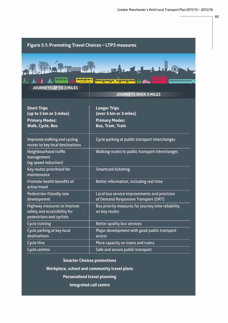
60
Greater Manchester’s third Local Transport Plan 2011/12 – 2015/16

61
Greater Manchester’s third Local Transport Plan 2011/12 – 2015/16
Smarter Choices
Smarter Choices are techniques to influence people's travel behaviour so that they make more use of sustainable modes. Examples include encouraging school, workplace, community and individualised travel planning; improving public transport (including improvements to information provision and ticketing); promotional / marketing activity such as travel awareness campaigns; supporting and promoting cycling and walking (including infrastructure improvements and cycle training for both adults and children); setting up websites for car share schemes; establishing car clubs and encouraging various forms of tele-working.
Smarter Choices strategies can help drive real modal shift, which is beneficial to health and reduces congestion. The potential benefits are clear: for example, the cost of treating the results of poor health from inactivity is around £50m a year across the conurbation16, while 55% of UK transport carbon emissions come from personal car use4. Improved health and reduced congestion can, in turn, help to support productivity and jobs, improve the region’s competitiveness and road network efficiencies, reduce worklessness, and cut carbon emissions. An additional benefit is that they provide a means of maximising the value and benefits of existing and planned investment, for example by attracting more passengers to use new infrastructure or by freeing up road space as a result of transferring some journeys to public transport. Smarter Choices techniques therefore have a central role to play in the delivery of the Greater Manchester Strategy.
The outcomes we plan to deliver through the use of Smarter Choices in combination with our other proposals are:
• a significant increase in the number of trips made by sustainable modes; • a long-term shift in travel behaviour across the city region as a whole; and • improved public health through the increased take-up of walking and cycling.
The main focus of our smarter choices work to date has been to develop and implement a range of travel plans; workplace, school, residential, council and area-wide, with particular emphasis on school travel plans. This follows the requirement in the Education and Inspections Act, 2006, for all local authorities to develop a Sustainable Modes of Travel Strategy, aimed at addressing the travel and transport needs of all children and young people in their area. The Government target of “all schools [having] a travel plan by April 2010” has now been achieved for almost all state primary and secondary schools (and a number of independent schools) in Greater Manchester. Therefore, the Greater Manchester authorities’ approach in these areas will be to ensure that we effectively monitor and maintain these travel plans.
This will allow the focus of development on Smarter Choices to prioritise access from residential areas to key destinations (jobs, schools, shops etc). We will also develop the potential for reducing the need to travel through promoting flexible working, tele-working, and improving access to local services. This will be supported through the Greater Manchester Spatial Framework which will encourage high trip generating development in town centres and other locations that can be served by public transport; and through local planning policies that encourage residential areas, which are designed to give priority to walking, cycling and public transport. Our approach will also recognise that Smarter Choices techniques are only effective when credible alternatives to the car exist.
16 Derived from Department of Health, 2009, data

62
Greater Manchester’s third Local Transport Plan 2011/12 – 2015/16
Therefore, initiatives and campaigns will particularly focus on areas where high quality public transport and/or high-quality infrastructure for cycling and walking are available or become available through the investment programmes presented in this Plan.
Consequently, our smarter choices programme will focus on supporting:
• journeys to work for which alternative modes are available; • local journeys near the home, for example to the local shops or schools; • journeys to local district centres, for example someone travelling from Horwich to Bolton, or
from Timperley to Altrincham; and • journeys to the regional centre and other key centres of employment and retail activity.
Case Study: Wigan Personalised Travel Planning The chief aims were to encourage a switch from car-based trips in the Standish area to more walking, cycling and public transport trips and to also increase general awareness of sustainable travel options. This project was designed to support infrastructure and smarter choices measures delivered along the A49 Standish to Wigan corridor and borough wide funded by the LTP capital programme. Participants were targeted recruitment using census and journey to work data on car ownership and accessibility and recruitment undertaken via: events, local press, online and postal surveys. The targeting of Local Authority, Hospital, and College staff, schools, libraries, churches other local businesses and community groups ensured engagement with 10,000 households with 2,000 individuals recruited. Personalised Travel Plan Packs were produced based on recruitment survey responses. Packs contain personal journey plans, sustainable travel information- maps, timetables and incentives e.g. bus tickets, cycle shop vouchers, and pedometers. The creation of innovative “web scraper” tool automated the personal journey planning process reducing the time from recruitment survey to pack delivery. Personalised Travel Plan packs were produced working in partnership with NHS, local cycle shops, bus and rail operators, Greater Manchester Passenger Transport Executive and neighbouring local highway authority Lancashire County Council. Evaluation postal, online and phone surveys were carried out at 2-3 weeks, 3 months and 1 year. Phases 1 and 2, carried out between 2009 and 2011, were funded via DfT Congestion Performance funding for congestion Monitoring Corridors match funded by the LTP capital programme. The first year evaluation showed:
• 17% reduction in the number of single occupancy car trips for travel to work • 8% reduction in the volume of car trips to school • 48% and 39% of respondents stated they are walking and cycling more for leisure or
shopping trips, respectively • 78% said that their awareness of sustainable travel options was now ‘very good’ or ‘good’,
compared to 40% at the recruitment stage. Quotations from participants “I want to lose weight, so I enjoyed all the walking information. I go for walks with park rangers now.” “Detailed information and very pleased to receive it.” “Really impressed, great and handy to have.” “Very happy with all the evaluations and the way you have kept track of everything and in contact.”

63
Greater Manchester’s third Local Transport Plan 2011/12 – 2015/16
For these journey types, the focus will be to deliver a coordinated approach covering all modes and a suite of smarter choices tools will be used to do this. Examples of the type of tools available include:
• marketing and communications; • research to identifying barriers and gaps preventing people using public transport and use of
customer feedback to deliver improved travel service; • personalised travel information and “door-to-door” journey information; • local travel awareness campaigns, education and training; • public information events (eg ‘walk to Work Week); • promotional activity to support investment in cycle access focussed on increasing cycling to
town centres and other local public transport interchanges; • delivering packages of small measures around local bus, train and tram stations to make them
more accessible by all modes of travel; and • travel strategies (travel plans) for specific places eg workplaces and schools. In the longer term we aim to deliver co-ordinated ‘smart’ travel information and promotion across all travel modes (public transport, road, active travel and freight), through the optimum channels and media and a smart ticketing system to support smart personal and commercial travel decisions across Greater Manchester.
Experience from areas at the forefront of using smarter choices techniques to change travel behaviour, eg the Cycling Demonstration Towns, Sustainable Travel Cities and Transport for London shows that Smarter Choices requires a comprehensive approach, from raising awareness of travel choices, through effective marketing, to securing the long-term commitment of travellers to new travel patterns through improved quality and reliability of transport services.
This is the approach we intend to adopt, but the scale of our ambitions is not currently matched by the funding available and the rate at which we can progress will depend on gaining access to additional funding, particularly revenue funding for ongoing promotional activity. We therefore intend to submit a comprehensive bid to the Local Sustainable Transport Fund (LSTF), both to kickstart a number of early initiatives and to provide a platform for the longer term maintenance of smarter travel programmes in Greater Manchester.
.


65
Greater Manchester’s third Local Transport Plan 2011/12 – 2015/16
6. Public Transport 6.1. Better Buses for Greater Manchester
After a long period of decline, bus patronage in Greater Manchester has shown a slight increase in recent years, as shown in Figure 6.1 below.
Figure 6.1: Bus Passenger Journeys
Source DfT Transport Statistics Bulletin 2005
However, whilst there has been significant growth on some corridors (where the Quality Bus Corridor programme has brought about improvements in reliability, journey times and passenger facilities and vehicle quality and the introduction of the National Concessionary Travel Scheme has boosted concessionary travel, the situation elsewhere has been less promising. In the short term, the economic situation means that it may be difficult to sustain patronage levels. In the longer term, as the economic situation improves, the bus network as a whole will need to attract significantly more passengers if we are to achieve our aim of economic growth without additional congestion and will need to better connect communities to work and education if people are to benefit from that economic growth. To achieve this we need to bring more of the network up to the standard of the best performing corridors. In response to passenger concerns about the punctuality and reliability of services (including the need to be kept informed about any delays or disruptions), the low service frequencies at certain times, the affordability of fares and issues of safety and security when travelling or waiting, we need to improve the quality of bus services by:
• improving the punctuality, reliability and regularity of services;
• improving the quality of service provided (in terms of vehicle cleanliness, emissions, accessibility and driver behaviour);

66
Greater Manchester’s third Local Transport Plan 2011/12 – 2015/16
• improving operating conditions for buses (eg through bus priority measures, better enforcement of illegal parking);
• improving passenger convenience and experience (eg through bus stop upgrades, smartcard ticketing, real time information); and
• improving network coverage, to improve links to areas of economic activity and improve social inclusion by strengthening evening and Sunday services.
Affordability can also be a significant issue for some people, but like most of the UK outside London, commercial (i.e. non-concessionary) bus fares in Greater Manchester are determined by private operators.
The achievement of the last few years in maintaining the level of bus patronage in Greater Manchester in the face of a long-term downward trend, has been as a result of working in partnership with the bus operators. We therefore want to build on this by achieving the above objectives through agreement, using powers provided by the Local Transport Act, 2008, covering tendering, Voluntary Agreements and Quality Partnership Schemes.
Improving service and vehicle quality In September 2010, GMPTE launched a Code of Conduct for bus operators. This is a Voluntary Partnership, establishing minimum service and vehicle standards (and targets for improvement) and committing operators to maintain agreed vehicle and driver standards and to participate in countywide ticketing arrangements. Although the code is voluntary, overall operator performance will be published regularly and a failure to meet standards could ultimately result in an operator being removed as a code signatory, with the attendant negative publicity. By January 2011, all the major operators and a number of smaller ones had ‘signed up’ to the Code, covering 84% of the network. Discussions continue with other bus operators who have indicated a desire to become signatories.
It is intended that the Code of Conduct will drive improved quality in four areas: • the vast majority of timetabled services should start their journeys on time;
• frequent services should have more even gaps between buses;
• passenger satisfaction should improve as operators pay more attention to cleaning, provision of passenger information, driver attitude and more careful driving behaviour; and
• newer vehicles should be introduced more quickly.
In addition to the Code of Conduct, we will develop Statutory Quality Partnership Schemes (QPS) initially for the Hazel Grove to Manchester and Leigh to Bolton corridors. On these corridors, recent investment in bus priority measures and improved waiting facilities through the Quality Bus Corridor (QBC) programme has provided operational benefits for operators. The QPS, which will last for up to ten years, will specify service and vehicle standards that the operators must meet in return for using these facilities (which the relevant highway authorities will agree to keep in place). A separate Voluntary Partnership Agreement would also see Transport for Greater Manchester and the highway authorities agreeing to certain maintenance standards and enforcement activity.

67
Greater Manchester’s third Local Transport Plan 2011/12 – 2015/16
Following on from the initial QPS on the Hazel Grove to Manchester and Leigh-Bolton routes, we intend to extend QPS gradually across a network of high frequency bus corridors.
Case Study: A6 Congestion along the A6 in Stockport in the peak periods affects the journey times of all vehicles and especially the reliability of buses. It is considered to be an issue by the public and is a priority for Stockport Council. There was a need, as part of the Greater Manchester Quality Bus Corridor project, to reduce congestion, improve network efficiency/reliability, improve bus performance and encourage modal shift, whilst providing for the needs of all road users including pedestrians. During 2007, GMPTE and Stockport, with the support of Greater Manchester Urban Traffic Control and Stagecoach, tested ‘bus gating’ in Hazel Grove. This scheme uses traffic signal timings to prevent too much traffic entering Hazel Grove in the morning peak to allow the A6 to run clear heading north to Stockport Town Centre. These ‘gates’ at two feeder junctions are opened only for a short time to allow a controlled volume of traffic to pass. Bus journey times reduced by just over three minutes between the ‘gates’ and J Sainsbury at Hazel Grove, but increased elsewhere because of increased delays at a number of junctions. Further work has been undertaken since 2009 to deal with factors contributing to congestion in, and north of, Hazel Grove, using a combination of local resources and DfT’s Congestion Performance Fund. By 2011/12, 12 schemes will have been completed. These include:
• junction and lane capacity improvement schemes; • traffic signals equipment and programming; • pedestrian safety schemes; • improving traffic management; • assistance to cyclists; and • reducing carriageway obstructions by removing parked vehicles e.g. by use of new
parking bays, waiting and loading restrictions. The proportion car trips to Stockport Town Centre in the morning peak fell from 67% in 2003 to 58% in 2009 (Source: GMTU report 1587). At the same time there is also evidence that average journey time along the A6 has decreased since 2006. Average Journey time, minutes per mile for car and bus users along A6, Congestion Route 7 2006-07
(Sept-Aug) 2007-08 2008-09 2009-10
A6 Buxton Road / B6171 Nangreave Road – A6 Wellington Road / A5102 Bramhall lane
07:11
05:57
05:52
05:55
Source: GMTU March 2011

68
Greater Manchester’s third Local Transport Plan 2011/12 – 2015/16
We will continue to work in partnership with bus operators to secure fleet replacement programmes more quickly than might have otherwise occurred. In addition we will take advantage of opportunities to bid for funding to accelerate the rate at which new vehicles are introduced. As well as benefits to passengers and the environment, there can be financial benefits in buying vehicles for use on tendered services, since providing a vehicle for use on a service contract widens the market of interested operators and brings future cost savings through reduced tender prices (since the operator does not have to allow for vehicle costs). Most recently, GMPTE, a number of operators and Manchester Airport Group made successful bids to the DfT Green Bus Fund. This funding is available to support a proportion of the additional costs of buying vehicles that are capable of achieving at least a 30% reduction in greenhouse gas emissions compared to a similar-sized standard diesel Euro III bus. As a result over 150 new electric-hybrid vehicles will be brought into operation in Greater Manchester in the next few years. The GMPTE vehicles (now Transport for Greater Manchester) will be used on Metroshuttle services, extending the Yellow School Bus fleet and on general subsidised service contracts. As funding becomes available, we plan to add to the fleet of Yellow School Buses, which have been successful in reducing car use on the journey to and from school by providing a reliable alternative and reducing anti-social behaviour. The buses have also been shown to reduce truancy rates among pupils. In the longer term we will also be looking to develop new partnership approaches to bring about improvements in the areas of fares, frequencies and timings. However, if these approaches do not secure the required levels of improvement we would consider implementing appropriate Quality Contract Schemes where operators would bid to run a specified network, as is the case in London.
Improving operating conditions for buses Heavy traffic, roadworks and incidents on the highway network all affect the punctuality and reliability of bus services. By introducing a level of bus priority, through bus lanes, signal timings and improvements for buses at junctions, our QBCs have improved punctuality, reduced the gap between car and bus journey times and reduced the variability of journey times. There is, however, the danger that these benefits will be eroded over time as traffic levels rise, so we need to maintain the comparative advantage of buses on these corridors and ensure that bus lanes and parking restrictions are backed up with effective enforcement (see section 6.1). We will also ensure that the infrastructure itself (lane markings, coloured surfacing, paving, bus stops and shelters) is well maintained.
Despite the QBC programme, there are still numerous ‘hotspots’ on the network where buses are delayed. As funding permits, we will therefore introduce measures to address local congestion hotspots, and pinch points where buses are delayed. Given the funding situation, we will prioritise improvements that will improve access to employment and support town centre regeneration, and have been evidenced through the surveys of service punctuality and reliability that are undertaken as part of our Bus Partnership monitoring.
A further source of delay for services is the payment of cash fares on the bus, which can significantly increase the ‘dwell time’ at bus stops. Ironically, as more passengers are attracted to use buses as a result of improved reliability and quality of service, this problem can become worse and can reduce

69
Greater Manchester’s third Local Transport Plan 2011/12 – 2015/16
the benefit of bus priority measures. Our proposals for introducing Smartcard ticketing are described in section 6.4.
Elsewhere (section 8.1) we describe our proposals for the development of a strategic highway network management system. This will ensure that key routes to significant centres of economic activity, such as town and city centres, the Airport and Trafford Park are managed and maintained to improve reliability for all users, including bus passengers and, where appropriate, give priority to particular user groups. It will also ensure that we develop a joint approach with the Local Economic Partnership to deal with the worst congestion hotspots. Our approach will include strategic traffic management for road works, developers’ works and major events, which can cause significant delays. Figure 6.2 shows the core bus network which forms part of the strategic highway network management system.
Figure 6.2: Core bus network:
Building on the QBC concept, we are planning to introduce two further substantive bus priority schemes in the next five years, namely: the Cross City Bus Package and the Leigh-Salford-Manchester Busway.
Cross City Bus The Cross City Bus Package, which is subject to Department for Transport funding approval, will bring significant improvements for passengers. Most bus services to Manchester currently terminate in the city centre, with passengers having to change buses to reach destinations on the other side of the city. The Cross City Bus Package involves providing direct linkage between three major bus

70
Greater Manchester’s third Local Transport Plan 2011/12 – 2015/16
corridors (from the north, west and south of the conurbation) across Manchester city centre by introducing bus priority to improve reliability, particularly in the city centre, thus enabling the introduction of reliable through-services. This will enable through-journeys, improve access to the universities and hospitals located on Oxford Road/ Wilmslow Road in the city, reduce bus journey times and improve reliability. The Oxford Road Corridor is the location of the Hospital and the Higher Education Precinct (HEP) and is a significant economic centre which currently includes around 4% of the city’s total business stock. The number of jobs provided in the Oxford Road corridor is expected to grow from 36,000 jobs in 2008 to over 55,000 jobs by 2020. The scheme will enhance public transport links between areas of deprivation to the North and West of Manchester with new and existing job opportunities, education facilities and health services on the Oxford Road Corridor in South Manchester. The Corridor has recently strengthened its role as the key location for health care provision within the conurbation bringing further jobs as well as additional visits for health related purposes. The cross city scheme will support the economic development of the city centre by removing through-traffic from the pedestrian priority core and will bring significant improvements for pedestrians and cyclists. Leigh-Salford-Manchester Busway The Leigh Salford Manchester Busway will significantly improve journey times between Leigh and Manchester, reducing the travelling time between Leigh and Manchester City Centre by 30%). This will be achieved by creating a 7km (4.3 mile) stretch of segregated busway between Ellenbrook and Leigh, along a disused railway line and introducing on-highway bus priority measures between Salford and Manchester, linking with the Cross City scheme described above. By using dedicated high quality vehicles, the scheme will bring the benefits of rapid transit to a number of communities along this important public transport corridor, eg Astley and Tyldesley. The scheme is estimated to have a ‘walk in’ catchment of 30,000 households, of which around 24% have no access to a car.
In the longer term we plan to develop other proposals for further bus transit or express bus corridors as part of a wider rapid transit strategy, described in Section 6.2.

71
Greater Manchester’s third Local Transport Plan 2011/12 – 2015/16
Case Study: Cross City Bus Package Transport for Greater Manchester, working in partnership with Manchester, Salford and Rochdale Councils, has developed a series of Cross-City Bus proposals aimed at improving transport connections along three of Greater Manchester’s busiest roads through Manchester City Centre. The scheme, in conjunction with other elements of the Greater Manchester Transport Fund Programme, will provide bus priority infrastructure that supports the creation of three direct bus routes, from: • Leigh and Atherton, to the west of Manchester (with additional connecting services from
Wigan) to the MRI on Oxford Road via the A580, Salford Central and the Regional Centre; • Middleton Bus Station to the North of Manchester to the MRI on Oxford Road via Rochdale
Road and the Regional Centre; and • Parrs Wood in South Manchester to Pendleton on the A580 corridor, via Oxford Road and
the Regional Centre. The types of measures that will be implemented on the corridors include: • dedicated bus lanes and bus-only sections of route; • formalised parking arrangements; • carriageway widening/narrowing; • geometric signal design/redesign; • bus stop upgrades; • side road closures; • movement restrictions at junctions; • loading and waiting restrictions; • pre-signalisation and signal priority for buses; and • enhanced pedestrian crossing facilities. The Cross City Bus Package scheme network will enhance the existing Greater Manchester Quality Bus Corridor (QBC) network and address the unique problems of the Oxford Road corridor, which has the highest demand for bus travel in Greater Manchester, yet has the poorest results in terms of bus performance. The primary objectives of the Cross City Bus Package Scheme, in conjunction with other elements of the Greater Manchester Transport Fund Programme, are to: • increase accessibility from areas of social depravation along the A580 and A664 corridors to
the Regional centre, Oxford Road employment growth centre; healthcare facilities, education opportunities, shops, leisure and other key facilities along the corridors, thereby contributing to additional jobs and improved economic productivity;
• reduce bus journey times and improve punctuality and reliability; • minimise the carbon impact of transport growth, predicted to be 5,000 extra morning peak
bus journeys into the Regional Centre by 2020; and • reduce accidents.

72
Greater Manchester’s third Local Transport Plan 2011/12 – 2015/16
Improving passenger convenience In the last ten years, we have introduced new, high quality bus stations into a number of our town centres including Oldham, Middleton, Eccles, and Hyde and at Shudehill, in Manchester city centre. These give greater levels of passenger convenience, comfort and security by providing a central passenger concourse, which can be designed to complement the town centre.
We now plan to build major new interchanges at:
• Altrincham (bus/rail/Metrolink), funded through GMTF; • Bolton (bus/rail), funded through GMTF; • Rochdale (bus/Metrolink), awaiting Department for Transport funding; and • Wythenshawe, funded by Transport for Greater Manchester and Manchester City Council.
We will also develop plans for a new interchange at Stockport, along with a related package of measures to improve access to it. All the above schemes will make connections between different public transport modes easier and are central to ambitious town centre regeneration plans. As funding allows, we will seek to bring forward other interchange improvements. Under the Disability Discrimination Act (DDA), new buses must be accessible by 2017. To maximise the benefits of this change bus stop kerbs need to be raised to give easy access onto low floor vehicles. This work has already been completed on the QBCs. We will continue to upgrade bus stops to improve physical accessibility, comfort (eg providing shelters) and personal safety (eg improving lighting), but the rate at which we can do this will depend on the level of funding available and we will develop a prioritised programme. We will also take opportunities to use developer funding where new development will increase the usage of a bus stop.
We will also develop proposals for simpler fares and ticketing arrangements, linked to our proposals for smartcard ticketing, and for better and easier-to-use passenger information systems. This is discussed in more detail in section 6.5. Future employment growth in Manchester City Centre will require a growth in bus patronage if road traffic is to be kept to current levels. In the short term, there will be limited funding available to develop additional interchanges and so the use of existing facilities will be optimised. In the longer term, the plan is for a phased re-location of on-street stops into interchanges. Plans to extend pedestrian priority and improve public realm in some areas will require a new routing strategy in the central area, that still allows passengers to access employment, education/training, shopping and leisure destinations.

73
Greater Manchester’s third Local Transport Plan 2011/12 – 2015/16
Improving network coverage Greater Manchester has an extensive public transport network, with most residents having public transport access to a local centre that provides key retail, health and public services. However, levels of bus service decline away from the main routes, leaving rural areas and some estates with limited alternatives to the car, particularly in the evenings and at weekends. In addition some key employment areas, such as Trafford Park are difficult to access by bus, either because of a lack of services or due to lengthy journey times. Changes such as the introduction of Sunday trading, ‘out of town’ developments and the re-organisation and consolidation of key services (for example, in the health sector), have changed travel patterns and the bus network has not always been able to respond. In the future, increased levels of part-time and shift working will place further demands on the network. Where bus services can not be provided commercially, such as in rural areas and the more isolated housing estates, Transport for Greater Manchester is able to provide tendered services to meet social needs, including ‘demand responsive’ services (see below) where demand is very low, but budgetary constraints mean that it will never be possible to provide all the desired bus services.
We have recently reviewed the bus network with the aim of removing duplication, creating more even intervals between buses, improving integration between services, improving access to areas of economic activity, and serving areas with un-met transport needs. As a result, we have developed a ‘Target Bus Network’ which better supports the pattern of development in Greater Manchester, improves links to areas of economic activity and strengthens services in the evenings and on Sundays. We will use this target network to help shape changes to the commercial bus network, in agreement with bus operators, focusing on changes that improve access to areas of economic activity, to support people getting back to work. As the economic climate improves we will also look to extend the coverage of services in the evenings and on Sundays to reduce the isolation of people who do not have access to a car.
Most bus services operate on radial routes into town and city centres, and as a result, many ‘orbital’ journeys, across the urban area can only be made by changing buses in town centres. We will look at whether additional orbital bus routes could better meet peoples’ travel needs and help to meet our wider objectives eg improving access to employment. Connections across town centres have been improved by the introduction of free Metroshuttle services in Manchester, Bolton and Stockport; we will investigate the potential to introduce these in other town centres. Although the lack of resources will limit our ability to do this in the short term, we will seek opportunities do so, eg through third-party funding.
In areas of low demand, it is difficult to justify a conventional bus service. Transport for Greater Manchester therefore provides a number of ‘demand responsive’ services, which help to fill gaps in the network. We need to keep the requirement for demand responsive services under review so that they complement new approaches to traditional bus service provision as they are implemented during the lifetime of this Plan. Our approach to demand responsive transport, including taxis, private hire and community transport is described in the Door-to-Door Transport section below.
We will continue to work in partnership with the bus industry to secure the level of bus services that will meet community needs, particularly in providing access to work, healthcare and to education. Whilst it will be possible to make some changes to the existing network, either by operators agreeing to alter commercial services or by making changes to the network of supported bus

74
Greater Manchester’s third Local Transport Plan 2011/12 – 2015/16
services, we recognise that short term funding pressures, together with rising bus industry costs will constrain the ability to achieve this. We believe that we need to target local and national public financial support for bus services in the most effective way to achieve the fares and service level that will give maximum value to both passengers and the taxpayer. We will work with bus operators and the Department for Transport to develop new approaches, which may require primary legislation, to the delivery of local bus services that better reflect the balance of public financial support and commercial risk. In the event that we are not able to bring forward such alternative delivery mechanisms, we will consider using existing legislation to introduce a Quality Contract Scheme. Coaches Coach services provide cost effective long distance travel and are particularly popular with students and older people. They are also vital to tourism and the visitor market in the conurbation eg for events and shows. Many services are focused on the Central Manchester Coach Station, but individual local authorities will work with operators to ensure that there is adequate signing to suitable coach parking locations and that coaches can pick up or set down close to their destinations. We will also work with operators to examine the scope for express buses or coaches to operate on long distance corridors, especially where there are no rail services or where parallel rail routes are overcrowded and highway (such as motorway) routes are congested. Water Taxis
Greater Manchester’s network of canals offers traffic-free routes through the conurbation. Private sector operators have expressed an interest in running water taxi services between Manchester city centre and Salford Quays/the Trafford Centre. We will work with the private sector to identify the role that water taxis might play as part of Greater Manchester’s transport offer, for leisure and commuting trips.

75
Greater Manchester’s third Local Transport Plan 2011/12 – 2015/16
6.2 Door-to Door Transport Door-to-door transport is an important component of the transport network. It includes taxis and private hire vehicles, community transport, demand responsive transport and specialist services such as Ring and Ride. Whilst door-to-door transport is vital for people who are not able to drive or to use conventional public transport, or who have no bus service available, it is also used by many more people because of its convenience.
The growing number of older people in the population are likely to have higher expectations in terms of accessibility (since many will have been car drivers), and the ease with which they can start and end journeys will be a significant factor that determines whether they use public transport. For people in their 80s and above, door-to-door transport will be vital in helping them to make journeys.
Door-to-door transport also has the potential to improve local accessibility, particularly linking communities with jobs, in areas where public transport does not provide these links. It can, therefore, play a role in increasing productivity in the conurbation.
Taxis and Private Hires Taxis are vital to the functioning of the conurbation, providing:
• an alternative to the private car for those who do not own one; • support for the night-time economy (when people wish to leave their car at home); • the final ‘leg’ of a public transport journey; or • a backup mode when other arrangements fail.
In addition to conventional hackney cab and private hire services, taxis are used by Transport for Greater Manchester to provide ‘demand responsive transport’ services in some areas where the demand is too low for a bus service (see below).
In recognition of their role in supplementing the public transport network, hackney cabs are permitted to use ‘with-flow’ bus lanes throughout Greater Manchester, since they can be easily distinguished from private cars. However, this can not be extended to private hire vehicles because there is such variation in their appearance and no common feature exists to distinguish them from private cars.
The issue of licences for hackney cabs is controlled by each of the ten local Licensing authorities, who also determine the location of taxi ranks. Each authority sets its own standards eg for the number of licenses issued, the age of vehicles and the area in which they can operate.
Our long term aim is to achieve more consistency across Greater Manchester in order to provide a better, more integrated service for the public. We will work with Licensing Authorities, taxi and private hire operators to bring this about, building on best practice from elsewhere.
Community Transport Recognising the potential of community transport to provide local services to communities in areas of low demand, GMPTE and the Community Transport Association (CTA) established the Greater Manchester Community Transport Forum (GMCTF) to encourage best practice among community transport operators and build their capacity to bid for contracts and deliver DRT services.

76
Greater Manchester’s third Local Transport Plan 2011/12 – 2015/16
As a result, in 2009/10, the 10 community transport operators in Greater Manchester secured over £1.1 million in contracts from GMPTE alone as well as winning over £390,000 in European funding. In the same year, the sector provided nearly 840,000 passenger trips to Greater Manchester residents (and covered 3.6 million kilometres in doing so17*), saving an estimated 40,000 car journeys.
Other recent developments have included the establishment of a Quality Framework, which is an annual monitoring and evaluation tool and includes a web-based Vehicle Management System (VMS) that is compliant with Vehicle and Operator Services Agency (VOSA) legislation. Volunteer driver schemes have also been established in partnership with Primary Care Trusts and social service departments.
We will continue to support and work with the community transport sector, and this relationship is likely to become more important as part of the empowerment of communities.
Demand Responsive Transport (DRT) Transport for Greater Manchester has 28 DRT services operating throughout Greater Manchester. These provide pre-booked journeys, picking passengers up from home and taking them to key local destinations. DRT is a planned response to gaps within the current public transport networks. DRT services operate throughout the day and evening in some of the most geographical and economically disadvantaged communities, enabling local residents to access key destinations such as employment, health, education and leisure and cultural activities.
Initially, DRT was operated mainly by community transport services; however, private hire taxis now operate almost 50% of the DRT services in Greater Manchester. As with community transport operators, we have established good links with private hire taxi organisations in Greater Manchester to provide training programmes (such as tender training).
We will seek opportunities to draw on third-party funding for specific DRT projects to improve accessibility, for example the Department of Health funded ‘Partnerships for Older People Project’ (POPP) through which we have provided flexible transport to healthcare, shopping and social opportunities in Rochdale. We will also continue to seek developer contributions as a way of improving access to new developments.
Ring and Ride Operating for over 25 years, Ring and Ride is a door-to-door service operated by Greater Manchester Accessible Transport Limited (GMATL). Unlike DRT, which is for all passengers living in an agreed geographical area, Ring and Ride is exclusively for disabled and older passengers and for those passengers who find it difficult to access public transport. Grant funded by the Greater Manchester Combined Authority, the Ring and Ride service operates 81 fully accessible minibuses throughout Greater Manchester, carrying over 1.1 million passengers each year.
17 Transport for Communities data, 2010

77
Greater Manchester’s third Local Transport Plan 2011/12 – 2015/16
Integration of Door-to-Door Services A call centre, utilising the latest technology, books and schedules DRT services and the Ring and Ride Manchester and Stockport services. This will eventually cover Ring and Ride throughout the conurbation. Not only is this the most effective way of scheduling door to door services, deploying buses in the most efficient way, the system also allows for web booking and eventually SMS text messaging. The same system also hosts scheduling software used for adult services in Tameside and Wigan. This collaboration between Greater Manchester authorities has allowed the development of a model for expanding the use of booking and scheduling services in a way that will realise efficiencies for participating authorities and promote the shared use of ‘backroom’ services. There are currently a number of agencies who provide some kind of demand responsive service (community transport, DRT, Ring and Ride, taxi, social services, education and NHS patient transfer services) and there is scope to better co-ordinate these so as to use vehicles and staff more efficiently. Our aim is for all door-to-door services to be booked via a one-stop call centre available to statutory organisations, voluntary groups and residents of Greater Manchester. This would not only be cost effective (as the increased number of trips that can be delivered reduces the unit cost) but would provide an improved offer to individual passengers as well as those in receipt of personalised budgets via social services departments. Case Study – Integrated Social Needs Transport (ISNT) ISNT has employed innovative collaborative techniques with multiple partners to improve transport and mobility outcomes, including journeys for children with special needs or adults in receipt of care packages, through increasing efficiencies in demand responsive transport services. The project has also housed and led an EU supported Interreg Project (Improving Connectivity and Mobility Access – ICMA) to achieve best practice in respect of the delivery of effective ‘first and last miles’ transport solutions. Improvements include the integration of booking and scheduling technology (developed in conjunction with GMATL who operate Ring and Ride services), passenger responses and fleet resources, together with the development of a model to facilitate the migration of scheduling services for local authority and other statutory agencies. This has been deployed in Wigan and Tameside and can also be rolled out further to accommodate other agencies. Further improvements (funded by ERDF through the ICMA Project) have been made to address additional demand and include a web booking facility. This is of particular help to those using the services for work. The IT system has enabled cross-sector support in a Shared Technology Project supported by AGMA’s Collaborative Efficiency Programme Office. Current challenges include: • relocation of the Scheduling Centre following a period of growth leading to capacity issues; • further promotion and development of web-based booking; • further service quality improvements for DRT services, including greater use of text and voice
messaging to update users on relevant operational issues such as late running; and • additional work with local authorities, inside Greater Manchester and further afield, to develop a
sustainable business model for expanding collaborative work linked to booking and scheduling transport services

78
Greater Manchester’s third Local Transport Plan 2011/12 – 2015/16
Successes include: • support for the expansion of the DRT service base delivered by Community Transport operators
from 8 to 16 services by 2010; • increase in booking and scheduling activity to 30000 bookings per month by 2010; • shared use of Scheduling Centre services by 4 organisations; and • reported expected efficiency savings in excess of £150,000 per annum. Quotes from DRT service users: “The service is always on time which is really useful as I am often going to the doctor’s.” “I always find the drivers friendly but it can take a long time to get through to book. I am very happy with the service.” Extract from Officer report on Salford DRT following on board interviews: ‘A lot of the passengers seemed to know each other from using the service and there was a good community atmosphere. The service is very valuable to those who use it and they conversed aside from me with each other about how valuable the service was. The driver also told me about regular passengers who go shopping but do not seem to buy anything and he felt the service provided a good method of social interaction for some people’.
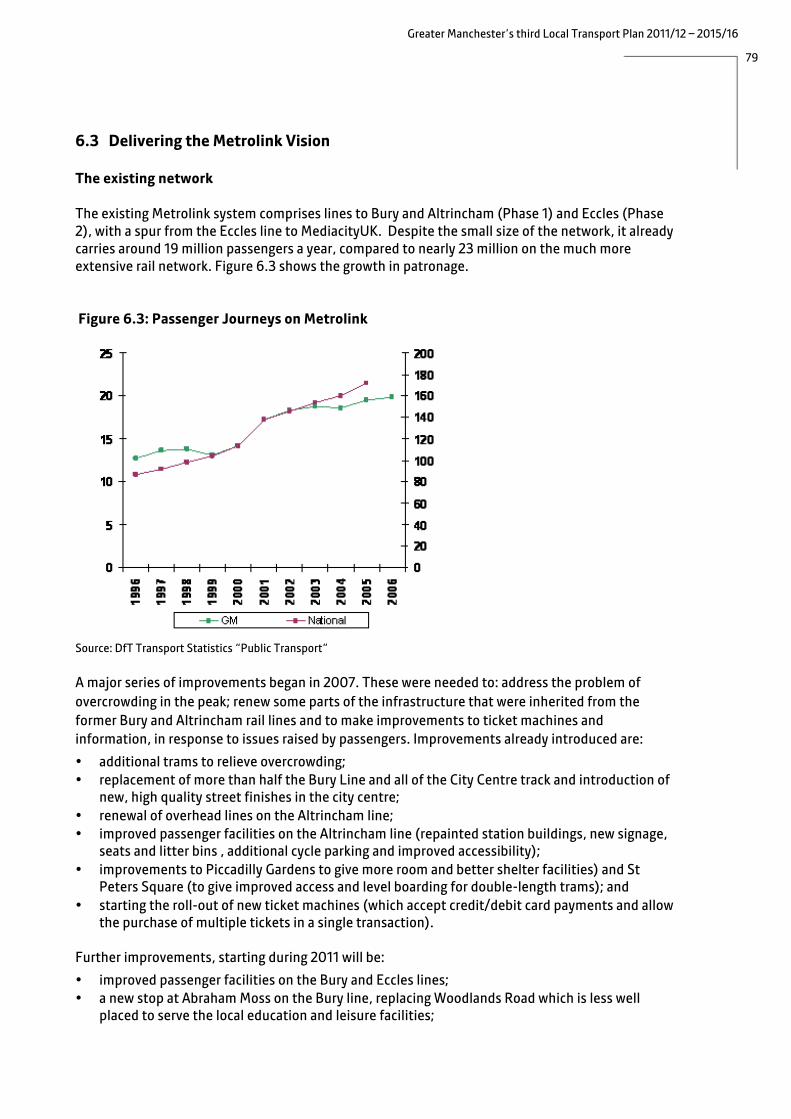
79
Greater Manchester’s third Local Transport Plan 2011/12 – 2015/16
6.3 Delivering the Metrolink Vision The existing network The existing Metrolink system comprises lines to Bury and Altrincham (Phase 1) and Eccles (Phase 2), with a spur from the Eccles line to MediacityUK. Despite the small size of the network, it already carries around 19 million passengers a year, compared to nearly 23 million on the much more extensive rail network. Figure 6.3 shows the growth in patronage. Figure 6.3: Passenger Journeys on Metrolink
Source: DfT Transport Statistics “Public Transport”
A major series of improvements began in 2007. These were needed to: address the problem of overcrowding in the peak; renew some parts of the infrastructure that were inherited from the former Bury and Altrincham rail lines and to make improvements to ticket machines and information, in response to issues raised by passengers. Improvements already introduced are:
• additional trams to relieve overcrowding; • replacement of more than half the Bury Line and all of the City Centre track and introduction of
new, high quality street finishes in the city centre; • renewal of overhead lines on the Altrincham line; • improved passenger facilities on the Altrincham line (repainted station buildings, new signage,
seats and litter bins , additional cycle parking and improved accessibility); • improvements to Piccadilly Gardens to give more room and better shelter facilities) and St
Peters Square (to give improved access and level boarding for double-length trams); and • starting the roll-out of new ticket machines (which accept credit/debit card payments and allow
the purchase of multiple tickets in a single transaction).
Further improvements, starting during 2011 will be:
• improved passenger facilities on the Bury and Eccles lines; • a new stop at Abraham Moss on the Bury line, replacing Woodlands Road which is less well
placed to serve the local education and leisure facilities;

80
Greater Manchester’s third Local Transport Plan 2011/12 – 2015/16
• subject to funding, a new Bury line stop at Queens Road (which is currently a stop for the depot only), to serve the Collyhurst Housing Market Renewal Area;
• closure of the Mosley Street stop to improve the flow of trams through Manchester City centre once the network is extended; and
• new passenger information screens, providing real time information at each stop. Extending the network Proposals to expand the network have been central to our transport strategy for many years, underpinning the first two Local Transport Plans produced in 2001 and 2006. The importance of an expanded network to Greater Manchester lies in the benefit to the economy, through improved connectivity of the labour market, reduced congestion and the regeneration of town centres and communities along the route.
In 2010, services commenced on a short spur from the Eccles line to MediaCityUK, funded by the North West Regional Development Agency. MediacityUK is a nationally significant new home for creative, digital and media businesses and the main tenant will be the BBC, who will have over 2500 employees based there by 2011.
Funding to build new lines to Oldham and Rochdale, Ashton-under-Lyne and Manchester Airport (Phase 3) was granted by Department for Transport (DfT) in March 2000, but subsequently withdrawn in July 2004 due to concerns regarding the cost of light rail procurement nationally. Following a determined local campaign to keep the scheme alive, a ministerial working group was set up with DfT to find a way forward and the Government subsequently confirmed that the £520 million funding originally offered was still available for Metrolink expansion via the Regional Funding Allocation.
In April 2005, the Greater Manchester Integrated Transport Strategy reaffirmed Metrolink, set in a multi-modal context and supported by behavioural change strategies, as the best solution for the Oldham/Rochdale, Ashton and South Manchester/Airport corridors. As a result of a revised procurement strategy and detailed appraisal, the South Manchester/Airport route was modified so that only the eastern section of the circular loop through Wythenshawe to the Airport was included in the scheme. However, the powers that would enable future development of the western loop have been retained, since improving transport links to Wythenshawe hospital remains a high priority. The intention is now to link the hospital to Metrolink via a shuttle bus. Completion of the Metrolink western section remains an aspiration but will have to await future development and funding opportunities.
The original plans for Phase 3 to Oldham/Rochdale, Ashton-under-Lyne and Manchester Airport were split into two phases: Phase 3a being those elements that could be funded using the available Government funding, and Phase 3b being those elements for which another funding source would be needed. On that basis we were able to proceed with Phase 3a, which comprises:
• the lines to Oldham and Rochdale using the existing heavy rail line (but excluding the new
sections going into the two town centres;
• part of the south Manchester line, as far as Chorlton; and
• part of the east Manchester line as far as Droylsden.

81
Greater Manchester’s third Local Transport Plan 2011/12 – 2015/16
In 2009, the Greater Manchester Transport Fund was established to bridge the funding gap between the total cost of a number of priority transport schemes and the level of funding available through the Regional Funding Allocation and other national transport funding initiatives. This is described in detail in section10.2. As a result of this fund, the balance of the funding for the Phase 3 Metrolink expansion is being provided locally, enabling all three lines to be delivered in full. Details of the new lines are set out below. By the end of 2012, four new lines (to Oldham/Rochdale, South, East Manchester and MediacityUK) will nearly double the size of the tram network, with 32 km (20 miles) of new track and 27 new stops. The effect will be to take 5 million car journeys off the road each year and increase the number of daily passenger trips from 55,000 to 90,000. The extensions to the Airport, Ashton-under-Lyne, Oldham and Rochdale town centres and East Didsbury will further add to this, to effectively treble the size of the existing network by 2016. Figure 6.4 shows the extent of the existing and planned Metrolink and rail networks in Greater Manchester.
Figure 6.4: Greater Manchester Metrolink and Rail Networks
82
Greater Manchester’s third Local Transport Plan 2011/12 – 2015/16
Oldham and Rochdale This 22.5 km (14 mile) extension to Oldham and Rochdale will join the Bury Metrolink line just outside the city centre and run along an abandoned railway corridor to Central Park in east Manchester. Here it will join the existing Oldham loop rail line between Manchester, Oldham and Rochdale, which is being converted to Metrolink. Stops (either new or as a result of upgrading existing stations) will be built at Monsall, Central Park, Newton Heath & Moston, Failsworth, Hollinwood, South Chadderton, Freehold, Oldham Mumps, Derker, Shaw & Crompton, Newhey, Milnrow, Kingsway (subject to confirmation of funding), Newbold and Rochdale Railway Station (on Maclure Road). As a result, Metrolink will serve key employment sites at Central Park, Hollinwood and Kingsway Business Park, as well as a number of Housing Market Renewal Area sites in Oldham and at Newton Heath. As a result of the Greater Manchester Transport Fund, the line will be further extended to Oldham and Rochdale town centres. New stops will be built in Oldham at Westwood, Oldham King Street and Oldham Central (Union Street). There will be an additional stop at the new transport interchange in Rochdale town centre. Completion dates are as follows: • Central Park: Spring 2011 • Oldham Mumps: Autumn 2011 • Rochdale: Spring 2012 • Oldham town centre: 2014 • Rochdale town centre: 2014
Case Study: Improving the connectivity of Oldham with Metrolink The former Manchester-Oldham-Rochdale heavy rail route is being converted to Metrolink and extended to penetrate Oldham and Rochdale town centres. It will link residents in areas historically poorly served by public transport with employment, retail and leisure destinations throughout the conurbation. The construction period will bring the following challenges: • The rail service ceased in October 2009 to enable conversion, causing the loss of a
valuable service where the bus alternatives are slower. • Highways have been disrupted as a consequence of these works – this is likely to get
significantly worse in Oldham town centre in the coming two years. The measures put in place to mitigate the impacts and to promote Metrolink include: A multidisciplinary team has been put together to mitigate any ill-effects from the construction works. • Extensive efforts will be made to provide correct, useful and timely information to
enable people plan around construction and disruption. • Information will be provided on a staged basis to enable people to take advantage of
the new transport links as they come on stream • Existing and prospective regeneration investors are being made fully aware of the
coming major new opportunities. Each new service will connect with the existing and new Greater Manchester – wide Metrolink services, using new trams to provide frequent, fast and reliable transport links. By 2014 there will be 20 stops on the Manchester – Oldham – Rochdale route and connections through to Manchester city centre, Altrincham, Ashton, Bury, Eccles and Media City, south Manchester and Rochdale. Manchester Airport will become available later. The Rochdale Interchange scheme (see section 6.1) is an essential improving connectivity in Rochdale town centre; providing a bus/Metrolink interchange in the heart of the town centre.

83
Greater Manchester’s third Local Transport Plan 2011/12 – 2015/16
South Manchester The 2.7 km (1.7 mile) extension to St Werburgh's Road in Chorlton will run south from Trafford Bar along a disused railway line with three new stops at Firswood, Chorlton and St Werburgh's Road. A new depot at Trafford Bar will provide capacity to house and maintain the expanded tram fleet. As a result of the Greater Manchester Transport Fund, the line will be further extended from St Werburgh’s Road to East Didsbury with additional stops at Withington, Burton Road, West Didsbury, Didsbury Village and East Didsbury, providing an effective alternative to the car on a congested corridor. Completion dates are as follows: • St Werburghs: Spring 2011 • East Didsbury: Summer 2013
Manchester Airport The line to Manchester Airport branches off from the South Manchester line at Chorlton. Additional stops will be built at Barlow Moor Road, Hardy Farm, Sale Water Park, Northern Moor, Wythenshawe Park, Moor Road, Baguley, Roundthorn, Martinscroft, Haveley, Benchill, Crossacres, Wythenshawe town centre, Robinswood Road, Peel Hall, Shadowmoss, Woodhouse Park and Manchester Airport. As well as improving access to the Airport for workers in the neighbouring residential areas, the line will serve regeneration areas in Wythenshawe town centre and improve access to recreational areas at Wythenshawe Park and Sale Water Park. The line also includes a strategic park and ride alongside the M60 at Sale Water Park.
Design and advance work started in 2010 and passenger services to the airport are expected to begin in 2016.
East Manchester The new 6.3 km (3.9 mile) extension to Droylsden in Tameside will run from Manchester Piccadilly through the heart of east Manchester. The line runs under Great Ancoats Street, through Holt Town and along Ashton New Road. The line will provide a link to the City of Manchester Stadium and the Velodrome and will have eight new stops at New Islington, Holt Town, Sportcity-Stadium, Sportcity-Velodrome, Clayton, Edge Lane, Cemetery Road and Droylsden.
As a result of the Greater Manchester Transport Fund, the line will be further extended from Droylsden to Ashton-under-Lyne with additional stops at Audenshaw, Ashton Moss, Ashton West and Ashton-under-Lyne. In addition to serving major leisure and sporting destinations and the Ashton Moss business park, the line will serve major Housing Market Renewal areas at New Islington and Holt Town and will support the regeneration of Ashton town centre. Completion dates are as follows: • Droylsden: Spring 2012 • Ashton-under-Lyne: Winter 2013/14

84
Greater Manchester’s third Local Transport Plan 2011/12 – 2015/16
Second City Crossing By the time the above new extensions are completed, the Greater Manchester tram network will be the largest in the UK, and there will be a significant increase in the numbers of trams passing through the city centre. This will increase the vulnerability of the central section to disruption eg due to incidents or breakdowns. We therefore plan to develop plans for a second Metrolink route across the city centre. The proposals form part of the wider transport strategy for Manchester city centre and will also be funded by the Greater Manchester Transport Fund.
A second Metrolink line across the city centre will provide:
• increased operational capacity; • improved reliability for all Metrolink services; • capacity to accommodate additional services beyond those currently committed and to extend
services from MediacityUK into the city centre without having to change trams; • flexibility to serve special events; and • reduced disruption caused by future maintenance and renewals (by providing a diversionary
route).
The new route will start at Manchester Central Convention Complex (Deansgate-Castlefield stop), run along Cross Street and Corporation Street to re-join the existing Metrolink line just outside Victoria Station.
Longer term plans Beyond the committed expansions to the Metrolink system described above, we have two key longer term priorities for extending the network: • an extension through Trafford Park, connecting with the Trafford Centre, the new City of Salford
Stadium and Port Salford; and • an extension to Stockport town centre. Extensions to Trafford Park and Stockport have long been an aspiration. Work is underway to review design and alignment options. In the case of Trafford Park, this involves developing proposals for an extension running through Trafford Park, connecting with the Trafford Centre, the City of Salford Stadium and Port Salford. This extension will provide greatly improved public transport to the largest concentration of employment outside the Regional Centre and we will work with partners to identify a delivery mechanism for the scheme. In the short term we will work to improve local connectivity by other non-car modes. Bringing Metrolink to Stockport will further improve accessibility to the town centre and support the anticipated growth associated with the Stockport town centre Masterplan. Work is underway to develop the optimal solutions that complement the wider strategic development of the town centre.
Clearly, given the current funding constraints, it may take some time before major investment in further new routes will be possible. However, planning will continue so that we can take advantage of any future funding opportunities and also plan new commercial and residential developments in tandem. We have identified a need to extend the benefits of Metrolink-style routes and services to more parts of Greater Manchester, making public transport more competitive with the car in terms of speed and expanding the labour market catchments of town and city centres. In addition to serving existing development, other corridors of long-term demand are emerging through work

85
Greater Manchester’s third Local Transport Plan 2011/12 – 2015/16
being undertaken in tandem with the developing Greater Manchester Spatial Framework (see section 3.2). Providing fast, frequent and attractive public transport services to more areas could involve increasing the capacity of the existing Metrolink system, new Metrolink lines or other types of ‘rapid transit’ routes. These could include proposals for extending Metrolink onto the local rail network by track sharing with other rail services where capacity exists (‘tram-train’), or ‘bus rapid transit’ routes, involving some sections of off-highway route (as with the proposed Leigh-Salford-Manchester Busway). Other options include ‘bus transit’, involving comprehensive upgrading of specific bus routes to make them faster and more attractive; new express bus routes; or simply an enhanced version of the existing Quality Bus Corridors.
A number of the District Councils have specific aspirations for rapid transit routes, and these will need to be evaluated as part of this ongoing work. Examples are the SEMMMS proposals for a number of Metrolink or tram-train routes in Stockport, Trafford’s proposals for a bus rapid transit route as a precursor to Metrolink through Trafford Park and Tameside’s aspiration to extend Metrolink through Ashton town centre to Stalybridge.

86
Greater Manchester’s third Local Transport Plan 2011/12 – 2015/16
6.4 Rail System for our Future Economy
Greater Manchester’s extensive rail network, shown in Figure 6.4 above, is a key asset in both social and economic terms. Over the past decade there has been a concentration of high-value jobs locating in the regional centre developing in parallel with an expanding journey-to-work area which now covers not only the entirety of Greater Manchester, but parts of Merseyside, Derbyshire, Lancashire, Yorkshire, Staffordshire and Cheshire. Given these changes to people’s living and working patterns the railways have seen a large and unprecedented increase in patronage; severe levels of overcrowding are a common problem, particularly in the peaks, but also at weekends.
The vast majority of train journeys in Greater Manchester have an origin or destination in Manchester city centre, with 23,000 people arriving by rail each day (compared to 27,000 by car, 25,000 by bus and 7,000 by Metrolink during the AM peak). This growing trend is the result of the high number of commuters who use rail as the main mode for their journey to work. The growth in patronage and the particular importance of rail in economic development (given its role in reducing car trips, particularly into the Regional Centre and allowing the economy to grow without additional congestion) means that it plays an extremely important role in our overall strategy. The growth in patronage is shown in Figure 6.5 below.
Figure 6.5: Passenger Journeys on Local Train Services
Source: DfT Transport Statistics
Freight is also an important user of Greater Manchester’s rail network, vital to the economy but potentially conflicting with passenger services if sufficient capacity is not available. Our proposals for freight are discussed in section 8.4.
Greater Manchester does not build infrastructure, own the rail network, or, with some minor exceptions, subsidise services. The rail network is owned by Network Rail, with train services

87
Greater Manchester’s third Local Transport Plan 2011/12 – 2015/16
operated under franchise, currently by Northern Rail, First TransPennine Express, East Midlands Trains, Cross Country, Arriva Trains Wales and Virgin Trains. The 90 stations are managed by Northern Rail, apart from Manchester Piccadilly (operated by Network Rail), Stalybridge and Manchester Airport (operated by First TransPennine Express) and Stockport and Wigan North Western (operated by Virgin Trains). Transport for Greater Manchester owns one station, Horwich Parkway, which is managed by Northern. Our role in the rail network is therefore mainly one of influencing others to make the improvements needed, rather than making them ourselves. Our aim is to facilitate the development of a rail network in Greater Manchester that supports the region’s economic growth; particularly allowing people to access employment, strengthening business links and improving the attractiveness of the area as a place for people to live and work. Our specific objectives for working with the Government, Network Rail, train operators and other stakeholders are to: • provide strong linkages between businesses – supporting the sustainable growth of the
economy;
• significantly improve rail connectivity into and within the city region and to increase the number of destinations reachable without the need to change trains;
• reduce journey times between locations such that rail offers a viable alternative to car travel;
• ensure that sufficient rolling stock is provided to the region such that passengers should not have to stand for more than 20 minutes and that rolling stock is of a quality that passengers can reasonably expect;
• provide stations which are accessible, attractive, safe and secure and which provide accurate and up to date travel information; and
• ensure that fare prices are set at a level which represents good value for money for passengers, whilst also providing an appropriate level of revenue to improve services.
To achieve these objectives, we have a number of priority areas for development:
• network capacity; • overcrowding; • station improvements; • electrification; and • improved working with the rail industry. Network Capacity The Greater Manchester rail network is made up of a number of rail corridors that come together in the centre of Manchester to form the ‘Northern Hub’. This is recognised as the single largest rail bottleneck in the North of England, and the problem has been made worse by the increases in rail patronage and traffic in recent years. It is therefore Greater Manchester’s priority for rail infrastructure over the short to medium term.
In recognition of the seriousness of the problem, the Government commissioned a study into the Hub in late 2007 and, as a result, Network Rail published a report setting out proposals in 2010. The report called for new infrastructure to enable existing infrastructure capacity to be better used. This involves greater use of Victoria Station and the connection of Victoria and Piccadilly stations by way

88
Greater Manchester’s third Local Transport Plan 2011/12 – 2015/16
of new track to the west of the city centre, as well as journey time reductions and frequency enhancements on routes to Liverpool, Leeds and Sheffield and an increase in cross-regional connectivity.
During this work, Greater Manchester has benefited from widespread support from stakeholders across the whole of the North of England, with the Northern Way identifying the Hub as the largest and most fundamental bottleneck on the North’s rail network. The level of support is partly a reflection of the fact that whist the problem is located primarily in Greater Manchester, the benefits will be felt across the whole of the North, including in Liverpool, Leeds, Sheffield and Newcastle. We will work closely with our regional neighbours to ensure that this support is maintained and that benefits are realised across as wide an area as possible.
Case Study: The Northern Hub The Northern Hub (previously known as the Manchester Hub) is the coming together of 14 of the North’s radial rail corridors at Manchester’s two main stations, Piccadilly and Victoria, their junctions and signals, and the mix of long-distance, regional, local and commuter and freight services that operate on them. The Hub is central to the economic success of the north but it is severely congested and suffers from a number of infrastructure constraints that, between them, are preventing the rail network in the North of England from playing its full role in driving economic growth. In 2007, the Government announced a major study into the Manchester Hub in recognition of its importance to the regional and national economy. This study has been carried out in two phases. Phase one, led by the Northern Way, was an assessment of the potential economic benefits to the country from the improvement of the rail network around Manchester. Their conclusions were published in a Conditional Output Statement in April 2009. Following this work, Network Rail reported in February 2010 on the second phase of the study, which has looked at the existing infrastructure and service patterns, likely future requirements, the difficulties that could be encountered in meeting these requirements and potential actions to overcome them. Network Rail has developed a solution that makes greater use of both Victoria and Piccadilly stations and which eliminates the majority of crossing movements that constrain capacity and lead to poor performance. The solution is based on all north–south services using Manchester Piccadilly, with most east–west services calling at Manchester Victoria. The £530million package of infrastructure improvements would be delivered over the next ten years and would include the Ordsall Chord – a new piece of railway providing a direct connection between Victoria and Piccadilly stations via Salford and Oxford Road, improving connectivity from the north east and allowing services from Victoria to access the airport – together with additional platforms, including two new bay platforms at Victoria, two new through platforms (15 and 16) at Piccadilly and a fourth platform at the airport. Key benefits for passengers would include trains every 15 minutes to Liverpool and Yorkshire, faster journey times between Manchester and Liverpool and additional capacity for local and commuter services.

89
Greater Manchester’s third Local Transport Plan 2011/12 – 2015/16
The cost of the proposals outlined above has been assessed at £530m for capital, with a similar revenue requirement over 60 years, but in return the scheme generates £4bn in benefits for the national economy, making it a strong candidate for Government funding. Additional analysis carried out on behalf of GMPTE found an additional £2.1bn per annum of benefits to the north’s economy through increased connectivity, and estimated the scheme could facilitate the growth of 23,000 jobs. A key objective of this strategy will be to secure a Government commitment to delivering the Hub proposals between 2014 and 2019.
However, the £4 billion benefits referred to above come mainly from improved inter-urban frequencies and journey times, with only limited benefits for local trips within Greater Manchester. Providing additional platforms at Salford Central station to enable most/all trains to stop, and a bus link from there to the Higher Education Precinct for those passengers who no longer have a through rail service to Oxford Road, are key to unlocking the potential of the likely local rail services. The platforms are not part of the published Hub scheme and we will therefore work with the rail industry to ensure that these are delivered. The Government has committed to the building of a high speed rail line linking London and Birmingham and from there to Manchester and Leeds, and then further north. High speed rail has the potential to significantly accelerate the economic development of the cities of the north and Greater Manchester is committed to working with the Government, HS2 Ltd (the government-owned development company) and other stakeholders to develop these proposals. However, planning horizons for rail are long and the construction of any line is only likely to be incremental. It is therefore important that, in the meantime, the development of the conventional rail network is progressed so that it can act as a strong local, commuter and, where appropriate, feeder network and contribute to the growth of the economy.
A further long term measure that has the potential to increase the capacity of the network is to convert some services to tram-train operation, where lighter vehicles can both use the heavy rail network and travel on the on-street Metrolink lines. This is widely used in Europe and is currently being trialled in the UK in Sheffield. We will work with the industry to develop appropriate proposals for Greater Manchester.
Communities in Rochdale and Bury have expressed a desire for the East Lancashire Railway (ELR), now a heritage railway, to be used more widely. In order to enhance transport links to key employment destinations and support development proposals, particularly in the Heywood area, the East Lancashire and West Rochdale Area study (ELWRAS) is in progress. This includes an assessment of the role that the ELR could play in improving access.
Overcrowding The main commuter franchise operating in Greater Manchester is Northern Rail. When this was let in 2004, it was without any provision for growth over the period of the franchise. However, patronage has increased by over one-third since the start of the franchise, with growth generally highest on routes in the north of the conurbation (the Wigan and Bolton corridor carries the highest number of both peak and off-peak passengers in the whole of Greater Manchester). The failure, at national level, to anticipate growth has resulted in a shortage of rolling stock and significant levels of overcrowding. Figure 6.6 below shows how this overcrowding is forecast to increase.

90
Greater Manchester’s third Local Transport Plan 2011/12 – 2015/16
Figure 6.6: Forecast of Overcrowded Trains
Source: GMPTE analysis of TOC count data and DfT growth assumptions
The Government Rolling Stock Plan, published in 2008 identified the need for an additional 1,300 additional carriages nationwide by 2014 to accommodate both recent and forecast growth in passenger numbers, with approximately 220 of these earmarked for Northern Rail and First TransPennine Express. However, following concerns about value for money, very few additional carriages have been provided (it is expected that at April 2011 Northern Rail will have only 10 additional carriages). Working with Government to secure additional rolling stock requirements will therefore be a key objective for Greater Manchester over the coming years.
In November 2010, the Government confirmed a new rolling stock policy which would see electric trains cascaded from other franchises to operate on the newly electrified lines in Greater Manchester, as part of 650 additional vehicles procured for franchises outside London. We will work closely with the Department for Transport (DfT) and operators to maximise the number of these vehicles that will benefit passengers in Greater Manchester and also work with Network Rail on a programme of platform lengthening to ensure that stations can accommodate longer trains.
A further issue post-2014 is the need to renew the life-expired Class 14X ‘Pacer’ vehicles. We will work with DfT to secure the next generation of rolling stock.
Passenger Facilities Stations need to provide a safe location for passengers to obtain information on services, purchase tickets and catch the train. The passenger’s experience when using the station influences their perception of the rail service and their willingness to use it in future.

91
Greater Manchester’s third Local Transport Plan 2011/12 – 2015/16
Responsibility for stations is split between Network Rail who own the station infrastructure (with the exception of Horwich Parkway, which is owned by Transport for Greater Manchester), and various train operators who are responsible for the maintenance and upkeep of the station (with an exception for key stations such as Manchester Piccadilly which are managed directly by Network Rail). Research carried out for Passenger Focus suggests that passengers consider stations in Greater Manchester to be of a lower standard than those in Merseyside and West Yorkshire. Greater Manchester stations scored significantly less in relation to four aspects of station standards, namely: upkeep & repair, attitude of staff, availability of staff and car parking. We will consider options to take over the responsibility for cleaning, maintenance and retail at all, or unstaffed stations, from the operator where this can be shown to bring tangible benefits for the passenger. Transport for Greater Manchester is already responsible for the operation, cleaning and maintenance of 20 bus stations and 11,000 bus stops, and oversees the management of the Metrolink Stagecoach contract, which includes a requirement to clean and maintain the network of tram stops. Whilst the implications of such a change must be thoroughly considered the integration of responsibility for rail stations with other modes could achieve a better standard than that currently experienced by passengers. This will be examined in advance of the re-letting of the Northern franchise in 2013. We will continue to press operators on the importance of staff training and availability/visibility to passengers. Parking at rail stations is considered in section 8.3. Over the past five years investment in the region of £40million has been delivered at stations through a number of initiatives aimed at improving passenger comfort, safety, security, information and accessibility. This has included £9million as part of Department for Transport’s National Stations Improvement Programme (NSIP) which delivers improvements at medium- sized stations across the country and £2 million from GMITA’s own Rail Station Improvement Strategy (RSIS) as a means of improving passenger security and information systems at 48 smaller stations across Greater Manchester. Wherever possible we have looked to secure additional funding from external sources in order to achieve maximum value for money from public funds. Eight of the remaining stations within the RSIS programme are currently fully funded. It is planned that works will start on site in spring 2011 at Ashton-Under-Lyne, Marple, Bramhall, Walkden, Westhoughton, Rose Hill Marple, Brinnington and Reddish North and be completed in summer 2011. Sixteen remaining station schemes are included in the RSIS programme. Although these schemes are not currently funded, we will continue to work with key stakeholders to deliver these station schemes over the LTP 3 period. Delivery will be subject to confirmation of funding. In the order of priority agreed by GMITA these are: • Irlam • Flowery Field • Newton For Hyde • Hale • Smithy Bridge • Castleton • Broadbottom • Eccles • Flixton • Gathurst • Hall I’ Th’ Wood

92
Greater Manchester’s third Local Transport Plan 2011/12 – 2015/16
• Ashburys • Pemberton • Hattersley • Ince • StrinesSeveral of these investment programmes are set to end during the lifetime of this LTP and details of any successor programmes are not yet available. However, we will continue to identify opportunities to improve stations across Greater Manchester and to work in partnership with other stakeholders to secure third-party funding wherever possible.
Manchester Victoria is a key regional centre station and the Northern Hub proposals foresee an increase in its usage. However, it is in an extremely poor state of repair and Network Rail, Transport for Greater Manchester and Manchester City Council are currently progressing a £25m scheme to redevelop the station including: providing a new roof, improving the waiting environment and passenger facilities whist looking to protect the distinct heritage features associated with the
Case Study: Bolton town centre
Bolton Council and GMPTE have been working together to improve the integration of public transport modes in Bolton town centre. A comprehensive package of improvements is currently being implemented at Bolton Rail Station. The main improvements include:
• additional waiting canopies and shelters, tied in with changes to train stopping positions which reduce passenger walking distances;
• electronic Customer Information Screens, CCTV and Public Address equipment;
• new fully accessible toilets on all platforms;• refurbishment of passenger waiting rooms; • new cycle stands; • improvements to platform surfacing and drainage; and • improved waiting, ticket office and retail facilities.
GMPTE will also be exploring any potential opportunities for improving the pedestrian footbridge as part of the overall scheme. The £4 million scheme is funded through the Network Rail National Stations Investment Programme (NSIP), GMITA and a Northern Rail franchise commitment. Completion is expected in summer 2011. As part of the wider Innovation Zone Bolton regeneration initiative, a second scheme involves integrating bus provision with the rail station. This involves developing a multimodal transport interchange through building a new bus facility adjacent to the rail station on the triangle of land between the Preston and Blackburn railway lines. A direct pedestrian bridge will link the new bus station to the rail station. The £48 million scheme is fully funded through the Greater Manchester Transport Fund and it is expected that construction will start during 2012 and be completed in 2014.

93
Greater Manchester’s third Local Transport Plan 2011/12 – 2015/16
station. Work is currently set to begin in autumn 2013 for completion in winter 2014, although we will work with all parties in an attempt to achieve an earlier delivery. Tranche 2 of NSIP funding, estimated to be around £2m, is provisionally available during the LTP3 period. Stations within Greater Manchester likely to benefit from around £1m investment include Blackrod, Eccles, Wigan North Western (for which funding has now been secured) and Wigan Wallgate. Delivery of the NSIP schemes is planned by 2014. As part of the High Level Output Statement, Network Rail, in conjunction with Transport for Greater Manchester is developing a scheme at Salford Crescent, to be delivered by 2014, which will provide platform lengthening to accommodates six car trains, a de-clutter of the station to provide passengers with more space, a new or refurbished canopy on the island platform to protect waiting passengers from the elements, a new ticket office and Disability Discrimination Act- compliant access. Three stations will benefit from Department for Transport ‘Access for All’ funding in 2011/12, aimed at improving physical accessibility: Cheadle Hulme, Littleborough and Marple. Improvements at Manchester Oxford Road are planned for 2012/13, however, the scheme does not extend to platform 1, which would remain without level access. Accessibility in this area will need to be addressed in the future in order for a complete solution at the station. To this end we will continue to explore all opportunities with the rail industry to make the station fully accessible. In addition, Oxford Road, which has a key role in providing access to the city centre and Higher Education Precinct, will require further improvements in the future as a consequence of the Northern Hub scheme which will result in increased footfall as a result of improved connectivity from the north-east of the conurbation. Stockport Council completed the purchase of the Grand Central leisure complex, an area which is adjacent to Stockport rail station, in January 2011 in order to drive forward the regeneration of the site and of the wider town centre. The Council's intention is to develop a scheme that will create up to 700 new jobs and attract up to a further £100 million private sector investment. The Council is initially focusing on securing a private sector partner to deliver new and high quality uses including office space, a hotel and multi-storey car park. The long-term plan is for the scheme to become a landmark gateway to Stockport town centre, including for passengers arriving by train at Stockport rail station. We are working with Stockport Council to assist them in achieving their vision, particularly from a transport and accessibility perspective. In addition, we will continue to work with the Department for Transport to take forward our aspirations, with regard to passenger facility enhancements at Stockport Station, including influencing schemes proposed in the rail re-franchising process. We will also seek further improvements at Wigan North Western, which was also included in the ‘Better Stations’ proposals. Better integration between the two stations in Wigan remains an aspiration. A number of other initiatives are underway as part of the delivery of Network Rail’s Strategic Business Plan, we will continue to work in partnership on these schemes to ensure that projects are delivered on time, to budget and that they deliver the optimum outputs for passengers. We will continue to support Community Rail Partnerships and ‘Friends of’ Groups, who do valuable work (from monitoring problems and reporting these to train operators, to making small scale improvements such as gardens, planters, cycle parking, art works and signage) in caring for local stations and making them part of community life. This in turn encourages more people to use their local rail services.

94
Greater Manchester’s third Local Transport Plan 2011/12 – 2015/16
The scale of the local rail network; the changing nature of economic and housing development over time in Greater Manchester; and the opportunities for interchange that the expanding Metrolink network may offer all mean that there are a range of locations where the potential has been highlighted for additional stations on the network, either by the local planning authority, developers or local community groups. In particular, through the LTP3 consultation process, stakeholders in Leigh and Baguley have indicated their wish to develop local rail station facilities, and we will assist promoters of any emerging proposals in understanding the potential costs and benefits as part of any business requirements. The changing arrangements on national rail franchising, the impact of the forthcoming electrification project and the ongoing debate to secure network capacity enhancements through the Northern Hub proposal will all be critical in defining the future rail investment environment and in securing the network capacity for new rail service patterns. In advance of these key strategic contextual matters being resolved, there are currently no clearly defined business cases for any additional stations. However, we will continue to review the prospects for station development during the lifetime of this Plan as we develop a clearer view on the framework within which we can consider the future pattern of relevant rail services and associated operating costs, the level of demand from any particular proposed new station and the potential for securing capital funding through the rail industry. Electrification The lack of a comprehensive electrified network in Greater Manchester and the prohibitively high costs of procuring new diesel train vehicles have resulted in proposals for the region to receive large numbers of second-hand diesel carriages cascaded from other operators. Not only does this mean that passengers travel on lower quality trains than would be the case with new vehicles, it also cause issues for train operators in terms of the increased cost of maintaining a diverse fleet of older, less efficient vehicles. This is a concern if we are to encourage modal shift to train, reduce the cost of providing rail services and reduce carbon emissions. It also has value for money and revenue implications, as passengers are unwilling to pay more for what they consider to be an inferior product.
In July 2009, the Government announced a scheme to complete electrification of the Liverpool – Manchester Victoria line (via Eccles and Newton-Le-Willows), and followed up with a similar announcement on the ‘Lancashire Triangle’ linking Blackpool, Liverpool, Manchester, Preston and Wigan. This was subsequently confirmed by the Chancellor of the Exchequer as part of the October 2010 Comprehensive Spending Review. Progressive electrification of the network will be key to reducing the operational cost of the railway, which is essential if rail services are to be put on a sustainable footing. We will seek to influence the Government to deliver these schemes. Network Rail have advised us that loading gauge enhancements on the Chat Moss line will be included in the electrification scheme, which will benefit freight traffic. The scheme will also include passive (at least) provision for the Port Salford development (see section 3.2).
These electrification schemes will make a contribution to reducing the region’s reliance on old, unreliable and expensive diesel rolling stock – as well as reducing journey times and improving journey quality. To ensure the long-term viability of the heavy rail network additional electrification is essential, therefore we will continue to lobby for a wider electrification programme taking in a number of routes, including the cross-Pennine route to Leeds and associated branches (via Huddersfield) and beyond.

95
Greater Manchester’s third Local Transport Plan 2011/12 – 2015/16
Working with the rail industry As part of the agreement between the Government and Greater Manchester Authorities to establish a Combined Authority in return for reformed governance and decision making structures, a Rail Protocol was signed which set out the basis for a closer working relationship between The Greater Manchester Combined Authority/Transport for Greater Manchester and the Department for Transport on rail matters. This Protocol contains within it the processes by which Greater Manchester could secure a greater involvement in long term planning and strategic development, areas for joint working and mechanisms for securing additional influence in the development of future franchises and improvements to the network. Officers from Transport for Greater Manchester and the DfT meet regularly to progress these issues and it is intended that this Protocol be exploited to secure optimal outcomes for the Greater Manchester rail network and services. The Protocol is ‘operator neutral’ and intended to secure greater influence for Greater Manchester over central government policy and decision making, regardless of which operators happen to be managing franchises and stations at any given time. There are a number of key stages in the rail industry planning framework, where we will need to make the case for the improvements that Greater Manchester needs. Key dates are: • the publication of Network Rail’s Initial Strategic Business Plan (its assessment of the work
needed over the next five years, 2014-2019) in September 2011; • the publication in July 2012 of both the High Level Output Specification (HLOS), which sets
out the railway that the Government wishes to purchase; and • the Statement of Funds Available (SoFA) which sets the maximum price it wants to pay.
The renewal of the franchises covering Greater Manchester represents an important opportunity to ensure that they deliver a high level of service to passengers and support growth and investment. Alongside the other northern PTEs, we are a co-signatory, with the Department for Transport, to Northern Rail’s franchise agreement. This creates the scope to specify and monitor service levels, quality requirements and fares levels. All other franchises are let by the government (or, where applicable, devolved administration). The next three years will see the Trans Pennine franchise expire in January 2012, the West Coast contract comes to an end in March 2012, and the Northern franchise the following year in September 2013. Government policy is to favour the awarding of longer franchises (15 – 22.5 years instead of the current 7 year norm) in the belief that this will encourage greater private sector investment. The DfT is currently considering awarding an extension of the TransPennine franchise to September 2013.
96
Greater Manchester’s third Local Transport Plan 2011/12 – 2015/16
Franchises in the North of England are generally expensive to operate due to a number of factors; which include: • high reliance on old diesel rolling stock, which is more expensive to procure and maintain (see
below); • high reliance on rolling stock which is inappropriate for the services being operated, leading to
operating inefficiencies (see below); • relatively low line speeds on large parts of the network, combined with relatively long distances
between large centres of population; • constrained infrastructure leading to operating inefficiencies; and • relatively low fares (compared to the national picture).
These factors make it difficult to justify rail investment in the north as opposed to the south of the country. However, future patronage levels have been consistently under-estimated, and we believe that expiry of existing contracts presents an opportunity to let new franchises which recognise recent (and future) levels of patronage growth and which secure investment to facilitate this growth.
The Office of Rail Regulation has set Network Rail the task of reducing its costs by 21% between 2009 and 2014. We will work with the Government and the industry to help secure these reductions whilst ensuring that our aspirations for the Greater Manchester rail network are delivered.

97
Greater Manchester’s third Local Transport Plan 2011/12 – 2015/16
6.5 Fares, Ticketing and Information
In addition to improving public transport services and promoting them, the simplification of fares and ticketing are an essential part of the smarter choices ‘offer’, necessary for achieving modal shift.
Surveys show that affordable public transport fares are consistently ranked by the public in the three or four most important attributes of public transport services, along with reliability and frequency. The price people pay is an important factor when choosing the mode of travel, or even whether to travel at all.
Like most of the UK outside London, commercial (ie non-concessionary) bus fares in Greater Manchester are determined by private operators and can not be subsidised under current regulations. There are presently more than 100 separate fares available, although the major operators have been moving towards three or four fare bands. As part of the recent partnership agreement between GMPTE and bus operators (see section 6.1), most services will have only three fare bands by 2014. In recent years, bus fares have tended to rise faster than motoring costs and general inflation.
Most peak train fares in Greater Manchester are set as part of the heavily-subsidised Northern Rail franchise and increases are regulated by central government. Prior to rail privatisation, rail fares in Greater Manchester were held lower than outside and this difference has been maintained since privatisation by the government’s limits on price increases.
Metrolink fares are set by Greater Manchester Integrated Transport Authority at levels that cover costs and service the borrowing that has part-funded the expansion of the system.
Various groups such as pensioners, children and people with disabilities qualify for concessionary fares. Some of these concessions are mandatory, such as free travel on local bus services for pensioners, whereas others are at the discretion (and expense) of local authorities. The Greater Manchester Combined Authority funds reduced fares on all modes for under-16s and free or reduced fares on Metrolink and trains after 9.30 for pensioners.
Through the ticketing and fares proposals described below, we are committed to working with transport operators and DfT to secure the most effective and deliverable customer focused, simple, affordable and integrated fares structure, that offers value for money for the passenger, for bus, tram and rail to: • improve value for money for public transport customers; • simplify the promotion, purchase and use of public transport; • generate sufficient revenue for cost recovery, investment and profit; and • maintain a balance between generating revenue and avoiding damage to Greater Manchester’s
growth prospects through congestion and crowding. Simplification reduces customer confusion, providing certainty and creating a greater willingness to travel. Simplification also drives cost savings (reduced ticket transaction times, bus dwell times and fraud). It is important that any systems developed allow all passengers to secure the cheapest tickets for their journeys, whether or not they have access to the internet.

98
Greater Manchester’s third Local Transport Plan 2011/12 – 2015/16
Smart ticketing GMPTE, in collaboration with Bolton MBC and Arriva Bus has conducted a trial that has demonstrated the viability of loading value (in Bolton's case via a website using credit/debit cards details) onto a smart card, which customers can then use as an electronic purse to pay for their journeys by simply touching their card against the ticket machine. Mobile phones could also carry this technology. Building on this pilot, we intend to introduce smart ticketing across Greater Manchester. The scheme will initially focus on the Metrolink tram network but, with bus operators’ cooperation, will eventually be expanded to cover the bus network. DfT will require all new rail franchises to provide for smart ticketing schemes.
Potential direct benefits include:
• time savings for customers and bus operators; • confidence for customers in being able to get the cheapest ticket without knowing in advance
what journeys they will make; • more direct relationship between customers and operators enabling targeted ticket deals; • greater security for customers; • reduced costs of ticket sales and cash handling for operators, and • reduced fraud.
These should all lead to improved value for money, hence greater patronage and revenue. A further indirect benefit of smartcards should be better data on trip-making, and particularly multi-mode and multi-operator trips, for which revenue is currently difficult to apportion between suppliers. In turn, better apportionment should reduce the risks that operators face with innovative ticketing products.
Banks are already distributing contactless debit cards to customers, who will be able to use them for small transactions without PIN verification (currently up to £15) to replace cash. If the public transport system is equipped to read these cards, they should also provide some time-savings and operating cost reductions.
However, we recognise that the full benefits of smart ticketing, as experienced by users of London’s Oystercard, can only be realised if the technology is supported by simplified, flexible, integrated fares and ticketing systems.
Integrated Ticketing Compared to the car, public transport has the disadvantage of not being able to offer direct links between all origins and destinations. This can be made worse by limited ticket options. Where a trip involves interchange and purchase of a separate fare for each leg and or mode, the cost will be significantly higher than by a direct route. Customers are in effect charged more for a worse (ie slower and less convenient) journey. Travellers can rarely choose their operator and will often have no knowledge of who all the operators are in a multi-leg trip.
Since 1994, System One Travel (Greater Manchester Travelcards Limited – GMTL) has managed the multi-operator, multi-mode transport ticketing scheme. It is co-owned by Greater Manchester’s bus, rail and tram operators and Transport for Greater Manchester. System One tickets are accepted by most bus companies, plus rail operators and Metrolink. They are promoted and sold via Transport for Greater Manchester Travel shops and System One / Transport for Greater Manchester websites

99
Greater Manchester’s third Local Transport Plan 2011/12 – 2015/16
and Paypoint agents. Currently there are 17 System One adult travelcards, covering various combinations of modes and time periods but, despite this range, there is scope to further revise the scale and cost of the scheme’s range of products. In particular, we would like to ensure that future ticketing can provide flexible and fully multi-modal ticket products that:
• offer incentives for regular commuters who work part-time and so cannot benefit from traditional ‘5 days per week’ season tickets; and
• support travel from all communities by flattening out the greatest geographical differences in fares arrangements in Greater Manchester.
Making improvements to multi-operator and multi-modal ticketing is therefore central to opening up new journey opportunities. This approach is supported by the 2011 ‘Transport White Paper’, which identifies smart ticketing as a key factor in delivering shared objectives. We welcome the Government’s intention to drive this agenda forward following the current Competition Commission review of bus services, and would be keen to be at the forefront of any potential arrangements that this may deliver.
Information Improvements to public transport hold huge potential for economic growth, as evidenced by the analysis behind the Greater Manchester Transport Fund agreement. Providing easy to use and readily available information about public transport plays a key part in ensuring that this potential is realised. Passengers and potential passengers need to be able to find the information they want at the time and place that they need it. Transport for Greater Manchester provides, in partnership with operators, a wide range of public transport information, including information in alternative formats. This includes printed timetables, bus stop displays, a telephone inquiry service and a web-based journey planner. However, our analysis shows that there is also a need to address gaps in, current information, for example: • information on interchange between different modes; and • information tools to support travel planning, eg integrating information about different
modes to make people fully aware of their travel options. Over time, we intend to increase the use of new technology (eg mobile phones to target specific markets and present more information in real time), however our focus will be less on providing particular systems than on making sure that people can obtain travel information when they need it and are aware of what is happening on the network, so that they can make decisions about their journey. This means that our focus is on personalised information systems, such as mobile phones, rather than the roadside equipment that has more traditionally been associated with real time information provision.
We aim to maximise value for money by using the same data both for informing passengers and managing performance and will also improve efficiency and affordability, particularly in respect of paper-based materials.

100
Greater Manchester’s third Local Transport Plan 2011/12 – 2015/16
Public transport services can be complex, times difficult to remember, routes difficult to follow and the best ticket deal difficult to find, even for regular users. This can be a particular issue for elderly ordisabled people who can lack the confidence to use mainstream public transport. We will therefore encourage the provision of ‘travel training’ to enable more people to use buses, trams and trains. We will also continue to present information in the most accessible format.
Information about travel choices is essential if people are to be encouraged to travel by more sustainable modes. Our longer term aim, as funding becomes available, is to deliver: • ‘Informed Traveller’ solutions to the ‘smart’ delivery of a personalised travel planning system
for Greater Manchester; and • a travel information simplification project or integrated call centre.


102
Greater Manchester’s third Local Transport Plan 2011/12 – 2015/16
7. Active Travel 7.1. Introduction
Active Travel plays a central role within our overall Local Transport Plan strategy. Increasing physical activity, by including walking and cycling as part of the daily routine provides health benefits and associated cost savings in terms of improved health, particularly in relation to obesity and coronary heart disease. Urban environments which are pleasant to walk and cycle in tend to improve community cohesion and safety through lower traffic speeds and more opportunity for interaction, thus contributing to overall wellbeing.
An increase in travel by active modes also contributes to the economy of Greater Manchester in a number of ways, through: a healthier more productive workforce, increased public transport patronage as the catchment area of stations and stops is widened, reduced congestion and increased access to employment and key services (providing people with a low-cost option for getting to work). In addition, since there are no local emissions from active travel modes, they support carbon reduction and improve local air quality (where walk and cycle trips replace the car), contribute to reducing congestion, noise and improving local safety. In seeking to encourage and facilitate more active travel, our aim is to develop an integrated package of infrastructure improvements and promotion aimed at securing a step change in the levels of walking and cycling. This will focus on short trips, either as the whole journey to key centres of activity, or as the first leg of a journey by public transport. As a guide, trips of less than 2km (1.2 miles) could be made on foot by many people, whilst distances of less than 5km (just over 3 miles) could be suitable for cycling. A key requirement will be to present active travel as a consistent ‘product’ across Greater Manchester, giving greater certainty to the traveller about the type and standard of infrastructure available and the integration with other modes. Our approach is to target improvements so as to: • increase the number of people walking or cycling to work and education, especially for short
trips made in the peak hours, and to reduce the number of single-occupancy vehicles travelling in Greater Manchester’s most congested areas and corridors;
• make the best use of existing networks and add value to investment in public transport networks by integrating walking and cycling with other modes of transport;
• improve safety and personal security for pedestrians and cyclists, with an initial focus on routes to key transport hubs and areas of employment;
• contribute to the improved neighbourhoods and environments within Greater Manchester by facilitating low-carbon modes of travel (ie walking and cycling); and
• contribute to improved public health in Greater Manchester by increasing physical activity, especially in areas with the most pronounced health inequalities.

103
Greater Manchester’s third Local Transport Plan 2011/12 – 2015/16
In the short term, the limited amount of conventional funding means that there is a need to focus on a twin-track approach based on: • implementing low cost, value-for-money measures that will make better use of existing
infrastructure , for delivery in the early years of the strategy; and • exploring additional funding opportunities.
Case Study: Bridgewater Way The Bridgewater Way is a regeneration project that will ultimately create a 65km leisure/commuter route for walkers and cyclists alongside the Bridgewater Canal between Runcorn and Manchester. Approximately half of the route falls within Greater Manchester, the majority of this within Trafford, provides a direct traffic-free alternative to some of the busiest sections of the A56, and is an important route between some of the major residential areas of Trafford and Manchester City Centre. Approximately 5km of the route has already been completed within Trafford, and a number of other sections are being prioritised for any available funding through the LTP. Within Trafford, the project aimed to overcome the following problems:
• Cyclists not previously permitted to use the route • Tow-path surface narrow and often muddy, not even providing an attractive route for
pedestrians • Lack of good links to surrounding on-highway walking and cycling routes • Lack of a traffic-free alternative cycle route to the A56 – one of the busiest radial routes
into central Manchester The scheme includes improved highway access to the canal towpath, new access points, a wide surface for new uses including cycling, focal points, public arts and heritage interpretation programmes and a safer and more appealing route. A number of sections of the route link with additional Links to School cycle routes, and one school has been provided with a dedicated, direct, traffic free access onto the Bridgewater Way from within its grounds. Three phases of the scheme have been completed at a total cost of just over £2,000,000, with funding from the Sustrans Connect2 programme, Sustrans Links to Schools Programme, Trafford’s Integrated Transport and Highways Capital Programmes, and the Bridgewater Canal Trust. The scheme provides an important leisure and utility walking and cycling resource and has been very successful in increasing cycle use in the area, particularly associated with local schools. At Springfield Primary School, which has its own direct access onto the tow path, around 50 families are using the new facility on a daily basis. Extensive ‘before’ surveys were taken to establish the level of use of the towpath prior to the works taking place. ‘After’ surveys will be undertaken in the financial year 2011/12 and are expected to confirm that levels of use, for both pedestrians and cyclists, have significantly increased.

104
Greater Manchester’s third Local Transport Plan 2011/12 – 2015/16
Initiatives to encourage active travel are set out in Implementation Plans for each of the ten Districts. However, the framework within which the local authorities will work with key partners (eg Transport for Greater Manchester, voluntary, community, health and education sectors and transport operators) in delivering Active Travel initiatives is set out below.
In addition to providing safe environments for walking and cycling (through network management and through the planning process) and improving infrastructure, promoting active travel through co-ordinated ‘smarter choices’ campaigns and as part of Travel Plans will be an important part of encouraging more people to walk and cycle. Our proposals are set out in chapter 5. In promoting walking and cycling we will target hubs of activity (eg employment sites, community centres, places of education) and those groups of people who are most likely to walk or cycle more. To this end, we will continue to deliver sustainable transport initiatives in schools and further education establishments, including: training, initiatives and promotion, assistance to improve facilities, improved infrastructure (routes to schools) and promote and encourage local or community ownership.

105
Greater Manchester’s third Local Transport Plan 2011/12 – 2015/16
7.2 Walking for everyday journeys
Most journeys start and end with a walk, whether to a bus stop or from a car park. However there is potential for most people to make at least some short journeys entirely on foot.
Most of the infrastructure needed for walking already exists, through a comprehensive network of footways. However the maintenance of that network and the provision of safe crossing facilities are key issues in encouraging people to walk more. To encourage people to walk more, we need to create an urban environment where walking is seen as a pleasure and to actively promote the benefits of walking to key groups. Pedestrian-friendly design needs to be incorporated at the earliest stages of the planning process, to ensure that these are fully integrated. Joint working with the health sector, to promote the health benefits, will be important in achieving the cultural change needed to make walking a part of everyday life. Through LTP2, we have:
• produced Rights of Way Improvement Plans for each District; • upgraded pedestrian crossings; • delivered improvements to pedestrian links eg routes through residential areas, traffic free
routes and Safer Routes to Schools, and improvements as part of major transport schemes, such as Quality Bus Corridors; and
• launched the walkit.com website in 8 Districts.
In order to maximise the benefit from limited funding in the short term our priorities are now to:
• deliver activities to encourage walking as part of a co-ordinated Smarter Choices programme; • identify and deliver key walking routes; and • raise awareness, both of walking routes and the benefits of walking, through information
provision and partnership working (particularly with the health sector).
We will identify safe, convenient and attractive walking routes to and from the Regional Centre, key local centres, key services (including employment, education health, retail and leisure) and public transport nodes, and prioritise them for investment in improvements. For example, routes to key stations will be prioritised, adding value to the investment in public transport schemes such as Metrolink. This will include a signage strategy to ensure that key routes are clearly marked and the promotion of any improvements to routes to raise awareness and usage. We will also explore ways to provide such information to sensory disabled people. Canal towpaths offer great potential in providing traffic-free walking routes, and we will support schemes to improve them.

106
Greater ManchesterÕ s third Local Transport Plan 2011/12 Ð 2015/16
We will seek to ensure that new development is designed to be pedestrian friendly, with safe, direct walking routes along desire lines, linking into the existing network and vehicular traffic given lower priority within residential areas.
Footway maintenance including repairing pot holes, clearing overgrown vegetation, gritting in the winter and ensuring lighting is operational are all essential for ensuring a safe and attractive walking environment. We will ensure that key routes are prioritised for maintenance (including winter maintenance such as gritting) within Transport Asset Management Plans. We will also work with the relevant authorities over the enforcement of obstructions on footways and cycleways.
Case Study: Pedestrian Links in new development, The Rock Triangle, Bury The Rock Triangle is a major new retail, leisure, food and drink, office and residential development on the eastern gateway of Bury Town Centre. Access problems that the development needed to overcome were as follows: • Although The Rock Development would be within easy walking distance of the heart of the
town centre the most direct link was compromised by the barrier effect of the highway layout on The Rock / Rochdale Road.
• Pedestrian access through the site was not particularly encouraged with a lack of routes and legibility to those routes.
• Movement patterns were dominated by the car and car access to the parking areas. • The footpaths that existed were narrow and unattractive. • The most easterly part of the site (where Marks and SpencerÕ s and Debenhams are located)
was a significant distance from Bury Interchange. Integration of the new development with the existing Town Centre retail area by improved pedestrian links was seen as key to the success of the scheme. The following features were funded by the developer and Bury Council: • A new central street for pedestrians through the site. • New public squares • Improvements, including enhanced links, to St Johns Gardens • Upgrades to the existing pedestrianised part of The Rock • Removal of the Angouleme Way/ Rochdale Road roundabout (on the main Town Centre Inner
Relief Route) to improve accessibility, particularly for pedestrians. • Safety and accessibility integrated into the scheme design. • Provision of a bus stopping facility on Derby Way (the new link road replacing The Rock) at
the back of Marks and Spencer/Debenhams
The Rock development opened in July 2010. In the first 3 months visitor footfall surpassed two million. At the same time visitor numbers to Bury Market and the existing Millgate Shopping Centre have been maintained proving the pedestrian links are working well.
107
Greater Manchester’s third Local Transport Plan 2011/12 – 2015/16
In the longer term, we aim to develop a comprehensive approach to providing information about walking routes including: • providing walking maps in urban centres and paper-based walking maps (such as Stockport’s
Green A to Z maps which promote green walking routes); • conducting Community Street Audits to identify problems on key walking routes and possible
solutions, working with local residents; and • delivering comprehensive Greater Manchester wide pedestrian signage strategy which ensures
consistency and promotes routes (possibly using time rather than distance based signs). Rights of Way Greater Manchester has an extensive Rights of Way (RoW) network, with approximately 3,000km (1,864 miles) of route. The network covers both urban and rural areas, with 56% of the network in the urban area. The vast majority of the network is in the form of footpaths, for pedestrians only, with only 13% also open to cyclists and equestrians. RoW are an important part of the integrated transport network, providing links to local facilities and public transport services, as well as providing opportunities for recreation and leisure pursuits, whilst contributing to the health and wellbeing of the local population, as well as the protection and enhancement of the local environment. They are important in providing access to greenspace for all socio-economic groups. In 2007, the Government required authorities to produce a Rights of Way Improvement Plan (RoWIP), demonstrating how they would improve both their local public rights of way network, and also access in general. The plans were to take in to account both public rights of way and concessionary and other off road routes. These plans, available from the relevant local authorities, set out specific actions for the short term. In line with subsequent guidance in 2009, we now aim to integrate the delivery of the RoWIPs with that of the wider LTP strategy. We will therefore prioritise improvements and maintenance according to how the ROW can contribute to our LTP strategy objectives. The objectives for RoW are based on the objectives in each individual borough’s improvement plan. They are to: • prioritise the improvement of the existing RoW network in line with RoWIPs to meet locally
identified travel needs for all users; for example school or workplace travel plans, or accessibility studies on public transport interchanges;
• create, with reference to the RoWIPs, an integrated and continuous network which incorporates both local, circular and long distance routes (such as national trails and cross boundary routes) providing access to green space and recreational opportunities as well as educational sites, employment sites and other facilities such a health care and retail opportunities;
• set up an annual maintenance programme and safety inspection to improve the network in a
way that provides best value while ensuring that the RoW network is open and available for all users: disabled, walkers, cyclists, and equestrians;
• keep under continuous review, and easily accessible, the definitive map and statement for each
authority area;

108
Greater Manchester’s third Local Transport Plan 2011/12 – 2015/16
• identify and secure funding for the delivery of the RoWIPs and improve partnership working with internal and external groups to ensure maximum financial benefit and value for money;
• improve safety and connectivity on the network for all users, as well as improving accessibility (in terms of the Disability Discrimination Act) of the network to all.
• provide an effective information and marketing strategy to encourage use of the network by a
wider range and greater number of users, increasing the number of trips made by non-car modes; and
• promote and encourage respect and understanding between users, landowners and other
groups to avoid and minimise conflict and increase equal opportunity for all. Within this we will: • utilise the planning process (both through Local Development Frameworks and development
control) and work with organisations, landowners, and planners to maximise opportunities to enhance the network, to protect the existing network and achieve objectives within RoWIPs;
• develop and implement a Greater Manchester-wide safety assessment regime to enhance the effective management of the network, combined with a maintenance process and programme that supports the Transport Asset Management Plans for each local authority;
• remove, where feasible, barriers and obstructions to give the least restricted route possible and ensure maximum accessibility for all users;
• improve marketing and communication including signs, maps and other media; and • work with relevant departments and agencies to ensure reports from the public can be dealt
with effectively and to enable advantage to be taken of any synergies in work programmes. In the long term, as well as continuing to maintain and improve the network in relation to locally identified transport needs we will maximise the networks usefulness for both utility and leisure journeys by creating, as funding allows, an integrated and continuous network. This will be done by: • improving and maintaining the RoW in a way that is linked with the Transport Asset
Management Plans; • the development and maintenance of routes for cyclists and equestrians (where this is possible
based on individual circumstances of routes); • the improvement of route accessibility both for people with disabilities and other users with
accessibility needs; • the improvement and maintenance of crossing points; and • the reduction, where possible, in the need to use main roads as part of the network. We will also work with relevant partners to promote the network by signage maps and other media and promote the use of circular and long distance and national routes; this will help to encourage greater use of RoW. Realising the potential of RoW in this way will support economic growth through encouraging a modal shift and thus a reduction in car usage. This will help to reduce congestion, and carbon emissions, whilst also bringing physical and metal health benefits through increased physical activity and increased access to greenspace, especially for lower socio-economic groups.

109
Greater Manchester’s third Local Transport Plan 2011/12 – 2015/16
7.3 Making cycling a natural choice
Our long-term aim is to make cycling a genuine, attractive choice for journeys to work and education, for leisure and for fitness. In the short term, however, we will need to focus on delivering easy low-cost measures that will encourage people to use bikes to make short journeys. Whilst cycling casualties have been in decline in recent years in Greater Manchester, fear of using the roads is often cited as a reason not to cycle. Providing safer infrastructure and training for cyclists, and minimising conflict between cyclists and other road users is therefore essential. As more people cycle, safety fears are likely to be reduced, creating a virtuous circle that will lead more people to cycle.
Through LTP2 we made progress in:
• developing a network of cycle routes; • providing cycle parking, toucan crossings and advanced stop lines; • working towards completing the National Cycle Network and on 4 large infrastructure schemes
in partnership with Sustrans (the Connect 2 project), including bridges and canal towpath improvements (see Bridgewater Way case study above); and
• providing cycle training for primary school children and piloting adult training. However, while progress has been made in improving cycle infrastructure, the Greater Manchester cycle network is not complete and the schemes which are delivered are often piecemeal (due to funding constraints or physical obstacles). Figure 7.1 shows the current cycle network. Figure 7.1: Existing Cycle Network

110
Greater Manchester’s third Local Transport Plan 2011/12 – 2015/16
The key priorities for action have been identified as follows: • continue to deliver ‘Bikeability’ cycle training and awareness raising; • maintain a cycle network for day-to-day journeys and work towards its completion by plugging
gaps incrementally; and • co-ordinate, align and add value to existing activities which encourage cycling (part of the
Smarter Choices strategy) and continue to support and deliver successful programmes of engagement.
Case Study: Old Trafford Cycle Link A scheme through Old Trafford to provide a new link on the National Cycle Network, linking two existing and well used NCN routes in Manchester and Salford (NCN60 and NCN55), and provide improved walking and cycling routes and facilities to five schools. The route also improves access to a number of important employment locations including Salford Quays and Trafford Wharfside, and to Manchester United and Lancashire County Cricket Club. The route includes some particularly challenging interventions to provide safer routes in a densely populated area. It combines both on road and shared use facilities and a link will be formed with a new bridge across Manchester Ship Canal to Media City which is due to open in 2011. The route will offer further links via the Stretford Grammar Links to School scheme at Longford Park to the Trans Pennine Trail NCN62 and Bridgewater Way RCN82. The scheme sought to address the following:
• Schools in the area were keen to encourage cycling to school but felt the surrounding highway infrastructure didn’t support cycling
• Pedestrians and cyclists unhappy with previous subway provision to cross the Metrolink line at Old Trafford
• A gap in the National Cycle Network linking key employment and residential areas for commuters
Using funding of £410k from Sustrans Links to School grant and £600k from Trafford Council Section 106 contributions, a combination of improvements was made to the route, including: Toucan crossings, track level Metrolink crossing, shared use footways, signage, dropped kerbs and crossing points, advance stop signs for cyclists and resurfacing. Marketing of the new route includes new leaflets and maps produced and school assemblies to raise awareness of improvements with pupils. A key element of the route is the new at-grade crossing of the Metrolink line at Old Trafford, where the previous subway, which was unpopular with users, has been filled in and replaced by a high quality track level crossing for pedestrians and cyclists as part of a wider station upgrade. The scheme was completed in Autumn 2010.

111
Greater Manchester’s third Local Transport Plan 2011/12 – 2015/16
Cycle Network A key priority is to ensure that the existing cycle network is maintained to a high standard. Ensuring road surfaces are maintained (including repairing pot holes and removing debris from cycle lanes) and maintaining lighting and signage are important for cyclists to ensure routes are safe and pleasant. As with pedestrian routes, we will ensure that key routes are prioritised for maintenance, including winter maintenance such as gritting.
Our overall aim is to enable people to cycle safely on the whole on and off-road network. However, as a priority the local highway authorities will each continue to work towards completing a core cycle network (of local, regional and national routes) providing direct, continuous, safe, attractive, comfortable and coherent cycle routes. This will include links with cycle routes outside Greater Manchester, such as the National Cycle Network. The network will link residential areas to key services (primarily employment and education but also health, leisure and retail) and into district/local centres. Whilst a whole route approach will be adopted to identify and plan routes, they will be delivered incrementally. The focus for investment will be on cycling routes that enable short trips or facilitate longer-distance trips through interchange with public transport. The routes will cater for all levels of ability (new and existing cyclists), eg both on-road, signed routes and quieter off-road routes. The Rights of Way network has potential in this respect and we will, over time, increase the number of routes that are designated as bridleways (and therefore open to cyclists). Canal towpaths have the potential to provide safe cycling route, and we will support schemes to upgrade them.
Within town and city centres, we will work to achieve high cycle permeability and accessibility of the cycle network by providing measures such as contra flow cycle lanes, cycle paths, shared space in former pedestrian areas, advanced stop lines, signs on busy roads, signs to locate parking (including at key transport hubs), sheltered parking and shared crossings. It is recognised that shared spaces may require additional or enhanced signage in order to address the needs of disabled people.
In the longer term we aim to designate key routes (where a high demand for cycling is demonstrated and where routes link key educational and employment areas to residential areas) as continuous and high quality cycle ‘expressways’. To do this, we will need to investigate funding options, including sponsorship from large employers or private organisations, such as bike shops
Integration with public transport Combining cycling with public transport provides a viable alternative to the private car for many medium and long-distance journeys. It can both increase public transport patronage by increasing the catchment area of stations, and reduce the demand for car parking around stations. Cycle carriage is permitted on Northern trains (the major operator in Greater Manchester) but overcrowding means that there are serious problems in accommodating more than two bikes on some trains, and conductors have the right to refuse access if the train is crowded. There is, however, no restriction on the number of folding bikes carried. The carriage of bicycles on Metrolink is prohibited under the by-laws due to constraints on space on the existing trams, unless they are folded and fully encased. This policy was recently re-affirmed following a review. Bus operators in Greater Manchester do not permit cycle carriage.

112
Greater Manchester’s third Local Transport Plan 2011/12 – 2015/16
The provision of secure cycle parking across the network and promotion of the facilities that are available is essential. We will therefore work with partners to provide: • convenient, visible, secure cycle parking, at Metrolink stops, bus stations, rail stations, park and
ride sites and all key public transport interchanges. Cycle parking will be provided at stops on the new Metrolink extensions, the new public transport interchanges at Altrincham, Bolton, Rochdale and Wythenshawe and as part of stop upgrades on the Bury and Eccles lines, subject to the advice of the local authority;
• clearly signed routes to stations and information about bike and public transport options; and • walking and cycling routes to, from and between key public transport interchanges. Case Study: Metrolink Cycle Parking In 1995, GMPTE made a successful bid to the DfT’s Cycle Challenge competition for funding to provide cycle parking at Metrolink stops on the Phase 1 Bury and Altrincham lines. This had not been provided as part of the original Metrolink scheme, due to funding constraints. However, the provision of cycle parking was important, given that the carriage of cycles on Metrolink trams is not permitted. Sheffield stands and cycle lockers were installed on the platforms at a number of the stops, in locations covered by the CCTV. Vertical cycle lockers were chosen as it was felt that these were better suited to the restricted space on the platforms. Use of the lockers is free, but users have to pay a small key deposit for membership of the Bike Locker Users Club (BLUC). This gives access to any locker on the network. However, monitoring revealed that the cycle lockers were not well used, and a survey of BLUC members showed that their size was a problem (some people find it difficult to lift the cycle into position, while others have a large cycle that will not fit). Consultation was therefore carried out in 2010 with local cycling groups, who confirmed the view that the vertical lockers are too small and that if lockers are to be provided, they should be of the horizontal type. Following a procurement exercise, GMPTE identified a suitable model of horizontal locker, and these will be installed at stops on the new Metrolink extensions (Phase 3) and as part of the refurbishment of the Bury line. Lockers will not be installed as part of the Eccles line refurbishment, however, as the local authority advised that this would not be appropriate (additional Sheffield stands will be installed instead). A total of 208 lockers will be provided on the Phase 3 lines, and 62 on the Bury line, in addition to Sheffield stands. Supporting measures In addition to providing cycle parking at public transport nodes, it is essential to provide it in centres, places of work and other key destinations such as health, education and leisure facilities. We will continue to provide this as funding allows and as part of new developments. We will also: • investigate the viability of cycle centres at key locations within Greater Manchester and options
for funding ie privately funded cycling facilities (employer) or public and private partnerships;

113
Greater Manchester’s third Local Transport Plan 2011/12 – 2015/16
• explore options for the delivery of a managed cycle locker scheme which provides Greater Manchester wide coverage of an easy to use, high quality, safe and secure cycle locker system; and
• investigate the feasibility of a public bike hire scheme, which provides docking stations located around town or city centres, with bikes for hire by the hour (this will need to be preceded by substantial improvements in the cycling environment in the regional centre including much greater cycle permeability, and cycling facilities).
We aim to deliver agreed minimum levels of child cycle training throughout all districts, and will look to co-ordinate activity to deliver more efficiently. We will also work with key partners to identify funding and resources to deliver adult cycle training. In the longer term we aim to deliver cycle training to all (children and adults) with a focus on plugging gaps eg training for secondary school children and hard to reach groups.
Finally, we will work with Greater Manchester Police to investigate scale of cycle theft and possible options to reduce it.
Powered Two-Wheelers (PTW) Although not an active travel mode, PTW users face many of the same issues as cyclists. PTWs can have a positive impact on congestion, as they are economical in their use of road space compared to cars, but accident rates are high. We will continue to improve safety by assessing all road markings for skid hazards (particularly on bends) and installing anti-skid markings where necessary. We will also provide adequate and secure stands for parking in key locations, such as town centres.
User groups have requested that powered two-wheelers should be allowed to use bus lanes. A number of trials have been carried out, most recently in London. After an initial ten-month trial, the conclusion was that collisions involving motorcyclists had increased, particularly where cars were turning left into, or out of, a side road. There was also an increase in the percentage of motorcycles exceeding the speed limit. A further trial is now aimed at producing more robust evidence and conclusions on which to base recommendations. Pending the outcome of these trials, we will therefore maintain our position of prohibiting motorcycles from bus lanes in Greater Manchester.


115
Greater Manchester’s third Local Transport Plan 2011/12 – 2015/16
8. Highways and Freight 8.1. Managing our highways The highway network in Greater Manchester is managed by the ten local Highways Authorities, for local roads, and by the Highways Agency, for the motorway network. The creation of Transport for Greater Manchester from April 2011 gives an opportunity for the different agencies, including those responsible for passenger transport, to work together to plan and deliver improved management of complete routes on the highway network across highway authority boundaries. It also gives the opportunity to improve and better integrate work across the various modes of transport: to provide information services, promote behavioural change and improve access for walkers and cyclists. To improve integration, protocols are being developed between, Department for Transport, Highways Agency, Transport for Greater Manchester and the District highway authorities in order define how these organisations will work together to manage the highway network, and how they will work with other organisations such as the Police and health authorities. Three core stands of activity are: strategic network development, day-to-day management and building an evidence base and sharing information.
There is considerable movement of people and goods between Greater Manchester and Cheshire, Derbyshire, Lancashire, Merseyside and Lancashire. Transport for Greater Manchester will therefore work with the neighbouring authorities and the Highways Agency on network management issues to improve connectivity and accessibility across the conurbation.
Highway Improvements Our strategy is based on making the best use of existing networks and only building additional road capacity where it can clearly be demonstrated that this supports economic growth. This approach is all the more important given the current economic situation and reduced availability of public funding. The Greater Manchester Transport fund (see section 4.2) includes the following road schemes: • Ashton Northern Bypass Stage 2. This is the second stage of a scheme to provide a bypass for
the town centre of Ashton-under-Lyne. It will remove traffic from the town centre, and will create a more attractive environment for shopping, visiting and working. The scheme is under construction and due to be completed in early 2012. Complementary to this scheme is Tameside Council’s aspiration to signalise the ASDA and BT roundabouts on the A635 Park Parade, to reduce town centre congestion. Funding for this scheme has been secured.

116
Greater Manchester’s third Local Transport Plan 2011/12 – 2015/16
Case Study: Ashton Northern Bypass Stage 2 The A6140 Ashton Northern Bypass (Stage 2) will provide a 0.5 km (0.3 mile) single carriageway diversion of the existing Wellington Road/Penny Meadow between Turner Lane and Penny Meadow in Ashton town centre. This will complete the bypass around the northern side of the town centre. It will include three signal-controlled junctions with pedestrian crossing facilities that will be added to the existing town centre SCOOT system to improve traffic flow and reduce congestion.
The scheme will incorporate cycle facilities, with advanced stop lines at the signal-controlled junctions and advisory cycle lanes along the bypass. The works will include safe and convenient pedestrian and cycle routes into the town centre and will assist bus service operation by releasing buses from congestion. The scheme is not intended to increase highway capacity or improve journey times for general traffic.
The use of the existing road network results in significant conflict between motor vehicles, pedestrians and cyclists. Penny Meadow is one of the peripheral shopping streets, and the heavy traffic has acted as a major disincentive to improving the shopping environment. The Northern Core of the town centre had not benefited from the major investment and environmental improvements undertaken in other areas, but is now set to do so. Congestion on the A6043 Wellington Road and Penny Meadow causes significant delay on major bus routes, particularly in the peak periods. The bypass was the key element of a major transportation study, developed by Tameside Council in response to these problems, and in anticipation of the completion of the M60 motorway, in order to exploit the potential for economic growth in and around the centre. In addition to the bypass, the scheme incorporates improvements to both the existing A6043 Wellington Road/Penny Meadow, with restricted access and bus lanes, improved access arrangements to the car parks, Ashton rail station and the pedestrian environment. The scheme will reduce the number of accidents in the area, improve the environment and provide the opportunity for street scene improvements to complement the town centre conservation area.
• SEMMMS A6 to Manchester Airport Relief Road. This is part of a package of measures, originally proposed as part of the South East Manchester Multi-modal Study (SEMMMS) to relieve local communities from the impact of heavy traffic and improve access to the Airport. The scheme is awaiting approval and funding. In the longer term, Stockport Council will investigate options for developing the A6 Stockport North-South Bypass and the A555 Poynton Bypass (which were also part of SEMMMS) and seek to identify funding opportunities to deliver these schemes. The schemes are no longer included in the Highways Agency’s programme of activity. The above road schemes are, however, only one part of the multi-modal SEMMM strategy, and we remain committed to working with partners in Cheshire East and Derbyshire to deliver a wider package of transport improvements in the area.
• Wigan Inner Relief Road. This will relieve congestion within the Wallgate and Pottery Road area close to Wigan town centre, providing the opportunity to re-allocate road space to the more sustainable modes of travel. It will also be complementary to traffic management and streetscape improvements being undertaken by Wigan Council in the vicinity of the two rail stations along Wallgate. The Wigan Inner Relief Road, which is awaiting approval and funding, is an important part of a regeneration programme for the town centre area, including the Pier

117
Greater Manchester’s third Local Transport Plan 2011/12 – 2015/16
Quarter. This also includes improvements to the congested Saddle junction, being funded by Wigan Council. The latter scheme involves a new link from Pottery Road into the Saddle junction and improvements to the Wallgate route into Wigan. A crucial component of Wigan Council’s economic regeneration is the provision of a new link road between A49 Warrington Road at Goose Green and the junction of B5238 Poolstock Lane / Chapel Lane. This project, which has planning permission, is fundamental to unlocking the economic potential of Wigan town centre, Westwood Park, and the opportunities presented by a new high capacity route from junction 25 on the M6 motorway.
We will also develop an integrated transport strategy for the Longdendale area. Following the March 2009 withdrawal by the Highways Agency from the adjourned Mottram-Tintwistle bypass Public Inquiry, Tameside proposed the development of an integrated transport strategy for Longdendale. This area suffers from severe congestion problems caused by traffic travelling between the M67, Glossop and Sheffield. An integrated transport strategy would include a broad package of measures, such as improved public transport provision, walking and cycling, though the strategy is likely to rely on the construction of a local bypass to relieve the congestion before the other measures could flourish and reach their full potential. The District Councils, as highway authorities, also have important local highway improvement schemes which they aim to bring forward during the lifetime of this strategy, as funding allows. These are described in the LAIPs for each District. A key element of the Transport Strategy for Manchester City Centre (TSfMCC) is to encourage vehicles that do not need to travel through the City Centre to be redirected via more suitable, better signed, strategic main roads within the M60. This, in turn, will help ease pressure on the Inner Ring Road and allow it to play a more effective role as a City Centre access and distributor route. The IRR will require targeted capacity and junction improvements to accommodate those additional journeys that will result strong economic growth within the Regional Centre. Through more effective use of the IRR and routing traffic away from the city centre or directly into near side car parks will give us the scope to develop the public ream, improve the environment for pedestrians and cyclists and make the City Centre safer for all. In addition to the road schemes described above, the Highways Agency is planning to start work on the A556 Knutsford to Bowdon Environmental Improvement Scheme in the next 4 years. This scheme, constructing a dual carriageway on the route linking the junction 19 of the M6 with the M56 at junction 7, will improve road access to Greater Manchester.
Manchester Airport is committed to delivering a number of highway improvements as part of the planning permission for the second terminal and runway, and as part of the development of ‘Airport City’. These are:
• Airport City access road and Western Transport Corridor; • M56 widening (junction 5-6); • M56 junction 6 to Terminal 2 improvements; • Realignment of the A538 Wilmslow Road and link to M56 Junction 6; and • Local road diversions (Ringway Road).
A major highway scheme, the Western Gateway Infrastructure Scheme (WGIS), will also be brought forward by the private sector as part of the planned major developments close to the M60 in the
118
Greater Manchester’s third Local Transport Plan 2011/12 – 2015/16
As described in section 3.2, we are working with the Highways Agency to understand the implications of new development proposals, and this could potentially lead to the identification of additional highway measures. In line with the recently published White Paper, ‘Creating Growth, Cutting Carbon’, we will also work with the Greater Manchester Local Economic Partnership to identify congestion hotspots and identify appropriate solutions.
Network Management In managing the network to improve its efficiency, the needs of all users, pedestrians, cyclists, public transport, freight and private vehicles need to be balanced, so as to both maximise the benefit to the local economy and ensure that communities have easy and safe access to work, healthcare, education and leisure. In managing the highway network we aim to:
• improve the efficiency and reliability of key routes for workers, customers and suppliers to significant centres of economic activity;
• make best use of walking, cycling and public transport routes to key centres and major new developments;
• encourage the optimal use of the network by giving people information about their travel choices; and
• minimise the impact of road traffic on residential areas and to improve the environment for pedestrians and cyclists on lightly trafficked streets.
Our approach to achieving these aims is outlined below. Improving the efficiency and reliability of key routes for workers, customers and suppliers to significant centres of economic activity The capacity of the highway network at peak times is limited by the number of vehicles that can be accommodated on the strategic routes to key centres. Figure 8.1 shows the routes experiencing the greatest delay in the morning peak. Encouraging more people to use public transport or to walk or cycle for short journeys, as described elsewhere in this document, has the potential to reduce the numbers of vehicles on the roads at peak times and hence reduce journey times and make them more reliable. However, proactive management of the highway network is essential to maintain reliability and ensure that business and community life functions in a sustainable manner. Balancing the times allocated to each route at road junctions, managing road works, vehicle parking and other obstructions and allocating traffic lane usage to maximise the passenger capacity of the network can all help to make journey times quicker and more reliable. In managing the network, however, we also recognise that the needs and safety of local residents, including disabled and other vulnerable groups, must be considered.

119
Greater Manchester’s third Local Transport Plan 2011/12 – 2015/16
Figure 8.1: Weekday AM Peak Average Delay
In line with the Greater Manchester Strategy, our approach to network management gives priority to managing and improving, for each mode of travel, the routes that carry high volumes of people and goods to centres with high employment and/or high commercial or retail activity. It also gives priority to routes from residential areas which have been prioritised for growth or have high levels of worklessness.
In the short to medium term we will improve the efficiency and reliability of key routes by: • improving route performance; • improving incident management; • improving event management; • introducing a GM Road Activity Permit Scheme; • introducing a GM Traffic Control Centre; and • Delivering the Transport Strategy for Manchester City Centre. Route Performance The Greater Manchester strategic highway network needs to allow for the safe movement of people (including public transport passengers, pedestrians and cyclists, as well as motorists) and goods to and from a range of centres of community activity. Joint working between the Greater Manchester Authorities and the Highways Agency will provide an integrated approach which makes the most efficient use of the roads. A partnership approach between the highway, public transport and

120
Greater Manchester’s third Local Transport Plan 2011/12 – 2015/16
enforcement authorities will ensure that any improvements made are integrated and targeted to increase the effectiveness of poorly performing routes.
Performance data for routes to all significant centres will be regularly analysed and prioritised to target network improvement, management, enforcement and behavioural change interventions aimed at improving poorly performing routes and corridors. The performance data monitored will include general traffic, bus and goods vehicle volumes and average speeds, bus journey punctuality, reliability and journey time variability, road traffic casualties, traffic signal data, road activity permit / street works notice data, bus lane and parking enforcement statistics, speed and red light enforcement data. Interventions to improve poorly performing routes will include the following. • Junction and traffic lane improvements, traffic signal upgrades and re-timings to improve route
performance. We will use data on performance to help prioritise those locations and routes that would be most likely to benefit from these improvements;
• Prioritised enforcement of parking, bus lane and moving traffic offences. All ten local highway authorities in Greater Manchester have decriminalised parking enforcement powers and several authorities also have decriminalised bus lane enforcement powers. However only Greater Manchester Police have powers to enforce moving traffic offences (eg making banned right turns), which they do in addition to enforcing road safety offences such as speed, drink and drug driving, seat belt wearing, mobile phone use and red light running. This means that they are not always able to give a high priority to moving traffic offences, which can affect network efficiency and safety. We will investigate options to increase enforcement in this area: either by developing a service level agreement with GMP or by seeking decriminalisation of moving traffic offences so that they can be enforced by Highways Authorities. We will also explore the scope to collaborate on the provision of back office support for all road traffic and road safety contraventions, so as to increase efficiency.
• Proactive management of road and street works activities on strategic routes to identify unauthorised activities which are causing delays and to coordinate enforcement by the Street Works Authorities.
In addition we will improve the performance of routes by improving travel information and through behavioural change campaigns (see chapter 5).
Incidents Incidents that affect the reliability of the network include: • road traffic accidents and broken down vehicles; • debris or diesel spillage on the road; • failures of the carriageway, such as pot holes; • failures of utilities’ apparatus, such as water or gas mains; • adverse weather conditions; and • major incidents where a road has to be closed for safety or operational reasons or security alerts.
The Greater Manchester highway authorities will work with the Highways Agency and the Police to identify strategic routes within Greater Manchester which suffer from regular incidents and events,

121
Greater Manchester’s third Local Transport Plan 2011/12 – 2015/16
develop resilience plans and, where needed, tactical diversion plans to be implemented for future incidents or events. In the longer term, we will develop a Greater Manchester Traffic Control Centre (see below).
Events The above partners will assist with the management of planned strategic, operational and tactical responses to events at key sport, cultural and leisure venues, together with major, less frequent and sporadic events that take place on the highway or which will have an impact upon the use of highways. This role will be coordinated across all forms of transport.
We will identify a calendar of the events that have the potential to cause significant delays on the strategic routes, and will support the event organisers to produce traffic management plans, which they will arrange to deploy. The deployment of event plans will be monitored and further strategic, tactical and operational interventions will be deployed as required.
Case Study: Old Trafford Variable Message Signs (VMS) Old Trafford Football Stadium, home to Manchester United, hosts 30 or more home games per season in addition to other major events, such as rugby games and concerts. The Stadium has a seating capacity of approximately 76,000 and allowing for staff etc the stadium attracts in the region of 80,000 people for most major events. The ground is accessible by public transport, being only 5-10 minutes walk from Old Trafford Metrolink, and having its own dedicated heavy rail halt which is served by match day special services. However, a large proportion of spectators still travel by car, and the surrounding highway network is therefore used for very large numbers of additional trips over a relatively short period on event days. Substantial traffic congestion occurs on the surrounding highway network both before and after the events. As a result delays are suffered not only by match goers, but users of nearby roads who are caught up in the congestion. Event only on-street parking controls are in place but require clear advance information on the date and times the schemes will operate. As part of ongoing work being carried out in accordance with a multi-agency approved traffic management plan for the stadium, improved information to the travelling public giving advance notice of major events enables people to make choices relating to time of travel and route used on event days at the stadium. Eight large variable message signs (funded from £250k of S106 contributions made previously by Manchester United in association with expansion of the stadium) were erected on the major highway network on approaches to the stadium. These signs display information on the next event including the date and the time and warn of the likelihood of significant congestion. The Greater Manchester Urban Traffic Control Unit already manages traffic signal timings to improve traffic flows during events and therefore they also input the necessary text onto the VMS signs. Soon after the end of an event the text is changed to information on the next event. The signs have also been used to display other traffic information of planned works etc and during periods when there are no imminent events at the stadium the signs are used to display road safety messages.

122
Greater Manchester’s third Local Transport Plan 2011/12 – 2015/16
GM Road Activities Permit Scheme We will introduce a Greater Manchester joint permit scheme to better plan, schedule and manage works on Greater Manchester highways in order to minimise traffic disruption to all road users.
The scheme will provide clear information on what planned replacement, improvement and maintenance works are proposed by Utilities and the Highway Authorities. Proposals can then be considered alongside planned developers' work and forthcoming events to establish whether changes are necessary in order to minimise disruption to highway users.
The scheme will, through a parallel Street Works Overrun scheme, charge Utilities for unreasonably prolonged occupation of the highway and will encourage Highway Authorities to manage their own works on the same basis. GM Traffic Control Centre To provide a step change in the way we manage the highway network and maximise the efficiency and reliability of strategic routes, we plan to introduce a Greater Manchester Traffic Control Centre. This will provide a 24/7 365 days a year strategic incident management service on behalf of the Greater Manchester local highway and passenger transport authorities. It will enable the active monitoring of operational capacity, road activity works, events and incidents on strategic traffic routes across Greater Manchester and the dynamic management of interventions to maximise efficiency and minimise road traffic casualties and delays to people and goods. It will also enable better co-ordination of data collection and traffic management plans (including plans to help meet carbon reduction targets) across local authority boundaries and between different agencies and provide a single point of contact for liaison with the North West Regional Traffic Control Centre and Greater Manchester Police, Fire and Rescue Services. It will also facilitate the development of a communications capability to provide information to highway network users to help them make informed choices about their journey. This will take time to implement and in the short term Local Highway Authorities will continue to work with Greater Manchester Police in responding to emergency incidents and to minimise disruption. Highways Agency Our approach to managing the highway network to optimise efficiency is mirrored by the Highways Agency in relation to the motorway network. Their approach is now to prioritise and promote development in sustainable locations, encourage behavioural change and demand management, and apply technological innovation to the day-to-day operation of the network, rather than build extra capacity. Apart from a small number of schemes such as the A556, described above, their approach to improving capacity and reliability includes the proposed introduction of ‘Managed Motorways’, introducing ‘Hard Shoulder Running’ (HSR) on sections of the Greater Manchester network in addition to some limited carriageway widening. This has been shown to provide a substantial proportion of the benefits of motorway widening at a significantly reduced cost. The following schemes are included in the Agency’s programme for the next 4 years: • M60 J8-12 Managed Motorway
• M62 J18-20 Managed Motorway
• M60 Lane Gain J12-15
We have identified a need to adopt an ‘Integrated Network Management’ approach with the Highways Agency whereby traffic controls on the motorway network are co-ordinated with those on

123
Greater Manchester’s third Local Transport Plan 2011/12 – 2015/16
the adjoining local road network. This will help us to better manage the highway network both for local needs and to support strategic international, national and regional movements into and through Greater Manchester.
Making best use of walking, cycling and public transport routes to key centres and major new developments Encouraging as many people as possible, including disabled people, to walk, cycle or use public transport to key centres and to new developments requires the provision of safe, convenient infrastructure and services. Our proposals for walking and cycling improvements are described in chapter 7, whilst our plans for public transport are set out in chapter 6. Case Study: Chapel Street In January 2010, Salford City Council approved plans developed by Central Salford Urban Regeneration, together with developer partner English Cities and consulted on for more than two years, to deliver the holistic regeneration of this part of Salford. Chapel Street links Salford, including MediaCityUK, to Manchester city centre and currently carries some of the highest traffic flows into Manchester city centre from the west. The overall aim is to create a major expansion of the region’s commercial centre within the old city of Salford to meet the needs of key business sectors, including the financial and professional services. A new Commercial Quarter will be established next to Spinningfields. The regeneration of Chapel Street is supported by an active community of local residents, businesses and creative industries. Works will take place in two phases. The first phase comprises a package of junction improvements and highway configuration to divert traffic away from Chapel Street.The second phase includes the widening of footpaths, new public squares at Salford Cathedral and St Phillips Church, to provide better connectivity to the historic core of Salford, as well as new pedestrian crossing points. Work on site started in September 2010 to calm traffic, widen footways, and provide high quality public realm and a feature square, St. Johns Place, in front of Salford Cathedral. In total, some 14,000 sq metres of public spaces will be improved creating the right conditions for further investment by the private sector. The final scheme will generate some 11,000 jobs, 220,000m2 of commercial floor space for office, retail, and leisure development, 849 homes and 390 hotel rooms. The ambitious plans cover 17 hectares around the main road of Chapel Street, Salford Central station and the Adelphi and Bexley Square Conservation Area, which features St Phillips Church and Salford Cathedral. Funding has been secured from the Northwest Regional Development Agency (£8.97million) and a further £1.79million under the European Regional Development Fund (ERDF), which is managed in the Northwest by the NWDA. This is expected to generate over £650million in private sector investment. Building on this public sector investment in Chapel Street’s infrastructure, the private sector will deliver further vital infrastructure and environmental improvements as part of the overall planning permission for the Chapel Street area.

124
Greater Manchester’s third Local Transport Plan 2011/12 – 2015/16
Encourage the optimal use of the network by giving people information about their travel choices The location and timing of public events and of the repair and improvement works to utility services and buildings are coordinated to minimise the disruption to travel. Nevertheless the scope and volume of the necessary works and unpredictability of timing and location of emergency incidents and repairs means that it is difficult to maintain reliability on all routes. Information about disruption as well as alternative travel options can play a significant role in assisting people to plan their journey. At present, the provision of information is not integrated across the various modes of travel, making it difficult for people to make informed decisions about how to travel. The collection and dissemination of travel information in formats that people find useful is a key aspect of our strategy. We therefore plan to introduce a Greater Manchester Travel Information Project, which will involve the provision of travel information to passenger and traveller organisations, satellite navigation operators, news media and internet users. We will also consider how travel information can be relayed to sensory disabled people, particularly those who are deaf or severely hard of hearing, who rely on visual not audio information.
Car sharing is an additional travel option that depends on the provision of information (about people wishing to share similar journeys) and is covered in chapter 5, on Travel Choices. Minimise the impact of road traffic on residential areas and to improve the environment for pedestrians and cyclists on lightly trafficked streets The impact of road traffic on neighbourhoods is one of the biggest issues for many local communities, especially those close to major facilities such as hospitals or where drivers ‘rat run’ through residential streets to avoid congested main roads. The concentration of facilities in town centres often puts pressure on inner residential areas, in terms of both through traffic and commuter parking.
The prime function of Greater Manchester's lightly trafficked residential streets should be for pedestrian and community activity and not as a focus for the movement of people and goods across the conurbation. The long term aspiration is for all lightly trafficked streets to have a pedestrian focus and lower speed limits. This would mean access for disabled people, pedestrians, cyclists, local bus services, service vehicles (such as refuse collection and ambulances) and residents’ own vehicles taking precedence over through vehicular movements. We therefore support the introduction of 20mph limits in residential areas as a way of encouraging more cycling, walking and community interaction. However, we believe that local communities should themselves determine whether or not this would be desirable in a particular area and any proposals for 20mph limits will be brought forward in Local Area Implementation Plans. Our short to medium term plans for introducing neighbourhood traffic management and parking schemes and environmental improvements to local centres are described in the Local Implementation Plan for each of the District areas, and summarised in section 10.3.

125
Greater Manchester’s third Local Transport Plan 2011/12 – 2015/16
8.2. Highway maintenance and asset management Introduction
The highway network is the backbone of the economy with virtually all freight movements, locally, nationally and internationally, relying on the network for at least the first and final parts of their journey. A well maintained strategic road network and its associated bridges and structures are essential to a prosperous and sustainable economy. A high quality, safe, efficient and reliable road network is essential both for a successful passenger transport system (particularly the delivery of Quality Bus Partnerships) and for encouraging more people to walk or cycle.
Growth in travel demand is continuing, along with an expectation by network users of high maintenance standards. Streets are places where society lives, interacts and goes about its business; often serving functions beyond providing transport links and shaping the desirability of areas as places to live. The poor condition of minor roads continues to be a key issue for local voters and in their perception of their local community.
Many aspects of our overall strategy depend on a high-quality, reliable and serviceable highway network. However poor and declining conditions on roads, footways and their associated structures (eg lighting): • cause an increase in the accident rate and accident compensation claims rate; • add to congestion, increase traffic emissions and reduce air quality; • act as a significant barrier to the promotion of cycling; • poor pavement conditions act as a significant barrier to making walking journeys, and walking to
public transport for onward travel; • cause lower air quality due to the slow-down, speed-up effect where poor road conditions exist; • increase disproportionately the future financial liabilities for maintenance; • challenge carbon reduction targets due to increased congestion; • result in short term and costly repairs which add carbon outputs as a result of repeated material
production and transportation; and • increase the medium and longer-term financial burden on the community. Highway Maintenance The Greater Manchester highway network comprises:
• 1,805 km (1,120 miles) of A, B and C roads
• 13,882 km (8,625 miles) of footways and pavements
• 184 km (114 miles) of cycleways
• 2,865 bridges and structures
• 304,210 street light columns
• 608,000 road gullies
• 945 pedestrian crossings
• 7,439 km (4,622 miles) of minor and residential roads
• 3086 km (1,917 miles) of public rights of way

126
Greater Manchester’s third Local Transport Plan 2011/12 – 2015/16
• 1,110 traffic signal installations
• 136,950 trees (estimate)
• 625 hectares of grass verge or landscaping.
• 22,000 bus stops
• 800 bus shelters (there are 2,000 privately owned and managed)
• 22 bus stations
• 12 park and ride car parks
The key issues affecting highway assets are: • poor network condition; • the effects of, and adaptation to, future weather patterns; • future skills and capacity within local authority highway departments; • increasing insurance claims; • street lighting stock condition; • street lighting power consumption and associated carbon emissions; • attracting sufficient funding to attain a steady state of network condition; • change to risk-based rather than resource based budgeting and project prioritisation; and • reducing the plethora of signing requirements. Proposals for addressing these key issues are set out below. Poor Network Condition The poor condition of the network, particularly the unclassified roads, is evident. Recent severe winters have further damaged the carriageways and have added to the difficulties of maintaining the network. Given current budgetary constraints, we are investigating innovative ways to deliver highway maintenance in order to maximise the benefit from the funding available. This will include: • smarter, more sophisticated, business tools and repair techniques; • a review of the most effective ways of using budgets; • alternative business, procurement and delivery models; and • a review of current maintenance standards.
We will improve current prioritisation systems to enable an integrated approach to network-level planning and planning of maintenance projects, particularly on the strategic road network. We also will use multi-criteria analysis tools to ensure that the decision process takes account of non-monetary benefits as well as asset valuation. We will seek to incorporate best practice solutions into the maintenance of the minor road network, such as on-site recycling of highway construction materials, infra-red repairs, crack sealing and the greater use of thin surfacing and surface-dressing repairs. To protect existing highway surfaces from accelerated deterioration, we will increase the use of cost-effective repair techniques to seal the highway surface against water ingress, and ensure that highway drainage is effective and efficiently maintained. A risk-based approach to highway gulley cleaning will focus on flood risk and the areas where sediment generation is highest.

127
Greater Manchester’s third Local Transport Plan 2011/12 – 2015/16
Current bridge design and maintenance standards have been created to comply with EU directive 96/53/EC, which regulates the weights and dimensions of heavy commercial vehicles. This has led to the adoption of a 44 tonne design standard on principal roads for bridges and structures. On the unclassified road network, it may be considered acceptable, following a thorough local risk assessment, to regard bridges or structures as acceptable whilst possessing a reduced vehicle weight rating. If a bridge or structure is considered adequate, given the level of usage, this may lead to long-term savings in maintenance liabilities. However, the number of structures where this policy might be applied is likely to be limited, and improved monitoring may also be needed. Future Weather patterns and adapting to climate change Highways are damaged and aged largely by the effects of rainwater, high and low temperatures and by oxidisation. Predicted future weather patterns indicate more extremes of weather, with highway assets exposed to an increased likelihood and scale of hazards, resulting in accelerated deterioration. We will review construction materials, standards and maintenance standards to ensure that investments made today are protected against future weather conditions whilst taking a whole life cost approach. We will review the standards for the adoption of new highways so they incorporate both long-term climate change adaptation and mitigation strategies and developments are future-proofed against the predicted effects of climate change, through: • incorporation of sustainable urban drainage systems (SUDS); • design of highway drainage to cope with future flood risk; • use of more resilient materials; • the use of recycled materials and secondary products in highway construction; and • incorporation of lowest-energy street lighting solutions. We will encourage the take up of maintenance solutions that have a lower carbon cost, such as on-site bituminous material recycling and infra-red repair solutions. Future Skills and capacity There has been a general decline in the size of engineering departments in local authorities over many years and this is particularly acute in the current economic climate. This loss of experienced engineering staff at all levels, particularly in specialist areas such as bridge design, will bring future challenges in meeting the technical skill demands of highway asset management. A well-directed, coherent strategy needs to put in place to ensure that the future workforce has the necessary education, training and experience. In line with the Greater Manchester Strategy skills objectives, we aim to increase the number of the highway maintenance workforce possessing a level 4 qualification or above. Other measures may include: • working with local education establishments to develop a training framework for future highway
engineers; • assessing local authority capacity and skills gaps and targeting the areas where training and
education are required; • improving local authorities’ succession planning and knowledge capture; • establishing a regional framework for sharing specialist staff expertise across Greater
Manchester; and • creating centres of excellence for the delivery of specialist technical services.

128
Greater Manchester’s third Local Transport Plan 2011/12 – 2015/16
Increased insurance claims We will work with the Department for Transport (DfT) to assess how we could reduce the burden of accident claims against highway authorities. This could, for example, involve seeking to clarify the responsibilities and liabilities of the highway authority and the highway user for injury following minor slips and trips. Street lighting stock condition The (DfT) use the number of street lighting columns over a certain age as a proxy for the condition of the street lighting assets. However, this may lead to old columns being replaced even though they are in satisfactory condition. We will therefore work with DfT to establish a more precise indicator that relates to actual condition. Street lighting power consumption and associated carbon emissions Highway energy use accounts for around 30% of local authority power consumption. Non-domestic electricity prices are expected to increase by around 40% by 2020, so there is a short-term imperative to reduce power consumption and carbon emissions. New strategies need to be adopted that reduce the amount of electricity and carbon consumption of street lighting, for example: • meeting carbon reduction commitments and reducing carbon taxation; • utilising low energy lighting and solar powered lighting where applicable; • examining the potential for ‘trimming and dimming’ strategies; • using central management systems to actively control and monitor lighting and maintenance
requirements • introducing a Greater Manchester street lighting adoption standard for new developments that
meets the above; and • working with DfT to reduce the requirements for the illumination of signs, and to revise lighting
design codes.
Attainment of steady condition state of assets The aspiration is to attract sufficient resources in a year to ensure there is no net loss in value in the asset due to depreciation. Current spending levels mean that there is a year on year net loss, leading to an increasing backlog of maintenance work. We are developing the evidence base to support and enable better targeting of future investment decisions. We will seek to attract the required investment to ensure that highway assets are preserved for the future. Risk-based budgeting and project prioritisation We will continue to collect inventory and condition data, and establish lifecycle plans. When coupled with demand aspirations and network planning, this will enable risk-based decision-making. The aim is to ultimately move to a regime where investment decisions are based on an evidence base that addresses risk, rather being based on available resources. This will lead to better budget planning and improved project prioritisation. Reduce signing requirements We will work with DfT to assess the potential to reduce signing requirements (in terms of mandatory, advisory and non-enforceable signage). The aim is to reduce on-street sign clutter and the requirement for management and maintenance. However, this will mean placing more accountability on drivers in respect of driving responsibly.
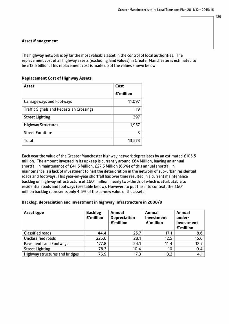
129
Greater Manchester’s third Local Transport Plan 2011/12 – 2015/16
Asset Management
The highway network is by far the most valuable asset in the control of local authorities. The replacement cost of all highway assets (excluding land values) in Greater Manchester is estimated to be £13.5 billion. This replacement cost is made up of the values shown below.
Replacement Cost of Highway Assets
Asset Cost
£’million
Carriageways and Footways 11,097
Traffic Signals and Pedestrian Crossings 119
Street Lighting 397
Highway Structures 1,957
Street Furniture 3
Total 13,573
Each year the value of the Greater Manchester highway network depreciates by an estimated £105.5 million. The amount invested in its upkeep is currently around £64 Million, leaving an annual shortfall in maintenance of £41.5 Million. £27.5 Million (66%) of this annual shortfall in maintenance is a lack of investment to halt the deterioration in the network of sub-urban residential roads and footways. This year-on-year shortfall has over time resulted in a current maintenance backlog on highway infrastructure of £601 million; nearly two-thirds of which is attributable to residential roads and footways (see table below). However, to put this into context, the £601 million backlog represents only 4.5% of the as-new value of the assets. Backlog, depreciation and investment in highway infrastructure in 2008/9
Asset type Backlog £’million
Annual Depreciation £’million
Annual Investment £’million
Annual under- investment £’million
Classified roads 44.4 25.7 17.1 8.6 Unclassified roads 225.6 28.1 12.5 15.6 Pavements and Footways 177.8 24.1 11.4 12.7 Street Lighting 76.3 10.4 10 0.4 Highway structures and bridges 76.9 17.3 13.2 4.1

130
Greater Manchester’s third Local Transport Plan 2011/12 – 2015/16
Highway authorities have a duty of care to all highway users, to maintain the highway in a condition fit for purpose. Ensuring this duty is met, reducing the risk of accidents and meeting compensation claims, absorbs an increasing amount of expenditure on reactive temporary works to make-safe faults in carriageways and footways. Innovative funding approaches have been used to bring in additional resources. For example street lighting services in some local authorities have entered into PFI arrangements that utilise private finance to fund the maintenance and replacement of street lighting assets, while the majority of bus shelters are managed and maintained by a private company in exchange for the right to display advertisements.
In the past, funding for maintenance was allocated locally on an historic cost basis. However in recent years we have been moving towards an ‘asset management’ approach. This is a regime of planned maintenance rather than reactive maintenance initiated by asset failure. The common objectives are to:
• minimise the whole life cost of assets, whilst maintaining good service levels; • support the service aims of local, regional and central government, and the community’s vision
for the future of transportation; • manage an asset’s performance, risk and expenditure in an optimal and sustainable way over its
lifecycle; and • improve the modelling of risk to optimise investment in preventative interventions.
The concept is one of a logical and holistic framework that draws together information such as condition data, asset valuation, policies and strategies, customer surveys, local plans, performance indicators, value management etc. With this information decisions can be made on where to invest to gain the best rate of return (based on financial, social and environmental factors) whilst providing a customer focused service.
Transport Asset Management within Greater Manchester will be further developed to ensure more sustainable and long lasting effective maintenance of roads and bridges, increased consistency of quality and added value from maintenance work due to the development of integrated facilities through the maintenance programme. However, all the Greater Manchester authorities are currently reviewing their programmes in the light of the economic situation and the impact it will have on the levels of service that can be delivered.
An annual financial audit is set to begin in 2012 with the introduction of Whole Government Accounts (WGA). Asset management plans are a prerequisite for these statutory requirements. WGA will state in monetary terms the change in the value of highway assets from one year to the next. It will emphasise the need to prudently manage assets; local authorities will be required to prepare financial balances detailing backlog, depreciation, and investment, which will be audited. This will underline the continued accumulation of future maintenance liabilities and the importance of reducing the backlog of investment whilst matching the annual depreciation. This information will show the financial consequence of maintenance investment decisions.

131
Greater Manchester’s third Local Transport Plan 2011/12 – 2015/16
Proposals The disparity in funding between what we are currently investing in the highway network and its rate of depreciation is storing up liabilities for the future and could potentially undermine economic development. Poorly maintained facilities will also impact on other strategy objectives eg acting as a deterrent to walking and cycling. Providing additional resources would mean either diverting investment from other transport schemes, making efficiency savings or identifying new funding sources.
We will look for opportunities to make efficiency savings through:
• moving to evidence-based budgeting rather than working on historic cost; • development of long-term budgets and scheme prioritisation systems; and • creation of a more streamlined and efficient way to deliver highway maintenance through:
o more efficient working practices through greater integration in the operation of the highway network.
o joint service delivery, service procurement and framework contracts, o smarter working, taking advantage of technological advances in mobile working and fully
integrated work management systems; o larger, more competitive joint maintenance contracts and bulk purchasing, o greater operational collaboration, eg shared back office functions; and o proportional policy and regulation funding.
We will also investigate the potential of new funding streams, such as Regional Growth Fund, Local Sustainable Transport Fund, Tax Increment Financing and Community Infrastructure Levy to provide additional resources. Highway Structures/Drainage In addition to routine maintenance, there is the need to replace a significant number of Greater Manchester’s bridges, retaining walls, gullies and culverts, many of which date from Victorian times, and to improve highway drainage in order to maintain the resilience of the network (particularly during sever weather). Significant investment will be needed to achieve this, and priorities will need to be identified with delivery of the full programme over a long-term period. Drystone walls support many rural roads on the Pennine fringe of the conurbation. Built 150 years ago, these were not designed to take highway loading. Oldham completed a £14 million, 4-year reconstruction programme in 2006, but the scale of the problem is such that Oldham, along with Rochdale, Stockport and Tameside put a business case to the Department for Transport and gained funding for a £45 million programme in 2009. In addition, there are a number of structures on the network where various restrictions have had to be imposed because of substandard strength. This obviously has an impact on routing, particularly of HGVs. The developing Transport Asset Management Plans will set out how to address this over the long term.

132
Greater Manchester’s third Local Transport Plan 2011/12 – 2015/16
Winter Maintenance and resilience of the transport system Following the severe weather during the winter of 2009/10, a review was carried out of winter gritting services across Greater Manchester with a view to developing a common policy which would then be supplemented by local action plans, taking account of variations due to local geography. Our approach includes the following: • Identification of key ‘snow routes’, agreed with neighbouring authorities and the Highways
Agency.
Case Study: Retaining Walls The hilly nature of the boroughs of Oldham, Rochdale, Stockport and Tameside means that there are a number of roads that have been built along the sides of valleys, and these are supported by retaining walls. Increasing traffic on the roads and the lack of funding for maintenance has led to the gradual deterioration of the walls over time. The four local authorities, led by Stockport, put a successful business case to Government for funding to repair 120 of the most high risk walls on over 100 roads. In 2009, the Department for Transport announced a contribution of £40.5million to add to £4.5million local funding. Work began in the second half of 2009/10 and has to be completed by March 2012. The project is run using a Prince2 programme structure with elected Member and Senior Officer representation from the four boroughs. The Senior Responsible Owner is from Oldham, the recipient of the largest share of grant funding, while Stockport continues to co-ordinate the overall Programme Management. Benefits of the partnership approach have been:
• An agreed prioritised programme across the four local authorities that was formulated according to need;
• Achieved appropriate solutions for works that affect traffic on a road network that crosses common boundaries;
• Joint commissioning via Framework Contracts for Professional Engineering Consultancy Services and Contractors has ensured procurement economies;
• Joint publicity about the scale and extent of schemes including the use of a shared website (www.roadsupport.info);
• Improved project control and co-ordination from centralised programme management and templating, such as data collection;
• Sharing of expertise and best practice by all, including external, partners, that enabled the partnership to spend to profile and thus retain funding which otherwise would have expired;
To date the repair of 40 walls at 27 sites have been completed and over £20m of the funding has been spent.

133
Greater Manchester’s third Local Transport Plan 2011/12 – 2015/16
• Investigating the possibility of shared services for neighbouring authorities and the HA, based on routes rather than administrative boundaries.
• Identifying strategic and critical local infrastructure and their priority for ploughing and gritting in extreme winter conditions.
• Working with key businesses to refresh their Business Continuity Plans to ensure resilience during extreme cold weather.
• Co-ordinated and consistent communications during severe weather events. • Ensuring that where possible, highway authorities use the same type of salt product (depending
on whether this is stored in the open or in a salt barn), to allow for mutual aid and ultimately joint procurement using more than one supplier, improving value for money and continuity of supply.
• Increasing stocks of salt and using an early warning system to reduce the risk of shortage.

134
Greater Manchester’s third Local Transport Plan 2011/12 – 2015/16
As the climate changes, we will also need to adapt to different weather. We recognise the need to consider the vulnerability of strategic roads to flooding, the potential for better warnings, strategic road clearance to avoid people becoming stranded and plans to support people who do become stranded. We will incorporate risk management strategies, in particular for surface water management, within Transport Asset Management Plans. Surface Water Management Plans are also currently being developed for Greater Manchester.
Case Study: Review of Winter Maintenance Strategy and Construction of New Salt Storage Facility, Wigan
Following on from the severe weather conditions encountered in the winter of 2009/10 there was considerable political pressure for the winter maintenance strategy to be fully reviewed and further developed to ensure that the Authority would be more resilient to future prolonged periods of severe weather. The work was broken down into the following key areas; • A review of the existing gritting routes, in consultation with other central services such
as the Ambulance, Fire and Police as well as public transport companies, to ensure they were optimised and all strategic routes were covered. Also considered was the prioritisation of salt bin sites throughout the borough, which had come under increasing focus at a local level.
• Co-ordination of other Council services during periods of severe weather • A review of the gritting vehicle fleet and how to ensure that this was maintained whilst
seeking economies in the long term, • How best to keep the public informed of what the Council was doing to mitigate the
effects of any bad weather conditions. This included the production of leaflets, electronic self help guides and a new internet based enquiry system.
• The construction of a new salt storage facility, which would have the following benefits o A 50% reduction in salt usage per unit area, as per national guidance. This is due to
the fact that the salt if kept dry is not diluted by the actions of precipitation and would therefore offer cost savings both long and short term, whilst giving the Council a higher level of resilience against long spells of extreme weather.
o Reduce theft of salt as it could be secured inside a locked structure o Offered environmental improvements over the previous situation of the salt being
stored with only a cover to protect it from the ingress of rain. This meant that the risk associated with pollution from salt water was greatly reduced.
o As a further advantage the structure could be used for storage of some of the gritting fleet vehicles during the off gritting season, rather than them being exposed to the elements whilst not in use.
The scheme funding was split approximately 60/40 between capital and revenue income streams generated by the Highways Direct Labour Organisation for the financial year 2009/10. The capital funding secured the procurement of the barn from a specialist external supplier.

135
Greater Manchester’s third Local Transport Plan 2011/12 – 2015/16
We aim to undertake a review of bridges at risk of flood damage that also contain or support other utilities and make recommendations on the replacement of vulnerable bridges or the re-routing of utilities to avoid a cascade failure. We will also undertake a detailed review of side slopes, artificial embankments and cuttings adjacent to the strategic road network and recommend site-specific actions. We will also assess the risk to bridges from thermal expansion, and monitor the structures at highest risk during periods of high temperature.
A risk management approach is being adopted for public transport. For buses, the key issue is to keep the highway network and pedestrian routes open but, for Metrolink and rail, we also need to consider whether vehicles are being maintained (and adapted, where design problems are identified) adequately to cope with different weather. For highways vegetation, we will develop a robust landscape and maintenance regime to ensure that both new planting and existing vegetation are able to tolerate different weather, such as periods of low rainfall.
Since oil is a finite resource, the issue of ‘peak oil’ (the point at which oil production reaches its peak and then declines) is of increasing concern. At some point oil supply will decline, leading to price rises that will impact both on the economy and on the cost of travel for individuals. Our proposals to promote lower carbon travel options, to improve the environmental performance of transport fleets and to manage travel demand will help to improve the resilience of the transport system to oil price rises.

136
Greater Manchester’s third Local Transport Plan 2011/12 – 2015/16
8.3 Car parking for improved access The provision of parking is essential for the functioning of the local economy. However high levels of parking, particularly if it is free of charge, tend to encourage car use and therefore work against policies to encourage greater use of sustainable transport. There is therefore a need to strike a balance between restricting parking to manage demand, and ensuring that sufficient is provided to support the local economy. Park and ride provision at rail stations and Metrolink stops can boost public transport patronage and also benefits local communities by reducing on-street parking by commuters. However, locations need to be chosen carefully, as park and ride can encourage people to drive further (eg to take advantage of cheaper rail fares in Greater Manchester), rather than walk or cycle to their local station or stop. Parking in the Regional Centre and Town Centres In order to support the economy of the Regional Centre and town centres, all the Districts Councils have parking policies designed to ensure that short stay parking, for shoppers and visitors, is available close to the centre and priced in such a way as to deter commuters, with long stay parking generally made available on the fringe. In order to encourage a shift to more sustainable modes, we will work to reduce the amount of long-term parking, used by commuters, and increase its cost over time, particularly where investment has been made in public transport. However it must be acknowledged that in some centres the majority of parking is outside the control of the local authority: many businesses and organisations provide free parking for their workforce, and a significant number of public car parks are privately owned and operated. As the regional centre for shopping, cultural assets, entertainment and services it is essential to design and manage the provision of car parking in Manchester City Centre. The Transport Strategy for Manchester City Centre (TSfMCC) recognised the need to review and improve City Centre car parking, routing and signing. Work has progressed to upgrade and expand the City Centre Car Park Guidance (VMS) System and traffic signals. A strategic level review has been undertaken into how our existing approach to parking impacts on traffic flows and congestion. A new parking strategy will examine the increased number of visitors to the City Centre on Sundays and during extended rush hour periods on weekdays, the wider availability, siting and price of car parks, existing and predicted levels of demand for parking, and the availability, accessibility and quality of alternative public transport provision. Parking in New Development In new development, high levels of free parking can encourage car travel, rather than the use of more sustainable modes, and so work against our other objectives. We will therefore continue to apply appropriate parking standards to new development as a means to manage demand and encourage the greater use of public transport, walking and cycling.
The Greater Manchester Parking Standards provide a reference point to enable Districts to apply their own interpretation to suit local needs. The standards are generally set at a maximum level of parking and for different uses, but Districts have the flexibility to vary these locally, eg to set lower levels of parking in areas that are highly accessible by public transport, such as town centres. In

137
Greater Manchester’s third Local Transport Plan 2011/12 – 2015/16
Manchester City Centre each development is considered on a case by case basis. In determining the appropriate level of car parking, factors such as the nature and scale of the development, the character and setting of its location, the current and future levels of public transport provision and opportunities for walking and cycling in the area, the safety of road users and pedestrians and the need to reduce congestion, improve air quality and reduce carbon emissions will all need to be considered.
Standards for provision for disabled people are expressed as minimum levels to be provided. However, there is flexibility for small developments where a minimum standard would be onerous or undesirable in design terms.
Local car parking standards will be reviewed as part of the development of Districts’ Local Development Frameworks.
Park and Ride The provision of park and ride improves accessibility to the heavy rail and Metrolink networks, particularly from areas not directly served by these modes. In rural areas, park and ride improves accessibility to the rail network for communities which are beyond walking or cycling distance to the nearest station. Park and ride can help to make public transport services more viable, by increasing patronage. Also, by allowing motorists to continue their journeys by public transport, it can reduce car mileage (provided that the site is well located) and thus reduce congestion and carbon emissions. At the local level, it can reduce the number of cars parked on streets around stations which can create inconvenience and safety issues for local residents and businesses. Providing park and ride can, however, encourage some people to drive to a station or stop rather than to walk or cycle so the design and location of sites needs to be carefully planned.
In Greater Manchester, most park and ride sites are used for onward travel into the Regional Centre, although smaller numbers of trips to the larger town centres are also made using park and ride. Currently, there are approximately 2,600 spaces at rail stations and 1,300 spaces at Metrolink stops on sites of varying individual capacities. There are also a number of stations beyond the county boundary with park and ride spaces used by people travelling into Greater Manchester (to the Regional Centre and other key destinations). However, the structure of rail fares clearly influences travel behaviour and demand, and can result in people driving from neighbouring areas to stations within the Greater Manchester boundary to take advantage of lower fares, rather than using their local station. This ‘railheading’ results in increased car mileage and reduced public transport revenue.
Parking is currently free at Greater Manchester rail stations and Metrolink stops. Whilst there are some arguments in favour of charging for car parking, charges would need to be set at a level that would not discourage use.
In broad terms, our policy for developing park and ride sites is to do so at stations beyond the M60 (in consultation with the Highways Agency) so that car traffic can be intercepted before it enters the areas closer to the city centre where congestion is greatest. Park and ride closer to the centre does not reduce car mileage, increases traffic on the congested part of the road network and abstracts patronage from public transport.

138
Greater Manchester’s third Local Transport Plan 2011/12 – 2015/16
For a park and ride scheme to be successful, the public transport serving it needs to:
• provide a fast and frequent service; • not be solely dependent on park and ride for its revenue (since this would be mainly during
morning and evening peaks); • have spare capacity, and • have a price that passengers see as favourable compared to the cost of driving to the final
destination and parking.
Based on the above, park and ride based on rail and Metrolink is most relevant to Greater Manchester but bus-based park and ride could also have a role where it can provide similar benefits. The main potential is on Bus Rapid Transit routes, such as the proposed Leigh-Salford-Manchester Busway, where there would be a fast, limited stop, service to the Regional Centre and where revenue would not solely depend upon park and ride.
The following new park and ride sites will be provided as part of the Metrolink extensions (see section 6.3):
• Ashton Moss • Ashton West • Derker • Hollinwood • Oldham Mumps • Sale Water Park • Shaw and Crompton
An additional number of park and ride sites have been identified, and these will be developed as funding allows. The sites are as shown below.
Metrolink Rail Bus (in association with Leigh-Salford-Manchester Busway)
Dane Road Rochdale M60/A580
Derker Flixton Leigh
East Didsbury Hindley Tyldesley
Hollinwood Horwich
Prestwich Guide Bridge
Radcliffe Irlam
Shaw and Crompton Hazel Grove
Whitefield

139
Greater Manchester’s third Local Transport Plan 2011/12 – 2015/16
In the longer term, we anticipate that the following will provide opportunities for further park and ride development: • providing additional passenger capacity on the rail network (eg through longer trains) or
operating more frequent services can create potential demand for park and ride at stations which would not have previously been suitable due to peak period overcrowding or having low frequency services;
• new proposals for rapid transit corridors (whether tram or bus-based) can create opportunities for providing additional park and ride capacity. Our approach to providing additional rapid transit is set out in section 6.3;
• improvements to the strategic highway network can provide opportunities for park and ride
where access to rail stations or Metrolink stops is improved; • new development can result in large increases in demand on key arterial corridors and generate
potential for park and ride. We will work with planning authorities and developers to capitalise on any opportunities to provide park and ride as part of a larger development, and to secure developer contributions to fund (partly or wholly) transport infrastructure wherever possible; and
• sites with future potential for park and ride, but are not deliverable in the short term. We will
pursue development of these with partners (eg through rail re-franchising). The high level of commuting flows into Greater Manchester leads to congestion on some corridors, particularly in the south-east of the conurbation. We will therefore support park and ride proposals in neighbouring areas where these would improve connectivity to Greater Manchester.
Increasing the availability of cycle parking at rail stations and Metrolink stops can widen the catchment areas of stations and stops without generating additional car traffic, and can potentially reduce the need for additional car parking spaces. Proposals for cycle parking are set out in section 7.3.

140
Greater Manchester’s third Local Transport Plan 2011/12 – 2015/16
8.4 Sustainable distribution
Greater Manchester, with its population of 2.5 million and over 1 million jobs, is a substantial production and consumption centre. Its economy was worth £42bn in 2007. This economy can only function with the support of effective freight transport and logistics, which will be vital to underpin the area’s agenda for new employment and higher productivity. Our aim is to improve efficiency and reliability of the freight network thus supporting economic growth whilst having a positive impact on a number of health and environmental factors. Our policies for freight are therefore closely linked to those for network management, rail, road safety, air quality and low carbon, described elsewhere in the document. Figure 8.2 shows key routes for freight traffic and ‘hotspots’ for delay or accidents.
Figure 8.2: Freight Hotspots and Points of Interest
Road Like many other Metropolitan areas, Greater Manchester faces the challenge of improving the reliability of journey times for goods vehicles in the face of increasing traffic on the motorway system. Whilst, with the exception of Trafford Park and Manchester Airport, the main freight-generating developments tend to be outside the inner core of the conurbation, bounded by the M60, the polycentric nature of Greater Manchester means that individual District centres also produce typical freight patterns.

141
Greater Manchester’s third Local Transport Plan 2011/12 – 2015/16
New employment developments proposed in District Local Development Frameworks will generate and attract many goods vehicle trips. Examples of such locations are Cutacre and the former Horwich Loco Works (Bolton), Carrington (Trafford), Manchester Airport and Roundthorn (Manchester), M60 Gateway (Stockport) and sites along M60 in Oldham. All these will impact on both the District highway and Highways Agency networks.
The distribution of freight in Greater Manchester is a product of its industrial history. Many of the issues we face with road freight are due to the re-use of industrial premises such as mills (or similar sites) which may have poor access (using roads not designed to carry heavy vehicles) to and from the freight network or problems of access within the site. The routes on which freight experiences congestion and delays are frequently the same as for public transport and private cars.
Freight vehicles face a number of issues:
• problems in making deliveries, due to shopping streets with no rear servicing, pedestrianisation, waiting restrictions and night time delivery curfews where premises are adjacent to residential areas;
• the use by some commercial vehicles, of SATNAV systems designed for private cars, which can lead to HGVs using unsuitable routes;
• safety issues (due to the size of many freight vehicles), including bridge strikes;
• HGVs are major contributors to carbon emissions on motorways (48%) and major roads (31%). LGVs contribute only 13% to carbon emissions on these roads; and
• HGV traffic causes much more rapid deterioration of roads than other vehicles.
Rail The amount of freight moved by rail in the Great Britain has increased steadily throughout the last decade and this is forecast to continue, as the economy moves out of recession.
A large percentage of the rail freight movements are to/from the Trafford Park freight terminal, which acts as a regional hub within the North West for containerised traffic. In addition to Trafford Park, there are a number of smaller terminals, handling other primary goods, with the majority of these being moved from the Peak District quarries in Derbyshire. The national Strategic Freight Network (SFN) proposes enhanced infrastructure in the Hope Valley, to enable more stone to leave the quarries by rail for Greater Manchester and elsewhere.
The increased importance being placed on local authorities handling domestic household waste in a more sustainable manner has also led to this material being consolidated at a number of sites in the region for onward movement by rail to landfill sites in Lincolnshire. The proposed development at Port Salford will be rail connected and is likely to increase rail freight, particularly from the intermodal market. In addition, The Port of Liverpool are currently progressing a project to create a deep sea berth to accommodate the world’s largest container ships, known as ‘Post-Panamax’. The delivery of this scheme could lead to the possibility of new onward freight flows being created to and from Liverpool, subject to gauge enhancement of certain sections of the respective routes.

142
Greater Manchester’s third Local Transport Plan 2011/12 – 2015/16
However, the ability to operate freight services is limited by:
• varying loading gauges, limiting the type of commodity that can be transported, and a lack of alternative routes with compatible loading gauges to enable trains to be routed away from congested routes; .
• a lack of passing loops, allowing freight trains to be overtaken by faster passenger services; and • the growth in demand for passenger services can restrict the availability of freight paths. The
Northern Hub project and the improvements that it would deliver on the Piccadilly – Deansgate corridor will be essential if further freight paths are required in the future.
Water The only waterway currently used by freight is the upper reaches of the Manchester Ship Canal, with a small number of wharfside handling facilities in the Partington and Trafford Park/Weaste and Irlam area. There has been some development of new facilities for specific flows in recent years but still only on a limited scale. However, the Port Salford freight terminal will benefit from berths on the Manchester Ship Canal, enabling ships of 500 teu (twenty foot equivalent unit) capacity to load and discharge at the site, making it the only inland waterway- served distribution park in the UK. Liverpool SuperPort aspirations will also aid development of the ship canal. Air Manchester Airport currently handles around 170,000 tonnes of import and export freight and mail annually. By 2015, it is expected the airport will be handling around 250,000 tonnes of cargo per year. The World Freight Terminal, comprising 55,000 square metres of purpose-built warehouse and office space is located adjacent to junction 6 of the M56 motorway and the key advantage of this location is that it can help to promote supply chain efficiency.
Proposals
We aim to support economic growth by improving efficiency and reliability of the freight network, whilst having a positive impact on a number of health and environmental factors. Our proposals are described below.
Promoting modal choice/facilitating where appropriate modal shift In the short term the main scope to improve freight movements will be on the highway network rather than the rail network. Although not all the capacity on the rail network allocated for freight is currently used, we will continue to lobby Department dor Transport and Network Rail to increase the capacity of the rail network in Greater Manchester by implementing the Northern Hub proposals (which will greatly increase freight capacity), and will seek to ensure that enhancements to passenger services are not made at the expense of key freight. In the longer term, we will explore ways in which we can support and advocate modal shift to rail and water. We will support the use of existing freight terminals, ensure good access from the local network and provide good signage. Improving journey time reliability and reducing delays on the network Our approach to network management, described in section 8.1, is based on improving the efficiency and reliability of strategic routes (both motorway and local highway network) to key destinations. These measures will benefit both freight and business journeys. However, for detailed

143
Greater Manchester’s third Local Transport Plan 2011/12 – 2015/16
access to individual destinations (ie away from the strategic routes) measures to reduce delay to, and the environmental impact of, freight vehicles will be focussed on routes with the highest flows of commercial vehicles and the worst delays. We will also need to address the use of roads not designed to withstand heavy flows of large vehicles, especially if even longer and heavier vehicles are introduced. Addressing delivery and loading problems We will target the centres with the worst problems with a mixture of physical improvements and non-capital measures to improve the management of loading. Examples of the latter are information and education, changes to delivery times, and experimental relaxation of night-time delivery curfews (on the basis that deliveries are more efficient before the peak period and can help to reduce peak congestion), however, there would need to be environmental safeguards. Improving road safety for HGVs and avoiding bridge strikes We will implement appropriate safety measures at the main goods vehicle accident locations and implement safety campaigns focused on particular users at risk, eg cyclists. We also intend to produce bridge strike diversion plans for routes around problem bridges and establish the best mechanisms for avoidance. Improving conditions at environmental hotspots We will seek to influence land use planning decisions to ensure that the freight implications and impacts of development proposals are fully considered. We will work towards a better disposition of freight generating or attracting land uses with good access from the strategic network. We will support the private sector in appraising and subsequently implementing freight consolidation centres, which can enhance supply chain performance as well as reducing the number of heavy goods vehicles entering the urban area and on unsuitable local roads. This would also provide an opportunity for cleaner vehicles to take the goods the ‘last mile’ and, depending upon location, help reduce emissions on the motorway network.
We will continue to work through the Greater Manchester Freight Quality Partnership to identify the future trends in the freight market and freight industry that will need to be reflected in transport policy and to encourage greater use of vehicles with cleaner engines (Euro6).
Assessing the need for HGV parking We will assess the need for secure lorry parking in Greater Manchester and identify any problems associated with the existing parking and fuelling facilities, taking account of the current DfT national lorry parking audit. Refining the freight network and improving signing It is vital that SATNAV systems support our aim of directing freight traffic to appropriate routes. To this end we will ensure that maps (including site specific ones) are available for freight users, and will work with SATNAV operators to organise a comprehensive freight network away from residential areas, congested or disrupted roads, whilst seeking to maintain freight movement efficiencies. In terms of strategic freight routes, the Greater Manchester Freight Map will be reviewed, concentrating on the designated centres and the routes to them.

144
Greater Manchester’s third Local Transport Plan 2011/12 – 2015/16
Assessing the role of technology to provide improved information Information provision is seen as an important part of network management. At present, local press and radio are the only means of communicating with drivers and work is underway to establish the best way of providing information eg on roadworks or during large events, to link in with existing systems. In the short term our focus will be on getting information on to the web, for use by others. In terms of information provision, our intention in the longer term is to build on the development of the Greater Manchester Traffic Control Centre to improve information dissemination, possibly by using direct communication in-cab, rather than fixed signage. Improving provision of secure truck parking We will assess the need for secure lorry paring and identify any problems with the existing parking and fuelling facilities, taking account of the DfT national lorry parking audit. Case Study: Pilsworth Experimental 18 Tonne Weight Restriction, Rochdale The Heywood Distribution Park is a major 150 acre facility near both the M62 and M66, with secure overnight parking facility for 300 vehicles. The preferred route for HGVs is via the M66 Junction 3 onto Pilsworth Road, as this route has no residential frontages. This link carries in excess of 1100 heavy goods vehicles each day. However, a number of HGVs accessed the area through the residential areas of Pilsworth Road from Heywood Town Centre and via Moss Hall Road from Heap Bridge, which had a serious detrimental impact on the quality of life for residents, particularly at night.
Previous attempts had been made to control HGV movements via 24 hour weight restrictions but there were legitimate reasons for some HGVs to use these routes during the daytime to service local companies and Heywood Town Centre. It was therefore decided to introduce an 18 Tonne Weight Restriction Experimental Order between 8pm and 6am on routes leading to the residential sections of Pilsworth Road and Moss Hall Road. This would restrict night time HGV access to the preferred route via Pilsworth Road and Junction 3 of the M66 motorway. Funding was provided jointly by LTP Capital and Heywood Township. Before and after surveys were conducted providing a clear indication of the level of compliance and success of the experiment. Overnight CCTV monitoring of the Experimental Order allowed haulage companies to be identified using automatic number plate recognition (ANPR) and informed of non compliance. The experimental scheme has been successful in reducing the number of HGVs using the route (the number observed fell from 20 to 6) even though it has only been on a self enforcement basis. A future Permanent Order will be introduced with proposed self enforcing features.

145
Greater Manchester’s third Local Transport Plan 2011/12 – 2015/16
8.5 Managing the demand for travel
A level of demand management is necessary to complement the proposed improvements to public transport, cycling and walking, and encourage people to use the improved facilities. Following the Referendum of 2008, we are not bringing forward any proposals for local congestion charging, but will continue to use a variety of other measures, appropriate to specific locations, as set out in previous Local Transport Plans. These are based on the principles of reducing the need to travel, re-allocating road space in favour of pedestrians, cyclists and buses and adopting parking policies that make long stay commuter parking less attractive. Examples of such measures include: • the use of bus lanes and signal priorities to improve bus reliability and reduce the relative
attractiveness of the car on key routes; • the use of cycle lanes and advance stop lines (to help cyclists through junctions); • local traffic calming schemes (eg in residential areas or near schools) to reduce speeds and
discourage the use of particular routes; • increased the pedestrian crossing time at traffic signal controlled junctions; • pedestrianisation in sensitive areas of town centres; • making long stay commuter parking relatively expensive, compared to short stay and locating
long stay car parks on the periphery of town centres; • the introduction of Car Clubs, such as that in Manchester City Centre, to give people the
assurance that they can access a car when they really need one, but still travel by public transport, cycle or walk for most journeys;
• planning policies to encourage mixed use development (reducing the need to travel) and to locate key services in accessible town centres;
• ensuring that all new development is ‘fibre-ready’ to allow Next Generation Broadband (NGB) connections and working with the private sector to leverage private sector investment in NGB into Greater Manchester, and
• encouraging flexible working, home working and video conferencing.
However we will continue to monitor best practice from other areas and introduce other similar measures if appropriate. We will also keep the cumulative impact of these measures under review, in terms of the impact on congestion.

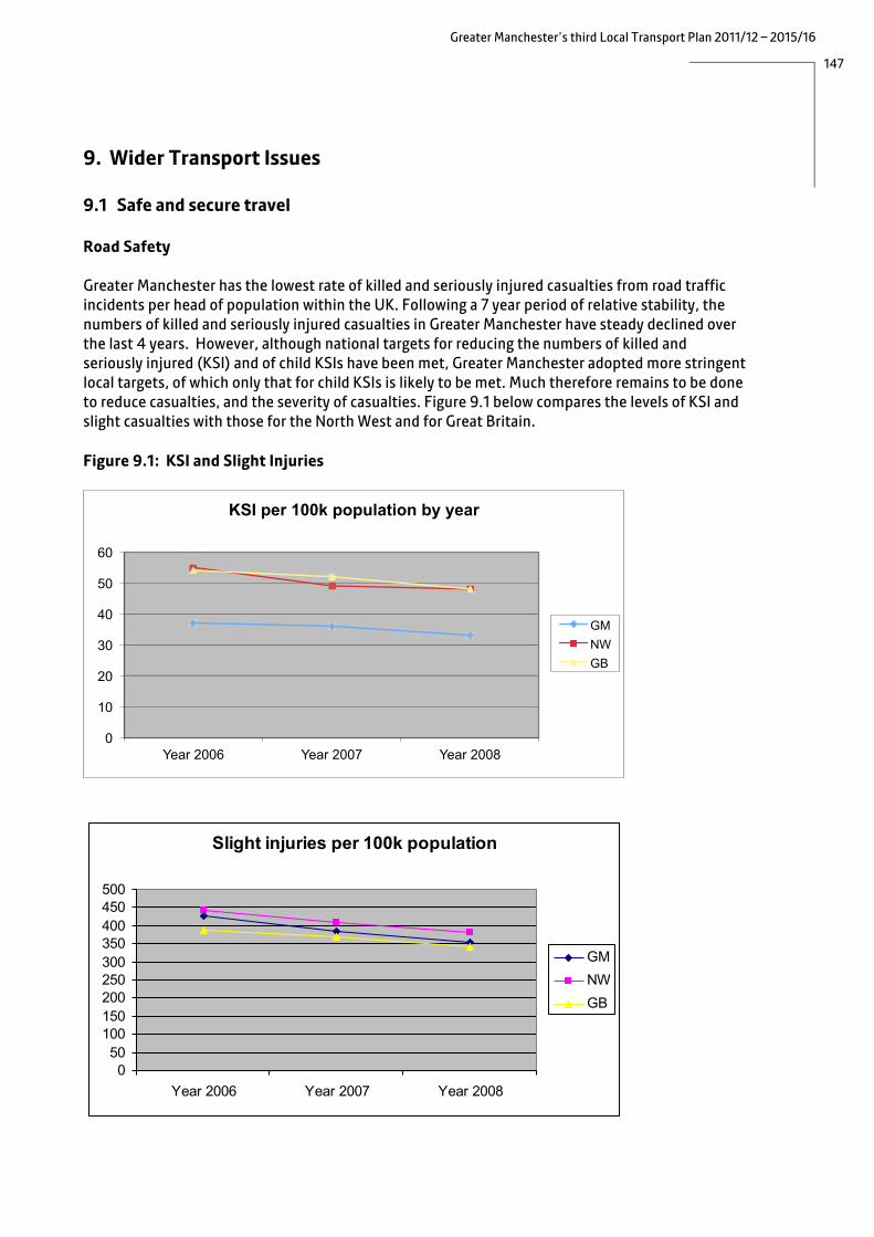
147
Greater Manchester’s third Local Transport Plan 2011/12 – 2015/16
9. Wider Transport Issues 9.1 Safe and secure travel Road Safety Greater Manchester has the lowest rate of killed and seriously injured casualties from road traffic incidents per head of population within the UK. Following a 7 year period of relative stability, the numbers of killed and seriously injured casualties in Greater Manchester have steady declined over the last 4 years. However, although national targets for reducing the numbers of killed and seriously injured (KSI) and of child KSIs have been met, Greater Manchester adopted more stringent local targets, of which only that for child KSIs is likely to be met. Much therefore remains to be done to reduce casualties, and the severity of casualties. Figure 9.1 below compares the levels of KSI and slight casualties with those for the North West and for Great Britain. Figure 9.1: KSI and Slight Injuries
0
10
20
30
40
50
60
Year 2006 Year 2007 Year 2008
KSI per 100k population by year
GM NW GB
Slight injuries per 100k population
050
100150200250300350400450500
Year 2006 Year 2007 Year 2008
GMNWGB

148
Greater Manchester’s third Local Transport Plan 2011/12 – 2015/16
Analysis of the main risk areas for road traffic casualties, based on 2009 data, shows the following. • the highest accident rates per head of population occur in the Regional Centre and town centres,
where there are high levels of activity and low levels of population (see figure 9.2); • accident rates on motorways in Greater Manchester are slightly higher than the national rate
and accidents on A roads considerably higher; • casualties are more likely to live in the deprived areas of the conurbation, where communities
live close to major roads - this is particularly true of child casualties; • pedestrian casualties accounted for 15% of the total but more than 36% of killed and seriously
injured (KSI) casualties. Despite good progress in recent years, children and elderly people are particularly vulnerable;
• 65% of all casualties (and 13% of KSI) were car occupants. Drivers involved in accidents are more likely to live in the more deprived areas of the conurbation;
• although the number of motorcycle casualties is relatively small (6%), more than a third were aged 17-25, and they account for nearly 19% of all KSIs;
• pedal cyclists account for 8% of all casualties & of these, 22% are children. The number of cycle KSIs is small in comparison to other groups, and mainly involves adults;
• the number of cycle casualties on A and B roads appears to have risen as cycling on these routes has increased;
• although LTP targets for reducing child casualties have been met and the countywide average is well below other metropolitan areas and the regional average, the Greater Manchester child KSI rate remains slightly higher than the national average; and
• the introduction of safety cameras has had an impact on all accidents, and in particular a major impact on KSI accidents. The annual average KSI accidents at new camera sites fell by 48% in the three years up to December 2009, compared to the previous three years. This compared to a 16%fall in the rest of the area.
A Greater Manchester Casualty Reduction Partnership was formed in 2007, with a remit to facilitate better management of road safety functions including merging the management of speed limit reviews, speed awareness and speed enforcement. The partners include: • regional and Greater Manchester Highway Authorities, who provide road safety education,
training and publicity and carry out safety improvements to the highway infrastructure and maintain existing safety features;
• Greater Manchester Police, who carry out road safety enforcement and awareness activities; • Greater Manchester Public Health Directors, who provide health advice and promote healthier
behaviour; and • Greater Manchester Fire and Rescue Service, who carry out safety awareness activities.
Proposals
We aim to: • minimise road traffic casualty risks and especially risks of death and serious injuries and risks to
pedestrians and cyclists;

149
Greater Manchester’s third Local Transport Plan 2011/12 – 2015/16
• protect vulnerable people and especially children, young people and motorcyclists; • support responsible road use and tackling irresponsible behaviour; and • improve health by encouraging active travel modes of walking and cycling.
The low base level of casualties in Greater Manchester makes it harder to achieve further reductions, particularly as the most effective engineering solutions have largely been delivered. To continue the recent positive trend; we propose to target casualty reduction activities at high risk behaviours and locations and in support of the most vulnerable people. This will be done through a revitalised collaborative Casualty Reduction Partnership with a remit to drive and support the casualty reduction activities of the partner organisations.
Figure 9.2: Accident (KSI) Clusters
We will introduce a shared analytical process that identifies the contributory factors that cause high levels of casualties, the behaviours partners need to influence and what locations need to be improved in order to meet the safety objectives. This may include the following casualty reduction actions: • joint publicity and communication events; • physical projects to improve the highway (eg converting signalised junctions to an all-red phase
for traffic (allowing pedestrians to cross safely), or introducing traffic calming measures and parking restrictions);
• enforcement actions (eg introducing speed cameras and mobile enforcement); and • training and education projects.

150
Greater Manchester’s third Local Transport Plan 2011/12 – 2015/16
The approach is based on providing information about high safety risks and campaigning to encourage responsible behaviour on our streets, providing a driver improvement programme and prioritising enforcement of speeding, drink or drug driving, seat belt use, parking and moving traffic offences on high risk routes at high risk times to tackle irresponsible behaviour, delivering local safety projects to minimise traffic conflicts at high risk sites and providing road safety training and education for high risk people.
A collaborative approach between delivery partners has been developed with the strategic delivery of the Greater Manchester Strategy, information, behavioural change and enforcement services and loal delivery of design, management, education, and training activities.
Safety and Security on Public Transport
It is essential to maintain an attractive safe and secure public transport system for both for users and for the staff employed in the industry. Whilst the vast majority of trips on public transport in the conurbation pass without incident, it is also important to improve the public’s perception of safe
Case Study: Safer Travel for At-Risk Families An integrated education and engineering road safety initiative is operating in five disadvantaged areas of Oldham involving working extensively with both new and established partners. The project, branded as ‘Take Care Get There’, runs from April 2009 to March 2011 and is funded by DfT and Oldham Council. Residents of disadvantaged areas of the Borough have a higher risk of injury from road traffic accidents than others. Earlier interviews with families in deprived areas in Oldham have identified a significant lack of road safety awareness amongst adults to an extent that they are unable to set a good example or give good advice to their children. Our previous ‘3 ‘til 7’ project was concerned with this issue by addressing children as pedestrians and our current project builds on this by being aimed specifically at parents. The approach is based on informal engagement, particularly with the adults in the communities concerned, to improve their road safety knowledge and skills so ensuring that the messages they pass on to their children match the mainstream road safety work in schools. With our partners, we have engaged with local communities in an informal way, often with groups that are considered hard-to-reach. The strands to the project involve engagement through social gatherings, women’s groups, mosques, the youth service, children’s centres and schools, the latter to access parents. Our work includes advice on safer walking routes. However, the absence of formal pedestrian crossings is often a barrier to this. We are therefore establishing a network of zebra crossings, the locations of which have been decided through consultation with local people. Monitoring to date has shown however (a) a high level of message retention from the training sessions; and (b) significant improvements in pedestrian behaviour from surveys undertaken

151
Greater Manchester’s third Local Transport Plan 2011/12 – 2015/16
travel on the network. Transport for Greater Manchester works with key agencies such as Greater Manchester Police, British Transport Police, public transport operators and the ten the local authority Crime Reduction Partnerships (CRDP) through the Crime Reduction on Public Transport (CROPT) initiative.
A range of measures has been introduced through CROPT and are having a positive impact on the perception of safety, eg the Travel Safe Officers scheme on Metrolink, lighting levels on bus and rail stations and in bus shelters, the use of CCTV cameras and the visible presence of uniformed staff, both on and of vehicles. We will: • continue to work with operators to introduce innovative initiatives such as Bus Watch Specials,
CCTV in bus shelters, CCTV headcams for staff, data sharing, Gateway Check operations, Ghost buses and Patrol and Response Units;
• use the media to keep the public informed of the work that is done to make the transport network a safe environment;
• work with Department for Transport to include safety and security improvements in the rail franchising process, with secure station status as a long term aspiration;
• improve the monitoring and evaluation of various initiatives; • following the Patrol and Response and Bus Watch Specials initiatives, determine the optimum
way of providing patrol and response type activities; • work with operators to identify the scale and nature of ticketing fraud to enable the Police to
take appropriate action; and • share safety and security information and best practice across bus, tram and rail networks so
that all users can benefit from a safer network.

152
Greater Manchester’s third Local Transport Plan 2011/12 – 2015/16
9.2 A more accessible transport system
Our aim is for the transport network to serve the needs of everyone who lives, works or does business in Greater Manchester. To ensure that future projects and programmes maximise the opportunity to improve access for all sections of society and that there are no unforeseen consequences for specific groups, they are subjected to Equalities Impact Assessment during the planning and development stages.
In terms of providing greater equality of opportunity to travel, we are working towards improvements in the following areas:
• access to the public transport, pedestrian and cycle networks, particularly for people in isolated areas;
• information about travel options; • affordability, for people on low incomes; • physical accessibility particularly, but not only, to assist people with disabilities; and • safety and security, to give people the confidence to travel. Access to the Network
Despite an extensive public transport network, there are areas within Greater Manchester with poor access to key locations (particularly outside the Regional Centre), eg for employment or healthcare. These are areas where bus links are not commercially viable and public sector budgets are not sufficient to provide subsidised services. Figure 9.3 shows the areas from which people can access a ‘category A’ interchange (ie a major public transport interchange, giving access to the wider network) within 30 minutes.
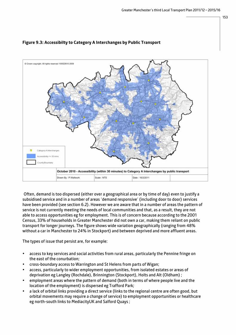
153
Greater Manchester’s third Local Transport Plan 2011/12 – 2015/16
Figure 9.3: Accessibilty to Category A Interchanges by Public Transport
Often, demand is too dispersed (either over a geographical area or by time of day) even to justify a subsidised service and in a number of areas ‘demand responsive’ (including door to door) services have been provided (see section 6.2). However we are aware that in a number of areas the pattern of service is not currently meeting the needs of local communities and that, as a result, they are not able to access opportunities eg for employment. This is of concern because according to the 2001 Census, 33% of households in Greater Manchester did not own a car, making them reliant on public transport for longer journeys. The figure shows wide variation geographically (ranging from 48% without a car in Manchester to 24% in Stockport) and between deprived and more affluent areas.
The types of issue that persist are, for example:
• access to key services and social activities from rural areas, particularly the Pennine fringe on
the east of the conurbation; • cross-boundary access to Warrington and St Helens from parts of Wigan; • access, particularly to wider employment opportunities, from isolated estates or areas of
deprivation eg Langley (Rochdale), Brinnington (Stockport), Holts and Alt (Oldham) ; • employment areas where the pattern of demand (both in terms of where people live and the
location of the employment) is dispersed eg Trafford Park; • a lack of orbital links providing a direct service (links to the regional centre are often good, but
orbital movements may require a change of service) to employment opportunities or healthcare eg north-south links to MediacityUK and Salford Quays ;

154
Greater Manchester’s third Local Transport Plan 2011/12 – 2015/16
• a lack of feeder bus services linking to the rail and Metrolink networks, making it difficult for people to access jobs further afield, eg at the Airport or outside Greater Manchester;
• new development on the edge of the built-up- area eg Middlebrook (Bolton); • a desire for improved connectivity to support development proposed in Core Strategies eg
Heywood area (Rochdale); and • access to recreational areas, particularly for deprived communities.
In the future, changes in the delivery of public services such as health and education may require changes to networks in order to support choice and access to opportunities for the individual.
There is no single solution to the types of problem outlined above, and so our approach to improving access to the network has the following elements.
• Our plans to work with bus operators to deliver, over time, a ‘Target Bus Network’ (see section
6.1) will help to ensure the bus network caters for more of the journeys that people need to make, particularly to work and education.
• We will continue to provide subsidised services where commercial services are not viable, but the extent to which this is possible depends on the level of funding available.
• We will continue to provide Local Link ‘demand responsive’ services (DRT) in areas where demand is too low to justify a conventional bus service. These provide important links to key services and local rail stations for people in rural areas and the more isolated housing estates. Our proposals to better integrate the provision of DRT across a number of different providers (eg Ring and Ride, Social Services and the NHS), described in section 6.2 will mean that the various vehicles will be used more efficiently, allowing them to provide more journeys;.
• Delivery of a number of our major schemes, funded through the Greater Manchester Transport Fund, will improve public transport access in key areas. The Oldham-Rochdale and East Manchester Metrolink extensions will link a number of key regeneration areas to major employment destinations at Kingsway Business Park, Hollinwood, Ashton Moss and Central Manchester Business Park;.
• We will take the opportunity to improve access through planned new development, where this could improve the viability of services or provide the opportunity for developer funding of improvements;.
• We will continue to work with local planning authorities and the providers of key services (eg the health sector) to ensure that access by sustainable modes is a key consideration when planning new facilities.
• We will look for opportunities to provide further Park and Ride facilities at stations, particularly in rural areas, where this would not encourage ‘railheading’ (see section 8.3).
• Our plans to improve walking and cycling links to key local destinations, including transport hubs, and as part of long distance routes have been described in chapter 7.
• Smarter Choices promotions, including area-wide travel planning initiatives, and improved travel information will make people aware of their travel options.
• Addressing bus network pinch points and local congestion hotspots will improve the reliability of services.
• We will continue to monitor access to the network, identify areas where this is a problem and develop solutions, working with relevant partners, subject to funding.
As described in chapter 5, we see improved accessibility as an essential component of smarter choices programmes to encourage people to travel by more sustainable modes. Small-scale network

155
Greater Manchester’s third Local Transport Plan 2011/12 – 2015/16
(service and infrastructure) enhancements assist in ‘locking in’ the benefits of smarter travel marketing by providing a quality of service that will maintain people’s revised travel patterns. Our proposed bid to the Local Sustainable Transport Fund will include targeted local service enhancements, including DRT/community transport, and improved access to stations and other public transport hubs, including park and ride, cycle and pedestrian access and local information programmes.
Our longer term proposals to work with the operators and the Government to target the public subsidy of the bus network so as to achieve maximum benefit for passengers have been described in section 6.1.

156
Greater ManchesterÕ s third Local Transport Plan 2011/12 Ð 2015/16
Case Study: Crewe Manchester Community Rail Partnership (CRP) and South East Manchester Community Rail Partnership These Community Rail Partnerships bring together GMPTE, Northern Rail, local authorities (Stockport, Manchester, Cheshire East or Tameside), and community and passenger groups, with the general aims of increasing passenger numbers, involving the community and improving stations and facilities. Funding comes from GMPTE, the local authorities, Northern Rail and local businesses. The Crewe Manchester CRP (CMcrp) was established in 2007 with the principal aim of regaining passengers lost when the line was closed as part of the West Coast Main Line upgrade. It also aimed to attract new passengers and to improve the railway environment for passengers. Recent achievements & activities of the CMcrp include:
• assisting continued growth along line achieving a 4.5% increase in passengers in 2010 compared with 2009. Patronage is now above pre-upgrading levels;
• promoting the line and train services including a Line Guide to attract visitors from across the north of England;
• operating a website which gets some 8000 unique hits a month; • undertaking special events to promote rail services to potential users including a
scheme to encourage use by schools and young people; and • Providing assistance with market research on behalf of Northern Rail and Passenger
Focus.
Immediate priorities include: • implementing fundraising and volunteering strategies to attract more resources in cash
and kind, as public purse funding dries up; • encouraging more volunteer led projects including station gardens; • encouraging use and knowledge of railway by non-users, especially young people; and • lobbying for resources for stations.
The South East Manchester CRP (SEMcrp) was established in January 2011 with a focus on improving access to key services for a population with low car ownership. It will also provide an effective way of engaging with the local community, improving the station environment and ultimately helping to safeguard the continued future use of the stations. Its aims are to
• engage with the communities along the routes; • promote rail services and increase patronage; and • improve Stations and their environments.
Initial work priorities include
• assisting the work of the Hattersley Partnership (Tameside) and the Brinnington neighbourhood Renewal Team in the areas surrounding their stations, including working with schools and encouraging community involvement at stations;
• helping to establish Ô Friends ofÕ station groups along the lines; • developing awareness of the CRP and contacts with volunteers; and • lobbying for investment in the stations and the areas surrounding them.

157
Greater Manchester’s third Local Transport Plan 2011/12 – 2015/16
Information
Lack of information about how to travel, or about whether services are running or on time, can deter some people from travelling by public transport, particularly those in vulnerable groups eg elderly or disabled people. We will continue to provide information in a range of formats via a range of media (and to make improvements so that information is easier to access and understand) and use smarter choices techniques such as journey planning to make people aware of their options.
The provision of information screens on Metrolink stops (see section 6.3) will provide reassurance to waiting passengers, and our rail station improvement programme (see section 6.4) will bring improved information to the prioritised stations. In the longer term, we plan to deliver real time information about buses, using mobile phones (see section 6.5).
Travel training can help to improve the confidence of learning-disabled people to travel independently, and we will continue to provide advice and support to organisations that provide this. Affordability
Affordability is an important issue for people on low incomes, and we are aware that rises in fares may have a disproportionate impact on some groups in society (eg disabled people, ethnic minorities, and young people) where people are more likely to have low incomes. Whilst we are not able to provide concessionary travel for low income groups, our proposals to simplify fares and ticketing (see section 6.5) will help some people eg those who currently have to buy two single tickets because a different operator runs the return leg of their bus journey.
Working with operators and other public bodies, we will seek identify funding opportunities to develop ‘Workwise’ schemes, where people taking up employment are provided with both journey planning advice and free or reduced cost travel for an initial period. Several small-scale projects of this type have been run successfully in the past, and we will look for opportunities to provide schemes in a more sustainable way which we believe will help reverse worklessness in some of our more deprived communities.
Physical Accessibility
Our Network Management strategy (see section 8.1) sets out how we will continue to improve local accessibility by introducing more tactile surfaces, dropped kerbs and upgraded crossing facilities, and by ensuring that new public realm is designed to meet the needs of all users, including physically and sensory disabled and elderly people.
In terms of public transport, all new buses will be accessible by 2017 as required under the Disability Discrimination Act (DDA) and, as funding allows, we will raise kerbs at bus stops so that the full benefits of this can be realised (building on the work we have already done, particularly along the Quality Bus Corridors). However the full raised kerb programme needs to be carefully planned and prioritised in view of the cost associated with these upgrades.

158
Greater Manchester’s third Local Transport Plan 2011/12 – 2015/16
All new public transport infrastructure is now designed to DDA requirements. The Metrolink system has been designed to be fully accessible to wheelchair users, and a programme of improvements to the existing stops has upgraded the lifts (see section 6.3). The new trams are compliant with Rail Vehicle Accessibility Regulations (RVAR). This means that there is more room in circulation areas such as in and around doorways and aisles.
Mobility scooters are not currently permitted on Metrolink for safety reasons, due to their size,/shape and manoeuvrability. However we are aware that there are many different types of scooter and are carrying out a review of this policy. Similar issues exist on the rail network but due to the different types of fleet operated, no single standard of carriage for mobility scooters can be adopted and the advice of individual Train Operators needs to be sought before travelling. Broadly speaking, only the fold up ‘boot scooter’ is currently permitted. By law, accessible buses must be able to carry wheelchairs up to 700mm wide and 1200mm long. However, it is the responsibility of bus companies to decide whether they will carry scooters.
The majority of rail stations are not accessible, and it will be a major undertaking to upgrade the whole network. The Disability Discrimination Act 2005 and 2008 DfT guidelines set an end date of 2020 for all passenger-based rolling stock to be accessible for disabled people. They also specify a framework for reasonable adjustments to the built environment. Although the duty to comply with the legislation rests with Network Rail and the train operating companies (other than in relation to Horwich Parkway, which is owned by Transport for Greater Manchester), we do have a legal duty as a public sector organisation to ensure that work is undertaken to improve disabled peoples’ access to the rail network. We therefore carried out a study to assess each station in terms of the capital cost of the necessary improvements, station usage, disability levels in the local area and highway distances between the station of concern and the nearest accessible station. As a result, we have identified a ‘top ten’ list of stations where we will work with the rail industry to make improvements. To achieve a more even geographical spread, stations in the inner area have been balanced with those on the periphery. The stations are:
• Blackrod • Mills Hill • Appley Bridge • Walkden • Newton for Hyde • Daisy Hill • Irlam • Broadbottom • Hindley • Swinton On the bus network, customer care by drivers is an issue frequently raised by people with disabilities. Under the Code of Conduct for bus operators (see section 6.1), Code partners will have a structured driver training programme in place, based on the Driver Certificate of Professional Competence requirements. This must include training based on safe and fuel efficient driving. The Code also states that driver training programmes should recognise the requirements of disabled passengers and adopt good practice principles. In this respect, the guidelines set out in the GMPTE booklet “Easier Access on Greater Manchester’s Buses” (which provides advice to operators and points out their responsibilities under the DDA) are recommended.

159
Greater Manchester’s third Local Transport Plan 2011/12 – 2015/16
Safety and Security
For many people, particularly those in minority or vulnerable groups eg elderly or disabled people, concerns over safety and security are a deterrent from using public transport, particularly at night. Section 9.1 describes the measures we are taking, not only to improve safety and security but to improve perceptions of safety. We will continue to maximise safety through the design of infrastructure, the provision of a staffed presence on the network, and through effective joint working with Greater Manchester Police and via local Crime and Disorder Partnerships.
In terms of road safety, children in disadvantaged areas are many times more likely to be involved in an accident than those in wealthier ones. Many communities live alongside busy radial routes, or are affected by rat-running as motorists try to avoid congestion. Our road safety policies are described above.

160
Greater Manchester’s third Local Transport Plan 2011/12 – 2015/16
9.3 A greener transport system Introduction
Our overall strategy is centred on increasing travel by sustainable modes, using a combination of:
• Improvements to public transport and to infrastructure for walking and cycling (see chapter 7); • Better integration of transport and new development, through the GMSF (see section 3.2); and • Encouraging smarter travel through improved fares, ticketing and information, management of
demand for car travel and promotional campaigns (see chapter 5 and sections 6.5 and 8.5). Through these policies, covered previously in this document, a switch away from car use will contribute to improved air quality, reduced carbon emissions and the protection of biodiversity. However we are also committed to action to tackle these issues directly, and policies, relating to air quality, carbon reduction, noise, biodiversity and scheme design are set out in the following section. Air Quality
Poor air quality has a real and significant effect on people’s lives and on the economy as a whole. Across the UK, current estimates18 are that up to 35,000-50,000 people die prematurely from exposure to air pollution. Our principal aim is substantially to reduce the negative impacts of air pollution on health and the environment in Greater Manchester. Whilst in the short and medium term the priority is to meet statutory limits for major pollutants in all areas, the longer term aims are to promote the image of Greater Manchester as a progressive city region with a high quality environment and to reduce the contribution of air pollution to poor health in deprived areas (which can compound and propagate the problems of deprivation). The encouragement of active travel modes will assist in reducing emissions whilst simultaneously improving air quality and the health and productivity of our residents.
Currently many areas within the conurbation, as in many other urban areas across the UK, exceed EU thresholds for nitrogen dioxide (NO2) concentrations and the requirement to meet these limits in all areas by 2010 has not been met. This is shown in Figure 9.3 below. The UK Government is therefore in the process of applying to the EU for an extension of the deadline from 2010 to 2015 (as permitted in EC Directive 2008/50/EC). Current forecasts commissioned by Department for Environment, Food and Rural Affairs indicate that many parts of Greater Manchester and other urban areas will continue to exceed the limit values in 2015.
18 The lower estimate provided by Environment Research Group, King’s College London and the higher estimate by the European Environment Agency, cited in a report by the Environmental Audit Committee (2010) Air Quality 5th Report http://www.publications.parliament.uk/pa/cm200910/cmselect/cmenvaud/229/22902.htm

161
Greater Manchester’s third Local Transport Plan 2011/12 – 2015/16
Figure 9.4: Areas Exceeding NO2 Thresholds
The Greater Manchester Air Quality Strategy and Action Plan (2006) set out a wide reaching package of measures to address air pollution from road transport (accounting for more than 60% of all emissions of NO2 and PM10 (particulate matter) in Greater Manchester in 2006). A particular focus of the strategy was to ensure that all areas of Greater Manchester would meet EU limits for NO2 in 2010. However, it is apparent that the action plan has made very little difference to NO2 concentrations at most road side locations, since the impact of the individual measures was dispersed across the conurbation. We therefore need to focus activity on the most beneficial options and to concentrate initiatives geographically.
Different modes contribute differently to emissions of NOx, carbon dioxide and particulates. Whilst cars constitute half of road transport emissions of carbon dioxide, ‘other goods vehicles’ (OGVs), including rigid and articulated HGVs, are the major contributors to NOx. The potential impact of measures targeted at OGVs is high, given that they represent only 6.5% of the total vehicle distance travelled on major roads (including motorways) in Greater Manchester19. Although buses are responsible for a far smaller proportion of NOx emissions, these emissions are concentrated on congested urban corridors where the exposure of the population is high, which adds to their significance. The need to reduce NO2 concentrations in the short term will therefore require a focus on HGV and bus emissions.
19 Based on figures from GMTU Report 1476 Transport Statistics 2008
162
Greater Manchester’s third Local Transport Plan 2011/12 – 2015/16
In the longer term the approach will be to influence and integrate air quality strategy with parallel climate change strategy. The contribution of each mode to particulate emissions is similar to that for carbon, which means that measures to reduce carbon emissions will also reduce emissions of particulates.
Our approach to improving air quality will be based on: • reducing acute pollution incidents from traffic; • improving vehicle efficiency including vehicle and fuel technology and efficient driving
techniques; • reducing trips by motor vehicles; and • improving network efficiency.
In terms of reducing trips by motor vehicles, our strategies to increase the levels of walking and cycling and public transport use (given that a single vehicle can carry many passengers) have been described elsewhere (see chapters 6 and 7). The impact on air quality of a mode shift to public transport will be greatest on the main corridors to the Regional Centre, where passengers have access to newer buses, introduced through Quality Bus Corridor schemes, and Metrolink, which is pollution free at the point of usage. Elsewhere, the picture is complicated by the fact that many buses perform poorly in environmental terms, but our proposals to raise the quality of bus vehicles, in partnership with operators, will be beneficial in terms of air quality. Different types of diesel train use different quantities of fuel, and the better quality diesel trains we are seeking in order to improve passenger comfort will use more fuel per passenger mile. Electrification is always better in air quality terms, and we will continue to support, and lobby for, further electrification of the rail network. Our approach to managing the highway network, described in section 8.1 aims to reduce the variability of journey times and maximise efficiency of the network. Reducing congestion will cut emissions by reducing the need for excessive acceleration and deceleration or for travelling at slow speeds, at which engine performance is sub-optimal. However, this may not be the case in all instances and so impacts on air quality need to be understood in the context of local conditions.
In the short term, options under consideration to reduce acute pollution incidents from traffic and to improve vehicle efficiency are:
• an annual programme of vehicle emissions testing on major transport corridors; • extending the enforcement of idling vehicles, which is already carried out in the Regional
Centre, to town and district centres; • targeted renewal of buses on routes into the Regional Centre and in adjacent areas where
permitted levels of pollutants are exceeded; • support/lobby central government for a national HGV scrappage scheme and work with the
government on complementary regulation measures; and • co-ordinate the up uptake of Safe and Fuel Efficient Driving (SAFED) training for smaller freight
and bus operators and promote continued updates to driving skills through a best practice scheme.

163
Greater Manchester’s third Local Transport Plan 2011/12 – 2015/16
Case Study: Green Bus Fund Dft invited bids for funding to cover the difference in purchase price between a ‘green’ bus and the equivalent standard vehicle. Two rounds of bidding were held, in 2009 and 2010, and previous winners were invited to increase their initial allocations in January 2011. GMPTE submitted a number of bids to support the purchase of low carbon hybrid diesel-electric vehicles for use on various services. Overall, the total value of funding awarded is £5.23m to support the purchase of 88 vehicles, which must be in operation by April 2012, requiring Transport for Greater Manchester to secure the remaining capital cost, in the order of £12.11m. The vehicle supply contract was procured through an external framework agreement, together with an initial 5 year repair and maintenance contract. The number of vehicles secured in each round is as follows: Vehicle Type Round 1 Round 2 2011 ‘top-up’ Metroshuttle 20 Yellow School Bus 16 15 8 General subsidised network 25 4
(MediacityUK shuttle)
Commercial services (bid by Bus Operators)
48 20
Airport services (bid by Manchester Airport)
- 4
Total 114 23 28 The investment by Transport for Greater Manchester will be repaid by the projected savings to be made by operating the vehicles on tendered services when compared to the more usual operating model of operators supplying vehicles themselves. These savings come from a wider market of interested operators (and hence increased competition for tenders) and lower tender prices. The impetus behind the allocation of a fleet of hybrid vehicles on the Metroshuttle service was the expiry of the previous contract. For the Yellow School Buses, financial contributions were also made by Stockport and Wigan Councils. The buses will be used to replace operator-owned vehicles on existing conventional school services, including new academies. Sufficient subsidised services across the whole of Greater Manchester were identified as part of the bid for vehicles for use on general subsidised services. Packages of daytime, evening and Sunday services were identified for over 50 vehicles to allow greater flexibility in deploying vehicles to contracts which offer best value for money throughout the project. Once the vehicles have been fully bedded in, an average of 20% reduction in greenhouse gas emissions from the vehicles should be achieved.

164
Greater Manchester’s third Local Transport Plan 2011/12 – 2015/16
Low Emission Zones (LEZ) targeted at HGVs, LGVs and buses have been promoted as a key policy instrument through the national air quality strategy and subsequent guidance20. However we are concerned about the potential impact of a LEZ on the economic recovery in Greater Manchester, and the likely disproportionate effect on smaller freight and bus operators. We have already indicated to DEFRA that this could not be a viable solution without a significant pledge of financial support to businesses in order to accelerate the replacement of their fleets.
In the longer term our strategy will focus on measures to encourage the uptake of electric vehicles, which are described below although it is also recognised that the market penetration of electric and hybrid vehicles is likely to be relatively modest prior to 2020 in even the most favourable of policy environments
The localism agenda is an important aspect of Government policy that will have a bearing on how we propose to deliver future air quality improvements and in particular on our ability to bid successfully for funding of initiatives. Whilst we may be heavily dependent on national measures to deliver targets for 2015 and 2020, it is clear that we will also need to focus on engagement with partners (in particular with the health sector), businesses and local communities in the delivery of air quality improvements. Total Place initiatives and ‘place-based budgeting’ may present important opportunities to engage with the communities that are affected by road transport pollution and this fits well with the likely need to tackle localised air pollution hotspots up to and beyond 2015.
Noise
The noise from traffic is a problem for communities who live along major roads. In accordance with the EU Environmental Noise Regulations (2006), the UK Government has formally adopted Noise Action Plans (NAP) for a number of the largest urban areas, including Greater Manchester. The Noise Action Plan for Greater Manchester has identified the areas within the conurbation most susceptible to high levels of noise, and the broad types of interventions needed. We are awaiting further information from DEFRA about the development of detailed action plans for target areas. This will include ensuring that options for noise reducing infrastructure (for example, negative textured surfacing) are fully appraised as part of Transport Asset Management Plans (TAMPs).
20 http://www.defra.gov.uk/environment/quality/air/airquality/local/guidance/documents/practice-guidance2.pdf

165
Greater Manchester’s third Local Transport Plan 2011/12 – 2015/16
Carbon Reduction
The Passenger Transport Executive Group, PTEG, commissioned a report in 2010 entitled ‘Carbon Pathways for Transport in City Regions’. This makes recommendations for how the carbon emissions from transport can best be reduced in urban areas. Whilst we are still considering how the recommendations can best be taken forward, it is clear that a ‘package’ approach will need to be adopted, for example combining smarter choices campaigns with targeted investment in walking, cycling and public transport infrastructure. Four key themes emerged:
• low carbon vehicles;
• more efficient use of vehicles;
• shift towards more carbon efficient modes; and
• reduction of the need to travel, and destination changes.
This document has already described our proposals for highway management, walking, cycling, public transport and smarter choices, all of which will contribute either to the more efficient use of vehicles or a shift towards more carbon efficient modes. In addition, the improved integration between transport and land use planning (see section 3.2) will contribute to reducing the need to travel and destination changes. Our proposals for low carbon vehicles are set out below.
The transition to low carbon technology is of great strategic importance to Greater Manchester and its aspiration to be a Centre of Excellence as a Low Carbon Economic Area. The overall national strategy focuses on the support to research and development, on regulatory and economic incentive mechanisms to provide the industry with much needed market certainty and, crucially, the development of infrastructure necessary to enable the mass expansion of alternative vehicle technology.
As described above, 138 new hybrid electric buses will be brought into service in Greater Manchester over the next few years, as a result of successful bids to the Government’s ‘Green Bus Fund’. These will be beneficial both in terms of air quality and carbon reduction and we will work with operators to introduce more of these over time, as funding allows. We will also support the use of alternative fuel sources for buses, where these are genuinely better for the environment and are cost-effective.
In December 2010 a consortium of Greater Manchester authorities and businesses was awarded £3.6 million from the Government’s ‘Plugged in Places’ programme to provide match funding for over 300 charging points for electric vehicles. The scheme is a partnership between the public and private sectors and is intended to incentivise the market for electric vehicles (EV), supporting the Government scheme to subsidise the purchase of new EVs. The scheme will develop innovative vehicle sales and charging hubs called ‘Pods’, which will showcase a range of EVs, communicate the benefits of EV ownership and provide consumer information. Four Pods will be built, in Manchester City Centre, Oldham, Stockport and another location still to be determined. In addition to charging facilities, each Pod will have a range of facilities tailored to its specific location, for example: retail facilities; vehicle sales, hire or leasing; and after sales care. Details of the scheme including, for example the precise mix of facilities, the source of electricity to be used and the potential to work with neighbouring authorities, are still to be developed.

166
Greater Manchester’s third Local Transport Plan 2011/12 – 2015/16
There is potential to combine this project with the roll out of the Greater Manchester Smartcard (see section 6.5). This will provide a single e-payments system, centralising charging and payments for all transport services offered to the public across the area. Since our Smartcard developments are already aligned with ITSO Smart Ticketing standards of interoperability and EMV contactless cards, the scheme will be interoperable not only with other modes of transport locally, but with other ITSO compliant schemes nationally.
The scheme will target public and private sector vehicle fleets in the first instance and will include promotions for taxi fleets to switch to EVs, including charging hubs where they can charge, park and get after sales support, and specific privileged access to areas that have previously been controlled.
We have also identified a need to save energy (and hence reduce emissions), by improving the efficiency of the Metrolink traction current and the lighting at stations and stops, buying energy on ‘green’ tariffs and looking for opportunities to generate renewable energy. The Rochdale Interchange scheme is an example of how this can be achieved: it includes a hydro-electric scheme on the river Roch.
There are a number of ways in which the maintenance of the highway network can reduce our carbon footprint. There is the potential to reduce energy costs in street lighting by utilising the latest techniques for switching off and dimming where appropriate, and to reduce energy usage by utilising the latest LED lighting technology where whole life costing shows an economic benefit. This will, however, require large scale retrofitting or replacement of existing stock and would therefore take time to implement. In the short term we will optimise performance through the type of lamp, maintenance standards and setting of solar cells.
Where appropriate, we will use recycled, re-used and cold materials for highway maintenance to minimise waste. Greater collaboration between highway authorities on procurement will also reduce carbon usage: through bulk purchase and through optimal use of salt, storage, vehicles, fuel and staff resources. We will also investigate the potential for different road surfaces to improve fuel consumption and therefore reduce carbon emissions. Biodiversity
We are very conscious of the need to reduce and mitigate the impact, particularly of road traffic, on land and biodiversity. In terms of environmental protection and management, we are confident that our standard procedures, including Environmental Impact Assessment for all major new transport schemes, will minimise and mitigate any adverse impacts. For example, Tree and Habitat Replacement policies were adopted for the new Metrolink extensions. As a result, at least 5 young trees will be planted for every tree removed as a result of Metrolink extensions, and at least 2 saplings will be planted for every sapling removed. The species will be chosen for their wildlife value and will have been grown in the North West. Any woodland, wetland or other habitat of high nature conservation value removed as a result of Metrolink extensions will be replaced, while habitat of lower value (eg mown grassland) will be replaced by higher value habitat, planned with local communities. Construction work is subject to audit and consequently timed to avoid the bird nesting season and where protected species are found, they are moved according to nationally agreed best practice.

167
Greater Manchester’s third Local Transport Plan 2011/12 – 2015/16
In terms of protected sites, the Strategic Environmental Assessment identified the need to avoid disturbance to the Rochdale Canal Special Area of Conservation during the construction of Metrolink to Rochdale. The line crosses the canal twice, and we will need to ensure that there is no pollution of the water.
In addition to specific schemes, the general growth in traffic, particularly heavy goods vehicles, can also have a significant impact, through air pollution, noise and climate change. This is of particular concern in relation to the Peak District National Park, where heavy trans-Pennine traffic passes through a vulnerable ecosystem. Our strategy to encourage a mode shift to sustainable transport, for both passenger and freight traffic will help to reduce these impacts. We are committed to developing a solution to traffic problems in the Longdendale area that will help to minimise the impact on the National Park, by encouraging greater use of sustainable transport. Greater Manchester and its surrounding areas contain a number of statutory nature conservation sites of European level Importance. These include Special Areas of Conservation, Special Protection Areas and Ramsar Sites, known collectively as European Sites. These sites are protected under the European Habitats Directive. In some circumstances, proposals identified in the LTP are at an early stage of development and it is not possible to ascertain as yet whether they may result in impacts upon European Sites, for example the Longdendale ITS. The objectives of LTP3 seek to avoid development which is ultimately determined to have an adverse effect on the integrity of a European Site except in exceptional circumstances as defined in the UK Habitats Regulations. In circumstances such as these, schemes will be subject to a Habitats Regulations Assessment at the project level which is in accordance with national and European law. We are also aware of the potential impact of highway maintenance regimes on biodiversity, and our approach to this problem is set out in section 8.5 Walking and cycling routes offer opportunities to benefit green infrastructure and connectivity and we will seek to complement the proposals in the Greater Manchester Green Infrastructure Strategy to improve the connectivity of green spaces and designated wildlife sites. Green infrastructure also provides a range of wider benefits, including carbon storage and sustainable drainage, and we will take opportunities to incorporate this into scheme design where feasible. Wider Environmental Issues
We aspire to the highest possible levels of sustainability within new infrastructure projects. Transport for Greater Manchester adopts the following key design principles, during the development stages of all projects:
• Projects are required, as a minimum, to comply with all local planning authority rules requiring the use of renewable energy (through onsite energy generation) in order to reduce annual carbon dioxide emissions;

168
Greater Manchester’s third Local Transport Plan 2011/12 – 2015/16
• Projects should aim to achieve BREEAM/CEEQUAL ‘Excellent’ ratings for new build schemes and ‘Very Good’ ratings for refurbishments. Where projects are unable to achieve this, appointed design consultants are required to submit a separate report explaining why this is not possible;
• Where possible, ‘A+’ or ‘A’ rated materials should be specified from the British Research Establishment’s (BRE) Green Guide to Specification, in order to ensure that the full environmental impacts of the materials specified are considered;
• Materials that are available from local suppliers (UK) should be specified to minimise impacts from transport and to support the local economy;
• Recycled materials should be specified where available and cost effective. As a guide all projects should seek to achieve at least 10% of the materials value of a construction project derived from recycled content. Once again, appointed design consultants are required to provide robust justification where this is not achievable;
• All Energy Management Systems should be capable of remote monitoring and sub metering of all utilities supplied for use by sub-tenants must be provided;
• All designers should consider the opportunity for Sustainable Urban Drainage Solutions (SUDS); and
• Designers are required to take cognisance of prevailing local and national carbon reduction targets in the development of all schemes.
Transport for Greater Manchester also works with project partners to ensure that the highest levels of sustainability are achieved in the development and delivery of all of its schemes which are delivered through third parties.


170
Greater Manchester’s third Local Transport Plan 2011/12 – 2015/16
10 . Implementation 10.1 Governance
Following 20 years of voluntary co-operation through the Association of Greater Manchester Authorities (AGMA), the Greater Manchester authorities have now received a Ministerial decision to establish the Greater Manchester Combined Authority (GMCA), which will become the accountable focus across Greater Manchester for integrating economic development, regeneration, planning, housing and transport policies. The authorities also see a Local Enterprise Partnership (LEP) as a key component of these governance arrangements to build on the unique public and private partnership that is already in place. LEPs have been promoted by the Government as a key element of it’ localism strategy. The Greater Manchester LEP represents a further opportunity for Greater Manchester’s businesses, local authorities and our key partners to build upon a long period of voluntary collaboration to achieve a step change in our ability to secure private sector led economic growth, whilst ensuring our residents are able to benefit from, and actively contribute to, this growth. Together, the Greater Manchester Combined Authority and the LEP will enable the private sector to play an even more active leadership role in securing economic growth and allow for the effective alignment of decision making and delivery in key areas such as economic development, regeneration, planning, transport, housing, inward investment, business support, marketing and tourism, and employment and skills.
The reformed public sector governance system also includes a new approach to the way in which transport systems are managed in Greater Manchester. The current transport governance arrangements have been re-focused around the new “Transport for Greater Manchester” which will provide an enhanced focus on coordinating transport and economic regeneration objectives to effectively prioritise and deliver initiatives that best support the GMS objectives. Alongside this, we are developing with the Government new models of working (or “protocols”) for local rail, highways and bus systems.
Transport for Greater Manchester takes on the former responsibilities of GMPTE, and additional responsibilities in respect of traffic signals, transport studies and forecasting, network management and road safety (all of which were previously co-ordinated across the conurbation by various AGMA-funded bodies). Transport for Greater Manchester will ultimately report to the Greater Manchester Combined Authority. However, most direction will be given by a new Transport Committee, comprising members of all ten authorities, which will have delegated powers from the Greater Manchester Combined Authority. The division of responsibility between Transport for Greater Manchester and Local Highway Authorities in these four areas is summarised below.

171
Greater Manchester’s third Local Transport Plan 2011/12 – 2015/16
Area Transport for Greater Manchester
Local Authority
Traffic Signals • Manage signals to take account of both the strategic and local road networks
• Design, construction & maintenance
• Identify locations for new signals • Inform Transport for Greater Manchester
of priorities • Complementary highway works at signal
locations
Studies/forecasting • Strategic transport analysis and advice service
• Maintain databases • Traffic counts, transport
surveys, modelling and advice to local highway authorities
• Identify required studies and forecasting work needed
• Use outputs from Transport for Greater Manchester work
Network Management
• Provide safety and travel information
• Behavioural change campaigns
• Co-ordination of enforcement across agencies
• Proactive management of street works, events & incidents
• Resilience plans for the strategic network
• Appoint a Traffic Manager for each local authority
• Junction and traffic lane improvements • Traffic management • Co-ordination of streetworks • Parking and bus lane enforcement
Road safety • Analysis of data • Advice on strategy
• Highway measures to improve safety • Speed management strategy • Enforcement actions • Training & education • Measures for reducing casualties
The new governance arrangements are aimed not only at improving joint working within Greater Manchester. New models of working (or protocols), described in Section 2.1, have been developed for local rail, highways and bus systems. These are aimed at securing improved outcomes for Greater Manchester from central agencies (Department for Transport, Network Rail and the Highways Agency) to facilitate the delivery of the Greater Manchester Strategy. The more robust internal governance arrangements and accountability, put in place through the Greater Manchester Combined Authority, have enabled us to secure greater powers for the conurbation through these protocols.

172
Greater Manchester’s third Local Transport Plan 2011/12 – 2015/16
Localism In securing the transfer of powers from central government to Greater Manchester, and through greater local accountability, the new governance arrangements are entirely consistent with the Government’s Localism agenda. While investment in major schemes will be prioritised to deliver the Greater Manchester Strategy, local transport schemes and maintenance will be developed and delivered at the local level, as set out in Local Area Implementation Plans. In the first few years of this strategy, funding for small schemes through the ‘Integrated Transport Block’ will be much lower than in recent years (although funding for highway maintenance will be maintained). As a priority, we will therefore be seeking additional funding sources to deliver local improvements in sustainable transport. These are discussed in section 10.2. In particular, our bid to the Local Sustainable Transport Fund is focussed on active travel, delivery of smart travel information and promotion, and local network efficiency and accessibility enhancements.

173
Greater Manchester’s third Local Transport Plan 2011/12 – 2015/16
10.2 Funding Greater Manchester Transport Fund
During 2009, we undertook a programme of work to prioritise major transport investment proposals in Greater Manchester. The aim of this process was to rank schemes which should be delivered first when funds became available. Schemes were prioritised on the basis of their impact on employment growth and GVA, subject to improving social and environmental outcomes. Deliverability and state of readiness were also an important consideration. A key output of the work was to inform Greater Manchester’s advice to 4NW (the former North West Regional Leaders Board) on the proposed spend for the Regional Funding Allocation, which had at that time identified £448 million for major schemes in the conurbation in the period 2009-2019. It also identified a funding package to bridge the gap between the total cost of the schemes and the available RFA. The Greater Manchester Transport Fund (GMTF) is a Major Transport Scheme Prioritisation and Funding Strategy and was agreed by AGMA on 24 July 2009. The investment package is funded from various sources including the Regional Funding Allocation from the Department for Transport, the annual levy for transport services, a topslice from the Greater Manchester Integrated Transport Block (LTP), and local/third party contributions. Transport for Greater Manchester will repay the borrowings from a combination of: Metrolink net revenues (revenues net of operating, maintenance and other related costs); annual ring-fenced levy contributions; and local revenue contributions.

174
Greater Manchester’s third Local Transport Plan 2011/12 – 2015/16
The priority schemes within the GMTF are as follows.
Schemes Currently Being Delivered Metrolink: Droylsden to Ashton Metrolink: Chorlton to East Didsbury Metrolink: Oldham Town Centre Metrolink: Rochdale Town Centre Metrolink: Airport Line Altrincham Interchange Bolton Interchange Leigh-Salford-Manchester Busway Ashton Northern Bypass Park and Ride Schemes Awaiting Department for Transport Funding Decisions21 Cross City Bus Schemes Being Developed Metrolink: Second City Crossing SEMMMS Road Scheme Longdendale Integrated Transport Strategy Wigan Inner Relief Road Rail Station Improvements Other Priority Schemes Metrolink: Trafford Park Stockport Interchange Stockport Town Centre Accessibility Improvements Transport Improvements in the North Bury and West Rochdale corridors
Central funding for transport schemes has been reduced following the Comprehensive Spending Review in 2010. We will be seeking additional funding sources to add to GMTF as necessary.
21 Rochdale Interchange (not part of GMTF) is also awaiting a Department for Transport funding decision.

175
Greater Manchester’s third Local Transport Plan 2011/12 – 2015/16
Minor Works and Maintenance
As described above, we are committed to delivering a substantial investment in major schemes through the GMTF, and this includes making a contribution from local funding from the Integrated Transport Block (ITB or ‘minor works’ funding). As a result of the economic situation, the Government has reduced the level of ITB funding nationally. This means that we have had to make hard choices in the short term and focus all of the ITB on supporting the committed major schemes, some of which are already under construction.
In the first three years, therefore, the District Councils will be seeking to identify their own internal funding to deliver small local schemes (their programmes are summarised in section 10.3 and described in detail in the Local Area Implementation Plans). We will, however, be looking to protect funding for highway maintenance as a local priority. In year 4, when ITB is scheduled to increase again, we will once more be able to use it to deliver a programme of minor works. Our plans to secure funding from alternative sources are described below.
In addition to highway maintenance, all the authorities will continue to provide a range of services not funded from ITB, as their budgets permit. For example, Transport for Greater Manchester will provide a range of passenger information services, tendered bus and school services, Ring and Ride and concessionary fares. District Councils will continue to provide services such as street lighting, parking services and school crossing patrols.
The level of funding provided by Government for the Integrated Transport Block and for Maintenance during the Comprehensive Spending Review period (2011/12 to 2014/15) is shown in the following table. Final allocations Indicative allocations
Block Allocations 2011/12 £’000
2012/13 £’000
2013/14 £’000
2014/15 £’000
Integrated Transport 21,462 22,893 22,893 32,193 Highways Capital Maintenance 27,434 26,153 25,323 23,542
Other Funding Sources The current economic situation has led to a significant reduction in the resources available for Greater Manchester authorities. In order to continue to deliver the Greater Manchester Strategy, an approach is being developed to align spending from a number of key funding streams and focus it on projects that will increase productivity and generate an economic return, so making it available for re-investment in other projects. The North West Evergreen Fund will be the main vehicle for this, supported by the national Regional Growth Fund, the European Regional Development Fund (ERDF) and Social Fund (ESF). A Single Investment Framework is being developed to assess projects, using a balanced scorecard approach. This will provide a standardised qualitative and quantitative assessment of strategic fit

176
Greater Manchester’s third Local Transport Plan 2011/12 – 2015/16
with the GMS, return on investment, deliverability and alignment to other investment in Greater Manchester and optimise design in relation to the funding streams available. It will extend the approach already used in developing the GMTF (described above) to ensure a common framework across a number of traditionally separate areas of activity, such as housing and regeneration as well as transport. In February 2011, the Government published a White Paper: ‘Creating Growth, Cutting Carbon’, which aims to encourage greater use of public transport and more walking and cycling. It sets out a vision for local solutions which together will have a national impact. A key measure in the White Paper is a £560 million Local Sustainable Transport Fund to address the urgent challenges of building economic growth and tackling climate change, as well as delivering cleaner environments, improving safety and increasing levels of physical activity. We recognise this as a significant opportunity to deliver the small scale local schemes that will enable communities to switch to sustainable travel for many of their journeys and bring about an improvement in the health and wellbeing of the population. We will be submitting a bid of up to £50 million to DfT and if successful it would enable us to stretch our targets in a number of areas and ensure that local communities gain the benefit from our investment in the network. 10.3 Implementation Plans Local Area Implementation Plans have been prepared for each of the ten District areas in Greater Manchester, and are available on the LTP3 website www.tfgm.com/LTP3. The key local challenges and spending proposals in the period 2011/12 to 2014/15 are also summarised in the ‘Implementation Spend Profiles’ document, located on the website. .


178
Greater Manchester’s third Local Transport Plan 2011/12 – 2015/16
11. Monitoring 11.1 Performance monitoring in LTP2 Performance against the suite of indicators adopted for LTP2 is shown in the following table. This shows progress between 2005/06 and 2009/10 (the latest date for which figures are available). The extent to which our LTP2 strategy succeeded in delivering the targeted improvements was an important consideration in developing both the strategy for LTP3 and determining the most appropriate targets and indicators. Headline indicator
Achievement in relation to expectations
Current Trend
Commentary
LTP2 area wide traffic
Met Improving Traffic levels on local roads rose very slightly in the early part of the LTP2 period, but have decreased recently due to the recession, resulting in no overall growth. On local roads, only light goods vehicles increased significantly. Traffic levels on the motorway network did grow.
Overall, this suggests that our approach to limit traffic growth, based on improving non-car modes, worked but also that traffic levels are quite sensitive to external influences like the economy. It is also worth noting that more ambitious targets to reduce traffic levels may be achievable with more rigorous approaches to demand management.
LTP6a peak traffic flow to Regional Centre
Exceeded Improving
LTP6b peak traffic flow to Other Key Centres
Exceeded Improving
Bus patronage
Met
Worsening
Bus patronage grew steadily in the LTP2 period, until 2009/10 when the effects of the recession were felt, although patronage was still higher than in 2005/06. Bus patronage on certain corridors, such as QBC corridors, increased markedly as a result of the improvements.
Rail patronage
Exceeded
Stable
Rail patronage also grew steadily, but has reached a plateau more recently as many peak time trains are approaching (or exceeding) capacity.

179
Greater Manchester’s third Local Transport Plan 2011/12 – 2015/16
Headline indicator
Achievement in relation to expectations
Current Trend
Commentary
Metrolink patronage
Met Stable Metrolink patronage was stable until 2009/10 when the effect of extensive Metrolink works and the recession combined to depress patronage; this is expected to recover and increase when the system is expanded.
LTP3 cycling
Exceeded
Improving
It was particularly pleasing to see the long term declining trend in cycle use reversed in the LTP2 period, with the target well exceeded and a number of supporting indicators confirming the increase. This is as a result of a more coordinated and intense effort to improve conditions and encourage cyclists
LTP11 walking
Met
Worsening
The picture for walking was patchy; the headline indicator suggests a significant decline after an increase late in the LTP1 period, and a number of other indicators demonstrate local variations in performance. Walking has not had the focussed attention that cycling has benefitted from, and being more diffuse is a lot more difficult to address.
LTP4 (NI 198) % car mode to school
Met overall
Improving
Mode split to schools highlighted the difference between primary schools, where non-car use increased, and secondary schools, where it increased. Whilst on track overall, this highlighted the difficulties of engaging and working with the secondary sector.
LTP12a non-car modal share to Regional Centre
Exceeded
Stable
Mode split indicators to the regional, other key centres and the airport also illustrated some success in increasing the share of trips by non-car modes, both in peak and inter-peak periods, whilst at the same time increasing the number of trips made. Improvements to non-car modes, traffic management and attempts to regenerate town centres have assisted this trend. However, the threat of out-of-town retail and employment locations remains significant.
LTP12b non-car modal share to other Key Centres
Exceeded Stable

180
Greater Manchester’s third Local Transport Plan 2011/12 – 2015/16
Headline indicator
Achievement in relation to expectations
Current Trend
Commentary
LTP12c vehicle trips per passenger to airport
Met Stable
LTP5a (NI 178) bus punctuality (timetabled)
The way in which bus performance was measured was changed in mid-LTP2. Recent results would indicate that operator performance (measured by reliability) has improved, but that considerable scope exists to further improve network performance (measured by punctuality). Particular problems arise in the pm peak periods.
LTP 5b bus reliability (frequent)
LTP7 (NI 167) congestion
Exceeded
Stable
Congestion monitoring focussed on 15 key corridors, and demonstrated an overall reduction in congestion, although there were differences between routes. Performance was assisted by works funded from the Congestion Performance Fund, and also the recent decline in traffic levels
NI 47 road safety killed and seriously injured (KSI) casualties
Met national, not met local
Improving
National targets for the reduction of KSI’s and child KSI’s have been met, but GM adopted more stringent local targets, for which only the child KSI target is likely to be met. Compared nationally, GM has a relatively good accident record. The most effective engineering schemes have largely been delivered, meaning that attention is likely to focus more on other techniques to address accident rates.
NI 48 road safety child KSI casualties
Met Improving
LTP1a (NI 175) accessibility (households)
Not met Worsening Difficulties were encountered with the way in which accessibility across GM was measured. It appears that access to key centres by public transport in the weekday am peak declined over the LTP2 period, largely due to changes in bus services
LTP1b (NI 176) accessibility (employment)
Stable

181
Greater Manchester’s third Local Transport Plan 2011/12 – 2015/16
Headline indicator
Achievement in relation to expectations
Current Trend
Commentary
LTP8b air quality (index of tonnes NOx emitted on major roads)
Exceeded, but some concerns
Improving Although the levels of NOx emitted by road traffic fell in exceedance of our target, this did not appear to be reflected in actual NO2 concentrations on street. This phenomenon was observed in other urban areas also, for reasons which are not fully understood. This failure to meet EU standards resulted in an application by the UK government for an extension of the EU objective date to 2015, but this would require further action to meet this target by this date
LTP9 climate change (index of tonnes CO2 emitted on major roads)
Met Improving Carbon emissions have reflected road traffic levels, and remained fairly stable. It should be noted however, that these are likely to need to reduce significantly in order to meet future EU and Government targets
LTP10a accessible infrastructure (buses)
Improvements to physical accessibility were made, with increasing numbers of wheelchair accessible buses and raised bus stop kerbs, although progress on improving rail station accessibility was limited
LTP10b accessible infrastructure (bus stops)
Met
Improving
LTP10c accessible infrastructure (rail stations)
No target
Stable
NI 168 principal road maintenance
Varies
Worsening
Highway condition varied between road class and District. Overall, on principal roads, although condition remained relatively stable and improved recently in Rochdale and Oldham, a number of Districts did not meet recent targets. On non-principal classified roads a similar picture emerges, but in this case results largely matched District targets. For unclassified roads, the picture is mixed, with some authorities worsening, some being stable, and some improving. Footway condition data is now not collected by most authorities; a different methodology is being sought

182
Greater Manchester’s third Local Transport Plan 2011/12 – 2015/16
11.2 Indicators and targets for LTP3
An essential part of achieving and demonstrating value for money is through performance management and evidence-based planning. We will continue to collect the necessary information on travel patterns and behaviours so that we can be confident that our proposals will properly address people’s needs and will offer the best value for money. A review of data collection by Greater Manchester authorities and our partners is underway in order to ensure that data are shared widely, that duplication is eliminated, and that the most cost-effective data collection methods are used.
We need to monitor the effects of our policies in order to ensure they are achieving our objectives and giving good value for money, and enable adjustments to be made if they are not working properly. We propose to monitor the effectiveness of the strategy through a limited number of ‘headline’ indicators and targets, set out in the following table. These have been chosen on the basis of being able to provide timely, relevant, cost-effective management information.
Detailed work on targets is still underway, but work to date would suggest that targets are expected to lie in the following ranges, given the above assumptions. Initial modelling based on the agreed economic forecast suggests that whilst there will be local improvements, particularly where major transport schemes are introduced, the overall trend will be for increasing traffic volumes caused by rising employment and population, combined with reducing household size and consequent increase in car ownership. The ability of the LTP to address this situation in the short term is further compounded by limited availability of funds.
Indicator Baseline LTP2 trend Likely trend to 2015/16
Mode Split
Non-car use to work (2008)
i) trips by GM residents: 27%
ii) trips to GM workplaces: 26%
Slight increase in use of non-car modes to work and to key centres
Increase in both PT and car trips. Major PT schemes likely to increase non-car mode share along their corridors, but overall in GM forecast increasing employment, incomes and decreasing household size are expected to induce greater car use. Impact of limited resources for local transport.
Journey time reliability Difference between speeds on the worst and best days on the key strategic route network
N/A N/A, but congestion reduced on the 15 monitored routes, due in part to reducing traffic volumes in the recession
Slight decrease in reliability due to increasing car trips and congestion

183
Greater Manchester’s third Local Transport Plan 2011/12 – 2015/16
Indicator Baseline LTP2 trend Likely trend to 2015/16
Bus Performance Broken down into:
• Bus reliability (operator performance)
• Bus punctuality for scheduled services, mid-point of route (network performance)
• Bus regularity for frequent services (network performance)
(2009/10)
97%
70%
95.7%
Method of measurement changed during LTP2.
Data suggests a slight improvement of bus reliability, and stable punctuality.
Improvement in bus reliability through Quality Partnerships and Code of Conduct with operators.
Bus punctuality slightly worse due to increase in congestion.
Equality of Access Difference in generalised cost of am peak commuter journeys between car and public transport
N/A Not measured previously
Balance between effects of major PT schemes which decrease ratio, but road congestion which increases it. Overall likely to be a slight worsening, but significant improvement in corridors with major investment.
CO2 emissions From road traffic
(2009) Stable Slight increase due to additional vehicle kilometres and limited introduction of new technology.
Road Safety Total KSI casualties
(average annual KSI casualties 2004-2008)
966
Significant decrease
Slight decrease as vehicle kilometres will rise, and the most effective accident remedial schemes have already been delivered.
Air quality Tonnes NOx emissions from road traffic
(2009) Significant decrease, although proportional reduction in NO2 not observed.
Slight decrease: increasing vehicle kilometres offset by technological improvements
Maintenance Percentage of classified road network where maintenance should be considered
(2009/10)
Appx 11.9% Generally improved, but conditions vary between District and road classification
Worsening, due to budget cuts and possible more severe winters

184
Greater Manchester’s third Local Transport Plan 2011/12 – 2015/16
We will also develop our approach to monitoring and evaluation to reflect the requirements of the Equality Act 2010.
The headline indicators will be supported by other information to enable us to better understand progress, diagnose problems, and design effective solutions. Examples will include indicators measuring outcomes, such as numbers of trips by public transport, cycling and walking, modal split at different times of the day, traffic levels, public transport punctuality and reliability, train and Metrolink overcrowding and mode of travel to school. An important aspect will be comparing inequalities by examining differences between deprived and other areas. Other indicators measuring outputs, or schemes delivered, and inputs, i.e. spend in different categories, will also be produced. Some examples of the suggested main diagnostic indicators are given in the table below.
In addition, it will be essential for us to evaluate the effects of specific actions to make sure that they fulfil our expectations and give us confidence that those techniques can be applied usefully elsewhere in future. This applies especially to higher cost or innovative schemes.
Diagnostic Indicator Main supported
headline indicators
Rationale
Key Centre Mode Split
For regional centre, other key centres and airport, during am, off-peak and pm peaks
All The Greater Manchester Spatial Framework stresses the important of key centres for GM’s economic performance and to improve accessibility to service and employment opportunities. In order to function effectively, use must be made of a variety of modes, favouring active modes and public transport.
Mode split by journey purpose, levels of walking, cycling and public transport patronage
All In order for Greater Manchester to function effectively, use must be made of a variety of modes, favouring active modes and public transport.
This will also contribute to health and environmental aspirations.
Rail and Metrolink overcrowding
Mode split to work Overcrowding is currently a large factor in inhibiting further trips by these modes, with subsequent repercussions on economic performance and environmental goals. This will enable us to monitor the impact of the additional capacity provided
Vehicle kilometres On main roads
Journey time reliability, CO2 emissions, air quality, road safety
Vehicle use is a main influence on carbon emissions, air quality and road casualties.

185
Greater Manchester’s third Local Transport Plan 2011/12 – 2015/16
Diagnostic Indicator Main supported headline indicators
Rationale
Vehicle journey times On key strategic route network in am and pm peaks
Journey time reliability, CO2 emissions, air quality,
Used in conjunction with the journey time reliability indicator, this will help us achieve our objective of fast, reliable journeys, thereby minimising the costs of transport to the economy. Assessment of network conditions on key bus routes will help us understand and reduce bus delays.
Frequency of occurrence of worst congestion events On key strategic route network in am and pm peaks
Journey time reliability
This will be most useful with anticipated future improved recording of congestion causes. It supports a similar Highways Agency indicator.
Transport CO2 emissions By journey purpose, per £GVA,
CO2 emissions Greater detail on the sources of transport CO2 emissions will help us prioritise actions. Emissions /£ GVA will help determine the scale of decoupling from economic growth.
CO2 emissions From road traffic with an origin or destination within GM
CO2 emissions We can affect CO2 transport emissions both by network management and influencing travel choice for trips with an origin or destination within Greater Manchester. This indicator allows us to examine the latter, which is particularly important as longer distance trips, often using network outside Greater Manchester, contribute most CO2.
Road safety Casualties by severity, age, user group, deprived areas, rate / population
Road safety Greater detail on the breakdown of casualties will help us prioritise actions and ensure equality of exposure to risk.
Air quality PM10 emissions from traffic, NO2 concentrations, exposure to poor air quality
Air quality Greater detail will help us prioritise actions, determine progress towards meeting the EU standard, and also examine particulates.
Maintenance Of main roads, street lights & bridges
Journey time reliability
Road safety
This is a key aspect of value for money and good asset management, which is likely to be a priority for investment over the next five years at least.
Land Use Planning Local Development Framework indicators
All Land use is the main determinant of transport demand. These measurements will give an indication of the rate of development and the impact on travel demand.

186
Greater Manchester’s third Local Transport Plan 2011/12 – 2015/16
Diagnostic Indicator Main supported headline indicators
Rationale
Public Satisfaction & perception Short-medium term investigation of identified priority issues in order to directly influence measures. Initial suggestions for issues to be investigated include congestion, journey times and information provision
Depends on topic to be researched
Greater insight will help us identify solutions, prioritise actions, and indicate how we can best meet the public’s needs.
11.3 Application of Performance Management
We now have a significant history and understanding of the use of performance information and have learnt much in the way of presenting the information to decision makers, and using the targets to manage performance. In LTP3 we will adopt a more mature approach to judging performance against targets, which will involve:
• classification of progress to ‘above or below trend’ rather than ‘pass or fail’;
• explaining the context and limitations of the target, possibly involving the use of appropriate ranges to cover uncertainty;
• better explanation of the reasons for performance, including differentiation between external and controllable factors; and
• avoiding regular changes to targets unless triggered by the indicator exhibiting significant and sustained deviation from trajectory, or by a significant change to circumstances from those assumed when the target was set.
Performance information will first be considered by officer working groups. Agreed actions will then be authorised by the Transport for Greater Manchester Committee. Members will receive a full summary of performance at least annually, with arrangements for reporting against headline indicators in a similar manner to that previously used for GMITA.

187
Greater Manchester’s third Local Transport Plan 2011/12 – 2015/16
Glossary
Abbreviation Explanation ADZ Accelerated Development Zones AGMA Association of Greater Manchester Authorities ANPR Automatic Number Plate Recognition BLUC Bike Locker Users Club BRE Building Research Establishment BREEAM Building Research Establishment Environmental Assessment
Method BSD Booking, Scheduling and Dispatch BSOG Bus Service Operators Grant CCTV Closed Circuit Television CEEQUAL Civil Engineering Environmental Quality Assessment & Award
Scheme CDRP Crime & Disorder Reduction Partnerships CROPT Crime Reduction on Public Transport CMcrp Crewe Manchester Community Rail Partnership CRP Community Rail Partnership CTA Community Transport Association DDA Disability Discrimination Act DEFRA Department of Environment Food and Rural Affairs DfT Department for Transport DRT Demand Responsive Transport ELR East Lancashire Railway ELWRAS East Lancashire and West Rochdale Area study EMIGMA Atmospheric emissions inventory for Greater Manchester EQIA Equality Impact Assessment ERDF European Regional Development Fund ESF European Social Fund EV Electric Vehicle EMV Eurocard, Mastercard and Visa contactless cards GMATL Greater Manchester Accessible Transport Limited GMCTF Greater Manchester Community Transport Forum GMCA Greater Manchester Combined Authority GMITA Greater Manchester Integrated Transport Authority GMPTE Greater Manchester Passenger Transport Executive GMS The Greater Manchester Strategy GMSF Greater Manchester Spatial Framework GMTCC Greater Manchester Traffic Control Centre GMTF Greater Manchester Transport Fund GMTU Greater Manchester Transportation Unit GMTL Greater Manchester Travelcards Limited GVA Gross Value Added HA Highways Agency HGV Heavy Goods Vehicle HIA Health Impact Assessment HLOS High Level Output Specification

188
Greater Manchester’s third Local Transport Plan 2011/12 – 2015/16
Abbreviation Explanation HS2 Ltd the government-owned development company HSR Hard Shoulder Running IA Integrated Assessment ICMA Improving Connectivity and Mobility Access IRR Inner Ring Road (The Manchester and Salford Inner relief route) ISNT Integrated Social Needs Transport ITSO Smart Ticketing Standards of Interoperability KSI Killed and seriously injured LAIPs Local Area Implementation Plans LDF Local Development Framework LEP Local Enterprise Partnership LEZ Low Emission Zones LSTF Local Sustainable Transport Fund LGV Light goods vehicle with 2 axles LSTF Local Sustainable Transport Fund LTP Local Transport Plan MIER Manchester Independent Economic Review NAP Noise Action Plans NCN National Cycle Network NGB Next Generation Broadband NOx Oxides of nitrogen, ie Nitrogen Dioxide (NO2 )and Nitrous Oxide
(NO) Northern Hub The Greater Manchester rail network is made up of a number of rail
corridors that come together in the centre of Manchester to form the ‘Northern Hub’
NSIP Network Rail’s National Stations Improvement Programme NWDA North West Development Agency OGV Other Goods Vehicles: Medium Goods Vehicle (above 3.5 tonnes
unladen) with 2 axles and Heavy Goods Vehicles with 3 axles) ORR Office of Rail Regulation PM Particulate Matter (PM10 are particles of 10 micrometers or less in
size) PRoW Public Rights of Way PTEs Passenger Transport Executives PTW Powered Two-Wheelers POPP Partnerships for Older People Project Regional Centre Manchester city centre, plus adjacent parts of Salford and Trafford RoWIP Rights of Way Improvement Plans QBC Quality Bus Corridor QPS Quality Partnership Schemes (Statutory Quality Partnership) RSIS GMITA’s Rail Station Improvement Strategy RVAR Rail Vehicle Accessibility Regulations SAFED Safe and Fuel Efficient Driving SCOOT System Split Cycle Offset Optimization Technique SEA Strategic Environmental Assessment SEMMMS South East Manchester Multi Modal Study SoFA Statement of Funds available

189
Greater Manchester’s third Local Transport Plan 2011/12 – 2015/16
Abbreviation Explanation SFN Strategic Freight Network SUDS Sustainable Urban Drainage Systems TAMP Transport Asset Management Plans TEU Twenty foot Equivalent Unit TfL Transport for London TAMPs Transport Asset Management Plans TFGM Transport For Greater Manchester TSfMCC Transport Strategy for Manchester City Centre UTC Urban Traffic Control VOSA Vehicle and Operator Services Area VMS Variable Message Signing/ Vehicle Management System WGA Whole Government Accounts