greater south river city combined neighborhood plan
TRANSCRIPT

Action Item/ Rec #
Plan page
#
Action Item/ Recommendation
Primary Resource
Secondary Resource
Staff Comments Contact Team CommentsPriority
Ranking and Fiscal Year
Status
Greater South River City Combined Neighborhood Plan Implementation Tracking Chart 9/1/2020
NOT COMPLETE
Capital Improvement Project
D1b Construct the following priority sidewalks in the South River City planning area (listed in order of priority) (PW): #2. Monroe St. between S. Congress Ave. and Travis Heights Blvd.
48 Public Works 5/2009 (Public Works): 3,700 linear feet @ $24/SF or $120 lineal foot for the average 5' sidewalk. Sidewalk matrix score: Medium/High. All estimates are subject to change in the future. 2/2011 (Public Works): No funding available.
8/2012: South River City's #2 priority for FY 2013-14. 10/2008: South River City's #7 priority for FY 2009-10.
# 1 South River City, FY 2016-17
Not Yet Initiated
D2a Construct the following priority sidewalks in the St. Edwards planning area (listed in order of priority): #1. Long Bow Ln. between S. Congress Ave. and Little John Ln.
48 Public Works8/2012: St. Edward's #4 priority for FY 2013-14.# 4 St. Edwards, FY
2016-17
Not Yet Initiated
D2b Construct the following priority sidewalks in the St. Edwards planning area (listed in order of priority): #2. St. Edwards Dr. between Carnarvon Ln. and IH-35.
48 Public Works01/2020 (PAZ): A portion of the sidewalk on the south side of St Edwards was constructed in 2019 as part of the 2016 Mobility Bond program. 5/2009 (Public Works): 7,400 linear feet @ $24/SF or $120 lineal foot for the average 5' sidewalk. Sidewalk matrix score: Low/Medium/High. All estimates are subject to change in the future. 2/2011 (Public Works): No funding available.
8/2012: St. Edward's #1 priority for FY 2013-14. 10/2008: St. Edward's #5 priority for FY 2009-10.
# 1 St. Edwards, FY
2016-17
Partially Complete
D2c Construct the following priority sidewalks in the St. Edwards planning area (listed in order of priority): #3. Carnarvon Ln. between St. Edwards Dr. and Long Bow Ln.
48 Public Works8/2012: St. Edward's #5 priority for FY 2013-14.# 5 St. Edwards, FY
2016-17
Not Yet Initiated
D3a Construct sidewalks on the following additional streets in the South River City planning area: Alta Vista Ave.
48 Public Works8/2012: South River City's #4 priority for FY 2013-14.
# Not Ranked
Not Yet Initiated
D3b Construct sidewalks on the following additional streets in the South River City planning area: Kenwood Ave.
48 Public Works8/2012: South River City's #5 priority for FY 2013-14. 6/2012 (NPCT): Build sidewalks on Kenwood Avenue from E. Riverside Dr. to Woodland Avenue.
# Not Ranked
Not Yet Initiated
Plan AdoptedCity of Austin Planning and Development Review Department 9/29/2005Page 1

Action Item/ Rec #
Plan page
#
Action Item/ Recommendation
Primary Resource
Secondary Resource
Staff Comments Contact Team CommentsPriority
Ranking and Fiscal Year
Status
Greater South River City Combined Neighborhood Plan Implementation Tracking Chart 9/1/2020
D3c Construct sidewalks on the following additional streets in the South River City planning area: Lockhart Dr. between Brackenridge St. and East Side Dr.
48 Public Works# 3 South River City, FY 2016-17
Not Yet Initiated
D3d Construct sidewalks on the following additional streets in the South River City planning area: Newning Ave. between Academy Dr. and Annie St.
48 Public Works# 4 South River City, FY 2016-17
Not Yet Initiated
D3e Construct sidewalks on the following additional streets in the South River City planning area: E. Oltorf St. -- widen and move the existing sidewalk away from the street where E. Oltorf crosses Blunn Creek.
48 Public Works# Not Ranked
Not Yet Initiated
D3f Construct sidewalks on the following additional streets in the South River City planning area: Riverside Dr. between Newning Ave. and Alta Vista Ave. on the south side of Riverside Dr.
48 Public Works# Not Ranked
Not Yet Initiated
D4 Construct the following additional sidewalks in the St. Edwards planning area: Willow Springs Rd. between Woodward St. and Alpine Rd.
48 Public Works1/2014 (PDRD): There is a sidewalk on the west side between Braeswood and Alpine. The gap between Braeswood and Woodward measures 495'.
# Not Ranked
Not Yet Initiated
D5 Ensure curb ramps are provided at all intersections and on Ben White Boulevard sidewalks. All ramps should meet accessibility requirements to accommodate all neighborhood residents and workers.
48 Public Works# Not Ranked
Unknown
D6a Construct curb and gutter on the following streets: The Circle between Drake and the Ravine Park
51 Austin Transportation
Department
# Not Ranked
Not Yet Initiated
Plan AdoptedCity of Austin Planning and Development Review Department 9/29/2005Page 2

Action Item/ Rec #
Plan page
#
Action Item/ Recommendation
Primary Resource
Secondary Resource
Staff Comments Contact Team CommentsPriority
Ranking and Fiscal Year
Status
Greater South River City Combined Neighborhood Plan Implementation Tracking Chart 9/1/2020
D6b Construct curb and gutter on the following streets: Alpine.
51 Public Works Austin Transportation
Department
5/2013 (PDRD): A visual confirmation with Google Maps shows that curb and gutter exists along W. Alpine Rd. Curb and gutter are still needed on far E. Alpine Rd.
# Not Ranked
Partially Complete
D6c Construct curb and gutter on the following streets: Woodbury
51 Austin Transportation
Department
# Not Ranked
Not Yet Initiated
D6d Construct curb and gutter on the following streets: Warehouse Row
51 Austin Transportation
Department
# Not Ranked
Not Yet Initiated
D9 Amend the Austin Bicycle Plan to designate Brackenridge and Nickerson Streets as an alternate to Route #47 (Congress Avenue).
51 Austin Transportation
Department
# Not Ranked
Not Yet Initiated
D10 Add striped bike lanes to Willow Springs Road from Woodward St. to Alpine Rd.
51 Austin Transportation
Department
# Not Ranked
Not Yet Initiated
D14a Make improvements as needed to improve traffic safety at the intersection at Post Rd. and Congress.
51 Austin Transportation
Department
# 5 South River City, FY 2016-17
Not Yet Initiated
D14b Make improvements as needed to improve traffic safety at the intersection at College St. and Congress.
51 Austin Transportation
Department
# Not Ranked
Not Yet Initiated
D21 Relocate the IH-35 on-ramp near St. Edward’s Dr. to decrease safety hazards and reduce cut through traffic.
52 TxDOT5/2015 (PZD): Realignment of the ramps between Woodland Avenue and Woodward Drive is proposed as part of the TXDOT Mobility35 project. Design is underway, but construction is not yet funded. For more information, visit my35.org.
# Not Ranked
Planned Project
E8 As part of the Austin Clean Water project, relocate wastewater lines out of Blunn Creek.
54 Austin Water Utility
# Not Ranked
Unknown
Plan AdoptedCity of Austin Planning and Development Review Department 9/29/2005Page 3

Action Item/ Rec #
Plan page
#
Action Item/ Recommendation
Primary Resource
Secondary Resource
Staff Comments Contact Team CommentsPriority
Ranking and Fiscal Year
Status
Greater South River City Combined Neighborhood Plan Implementation Tracking Chart 9/1/2020
E9 Reorient storm water pipe outlets into Blunn Creek to not cause or exacerbate erosion.
54 Watershed Protection Department
8/2019 (WPD): Additional ROW vacation and removal of asphalt for the portion of Sunset Lane within Little Stacy Park is planned for later in 2019. This project will also include small conveyance improvements, riparian restoration, and a nature trail. 4/2018 (WPD): WPD action is to vacate the ROW along Sunset Lane/Eastside Dr in Little Stacy Park so that it is not a through-street. WPD plans to remove most of the asphalt road and convert to a grow zone, leaving enough pavement for PARD maintenance vehicles. Project to commence in 2018. 5/2015 (WPD): Big Stacy Park project did some reorientation of storm drains for the purpose of alleviating erosion. Eastside Dr project bank stabilization. Little Stacy Park Project in-house restoration (road removal, grow zone to reduce overland erosion (Design in 2016, Construction 2017/18). Big Stacy infiltration area to reduce overland erosion (Design 2016, Construction 2017).
# Not Ranked
Underway
Plan AdoptedCity of Austin Planning and Development Review Department 9/29/2005Page 4

Action Item/ Rec #
Plan page
#
Action Item/ Recommendation
Primary Resource
Secondary Resource
Staff Comments Contact Team CommentsPriority
Ranking and Fiscal Year
Status
Greater South River City Combined Neighborhood Plan Implementation Tracking Chart 9/1/2020
E16 Implement recommendations from the City’s Watershed Protection Master Plan for Blunn Creek to prevent flooding and erosion problems and improve water quality.
54 Watershed Protection Department
8/2019 (WPD): WPD has implemented multiple projects in the Blunn Creek watershed to implement the Watershed Protection Master Plan, including water quality retrofits, stream restoration, and storm drain improvements. Additional enhancements within Little Stacy Park are planned for later in 2019. 4/2018 (WPD) WPD action is to vacate the ROW along Sunset Lane/Eastside Dr in Little Stacy Park so that it is not a through-street. WPD plans to remove most of the asphalt road and convert to a grow zone, leaving enough pavement for PARD maintenance vehicles. 5/2015 (PAZ): Recently, PARD planted 900 seedlings along Blunn Creek. 8/2014 (WPD): Monroe Bridge Phase 2 is complete. Streambank stabilization for Little Stacy Park is proposed by WPD crews for 2015. Long Bow Storm Drain project (5789.019) is complete. 3/2014 (PDRD): The water quality pond in the upper part of the watershed is complete. 9/2011 (WPD): The Rain gardens in Stacy Park are complete, as is the streambank restoration near the Elementary School for Stacy Park. The Long Bow Storm Drain project is in the final stages of construction. The Phase 2 Stacey Park streambank stabilization is targeted for late 2012 to early 2013. The Little Stacey project should follow shortly thereafter in 2013/2014. 2/2010 (WPD): Implementation is underway. WQ pond in upper Blunn Creek is under construction (5282.030). Rain gardens in Stacy Park are in post construction (5282.014), streambank restoration in Stacy Park near Travis Heights Elementary is complete; streambank stabilization of Monroe Bridge Phase 1 is complete and Phase 2 is scheduled for 2010; streambank stabilization for Little Stacy Park is proposed by WPD crews for 2011. Construction is underway for the Long Bow Storm Drain project (5789.019). WPD crew projects should be competed within 5 year CIP planning horizon.
8/2012: St. Edward's #2 priority for FY 2013-14. 10/2008: St. Edward's #9 priority for FY 2009-10.
# 2 St. Edwards, FY
2016-17
Ongoing
F1 Provide a pedestrian/bicycle connection from the Blunn Creek Greenbelt to Town Lake Trail
57 Public Works PARD2/2016 (PAZ): This project is recommended in PARD's Long Range Master Plan.
# Not Ranked
Not Yet Initiated
Plan AdoptedCity of Austin Planning and Development Review Department 9/29/2005Page 5

Action Item/ Rec #
Plan page
#
Action Item/ Recommendation
Primary Resource
Secondary Resource
Staff Comments Contact Team CommentsPriority
Ranking and Fiscal Year
Status
Greater South River City Combined Neighborhood Plan Implementation Tracking Chart 9/1/2020
F2 Construct a pedestrian/bicycle trail adjacent to Blunn Creek to the largest extent possible from Ben White Boulevard to Town Lake Trail and designate an alternate improved route along Eastside Drive between Live Oak and St. Edwards to maintain the natural surface of the trail through the Blunn Creek Preserve.
57 Public Works PARD# Not Ranked
Not Yet Initiated
F3 Install pedestrian connections to the Blunn Creek trail from the surrounding neighborhood when an improved trail is constructed.
57 Public Works PARD# Not Ranked
Not Yet Initiated
F5 Reconfigure the parking lot at Big Stacy Park to improve ingress, egress, and internal circulation.
58 PARD Austin Transportation
Department
# Not Ranked
Not Yet Initiated
F10 Reduce the width of the south access road to Little Stacy Park.
58 Austin Transportation
Department
PARD1/2016 (PAZ): The current design concepts for the Little Stacy Park Improvement project all include converting East Side Drive through the park to a ped/bike path and providing parking along Sunset Lane.
# Not Ranked
Underway
F15 Provide needed infrastructure, such as water fountains, restrooms and a public telephone, at the Norwood House and park.
58 PARD01/2019 (PAZ):The state historical marker for Norwood Park is also now in place, site development permitting for restoration has begun. 5/2017: Norwood Park Foundation received 2 grants to fund landscape schematic design work. 6/2014 (PDRD): 6/2014 (PDRD): The City and non-profit Norwood Park Foundation entered into a Parkland Improvement, Management and Operations Agreement in 2013 that allows for the rehabilitation of the Norwood House and grounds and management and operations of the completed facility by Norwood Park Foundation as a community meeting space and revenue- generating event facility.
# Not Ranked
Planned Project
F18 Provide access to Town Lake Trail from the Norwood Park area.
59 PARD# Not Ranked
Not Yet Initiated
Plan AdoptedCity of Austin Planning and Development Review Department 9/29/2005Page 6

Action Item/ Rec #
Plan page
#
Action Item/ Recommendation
Primary Resource
Secondary Resource
Staff Comments Contact Team CommentsPriority
Ranking and Fiscal Year
Status
Greater South River City Combined Neighborhood Plan Implementation Tracking Chart 9/1/2020
G1 Develop strategies to prevent speeding and drag racing through the neighborhood, including directed patrols on St. Edwards Drive during the lunch hour and planting of trees along roadway to diminish open sight lines.
59 Austin Transportation
Department
APD12/2015 (PAZ): Speed mitigation request 14A-0040 for St. Edwards Drive from Carnarvon Street to IH-35 is moving forward. Design is anticipated to start in 2016 when previous traffic calming projects are completed. 12/2010 (PDRD): APD enforces speeding and PARD-Forestry Division plants trees in ROW.
8/2012: St. Edward's #3 priority for FY 2013-14. 10/2008: St. Edward's #7 priority for FY 2009-10.
# 3 St. Edwards, FY
2016-17
Planned Project
Non-Capital Improvement Project
A1 The scale and massing of new and remodeled houses should be consistent with the surrounding residences.
35 Contact Team9/2014 (PDRD): The Residential Design and Compatibility Ordinance of 2006 (subsequently revised) limits the scale and massing of new single-family construction.
10/2008: St. Edward's #1 priority for FY 2009-10.# Not Ranked
Ongoing
A3 Seek local landmark designation for individual resources that are eligible and meet intent of the landmark ordinance.
35 Contact Team Planning & Zoning
Department
# Not Ranked
Ongoing
A4 Nominate eligible structures and districts to the National Register of Historic Places.
35 Contact Team Planning & Zoning
Department
9/2014 (PDRD): Numerous structures in the neighborhood have been designated as National Historic Landmarks.
# Not Ranked
Ongoing
A5 Conduct an architectural survey of the South River City planning area to determine which portions of the neighborhood are historically significant. Designate those areas as Local Historic districts.
35 Contact Team Planning & Zoning
Department
6/2014 (PDRD): A group of residents is working toward a Local Historic District designation for Travis Heights/Fairview Park. For more information, see historictravisheights.org
# Not Ranked
Underway
A6 Continue to regularly monitor and amend the Fairview Park Neighborhood Conservation Combining District (NCCD) (Figure 7.8) to address unforeseen consequences, changing situations, and appropriate land use changes.
43 Contact Team Planning & Zoning
Department
# Not Ranked
Unknown
A7 Pursue voluntary down-zoning of multifamily zoned properties in the Fairview Park NCCD area to single family.
43 Contact Team Planning & Zoning
Department
9/2014 (PDRD): The properties at 1213 and 1400 Newning Avenue were downzoned from multifamily to single-family zoning districts in 2006 and 2008.
# Not Ranked
Partially Complete
Plan AdoptedCity of Austin Planning and Development Review Department 9/29/2005Page 7
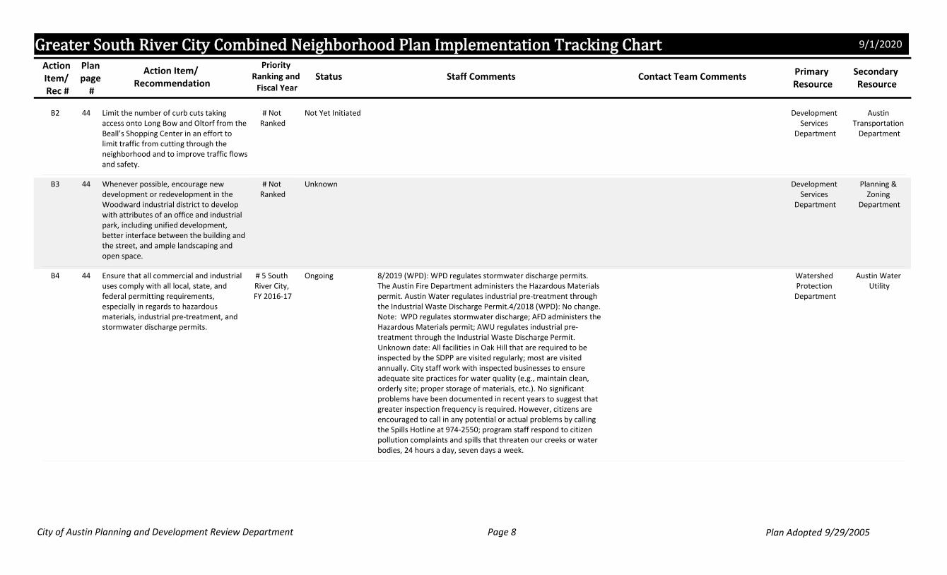
Action Item/ Rec #
Plan page
#
Action Item/ Recommendation
Primary Resource
Secondary Resource
Staff Comments Contact Team CommentsPriority
Ranking and Fiscal Year
Status
Greater South River City Combined Neighborhood Plan Implementation Tracking Chart 9/1/2020
B2 Limit the number of curb cuts taking access onto Long Bow and Oltorf from the Beall’s Shopping Center in an effort to limit traffic from cutting through the neighborhood and to improve traffic flows and safety.
44 Development Services
Department
Austin Transportation
Department
# Not Ranked
Not Yet Initiated
B3 Whenever possible, encourage new development or redevelopment in the Woodward industrial district to develop with attributes of an office and industrial park, including unified development, better interface between the building and the street, and ample landscaping and open space.
44 Development Services
Department
Planning & Zoning
Department
# Not Ranked
Unknown
B4 Ensure that all commercial and industrial uses comply with all local, state, and federal permitting requirements, especially in regards to hazardous materials, industrial pre-treatment, and stormwater discharge permits.
44 Watershed Protection Department
Austin Water Utility
8/2019 (WPD): WPD regulates stormwater discharge permits. The Austin Fire Department administers the Hazardous Materials permit. Austin Water regulates industrial pre-treatment through the Industrial Waste Discharge Permit.4/2018 (WPD): No change. Note: WPD regulates stormwater discharge; AFD administers the Hazardous Materials permit; AWU regulates industrial pre-treatment through the Industrial Waste Discharge Permit. Unknown date: All facilities in Oak Hill that are required to be inspected by the SDPP are visited regularly; most are visited annually. City staff work with inspected businesses to ensure adequate site practices for water quality (e.g., maintain clean, orderly site; proper storage of materials, etc.). No significant problems have been documented in recent years to suggest that greater inspection frequency is required. However, citizens are encouraged to call in any potential or actual problems by calling the Spills Hotline at 974-2550; program staff respond to citizen pollution complaints and spills that threaten our creeks or water bodies, 24 hours a day, seven days a week.
# 5 South River City, FY 2016-17
Ongoing
Plan AdoptedCity of Austin Planning and Development Review Department 9/29/2005Page 8

Action Item/ Rec #
Plan page
#
Action Item/ Recommendation
Primary Resource
Secondary Resource
Staff Comments Contact Team CommentsPriority
Ranking and Fiscal Year
Status
Greater South River City Combined Neighborhood Plan Implementation Tracking Chart 9/1/2020
B5 Develop strategies fostering an eclectic blend of locally owned businesses along South Congress. South Congress should not become a restaurant and bar district similar to downtown’s E. 6th Street. Such strategies may include, but are not limited to: a) Recommend denial of any variance to minimum parking requirements; and b) Hold a forum with residents and business owners from both sides of Congress, economic development specialists, and other experts to conduct a study, make recommendations, and develop an implementation strategy.
45 Contact Team10/2008 (PDR): South River City's #1 priority for FY 2009-10.
# 1 South River City, FY 2016-17
Unknown
B6 Encourage the development of services on S. Congress needed by local residents (grocery store, deli, etc.).
45 Contact Team Planning & Zoning
Department
5/2014 (PDRD): Farm to Market Grocery is located at 1718 S. Congress Ave.
# Not Ranked
Ongoing
B7 Encourage dialogue between the South River City Citizens, Bouldin Neighborhood Association, and the Avenue Merchants Association to find ways to make street festivals such as First Thursdays mutually beneficial to all parties.
45 Contact Team# Not Ranked
Unknown
B8 Collaborate with South Congress business owners and tenants to protect residents in abutting neighborhoods from noise, litter, vandalism, destruction of public property, increased traffic, and parking problems associated with First Thursday.
45 APD# Not Ranked
Unknown
B9 Require events like First Thursday to provide security and additional parking in attempt to minimize these events' impact on the surrounding neighborhoods.
45 Contact Team Public Works2/2010 (ATD): Special events are handled by Right-of-Way Management.
10/2008: St. Edward's #4 priority for FY 2009-10.# 2 South River City &
St. Edward's, FY 2016-17
Unknown
Plan AdoptedCity of Austin Planning and Development Review Department 9/29/2005Page 9

Action Item/ Rec #
Plan page
#
Action Item/ Recommendation
Primary Resource
Secondary Resource
Staff Comments Contact Team CommentsPriority
Ranking and Fiscal Year
Status
Greater South River City Combined Neighborhood Plan Implementation Tracking Chart 9/1/2020
B10 Assign a crew to pick up litter left behind in the neighborhood after First Thursdays.
46 Contact Team Avenue Merchants Association
# Not Ranked
Unknown
B11 Amend the noise and amplified sound ordinance to lower the maximum decibel limit in those areas in proximity to residential uses.
46 APD10/2008: South River City and St. Edward's #2 priority for FY 2009-10.
# 3 South River City, FY 2016-17
Unknown
B12 Explore ways to maximize compliance with the noise and amplified sound ordinance, particularly for those businesses along South Congress.
46 APD# Not Ranked
Unknown
B13 Develop an effective and efficient way for the South River City Citizens Neighborhood Association and property owners to work together to ensure the terms of any development agreements are enforced.
46 Neighborhood Association
Property Owners
10/2008: St. Edward's #3 priority for FY 2009-10.# 1 St. Edward's, FY 2016-17
Unknown
C2 Preserve existing multifamily housing.46 Contact Team Planning & Zoning
Department
10/2008 (NPCT): preserve "low-income multifamily housing." South River City's #9 priority for FY 2009-10.
# Not Ranked
Ongoing
D7b Install signage on Annie St. and Woodland Ave. at Sunset Ln. near the Blunn Creek Greenbelt warning motorists of pedestrian crossings.
51 Austin Transportation
Department
# Not Ranked
Unknown
D18 Clear the storm drains in the area of Annie St. and Eastside Dr. to prevent clogged inlets from flooding and creating a safety hazard.
52 Austin Water Utility
Austin Resource Recovery
# Not Ranked
Unknown
D12 Increase the frequency of route #14.51 Capital Metro9/2014 (PDRD): Route 14 has been eliminated.# Not Ranked
Not Currently Feasible or Recommended
Plan AdoptedCity of Austin Planning and Development Review Department 9/29/2005Page 10

Action Item/ Rec #
Plan page
#
Action Item/ Recommendation
Primary Resource
Secondary Resource
Staff Comments Contact Team CommentsPriority
Ranking and Fiscal Year
Status
Greater South River City Combined Neighborhood Plan Implementation Tracking Chart 9/1/2020
D15 Do not extend Alpine Rd. east to Payload Pass.
51 Austin Transportation
Department
Development Services
Department
2/2010 (ATD): Will be placed in current gap analysis as part of the Austin Strategic Mobility Plan.
10/2008: St. Edward's #8 priority for FY 2009-10.# 4 St. Edward's, FY 2016-17
Unknown
D16 Close the illegal road into St. Edward’s University from St. Edwards Dr.
51 Austin Transportation
Department
# Not Ranked
Unknown
D17 Prohibit access to St. Edward's University from Eastside Dr. in an effort to reduce the amount of cut-through traffic through the Sherwood Oaks subdivision.
52 Austin Transportation
Department
St. Edwards University
# Not Ranked
Not Yet Initiated
D20 Develop ways to mitigate noise emanating from IH-35 from impacting the surrounding neighborhoods.
52 TxDOT Austin Transportation
Department
8/2015 (TXDOT): A noise study is currently underway to determine any impacts the proposed improvements to IH-35 could have. 5/2015 (PZD): Noise mitigation could be considered during the environmental review process for any improvements to South IH-35 that would increase vehicular capacity, such as the Future Transportation Corridor concept proposed as part of the Mobility35 project. Participation of area residents in the related public meetings or surveys is essential.
# Not Ranked
Not Yet Initiated
D22 Keep the neighborhood informed of plans to expand IH-35.
52 TxDOT8/2015 (TXDOT): TxDOT attended the August 3rd SRCC meeting to speak about the project and answer questions from residents. 3/2014 (PDRD): Information is available online at http://www.mobility35.org/.
# Not Ranked
Ongoing
D24 Discourage any variances or waivers for parking reduction on any new or expanding developments and discourage off-site parking, particularly across arterial roadways such as Riverside Dr., S. Congress Ave., IH-35, Ben White Blvd. and Oltorf St.
52 Planning & Zoning
Department
10/2008: South River City's #4 priority for FY 2009-10.
# Not Ranked
Unknown
Plan AdoptedCity of Austin Planning and Development Review Department 9/29/2005Page 11

Action Item/ Rec #
Plan page
#
Action Item/ Recommendation
Primary Resource
Secondary Resource
Staff Comments Contact Team CommentsPriority
Ranking and Fiscal Year
Status
Greater South River City Combined Neighborhood Plan Implementation Tracking Chart 9/1/2020
D26 When properties north of Riverside Dr. near Town Lake redevelop, provide internal streets to improve vehicle circulation and reduce the stress on S. Congress Ave. and Riverside Dr.
52 Development Services
Department
Planning & Zoning
Department
# Not Ranked
Not Yet Initiated
D27 Conduct a comprehensive transportation study of the neighborhood and develop recommendations to promote multi-modal transportation choices.
52 Austin Transportation
Department
# Not Ranked
Unknown
E1 Consistent with the ROMA Town Lake Master Plan, new development along East Bouldin Creek should provide a 80-foot natural buffer from the creek centerline. Variances or waivers to this should only be considered if the proposed development incorporates design and/or environmental features further preserving and enhancing the creek.
53 Planning & Zoning
Department
# Not Ranked
Unknown
E2 Improve the base flows and water quality of Harper’s Branch Creek.
53 Watershed Protection Department
8/2019 (WPD): There is a Grow Zone at the headwaters of Harper's Branch at Heritage Oaks Park. WPD has identified a limited number of potential locations for water quality retrofits, but does not currently have a project planned in the watershed. This is one of the highest-ranking watersheds for water quality in the City, and WPD will continue to actively pursue potential retrofit and partnership opportunities. 4/2018 (WPD) There is a Grow Zone at the headwater of Harper's Branch called Heritage Oaks Park. This areas has potential to improve baseflow quality and quantity overtime. However, Harper's Branch is heavily impacted by the I-35 footprint, and little opportunity for restoration. Contact Program Manager John Clement (512-974-1475) for status and information.
# Not Ranked
Ongoing
Plan AdoptedCity of Austin Planning and Development Review Department 9/29/2005Page 12

Action Item/ Rec #
Plan page
#
Action Item/ Recommendation
Primary Resource
Secondary Resource
Staff Comments Contact Team CommentsPriority
Ranking and Fiscal Year
Status
Greater South River City Combined Neighborhood Plan Implementation Tracking Chart 9/1/2020
E4 Identify, promote, and subsidize detention measures for private lots, including rainwater collection, berm and swale use, soil amendments, etc.
53 Watershed Protection Department
Austin Water Utility
8/2019 (WPD): WPD offers a discount to the monthly drainage charge for homes and businesses that help reducing flooding, erosion, and water quality problems through the voluntary installation of stormwater control measures. In addition, Austin Water offers rebates for Rainscape and Rainwater Harvesting installations. 4/2018 (WPD): Please keep in mind that the City does not have access to private property. WPD provides educational materials for rain gardens, soil amendments, riparian zone restoration, and more. Fliers on these topics are available at libraries and many garden shops, as well as online at http://www.austintexas.gov/department/grow-green-resources. AWU provides subsidies for some water conservation measures; see http://austintexas.gov/department/water-conservation-rebates. Current Code requires capture and water-quality treatment of stormwater for new development over 8,000 sq. ft. IC. (Does not apply to individual, single-family residential building permits.) Flood protection is required for all new development, per the DCM. Hydrology requirements, including flood detention, for new and re-development will be further evaluated as part of CodeNEXT process.
# Not Ranked
Ongoing
E5 Encourage future commercial and multifamily development to incorporate Low Impact Development devices (rain barrels, bioretention ponds, open drainage swales).
53 Development Services
Department
9/2014 (PDRD): The Watershed Protection Department is meeting with stakeholders to develop new regulations for Green Stormwater Infrastructure
# Not Ranked
Underway
Plan AdoptedCity of Austin Planning and Development Review Department 9/29/2005Page 13

Action Item/ Rec #
Plan page
#
Action Item/ Recommendation
Primary Resource
Secondary Resource
Staff Comments Contact Team CommentsPriority
Ranking and Fiscal Year
Status
Greater South River City Combined Neighborhood Plan Implementation Tracking Chart 9/1/2020
E6 Install cedar logs or other measures, including planting native grasses and forbs, along creek banks and in the floodplain to slow the flow of water down banks in an effort to ease problems with erosion.
54 Watershed Protection Department
8/2019 (WPD): Additional ROW vacation and removal of asphalt for the portion of Sunset Lane within Little Stacy Park is planned for later in 2019. This project will also include small conveyance improvements, riparian restoration, and a nature trail 4/2018 (WPD) Little Stacy Roadway vacation project complete in 2018. WPD will remove asphalt roadway, leaving enough for PARD maintenance vehicles. PARD to address Little Stacy site erosion conditions. 5/2015 (PZD): The Little Stacy Park Improvement Project, which will kick-off in Summer 2015, will include measures to correct erosion issues. 5/2014 (PDRD): A City of Austin Urban Forest Grant was awarded in 2008 for education, invasvie species control, and tree planting to restore Blunn Creek. 8/2013 (WPD) Several projects addressing this issue have already been completed, such as the water quality pond in upper Blunn Creek and the rain gardens in Stacy Park. Planned projects include: a rain garden near Woodland to begin construction in Spring 2014, and the Little Stacy Park project.
# Not Ranked
Underway
E7 Work with property owners along Blunn Creek to maintain conservation easements, natural buffers, and pedestrian connections to the greenbelt.
54 PARD Contact Team2/25/10 (PARD): PARD staff is currently working with the neighborhood in accomplishing portions of Blunn Creek to expand the trail.
10/2008: St. Edward's #10 priority for FY 2009-10.# 5 St. Edward's, FY 2016-17
Ongoing
E11 Maintain the vacant AISD property on Alpine Rd. as a water-quality preserve to protect the headwaters of Blunn Creek.
54 AISD Watershed Protection Department
4/2018 (WPD): WPD cannot maintain property that is owned by AISD. If COA acquires the property, which is for sale, then PARD and WPD could coopoeorate on manitenance for recreation and watershed protection. 12/2015 (WPD): This structure in managed by our Field Operations Division. The pond is at the headwaters of the Watershed and is managed for Water Quality purposes. Please contact Program Manager Acayla Haile (512-974-7284) with any vegetation concerns.
# Not Ranked
Ongoing
E12 Include an outdoor educational facility, should a detention and infiltration system be constructed on the AISD tract.
54 AISD# Not Ranked
Unknown
Plan AdoptedCity of Austin Planning and Development Review Department 9/29/2005Page 14

Action Item/ Rec #
Plan page
#
Action Item/ Recommendation
Primary Resource
Secondary Resource
Staff Comments Contact Team CommentsPriority
Ranking and Fiscal Year
Status
Greater South River City Combined Neighborhood Plan Implementation Tracking Chart 9/1/2020
E14 Explore ways to stabilize the trees along Blunn Creek to prevent them from collapsing into the creek until detention ponds or other erosion measures are implemented.
54 Watershed Protection Department
PARD8/2019 (WPD): Additional ROW vacation and removal of asphalt for the portion of Sunset Lane within Little Stacy Park is planned for later in 2019. This project will also include small conveyance improvements, riparian restoration, and a nature trail. 4/2018 (WPD): WPD action is to vacate the ROW along Sunset Lane/Eastside Dr in Little Stacy Park so that it is not a through-street. WPD plans to remove most of the asphalt road and convert to a grow zone, leaving enough pavement for PARD maintenance vehicles. 5/2015 (PZD): The Little Stacy Park Improvement Project, which will kick-off in Summer 2015, will include measures to correct erosion issues. 8/2014 (WPD) This is solved by Action Item E16. The Water Quality pond in upper Blunn Creek is complete. Monroe Bridge Phase 2 is complete. Streambank stabilization for Little Stacy Park is proposed by WPD crews for 2015. Long Bow Storm Drain project (5789.019) is complete. 3/2014 (PDRD): Watershed Protection and Public Works completed a streambank stabilization project along Blunn Creek from Woodland to Live Oak in 2009 that will help prevent further erosion and stabilize trees. 12/2010 (PARD): This is a Watershed recommendation due to the nature of stabilizing creeks.
# Not Ranked
Underway
E19 Notify the neighborhood association prior to conducting dye testing in Blunn Creek to explain the reason for the testing and how to obtain results of the testing upon its conclusion.
55 Watershed Protection Department
Public Information
Office
8/2019 (WPD): It is highly unlikely that a dye trace study would be done in Blunn Creek by Watershed Protection. If conducted, WPD notifies the neighborhood in advance. 4/2018 (WPD) It is highly unlikely that a dye trace study would be done in Blunn Creek by Watershed Protection. We would notify the nieghborhood if done. There may be studies done by other departments/entities (possibly Austin Water or UT Austin).
# Not Ranked
Ongoing
Plan AdoptedCity of Austin Planning and Development Review Department 9/29/2005Page 15

Action Item/ Rec #
Plan page
#
Action Item/ Recommendation
Primary Resource
Secondary Resource
Staff Comments Contact Team CommentsPriority
Ranking and Fiscal Year
Status
Greater South River City Combined Neighborhood Plan Implementation Tracking Chart 9/1/2020
E20 Close Sunset Lane between East Side Dr. and Alameda Ave., remove the pavement and extend Little Stacy Park to mitigate the increasing erosion problem in the area.
55 Austin Transportation
Department
PARD8/2018: Final design inlcudes hill stabilization to address erosion. Design shows two way traffic on Sunset Drive. 12/2015 (WPD): SRCC Neighborhood Association provided letter of support for road closure. WPD is pursuing the ROW vacation process, which will require Council approval. Design and construction to be completed in 2016. 8/2015 (PAZ): The initial public input meeting will be held Sat., August 29, 9-11 AM at Little Stacy Park. 5/2015 (PAZ): The Little Stacy Park Improvement Project, which will kick-off in Summer 2015, may include partial road closure. 4/2015 (WPD): Closure of the road is dependent upon the support of the nieghborhood. 8/2014 (WPD) This is associated with the Little Stacy Streambank Restoration.
# Not Ranked
Not Currently Feasible or Recommended
E21 Work with faculty and students at Travis High School and St. Edward’s University to develop a Blunn Creek research project.
56 Contact Team Watershed Protection Department
1/2017 (WPD) WPD Education has a variety of programs (including Hydrofiles for high school students) Each program has contact information on its website. For a list, please see the Watershed Youth Education website: http://www.austintexas.gov/Watershed/YouthEd. To speak with someone, please contact: Watershed Education Manager – 512-974-2446; Watershed Youth Education – 512-974-6571; Grow Green – 512-974-2581
# Not Ranked
Ongoing
E22 Collect survey information indicating location and size of trees along the Blunn Creek Greenbelt.
57 Contact Team Property Owners
1/2016 (PAZ): A survey of trees near Little Stacy Park will be conducted as part of the park improvement project now underway. A tree preservation plan for the park will be prepared.
# Not Ranked
Underway
E23 Create a volunteer water quality testing program.
57 Contact Team Watershed Protection Department
4/2018 (WPD): WPD staff trains Austin River Watch staff and provides equipment for volunteer training. 8/2014 (WPD) Two monitoring stations, but no volunteer activity. 4/2014 (PDRD): The Watershed Protection Department monitors water quality.
# Not Ranked
Ongoing
E24 Find and index historical photos of Blunn Creek and park to track changes over time.
57 Contact Team Watershed Protection Department
8/2014 (WPD): The Watershed Protection Department has these photos and can provide to citizens as needed. They are not georeferenced.
# Not Ranked
Partially Complete
E26 Monitor for the spread of oak wilt and implement strategies as needed to prevent further contamination.
57 Development Services
Department
PARD5/2014 (PDRD): City of Austin Urban Forest Grants were awarded in 2009 and 2010 for oak wilt suppression on Newning. 12/2010 (PARD): Oak Wilt Program is with the City Arborist. This is a joint effort with PARD and City Arborist.
# Not Ranked
Ongoing
Plan AdoptedCity of Austin Planning and Development Review Department 9/29/2005Page 16

Action Item/ Rec #
Plan page
#
Action Item/ Recommendation
Primary Resource
Secondary Resource
Staff Comments Contact Team CommentsPriority
Ranking and Fiscal Year
Status
Greater South River City Combined Neighborhood Plan Implementation Tracking Chart 9/1/2020
F4 Improve the design and aesthetic of the park tables throughout the Blunn Creek Greenbelt, particularly in the section of the greenbelt on the west side of Blunn Creek across the creek from Travis Heights Elementary
58 PARD# Not Ranked
Unknown
F6 Remove non-native trees and vegetation, such as ligustrum, bamboo, and nandina, along Blunn Creek and replace with native trees and vegetation.
58 Contact Team PARD3/2016 (PAZ): Volunteers removed ligustrum on March 5 for It's My Park Day 2016. 1/2016 (PAZ): Some removal of invasive species and poison ivy is planned in conjunction with the Little Stacy Park Improvement Project. 5/2015 (PZD): Recently, PARD planted 900 seedlings along Blunn Creek. 6/2014 (PDRD): The Blunn Creek Partnership seeks to study, understand, protect and restore the watershed, through work on slowing runoff, removing invasive plants, reintroducing native grasses, sedges, wildflowers, understory and canopy trees. 12/2013 (PDRD): Austin Parks Foundation can help facilitate this kind of project.
10/2008 (NPCT): The neighborhood is active on this item.
# Not Ranked
Ongoing
F8 Improve the design of bridges crossing Blunn Creek to ensure they do not block flow, exacerbating eddying and erosion.
58 PARD Public Works12/2015 (WPD) Check with PARD, this is something that may have been done in the past 5 years.
# Not Ranked
Unknown
F9 Use native materials such as limestone in bridge construction.
58 PARD# Not Ranked
Not Yet Initiated
F14 Address the vandalism and graffiti problems at the Norwood House.
58 APD6/2014 (PDRD): Environmental remediation is currently underway. Construction fencing surrounds the site.
# Not Ranked
Ongoing
F17a Provide bag stations at every park in the neighborhood and along the Blunn Creek Greenbelt to encourage owners to clean up after their dogs -- The Circle ROW Greenbelt.
59 PARD Watershed Protection Department
12/2015(WPD) PARD distributes and maintains these with financial assistance from WPD.
# Not Ranked
Ongoing
F17b Provide bag stations at every park in the neighborhood and along the Blunn Creek Greenbelt to encourage owners to clean up after their dogs -- Blunn Ck. Greenbelt at Rutherford Pl..
59 PARD Watershed Protection Department
8/2019 (WPD): PARD distributes and maintains these with financial assistance from WPD. 12/2015(WPD) PARD distributes and maintains these with financial assistance from WPD.
# Not Ranked
Ongoing
Plan AdoptedCity of Austin Planning and Development Review Department 9/29/2005Page 17

Action Item/ Rec #
Plan page
#
Action Item/ Recommendation
Primary Resource
Secondary Resource
Staff Comments Contact Team CommentsPriority
Ranking and Fiscal Year
Status
Greater South River City Combined Neighborhood Plan Implementation Tracking Chart 9/1/2020
F17c Provide bag stations at every park in the neighborhood and along the Blunn Creek Greenbelt to encourage owners to clean up after their dogs -- Blunn Ck. Pocket Park.
59 PARD Watershed Protection Department
8/2019 (WPD): PARD distributes and maintains these with financial assistance from WPD. 12/2015(WPD) PARD distributes and maintains these with financial assistance from WPD.
# Not Ranked
Ongoing
F17d Provide bag stations at every park in the neighborhood and along the Blunn Creek Greenbelt to encourage owners to clean up after their dogs -- Little Stacy Neighborhood Park.
59 PARD Watershed Protection Department
12/2015 (WPD): PARD distributes and maintains these with financial assistance from WPD.
# Not Ranked
Ongoing
F17e Provide bag stations at every park in the neighborhood and along the Blunn Creek Greenbelt to encourage owners to clean up after their dogs -- Blunn Ck. Greenbelt at Monroe St.
59 PARD Watershed Protection Department
8/2019 (WPD): PARD distributes and maintains these with financial assistance from WPD. 12/2015(WPD) PARD distributes and maintains these with financial assistance from WPD.
# Not Ranked
Ongoing
F17f Provide bag stations at every park in the neighborhood and along the Blunn Creek Greenbelt to encourage owners to clean up after their dogs -- Blunn Ck. Greenbelt at Lockhart Dr..
59 PARD Watershed Protection Department
8/2019 (WPD): PARD distributes and maintains these with financial assistance from WPD. 12/2015(WPD) PARD distributes and maintains these with financial assistance from WPD.
# Not Ranked
Ongoing
F17g Provide bag stations at every park in the neighborhood and along the Blunn Creek Greenbelt to encourage owners to clean up after their dogs -- Blunn Ck. Nature Preserve.
59 PARD Watershed Protection Department
8/2019 (WPD): PARD distributes and maintains these with financial assistance from WPD. 12/2015(WPD) PARD distributes and maintains these with financial assistance from WPD.
# Not Ranked
Ongoing
F21 Collaborate with TxDOT to provide appropriately-scaled lighting along IH-35 near Ben White Blvd.
59 TxDOT Contact Team5/2015 (PZD): Lighting could be considered during the environmental review process for any improvements to South IH-35, such as the Mobility35 project. Participation of area residents in the related public meetings or surveys is essential.
# Not Ranked
Not Yet Initiated
G2 Post speed limit signs on St. Edwards Drive.59 Austin Transportation
Department
10/2014 (PDRD): Signs are in place near the intersections of East Side Drive and St. Edwards Circle with St. Edwards Drive. 2/2010 (ATD): ATD recommends placing stop signs at Carnarvon, St. Edwards Circle, and IH-35 frontage road.
10/2008: St. Edward's #6 priority for FY 2009-10.# 3 St. Edward's, FY 2016-17
Partially Complete
Plan AdoptedCity of Austin Planning and Development Review Department 9/29/2005Page 18

Action Item/ Rec #
Plan page
#
Action Item/ Recommendation
Primary Resource
Secondary Resource
Staff Comments Contact Team CommentsPriority
Ranking and Fiscal Year
Status
Greater South River City Combined Neighborhood Plan Implementation Tracking Chart 9/1/2020
G3 Address problems with automobile break-ins and vandalism in the southern portion of the Travis Heights neighborhood near Oltorf and IH-35.
59 APD10/2008 (PDRD): The NPCT will have to initiate a plan amendment to request to amend this recommendation.
10/2008 (NPCT): Amend the plan to include the entire neighborhood. The problem area has expanded. South River City's #10 priority for FY 2009-10.
# Not Ranked
Unknown
G4 Address the problems with loitering and consumption of alcohol in the "Triangle" Park on South Congress and E. Live Oak.
59 APD# Not Ranked
Unknown
H1 Use planning process to build community, promote youth projects, and avoid typical land use conflicts.
60 Contact Team Planning & Zoning
Department
# Not Ranked
Unknown
COMPLETE
Capital Improvement Project
D1a Construct the following priority sidewalks in the South River City planning area (listed in order of priority): #1. Annie St./Woodland Ave. between S. Congress Ave. and IH-35.
48 Public Works1/2016 (PAZ): The sidewalk is now complete on the north side. 4/2015 (PZD): This sidewalk is scheduled for construction this year, funded by 2012 bonds and fees received from developers in lieu of sidewalk construction. 5/2009 (Public Works): 8,100 linear feet @ $24/SF or $120 lineal foot for the average 5' sidewalk. Sidewalk matrix score: Low/Medium/High.
8/2012: South River City's #1 priority for FY 2013-14. 10/2008: South River City's #6 priority for FY 2009-10.
# Not Ranked
Complete
D1c Construct the following priority sidewalks in the South River City planning area (listed in order of priority) (PW): #3. Travis Heights Blvd. between Riverside Dr. and E. Live Oak St.
48 Public Works10/2016: Sidewalk on west side of street is complete. 1/2016 (PAZ): This sidewalk is under construction. Several ramps have already been installed. 4/2015 (PZD): This sidewalk is scheduled for construction this year, funded by 2012 bonds and fees received from developers in lieu of sidewalk construction. 2/2011 (Public Works): No funding available. 5/2009 (Public Works): Sidewalk matrix score: Low/Medium/High.
8/2012: South River City's #2 priority for FY 2013-14. 10/2008: South River City's #8 priority for FY 2009-10.
# 2 South River City, FY 2016-17
Complete
D3g Construct sidewalks on the following additional streets in the South River City planning area: S. Congress Ave. between Academy Dr. and Elizabeth St.
48 Public Works1/2014 (PDRD): There are sidewalks on both sides of South Congress in this location, as seen in Google Streetview. Sidewalks were installed on the east side south of Gibson Street in 2008-2009.
# Not Ranked
Complete
Plan AdoptedCity of Austin Planning and Development Review Department 9/29/2005Page 19

Action Item/ Rec #
Plan page
#
Action Item/ Recommendation
Primary Resource
Secondary Resource
Staff Comments Contact Team CommentsPriority
Ranking and Fiscal Year
Status
Greater South River City Combined Neighborhood Plan Implementation Tracking Chart 9/1/2020
D6e Construct curb and gutter on the following streets: Payload Pass
51 Austin Transportation
Department
5/2013 (PDRD): A visual confirmation with Google Maps shows that curb and gutter exists entirely along Payload Pass. Improvements were installed in 2005-2007 concurrent with redevelopment.
# Not Ranked
Complete
D8 Amend the Austin Bicycle Plan to designate Live Oak St. from Oltorf St. to S. Congress Ave. and an alternate to Oltorf St.
51 Austin Transportation
Department
2/2015 (PDRD): Bike lanes on East Live Oak Street were improved in October 2014; on-street parking was modified for greater safety and comfort of cyclists. 1/2012 (Public Works): Live Oak is listed on the bicycle map as the east/west bicycle corridor for the area.
# Not Ranked
Complete
D13 Conduct a traffic calming study in the Sherwood Oaks subdivision (within the St. Edward’s Neighborhood Planning Area), particularly on Long Bow Ln. and St. Edwards Dr.
51 Austin Transportation
Department
01/2019 (PAZ): A speed study is complete and ATD is coordinating with PWD and under evaluation. Several speed humps proposed for St. Edwards Dr. from I-35 to Cararvon St. 10/2014 (PDRD): Requests 14A-0018 and 14A-0028 were combined into Request 14A-0040, which is eligible for traffic calming but currently unfunded. 3/2014 (PDRD): Speed mitigation requests 14A-018 and 14A-0028 for St. Edwards Drive from Carnarvon to IH-35 has been accepted into the Local Area Traffic Management Program. A traffic study will be conducted to determine eligibility for traffic calming.
# Not Ranked
Complete
D25 Develop and implement actions to discourage motorists and delivery trucks from cutting through the neighborhood on local streets and speeding through as an alternate route to the arterial roadways between S. Congress Ave. and IH-35.
52 Austin Transportation
Department
3/2014 (PDRD): Speed humps are in place along East Annie Street, East Live Oak Street, East Monroe Street, Kenwood Avenue, Travis Heights Boulevard, East Side Drive, Algarita Avenue, Alta Vista Avenue, Rebel Road, and Newning Avenue.
# Not Ranked
Complete
E10 Explore the possibilities of constructing regional detention and water quality ponds or other measures on privately owned properties, particularly the Austin Independent School District property off Alpine Rd. and the St. Edward’s University property near the Woodward/IH-35 intersection, in order to control downstream flooding and resulting erosion of the stream banks.
54 Watershed Protection Department
5/2015 (WPD): There is no funding programmed in the 5-year plan for creek flood hazard mitigation projects in this area. 5/2014 (WPD): Completed Warehouse Row Regional Ponds in 2011. We have 2 raingardens in Big Stacy Park built in 2008.
# Not Ranked
Complete
Plan AdoptedCity of Austin Planning and Development Review Department 9/29/2005Page 20

Action Item/ Rec #
Plan page
#
Action Item/ Recommendation
Primary Resource
Secondary Resource
Staff Comments Contact Team CommentsPriority
Ranking and Fiscal Year
Status
Greater South River City Combined Neighborhood Plan Implementation Tracking Chart 9/1/2020
E13 Encourage the City to acquire and maintain the property located on Alpine Drive (identified as Tract 120 in the neighborhood plan rezoning ordinance) as a conservation easement.
54 Watershed Protection Department
5/2014 (PDRD): The City acquired this property, located in the 500 block of E. Alpine Road, in 2006. A biofiltration pond was constructed on the property in 2011, and it improves the quality of stormwater runoff from the upstream residential area.
# Not Ranked
Complete
F7 Make repairs as needed to the footbridges crossing Blunn Creek, in particular the bridge near Travis Heights Elementary School and Big Stacy Park.
58 PARD Public Works1/2016 (PAZ): The railing has been repaired and is in good condition.
# Not Ranked
Complete
F12 Extend Town Lake Trail east of the Austin American-Statesman property to IH-35.
58 Public Works PARD6/2014 (PDRD): The boardwalk grand opening will be on June 7, 2014. 1/2014 (PDRD): Construction of the boardwalk trail is 85% complete. The Trail Foundation contributed $3 million to the project, and the remaining costs are funded by 2010 and 2012 bonds. 11/2013 (PDRD): Construction of the boardwalk is 75% complete.
# Not Ranked
Complete
F16 Enhance Norwood Park to include park space and a fenced leash-free area for dogs.
59 PARD10/2008 (M. Laursen, PDR): NPCT will have to initiate a plan amendment to request to remove this recommendation from the neighborhood plan.
10/2008 (NPCT): recommends removing this item from the plan.
# Not Ranked
Complete
F20 Install lower, smaller-scale, dark-sky compatible park lighting, particularly in the area near Little Stacy Park.
59 PARD Austin Energy4/2017: Additional lights installed in the tennis courts at Little Stacy Park. 1/2016 (PAZ): Preparing a lighting plan and selecting fixtures are included in the scope of work for the current park improvement project. 5/2015 (PZD): PARD supports using this type of lighting in parks.
# Not Ranked
Complete
Non-Capital Improvement Project
A2 Design tools should be applied where needed to promote new development that is in character with existing single-family houses.
35 Planning & Zoning
Department
12/2013 (PDR): Impervious cover and parking placement restrictions, garage placement restrictions, front porch placement, and front or side yard parking restrictions were applied at the time of plan adoption.
# Not Ranked
Complete
B1 Add the "Neighborhood Urban Center" special use to the Twin Oaks and Beall’s shopping centers.
44 Planning & Zoning
Department
8/2013 (PDRD): The Neighborhood Urban Center was applied to these sites at the time of plan adoption.
# Not Ranked
Complete
Plan AdoptedCity of Austin Planning and Development Review Department 9/29/2005Page 21

Action Item/ Rec #
Plan page
#
Action Item/ Recommendation
Primary Resource
Secondary Resource
Staff Comments Contact Team CommentsPriority
Ranking and Fiscal Year
Status
Greater South River City Combined Neighborhood Plan Implementation Tracking Chart 9/1/2020
C1 Identify areas where mixed use would enhance the livability of the neighborhoods and rezone accordingly.
46 Contact Team Planning & Zoning
Department
9/2014 (PDRD): Many parcels along South Congress Avenue, South IH-35, and Woodward Street have mixed use zoning.
# Not Ranked
Complete
C3 Allow infill development to occur as indicated in Figure 7.10.
46 Planning & Zoning
Department
Neighborhood Urban Center and Mixed Use Building Infill Tools Applied within Greater South River City Combined Neighborhood Plan Per Implementing Ordinance and Infill Design Tools Booklet. (PDRD, 6/2013)
# Not Ranked
Complete
D7a Install signage on Annie St. and Woodland Ave. at East Side Dr. near the Blunn Creek Greenbelt warning motorists of pedestrian crossings.
51 Austin Transportation
Department
11/2017: Crosswalk and sign at intersetion.# Not Ranked
Complete
D11 Improve the bus stop at Riverside Dr. and Travis Heights Blvd. to include a cover.
51 Capital Metro12/2011 (CapMetro): Complete# Not Ranked
Complete
D19 Prohibit parking on lawns as part of the NPCD ordinance.
52 Code Compliance Department
Per ORDINANCE NO. 20050929-Z002; Front or side yard parking restrictions apply as set forth in Section 25-2-1406 and Section 12-5-29 of the Code. (PDRD, 5/13)
# Not Ranked
Complete
D23 Identify parking spillover problems into neighborhoods from commercial and multifamily developments and support petitions for residential-parking-only designation on these streets.
52 Contact Team1/2016 (PAZ): The residential parking permit program has been deployed on several streets in the Travis Heights neighborhood, such as Gibson Street, Elizabeth Street, Monroe Street, Academy Drive, The Circle, Milton Street, and Park Lane.
10/2008: South River City's #3 priority for FY 2009-10.
# 4 South River City, FY 2016-17
Complete
Plan AdoptedCity of Austin Planning and Development Review Department 9/29/2005Page 22

Action Item/ Rec #
Plan page
#
Action Item/ Recommendation
Primary Resource
Secondary Resource
Staff Comments Contact Team CommentsPriority
Ranking and Fiscal Year
Status
Greater South River City Combined Neighborhood Plan Implementation Tracking Chart 9/1/2020
E3 Encourage the City to adopt greater water quality protections for urban watersheds consistent with the proposed Headwaters Protection Ordinance developed by Watershed Protection and Development Review staff.
53 Watershed Protection Department
Contact Team12/2013 (WPD): The Watershed Protection Ordinance, passed 10/17/2013, provides headwater protection for all creeks beginning at 64 acres of drainage; increases development setbacks for creeks in previously unprotected or less-protected eastern (Suburban) watersheds; provides additional protection for critical environmental features; and requires development to be outside of an erosion hazard zone to keep buildings, roadways and utilities from being constructed in harms way. 2/2010 (WPD): With few remaining undeveloped tracts within the planning area, regulatory changes will not provide a measurable level of protection. Other strategies, such as monitoring of "hot spot" businesses that can disproportionately pollute, retrofitting of structural controls, and many other strategies are therefore more advisable to this and other urbanized areas.
10/2008: South River City's #5 priority for FY 2009-10.
# Not Ranked
Complete
E15 Explore and implement methods to capture and release the run-off from the Travis Heights Elementary School site in a more effective manner.
54 Watershed Protection Department
8/2013 (WPD) Several projects addressing this issue have already been completed.
# Not Ranked
Complete
E18 Compile and make available to the public the results of previous studies and inventories measuring the base flows and water quality of Blunn Creek.
55 Watershed Protection Department
Public Information
Office
12/2015 (WPD): The Environmental Integrity Index program continuously monitors and assess the chemical, biological, and physical integrity of Austin’s creeks and streams. Environmental Integrity Index reports are available (https://austintexas.gov/department/environmental-integrity-index), and all data may be accessed (https://data.austintexas.gov/Environmental/Water-Quality-Sampling-Data/5tye-7ray).
# Not Ranked
Complete
E25 Resolve the localized flooding problems on St. Edwards Drive between Sherwood Lane and Friar Tuck Lane.
57 Watershed Protection Department
5/1/2015 (WPD) Long Bow SDI (5789.019) Improved flooding solution.
# Not Ranked
Complete
F11 Create a Citywide bird watching location list, including recognition and protection of Blunn Creek as prime site.
58 Contact Team5/2014 (PDRD): Texas Parks and Wildlife offers such a guide online. Blunn Creek Preserve is featured on the following webpage: http://www.tpwd.state.tx.us/publications/pwdpubs/pwd_br_w7000_0328/south/
# Not Ranked
Complete
Plan AdoptedCity of Austin Planning and Development Review Department 9/29/2005Page 23

Action Item/ Rec #
Plan page
#
Action Item/ Recommendation
Primary Resource
Secondary Resource
Staff Comments Contact Team CommentsPriority
Ranking and Fiscal Year
Status
Greater South River City Combined Neighborhood Plan Implementation Tracking Chart 9/1/2020
F13 Work with neighborhood stakeholders to find a viable use for the Norwood House.
58 PARD6/2014 (PDRD): The City and non-profit Norwood Park Foundation entered into a Parkland Improvement, Management and Operations Agreement in 2013 that allows for the rehabilitation of the Norwood House and grounds and management and operations of the completed facility by Norwood Park Foundation as a community meeting space and revenue- generating event facility. Environmental remediation is currently underway.
# Not Ranked
Complete
F19 Maintain "Ravine Park" as permanent open space.
59 PARD4/2014 (PDRD): This property, located at 1300 The Circle, is a city-owned greenbelt.
# Not Ranked
Complete
Plan AdoptedCity of Austin Planning and Development Review Department 9/29/2005Page 24